Chapter 13 - Land Identification and Real Property Descriptions
Introduction
All land is subject to ownership, whether by governmental or private entities. In order to physically and legally establish this ownership, a need to describe the boundaries of the land was created. The resulting method of land description, called a legal description, identifies a parcel of real property in such terms that it cannot be confused with any other parcel.
The purpose of this section will be to explain the various land description methods and how to rewrite legal descriptions to a condensed form.
Land Description Methods
There are four primary methods of land legal descriptions used in identifying land in Colorado. The methods are:
- United States Governmental Survey System, often referred to as the "rectangular survey system"
- Metes and bounds
- Lot and block system, sometimes called the "recorded plat system"
- Colorado Coordinate System
In addition, some land descriptions in several southern Colorado counties refer to the original land grant. Although these land grants are still referenced, all parcels within the original grants have alternative metes and bounds descriptions.
United States Governmental Survey System
Background
After the Revolutionary War, new areas of the United States public domain were added through discovery, treaties, and purchases. It became apparent to our government leaders that a plan must be worked out for selling and locating lands in this added territory.
In 1784, a committee headed by Thomas Jefferson authored the original rectangular survey plan, which was adopted by the Continental Congress. From 1785 to 1832, this plan underwent modification until the smallest statutory unit of subdivision was the quarter-quarter section (40 acres). This system became the principal land survey system for several states east of the Mississippi River and for most lands west of the Mississippi River. Any land settled prior to the act was not included and is still described by a metes and bounds description.
Base Lines and Principal Meridians
The purpose of the United States Government Survey System was to create a checkerboard of identical squares covering a given area of land. The first step in using this system was to establish an imaginary line running east and west, called a base line, and another imaginary line running north and south, called a principal meridian. These lines were tied, by celestial observations, to the worldwide system of latitude (east and west), and longitude (north and south) measures.
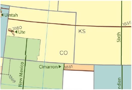
In Colorado, the three principal meridians and base lines in use are:
- The Sixth (6th) Principal Meridian and the Forty Degrees North Latitude Base Line
- The New Mexico Principal Meridian and the New Mexico Base Line
- The Ute Principal Meridian and the Ute Base Line
For an illustration of the principal meridians and base lines governing Colorado, please refer to Addendum 13-A, Public Land Survey System in Colorado, found at the end of this section.
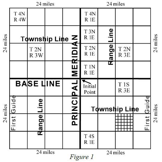
After establishing the base line and principal meridian, the second step was dividing the land into six-mile square areas. This established parallel lines six miles apart both east and west of the principal meridian and parallel lines six miles apart both north and south of the base line. The lines running parallel to the base line are called township lines. The lines running parallel to the principal meridian are called range lines.
Typically, the range line that lies every 24 miles east and west of the principal meridian is also called a guide meridian. Each guide meridian ends where the line intersects a standard parallel. The purpose of this line is to act as a correction line to adjust the rectangular townships to the curvature of the earth.
Standard parallels, often called correction lines, serve the same purpose as guide meridians. Typically, standard parallel lines are the township lines located every 24 miles north and south of the base line.
In Colorado, the original surveys done in the 1800s created guide meridians and standard parallels at different intervals other than the 24-mile interval currently used. Meridians and parallels created pursuant to these old surveys are still valid. In addition, auxiliary guide meridians and standard parallel lines were established when additional governing lines were needed. Auxiliary meridians and parallel lines are similar to regular meridians and parallels. Refer to Figure 1 for an illustration of meridians, baselines, townships, and ranges.
Townships and Sections
When township lines and range lines intersect, they create rectangles called townships. A standard township is six miles square and contains 36 square miles. Because of the earth’s convergence of longitude lines, townships are about 3 rods or 49.5 feet narrower at the top (north) than at the bottom (south).
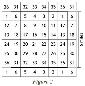
Each township is further divided into 36 one-mile square tracts called sections. Refer to Figure 2 for an illustration. A standard section contains 640 acres. Sections within a township are numbered consecutively from the northeast corner, following a back and forth course, until the last section in the southeast corner is numbered. At each of the four section corners, government surveyors placed a marker known as a “survey monument.” The composition of a survey monument depends on what materials were available in the locale under survey.
In most of Colorado, rocks were piled with one prominent stone selected as the marker. “Hash marks” or lines in the rock were chiseled indicating the location of the section within the township. In areas with few rocks, wooden posts or even growing trees were used.
Understanding the Rectangular Survey System
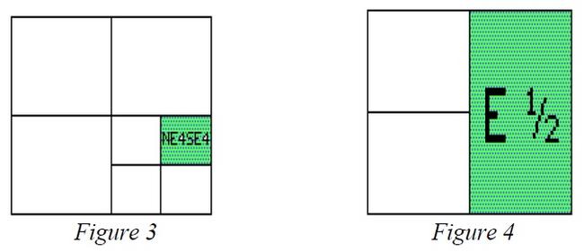
The proper understanding and writing of a legal description requires the reader to go from the specific to the general. The cardinal compass directions (north, south, east, and west) are used to locate tracts within each section. For purposes of land description, sections are commonly divided into half sections containing 320 acres, quarter sections containing 160 acres, and so forth. A legal description is written by describing the exact tract within the section and ends with the name of the principal meridian. An example legal description of a 40-acre parcel of land is:
NE¼SE¼, section 6, township 3 north, range 6 west, 6th Principal Meridian.
It is very important that the proper punctuation be used in separating the initial components of the description. The above description showing NE¼SE¼ without a comma between the two quarters is the NE¼ of the SE¼, a 40-acre tract.
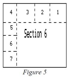
By placing a comma between the quarters for example, NE¼, SE¼, a 320-acre tract more commonly known as the E½ of the section is described. Commas should also separate the section, township, and range so that the intent of the description is clear. Refer to Figure 3 and Figure 4 for illustrations of both tracts mentioned.
Government Lots
Government lots are tracts of land which usually exist adjacent to the northern and western borders of each township. Because of the curvature of the earth, the convergence of the longitude lines or meridians, and human errors, the subdivision of townships into sections could not be surveyed as accurately as it could be drawn on paper. To take care of these discrepancies and still have as many uniform sections of 640 acres in each township as possible, corrections to the sections were made on the north and west sides of each township. Consequently, sections 1 through 6 on the northern township border and sections 6, 7, 18, 19, 30, and 31 on the western township border may contain either more or less than 640 acres. Corrections within these specific numbered sections were made in that fraction of the section lying closest to the north and west lines of the township. These odd-sized subdivisions of a section were referred to as “government lots.” Government lots are given individual lot numbers rather than being described by compass directions, because they contain more or less than 40 acres of land. In the example shown in Figure 5, a tract of land, known as the NE¼NE¼ of Section 6, is assigned government lot number 1.
The use of lot numbers in legal descriptions is the proper way to describe these tracts. However, a cross reference can be made to show the location of the lot involved. For example, this description is proper:
Lot 1 (NE¼NE¼) of section 6, township 4 south, range 64 west, 6th Principal Meridian
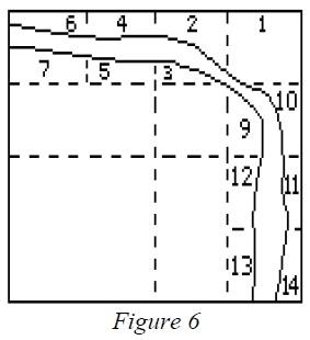
Government lot numbers were also used when physical barriers prevented the establishment of complete 40-acre tracts. Lots were established where rivers, lake, and cliffs were located on the land under survey, as shown in Figure 6. Governmental lots established because of physical limitations can occur in any section of a township.
Obtaining Information on U.S. Government Surveys
When an original government survey was completed, a copy of the surveyor’s field notes was filed in the office of the county clerk and recorder, with the county engineer, or both. However, these field notes may require an engineer or surveyor to translate them. The best source of information for data pertaining to the original survey or resurveys is the Bureau of Land Management (BLM). Data available from this agency includes, but is not limited to:
- Initial survey and resurvey plats, (if any)
- Surveyor’s field notes
- Mineral survey plats and field notes
- Lot numbers, acreage, and acreage re-surveys
- Original patents
- Unpatented claims
For additional information and copies of maps of the above information, contact the BLM at:
United States Department of Interior
Bureau of Land Management - Colorado State Office
2850 Youngfield Street
Lakewood, CO 80215
Bureau of Land Management Website
Phone: 303-239-3600
Metes and Bounds Descriptions
In Colorado, the predominant method of land description is the government rectangular survey system. However, in areas not covered by the rectangular survey system or when it is necessary or desirable to describe an irregular tract, the land is described by metes and bounds.
Metes and bounds descriptions come from a system that measures and identifies land by describing the land’s boundaries, based on the land’s relation to its natural and cultural features. These features are called monuments. This method starts with a well-marked point of beginning and follows the boundaries of the parcel until it returns to the point of beginning.
Metes and bounds descriptions are expressed in bearings and distances. The direction of a line (its bearing) is stated in terms of the angle it makes with a true north-south line through the point of beginning. A bearing is described in degrees and fractions of a degree (minutes and seconds) from the cardinal directions of north or south, such as N 87º 29' 45" E 482 feet. A distance is the length of a line. It is generally stated in feet, but may also be stated in chains, rods, or other lineal measurements. A conversion chart is provided in Addendum 13-B, Typical Measurement Units and Conversions.
Every modern bearing has degrees and minutes of angulation, and sometimes, even seconds. There are 360 degrees (360º) in a complete circle with 180º between north and south or between east and west. Between north and east, north and west, south and east, and south and west there are 90o. If you were to measure N. 90º E., you would be measuring due east. In each degree (º), there are 60 minutes (60'); 30' is 1/2 a degree; 15' is found halfway between the degree and the half-degree marks. In each minute (') there are 60 seconds (60").
Example - Metes and bounds description
A tract of land in the northwest one-quarter of the northwest one-quarter (NW¼NW¼) of section 30, township 1 south, range 60 west of the 6th P.M., more particularly described as follows: Commencing from the northwest corner of said section 30; thence south 20º30' east 140.60 feet to the point of beginning; thence north 88º55' east 200 feet; thence south 125 feet; thence south 88º55' west 200 feet; thence north 125 feet to the point of beginning, County of Adams, State of Colorado.
Metes and bounds descriptions used in Colorado always tie to some established corner or line of an existing public lands survey or to recognized corners or lines of a recorded plat. Metes and bounds should be established by a registered land surveyor. Surveys cannot be used as official description reference unless made by a registered surveyor.
NOTE: Documents executed and recorded after July 1, 1992, which contain a newly created legal description must include the name and address of the person who created the legal description, § 38-35-106.5, C.R.S.
In several Colorado counties, large tracts of land known as land grants exist and are referenced in legal descriptions. Under a land grant, large tracts of unsurveyed and generally uninhabited land were conveyed to individuals and/or companies. The tracts were later divided into large agricultural tracts and/or smaller lot and block town sites.
Nearly all the land grants in Colorado are called Spanish land grants. These land grants were given by the king of Spain to favored individuals for services rendered to the Crown. Today, the boundaries of these grants have been established by metes and bounds descriptions and are subdivided into parcels described by metes and bounds and/or the rectangular survey systems.
Lot and Block Descriptions
The lot and block method is one of the earliest land description methods. Lots and blocks were used in Colonial America before the rectangular survey system was instituted.
In Colorado, the lot and block method began when land developers subdivided land described by the rectangular survey system and needed more detail to identify the individual sites they were creating. Each block and lot can be identified and located in relation to the monumented corners established as part of the subdivision boundary metes and bounds description. The subdivision boundary is then “tied” to government survey points of the original rectangular survey.
A tract of land may be subdivided into blocks and lots, with proposed streets, alleys, public utility easements and such other information that the owner desires to include as part of the plan for the tract. A map, called a plat, is created which identifies all blocks and lots by number and shows boundaries and measurements of the lots, blocks, and complete land tract. The plat is then submitted to the local planning commission and/or county commissioners for approval.
After the required local governmental approval, the plat is recorded in the office of the county clerk and recorder for permanent reference. Any lot of a recorded plat can thereafter be legally described and conveyed by simple reference to the lot and/or block numbers as shown on the plat. Each platted area is given a name, such as “Pine Meadows Subdivision” or “Riverside Addition” to distinguish it from other subdivided areas.
Example - Lot and block description from a recorded plat
“Lots 4 and 5, Block 26, Riverside Addition to the City of Fort Morgan, Colorado”
Colorado Coordinate System
The Colorado coordinate system is part of the state plane coordinate system established in 1933 by the United States Coast and Geodetic Survey agency, which later became the United States Geodetic Survey. This state plane coordinate system locates the boundary points of land parcels on a state coordinate grid in the same manner as graph paper is used to locate the points of a line graph. The state coordinate system is comprised of rectangular grids designed to fit the curved shape of the earth to a plane (flat) surface with as little distortion as possible.
A coordinate system establishes a set of two or more numerical values used to determine the position of a point, line, curve, or plane. For example, the intersection of latitude and longitude lines are coordinates for a point on the earth’s surface. For many years, professional land surveyors and engineers have used various types of coordinate systems.
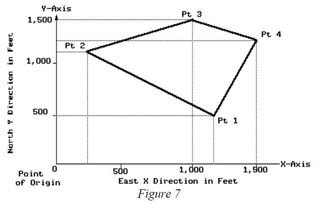
In using the system, a point on the boundary of a tract is expressed in two distances in feet and decimals of a foot. An east-west direction is known as the "X-coordinate" and the north-south direction is known as the "Y-coordinate." The precise coordinates for the points of origin have been determined by the National Geodetic Survey. A sample is provided in Figure 7.
The United States is covered by a network of triangulation and traverse stations which determine the latitudes and longitudes of thousands of benchmark points. For each state, the U.S. National Geodetic Survey has devised a system of plane-rectangular coordinates for the purpose of stating the locations of established monuments and other points with reference to a point of origin.
Because Colorado is a large state, the state coordinate system is divided into three zones, each of which has its own plane-rectangular map projection. The appropriate zone must be stated in the legal description. When any tract of land to be defined by a single description extends from one zone into another, the positions of all points on its boundaries may be described according to either of the two zones. The zone used must be specifically named in the description.
Whenever the Colorado Coordinate System and the rectangular survey system are used to describe a tract of land in the same document, the description by rectangular survey shall control. In the event of a conflict of the two descriptions, the rectangular survey description shall prevail unless the coordinate description is upheld by adjudication.
Example – Metes and bounds description using state plane coordinates as supplemental information
Commencing at the corner of section 20, 21, 28, and 29, township 4 south, range 75 west, 6th P.M. and bearing north 20º15' west 202.50 feet to the point of beginning which is marked by a 5/8" diameter iron rod set in concrete; then bearing north 79º45' West 155 feet to a brass marker set in a granite ledge and stamped “2928,” said brass marker having grid coordinates X=1,916,572.14, and Y=624,697.82, on the Colorado Coordinate System, Central Zone; then south 22º45' west 106.50 feet; then south 70º15' east 145 feet; then north 25º30' east 133.50 feet to the point of beginning.
In Colorado, as in most states, the plane coordinate system developed by the National Geodetic survey has been approved by an act of the general assembly. The Colorado Coordinate System became effective July 1, 1967 and sections 38-52-101 through 107, C.R.S., pertain to its establishment and use. Its use is not mandatory at this time, but the system may become commonplace in the future.
For further information on this method of land description, refer to the Colorado Coordinate System statutes or contact a registered land surveyor.
Condensing Legal Descriptions
Many assessment roll legal descriptions in Colorado can be condensed by 25 to 50 percent. To create a condensed legal description:
- Rewrite descriptions in a shorter format;
- Use accepted abbreviations; and
- Eliminate unnecessary words and phrases.
Legal descriptions should not be condensed in any other manner.
Rewriting Legal Descriptions
Colorado statute allows for legal descriptions to be rewritten by the assessor.
Property described.
In listing tracts or parcels of real property, the assessor shall identify the same by section, or part of a section, township, and range, and if such part of a section is not a legal subdivision, then by some other description sufficient to identify the same. In listing town or city lots, he shall describe the same by number of lot and block, or otherwise, in accordance with the system of numbering or describing used by the town or city in which said lots are located.
§ 39-5-103, C.R.S.
An assessor has the authority to rewrite any description. The description is considered valid if it correctly and effectively describes the parcel so the parcel cannot be confused with any other parcel.
Descriptions should be rewritten only after parcels have been plotted on assessment maps. Information pertinent to each parcel, such as bearings or angles, distances, and acreage should be entered on the assessment maps. Condensed descriptions are written from information on the deed and assessment map and old descriptions from the assessor’s records. The condensed descriptions should be rechecked later for errors.
In understanding legal descriptions, you may encounter unfamiliar measurement terminology. Refer to Addendum 13-B, Typical Measurement Units and Conversions, for measurement terms.
Using Accepted Abbreviations
Abbreviations may be used for purposes of property taxation and collection.
Abbreviations, letters, and figures may be used.
In all advertisements for the sale of real property for taxes and in entries required to be made by the assessor, county clerk and recorder, treasurer, or other officers in lists, books, rolls, certificates, receipts, deeds, or notices, letters, figures, and abbreviations may be used to denote townships, ranges, sections, parts of sections, lots, blocks, dates and amounts of taxes, penalty interest, and costs.
§ 39-11-113, C.R.S.
Refer to Addendum 13-C, List of Abbreviations, listing of suggested abbreviations.
Eliminating Excess Words and Phrases
All words that are unnecessary to correctly and effectively describe or plat a parcel may be eliminated. When the bearing and distance is given for a course or meander, everything except the bearing and distance is unnecessary. In the following description, the most common forms of excess wordage found in deed descriptions are illustrated. The parts not underlined could be eliminated.
That part of the S½ of the NE¼ of the NE¼ of Sec 12, T 10 N, R 57 W commencing at the NE corner of said NE¼ of the NE¼ Sec 12, T 10 N, R 57 W, thence W 66 feet to W boundary of Highway Colo. 52, thence south along said right-of-way a distance of 660 feet for a point of beginning; thence west a distance of 594 feet to the SW corner of the NE¼ of the NE¼ of the NE¼; thence south a distance of 660 feet from said SW corner of the NE¼ of the NE¼ of the NE¼ to an iron stake two inches in diameter on the S line of the NE¼ of the NE¼, section 12, T 10 N, R 57 W; thence east a distance of 594 feet along said South line of said NE¼ of the NE¼ to a point on the west boundary of the right-of-way of highway Colo. 52; thence north a distance of 660 feet along west boundary of said right-of-way to the point of beginning, containing 9 acres.
By eliminating the words that are not underlined and using standard abbreviations, the description can be written in brief form as follows:
Com. at NE cor. Sec. 12, T 10 N., R 57 W; th. W. 66 ft.; th. S. 660 ft. to P.O.B.; th. W. 594 ft.; th. S 660 ft. th. E. 594 ft; th, N 660 ft. to P.O.B.; 9 A.
Some phrases cannot be eliminated when rewriting descriptions. Two phrases often eliminated, but which are usually necessary to plot descriptions, are, “parallel” and “at right angle to.” Examples are “thence northerly parallel to East line 100 feet” or “thence northerly at a right angle to the last mentioned line a distance of 100 feet.”
However, if the bearing of the east line is previously given in the description, this bearing may be used instead of the phrase. Also, if the bearing of the last mentioned line is given, the right angle of the northerly bearing may be computed and used instead of the phrase.
The inclusion of the following items will ensure clear legal land descriptions:
- Principal meridian (if you have more than one in your county)
- Township and range
- Section number
- Quarter section, quarter-quarter section, etc.
- Acreage
- Reception number and deed date, or book and page
Summary
The need for land description was created when land became subject to ownership. For physical and legal reasons, land description methods were developed to identify land in specific terms such that one parcel cannot be confused with any other parcel.
In Colorado, there are four primary land description methods:
- United States Governmental Survey System
- Metes and bounds
- Lots and blocks
- Colorado Coordinate System
The purpose of any land description method is to generate a legal description for every parcel.
Legal descriptions can be condensed by the assessor as a method of saving space in office files. Excess words and phrases can be eliminated and abbreviations used as long as the description is still understandable.
Addendum 13-A, Public Land Survey System in Colorado
Baselines and Prime Meridians for Colorado
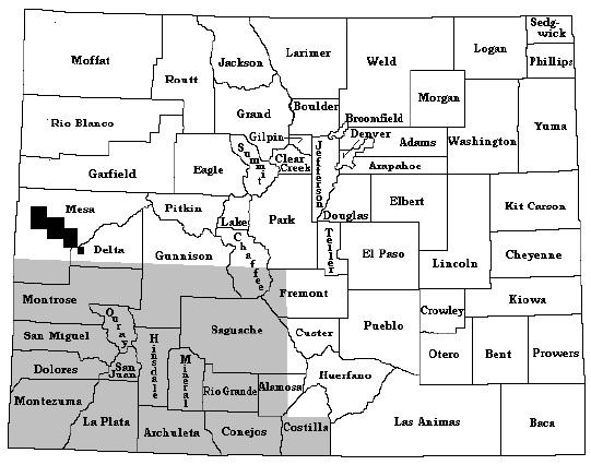
County Boundaries and Survey Areas
Addendum 13-B, Typical Measurement Units and Conversions
Below is a listing of commonly used measurement units and their conversions that can be found in Colorado legal descriptions.
Measurements of Length
1 foot = 12 inches
3 feet = 1 yard
1,760 yards = 1 mile
5,280 feet = 1 mile
2.54 centimeters = 1 inch
39.37 inches = 1 meter
3.281 feet = 1 meter
1,000 meters = 1 kilometer
Public Land Survey System Measurements
7.92 inches = 1 link
25 links = 1 rod
16.5 feet = 1 rod
100 links = 1 chain
4 rods = 1 chain
80 chains = 1 mile
320 rods = 1 mile
Measurements of Area
144 square (sq.) inches = 1 sq. foot
43,560 sq. ft. = 1 acre
160 sq. rods = 1 acre
16 sq. rods = 1 sq. chain
10 sq. chains = 1 acre
640 acres = 1 sq. mile
36 sq. miles = 1 township
1 sq. mile = 2.59 sq. kilometers
Measurements of Angles
60 seconds (") = 1 minute (')
60 minutes = 1 degree (o)
360 degrees = 1 circle
Addendum 13-C, List of Abbreviations
Below is a listing of abbreviations that are recommended in rewriting legal descriptions. All abbreviations will be given capital or lower-case letters the same as would be proper if the spelling were to be completed.
| Term | Abbreviation |
|---|---|
| Abstract | Abstr. |
| Acre | A.; Ac. |
| Addition | Addn.; Add. |
| Adjoining, Adjacent | Adj. |
| Also known as | A.K.A. |
| Amended | Am. |
| And Others | Et.Al.; et.al. |
| And Spouse | Et.Ux. |
| Angle | Ang.; < |
| Assessor(s) | Ass'r(s). |
| Avenue | Ave. |
| Beginning | Beg. |
| Between | Bet. |
| Block | Blk. |
| Book | Bk. |
| Bound, Bounded | Bd. |
| Boundary | Bdy.; Bdrs. |
| Building | Bldg. |
| Center | Ctr.; C. |
| Center Line | C.L.; C/L |
| Central Angle | C/A |
| Chain | Ch. |
| Commence, Commencing | Com. |
| Containing | Contg. |
| Continue | Cont. |
| Continuing | Contn. |
| Continued | Contd. |
| Corner(s) | Cor(s). |
| Correction | Corr. |
| Curve | Cv. |
| Dedication | Ded. |
| Degree | o or Deg. |
| Description, Described | Desc. |
| Diagonal | Diag. |
| Diameter | Diam. |
| Distance, District | Dist. |
| Easement | Esmt. |
| East | E. |
| Easterly | Ely. |
| Established, Estimated | Est. |
| Except | Ex.; Exc. |
| Filing | Flg. |
| Following | Fol. |
| Foot, Feet | Ft. |
| Fraction(al) | Fr(l). |
| From | Fr. |
| General Land Office Survey | G.L.O. |
| Government Lot | Gov't Lt. |
| Highway | Hwy. |
| Horizontal | Hor. |
| Inch(es) | In(s). |
| Including, Inclusive | Incl. |
| Incorporated | Inc. |
| Interest | Int. |
| Intersection | Inters. |
| Irregular | Irreg. |
| Left | Lt. |
| Line | Ln. |
| Link(s) | Lk(s). |
| Located, Location | Loc. |
| Lot | Lt. |
| Lying | Lyg. |
| Meridian | M.;Mer. |
| Mile | Mi. |
| Minutes | ' or M. |
| Miscellaneous | Misc. |
| More or Less | M/L |
| North | N. |
| Northeast | NE. |
| Northeasterly | Nely. |
| Northerly | Nly. |
| Northwest | NW. |
| Northwesterly | Nwly. |
| Number | No. |
| One half | 1/2 |
| One fourth | 1/4 |
| Original | Orig. |
| Page(s) | P.(PP) |
| Parallel | //; Par. |
| Place | Pl. |
| Point or Part | Pt. |
| Point of Beginning | P.O.B. |
| Point of Curvature | P.C. |
| Point of Ending | P.O.E. |
| Point of Tangency | P.T. |
| Portion | Ptn. |
| Principal | Prin.; P. |
| Private Claim | P.C. |
| Quarter | Qtr.; 1/4 |
| Radius | Rad. |
| Railroad | R.R. |
| Railway | Rwy. |
| Range(s) | R(s). |
| Reserve | Res. |
| Resubdivision | Resub. |
| Right | Rt. |
| Right of way | R/W; ROW. |
| Rods | Rds. |
| Running | Rng. |
| Said | Sd. |
| Seconds | " ; S. |
| Section(s) | Sec(s). |
| South | S. |
| Southeast | SE. |
| Southeasterly | SEly. |
| Southerly | Sly. |
| Southwest | SW. |
| Southwesterly | SWly. |
| Square | Sq. |
| Street(s) | St(s). |
| Strip | Stp. |
| Subdivision | Sub. |
| Thence, Then | Th. |
| Town | T. |
| Township(s) | Tp(s). |
| Tract | Tr. |
| Undivided | Und. |
| Unincorporated | Uninc. |
| Variation | Var. |
| Village | Vill. |
| West | W. |
| Westerly | Wly. |
| Whence | Wh. |