The Importance of Correct Land Valuation
Under all is the Land!
This statement is a time-honored maxim in the understanding of the concept of real property. Because all people use land, whether as a source for food or as a foundation for shelter, land use serves as the cornerstone for establishing the desirability and ultimate worth of real property.
Land valuation is an essential part of a good appraisal program. A correct appraisal is absolutely dependent on a correct land value. Consider how having an accurate land value relates to the cost approach. The formula is as follows:
Land Value + ((Improvement) Replacement Cost New - Depreciation) = Estimate of Value
If the land value is incorrect, the estimate of value for the total property will also be incorrect.
Like most states, Colorado statutes require the assessor to value land separately from improvements, § 39-5-105(1), C.R.S. There are practical reasons for separation of land and improvements:
- Trends and factors affecting land and improvements can be studied separately.
- In land use analysis, it is necessary to determine the current use of the land.
- It is mandatory in the valuation of real property by the cost approach.
- It is necessary for the calculation of improvement depreciation tables.
Accurate land values also play an important part in the valuation of the improvements. A confirmed sales price includes both land and improvement value components. The depreciated value of the improvements is determined by subtracting the land value from the sales price. When this depreciated improvement value is compared to the replacement cost new, the result is market derived depreciation. The amount of market derived depreciation can be calculated on an annual basis and placed in a depreciation table. The depreciation table can be used in setting improvement values for ad valorem purposes.
Statutory and Case Law References
Colorado statutes define land as a part of real property. This definition is as follows.
Definitions.
(14) “Real property” means:
(a) All lands or interests in lands to which title or the right of title has been acquired from the government of the United States or from sovereign authority ratified by treaties entered into by the United States, or from the state;
(b) All mines, quarries, and minerals in and under the land, and all rights and privileges thereunto appertaining; and
(c) Improvements.
§ 39-1-102, C.R.S.
Colorado statutes further define vacant land and require specific procedures when using the market approach to value such land.
Actual value determined - when.
(14)(b) The assessing officers shall give appropriate consideration to the cost approach, market approach, and income approach to appraisal as required by the provisions of section 3 of article X of the state constitution in determining the actual value of vacant land. When using the market approach to appraisal in determining the actual value of vacant land as of the assessment date, assessing officers shall take into account, but need not limit their consideration to, the following factors: The anticipated market absorption rate, the size and location of such land, the direct costs of development, any amenities, any site improvements, access, and use. When using anticipated market absorption rates, the assessing officers shall use appropriate discount factors in determining the present worth of vacant land until eighty percent of the lots within an approved plat have been sold and shall include all vacant land in the approved plat. For purposes of such discounting, direct costs of development shall be taken into account. The use of present worth shall reflect the anticipated market absorption rate for the lots within such plat, but such time period shall not generally exceed thirty years. For purposes of this paragraph (b), no indirect costs of development, including, but not limited to, costs relating to marketing, overhead, or profit, shall be considered or taken into account.
(c)(I) For purposes of this subsection (14), "vacant land" means any lot, parcel, site, or tract of land upon which no buildings or fixtures, other than minor structures, are located. "Vacant land" may include land with site improvements. "Vacant land" includes land that is part of a development tract or subdivision when using present worth discounting in the market approach to appraisal; however, "vacant land" shall not include any lots within such subdivision or any portion of such development tract that improvements, other than site improvements or minor structures, have been erected upon or affixed thereto. "Vacant land" does not include agricultural land, producing oil and gas properties, severed mineral interests, and all mines, whether producing or nonproducing.
(II) For purposes of this subsection (14):
(A) "Minor structures" means improvements that do not add value to the land on which they are located and that are not suitable to be used for and are not actually used for any commercial, residential, or agricultural purpose.
(B) "Site improvements" means streets with curbs and gutters, culverts and other sewage and drainage facilities, and utility easements and hookups for individual lots or parcels.§ 39-1-103, C.R.S.
Consideration of market absorption rates, costs of development, and present worth valuation procedures are required when valuing vacant land using the vacant land present worth valuation procedures developed by the Division. These procedures are found in Chapter 4, Valuation of Vacant Land Present Worth.
In addition, consideration of market absorption rates, costs of development, and present worth discounting can be improved by acquiring a familiarity with the anticipated use or developmental cost method of land valuation. A discussion of this method can be found under Chapter 2, Appraisal Process, Economic Areas, and the Approaches to Value.
A specific statutory definition covers residential land.
Definitions.
(14.4)(a)(I) “Residential land” means a parcel of land upon which residential improvements are located. The term also includes:
(A) Land upon which residential improvements were destroyed by natural cause after the date of the last assessment as established in section 39-1-104 (10.2);
(B) Two acres or less of land on which a residential improvement is located where the improvement is not integral to an agricultural operation conducted on such land; and
(C) A parcel of land without a residential improvement located thereon, if the parcel is contiguous to a parcel of residential land that has identical ownership based on the record title and contains a related improvement that is essential to the use of the residential improvement located on the identically owned contiguous residential land.(II) “Residential land” does not include any portion of the land that is used for any purpose that would cause the land to be otherwise classified, except as provided for in section 39-1-103 (10.5).
(III) As used in this subsection (14.4)
(A) “Contiguous” means that the parcels physically touch; except that contiguity is not interrupted by an intervening local street, alley, or common element in a common-interest community.
(B) “Related improvement” means a driveway, parking space, or improvement other than a building, or that portion of a building designed for use predominantly as a place of residency by a person, a family, or families.§ 39-1-102, C.R.S.
Parcels of land, under common ownership, that are contiguous and contain a related improvement, are classified as residential land. Please refer to ARL Volume 2, Administrative and Assessment Procedures, Chapter 6, Property Classification Guidelines and Assessment Percentages, for classification information. The statutes concerning residential land under § 39-1-102(14.4) C.R.S., and vacant land listed under § 39-1-103(14), C.R.S., cannot apply at the same time to the same property. The residential land definition is only applicable to residential improved land. The vacant land statute applies to the method of valuation of vacant land, whether the land is vacant residential, vacant commercial or some other vacant subclass.
Colorado statute provides guidance in the valuation of an economic unit, a tract or parcel of land.
Valuation of Property.
Each tract or parcel of land and each town or city lot shall be separately appraised and valued, except when two or more adjoining tracts, parcels, or lots are owned by the same person, in which case the same may be appraised and valued either separately or collectively. When a single structure, used for a single purpose, is located on more than one town or city lot, the entire land area shall be appraised and valued as a single property.
§ 39-5-104, C.R.S.
The statutes require separate valuation of land and improvements.
Improvements - water rights - valuation.
(1) Improvements shall be appraised and valued separately from land, except improvements other than buildings on land which is used solely and exclusively for agricultural purposes, in which case the land, water rights, and improvements other than buildings shall be appraised and valued as a unit.
(1.1)(a)(I) Water rights, together with any dam, ditch, canal, flume, reservoir, bypass, pipeline, conduit, well, pump, or other associated structure or device as defined in article 92 of title 37, C.R.S., being used to produce water or held to produce or exchange water to support uses of any item of real property specified in section 39-1-102(14), other than for agricultural purposes, shall not be appraised and valued separately but shall be appraised and valued with the item of real property served as a unit.
§ 39-5-105, C.R.S.
Specific information on valuation of water rights can be found in Chapter 7, Special Issues in Valuation.
Land valuation must be determined by consideration of the applicable approaches to value.
Actual value determined - when.
(5)(a) All real and personal property shall be appraised and the actual value thereof for property tax purposes determined by the assessor of the county wherein such property is located. The actual value of such property, other than agricultural lands exclusive of building improvements thereon and other than residential real property and other than producing mines and lands or leaseholds producing oil or gas, shall be that value determined by appropriate consideration of the cost approach, the market approach, and the income approach to appraisal. The assessor shall consider and document all elements of such approaches that are applicable prior to a determination of actual value.
§ 39-1-103, C.R.S.
The need for appropriate consideration of the three approaches was also affirmed by the Colorado Supreme Court in Board of Assessment Appeals, et al., v. E.E. Sonnenberg & Sons, Inc., 797 P.2d 27 (Colo. 1990) and the Colorado Court of Appeals in Montrose Properties, LTD, et al., v. Board of Assessment Appeals et al., 738 P.2d 396 (Colo. App. 1987).
Specific information regarding the valuation of land using the three approaches to value can be found under Chapter 2, Appraisal Process, Economic Areas, and the Approaches to Value.
The valuation of certain specific subclasses of land is covered in the statutes.
Actual value determined - when.
(5)(a)The actual value of agricultural lands, exclusive of building improvements thereon, shall be determined by consideration of the earning or productive capacity of such lands during a reasonable period of time, capitalized at a rate of thirteen percent. Land that is valued as agricultural and that becomes subject to a perpetual conservation easement shall continue to be valued as agricultural notwithstanding its dedication for conservation purposes; except that, if any portion of such land is actually used for nonagricultural commercial or nonagricultural residential purposes, that portion shall be valued according to such use. Nothing in this subsection (5) shall be construed to require or permit the reclassification of agricultural land or improvements, including residential property, due solely to subjecting the land to a perpetual conservation easement. The actual value of residential real property shall be determined solely by consideration of the market approach to appraisal. A gross rent multiplier may be considered as a unit of comparison within the market approach to appraisal. The valuation for assessment of producing mines and of lands or leaseholds producing oil or gas shall be determined pursuant to articles 6 and 7 of this title.
§ 39-1-103, C.R.S.
Specific procedures for the valuation of agricultural lands may be found in Chapter 5, Valuation of Agricultural Land. Specific procedures for the valuation of producing mines and oil and gas leaseholds and lands may be found in Chapter 6, Valuation of Natural Resources.
Vacant land values, as well as improved real property values, must reflect the appropriate level of value as stated in the following statute:
Valuation for assessment.
(10.2)(a) Except as otherwise provided in subsection (12) of this section, beginning with the property tax year which commences January 1, 1989, a reassessment cycle shall be instituted with each cycle consisting of two full calendar years. At the beginning of each reassessment cycle, the level of value to be used during the reassessment cycle in the determination of actual value of real property in any county of the state as reflected in the abstract of assessment for each year in the reassessment cycle shall advance by two years over what was used in the previous reassessment cycle; except that the level of value to be used for the years 1989 and 1990 shall be the level of value for the period of one and one-half years immediately prior to July 1, 1988; except that, if comparable valuation data is not available from such one-and-one-half-year period to adequately determine the level of value for a class of property, the period of five years immediately prior to July 1, 1988, shall be utilized to determine the level of value. Said level of value shall be adjusted to the final day of the data gathering period.
(d) For the purposes of this article and article 9 of this title, "level of value" means the actual value of taxable real property as ascertained by the applicable factors enumerated in section 39-1-103(5) for the one-and-one-half-year period immediately prior to July 1 immediately preceding the assessment date for which the administrator is required by this article to publish manuals and associated data. Beginning with the property tax year commencing January 1,1999, if comparable valuation data is not available from such one-and-one-half year period to adequately determine such actual value for a class of property, "level of value" means the actual value of taxable real property as ascertained by said applicable actors for such one-and-one-half-year period, the six-month period immediately preceding such one-and-one-half-year period, and as many preceding six-month periods within the five-year period immediately prior to July 1 immediately preceding the assessment date as are necessary to obtain adequate comparable valuation data. Said level of value shall be adjusted to the final day of the data-gathering period.
§ 39-1-104, C.R.S.
This statute and current Division policy require assessors to gather all sales and confirm all qualified sales within the eighteen months through June 30 of the year prior to the year of change in level of value.
If a statistically sound sales sample cannot be obtained within the eighteen-month data collection period, sales can be collected in six-month periods for up to sixty months to acquire adequate comparable valuation data, pursuant to § 39-1-104(10.2)(d), C.R.S.
All qualified sales are to be confirmed. In all cases, sales must be time adjusted to the end of the data collection period. For additional information about time adjustment of sales, refer to Chapter 2, Appraisal Process, Economic Areas, and the Approaches to Value. For additional information about sales collection, confirmation and stratification, refer to Chapter 3, Sales Confirmation and Stratification.
Land values may be changed in intervening years between reappraisal periods when certain "unusual conditions" exist.
Valuation for assessment.
(11)(b)(I) The provisions of subsection (10.2) of this section are not intended to prevent the assessor from taking into account, in determining actual value for the years which intervene between changes in the level of value, any unusual conditions in or related to any real property which would result in an increase or decrease in actual value. If any real property has not been assessed at its correct level of value, the assessor shall revalue such property for the intervening year so that the actual value of such property will be its correct level of value; however, the assessor shall not revalue such property above or below its correct level of value except as necessary to reflect the increase or decrease in actual value attributable to an unusual condition. For the purposes of this paragraph (b) and except as otherwise provided in this paragraph (b), an unusual condition which could result in an increase or decrease in actual value is limited to the installation of an on-site improvement, the ending of the economic life of an improvement with only salvage value remaining, the addition to or remodeling of a structure, a change of use of the land, the creation of a condominium ownership of real property as recognized in the "Condominium Ownership Act", article 33 of title 38, C.R.S., any new regulations restricting or increasing the use of the land, or a combination thereof, the installation and operation of surface equipment relating to oil and gas wells on agricultural land, any detrimental acts of nature, and any damage due to accident, vandalism, fire, or explosion. When taking into account such unusual conditions which would increase or decrease the actual value of a property, the assessor must relate such changes to the level of value as if the conditions had existed at that time.
(II) The creation of a condominium ownership of real property by the conversion of an existing structure shall be taken into account as an unusual condition as provided for in subparagraph (I) of this paragraph (b) by the assessor, when at least fifty-one percent of the condominium units, as defined in section 38-33-103(1), C.R.S., in a multiunit property subject to condominium ownership have been sold and conveyed to bona fide purchasers and deeds have been recorded therefore.
§ 39-1-104, C.R.S.
Under § 39-1-104(11)(b)(I), C.R.S., any real property that has not been valued at the correct level of value must be revalued to the correct level of value. Additionally, revaluation is mandatory for all properties in intervening assessment years when specific unusual conditions occur.
Correct level of value is defined as the actual value, as determined by consideration of the appropriate approaches to value:
- For any property class or subclass; or,
- For any significant property stratification, e.g., economic area, design type, construction quality, age range, etc.
Assessors need to identify all significant stratifications that are representative of property locations, age ranges, and architectural types found within the county. At a minimum, sales should be stratified and sales ratios analyzed by economic area.
Colorado case law dictates that only those unusual conditions listed within § 39-1-104(11)(b)(I), C.R.S., can be considered by the assessor. Unusual conditions that are most applicable to land are as follows:
- The installation of an on-site improvement.
- The ending of the economic life of an improvement with only salvage value remaining.
- The addition to or remodeling of a structure.
- A change in use of the land.
- The creation of a condominium ownership of real property by the conversion of an existing structure shall be considered an unusual condition when at least 51 percent of the condominium units have been sold and the deeds recorded.
- Any new regulations that increase or decrease the use of the land, or a combination of both.
- The installation and operation of surface equipment relating to oil and gas wells on agricultural land.
- Any detrimental acts of nature.
- Any damage due to accident, vandalism, fire or explosion.
Change of use of the land is any change that would affect the classification and valuation of a parcel of land. An example of change of use would be conversion of land from agricultural use to a residential site. Another example would be removal of an existing residential structure and replacement with a commercial or industrial structure.
Creation of a condominium ownership will create a common interest community ownership of associated land underlying and surrounding it along with real property common elements if certain criteria are met. Any land included on the condominium declaration is included as part of the specified interest in all real property common elements. The value of common elements are included in the market value of each condo unit, as required by § 38-33.3-105(2), C.R.S., and shall not be separately assessed. Listing of the land value can be accomplished by apportioning common elements value, including land value, to each unit based upon that unit's interest in the common elements as specified in the condominium declaration.
Care must be taken to reduce market value by this apportioned amount so that improvements are separately listed and the common elements are not valued twice. Refer to Chapter 7, Special Issues in Valuation, for more information on common interest communities.
Examples of new regulations increasing or decreasing the use of the land would be changes in zoning; creation of, or changes in, comprehensive land use policies; creation of land set-aside requirements for open space; creation of new flood zones; or any other governmental acts that would affect the ultimate use or disposition of a parcel of land.
Detrimental acts of nature would include forest fires, landslides, immediate erosion problems, or other natural occurrences that would diminish the use or availability of a parcel of land.
Under §39-1-123, C.R.S., real and business personal property that is determined by the county assessor to have been destroyed by a natural cause, as defined in §39-1-102(8.4), may be eligible for a reimbursement of property tax liability for the year in which the natural cause occurred. Please refer to Assessors’ Reference Library, Administrative and Assessment Procedures, Volume 2, Chapter 4, Assessment Math, for procedures regarding this reimbursement.
Intervening year revaluation of properties that have been affected by unusual conditions is required. Failure to make necessary revaluations is contrary to the intent of the statute.
In Leavell-Rio Grande, et al., v. Board of Assessment Appeals, et al., 753 P.2d 797 (Colo. App. 1988), the Colorado Court of Appeals ruled that § 39-1-104(11)(b)(I), C.R.S., sets forth an "exclusive and restrictive set of unusual conditions" that the assessors must use in revaluing property during intervening years. If the condition causing a change in value of a property is not specifically listed in this statute, the property cannot be revalued until the next reappraisal year.
The court also upheld the right of the assessor to correct the valuation of an incorrectly valued property during an intervening year. The right of the assessor to correct a valuation is also supported by § 39-1-103(15), C.R.S. However, the assessor must have specific evidence that the original base period valuation is incorrect before adjusting the value. This was affirmed in Thibodeau v. Denver County Board of Commissioners, 428 P.3d 706 (Colo. App. 2018).
In LaDuke, et al., v. C.F. & I. Steel Corporation, 785 P.2d 605 (Colo. 1990), the Colorado Supreme Court ruled that a partial permanent shut-down of an industrial plant did not constitute a change of use of the land.
Assessors are required by § 39-1-103(15), C.R.S., to develop evidence that a value should be changed before adjusting the value for an intervening assessment year.
Actual value determined when.
(15) The general assembly hereby finds and declares that assessing officers shall give appropriate consideration to the cost approach, market approach, and income approach to appraisal as required by section 3 of article X of the state constitution in determining the actual value of taxable property. In the absence of evidence shown by the assessing officer that the use of the cost approach, market approach, and income approach to appraisal requires the modification of the actual value of taxable property for the first year of a reassessment cycle in order to result in uniform and just and equal valuation for the second year of a reassessment cycle, the assessing officer shall consider the actual value of any taxable property for the first year of a reassessment cycle, as may have been adjusted as a result of protests and appeals, if any, prior to the assessment date of the second year of a reassessment cycle, to be the actual value of such taxable property for the second year of a reassessment cycle.
§ 39-1-103, C.R.S.
This statute precludes the assessor, without specific evidence of justification, from changing a property's value for the intervening assessment year. The burden of justification is on the assessor to develop or obtain this evidence prior to changing the value for the intervening assessment year.
In Lowe Denver Hotel Association v. Arapahoe County Board of Equalization, 890 P.2d 257 (Colo. App. 1995) the Colorado Court of Appeals ruled that assessors may make “corrective” intervening year revaluation only when the assessor’s original base period valuation for the first year of reassessment cycle is subsequently asserted to be incorrect and, therefore, in need of correction (emphasis added).
The assessor is prohibited by § 39-1-103(5)(c), C.R.S., from changing a property's classification unless the actual use changes or the assessor discovers the classification is erroneous.
Actual value determined when.
(5)(c) Except as provided in section 39-1-102(14.4)(b) or 39-1-102(14.4)(c) and in subsections (5)(e) and (5)(f) of this section, once any property is classified for property tax purposes, it shall remain so classified until such time as its actual use changes or the assessor discovers that the classification is erroneous. The property owner shall endeavor to comply with the reasonable requests of the assessor to supply information which cannot be ascertained independently but which is necessary to determine actual use and properly classify the property when the assessor has evidence that there has been a change in the use of the property. Failure to supply such information shall not be the sole reason for reclassifying the property. Any such request for such information shall be accompanied by a notice that states that failure on the part of the property owner to supply such information will not be used as the sole reason for reclassifying the property in question. Subject to the availability of funds under the assessor's budget for such purpose, no later than May 1 of each year, the assessor shall inform each person whose property has been reclassified from agricultural land to any other classification of property of the reasons for such reclassification including, but not limited to, the basis for the determination that the actual use of the property has changed or that the classification of such property is erroneous.
§ 39-1-103, C.R.S.
The assessor has the burden of justification to prove that a property's classification has changed or that the current classification is erroneous.
Assessors may request information from the taxpayer regarding the property's use, but failure by the taxpayer to provide this information shall not be the sole reason for changing the property's classification. The taxpayer must be advised of this in writing when additional information regarding property use is requested that could affect the property's classification.
The assessment rate to be applied to different subclasses of land is set forth in the Colorado Constitution.
Uniform taxation - exemptions.
(1)(b) Residential real property, which shall include all residential dwelling units and the land, as defined by law, on which such units are located, and mobile home parks, but shall not include hotels and motels, shall be valued for assessment. All other taxable property shall be valued for assessment. The valuation for assessment for producing mines, as defined by law, and lands or leaseholds producing oil or gas, as defined by law, shall be a portion of the actual annual or actual average annual production therefrom, based upon the value of the unprocessed material, according to procedures prescribed by law for different types of minerals. Non-producing unpatented mining claims, which are possessory interests in real property by virtue of leases from the United States of America, shall be exempt from property taxation.
Colo. Constitution article X, § 3
Specific information about assessment rates can be found in ARL Volume 2, Administrative and Assessment Procedures, Chapter 4, Assessment Math.
The Colorado Enabling Act, passed by the United States Congress to allow the people of the Colorado Territory to form a state, mandates that no bias, involving the assessment and taxation of land, exists between Colorado resident landowners and nonresident landowners.
Constitutional convention – requirements of constitution.
"[A]nd that the lands belonging to citizens of the United States residing without said state shall never be taxed higher than the lands belonging to residents thereof, and that no taxes shall be imposed by the state on lands or property therein belonging to, or which may hereafter be purchased by the United States."
Enabling Act to Colo. Constitution, § 4
Colorado Constitution, Article X, Section 20
Section 20(8)(c) of article X of the Colorado Constitution states, in part, "Actual value shall be stated on all property tax bills and valuation notices and, for residential real property, determined solely by the market approach to appraisal."
The market approach to appraisal is not defined in the statutes beyond being included as one of the three approaches to appraisal in article 1 of title 39, C.R.S., and being described in § 39-1-103(8), C.R.S., as follows in part.
Actual value determined - when.
(8) In any case in which sales prices of comparable properties within any class or subclass are utilized when considering the market approach to appraisal in the determination of actual value of any taxable property, the following limitations and conditions shall apply:
(a)(I) Use of the market approach shall require a representative body of sales, including sales by a lender or government, sufficient to set a pattern, and appraisals shall reflect due consideration of the degree of comparability of sales, including the extent of similarities and dissimilarities among properties that are compared for assessment purposes. In order to obtain a reasonable sample and to reduce sudden price changes or fluctuations, all sales shall be included in the sample that reasonably reflect a true or typical sales price during the period specified in section 39-1-104(10.2). Sales of personal property exempt pursuant to the provisions of sections 39-3-102, 39-3-103, and 39-3-119 to 39-3-122 shall not be included in any such sample.
§ 39-1-103, C.R.S.
Residential Market Appraisal Models
All residential appraisal models must be adjusted so they produce actual values consistent with those found in the market, as adjusted for time, for the selected data collection period. An appraisal model may be defined as a mathematical equation that produces estimates of property value based upon the decisions of individual buyers and sellers. To accomplish this model adjustment one of the following will occur:
- Square foot or other market unit of comparison analysis will be performed.
- Direct sales comparisons, with sales adjustments determined from market analysis, will be made.
- Extraction or allocation of land values from an overall value will be used.
- All sales from a selected data collection period will be used in determining market value for all properties within the residential class or a sub-class.
- A statistically representative sample of sales from a selected data collection period will be used in determining market value for all properties within a particular class or subclass.
- Market based and statistically representative valuation models will be used in the valuation of residential properties.
- A combination of these techniques will be employed.
County assessors shall prepare documentation each year concerning the measures that have been taken to adjust their residential appraisal models to the market using appropriate sales data.
Special Purpose Residential Properties
Special purpose residential properties are to be appraised using market based valuation models and techniques as described above. Examples of special purpose properties include mansions and custom built homes, nursing homes, senior citizen housing and dwellings with atypical architectural forms.
In the event that there are insufficient residential sales within a county for a particular subclass of residential property or for a type of special purpose residential property within the entire five year data collection period, the county may use comparable sales which have been collected and qualified by neighboring counties or may combine these properties with the most similar class or sub-class where sufficient sales do exist.
While most exempt property is to be valued using the cost, market, or income approaches, as applicable, the valuation of residential property which is exempt or partially exempt must be market based to conform with § 20 of article X of the Colorado Constitution. This is true for both taxable values and exempt values used in the calculation of revenue exemptions due to growth. However, since there typically are few sales of residential exempt properties, these properties are to be valued as special purpose properties.
Partially Constructed Residential Improvements
The percentage of completion of partially constructed residential improvements should be determined, as of the assessment date, within the framework of the following procedures developed by the Division. The percentages should be applied to the improvement portion of a fully constructed comparable property sale price. This comparable sale price should be adjusted for material differences between the sold property's characteristics and the characteristics of the partially constructed subject property at its completion.
The following guidelines should be employed by the county assessors in determining percentages of completion for residential improvements. If all of the description of a percentage category has not been completed as of the assessment date, the lower percentage category where all of the description is complete should be used. To achieve consistency across the state the county should use 25 percent or 50 percent instead of 30 percent or 46 percent. For additional direction on how to handle changes to classification from vacant to improved, refer to the “Partially Completed Structures” section of ARL Volume 2, Administrative and Assessment Procedures, Chapter 6, Property Classification Guidelines and Assessment Percentages. Deviation from these guidelines should be documented and defensible.
| Percent Complete | Description |
|---|---|
| 10 percent | Excavation, footing work, and foundation completed. |
| 25 percent | Exterior wall framing for all floors erected, utilities extended from main service to structure. |
| 50 percent | Rough framing, plumbing, electrical, and mechanical complete. |
| 75 percent | Partial interior finishes including dry wall, finish carpentry, cabinetry, and painting in progress. |
| 100 percent | Only final interior finish including plumbing and lighting fixture installation, floor coverings, and touchup remaining. |
If situations typically exist within a county which cause the above urban percentage descriptions not to be applicable, e.g., summer residences without electricity or plumbing, the county may establish descriptions of percentage completion which are more appropriate to these situations. However, the situations and their applicable descriptions must be documented and should be associated with the percentages shown above.
The following examples illustrate the proper use of these percentages.
Example:
In a subdivision under development there are four basic floor plans, Models A, B, C, and D, and several optional features available for each of the floor plans. On the assessment date, there are several units of each of the models completed and sold and also several of each in various stages of completion.
A basic Model A, without options and including land value, sells for a typical market price of $250,000. The options for this model include the following.
Air conditioning $4,000
Gas fireplace $3,500
One Model A under construction was inspected on the assessment date and found to have rough framing, plumbing, and mechanical complete. Since electrical rough-in was not complete, the 25 percent category was selected. Additionally it was determined that, when complete, this Model A would have air conditioning and a gas fire place, therefore adjustments to the base sales price are needed before the percentage is applied.
| Basic Model A sale price | $250,000 |
|---|---|
| Subtract land | -50,000 |
| Model A building only | 200,000 |
| Add for air conditioning | 4,000 |
| Add for gas fireplace | 3,500 |
| Total | $207,500 |
| Percentage category | x 25% |
| Partially completed actual value | $51,875 |
| Add back land value | 50,000 |
| Total actual value | $101,875 |
Example:
In an older neighborhood beginning revitalization, a small house was razed to allow construction of a newer dwelling with 2,000 square feet of living area. This is the first new dwelling being constructed in the neighborhood in ten years. The most comparable market sales are from a competing neighborhood of new homes. These sales indicate a time adjusted sale price per square foot of living area in the $95 to $105 range (not including land value). These properties do not include amenities that are partially completed such as two car garages, air conditioning, and a gas fireplace. Market analysis of properties, comparable to the partially constructed dwelling in other neighborhoods, indicates two car garages add approximately $10,000, air conditioning adds $4,000, and a gas fireplace adds $3,500 to a dwelling's value.
The partially constructed dwelling has partial interior finishes including dry wall, finish carpentry, cabinetry, and painting in progress and therefore qualifies for the 75 percent complete category.
| Sq. ft. completed dwelling | 2,000 |
|---|---|
| Comparable price per sq. ft. imps. | x $100 |
| Base actual value | $200,000 |
| Add for two car garage | 10,000 |
| Add for air conditioning | 4,000 |
| Add for gas fireplace | 3,500 |
| Total actual value | $217,500 |
| Percentage category | x 75% |
| Partially completed actual value | $163,125 |
| Add for land value | 50,000 |
| Total actual value | $213,125 |
All such partially completed properties should be flagged for analysis as to completion on the following assessment date.
Mixed-Use Residential Properties
The valuation of mixed-use properties, which include an improvement used as a residential dwelling unit, is outlined in §39-1-103(9)(a) and (b), C.R.S. The actual value of the residential portion of the improvement must be determined using only the market approach to value, §39-1-103(5)(a), C.R.S. Assessors may assign value to the residential portion of the improvement using market values per square foot of living areas found in residential properties most similar to the residential use. Consideration of the appropriate approaches to value must be applied to the non-residential portion. Land classification is allocated in proportion to the allocation of the improvement value.
Defense of Values
Section 20(8)(c) of article X of the Colorado Constitution states, in part, "Regardless of assessment frequency, valuation notices shall be mailed annually, and may be appealed annually, with no presumption in favor of any pending valuation." Since this sentence removes the presumption of correctness formerly associated with the county assessors' values, each assessor must prepare sufficient documentation to successfully defend actual values established for residential and other types of property at the CBOE or higher levels of appeal.
Past or Future Sales
Section 20(8)(c) of article X of the Colorado Constitution states, in part, "Past or future sales by a lender or government shall be considered as comparable market sales and their sales prices kept as public records."
This means that all such sales will be considered within their appropriate data gathering periods. Past sales considered shall not include sales more than 60 months old when compared to the valuation date for the current data collection period.
All government and lender sales must be considered. The same sales confirmation process applies to both public and private sales.
Therefore, Housing and Urban Development (HUD) sales or other sales by a government or lending institution cannot be disqualified merely because they are lender or government sales. All sales of real property by a government or lending institution shall be included on the Master Transaction List regardless of whether or not documentary fees for these transactions were paid to the county clerk. Such sales may be disqualified from further analysis only if the properties were sold to another lending institution or government or if the sales do not qualify as arm's-length transactions for reasons applied to other types of sales.
HUD and Veterans Administration (VA) properties may show low sales prices if they are sold "as is" since they may not be subject to remodeling or rehabilitation after HUD or VA has acquired the property. Lending institution owned properties typically are repaired before they are listed for sale. In either case, however, by the time the sale is confirmed, new owners may have remodeled or rehabilitated their property. To avoid a situation where such changes are associated with the sale price, it is important that an interior and exterior inspection of the property be made as close to the date of sale as possible.
Contracts for sale shall not be included as qualified sales unless the transaction is completed, but not necessarily formally closed, during the selected data collection period, as required in Platinum Properties Corporation, et al., v. Board of Assessment Appeals, et al., 738 P.2d 34 (Colo. App. 1987), and the sale qualifies as an arm’s-length transaction. However, if the terms and conditions of the original agreement have been consummated, as evidenced by a deed, at some time prior to a review, appeal, or abatement hearing, the transaction is to be considered as valid, but is to carry no more or less weight than any other sale.
Example:
A HUD sale occurs in the selected data collection period and, due to a declining market and the large number of such sales, the assessor is unable to inspect the property immediately after the sale. This sale must be added to the county's Master Transaction List. Several months after the sale, an appraiser inspects the property and discovers a great deal of remodeling has been completed by the new owner since the sale. This sale is disqualified due to reason code 68 - Sale involves property that has undergone extensive remodeling or building of additional improvements after its sale but before its physical inspection. The sale is placed on the "Out" (disqualified) List.
The Appraisal Process and Land Valuation
Land should be valued by incorporating the steps of the appraisal process. In this way, all sources of appraisal information will have been explored and the final estimate of value will reflect a justifiable and defensible conclusion based on this appraisal information.
The steps in the appraisal process are as follows:
- Definition of the problem
- Preliminary survey and planning
- Data collection and analysis
- Application of the approaches to value
- Reconciliation of value estimates
- Final estimate of value
Definition of the Problem
Beginning the land valuation process requires that the appraiser define the problem, the solution to which is the objective of the appraisal. In defining the problem, the appraiser needs to determine the following, prior to beginning the appraisal:
- Identification of the subject property or properties
- Property rights involved
- Date of appraisal and assessment date and level of value
- Purpose and function of the appraisal
- Definition of value
Identification of the Subject Property
Identification of the property can be provided by a street address, legal description or parcel identification number. Additional information about property identification may be found in ARL Volume 2, Administrative and Assessment Procedures, Chapter 13, Land Identification and Real Property Descriptions, and Chapter 14, Assessment Mapping and Parcel Identification.
Property Rights Involved
Colorado statute § 39-1-103(5)(a), C.R.S., requires that the fee simple estate be valued for property tax purposes. This requirement is confirmed by § 39-1-106, C.R.S., - the Unit Assessment Rule. Market value of the fee simple estate should reflect market assumptions, including market rent, market expenses, and market occupancy. For most real property interests, Colorado assessors are required by §§ 39-1-106 and 39-5-102(1), C.R.S., to assess land to the owner of record. The appraiser should be aware that fractional ownership interests in land may exist and those interests should be identified during the definition of the problem step in the appraisal process.
Possessory interests in exempt land may exist. Refer to Chapter 7, Special Issues in Valuation, under Assessment of Possessory Interest, for classification and valuation procedures for possessory interests.
Date of Appraisal and Assessment Date
The date of appraisal is June 30 of the year preceding the year of general reappraisal. All applicable approaches to appraisal must be trended or adjusted to this date.
Colorado statute § 39-1-105, C.R.S., provides that the date of assessment is to be January 1 each year and that all property is to be listed as it exists in the county where it is located on the assessment date.
To distinguish between the two dates, the assessment date refers to the date upon which property situs (location), taxable status, and the property's physical characteristics are established for that assessment year, while the appraisal date refers to the date upon which the valuation of the property is based or otherwise adjusted or trended.
For additional information on the appraisal date and the data collection period, please refer to Chapter 3, Sales Confirmation and Stratification.
Purpose and Function of the Appraisal
The purpose of the land appraisal is to estimate value. The function of the land appraisal refers to the reason that the appraisal was created, i.e., as a basis for property taxation.
Definition of Value
Other than very generally in §§ 39-1-103(5)(a) and 104(10.2)(d), C.R.S., Colorado statutes do not provide a specific definition of actual value. However, there are a number of Colorado court cases that mention actual value and market value. In Fellows v. Grand Junction Sugar Co., 78 Colo. 393, 242 P. 635 (1925), the court concluded that "In determining ‘fair value’ or ‘actual value’, market value is usually taken as the measure, because it is most likely to be just and least difficult of ascertainment." Other Colorado cases such as Colorado & Utah Coal Co. v. Rorex, 149 Colo. 502, 369 P.2d 796 (1962) and May Stores Shopping Centers, Inc. v. Shoemaker, 151 Colo. 100, 376 P.2d 679 (1962) mention market value and attempt to define it.
The definition of market value developed by the Appraisal Institute is based on California case law: Sacramento Southern R.R. Co. v. Heilbron, 156 Cal. 408, 104 P. 979 (1909).
The Appraisal Institute market value definition derived from the above case is as follows:
"The most probable price, as of a specified date, in cash, or in terms equivalent to cash, or in other precisely revealed terms, for which the specified property rights should sell after reasonable exposure in a competitive market under all conditions requisite to a fair sale, with the buyer and seller each acting prudently, knowledgeably, and for self-interest, and assuming that neither is under undue duress."
Preliminary Survey and Planning
After definition of the appraisal problem, the appraiser must begin development of a plan for the appraisal. In developing the plan, an analysis of property uses must be completed.
There are basically two steps in preliminary survey and planning:
- Determination of the use of the property and an analysis of how actual use of the property relates to its highest and best use
- Development of the plan for the appraisal
Use Determination and Highest and Best Use
In developing a good land valuation program, the assessor must correctly classify land. The primary criterion for classification is the actual use of the land on the assessment date. When actual use cannot be determined through physical inspection, the property owner should be contacted. The assessor may also consider such things as zoning or use restrictions, historical use, or consistent use, in determining land use. When unable to determine actual use, the assessor may consider the land’s most probable use, as of the assessment date, based on the best information available.
Proper classification is also very important for abstract purposes. To ensure that each parcel has the proper coding, and for classification descriptions, refer to ARL Volume 2, Administrative and Assessment Procedures, Chapter 6, Property Classification Guidelines and Assessment Percentages. After reviewing the instructions and codes, land appraisers should enter the county's appropriate classification and subclassification code on each parcel's property record.
Proper land classification is essential in order to establish how the property is to be valued. Classification, based on actual use, should not be confused with determining value. Colorado statutes require that certain types of land be valued using variations on, or elimination of, one or more of the three approaches, i.e., the cost, market, or income approach, to value. Examples of this requirement would be in the valuation of residential improved land, agricultural land, oil and gas leaseholds and lands, and producing mines. Unless otherwise directed by law, the three approaches to value should be considered.
Valuation for ad valorem property taxation should be based on a property’s highest and best use. The requirement of valuing property at its highest and best use was affirmed by the Colorado Supreme Court in Board of Assessment Appeals, et al, v. Colorado Arlberg Club, 762 P.2d 146 (Colo. 1988). In that case the court concluded that “reasonable future use is relevant to a property’s current market value for tax assessment purposes.” The court further noted “our statute does not preclude consideration of future uses” and it quoted the American Institute of Real Estate Appraisers, referencing The Appraisal of Real Estate 33, 1983, 8th Edition, “In the market, the current value of a property is…based on what market participants perceive to be the future benefits of acquisition.” Reasonable future use is based on the actions and expectations of the market, and is consistent with the highest and best use concept that requires use to be physically possible, legally permissible, financially feasible, and maximally productive.
Economic Unit Analysis (AKA, Tie-Back Parcels)
Colorado Statute 39-5-104, titled Valuation of Property, states that “When a single structure, used for a single purpose, is located on more than one town or city lot, the entire land area shall be appraised and valued as a single property.” Also, the statute requires that these parcels are under the same ownership and are adjoining. This statute applies the economic unit concept as explained in the Dictionary of Real Estate Appraisal, 7th ed.: “A combination of parcels in which land and improvements are used for mutual economic benefit.” The Dictionary also notes that “identification of economic units is essential in highest and best use analysis.” A highest and best use analysis is the foundation of all appraisal and is the first step in identifying an economic unit. The Highest and Best Use analysis will answer the question whether an out parcel is part of the economic unit or instead is excess or surplus land. If it is determined that an out parcel is excess or surplus land, then it should be valued separate from the economic unit. On the other hand, if the out parcel is determined to be part of the economic unit, then its value is included as part of that unit. The overarching concept here is that these properties are valued as a unit rather than as the sum of the individual parcels that make up the economic unit. However for ad valorem appraisal a separate value must be assigned to each parcel that makes up the economic unit. Guidance from the Dictionary is only that each parcel must make a positive economic contribution to the unit. For fee appraisal this distinction is typically not an issue as the appraiser’s assignment is to value the economic unit. A common example of this situation is shopping centers that include out parcels that provide access or the required parking to meet market standards. (These out parcels are often referred to as tie-back parcels.) In this situation the market value of the shopping center, the economic unit, is established by consideration of the three approaches to value. Although most of this value is with the parent parcel, value must be assigned to each out parcel. A corresponding reduction must be made to the total market value of the center as reflected in the parent parcel, so that the economic unit is not overvalued.
Development of an Appraisal Plan
Development of a plan, especially when undertaking a mass appraisal of land, is essential in order to use available resources at maximum efficiency. Planning for an appraisal involves the following:
- Consider, determine, and document which approaches to value will be most appropriate.
In considering, determining, and documenting which valuation approach or approaches should be used, Colorado case law should be referenced.
Montrose Properties, LTD., et al., v. Colorado Board of Assessment Appeals, et al., 738 P.2d 396 (Colo. App. 1987) affirms § 39-1-103(5)(a), C.R.S., and defines the assessor's "appropriate consideration" of all required approaches to value. The court concluded that "appropriate consideration" was used by an assessor when the assessor decided that insufficient information precluded the use and calculation of one or more of the required approaches. The court reasoned appropriate consideration was used in determining the approach(es) that were not applicable. The need for appropriate consideration of the three approaches was affirmed by the Colorado Supreme Court in Board of Assessment Appeals, et al., v. Sonnenberg, 797 P.2d 27 (Colo. 1990).
Transamerica Realty Corporation v. Clifton, et al., 817 P.2d 1049 (Colo. App. 1991) requires the assessor to provide evidence to support adequate documentation of the values established for all applicable approaches to appraisal. Insufficient time is not a reasonable excuse for failure to consider the applicable approaches to appraisal.
These requirements have considerable current impact due to § 20 of article X of the Colorado Constitution removing the presumption of correctness from the assessor's values. Beginning January 1, 1993, valuation issues shall be decided based on the preponderance of the evidence.
- Determine what type of appraisal data must be gathered and what data sources are available.
- Determine resource requirements and allocate existing resources in a manner to complete a quality appraisal.
- Estimate the budget cost for the appraisal. If budgets have been previously set and additional funds are not available, the appraisal plan must be redrawn to fit into existing budget constraints.
Specific information on development of an appraisal plan may be found in ARL Volume 2, Administrative and Assessment Procedures, Chapter 2, Assessment Operations.
Data Collection and Analysis
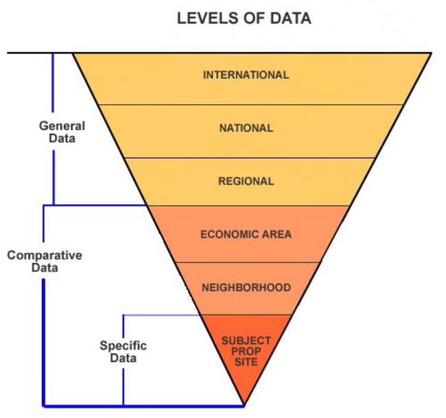
Appraisal data that will be collected and analyzed will fall into one of three categories:
- General
- Specific
- Comparative
General data is an overall category that pertains to information about the four forces (physical, economic, governmental and social) originating outside a subject property and those forces' influence on that property's value. General data provides a background basis for analysis of international, national, and regional trends that affect value.
Examples of general data would be U.S. Census publications, U.S. Labor Department employment statistics, and Colorado Division of Housing information on construction costs and housing starts.
Specific data pertains primarily to information about the site. Examples of specific data would be title and recorded information such as legal description, special assessments, zoning, easements, other public restrictions, and physical information about the site.
Comparative data consists of cost, sales, and income information on individual properties. When properly screened and confirmed, comparative data is used directly in the cost, market, and income approaches to valuing the subject property.
Examples of comparative data are vacant land sales collected within the statutory data collection period as stated in § 39-1-104(10.2), C.R.S., development costs for comparable subdivisions, and economic rental rates.
Refer to the following diagram for a graphic representation of how general, specific, and comparative data are collected for various geographic areas.
Survey of Appraisal Information Sources
Data sources of appraisal information may be divided into two categories.
- Public records
- Private sources
The major sources of public records are found in the county courthouse.
The local county clerk is a source of information on the following:
- Documentary fee information for land sales
- "Real Property Transfer Declarations" (Form TD-1000) for deeds requiring documentary fees and recorded after July 1, 1989. “Manufactured Home Transfer Declarations" for titled manufactured homes that are conveyed after July 1, 2009. These are confidential
- Copies of recorded leases
- Land descriptions from recorded plats
- Other general data about the county and cities within the county
The local planning office is a good source of information on the following:
- Zoning
- Building codes
- Traffic patterns
- Water and sewer availability
- Other important data about the property
Private sources include the following:
- A subscription to the Multiple Listing Service sold book*
- Real estate agents' records
- Publications of all types
- Media advertising
- The local Chamber of Commerce office
- Other appraisers
- Title companies
- Mortgage banks
- Property managers
- University or college studies
- Other similar sources
*Provided by the local Realtor's Association.
Neighborhoods and Economic Areas
The following subsections refer to the development of neighborhoods and economic areas.
Economic Base Analysis
Economic base analysis is the evaluation of the supply of products produced and services delivered in a given area and the demand for these products in the local, regional, national, and international markets.
In the context of the appraisal process, the supply of and demand for various goods and services affect the value of real estate in the smallest unit of analysis: the neighborhood.
Neighborhoods, as used in the appraisal process, are an essential part of valuing property. Neighborhoods are created through the collection, grouping, and analysis of data. The correct establishment and use of neighborhoods must be a part of every assessor's job.
Social, environmental, economic, and governmental forces directly affect the subject property within a neighborhood. In single-property appraisal, neighborhood analysis should begin with the definition of a neighborhood and proceed to the analysis and discussion of the relevant forces influencing the subject property at this level. The neighborhood boundary should be described in detail and its historical significance explained.
A neighborhood has direct and immediate effects on value. A neighborhood is defined by natural, man-made, or political boundaries and is established by a commonalty based on land uses, types and age of buildings or population, the desire for homogeneity, or similar factors.
Each neighborhood may be characterized as being in a stage of growth, stability, decline, or revitalization. The growth period is a time of development and construction. In the period of stability, or equilibrium, the forces of supply and demand are about equal. The period of decline reflects diminishing demand or desirability. During decline, general property use may change. Declining neighborhoods may become economically desirable again and experience renewal, reorganization, rebuilding, or restoration, marked by modernization and increasing demand.
The appraiser must analyze whether a particular neighborhood is in a period of growth, stability, decline, or revitalization and predict changes that will affect future use and value.
In mass appraisal applications, neighborhood information can be useful for comparing or combining neighborhoods or for developing neighborhood ratings, which are introduced as adjustments in mass appraisal models.
Byrl N. Boyce and William N. Kinard, authors of Appraising Real Property, 1984, Lexington Books, pp. 103-104 state:
The farther removed from the subject property the market level is, the less direct and immediate will be the effect of any change on the subject property and its value. Thus, international market forces (such as oil prices or the price of gold) or national market factors (such as the prime rate of interest or the purchasing power of the dollar) create general market conditions within which real estate values and prices are set and fluctuate along with other prices or values.
Further:
Regional market forces (such as area employment and construction volume) have a closer, more nearly direct, more nearly immediate impact on the value of the subject property and of properties which are competitive with it. Local or community market forces (e.g., local population, employment, incomes, and competition) are even closer to the subject property and influence its value even more directly. Closest of all is the neighborhood level, where any change tends to have a direct and immediate impact on the value of the subject property.
In looking at neighborhoods, the first matter that should be examined is the nature of the data involved. Data can be classified in various groupings. While some data crosses group boundaries, there are certain characteristics each group possesses that distinguish it from the others.
Examples:
| International Data | Oil Prices |
|---|---|
| National Data | Prime Interest Rate |
| Regional Data | Area Employment |
| Economic Area Data | Local Interest Rate |
| Neighborhood Data | Northwood Subdivision |
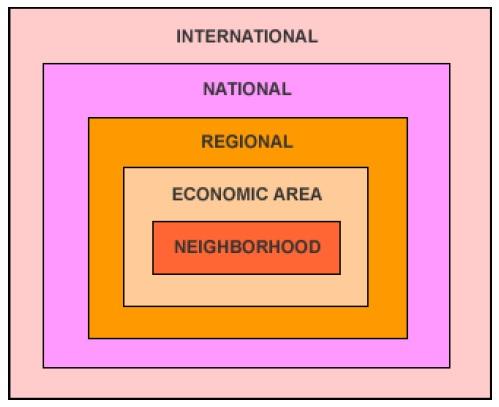
The first three groups, international, national, and regional, do not have a direct impact on a county level, with the exception of special purpose properties, e.g., breweries, mines, and cement plants.
Economic Areas
An economic area is a geographic area, typically encompassing a group of neighborhoods, defined on the basis that the properties within its boundaries are more or less equally subject to a set of one or more economic forces that largely determine the value of the properties in question. Economic areas can contain a neighborhood consisting of single family homes as well as a neighborhood consisting of multi-family properties as long as each neighborhood is subject to the same forces.
A neighborhood may be defined as the immediate environment of a subject property that has a direct and immediate impact on its value. The terms "work area" and "modeling area" are frequently associated with "neighborhood" and are considered synonymous.
Neighborhood boundaries should be used primarily as a tool when determining "similar values for similar properties in similar areas." The neighborhoods should then be combined into economic areas for sales ratio analysis, statistical analysis, or any other market data tests.
Neighborhood and, subsequently, economic area analyses are required because what occurs in the economic area has a direct and immediate impact on the values of the properties within it.
Additional terms frequently used in appraisal, but not considered synonymous to the term economic area are "subdivision," "filings," "absorption rate," and "approved plat." These terms are specific to other procedures such as "land use" or "vacant land present worth" and are not to be confused with economic areas.
Economic Area Analysis
An economic area exhibits a greater degree of uniformity than a larger area. Obviously, no group of inhabitants, buildings, or business enterprises can possess identical features or attributes, but an economic area is perceived to be relatively uniform. In addition, the neighborhoods that are grouped within the economic areas are equally subject to the same economic forces.
Economic area boundaries identify the physical area that influences the value of a subject property. Economic areas commonly contain properties of different use and types.
Therefore, the purpose in developing neighborhood boundaries is to evaluate a specific class or subclass of property within a larger economic area boundary. Neighborhoods are grouped into economic areas for purposes of statistical analysis.
In developing economic area boundaries the four forces that affect value need to be considered:
- Physical/Environmental
- Economic
- Governmental
- Social
The interaction of all the forces influences the value of every parcel of real estate in the market. Although the four forces are discussed separately, they work together to create, maintain, modify, or destroy value.
Physical/Environmental Force
By using maps and other geographic information, the appraiser can identify physical boundaries and where changes in these boundaries occur. By driving around a defined economic area, the appraiser can note the similarity in land use, structures, styles, and maintenance of the area.
Location is the most important factor of the physical forces and it has the greatest impact on valuation. Other physical factors that may be analyzed in developing neighborhood boundaries and, subsequently, economic areas include the following:
- Topography and soil
- Natural barriers to future development, such as rivers, mountains, and lakes
- Primary transportation systems, including federal and state highway systems, railroads, and airports
- The nature and desirability of the immediate area surrounding a property
Economic Force
Economic force considerations relate to the financial capacity of economic area occupants to rent or to own property, to maintain it in an attractive and desirable condition, and to renovate or rehabilitate it when needed.
Economic factors that determine the ability of residents or tenants to own and maintain properties in a competitive market include mortgage interest rates, income levels, and ownership and rental information. These economic factors should be listed to allow analysis of their contribution to value.
The economic characteristics of residents and the physical characteristics of individual properties, their neighborhood, and the larger economic area may indicate the relative financial strength of area occupants and how this strength is reflected in economic area development and upkeep.
Market characteristics considered in the analysis of economic forces include the following:
- Employment, wage levels, and industrial expansion
- The economic base for the region
- Community price levels
- The cost and availability of mortgage credit
- Availability of vacant and improved properties and new development under construction or being planned
- Occupancy rates
- The rental and price patterns of existing properties
- Construction costs
Governmental Force
Governmental actions and regulations also act as a force to influence the character of economic areas. Government factors should be listed and analyzed for their contribution to value. These government factors include local laws, regulations, taxes, and restrictions that affect neighborhoods and their economic areas by influencing the type of occupants that will be found in the area.
The government provides many facilities and services that influence and control land use patterns. The following should be listed and analyzed for possible contributions to value:
- Public services such as fire and police protection, utilities, refuse collection, and transportation networks
- Local zoning, building codes, and health codes, especially those that obstruct or support land use
- National, state, and local fiscal policies
- Special legislation that influences general property values, e.g., rent control laws, restrictions on forms of ownership such as condominiums and timeshare arrangements, homestead exemption laws, environmental legislation regulating new developments, and legislation affecting the types of loans, loan terms, and investment powers of mortgage lending institutions
- Tax burdens relative to the services provided, and special assessments
Social Force
The social force is exerted primarily through social attitudes and demographics (population characteristics) including changes in total population, the rate of family formations and dissolutions, and age distributions. An economic area's character and real property values are strongly influenced by the residents who live and work there.
Social factors are closely tied to the life cycles of neighborhoods and their economic areas. People are attracted to certain economic areas by life style, services available, price range, and convenience.
According to The Appraisal of Real Estate, 2013, 14th Edition, Appraisal Institute, page 167 (Paraphrased):
The important social characteristics that the market considers in neighborhood analysis
include:
- Population density, particularly important in commercial neighborhoods
- Occupant skill levels, particularly important in industrial or high-technology districts
- Occupant age levels, particularly important in residential neighborhoods
- Household size
- Occupant employment status, including types of unemployment
- Extent or absence of crime
- Extent or absence of litter
- Quality and availability of educational, medical, social, recreational, cultural, and commercial services
- Community or neighborhood organizations, e.g., improvement associations, block clubs, crime watch groups
Development of Economic Areas
Differences in economic area desirability often coincide with natural barriers, major streets, subdivision lines, and housing style. These differences are usually reflected in the price of land, trends in property values, and the prices for which houses of seemingly comparable physical characteristics tend to sell.
Before economic area boundaries are defined, neighborhoods should be developed for each class of property. It is possible for residential, commercial, industrial, and vacant land neighborhood boundaries to overlap.
However, neighborhood subclass boundaries cannot overlap within the same subclass. For example, the neighborhood boundary for NBHD 1, consisting of single family homes, cannot overlap into NBHD 2, which also consists of single family homes. However if NBHD 1 and NBHD 2 are equally subject to the four forces, they can both be in the same economic area.
Stratifying a class of property into homogeneous subclasses can enable the assessor to develop accurate values for property. For example, if condominium values are based only on condominium sales, the values placed on unsold condominium properties will be more reflective of the condominium market than would be the case if these values were based on a composite of all residential sales. It is also possible to stratify the subclasses of property into age, style, construction type, and quality groupings. However, the appropriate level of stratification is dependent on the number of available qualified sales and whether the number of qualified sales allows a statistically reliable estimate of value.
The development of economic areas begins first by considering the physical, economic, governmental, and social forces affecting value within neighborhoods and by considering property subclass homogeneity as discussed above. The identification of each economic area boundary can then be completed through the completion of the following steps:
- Inspect the physical characteristics of neighborhoods. Drive around the region to develop a visual sense of possible groupings of neighborhoods into economic areas, noting the degree of similarity in land uses, types of structures, architectural designs, quality, and condition. On a map of the area, note the points where these characteristics show perceptible changes and mark any physical barriers such as streets, hills, rivers, and railroads that coincide with the changes. These notes and marks establish preliminary economic area boundaries.
- Compare the preliminary economic area boundaries against the socioeconomic characteristics of the area's population and make adjustments to the boundaries taking into consideration the economic, governmental, and social forces affecting value, as well as, elements of homogeneity. Reliable data may be obtained from local chambers of commerce, universities, and research organizations. Additional information may be gathered from informal interviews with property owners, business persons, real estate professionals, and community representatives to determine the extent of an economic area.
- Review and analyze sales data within each adjusted economic area by plotting sales prices per square foot (or other unit of comparison), coded by subclass, within the adjusted economic area boundaries on a property sales map and/or by performing statistical tests such as sales ratio studies for the economic area with sales ratios coded by neighborhood. Make final adjustments to economic area boundaries with the understanding that these boundaries may change along with changes in the economic forces and factors in subsequent reappraisal years.
Examples of market analysis procedures can be found in Property Appraisal and Assessment Administration, 1990, and the Standard on Ratio Studies, 2010, both published by the International Association of Assessing Officers.
Land Subclass Analysis
Residential Land
Residential land values are based on desirability, scarcity, surroundings, restrictions, utilities, and location. The more desirable the location, the more valuable the land. Desirability is stimulated by the factors of surroundings, land use restrictions, utilities, availability of transportation, shopping facilities, schools, and churches.
Commercial Land
Commercial lands are primarily bought as investments or as income producing properties. The value of this type of land is based on the need for commercial goods and services in the economic area, availability of suitable sites to accommodate those goods and services, and reasonable access to the land by both the owner/user and potential purchasers of goods and services.
Industrial Land
Industrial lands are subject to highly specialized and intensive use analyses that are wholly dependent upon each individual owner's requirements. Industrial properties rarely sell on the open competitive market as other than unimproved sites. Each industrial property requires special analysis because of the land's individual characteristics. Each site should be studied in detail as to use, topography, shape, utility, site improvements, industrial capacity, zoning, location in relation to transportation, proximity of the labor market, and accessibility to the customer market.
"Other Agricultural" Land
Agricultural land valuations are based upon productivity formulas contained in the Colorado Constitution, statutes, and Division policy. Refer to Chapter 5, Valuation of Agricultural Lands.
"Other agricultural" lands, that are sometimes referred to as agribusiness properties when improvements are built, are primarily bought as income producing properties. As required by § 39-1-102(1.6)(b), C.R.S., the actual value of this type of land is to be based on the three approaches to appraisal based on its actual use on the assessment date. Comparison of sales of similar agribusiness properties must be used in the market approach. If the income approach is used to value this land, the income must be established based on a use similar to the actual use of the subject. This method differs from that used by the assessor to establish actual valuations of agricultural lands. Also, another difference is that personal property associated with "other agricultural" operations is not exempt. For a definition of exempt agricultural equipment refer to Chapter 5, Valuation of Agricultural Lands.
Natural Resource Leaseholds and Lands
Like industrial lands, natural resource lands are subject to highly specialized and intensive use analyses that are wholly dependent upon each individual owner's requirements. Natural resource properties rarely sell on the open competitive market. When properties are sold, they should be studied to determine if the sale price attributable to improvements and personal property can be isolated. Each natural resource property requires special analysis because the assessor's actual valuations of natural resource leaseholds and lands are, in part, established based upon statutory productivity formulas that may not reflect market value. Refer to Chapter 6, Valuation of Natural Resources.
Recommendations
The following procedures are recommended by the state board when establishing economic areas:
- Complete a written narrative describing the forces affecting the value of the properties within defined neighborhoods.
- Attach unique codes to all neighborhoods and appropriately code all properties in the county for computer access and for purposes of analysis.
- Indicate the number of properties within each neighborhood.
- Indicate the number of sales within each neighborhood.
- Draw preliminary economic area boundaries on a map by connecting the points where the physical characteristics of neighborhoods change.
- Through the analysis of economic forces and property subclass homogeneity, adjust preliminary economic area boundaries.
- Using sales prices per square foot, coded for subclass, and sales ratio analysis, with sales ratios coded by neighborhood, establish final economic areas. Physically draw final neighborhood boundaries on a map.
Requirements
Each county is required by the state board to complete the following:
- A physical map delineating economic areas resident in the county and the justification therefore. The State Board of Equalization's intent is written justification.
- The county must, through computerization, appraisal records, or other means, be able to identify each property within the economic areas.
For further information on economic area stratification, please refer to the following publications.
- Property Appraisal and Assessment Administration, 1990, International
Association of Assessing Officers. - Standard on Ratio Studies, 2010, International Association of
Assessing Officers-Assessment Standards Committee.
The Approaches to Value
Colorado statutes require that the cost, market (sales comparison), and income approaches to value be considered by the assessor when valuing land.
Within the framework of the three approaches, there are five accepted methods of valuation that may be used. These methods are as follows:
- Market (Sales Comparison) Approach
- Sales comparison method
The sales comparison method is the most reliable method of land valuation. This method first compares comparable vacant land parcels that have sold, during the selected data collection period, with subject properties, and then processes these sales prices into indicators of value by adjusting them for differences when compared to the subject properties. - Extraction or allocation method
The extraction or allocation methods are based on the principle that land has a defined relationship to the total property value. In the allocation method, a proportion of the total property value is allocated to the land. In the extraction method, the land value is extracted from sales of improved properties.
- Sales comparison method
- Cost Approach
- Anticipated use or developmental cost method
While there is no cost approach for vacant land, the anticipated use or developmental cost method is sometimes referred to as a cost method. It is used primarily where sales are limited and the land is in transition from agricultural use to residential or commercial use. The total anticipated development costs are subtracted from the anticipated sales price to indicate the value of the raw land.
- Anticipated use or developmental cost method
- Income Approach
- Capitalization of ground rent method
The capitalization of ground rent method employs the income approach. Income to the land is capitalized into an indication of value. This method is based on the premise that property value is based on the present worth of future benefits of property ownership. The market rent of the subject tract is estimated, a net income is calculated, and a capitalization rate selected. The net income is then capitalized into an indication of value by dividing the net income by the capitalization rate. - Residual (land) method
The land residual capitalization method involves estimating net income earned by a total property, establishing the cost of the building, and calculating and deducting from total net income the income attributable to the building. The remaining income attributable to the land is capitalized into an indication of value.
- Capitalization of ground rent method
Generally, the sales comparison method is preferred as it is the method that most closely approximates the effects of the market. In the absence of sales information, any of the other methods can be used to arrive at an indication of value. However, each of the other methods has drawbacks and the assessor should exercise caution when using them. Prior to using any of the above methods, vacant land sales must be discovered, collected, confirmed, and verified.
Sales Comparison Method
The sales comparison method compares the subject property to vacant land parcels that have sold within a designated time period. The comparable sales are adjusted for atypical financing, for time (date of sale), for location, and for other differences in physical characteristics between the sold property and the subject property. The adjusted sales prices are then correlated to a
value indicator representing the estimated sales price of the subject property. Application of this approach requires four steps:
- Discovery and confirmation of sales
- Selection of appropriate units of comparison
- Adjustments made to sales data
- Reconciliation of adjusted sales prices into a market indicator of the subject property's value
Assuming availability of data, this method will be the primary method used to determine land values.
Selection of Appropriate Units of Comparison
Selecting the proper unit of comparison in determining land values is critical to the use of the sales comparison method. For each zoning area or land subclass, the unit selected should be the one that best fits the market. The appraiser should always select the appropriate unit of comparison in terms of how property is bought and sold.
The most common units of comparison are as follows:
- Front foot
- Square foot
- Acres
- Site
- Units buildable
Front Foot
Use of the front foot as a unit of comparison is based upon the premise that frontage significantly contributes to value. A front foot unit is a strip of land one foot in width that lies parallel to the street and continues to the rear of the parcel. This unit is calculated by dividing the sales price of the parcel by the total frontage in feet. The front foot is generally used in the appraisal of residential and commercial land where parcels are of uniform depth, but differ in frontage.
Square Foot
The square foot unit of comparison is used for sites that typically sell for a given price per square foot of land area. Although this method is generally used for commercial sites, it can be used for residential and industrial land where the sites are irregular in shape or where frontage is not a critical factor in the salability of the parcel. This unit is calculated by dividing the sales price by the total square footage in the parcel. When using the square foot method for residential property, the assessor should be aware of the problem of surplus land valuation when the site is larger than a typical residential site. Adjustments may have to be made to account for the effect of the surplus land over and above the typical site. Refer to the Surplus Land Influence Adjustments topic found later in this section.
Acre
The acreage method is useful in the valuation of large residential tracts, rural and farm properties, large commercial tracts, and large industrial sites. Acres may be calculated by dividing the total square footage of a property by 43,560, the number of square feet in an acre.
Site
A site is defined as a parcel of land that has been improved or otherwise readied for its intended use. The site unit of comparison is used when the market does not indicate a significant difference in lot value when lots are of varying sizes. The site unit is becoming more prevalent and is found in residential subdivisions, cluster developments and planned-unit developments. In some cases, it may also be used in valuing sites located in commercial and industrial developments and parks.
Units Buildable
The unit of comparison based on units buildable is used when the market indicates that a parcel typically is sold by the number of units that are allowed to be built by zoning or land use regulations. This unit of comparison is calculated by dividing the sales price of each of the comparable sales by the number of units built on the comparable sale site. However, use of this unit of comparison is predicated on the fact that the comparable sales must have structures with the optimum number of units built as permitted by zoning regulations.
For example, apartment building sites may be sold on the basis of apartments buildable and parking lots may be sold on the basis of parking spaces rentable. The units buildable may be either a theoretical or an actual number of units. The probable number of units to be built may be different from the theoretical number permitted by zoning ordinances. Consideration should be given to market demand, set back limitations, dedications and deed restrictions, topography, height limitations, and other limiting factors.
Market Adjustments
Market adjustments may have to be made for the following:
- Adjustments for atypical financing such as below market seller financing, favorable assumed mortgages, or points paid by the seller
- Adjustments for time, i.e., trending sales to the appraisal date
- Adjustments for property characteristics, e.g., location, access, topography, soil conditions
Application of adjustments is the process of adjusting differences in the comparable sales so that they become as similar as possible to the subject property. All adjustments must be applied to the sales prices of the comparable properties. The adjusted sales prices then become indicators of value for the subject property. It is always better to adjust sales than to delete sales from the analysis. This is especially true if the number of qualified sales is limited. It is also better to gather sales from the same economic area over the full 60 months before using sales that will require a location adjustment.
Adjustment for Financing
Financing adjustments convert the sale price to current actual or market value on the date of sale. Seller participation, where financing rates are not available to the general public, and assumed leases are examples of situations specific to particular properties where sales adjustments for financing might be considered.
Adjustments for financing are rarely used in valuing property for ad valorem purposes. If a financing adjustment appears to be necessary, extreme caution should be applied when developing the financing adjustment. An example of developing adjustments for financing is shown below.
Example:
Adjustment for Financing - Below Market Interest Rate Secured
| Total Sales Price (Documentary Fee) | $12,000 |
|---|---|
| Down Payment | - $500 |
| Principal Financed | $11,500 |
| Term | 10 yrs |
| Contract rate of interest | 9% |
| Market rate of interest | 12% |
| Amortization | monthly |
| Contract Payment (9%, 10 yrs) (Column 6, Compound Interest Table) $11,500 X 0.012668 | $145.68 |
| Value of Loan (12%, 10 yrs) (Column 5, Compound Interest Table) $145.68 X 69.700522 | $10,154 |
| Down Payment (Added back in) | + $500 |
| Total Adjusted Sales Price | $10,654 |
| Rounded | $10,700 |
Note: The example above uses monthly compound interest tables, which can be found in published compound interest table listings. A good reference for complete compound interest tables is the Appraisal Institute's, Capitalization Theory and Techniques Study Guide. The study guide can be purchased by contacting the Appraisal Institute in Chicago.
The text, Property Assessment Valuation, Third Edition, International Association of Assessing Officers, Kansas City, 2010, contains only annual compound interest tables. Monthly and annual compound interest factors also can be calculated using business financial calculators.
Sales should only be adjusted for financing when both of the following circumstances exist and complete documentation requisite to the sale is available:
- The seller participates in the financing of the property to enhance its sale to the buyer, i.e., the seller does not receive the full cash proceeds from the sale at time of sale.
- The financing terms offered to and accepted by the buyer are not currently available in the open market.
The preferred method for making any market adjustment to a sale is by paired sales analysis following confirmation of the sales. A comprehensive sales confirmation program is essential for development of financing adjustments. It should be emphasized that selling prices adjusted for financing are merely value indicators and may not represent actual market value. Therefore, financing adjustments are to be used with extreme caution.
Measuring and Testing the Accuracy of Financing Adjustments
After developing adjustments for financing, the accuracy and validity of the adjustments need to be tested. Sales that have been adjusted for financing should be separately stratified for statistical analysis and the setting of values.
Sales, in which the seller receives the full sale proceeds in cash, either by way of a financial institution or directly from the buyer depending on the market, typically are the best measure of accuracy. Through sales ratio analysis, these sales will validate the financing adjustments made to the sale price if their median sales ratio compares favorably to that of the adjusted selling prices.
Through sales ratio analysis, re-sales of properties also can substantiate adjustments made to the selling prices. Re-sales from individual property owners, rather than from developers or subdividers, provide a better indication of typical market value. A separate sales ratio analysis should be performed using sale prices adjusted for financing compared to resold properties.
Results from these sales ratio studies can validate or reveal the inaccuracy of the adjusted sales data. Refer to Chapter 8, Statistical Measurements, for additional information on sales ratio and other statistical analysis techniques.
Adjustment for Time (Time Trending of Sales Data)
Most appraisal organizations, such as the Appraisal Institute (Institute) and the International Association of Assessing Officers (IAAO), recognize the need for time adjustment (trending) of sales prices to the date of appraisal.
The need for time trending is discussed in the Appraisal Institute’s reference text, The Appraisal of Real Estate, 2020, 15th Edition.
Market Conditions
Comparable sales that have occurred under different market conditions than those applicable to the subject on the effective date of the value estimate require adjustments for any differences that affect their values. A common adjustment for market conditions is made for differences occurring since the date of sale. Since the time the comparable sales were transacted, general values may have appreciated or depreciated due to inflation or deflation or to investor's changing perceptions of market conditions.
Although the adjustment for market conditions is often referred to as a time adjustment, time is not the cause of the adjustment. Market conditions that shift over time create the need for adjustment, not time itself. If market conditions have not changed, no adjustment is required even though considerable time may have elapsed.
In IAAO's text titled Property Appraisal and Assessment Administration, 1990, time adjustments are discussed.
Adjustments for Time
When price levels are changing significantly, sales prices must be adjusted for time. Separate time-adjustment factors by type of property and geographic area may be necessary, as rates of change in real estate prices often vary with these factors. The target date to which sales prices are adjusted should be the appraisal date.
The vacant land sales prices must be adjusted for time of sale to June 30th of the year preceding the year of change in level of value. This adjustment is mandatory for any length of sales data collection period used for sales analysis.
In the analysis of sales, time adjustments must always be made immediately following the deduction of personal property value included in the transaction and adjustments for financing, if any. This will establish a common reference point in time for the property characteristics adjustments.
Values tend to change unevenly depending on intended use and economic area. Because of this, time adjustments should be made within land use classes and within economic areas, if possible. When sales are scarce, the assessor must analyze the available sales in great detail to make an accurate adjustment for time.
Determination of market adjustments for time involves the use of one of the four basic techniques of time trend analysis:
- Paired Sales Analysis
- Property Re-sales Analysis
- Sales Ratio Trend Analysis
- Multiple Regression Analysis
Each of these techniques will be discussed individually in the paragraphs below. Each technique has specific advantages and disadvantages. The use of each method should be thoroughly reviewed, checked, and analyzed before any application is made to other properties.
Paired Sales Analysis
Paired sales analysis of closely comparable properties is based on the economic principles of Substitution and Contribution and the traditional sales comparison (market) approach to value. Closely comparable properties selling at different times are identified and the difference in sales prices is attributed to the effect of changes in market conditions (time).
If adjustments for physical differences between the properties are necessary, these adjustments are made before the difference due to time is measured. Adjustments for physical differences must reflect the contributory value of the difference at the time of the most recent sale.
The following data requirements are necessary to complete paired sales analysis:
- Two or more qualified/verified sales of comparable properties
At a minimum, the sales should be of the same property subclass, from the same neighborhood or economic area, and the same designated data collection period. If improved, the properties should have the same basic building design, a similar effective age, and have comparable square footages. - The date of sale for each sale including day, month, and year the transaction occurred
- Contributory value, at the time of the most recent sale, of any physical differences between the properties other than date of sale
The following steps should be used in the paired sales analysis trending factor calculation procedure:
- Collect two or more comparable properties, of the same subclass, within the same neighborhood or economic area. Adjustments have been made as appropriate for deduction of personal property value included in the transactions and for atypical financing as part of the confirmation and qualification/verification process.
- Make adjustments to the most current sales prices to account for any differences in the properties' physical characteristics. Adjustments for physical characteristics must reflect the contributory value of the differences in the property at the time of the most current sale.
- Array the adjusted sales from oldest date of sale to the most current date of sale.
- Determine a usable sales price per unit of comparison, e.g., sales price per square foot.
- Calculate the actual dollar per unit and percent change per unit between each sale.
- Divide the percentage change amount by the number of months between the sales. The resulting number is the rate of change in value for the time period between the two sales.
- Array the monthly percent change for each set of paired properties from low to high. Select the median percent change per month. The application of time adjustments, calculated by paired sales analysis, is described under the Application of Time Adjustments topic later in this section.
If it is suspected from analysis of economic area sales patterns and discussions with real estate professionals that the percent change per month is significantly different depending on the location of the property sold, different percent changes for each economic area can be calculated and applied. This approach is only reliable if a sufficient number of paired sales are used to determine the individual economic area percent changes.
The quantity and quality of sales analyzed should be extensively documented for use in valuation appeals and assessment performance analyses. An example of this technique is shown below.
Example:
Using a five-year data collection period, you were able to find four sales of properties with virtually identical physical characteristics, except for minor design and age differences. All sales were verified and adjusted, if necessary, to reflect the sales price of real property only. No financing adjustments were necessary. All sales were inspected at the time of sale.
| Parcel ID# | Sales Price | Date of Sale | Parcel Size | SP$ per sq ft |
|---|---|---|---|---|
| 3611-121-12-001 | $13,000 | 1/08 | 8,000 sq ft | $1.63 |
| 3611-121-15-002 | $10,500 | 7/10 | 7,200 sq ft | $1.46 |
| 3612-132-01-015 | $15,400 | 8/11 | 11,000 sq ft | $1.40 |
| 3614-122-05-016 | $12,400 | 5/12 | 9,100 sq ft | $1.36 |
Calculation of the time adjustment percentage is shown below.
-$0.17 difference between 2008 and 2010 divided by 2008 sales price and then divided by the number of months (30) between the two sales.
-0.17 ÷ 1.63 = -0.104 ÷ 30 mo. = -0.0035 per month
-$0.06 difference between 2010 and 2011 divided by 2010 sales price and then divided by the number of months (13) between the two sales.
-0.06 ÷ 1.46 = -0.041 ÷ 13 mo. = -0.0032 per month
-$0.04 difference between 2011 and 2012 divided by 2011 sales price and then divided by the number of months (9) between the two sales.
-0.04 ÷ 1.40 = -0.029 ÷ 9 mo. = -0.0032 per month
Note that the results from the property re-sales analysis indicates a percentage decrease, due to market conditions (time), ranging from -0.35 percent to -0.32 percent with a median of -0.32 percent. Based on the data range, a rounded median overall percentage decrease of 0.30 percent per month can be supported. In addition, since there were no sales occurring on or close to 6/30/12 in this example, the decreasing rate of decrease of 0.30 percent per month was assumed to extend to 6/30/12, the data collection trending point.
Advantages of Paired Sales Analysis
- In most counties, there generally are a sufficient number of closely comparable property sales that can be collected, qualified, verified, and used in this technique.
- Rates of change developed in this technique are relatively easy to understand and explain to taxpayers and judicial bodies.
Disadvantages of Paired Sales Analysis
- The county must accurately determine contributory value of any differences in physical characteristics between the properties that would contribute to the difference in sales prices.
- The threshold for what constitutes "closely" comparable sold properties must be set by the county prior to beginning the analysis.
- It is very difficult to reliably modify this analysis to account for nonlinear changes in value. Nonlinear changes in value are graphically represented by a curved line of best fit when sales price and date of sale are plotted on an x-y graph.
When using the property re-sales analysis to determine time adjustments, the assessor must ensure that a sufficient number of qualified/verified property re-sales are collected and analyzed to reliably measure the time trend rate of change throughout the data collection period. Comparison to time adjustments developed through sales ratio trend analysis is probably the best way to ensure reliability.
Property Re-sales Analysis
Property re-sales analysis involves analysis of two or more sales of the same property at different times. Two or more sales of the same property are identified and the difference in sales prices is attributed to the effect of changes in market conditions (time). An advantage of this technique is that possible differences due to location, design, and other physical characteristics are eliminated or reduced due to use of the same property.
If any other adjustments for changes to the property between dates of sale are necessary, these adjustments are made before the difference due to time is measured. Adjustments for differences in physical characteristics must reflect the contributory market value of the difference at the time of sale and are made to the more current resold prices.
The following data requirements are necessary to complete property re-sales analysis:
- Two or more, qualified/verified sales prices of the same property
- The date of sale for each sale including day, month, and year the transaction occurred
- Contributory market value, at the time of the more current sales, of any differences in physical characteristics in the property between dates of sale
The following steps should be used in the property re-sales analysis trending factor calculation procedure:
- Collect, qualify, and verify as many parcels as possible that have sold two or more times within the designated data collection period. Adjustments have been made as appropriate for deduction of personal property value included in the transactions and for atypical financing as part of the confirmation and qualification/verification process.
- Make any adjustment to the more current sales prices to account for any physical differences in the property between dates of sale. Adjustments for physical characteristics must reflect the contributory value of the difference at the time of sale.
- Array the adjusted sales prices from oldest date of sale to the most current date of sale.
- Determine a usable sales price per unit of comparison, e.g., sales price per square foot.
- Calculate the actual dollar change per unit and percent change per unit of comparison between each sale.
- Divide the percentage change amount by the number of months between the sales. The resulting number is the rate of change due to time for the time period between the two sales.
- Array the monthly percent change for each set of resold properties from low to high. Select the median percent change amount. The application of time adjustments, calculated by paired sales analysis, is described under the Application of Time Adjustments topic later in this section.
If it is suspected from analysis of economic area sales patterns and discussions with real estate professionals, that the percent change per month is significantly different depending on the location of the property sold, different percent changes for each economic area can be calculated and applied. This approach is only reliable if a sufficient number of paired sales are used to determine the individual economic area percent changes.
The quantity and quality of sales analyzed should be extensively documented for use in valuation appeals and assessment performance analyses.
An example of this technique applied to two sales each of three separate properties is shown below.
Example:
Using a five-year data collection period, you have found three properties that have sold twice within the data collection period. All sales were verified and adjusted, if necessary, to reflect the sales price of real property only. No financing adjustments were necessary. All sales were inspected at the time of sale and had not changed, other than for normal wear and tear, since the sale date.
| Parcel ID# | Sales Price | Date of Sale | |
|---|---|---|---|
| Property #1 | 4123-134-13-001 4123-134-13-001 | $67,000 $79,000 | 6/1/08 1/1/12 |
| Property #2 | 4123-134-15-005 4123-134-15-005 | $74,000 $80,000 | 7/1/09 3/1/11 |
| Property #3 | 4124-123-01-003 4124-123-01-003 | $49,000 $56,000 | 9/1/07 1/1/11 |
Calculation of the time adjustment percentage is shown below.
Property #1
$79,000 (1/1/12 sale) - $67,000 (6/1/08 sale) = $12,000 (43 months)
$12,000 ÷ $67,000 = 0.179 ÷ 43 mo. = +0.0042 (0.42 percent increase per month)
Property #2
$80,000 (3/1/11 sale) - $74,000 (7/1/09 sale) = $6,000 (20 months)
$6,000 ÷ $74,000 = 0.081 ÷ 20 mo. = +0.0041 (0.41 percent increase per month)
Property #3
$56,000 (1/1/11 sale) - $49,000 (9/1/07 sale) = $7,000 (40 months)
$7,000 ÷ $49,000 = 0.143 ÷ 40 mo. = +0.0036 (0.36 percent increase per month)
Note that the results from the property re-sales analysis indicate a percentage increase, due to market conditions (time), ranging from 0.36 percent to 0.42 percent with a median of 0.41 percent. Based on the data range, a rounded median overall percentage increase of 0.4 percent per month can be supported. In addition, since there were no sales occurring on or close to 6/30/12 in this example, the rate of increase of 0.4 percent per month was assumed to extend to 6/30/12, the data collection period trending point.
Advantages of Property Re-sales Analysis
- Rates of change developed from re-sales are relatively free from influences of other physical condition differences that might contribute to the difference in value between dates of sale. Unless the property has suffered excessive physical deterioration, has been extensively remodeled, or otherwise has changed between dates of sale, the difference in value is attributable to market conditions (time).
- Rates of change developed in this technique are relatively easy to understand and explain to taxpayers and judicial bodies.
Disadvantages of Property Re-sales Analysis
- Within the county, only a small number of re-sales may exist within the designated data collection period. This number may be even smaller or nonexistent for additional stratifications, e.g., economic areas.
- The county must accurately determine contributory value, at the time of sale, of physical differences between the dates of sale that would contribute to differences in the more recent sales prices.
- It is very difficult to modify this analysis to account for nonlinear changes in value. Nonlinear changes in value are graphically represented by a curved line of best fit when sales price and date of sale are plotted on an x-y graph.
When using the property re-sales analysis to determine time adjustments, the assessor must ensure that a sufficient number of qualified/verified property re-sales are collected and analyzed to reliably measure the time trend rate of change throughout the data collection period. Comparison to time adjustments developed through sales ratio trend analysis is probably the best way to ensure reliability.
Sales Ratio Trend Analysis
Sales ratio trend analysis is a market-based statistical method. It utilizes linear regression analysis to determine if time adjustments are indicated. The amount of adjustment, if any, can be calculated from the sales ratio trend analysis results. The objective of the analysis is to determine the percentage rate of change represented by the slope of the least squares trend line through the pattern of sales ratios over time.
Overall sales ratio trend analysis performed by property subclass is less precise than analysis completed by specific economic areas containing at least the recommended thirty sales needed for reliable statistical analyses. It is recommended that sale trend analysis by property subclass be undertaken only when there are insufficient numbers of sales by economic area.
For each reappraisal cycle, sales prices are adjusted to the appraisal date. When sale price-to-appraisal (S/A) ratios rather than appraisal-to-sale price (A/S) ratios are used in the analysis, an upward trend in the ratios indicates inflation; a downward trend indicates deflation. The direction and rate of change can be visualized by a line-of-best-fit drawn on a scatterplot diagram. For mass appraisal purposes, it is recommended that the rate of change be applied on a constant (straight-line) basis.
S/A ratios are plotted on the vertical (y) axis against time intervals on the horizontal (x) axis. A linear regression "line-of-best-fit" is drawn, and the slope of the line is calculated. The slope of the line will be one factor used to determine the rate of change in value per month attributable to time. The other factor will be the y-intercept, i.e., the place on the y-axis where the line-of-best-fit crosses.
In the following example, the analysis of a sample data set containing 54 sales ratios collected over an 18-month data collection period was completed. The S/A ratios are plotted against month of sale coded from 0 (oldest) to 17 (most recent). The results and a scatterplot diagram derived from the analysis follow:
Results of Sales Ratio Trend Analysis:
| No. of Observations | 54 |
|---|---|
| Sig T | 0.001 |
| Constant | 0.984 |
| X Coefficient | 0.0015 |
| No. of Observations = | The number of rows of data being analyzed in the data set |
|---|---|
| Sig T = | The significance of T statistic provides a measure of certainty as to whether the trend is valid and should be considered |
| Constant = | The y-axis intercept |
| X Coefficient = | The slope for each independent variable |
The Sig T Statistic is a statistical test that is used to evaluate the significance of a hypothesis. The hypothesis in time trending is that there is not a time trend. If the Sig T Statistic is less than 0.05, then the hypothesis is rejected and the time trend is deemed statistically significant. In other words, the appraiser can be ninety-five percent confident that a time trend should be applied. If the Sig T Statistic is between 0.05 and 0.10, the time trend is deemed “borderline” significant and other direct and indirect time trending techniques should be examined before deciding whether to apply a time trend adjustment. If the Sig T Statistic is greater than 0.10, the time trend is deemed insignificant and should not be applied.
The sales ratio trend analysis in the example utilizes non-weighted least squares regression of the base year S/A ratios over time. The regression formula calculates a mathematical trend from the ratios that is visually represented in the scatter plot diagram. Measurement of the degree of slope in the trend allows the calculation of the percentage rate of change per month or “time trend”. Since the Sig T is less than 0.05 for the property subclass, the time trend is deemed statistically significant and should be considered.
Calculation of rate of change is determined by applying the following formula:
X Coefficient (Slope) / Constant (Y Axis Intercept)
The resulting number is the rate of change per month (in decimal form) that can be used to time trend sales prices to the appraisal date.
Calculation of the time trend for the example data set is shown below:
X Coefficient / Constant = Rate of Change per Month
0.015 / 0.984 = 0.0152 or 1.52 percent increase per month
Advantages of Sales Ratio Trend Analysis
- There is less concern with stratification by property characteristics. A sales ratio reflects the relationship between the sales price and the value that exists for properties of different physical characteristics. However, stratification and analysis by subclass and location should be performed to determine if different time trends exist.
- Nonlinear (curved) rates of change can be determined using sales ratio trending. However, the methods used to determine and measure nonlinear rates of change are more complex than described here.
- Sales ratio trending is easily administered as a component of any sales confirmation program. The only data required are the previous value, sales price and sale date.
- Time trending factors determined from other trending techniques can be compared and analyzed to determine if the effect of time is accurately represented.
Disadvantages of Sales Ratio Trend Analysis
- The assessor's actual value for each sale must reflect the property characteristics for which the sales price was established.
- Another limitation to sales ratio trend analysis is the assumption that the previous year’s values reflect correct market values of the previous appraisal date.
- The distribution of sales ratios used in this analysis must be representative of properties within the analysis area. Additional analysis should be performed to ascertain the representativeness of the sales ratio trend analysis sample.
As a reminder, sales ratios used in the sales ratio analysis technique must be based on the existing actual values that have been determined for the prior general reappraisal cycle. For the reappraisal year, sales ratios should be calculated using the sales prices collected during the data collection period ending June 30 of the prior year, divided by the assessor's actual values reflecting the prior base period appraisal date.
Multiple Regression Analysis
Multiple regression analysis (MRA) is a technique for determining the influence of several independent factors, called independent variables, on a single dependent variable, usually the total market value of the property. Examples of independent variables are size in square feet, location, age, and other property characteristics.
If time of sale is one of the independent variables, its effect on market value can be estimated and an average rate of change in price levels can be extracted. For example consider the following MRA derived model.
MV (Market Value) = $10,909.93 + ($499.78 X months since sale) + ($43.10 X sq.ft.) + ($121.90 X location) + etc.
Here the independent variables include:
- Number of months since the sale occurred to the appraisal date (months since sale)
- Square footage of the property (sq.ft.)
- Location of the property (location) as a dummy variable
Each of these independent variables has a multiplier, called a coefficient. If the regression analysis determines a coefficient for number of months since sale of $499 and the average sale price is $100,000, then the average indicated rate of change is approximately 0.005 percent per month ($499 ÷ $100,000) or 6 percent per year (0.005 X 12).
It must be emphasized that this is simply an average indicated rate of change and that the actual rate of change in this model would vary from property to property depending upon the property's sale price or calculated market value. Also, this is a linear model in that every additional month from the appraisal date would add $499 to the calculated value.
More realistically, multiple regression can be used to develop nonlinear (curved) adjustments for time. And to improve accuracy of the resulting calculated market values, separate regression models can be built for different stratifications of property.
Development of MRA models is beyond the scope of these procedures. Please refer to Property Appraisal and Assessment Administration, IAAO, (1990) for additional information on MRA model building. Also recommended are IAAO Course 311 – Residential Modeling Concepts and Course 320 - Multiple Regression Analysis.
Advantages of MRA
- Regression allows for analysis of large amounts of data.
- This technique can easily manipulate data to test theories and hypotheses.
- Contributory values for many property characteristics can be tested. Those property characteristics that significantly influence value can be identified and their influence on value can be statistically verified.
- MRA can include nonlinear (curved) relationships within and between property characteristics.
Disadvantages of MRA
- MRA may produce unreliable results with small sample sizes.
- The technique is difficult to explain to taxpayers.
- To properly use all aspects of the technique requires knowledge of statistics.
- Time trends are not "decomposable", i.e., they cannot be separated from their interaction with other variables. Time trends extracted from MRA are best used as a comparison to trends developed from other time trend techniques and should not be exclusively applied outside the regression equation.
Application of Time Adjustments
Application of monthly time adjustments to sold property prices for paired sales, property resales, and sales ratio trend analysis determined monthly time adjustments are to be applied as shown in the following example.
Time adjustments should be applied to all confirmed sales using the following formula.
TASP = SP[1 + (rt)]
TASP = Time Adjusted Sales Price
SP = Sales Price
r = Time adjustment percentage decimal equivalent. This will be a negative number in a declining market.
T represents the number of months between the month of sale and the June 30th appraisal date.
In using the time adjustment technique, the assessor should be aware of the following:
- To achieve an accurate time adjustment estimate, all sales must be confirmed.
- When using two or more sales of the same property to establish time adjustments, the property must not have had any material physical change between dates of sale.
- All sale dates should be identified as occurring in the same month that the transaction occurred.
- All sales should be inspected at the time of sale to ascertain their physical characteristics.
As soon as confirmed land sales are adjusted for time, they should be plotted on land maps. Ideally, these maps would be the same maps on which zoning (land use) and economic area boundaries have been drawn. Assessors may prefer, however, to post land use and economic area boundaries on base maps and to post sales data on individual property maps that show land dimensions, shape and size.
Both the time adjusted sales price and the price per unit should be shown within the boundaries of the land sold. A standard unit price can then be developed for each street or block and shown on the land valuations map. This permits the assessor to note the location of sales and to detect price per unit patterns.
Information on making time adjustments can be found in the following publications:
- Property Appraisal and Assessment Administration, 1990, International Association of Assessing Officers.
- Property Assessment Valuation, 2010, International Association of Assessing Officers.
- Fundamentals of Mass Appraisal, 2011, International Association of Assessing Officers.
Adjustments for Differing Property Characteristics
Location Adjustments
Assuming economic areas have been properly determined, few location adjustments will be needed. If a large number of properties within an economic area need individual location adjustments, redefining the economic area boundaries may eliminate some or most of these adjustments. Economic area boundaries can be changed if they are in error or when the change is justified by economic forces and factors.
If there is a lack of economic area sales, it may be necessary to use sales from other economic areas. If additional sales are needed, the objective is to find two or more similar properties where the only difference is economic area location. Once the difference has been analyzed and converted to a dollar or percentage adjustment, this adjustment may be applied to all similar sales used from the other economic area.
Information on making locational adjustments can be found in the following publications:
- Property Appraisal and Assessment Administration, 1990, International Association of Assessing Officers.
- Property Assessment Valuation, Third Edition, 2010, International Association of Assessing Officers.
Other Physical Characteristics Adjustments
Adjustments for access, view, topography, soil types, and many other possible physical differences are included in the physical characteristic adjustment process. Like locational adjustments, some other physical characteristic adjustments can be eliminated if initial economic area boundaries are properly defined. Economic area boundaries can be changed when the change is justified by economic forces and factors.
The adjustment for physical characteristics also includes analysis and adjustment for size, shape, and corner location characteristics that may not be representative of the typical parcel under appraisal. These characteristics and influences include the following:
- Corner influence
- Depth influence
- Surplus land influence
- Irregular sizes and shapes influence
Corner Influence Adjustments
Corner influence is the degree by which land value changes for a corner lot compared to the value of an otherwise comparable inside lot. In the case of business property, the added usefulness and value of corner lots results from the accessibility of two or more streams of pedestrian traffic, additional window displays, more prominence, and availability of more light and air than inside lots.
In the past, corner influence rules or tables have been used by assessors as a guide in mass appraisal work, especially in primary and secondary retail business districts. In practice, however, these rules and tables were found not to be representative of changing market conditions. Using the values derived through such formulas alone can lead to unsound value estimates.
In some residential areas, corner lots may command lower prices than inside lots of comparable size and characteristics. The corner influence may actually be a negative factor due to the possibility of greater special assessments, lack of privacy, increased noise and dirt, added care of curb and sidewalks, and reduction in lot area by building set-back requirements for each street.
In other residential subdivisions, corner influence may be a positive factor. A corner lot may bring a premium due to the fact that a house may be faced in either of two directions or placed diagonally on the lot allowing a view of both directions and construction of a curved driveway that exits on both streets.
However, no universal rule or table applies and the assessor must look to the market for evidence of the effects of location on value. Local attitudes, land-use patterns, rent levels, and sales prices should be analyzed to find out whether corner influence exists.
When analyzing sales, the assessor should exercise caution when attempting to attribute increases or decreases in sales prices to corner influences. In many cases, the increase or decrease can be attributable to other factors such as general location, or access. In other cases, a corner influence may exist in some parts of the neighborhood, but not in others. A substantial number of sales must be analyzed to ascertain whether a corner influence exists and how much of an adjustment should be made.
For information on corner influence, refer to the following:
- Property Appraisal and Assessment Administration, 1990, International Association of Assessing Officers.
- Property Assessment Valuation, Third Edition, 2010, International Association of Assessing Officers.
Depth Influence Adjustments
Lots in the same economic area can vary in depth, even from one side of the street to the other. Usually, an increase in depth will cause an increase in value. However, the value increase may not be proportionate to the increased depth of the lot. When this is the case, depth factors should be developed as an aid to valuing lots with atypical depths. To account for all likely atypical depths, these factors are usually placed in a depth table for ease of use.
Depth factors can only be developed through an extensive analysis of market sales. It is possible that, depending on individual economic area sales analysis, each economic area could have different depth factors listed in their depth tables.
Depth factors should be used cautiously. Without good judgment they can become crutches to support unrealistic values. All facets of land valuation are based upon analysis of the market in which a particular property is located and the use of any table must be consistent with the conditions of that market.
For specific information on development of a depth table, refer to the following.
- Property Appraisal and Assessment Administration, International Association of Assessing Officers, 1990.
- Property Assessment Valuation, International Association of Assessing Officers, 2010.
Surplus Land Influence Adjustments
Any parcel of land containing one building site that has more land than is necessary for a typical building site, but cannot be separated from the site and does not have an independent highest and best use, is deemed to have surplus land. Because of the surplus land, application of a square foot or front foot unit of comparison to the entire parcel would likely result in an erroneous value. An erroneous value exists either because as land size increases beyond what is typical for a building site, people will not pay for the added amount of land at the same rate as they would pay for a typical building site, i.e., the added land does not have the same degree of utility to the prospective buyer as the typical building site; or, in the case of frontage value, the established value of a front foot does not account for the marginal increase or decrease in value due to excess land.
Surplus land may be found in residential and commercial property. An example of surplus land influence calculation is shown below.
Example:
You have confirmed several residential land parcel sales, each containing approximately 25,000 square feet at a sale price of $3,750 or $0.15 per square foot for each site. From other existing sales you determine that a typical residential building site within the neighborhood is 15,000 square feet and sells for $0.20 per square foot. What would be a reasonable estimate for surplus land adjustment and what value would you place on a parcel of 20,000 square feet?
Surplus Land Influence Calculation
| Sales Price | Parcel Size | SP per sq ft | |
|---|---|---|---|
| Oversize lot | $3,750 | 25,000 | $0.15 |
| Typical lot | -$3,000 | -15,000 | $0.20 |
| $750 | 10,000 |
Note: Sales Price attributable to surplus land ($750 ÷ 10,000 sq. ft.) = $0.075
Valuation of subject lot (20,000 sq. ft.)
| Typical site | 15,000 sq. ft. x $0.20/sq. ft. = | $3,000 |
|---|---|---|
| Surplus land | 5,000 sq. ft. x $0.075/sq. ft. = | $375 |
| Subject lot value 20,000 sq. ft. = | $3,375 |
Surplus land influence can differ greatly by economic area location. A surplus land adjustment for one economic area may not work for other economic areas. If possible, surplus land adjustments should be determined for each economic area.
Be aware that land adjustments can increase greatly if the additional land area can be separated and built on while conforming to local zoning and building codes.
Irregular Size and Shape Influence Adjustments
There are other adjustments that can be made for atypical lot sizes and irregularly shaped lots. However, these adjustments are seldom used in Colorado. If the economic area under appraisal has a substantial number of lots with varying sizes and shapes, it might be prudent to review the unit of comparison used to value the lots.
In most cases, converting to a building site or units buildable unit of comparison would allow for consideration of the atypical sizes and shapes without requiring the appraiser to spend time developing special modifiers that may be useful in only a few cases.
For information about unit modifiers for size and shape adjustments, please refer to the following:
Property Appraisal and Assessment Administration, International Association of Assessing Officers, 1990.
Calculation of Adjustment Amounts
Calculation of Adjustment Amounts Using Matched Pair Analysis
Adjustment amounts are generally determined by "matched pair" analysis of time-adjusted comparable sales. Closely comparable sales are listed in groups of two, sales prices are analyzed, and the differences in sales price between the two sales are attributable to differences in location or physical characteristics between the properties.
This process works only if the time adjusted sales are virtually identical properties except for one difference in physical characteristic or only a difference in location.
An example of this calculation is shown below.
Example:
In your sales confirmation program, you have confirmed two land sales for identical properties except for view. Sale #1 is a generally flat, residential lot with an average view of the mountains that sold for $5,000. Sale #2 is a generally flat residential lot that does not have a view of the mountains that sold for $4,500. Each lot contains one building site and both are considered a typical size for the area. All sales have been previously time adjusted.
| Sale #1 (with view) | $5,000 |
|---|---|
| Sale #2 (no view) | 4,500 |
| Sales Price attributable to view amenity | 500 |
Percentage adjustment determination
$5,000 ÷ $4,500 = 111%; difference is 11%
If a subject property or properties has a mountain view, all sales without a mountain view should be adjusted +11 percent if they are to be used to value the subject property.
Calculation of Adjustment Amounts Using Cost to Cure
Occasionally, physical differences between comparable sales and the subject property can be determined by using the cost to cure method. Using an existing cost manual, cost valuation service, or other source of construction costs, the assessor can estimate what cost would be necessary to adjust for the differences between the comparable sale(s) and the subject.
Obviously, this method cannot be used for adjustments of an intangible nature or that are not feasible to cure. Examples of this type of intangible or non-feasible adjustment would be as follows:
- View
- Location
- Topography
- Soil Conditions
- Other intangible adjustments or adjustments that cannot economically be cured
An example of a cost to cure adjustment calculation technique can be found below.
Example:
You are trying to determine an adjustment amount for lots that have a summer use only dirt road for access. You have gathered and confirmed sales of two lots that are similar to the subject lots in every way except they have gravel, all weather roads for access. The length of the access road for both the subject and the comparable is approximately 100 feet. The access road for both sales is new. You were unable to confirm any other sales of lots that had the same access problems as the subject.
Sale #1 sold for $10,000 and Sale #2 sold for $9,800. All sales have been time adjusted to the end of the data collection period.
Using your cost service manual, you determine the following linear foot cost for grading a 12' road and adding a 3" rock gravel road base similar to the road to each of the comparable properties.
| Cost of Grading to upgrade road: | $4.60 per linear foot |
|---|---|
| Add 3" Gravel road base: | $10.00 per linear foot |
| $14.60 per linear foot |
To adjust the comparable sale to account for the lack of an all-weather access road, you would deduct the replacement cost of the road from the sales price paid for each of comparable lot sales.
Sale #1: $10,000 - 1,460 = $8,540
Sale #2: $9,800 - 1,460 = $8,340
Caution should be exercised when using this cost adjustment technique. When applied properly, the cost approach usually generates the upper limit of value for property valuation. Because of economic conditions within the economic area, the market may determine that the contributory value of the improvement is less than its cost. This method should be used only when no market information is available.
Calculation of Adjustment Amounts from Other Sources
When the matched pair and cost to cure methods cannot be used because of insufficient information, the assessor must use other sources of information. However, confirmation of sales from the full five-year data collection period should occur before consideration of other sources.
One other source would be sales from other counties having similar economic conditions. If local sales are absent, sales from economically comparable counties are a good source.
Another less reliable source, to be used only as a last resort, is the soliciting of opinions from local appraisers and real estate professionals concerning the contributory values of characteristics for which adjustments are necessary.
Comparable Sale Adjustment Techniques
Adjustments to comparable land sales can be made in one of three ways:
- Adding and subtracting dollar amounts
- Adding or subtracting percentage adjustments
- Cumulative multiplication of percentages
Examples of each of these adjustment techniques are shown below.
Example: Addition/Subtraction of Dollar Adjustments
| Sales Price | $16,000 |
|---|---|
| Plus Adj for Time (+5 percent) | + 800 |
| Time Adjusted Sales Price | $16,800 |
| Plus Adj for View (+10 percent) | +1,680 |
| Plus Adj for Location (+5 percent) | +840 |
| Less Adj for Access (-5 percent) | -840 |
| Total Adjustment | +1,680 |
| Adjusted Sales Price | $18,480 |
Example: Addition/Subtraction of Percentage Adjustments
| Sales Price | $16,000 |
|---|---|
| Plus Adj for Time | x 1.05 |
| Time Adjusted Sales Price | $16,800 |
| Plus Adj for View | + 10% |
| Plus Adj for Location | + 5% |
| Less Adj for Access (-5 percent) | - 5% |
| Total Adjustment Percent | +10% |
| Adj Sales Price ($16,800 x 1.10) | $18,480 |
Example: Cumulative Multiplication of Percentage Adjustments
| Sales Price | $16,000 |
|---|---|
| Plus Adj for Time | x 1.05 |
| Time Adjusted Sales Price | $16,800 |
| Plus Adj for View | x 1.10 |
| Plus Adj for Location | x 1.05 |
| Less Adj for Access | x 0.95 |
| Total Adjustment Percent | 1.097 |
| Adj Sales Price ($16,800 x 1.097) | $18,430 |
A slightly different value may result from addition and subtraction versus multiplication of percentages, but the difference is usually not sufficient to materially affect the final valuation.
An example of the adjustment process, using both percentage and dollar amount adjustments, is shown below.
You are appraising a residential lot in a mountain subdivision. The subject property contains 2.2 acres and has an excellent view. The topography of the lot indicates steep terrain with poor access because the roads are not in good repair. The lot does not have a water well.
The appraisal date is June 30th of the year preceding the year of general reappraisal.
The following comparable sales have been confirmed as qualified sales:
Sale #1: Located in a flat part of the subdivision, this property has average view and good access. It sold ten days ago for $11,400. There is no water well on the property.
Sale #2: Located in a steep part of the subdivision, this property has average view and poor access. It sold about one year ago for $9,800. There is no water well on the property.
Sale #3: Located in a steep part of the subdivision next to the subject property, this property has excellent view and poor access. It sold about one year ago for $17,000. There is a water well on this property.
All lots are about 2 acres, wooded and all have underground electric service. All lots have access to water if wells were drilled. Only a few lots have wells at this time.
The following market factors have been determined from the market:
Time Adjustment – 5 percent increase per year.
Other Adjustments – As determined from market analysis of sales within the subdivision:
Lots with excellent view sell for $2,000 more than lots with average view.
Steep lots sell for $500 less than flat lots.
Lots with poor access will sell for $500 less than lots with good access.
A well will add $6,000 to the value of any lot.
When adjustments are made to the comparable sales prices to make them similar to the subject property, an adjustment grid is generated as shown below
Example:
| Subject | Sale #1 | Sale #2 | Sale #3 |
|---|---|---|---|
| Sales Price | $11,400 | $9,800 | $17,000 |
| Time Adj. | x 1.05 | x 1.05 | |
| Time Adj. S.P. | $11,400 | $10,290 | $17,850 |
| View excellent | + 2,000 | + 2,000 | |
| Access poor | - 500 | ||
| Terrain steep | - 500 | ||
| Well none | -6,000 | ||
| Total Adj. | + 1,000 | + 2,000 | -6,000 |
| Adj. S.P. | $12,400 | $12,290 | $11,850 |
Generally accepted appraisal theory indicates that the most reliance should be placed on the comparable sale or sales that are the most similar to the subject property and have the least adjustments. All three of the adjusted comparable sales indicate relatively tight adjusted sales price range of $12,400 to $11,850. Sale #3, by virtue of its similarity of view, access, terrain, and location next to the subject, would have the most reliance placed upon it. Therefore, the assessor’s estimate of value for the subject parcel would be approximately $12,000.
For more information on adjustment techniques, please refer to Property Appraisal and Assessment Administration, 1990, International Association of Assessing Officers.
Comparable Sales Analysis Process – Final Estimate of Value
The amount remaining after all adjustments to vacant land have been made is termed Adjusted Selling Price (ASP). If present worth valuation procedures are applicable to the property, then these additional procedures must be applied. Specific information about present worth procedures is located in Chapter 4, Valuation of Vacant Land Present Worth, later in this manual.
If present worth valuation procedures are not applicable to the property, then the comparable sales need to be reviewed, adjusted, and reconciled into a final estimate of value.
In the reconciliation process, the greatest weight is given to those sales that are the most comparable to the subject property and have the least number of adjustments. Sales that require a large number of adjustments are given less weight. If, after comprehensive analysis, all comparable sales are determined to have equal weight, the midpoint of the adjusted selling price value indications should be used.
Extraction and Allocation Methods
The extraction and allocation methods are variations of the market approach to valuation. These methods require the use of a sufficient number of recent sales to establish a trend or pattern for allocation or extraction of land values from aggregate property values.
Extraction Method
The extraction method involves determination of the contributory value of the improvements as part of the total sales price of an improved property. The balance of the sales price is attributed to the land.
When a particular area has been fully developed and there are no recent sales of vacant lots, the assessor may either apply land values established by comparable sales in very similar economic areas or may extract the value of the land from current improved property sales within the economic area. The extraction procedure involves inspection, listing, and grading the quality of the improvements and applying the appropriate cost and depreciation schedules to arrive at the depreciated value of the structure at the date of sale.
By deducting the depreciated value of the improvements from the sales price of the entire property, the assessor can obtain the extracted value of the land.
Example:
| Time Adjusted Sales Price | $45,750 |
|---|---|
| Market Value of Comparable Improvements | $36,750 |
| Extracted Land Value | $9,000 |
Example:
| Time Adjusted Sales Price | $45,750 |
|---|---|
| Replacement Cost New | $52,500 |
| Depreciation - 30% | -$15,750 |
| RCNLD | $36,750 |
| Extracted Land Value | $9,000 |
This method must be used with caution. The accuracy of the land value indicated by the use of this method depends largely on the reliability of the market value of comparable improvements. Very small errors in estimated improvement values can result in large errors in the remaining value, i.e., in the extracted value of the land. In addition, the subject land parcels and the improved properties ideally should be located in the same economic area and must have the same use.
Allocation Method
Under the allocation method, a portion of total property value is assigned to the land. Relationships between land and improvement are usually determined from the following sources:
- Site values in previous years
- Land-to-building ratios in similar neighborhoods
- Analysis of new construction on similarly classified sites
Example:
You are appraising land in a neighborhood where there are no vacant land sales. Research in residential neighborhoods similar to that of the subject property indicates that a typical land to building ratio should be about 1:4 (one part land to four parts building). Consider then, that the land is one part of the five total parts. The typical improved property sale in this neighborhood is $40,000.
Allocation of value to the land should be 1/5 or 20 percent
$40,000 x 0.20 = $8,000 Indicated land value.
Caution also must be exercised when using this method. There must be a high degree of comparability among the sites and among the properties. The properties must be located in the same economic area and be subject to the same market influences. While this method is simple, it involves several subjective assumptions and can result in an uneven pattern of land values.
Anticipated Use or Developmental Cost Method
The cost approach is generally not applicable to land valuation due to the following reasons:
- Land is a finite commodity and no replacement cost can be established for it.
- Land does not depreciate.
However, in valuing subdivisions and land developments, the cost approach may be used in estimating the value of site improvements. The anticipated use or developmental cost method, requires the appraiser to estimate the highest and best use of a tract of raw land and then to hypothetically develop the site. From the total projected sales prices of the developed lots, all costs of development are subtracted. The resulting residual value indicates the value of the raw land. Usually, the total residual value is divided by the total number of acres to get the raw land value per acre.
Site development costs include costs of utilities, streets, curb and gutter and other site improvements. These costs, along with the raw land cost (sales price) are added together to determine the total land development cost. The assessor should obtain both the raw land and site development costs from typical subdividers and land developers within the county.
Land that is changing use between raw land and the highest and best use as residential or commercial tracts can be valued using the anticipated use or developmental cost method.
In using this method, caution should be exercised for the following reasons:
- This method is highly theoretical and requires a number of estimates regarding gross lot sales revenue, sellout period, development costs, and site layout.
- The analysis required is complicated and an assumption must be made that the land’s highest and best use is for subdivision development.
- The sales of all of the lots may not be realized within one year. If a sell-out period of several years is anticipated, the sales prices likely will have to be discounted to present value using Column #5 of the compound interest tables.
- Development costs will have to be researched by the appraiser. This research may be difficult and may take a substantial amount of time to complete.
This method should only be used when comparable sales are not available.
Specific information about the anticipated use and development method can be found in the following publications.
- Property Appraisal and Assessment Administration, 1990, International Association of Assessing Officers.
- Encyclopedia of Real Estate Appraising-3rd Edition, 1978, Friedman, Edith, General Editor, Prentice-Hall Inc, Englewood Cliffs, N.J.
- Property Assessment Valuation, 2010, International Association of Assessing Officers.
Capitalization of Ground Rent Method
A useful methodology for land valuation by the income approach is the capitalization of ground rent method.
This method is based on the premise that value is determined by the present worth of future benefits of property ownership. The market rent of the subject site is estimated, a net income is calculated, and a capitalization rate selected. The net income is then capitalized into an indication of value by dividing the net income by the capitalization rate. The capitalization rate can be developed by either a market study, the band of investment method, or the summation method.
A market capitalization rate is developed through analysis of land sales that have a typical net operating income stream. Dividing the annual net operating income by the confirmed sale price results in a capitalization rate. Review of all the resulting market capitalization rates will allow the assessor to determine the rate that best fits market conditions within the county.
For the purposes of demonstration, assume that comparable rental data indicate that a subject site would rent or lease for a net operating income of $1,000 per year. A market study indicates that the proper land capitalization rate is 10 percent. The net operating income would be capitalized into value as follows:
$1,000 ÷ 10% = $10,000
Example:
A retail building is located on leased land. The land parcel is 15,000 sq. ft. and rents for $0.50 net per sq. ft. per year. Market research indicates that the economic capitalization rate is 12.5 percent.
15,000 sq. ft. x $0.50/sq. ft. = $7,500 Net Annual Rent
$7,500 ÷ 0.125 cap rate = $60,000 Indicated Land Value
Development of a capitalization rate using the band of investment method requires knowledge of the total sales price of a property, the percentage of the sales price attributable to the owner’s equity interest, the owner’s equity yield requirements and the percentages and interest rates associated with mortgage financing of the property. Using this information, a band of investment capitalization rate is determined, as shown in the following example.
Example:
| Yield or Interest | Percent of Total Capital |
|---|---|
| First Mortgage 15% (0.15) | X 55% (0.55) = 0.0825 |
| Owner’s Equity 13% (0.13) | X 25% (0.25) = 0.0325 |
| Second Mortgage 18% (0.18) | X 20% (0.20) = 0.0360 |
| Band of Investment Capitalization Rate | 100% = 0.1510 |
Summation
Development of a capitalization rate using the summation method requires the assessor to determine rate components for the safe rate, the management rate, the risk rate, and consideration for illiquidity. This method should only be used when there is a lack of market sales of comparable properties. It requires the assessor to make several subjective judgments regarding management, liquidity, and risk rate components. The summation method is described in detail in Chapter 4, Valuation of Vacant Land Present Worth.
The capitalization of ground rent method is also feasible when land is rented or leased independently of improvements. There are many instances in which commercial land is leased on a net basis. Care should be exercised to determine whether any long-term leases reflect current economic rents.
In cases where commercial land is leased on a short-term basis (one to ten years), the net rent can be directly capitalized into an indication of land value.
Residual (Land) Method
Another capitalization of income approach method is the land residual method. However, the land residual method can only be used when a building is proposed or when the existing building does not suffer from physical deterioration or functional or economic obsolescence. Therefore, this method should only be used as a last resort.
This method requires that the highest and best use of the property be estimated. The net income from the total property is estimated from comparative market income data. The replacement cost new of a building is estimated and income attributable to the building determined by multiplying the building value by the building capitalization rate. This income is then deducted from the total net income. The remaining income is attributable to the land and is capitalized into an indication of value by dividing the remaining income, i.e., the income attributable to the land, by the land capitalization rate.
Example:
You are appraising the land under a new office building. The building has a replacement cost new of $165,000 and a remaining economic life of 50 years. Economic net income to the property is $30,000. The building has not suffered any form of depreciation.
The applicable discount rate, developed from a market study is 9.5 percent. The local mill levy is 90 mills and the assessment rate is 29 percent. Calculate the land value by the land residual method.
| Discount rate | 9.5% (developed from market study) |
|---|---|
| Effective Tax rate | + 2.6% (0.29 assessment rate x 90 mills or 0.09) |
| Land Cap Rate | 12.1% Rounded 12% |
Discount/Tax rate (Land capitalization rate) = 0.12
Building recapture rate (1÷50)= 0.02
Building capitalization rate = 0.14
| Building value: | $ 165,000 |
|---|---|
| Building cap rate: | x 0.14 |
| Income attributable to building | $ 23,100 |
| Total net income | $ 30,000 |
|---|---|
| Building net income | - 23,100 |
| Land net income | $ 6,900 |
| Land net income | $ 6,900 |
|---|---|
| Land cap rate | ÷ 0.12* |
| Indicated land value | $ 57,500 |
*Land does not depreciate. Therefore, the building recapture rate is not added.
Reconciliation of Land Valuation Approaches
In reconciliation of the value estimates from the applicable valuation methods used to value any property, the appraiser takes into account the reliability of available data along with the purpose of the appraisal. Reliance by the appraiser, within the requirements of the statutes, on the most defensible method should lead to a realistic final estimate of value.
Colorado Statutory and Case Law Requirements
Colorado statutes require that the cost, market, and income approaches to value be considered in the valuation of all land except for land used for agricultural and residential purposes, oil and gas leaseholds and lands, and for producing mines. For agricultural land, an approved formula that complies with statutory language and legislative intent is to be used. This formula capitalizes net landlord income into an indication of value. For residential improved property, only the market approach is to be used. For oil and gas leaseholds and lands and producing mines, statutory formulas are used.
In determining which valuation approach or approaches should be used, Colorado case law, Montrose Properties, LTD., et al., v. Colorado Board of Assessment Appeals, et al., 738 P.2d 396 (Colo. App. 1987), affirms that the assessor must give appropriate consideration to all required approaches to value. In this case, the court concluded that “appropriate consideration” was used by an assessor when the assessor decided that insufficient information precluded the use and calculation of one or more of the required approaches. The court reasoned that appropriate consideration was used in determining that the approach(es) was not applicable. The need for appropriate consideration of the three approaches was also affirmed by the Colorado Supreme Court in Board of Assessment Appeals, et al., v. E.E. Sonnenberg & Sons, Inc., 797 P.2d 27 (Colo. 1990).
Realistically, unless sufficient income information exists for the use of the income approach, the market approach generally should be the basis for the final land valuation. To apply the market approach in the valuation of vacant land, the appraiser should be familiar with Chapter 4, Valuation of Vacant Land Present Worth. Documentation of the market approach and documentation of the non-applicability of the other approaches should be developed to satisfy the requirements of the § 39-1-103(5), C.R.S.
Information Access and Confidentiality
At the written request of any taxpayer or taxpayer’s agent, and subject to such confidentiality requirements as provided by §§ 24-72-204 and 39-5-121.5, C.R.S., the assessor must make available the data used in determining the actual value of any property owned by the taxpayer within seven (7) working days following the written request. Upon receiving the request, the assessor must immediately advise the taxpayer or agent of the estimated cost of providing the data. The intent of the statute is that the assessor immediately estimates the cost because payment must be sent to the assessor prior to providing the data. Once the data is gathered, the assessor can choose whether the data is mailed, faxed, or sent by electronic transmission to the taxpayer or agent. If the estimated cost was lower than actual costs, the assessor may include a bill with the data for any reasonable cost above the estimated cost subject to the statutory maximum. The additional costs are due and payable upon receipt of the data.
Such confidential information would include sales information obtained from the Real Property Transfer Declaration (TD-1000), the “Manufactured Home Transfer Declaration,” or other supplementary sales confirmation documents. However, the data from these documents can be combined and summarized so that individual properties or owners are not identified. These summaries can then be made available to the taxpayer as required by § 39-5-121.5, C.R.S.
It is further suggested that summaries of confidential income data for the various economic areas in the county be prepared. For example, a summary of economic area #1 would reflect gross rents ranging from $X to $Y and expenses ranging from $A to $B, etc. It is important that the assessor ensure confidentiality in all cases.
If a Computer-Assisted Mass Appraisal (CAMA) process is used to determine values, any nonproprietary data used to create the valuation model must also be made available for review by the taxpayer.
This data should be made ready for distribution prior to the taxpayer protest period. This will allow ample time to delete confidential source notations yet supply all information to which the taxpayer is entitled.
Pursuant to § 24-72-205, C.R.S., the statutory maximum is $0.25 per page unless actual costs exceed this amount. The statute delineates how the charges may be calculated. For additional information regarding this issue, refer to ARL Volume 2, Administrative and Assessment Procedures, in Chapter 1, Overview of Assessor’s Duties and Relationships.
Reference Sources for Land Valuation
Additional information about land valuation techniques, appropriate units of comparison, adjustments to sales, and other information may be obtained by consulting the following publications:
- Property Appraisal and Assessment Administration, 1990, International Association of Assessing Officers, 314 West 10th St., Kansas City, MO 64105-1616.
- The Appraisal of Real Estate, 2013, 14th Edition, Appraisal Institute, 550 West Van Buren, Chicago, Illinois 60607.
- Fundamentals of Mass Appraisal, 2011, International Association of Assessing Officers, 314 West 10th St., Kansas City, MO 64105-1616.
- Standard on Ratio Studies, 2010, International Association of Assessing Officers, 314 West 10th St., Kansas City, MO 64105-1616.
- Property Assessment Valuation, 2010, 3rd Edition, International Association of Assessing Officers, 314 West 10th St., Kansas City, MO 64105-1616.
- Improving Real Property Assessment, 1978, A Reference Manual, previously published by the International Association of Assessing Officers, 314 West 10th St., Kansas City, MO 64105-1616.
- Mini-Math for Appraisers, 1974, Irvin E. Johnson, previously published by the International Association of Assessing Officers, 314 West 10th St., Kansas City, MO 64105-1616.
Sales Confirmation Process
The sales confirmation process of discovery, collection, listing, and confirmation of sales is essential to property valuation. A sales confirmation program that is an ongoing, well organized process is the most vital element in the collection of accurate sales comparison data for the appraisal of all property. Reliable sales data are necessary to effectively apply all three approaches to value and to develop a quality assessment-ratio analysis program.
Discovery and Collection of Sales
All county assessors are required to gather sales derived from recorded deeds from the county clerk and recorder within the eighteen-month period ending on June 30th of the year prior to a year of change in the level of value pursuant to § 39-1-104(10.2), C.R.S. If a sufficient sample of qualified and confirmed sales cannot be collected from within the eighteen-month period, data must be collected from as many preceding six-month periods within the five-year data gathering period, as are necessary, to obtain sufficient qualified sales to acquire adequate comparable valuation data. In any case, all sales must be time adjusted to the end of the data gathering period. For information on how to calculate a time adjustment, please refer to Chapter 2, Appraisal Process, Economic Areas, and the Approaches to Value.
While assessors are required to collect at least eighteen months of sales data, it is recommended that the assessor consider confirming sales on a continuing, annual basis so that sales data will always be available for each five-year maximum data collection period. Availability of five years of sales will be of great help in determining market trends, deriving associated adjustment factors from analysis of those market trends, and in the development of depreciation tables.
The assessor must gather a sufficient number of confirmed/qualified sales to complete the necessary market and statistical analyses in a defensible and sound manner. The confirmed/qualified sales will also be used to substantiate adjustments for time, location, and physical condition.
The assessor should continue to gather qualified sales until a minimum of 30 such sales are available for reliable statistical analysis for a property subclass or for an economic area, if possible. If sufficient sales within the five-year period are not available within an economic area, the assessor should consider sales from other similar economic areas. Calculation of statistically significant minimum sample sizes is described in Chapter 8, Statistical Measurements.
Statutory Requirements
Property valuation must be determined by consideration of the applicable approaches to value.
Actual value determined - when.
(5)(a) All real and personal property shall be appraised and the actual value thereof for property tax purposes determined by the assessor of the county wherein such property is located. The actual value of such property, other than agricultural lands exclusive of building improvements thereon and other than residential real property and other than producing mines and lands or leaseholds producing oil or gas, shall be that value determined by appropriate consideration of the cost approach, the market approach, and the income approach to appraisal. The assessor shall consider and document all elements of such approaches that are applicable prior to a determination of actual value. Despite any orders of the state board of equalization, no assessor shall arbitrarily increase the valuations for assessment of all parcels represented within the abstract of a county or within a class or subclass of parcels on that abstract by a common multiple in response to the order of said board. If an assessor is required, pursuant to the order of said board, to increase or decrease valuations for assessment, such changes shall be made only upon individual valuations for assessment of each and every parcel, using each of the approaches to appraisal specified in this paragraph (a), if applicable. The actual value of agricultural lands, exclusive of building improvements thereon, shall be determined by consideration of the earning or productive capacity of such lands during a reasonable period of time, capitalized at a rate of thirteen percent. Land that is valued as agricultural and that becomes subject to a perpetual conservation easement shall continue to be valued as agricultural notwithstanding its dedication for conservation purposes; except that, if any portion of such land is actually used for nonagricultural commercial or nonagricultural residential purposes, that portion shall be valued according to such use. Nothing in this subsection (5) shall be construed to require or permit the reclassification of agricultural land or improvements, including residential property, due solely to subjecting the land to a perpetual conservation easement. The actual value of residential real property shall be determined solely by consideration of the market approach to appraisal. A gross rent multiplier may be considered as a unit of comparison within the market approach to appraisal. The valuation for assessment of producing mines and of lands or leaseholds producing oil or gas shall be determined pursuant to articles 6 and 7 of this title.
§ 39-1-103, C.R.S.
The assessor is allowed to use sales of comparable properties when determining actual value.
Actual value determined - when.
(5)(b) If, having considered the three approaches prescribed in paragraph (a) of this subsection (5), at the sole discretion of the assessor the use of the three approaches to value cannot accurately determine the actual value of any parcel of taxable property, or in the opinion of the assessor the application of the three approaches to value does not result in uniform, just, and equalized valuation, then the actual value thereof shall be determined by comparison of the surface use of such property with a similar surface use.
§ 39-1-103, C.R.S.
A representative body of sales is required when considering the market approach to appraisal.
Actual value determined - when.
(8) In any case in which sales prices of comparable properties within any class or subclass are utilized when considering the market approach to appraisal in the determination of actual value of any taxable property, the following limitations and conditions shall apply:
(a)(I) Use of the market approach shall require a representative body of sales, including sales by a lender or government, sufficient to set a pattern, and appraisals shall reflect due consideration of the degree of comparability of sales, including the extent of similarities and dissimilarities among properties that are compared for assessment purposes. In order to obtain a reasonable sample and to reduce sudden price changes or fluctuations, all sales shall be included in the sample that reasonably reflect a true or typical sales price during the period specified in section 39-1-104(10.2). Sales of personal property exempt pursuant to the provisions of sections 39-3-102, 39-3-103, and 39-3- 119 to 39-3-122 shall not be included in any such sample. (II) Because of the unique characteristics and limited number of oil shale mineral interests, a minimum of five arm’s-length sales of reasonably comparable oil shale mineral interests shall be required to constitute a market for purposes of utilization of the market approach to appraisal in determining the actual value of nonproducing oil shale mineral interests.
(b) Each such sale included in the sample shall be coded to indicate a typical, negotiated sale, as screened and verified by the assessor.
§ 39-1-103, C.R.S.
All qualified sales are to be used in the market analysis, but when utilizing a sales ratio analysis
there are certain statutory requirements.
Actual value determined - when.
(8)(d) In no event shall a sales ratio be established or utilized for any class or subclass of property unless and until there have been at least thirty such coded, typical sales or at least five percent of all properties in such class or subclass within the county have been sold and verified by the assessor as coded, typical sales, whichever amount is greater. When such minimum requirement has not been met but typical sales within any such class or subclass indicate that valuations in the class or subclass are too high or too low, such fact shall be reported to the state board of equalization, which board may order an independent appraisal study in such county.
§ 39-1-103, C.R.S.
The assessor is required to use sales of real property only in the valuation process.
Actual value determined - when.
(8)(f) Such true and typical sales shall include only those sales which have been determined on an individual basis to reflect the selling price of the real property only or which have been adjusted on an individual basis to reflect the selling price of the real property only.
§ 39-1-103, C.R.S.
For the purpose of determining residential documentary fees, personal property is not deducted from the sales price. If personal property value is listed on the Real Property Transfer Declaration (TD-1000), the assessor must adjust the sale price per § 39-1-103(8)(f), C.R.S. Evidence of a separate consideration for commercial or industrial personal property must be submitted prior to deduction.
Documentary fee imposed – amount – to whom payable.
(5)(a) For the purpose of determining the documentary fee in accordance with subsection (2) of this section, the amount of consideration paid for the grant or conveyance of residential real property, inclusive of liens, charges, and expenses, is the amount listed on the grant or conveyance document; except that, if there is no consideration amount listed on the grant or conveyance document or the amount listed is five hundred dollars or less, and there is a related declaration filed in accordance with section 39-14-102, then the amount of consideration paid is the total sales price listed on the declaration.
(b) In determining the amount of consideration paid for the grant or conveyance of commercial or industrial real property, inclusive of liens, charges, and expenses, the total amount of the sales price to the purchaser shall be deemed to be paid for the grant or conveyance of real property unless evidence of the separate consideration paid for personal property is submitted as shown on the purchaser’s use tax return as filed with the department of revenue or unless evidence of such separate consideration is shown on the declaration filed pursuant to the provision of section 39-14-102.
§ 39-13-102, C.R.S.
Case Law Relative to Sales Confirmation
The Colorado Supreme Court, in Board of Assessment Appeals, et al., v. E.E. Sonnenberg & Sons, Inc., 797 P.2d 27 (Colo. 1990), ruled that if evidence of comparable feedlot sales outside the county and within the relevant market is properly presented to the Board (CBOE), such evidence must be given further appropriate consideration. Based on this decision, assessors should consider comparable sales of property outside their county if it can be established that these sales can be considered to be within the subject property’s relevant market area. The court further ruled that § 39-1-103(8)(d), C.R.S., requiring 30 sales of comparable properties within a county in order to establish sales ratios for properties does not apply to the market valuation of property for property tax purposes, but rather for sales ratio determination only.
In Carrara Place, LTD., et al., v. Arapahoe County Board of Equalization, et al., 761 P.2d 197 (Colo. 1988), the Colorado Supreme Court ruled that current data could not be considered because circumstances occurred outside the base year time frame and that the base year assessment is not unconstitutional. Note: The Division suggests the phrase “base year time frame” in the decision, reflects the same concept as the phrase “data-gathering period” stated in § 39-1-104(10.2), C.R.S.
The Colorado Court of Appeals, in Platinum Properties Corporation, et al., v. Board of Assessment Appeals, et al., 738 P.2d 34 (Colo. App. 1987), ruled that property sales occurring within the base appraisal (data-collection) period, but not formally closed until after the end of the base period, cannot be excluded from consideration by the Board of Assessment Appeals or the assessor when determining the true and typical sales price of the property.
In Home Federal Savings Bank v. Larimer County Board of Equalization, 857 P.2d 562 (Colo. App. 1993) the Colorado Court of Appeals ruled that for taxation purposes, market value is the price that a willing buyer would pay a willing seller under normal economic conditions. In addition, the court further ruled that the market approach to value mandates that an appraiser determine the probable sales price for property by considering what other comparable properties actually sold for in the market place at or about the date for which the value is sought.
The Colorado Court of Appeals, in C.P. & Son, Inc. v. The Board of County Commissioners of the County of Boulder, 953 P.2d 1303 (Colo. App. 1998), ruled that case law requires assessors to follow guidelines published by the property tax administrator and that mass appraisal was an acceptable methodology for property tax purposes. The court further supported the trial court’s determination that the sale of the subject property was not an arm’s length sale based on evidence provided by the assessor. This case references various pages from this volume and Addendum 3-B, Non-Qualifying Sales.
Confirmation of Sales
The reliability of any valuation model or sales ratio study depends on the quantity and quality of its data. The findings of a sales analysis can only be as accurate as the data used in the analysis. Therefore, sales data must be collected, and adjusted to obtain valid indicators of market value.
Sometimes values in an economic area or property use class must be established on the basis of only a small number of sales. When sales are relatively scarce, it is absolutely essential that each sale be carefully analyzed for the purpose of collecting as many arm’s-length sales as possible. It is extremely important that all sales be confirmed before they are used to determine appraised values and statistical compliance.
In Colorado, a documentary fee must be paid to the county clerk and recorder on most deeds conveying title to real property unless specifically exempted by statute. The amount of the documentary fee, based on one cent for every one hundred dollars (rounded) of consideration paid, must be stamped on the deed by the county clerk and recorder as required by article 13 of title 39, C.R.S. The inclusion of a documentary fee benefits the assessor. However, blind acceptance of documentary fees on deeds without further confirmation may lead to erroneous values.
One resource available to the assessor in the sales confirmation process is the Real Property Transfer Declaration (TD-1000). Refer to Addendum 3-D, Real Property Transfer Declaration. Any conveyance document presented for recording that is subject to the documentary fee must be accompanied by a TD-1000, as required by § 39-14-102(1)(a), C.R.S. The TD-1000 includes the sale price, which should be reflected in the documentary fee, and any personal property involved in the conveyance. Other information that may be found includes the percentage of ownership conveyed, financing, and other specific issues related to the sale.
Another resource is the Manufactured Home Transfer Declaration, which after July 1, 2008, is required to accompany any titled manufactured home conveyance, §39-14-103, C.R.S. Like the TD-1000, it includes the sale price, any personal property involved in the sale, and financing. Refer to the Manufactured Home Transfer Declaration located in ARL Volume 2, Administrative and Assessment Procedures, Chapter 9, Form Standards.
To aid the assessor in the identification of non-documentary fee conveyances, please refer to Addendum 3-A, Conveyances With No Documentary Fee.
Even though the TD-1000 provides valuable information concerning the sale, it is highly recommended that the assessor mail a supplemental questionnaire to each grantee. Sales that involve new subdivisions with possible development potential, sales of vacant land where specialized financing was available, sales involving a property trade, all commercial sales, and/or sales involving any unusual activity that is known by the assessor or identified on the TD-1000 must have a supplemental questionnaire mailed to both the grantee (buyer) and grantor (seller). Oftentimes the buyers and sellers are the only ones who know the true motivating factors in a transaction.
Generally, only documentary fee sales are considered for further analysis. However, if sales are scarce, supplementary sales confirmation questionnaires should be mailed to all grantees, even for those sales recorded without a documentary fee or a TD-1000.
Many sales may be discovered where documentary fees are required and TD-1000’s have been completed, but they may not be arm’s-length transactions. Since values can be distorted by inclusion of any non-arm’s-length sales in the appraisal process, these sales should generally not be used for market analysis and should never be used in statistical analysis or to set values. Therefore, these sales should be disqualified during the sales confirmation process. Refer to Addendum 3-B, Non-Qualifying Sales.
Development of a good sales confirmation program, including a simple but comprehensive supplemental sales confirmation questionnaire that requests information not included in the TD-1000, is also essential to discover sales that are non-arm’s-length transactions.
Refer to Addendum 3-C, Additional Confirmation Letters, when the TD-1000 has not been filed, is incomplete, or in situations where additional information is needed in the confirmation process.
Data Management
Sales must be screened to identify sales that require adjustment to reflect true market value. The goal of sales screening is to obtain an adequate number of valid sales, not to find reasons to exclude sales. To maximize the number of sales available for market and statistical analysis, a sales confirmation program should include three (3) separate listings of sales. The following lists are fundamental for establishing a good confirmation program and for proper submission of collected sales for use by the assessment auditor.
Master Transaction List
The Master Transaction List (Master List) consists of property transactions occurring within the county during the selected data-gathering period. The list should include all sales regardless of documentary fee requirements. Documentation must be available to explain why certain transactions are not included in the Master List. The Master List is an accounting of the transfer of any real property interest. The Master List provides necessary data for both the Qualified List and the Non-Qualified List.
Qualified (Confirmed/Verified) List
The Qualified (Confirmed/Verified) List contains all final sales, i.e., all sales that are considered to be arm’s-length transactions after the confirmation process is complete, even if certain qualified sales have not been verified. This list is to be used for the setting of land and improvement values, building depreciation rates, market conditions (time trend), sales ratio studies, and the analysis and evaluation process.
Larger counties may be unable to verify all sales because of the number of transactions that occur each year. They should make every effort to verify sales that generate outlying sales ratios.
Smaller counties should make every effort to verify all sales. The sum of the Qualified List and the Non-Qualified List must total the number of transactions on the Master Transaction List.
Qualified Sales
Qualified sales include those sales from the Master List which remain eligible to continue in the confirmation process after:
- The elimination of sales involving transactions not requiring a documentary fee as described in title 39, article 13, C.R.S. Refer to Addendum 3-A, Conveyances With No Documentary Fee.
- The elimination of non-qualifying sales that do not meet the test of being arm’s-length transactions. Refer to Addendum 3-B, Non Qualifying Sales.
The qualified list must never include a transaction not listed on the master list.
Verified Sales
Verified sales are the sales from the Qualified List that have been determined to be typical arm’s-length transactions after having been screened for characteristics indicating nonconformity to the definition of arm’s-length. Sales are considered to be verified when data supporting their arm’s-length character has been acquired using the Real Property Transfer Declaration (TD-1000), sales confirmation questionnaires, telephone and personal confirmation interviews, and physical inspections to confirm property characteristics at the time of sale.
Most residential single family sales can be included on the verified list simply by checking if the documentary fee value matches the sale price listed on the TD-1000. For residential exceptions, and for all other classes of property to acquire a place on the verified list, either a confirmation letter or documented telephone conversation must be completed to confirm the terms of the sale and the condition of the property at time of sale. For further information regarding the TD-1000 refer to Addendum 3-D, Real Property Transfer Declaration, and article 14 of title 39, C.R.S.
Non-Qualified List
The Non-Qualified List contains all sales transactions eliminated because of no documentary fee, confirmed to be disqualified as non-arm’s-length transactions, or eliminated as transactions occurring outside the data-gathering period.
Contracts for sale shall not be included as qualified sales unless the transaction is completed, but not necessarily formally closed, during the selected data-gathering period, as required in Platinum Properties Corporation, et al., v. Board of Assessment Appeals, et al., 738 P.2d 34 (Colo. App. 1987), and the sale qualifies as an arm’s-length transaction. However, if the terms and conditions of the original agreement have been consummated, as evidenced by a deed, at some time prior to a review, appeal, or abatement hearing, the transaction is to be considered as, but is to carry no more or less weight than, any other sale. Contract for sale prices that are included as qualified sales must be time adjusted to the appropriate data collection period trending point from the day the agreement was signed.
Adjustments to Sales
Once the confirmation process has progressed beyond the elimination of non-documentary fee conveyances and the disqualification of non-arm’s-length sales referenced in Addendum 3-B, Non-Qualifying Sales, possible adjustments must be determined before sales information can be used with confidence as to its representation of market value.
Adjustments that must be considered before sales can be used with confidence include:
- Adjustment to isolate the value of real property reflected in the sale price as required by § 39-1-103(8)(f), C.R.S.
- Non-realty deduction, e.g., personal property.
Many sales include significant items of personal property. If these sales are to be used, the value attributable to the personal property must be subtracted from the sale price to obtain an “adjusted sale price.” Arbitrary, estimated or percentage adjustments for personal property should never be used. Sales must be adjusted on an individual basis to reflect real property only.
Exempt renewable energy personal property must also be deducted from residential sales prices. For more information, see ARL Volume 5, Personal Property Manual, Chapter 7, Special Issues, Renewable Energy Property Assessment.
- Non-realty deduction, e.g., personal property.
- Adjustment to correct for atypical financing arrangements or seller assisted down payments.
- Financing adjustment
Some sale prices reflect the manner of financing of the property sold. Where sale prices reflect favorable financing terms, the sale price must be adjusted. The objective of the adjustment is to arrive at a sales price that is reflective of normal conditions of sale. Favorable financed sales that are not adjusted will introduce a bias in the measures of the level of assessment. Finance adjustment instructions can be found in Chapter 2, Appraisal Process, Economic Areas and Approaches to Value.
- Seller assisted down payments
Seller assisted down payments must be declared on appropriate closing documents prior to adjusting the sales price. For more information refer to Addendum3-E, Seller Assisted Down Payments.
- Financing adjustment
- Adjustment to relate the sale price to the proper level of value.
- Time adjustment
Time adjustment must be considered as required by § 39-1-104(10.2)(d), C.R.S., that states “the level of value shall be adjusted to the final day of the data-gathering period.”
After non-realty, financing, and time adjustments have been considered, the time adjusted sales prices (TASPs) may be used to establish the valuation model. Refer to Chapter 2, Appraisal Process, Economic Areas, and the Approaches to Value.
- Time adjustment
Required Sales Data Bank
A listing of all necessary information connected with the sale must be collected, and
maintained in a sales data bank as required by § 39-14-102(4), C.R.S.
Filing of declaration – information available to county assessor.
(4) Each county assessor shall maintain a data bank consisting of information which has been derived from the declarations filed pursuant to the provisions of this article. Such information shall be used to properly adjust sales for sales ratio analysis and for determining the actual value of the real property transferred and the actual value of other real property, as well as other purposes deemed appropriate by the county assessor.
§ 39-14-102, C.R.S.
To create the sales data bank the information must include the first three items that are derived directly from the declaration, as well as, the additional items listed below.
- Parcel or identification number/legal description or property address
- Sale price
Date of sale (date of closing)
Priority of deed dates: Refer to ARL, Volume 2, Chapter 3
- Date of delivery; date title passes to the grantee (shown in the signature area of the deed).
- Acknowledgment date; date deed signed by grantor and acknowledged by a notary public.
- Date made; date deed was prepared.
- Recording date; date deed was recorded by the clerk and recorder.
If the TD-1000 is not filed with the deed, the above list should be used to identify the date the property was transferred. If the TD-1000 is available, it should be reviewed in conjunction with the deed. If the date of closing shown on the TD-1000 is significantly different than the date of delivery or the acknowledgment date shown on the deed, the date of closing should be verified. This review can be performed at the time the transfer is processed or in the sales confirmation process.
If more information is needed, contact the grantee.
- Economic area identifier
- Use or abstract code
- Assessor’s current actual value
Qualified/Unqualified status
The following additional information connected with the sale may be included in the data bank, if determined necessary.
- Book and page or reception number
- Grantor and/or grantee
- Documentary fee
- Type of conveyance
- Discretionary items, e.g., property characteristics
- Notes
For further information on sales confirmation programs and sales questionnaires, please refer
to the following:
- Fundamentals of Mass Appraisal, 2011, International Association of Assessing Officers.
- Property Appraisal and Assessment Administration, 1990, International Association of Assessing Officers.
- Standard on Verification and Adjustment of Sales, 2010, International Association of Assessing Officers.
- Standard on Ratio Studies, 2010, International Association of Assessing Officers.
Preliminary sales ratio analyses should be run using the information created from the sales data bank of the Qualified List. A sales ratio is the relationship between actual value and sale price (actual value/sale price). Any outlier sales ratios should be flagged for further investigation. Outlier sales ratios are properties with very high or low sales ratios. They may result from poor or outdated appraisals, from a non-arm’s-length transaction, or from a mismatch between the property that sold and the property that was appraised. Outliers can distort sales ratios, particularly when the number of sales is small. Outliers should be carefully reviewed to determine if an adjustment to the sale is required or if the sale must be disqualified as non-arm’s- length.
The goal of sales qualification and confirmation is to obtain an adequate number of representative sales, not to find reasons to exclude sales. If the number of representative sales is limited, it is better to adjust sales than to delete sales from the analysis.
Sales Maps
It is very beneficial to plot sales on maps of economic areas, neighborhoods or even subdivisions. Maps can be coded to indicate any or all of the following: sale price, price per square foot, price per acre, price per site, sale date, use, structure or design, or age. Codes can be by color, symbol, dots, numbers, letters, etc. Good information on sale maps can aid in selecting sales for comparison analysis, determining neighborhood boundaries and/or to identify problem areas.
Stratification of Sales
Stratification is the sorting of sales and other market data into homogeneous groups for effective sales analysis and valuation. Stratification permits analysis of mass appraisal performance within and between property groups. In addition, it provides a more complete and detailed picture of the extent and nature of appraisal performance.
Stratification of sales must take place prior to final sales analysis. Stratification for sales analysis begins by sorting sales into property class or use, i.e., vacant land, single family residential, multi-family residential, etc.
Assessors should identify all significant stratifications that are representative of property within a county. Stratifying a class of property into subclasses and economic areas will improve the accuracy of property valuations. For example, if vacant land within a particular economic area is valued based only on vacant land sales within that particular economic area, then the values placed on those properties would be more representative of the vacant land market than they would be if represented by a composite of all vacant land sales.
Once neighborhoods and economic areas have been stratified, it may be advisable to stratify the subclasses of property into subdivisions, filings, design type, age, and construction quality groupings, if a sufficient number of qualified sales exist.
When the data becomes too sparse, stratification should cease. It is recommended that stratification and analysis of a subgroup of properties should not take place unless a minimum of 30 qualified sales exist within the strata. If sufficient data exists, the analysis by strata should go beyond the economic area level.
Sampling techniques and tests of reliability, normality, bias, and other similar statistical measures will help in discovering whether additional analysis is required to determine sample size or additional stratifications. For further information regarding statistical sampling refer to Chapter 8, Statistical Measurements.
If the data supports further stratification, and the appropriate number of sales exist, stratification should take place in the following order:
- Property class, subclass, or use
- Economic area
- Neighborhood
- Subdivision/Filings
- Design type, age, construction quality
However, it should be noted that stratification by property characteristics can take place at any level, if so desired. If at any step in the stratification process a statistically reliable representative sample cannot be achieved, the process ceases. There are many major property characteristic variables available for statistical analysis of vacant land parcels. If the data exists, it should be utilized.
Physical Inspections
Physical inspections are a crucial step in verifying a sale. Utilizing the sales maps, physical inspections should be conducted for all sold properties as close to the sale date as possible in order to establish condition at time of sale and/or discovery of renovation, remodeling, additions or new construction.
Final Analysis
For those sales without TD-1000’s or supplemental questionnaires, telephone interviews or personal interviews should be attempted. Documentation of all telephone and personal interviews must be maintained. A direct interview of the buyer or seller, preferably both, is the best source to verify sales data.
When qualifying a sale, the following questions should be considered:
Does the transaction meet the definitions of market value and arm’s-length transaction
Property Assessment Valuation, 2010, IAAO, defines market value as follows:
“The most probable price which a property should bring in a competitive and open market under all conditions requisite to a fair sale, the buyer and seller each acting prudently and knowledgeably, and assuming the price is not affected by undue stimulus.”
Implicit in this definition is the consummation of a sale as of a specified date and the passing of title from seller to buyer under conditions whereby:
- Buyer and seller are typically motivated;
- Both parties are well informed or well advised and act in what they consider their best interests;
- A reasonable time is allowed for exposure in the open market;
- Payment is made in terms of cash in United States dollars or in terms of financial arrangements comparable thereto; and
- The price represents the normal consideration for the property sold, unaffected by special or creative financing or sales concessions granted by anyone associated with the sale.
The Dictionary of Real Estate Appraisal, 2022, 7th Edition, Appraisal Institute, defines arm’s-length transaction as follows:
“A transaction between unrelated parties who are each acting in his or her own best interest.”
- Is the transaction typical of the market as a whole?
- The transaction is in line with comparable sales that conform to the definition of market value.
- Is the transaction associated with one type of purchaser or specific properties?
- The market is offered to all prospective purchasers in all areas in the open market, not by tightly defined areas, locale or exclusive purchasers.
- Is the higher priced market available to all purchasers?
- Is the lower priced market available to all purchasers?
- Is the financing provided by the seller? If so, does the financing influence the price paid
- Financing, if any, is on terms generally available in the community at the specified date and typical for the property type in the locale.
- The price represents a normal consideration for the property sold, unaffected by special or creative financing or sales concessions granted by anyone associated with the sale.
Special Issues Regarding Sales Confirmation
Multiple-Level Sales (Two-Tiered Market)
Within an economic area, real estate conveyances may indicate that there are multiple levels of sale prices for similar properties. Multiple levels or distorted levels of sale prices can occur when one of two separate groups of potential purchasers are exposed to atypical marketing techniques, or other atypical conditions of sale, causing extremely high or low sales ratios within the sample. These atypical sale conditions may indicate the existence of anomalies (abnormalities) in the marketplace. Such anomalies require adjustments to be made to sale prices to correct for atypical conditions of sale before they are used as comparable properties in the valuation process.
However, atypical, multiple level, or distorted markets may also indicate sales that do not conform to the definition of arm’s-length sales. Only arm’s-length sales should be used for statistical measurement of assessment accuracy or for establishing values for an economic area. All arm’s-length sales should conform to the definition of market value.
After consideration of the definition of market value, exclusion of sales should only occur if evident marketplace anomalies remain.
The following examples of atypical sale conditions will help recognize marketplace anomalies:
- Incentives or concessions are offered to the purchasers.
- A higher priced market exists that is not available to all purchasers.
- A lower priced market exists that is not available to all purchasers.
- Transactions that involve a specific list of properties directed to one type of purchaser and are not listed on the open market.
- Sales that involve very favorable seller financing terms that are not available in the local marketplace.
- Market operations, which are highly promoted, involving video presentations, attractive brochures, and very low down payments as well as non-real estate incentives.
- Buyers that purchase property without a prior on-site inspection.
- Buyers that purchase property without being aware of existing resale market.
- Local lenders are unwilling to finance purchases of the highly promoted properties.
- There are notable occurrences of re-sales, foreclosures, or deeds in lieu of foreclosure taking place in the subject-marketing area.
The above atypical conditions of sale should be used by the assessor as criterion when making a final determination as to the inclusion or exclusion of sales used in statistical analysis or value determination. It is recommended that a supplemental questionnaire be mailed to the grantee and/or grantor to further support the inclusion or exclusion of the sale. The supplemental questionnaire should be specific to the problems that caused the anomaly.
In addition, a complete documentation process must be undertaken prior to exclusion of sales due to anomalies in the market place. A sales file should be created for each sale to be examined. All pertinent data is to be included, e.g., property record card, deed, TD-1000, and supplemental confirmation information.
If it is apparent that certain sales meet these criteria, identification of the sales in question, their associated property characteristics, and the anomaly criteria met should be completely documented prior to their removal from the qualified sales list as non-arm’s-length sales. The final determination for inclusion or disqualification is up to the discretion of the assessor. However, complete documentation is essential.
Random or arbitrary exclusion of sales is never proper. Adjustment of atypical sales to the local market should be attempted prior to exclusion of these sales.
Only the most reliable sales data, occurring within the selected data collection period, should be used in statistical analysis or for the setting of values.
Foreclosures vs. Real Estate Owned (REO) Sales
There are two situations involving the transfer of property ownership which require special consideration:
- Foreclosures.
- Re-sales of foreclosures or Real Estate Owned (REO) sales.
Foreclosures
Foreclosure is defined in The Dictionary of Real Estate Appraisal, Appraisal Institute, 7th Edition, 2022 as:
“The legal process in which a mortgagee forces the sale of a property to recover all or part of a loan on which the mortgagor has defaulted.”
In Colorado, loans for real property are typically secured by a deed of trust. The actual foreclosure procedure occurs after the trustor (borrower) defaults on the payment of the loan. The beneficiary (lender) then elects to have the property sold by the trustee, who often is both the public trustee and the county treasurer, to attempt to satisfy the terms of the loan. While this sale occurs at a public auction, the financial institution frequently accepts ownership of the property due to lack of competing bids.
Instruments that may be recorded as evidence that a foreclosure and subsequent transfer of property have occurred include a Sheriff’s Deed / Sheriff’s Confirmation Deed and a Public Trustee’s Deed / Public Trustee’s Confirmation Deed. These deeds represent the transfer of property ownership to the lender or guarantor and do not give evidence of market value. Any value represented on these types of deeds typically represents only the amount of the lien held by the lender, not the entire property value. These transactions are therefore excluded from all analyses.
A Deed in Lieu of Foreclosure may also be recorded as evidence of a foreclosure and subsequent transfer of property. A Deed in Lieu (of Foreclosure) is defined in The Dictionary of Real Estate Appraisal, Appraisal Institute, 7th Edition, 2022 as:
“A deed given by an owner or debtor in lieu of foreclosure by the lender or mortgagee.”
These deeds do not represent market value because the “seller” is, in this case, the borrower who has defaulted on the loan. The borrower is conveying the property to the lender in order to forestall a foreclosure action. Any evidence of value stated in deeds in lieu of foreclosure typically represents only the amount of the lien against the property, not the entire property value. These transactions are therefore excluded from all analyses.
The transfer of ownership of property resulting from either a foreclosure proceeding being initiated against the owner, or a deed in lieu of foreclosure, are not to be considered qualified transactions and should not be included in determining market values. Since a financial institution is involved as the “buyer,” these transactions do not meet the test of being arm’s length transactions, and should therefore be disqualified.
Re-sales of Foreclosures (REO Sales)
Real Estate Owned (REO) properties are owned by an individual, a lending institution, or a governmental or private agency as the result of a foreclosure proceeding or after the execution of a deed in lieu of foreclosure. Ownership of the property has transferred to the individual, lender, or guarantor.
Entities that may be involved as the seller (grantor) in REO sales include the following:
- Banks
- Savings and Loans
- 3. Mortgage Companies
- Private Individuals
In addition, REO sales may involve, as the seller, public or private agencies which provide loan insurance to lending institutions and acquire the property as part of the settlement of loan insurance agreements:
- Veteran’s Administration (VA)
- Housing and Urban Development (HUD)
- Private Mortgage Insurance Companies
REO sales are gathered in the same manner as other real property transfers; from recorded deeds. The minimum data-gathering period for all sales is the eighteen-month period ending on June 30th of the year prior to a year of change in the level of value. If there are insufficient sales, the data-gathering period is extended up to five years, collected in six-month periods, from that June 30th. These sales are to be confirmed. The same sales confirmation process applies to both public and private sales.
Section 20(8)(c), article X, Colorado Constitution, states in part, “Past or future sales by a lender or government shall also be considered as comparable market sales and their sales prices kept as public records.”
This means that all such sales must be considered within their appropriate data collection periods. Past sales considered shall not include sales more than 60 months old when compared to the trending point for the current data collection period.
Therefore, Housing and Urban Development (HUD) sales, or other sales by a government or lending institution, can no longer be disqualified merely because they are lender or government sales. All sales of real property by a lending institution or by a government shall be included on the Master Transaction List regardless of whether or not documentary fees for these transactions were paid to the county clerk. Such sales may be disqualified from further analysis only if the properties were sold to another lending institution or government, or if the sales do not qualify as arm’s-length transactions for reasons applied to other types of sales.
REO sales are to be used in market analysis if proper sales confirmation procedures are followed. The lack of an immediate physical inspection to confirm the condition of the property may disqualify the sale, but REO sales are initially to be considered arm’s-length transactions.
HUD and Veterans Administration (VA) properties may show low sales prices if they are sold “as is” since they may not be subject to remodeling or rehabilitation after HUD or VA has acquired the property. Lending institution owned properties typically are repaired before they are listed for sale. In either case, however, by the time the sale is confirmed, many new owners have remodeled or rehabilitated their property.
Therefore, during the sales confirmation process, property characteristics at the time of sale must be clearly established. For REO sales, particular attention must be paid to the physical condition of the property at the time of the sale. It must be determined if the property was uninhabitable, condemned, renovated, or remodeled at the time of the sale.
When a sale is confirmed with an owner, the terms of the sale and condition of the property at the time of sale must be ascertained. By the time the sale is confirmed, substantial changes may have already taken place. Then, during confirmation of the sale, the owner may inadvertently state the present condition of the property rather than the condition at the time of sale.
To avoid a situation where subsequent physical changes become associated with the sale price, it is imperative that an interior and exterior inspection of the property be made as close to the date of sale as possible. Interior and exterior inspections are necessary for the confirmation of REO sales because lower sales prices for these types of properties are typically due to additional physical depreciation. Unless an inspection is made or it can be confirmed that the expenditures were minimal, i.e., only minor repairs were necessary, a resale of a foreclosed property should not be used to establish market value.
It is very important for proper analysis that properties be stratified correctly. Stratification of similar properties, whether by economic area, design, or condition, will enable the appraiser to correctly measure the impact of all market forces on the value of property. Note that foreclosure is not a criterion for stratification. Refer to Stratification of Sales for more information regarding this topic.
Example:
A HUD sale occurs in the selected data collection period and, due to a declining market and the large number of such sales, the assessor is unable to inspect the property immediately after the sale. This sale must be added to the county’s Master Transaction List. Several months after the sale, an appraiser inspects the property and discovers the new owner has completed a great deal of remodeling since the sale. This sale is disqualified due to reason code 68 – Sale not verified before extensive remodeling or building of additional improvements or change in use. See Addendum 3-B, Non-Qualifying Sales. The sale is placed on the Non-qualified List.
As mentioned above, lending institution REO properties are typically repaired before they are listed on the market. REO properties usually become competitive with other properties offered in the marketplace by owners who are not other lending institutions or government agencies.
REO properties’ advantage is that they may carry with them the possibility of atypical financing. This financing may include no down payment (100% financing), no closing costs, and/or lower interest rates than the current market mortgage rates offered to the public. These factors make this type of property more attractive to potential buyers and may shorten the time necessary to close the sale.
VA will finance some of its properties – up to 100% of the loan amount. The biggest advantage of a VA insured loan is the owner of the property now has a mortgage that is assumable and a potential buyer of this property does not have to qualify for the loan.
HUD does not finance properties, but most of its properties are subject to Federal Housing Authority (FHA) financing. It is up to the buyer to obtain financing for a HUD owned property.
All sales must be time adjusted to the appropriate appraisal date. This is especially important for economic areas or strata that contain significant numbers of REO sales over a period of time. The goal is to value all property, whether sold or unsold, at its correct level of value as evidenced by the market on the appraisal date.
Speculative Sales
Anticipation of planned or proposed economic or political events may cause an upward surge in real property sales prices, as reflected in recorded deeds, driven by the expectation of substantial future capital gains or future profits which might be derived from the effects of these events. Examples of these anticipated events include the following:
- When a large new government facility, such as Denver International Airport, or a large private commercial or industrial manufacturing facility is planned for a known location, the volume of sales near the location typically will increase and sales prices can dramatically rise. These changes occur in anticipation of increased demand for supporting residential, commercial, or industrial property sites surrounding the operating facility.
- When ballot proposals for property use change exist, as with limited gaming, land and improved property sales activity typically will increase and sales prices can dramatically rise. These changes occur in geographic areas that would be affected by the event because there is a general perception that above normal returns on investment could be realized after passage of the ballot proposal.
When the expected economic or political event occurs as anticipated, the sales activity and price patterns constitute a normal market reaction to changes in available opportunities. However, when the expected economic or political event fails to materialize, such transactions acquire the characteristics of unfulfilled agreements for which no market value can be determined and are, therefore, rightfully disqualified in the sales confirmation process as unfulfilled agreements.
Conditions to be Met
It must be emphasized that all four of the following conditions must be met before any sale is considered for disqualification based on speculative sales constituting unfulfilled agreements.
- The anticipated event must be generally recognized as being a real possibility. Events that are generally considered to be only remotely possible do not qualify. Thus, the discussion of a possible private sector development or the circulation of initiative petitions would not, of themselves, constitute anticipated events. The actual purchase of land for the development or placement of an initiative on the ballot would constitute an anticipated event.
- There must be documentable increases in sales activity and prices. This documentation might take the form of frequency distributions of sales volumes over time, based upon the date the assessor considered the event to be recognized among the public as a real possibility, e.g., publication in the local newspaper of the sale of land for the development or the secretary of state’s acceptance of the initiative petitions. The date that the development was abandoned, or the date the ballot proposal failed, should also be documented. A data analysis period extended to the assessment date may be used to substantiate this condition, if necessary. This extension would, in the event of a ballot proposal which is defeated in November of the same year, reflect a declining volume of sales and declining prices per unit comparable, e.g., per square foot of vacant land and improved property sold during November and December.
- The anticipated event must fail to materialize. As stated before, if the anticipated event actually occurs, the increase in sales activity and rising prices constitute a normal market reaction to changes in available opportunities.
- The individual sales, which analysis indicates may be speculative sales, must be confirmed as non-arm’s-length transactions before they are disqualified.
Further Analysis
The sales confirmation procedures that have been described in this section can be useful in determining if speculative sales should be disallowed. However, the following additional conditions or situations surrounding speculative sales should also be investigated. If one or more of these circumstances occur, as confirmed by the buyer or seller, consider disqualifying the sale as a non-arm’s-length transaction:
- The sales contract contained a contingency clause that gave the buyer the option to terminate the agreement, with a loss of down payment, if the event failed to materialize.
- The buyer “walked away” from the agreement, forfeiting a down payment and any accrued equity, when the event failed to materialize.
- Financing was “owner will carry” with a substantial down payment.
- Typical lending institutions would not finance the transactions.
- A number of the transactions were cash sales in a market where financing was typical and the prices paid for properties appeared inordinately high.
IRC 1031 Real Estate Exchanges
Internal Revenue Code (IRC) §1031 Tax-Deferred Exchange may be defined as: a property exchange in which the taxpayer transfers property held for productive use in a trade or business or for investment and subsequently receives another property to be held either for productive use in a trade or business or for investment. An exchange offers the investor an opportunity to reinvest the federal capital gains, without tax liability that would normally be paid to the Internal Revenue Service (IRS). With proper planning, it is possible to avoid capital gains tax liability for as long as the exchange program remains a feature of federal tax law. There are no minimum or maximum dollar amounts. However, title to the property must be in the same name as the relinquished property. Primary residences and interests in partnerships do not qualify, and there is to be no tax-free receipt of cash by the transferor.
IRC 1031 (regulations issued in 1991) real estate exchanges are qualified sales unless disqualified due to one of the other disqualification reasons. “State non-qualification code 63 – Sale involves property trades,” or similar internal county codes, do not apply to these transactions, and after verification, these are likely qualified sales. They are not property trades in the traditional sense of the term. Straight property trades occur very infrequently.
Like-kind property must be exchanged, but like-kind property is defined as investment property, so raw land could be exchanged for apartment buildings or even second vacation homes. Like-kind property is also defined as trade or business property such as rental real estate or farm and ranch property.
The investor has 45 days from the closing on the relinquished property to identify up to three replacement properties, and 180 days from the closing (or as of the due date for the transferor’s next IRS return, including extensions, if earlier) to acquire one or more of the identified properties. More than three properties may be selected; however, their total value must not exceed 200 percent of the relinquished property value. The value of the acquired properties must exceed the value of the relinquished property and all equity from the relinquished property must be reinvested. Receiving cash or trading down is treated as boot (gain on the transfer) and taxed as capital gain.
Closing occurs separately for each of the properties and it is encouraging to note that some companies appear to be willing to share closing information. Intermediaries have copies of the closing sheets for each of the relinquished and replacement properties. The intermediaries may participate in the creation of Real Property Transfer Declarations (TD-1000), but are sometimes uncertain of how to answer the question involving property trades. Two deeds will come through the clerk’s office with documentary fees indicating the full purchase price in both cases; one for the intermediary and one for the ultimate purchaser when the exchange is complete.
Sales that exhibit the characteristics of multiple price levels, i.e., a two-tiered market, must be carefully analyzed. If deviations or departures in value from typical market transactions remain after adjustments have been made to atypical sales, the criteria for multiple level sales should be confirmed as applicable to these atypical sales prior to their disqualification as non-arm’s- length transactions.
Sales that are confirmed to be speculative sales constituting unfulfilled agreements for which no market value can be determined may be disqualified under certain conditions.
IRC 1031 (regulations issued in 1991) real estate exchanges are qualified sales unless disqualified due to one of the other disqualification reasons.
Addendum 3-A, Conveyances With No Documentary Fee
The following is a list of real estate conveyances that are exempt from the documentary fees required in article 13 of title 39, C.R.S., along with the associated codes which should be used to identify such conveyances on the Master Sales List. These conveyances ordinarily will not be shown on the Qualified List and, therefore, usually will not be used in determining values. Non-documentary fee conveyances may be used, if necessary, but they must be confirmed and verified.
| Assigned Code | Documented Reason | C.R.S. |
|---|---|---|
| 01 | Consideration of $500 or less | § 39-13-102(2)(a) |
| 02 | Deeds involving the U.S., State of Colorado, or political subdivision | § 39-13-104(1)(a) |
| 03 | Conveyance of gift | § 39-13-104(1)(b) |
| 04 | Public Trustee’s deed Public Trustee’s Confirmation deed | § 39-13-104(1)(c) |
| 05 | Treasurer’s deed | § 39-13-104(1)(d) |
| 06 | Sheriff’s deed Sheriff’s Confirmation deed | § 39-13-104(1)(e) |
| 07 | Correction (conveyance) deed | § 39-13-104(1)(f) |
| 08 | Cemetery lot conveyance | § 39-13-104(1)(g) |
| 09 | Contracts for deed of less than three years | § 39-13-104(1)(h) |
| 10 | Lease | § 39-13-104(1)(i) |
| 11 | Documents securing payment of indebtedness | § 39-13-104(1)(j) |
| 12 | Documents conveying future interests | § 39-13-104(1)(k) |
| 13 | Court decree or order | § 39-13-104(1)(l) |
| 14 | Document to transfer title resulting from death of owner | § 39-13-104(1)(m) |
| 15 | Right-of-way or easement | § 39-13-104(1)(o) |
Addendum 3-B, Reason Codes for Sales Determined to be Non-Qualified
The following is a list of real estate sales for which documentary fees are generally required. These sales must be thoroughly analyzed to determine whether they should be included on the Qualified or Non-qualified Sales Lists. If included on the Non-qualified List, they should not be used in statistical analysis or to establish values.
If a sale is determined to be non-qualified, use the appropriate Assigned Code from the following list to identify such sales on the Master Sales List.
| Assigned Code | Documented Reason |
|---|---|
| 51 | Sale involves a government agency as the buyer |
| 52 | Sale involves a public utility |
| 53 | Sale involves a charitable institution |
| 54 | Sale involves a religious institution |
| 55 | Sale involves an educational institution |
| 56 | Sale involves a financial institution as the buyer |
| 57 | Sale is between related parties |
| 58 | Sale is between business affiliates |
| 59 | Sale is to correct defect in title |
| 60 | Sale is to settle an estate |
| 61 | Sale results from judicial order or decree |
| 62 | Sales of doubtful title, e.g., quitclaims |
| 63 | Sale involves property trades |
| 64 | Sale involves multiple properties |
| 65 | Sale involves unfulfilled agreements for which no market value can be determined |
| 66 | Sale involves non-realty items of an undeterminable value |
| 67 | Sale includes a franchise or license of unknown value |
| 68 | Sale not verified before extensive remodeling or building of additional improvements or change in use |
| 69 | Sale of a partial interest, i.e., less than 100 percent of fee simple interest, in the property |
| 70 | Other __________________________________________________ |
Note: Sales disqualified under #70 must be extensively documented as to the reason the sale has been determined non-arm's-length.
Addendum 3-C, Additional Confirmation Letters
Suggested Residential Questions
Suggested Commercial Questions
Suggested Vacant Land Questions
Residential Physical Inventory Questionnaire
Addendum 3-D, Real Property Transfer Declaration
Addendum 3-D, Real Property Transfer Declaration
Real Property Transfer Declaration Instructions
(TD-1000)
Every two years, Colorado assessors must appraise all real estate in the state. Selling prices of sold properties, taken from deeds, are used extensively in the appraisal process. Because of circumstances surrounding a sale (for example, a sale between family members), some selling prices are not truly indicative of a property’s value. Appraisers typically adjust sale prices when unusual circumstances exist, or disqualify (ignore) these sales. The Real Property Transfer Declaration (TD-1000) alerts the appraiser in the Assessor’s Office to sales that may not be an indication of a property’s value.
The following is a brief explanation of the purpose of each question on the Real Property Transfer Declaration:
- Physical address or legal description of the real property sold:
This information links the sale to the assessor’s records and identifies the property’s location. - Type of property purchased:
This information allows the assessor to use one form for all uses of property and to identify the type of property purchased. - Date of Closing:
The date the property is transferred from the seller to the buyer.
Date of contract if different than date of closing:
This allows the assessor to establish the exact date of the “meeting of the minds” concerning the date the sales price was agreed upon. Even though only “closed” sales are used to set values, this information may help the assessor to eliminate atypical sales conditions. - Total sale price.
The total sale price is the most essential item of information concerning the sale, and its accuracy must be carefully scrutinized. The total sale price will sometimes differ from the recorded documentary fee. Adjustments to the sale price, often necessary before a sale can be used, are more accurate when the true price has been identified. - Was any personal property included in the transaction?
If personal property, as listed on the RPTD, was included in the sale price, the value of the personal property must be subtracted from the sale price to determine the sale price of the real property transferred. Refer to § 39-1-103(8)(a)(I) & (f) and § 39-13-102(5)(a), C.R.S - Did the total sale price include a trade or exchange?
Transactions involving trades of additional items or property should be excluded from the Assessor’s data bank of sales information whenever possible, particularly when the value of the traded property is substantial or cannot be reliably established. However, a trade under the IRS Code Section 1031 would be included in the analysis and therefore needs to be identified on the RPTD. - Was 100% interest in the real property purchased?
It is crucial to identify whether or not the sale is a fee simple transaction (100%). If it is not, the sale price cannot be considered representative of the total market value of the property. - Is this transaction among related parties or acquaintances?
It is important to know whether the buyer and seller are related individuals, business affiliates, or acquainted prior to the transaction because such sales might not reflect typical market value. - How was the property marketed and sold?
This information assists the assessor in determining where to research additional information. - Check any of the following that apply to the condition of the improvements at the time of purchase.
When determining market value, the condition of the property at the time of the sale is very important. If one or more of the items are checked, further analysis is necessary in order to establish the condition at the time of sale. - Finance questions:
When financing reflects prevailing market practices and interest rates, which is ordinarily the case with third-party financing, sales prices would not require adjustments. However, adjustments or disqualifications may be considered if the type of financing is determined atypical or non-market. - Finance questions
- Finance questions
- Finance questions
- Was an appraisal obtained regarding the transaction?
This information can be helpful in valuing commercial and complex properties where there may be limited data available. - Did the purchase price include a franchise or license fee?
If a franchise fee or license fee is included in the sale price and the amount can be substantiated, the sale price should be adjusted to reflect the sale price of the real property only. If the franchise fee or license fee that is declared on the RPTD appears to be atypical, further analysis may be necessary before the sale is used. - Did the purchase involve an installment land contract?
Title is not transferred until the final payment is made. Oftentimes the purchase price is agreed upon years prior to fulfillment of the contract and filing of the deed. Therefore, the purchase price may not be reflective of the current date on the deed. - If this was a vacant land sale, was an on-site inspection of the property conducted by the buyer prior to purchase?
If the answer to this question is no, the possibility exists of an unknowledgeable buyer. Follow up with the grantee may be necessary.
Remarks: Please include any additional information concerning the sale you may feel is important.
Property specific characteristics or external factors that caused the final sale price to decrease or increase, and have not been addressed elsewhere on this form, should be noted here. The change in price may have been based on discovery of inadequacies during an inspection, additional market research or buyer/seller motivation.
Enter the day, month, and year, and have at least one of the parties to the transaction sign the document. Please ensure the buyer or seller sign on the designated line.
Validate the form with a signature and date and printed name of signatory.
Please provide an address where all future correspondence (tax bills, property valuations, etc.) regarding this property should be mailed to, as well as a phone number and email address for assessor or treasurer communication
There will be correspondence from the assessor and treasurer that will be important to the new owner of record. Having an accurate mailing address and other means of contact through telephone or email may help the assessor and the new owner exchange relevant information. This is also helpful if the property sold is not the physical address for the owner of record. This information is kept confidential according to Colorado law.
Addendum 3-E, Seller Assisted Down Payments
State of Colorado
Real Estate Commission and Board of Real Estate Appraisers
Joint Position Statement on Seller Assisted Down Payments
Adopted July 11, 2003
The Colorado Real Estate Commission and the Colorado Board of Real Estate Appraisers have issued this Joint Position Statement to address mutual concerns pertaining to practices of real estate brokers and real estate appraisers with regard to residential sales transactions involving seller assisted down payments.
Seller assisted down payments should not be confused with seller concessions.
For example, in the Housing and Urban Development (HUD) Handbook 4155. 1 REV-4 CHG-1, HUD permits sellers (or other interested third parties such as real estate brokers, builders, etc.) to contribute up to 6% of the property’s sales price toward the buyer’s actual closing costs, prepaid expenses, discount points, and other financing concessions. HUD defines other expenses (beyond those described above), paid on behalf of the borrower, as inducements to purchase. Further, HUD considers a dollar-for-dollar reduction to the sales price for inducement to purchase before applying the appropriate loan to value ratio. Similar consideration might be appropriate on loans not involving HUD.
There are varied sources of seller assisted down payments. In some cases, the seller and buyer choose to participate in a down payment program through a charitable organization. The seller pays a fee to the charitable organization and the charity “gift funds” the down payment for the buyer. The fee paid by the seller and the amount of the down payment is not necessarily equal.
In other cases, the seller may fund the buyer’s down payment through proceeds of the sale. A buyer may offer a purchase price higher than the listing price with the provision that the seller contributes the amount of the offer over the listing price as a seller assisted down payment for the buyer.
A residential real estate transaction has a life well beyond closing and possession of the property. Accurate sales data is crucial for appraisals and comparative market analysis (CMA) work products. Both appraisers and real estate brokers can effectively work together to maintain the safeguards that accurate sold data affords.
A real estate broker can facilitate these safeguards by adherence to the following:
- Note the presence and amount of any seller paid costs (including a seller assisted down payment or fee paid to a charitable organization on behalf of the buyer) in the proper transaction documents, including the Buy-Sell Contract, Closing Statement, and Real Property Transfer Declaration.
- Utilize all available fields in the multiple listing service to record all transaction terms, including seller contributions and inducements to purchase. Sold information should be entered promptly and be specific and detailed, particularly when the sold price includes a seller assisted down payment.
- Advise buyers and seller to consult legal and tax counsel for advice on tax consequences of seller contributions and inducements to purchase.
- Cooperate with appraisers as they perform their due diligence in asking questions about sales.
An appraiser can facilitate these safeguards by adherence to the following:
- Research and confirm subject property and comparable sales, including obtaining details of the contract and financing terms.
- Research and confirm all relevant information about a transaction, including determination of seller paid costs.
- Utilize all available data search tools, including the listing history and seller contributions features of multiple listing services.
- Make appropriate adjustments to comparables with seller contributions and inducements to purchase when developing work products.
- Comply with the applicable provisions of the Ethics Rule and Standards 1 & 2 of the Uniform Standards of Professional Appraisal Practice.
- Comply with any supplemental standards required by agencies such as the Federal Housing Administration.
Concept of Present Worth Valuation
Assessors are required to consider, and when applicable, to apply the present worth valuation procedure when using the market approach to value vacant land, § 39-1-103(14)(b), C.R.S.
Present worth valuation of vacant land involves discounting. Discounting is defined in The Dictionary of Real Estate Appraisal, 7th Edition, 2022, published by the Appraisal Institute, as a procedure used to convert periodic income, cash flows and reversions into present value. Present value is based on the assumption that benefits received in the future are worth less than the same benefits received now. The objective is to determine the present worth, i.e., the actual (market) value, as of the appraisal date, of the vacant land; not its future value.
Discounting of vacant land establishes the present worth of vacant land that will not likely sell within one year. The reason for vacant land present worth valuation is to account for the time, in years, necessary to sell an inventory of vacant lots, sites, parcels, or tracts. According to Colorado law, the present worth valuation of vacant land is synonymous with actual or market value.
Refer to Definition of Terms at the end of this chapter for explanations of terms used.
It is important to note: throughout this chapter the terms “subdivider” or “land developer” are used to describe owners of vacant land. The terms are not meant to limit the application of present worth valuation procedures to specific types of land ownership. Vacant land owned by private individuals, who are neither subdividers nor developers, are considered for present worth valuation if the land otherwise qualifies.
The Colorado Supreme Court ruled that the Division’s present worth valuation procedure is an appropriate interpretation of the statutes controlling the valuation of vacant land, El Paso County Board of Equalization v. Craddock, 850 P.2d 702 (Colo. 1993). The concept of raw land value being a market value threshold below which present worth values may not decline was referenced in footnote 4, p. 707, of the case.
The Division developed a seven-step present worth valuation procedure. The objectives of the procedure are to:
- Determine the applicability of present worth valuation to the vacant land being valued
- Determine appropriate adjusted selling prices, and
- Determine the present worth value of vacant land
Present Worth Valuation Procedure
All vacant land, whether part of an approved subdivision plat, part of a Planned Unit Development (PUD), part of an environment of competing unplatted properties, or even a single, competitively isolated tract is eligible for present worth valuation. In the following procedures, the terms “lot or tract” or “lots or tracts” refer to all such land.
Applicability Present Worth Valuation
Before vacant land unadjusted selling prices (UASP) are determined, a decision is made as to whether the vacant land present worth valuation procedure applies to the subject property or properties under appraisal. The determination is made in step 2 of the present worth valuation procedure.
Step #1 Identify all lots or tracts within an approved plat or competitive environment.
Step #2 Determine the applicability of vacant land present worth valuation procedure.
Step #3 Determine the unadjusted selling price (UASP).
All steps in the present worth valuation procedure are illustrated in the following Decision Tree Analysis.
Decision Tree Analysis
Step #1 – Identify all Lots or Tracts Within An Approved Plat
“Vacant land” means any lot, parcel, site, or tract, upon which no buildings or fixtures, other than minor structures, are located, § 39-1-103(14)(c)(I), C.R.S. “Minor structures” means improvements that do not add value to the land on which they are located and that are not suitable to be used for and are not actually used for any commercial, residential, or agricultural purpose, § 39-1-103(14)(c)(II)(A), C.R.S. Vacant land may also include land that contains a non-minor structure as defined in ARL Volume 2, Administrative and Assessment Procedures, Chapter 6, Property Classification Guidelines and Assessment Percentages.
Identifying all lots or tracts within an approved plat or competitive environment is the initial step in determining the applicability of present worth valuation procedures for vacant land.
For the purpose of the procedures, approved plats are defined as:
- For subdivided land, the approved subdivision and/or its approved filings and/or its approved development tracts
- For Planned Unit Developments, the approved plan
Historically, Planned Unit Developments (PUDs), sometimes known as Planned Developments (PDs), are approved plats for the purpose of determining the applicability of present worth valuation. Sometimes these terms are used in a general way to describe zoning. If these terms are used to describe zoning, they are not an approved plat for the present worth valuation procedure.
An approved plat for subdivided land may include one or all filings within the subdivision. A single approved plat may include multiple uses. Commercial and industrial lots or tracts may exist along with residential lots or tracts within the boundaries of the approved plans for Planned Unit Developments.
If separate portions, phases or filings of a subdivision are approved at different times, then each becomes a separate approved plat and absorption calculations for each approved plat are required. To meet the definition of an approved plat, a plat must complete the entire typical approval process of the appropriate governmental entity.
For example, a plat was approved in its entirety on February 1st. The plat includes 115 single family residential lots, 76 townhome lots, and 3 large commercial lots. This one approved plat contains 194 buildable sites. Absorption calculations should be based on an original count of 194 lots. It would be contrary to Colorado law to use separate absorption calculations for the residential, townhome, and commercial lots.
For unplatted land, discounting is based on the environment of a group of competing properties, e.g., multiple contiguous tracts of land of 35 acres or more in size that do not need subdivision approval. Unplatted land can be any tract of land with an established boundary and legal description, and is typically described by section or tracts.
Step #2 – Applicability of Vacant Land Present Worth Procedure
Under § 39-1-103(14)(c)(I), C.R.S., all vacant land is eligible for present worth discounting. As part of the sales verification process, a determination is made as to whether the present worth valuation procedures are applicable to the subject property or properties.
The criteria for determining if present worth valuation is applicable are:
- The procedures are only applied to vacant land.
- Less than 80 percent of the buildable lots, tracts, sites, or parcels within an approved plat or competitive environment have been sold.
- In situations where mixed use has been approved and lot lines are established within a single approved plat, each lot is counted toward the 80 percent sellout threshold regardless of size or use.
- Lots or tracts that have legal or physical no-build restrictions should not be included in the original number of lots or tracts when determining the 80 percent sellout thresholds. These lots or tracts are typically never part of the developer’s “marketable” inventory, and will never be sold. Such lots or tracts, while never available to the open market or subject to present worth valuation, are valued with consideration given to their no-build restrictions. Lots or tracts which might have legal and/or physical no-build restrictions include the following:
- Open space lots or tracts that are required in a subdivision plan before building permits are issued
- Greenbelt lots or tracts that are permanently incorporated within a subdivision plan
- Lots or tracts unbuildable due to city or county building or zoning requirements
- "Out lots” that are adjacent to buildable lots; but due to their size or access problems, are effectively unbuildable
Only sales or long-term leases of lots to “end users” reduce the vacant land inventory and therefore, count toward the 80 percent sellout threshold. “End users” are those parties who intend to, are expected to, or have done one of the following:
- Construct improvements on the vacant lots for themselves or have begun construction of improvements, such as speculative homes, for others
- Purchase improvements constructed by builders for them
- Use the vacant land in conjunction with other improved property under the same ownership
- Purchase the vacant land for investment and intend to withhold the land from the open-market for an extended period of time
NOTE: Since sales to “end users” reduce the vacant land inventory, these sales are used for all absorption calculations, including the 80 percent sellout threshold, absorption rate, and absorption period.
- Bulk lot sales to another subdivider or land developer do not count toward the 80 percent sellout threshold. When a land developer legally transfers ownership of vacant lots in an approved subdivision plat to another land developer, there is no change in the percentage of lots or tracts sold, unless the land is resubdivided or replatted and the number of lots within the original subdivision changes.
- If a replat or resubdivision occurs and the intent of the original subdivision is substantially altered, as with a change in density or zoning, then two approved plats would exist and the total lot counts, absorption rates and periods, and the 80 percent sellout thresholds are recalculated.
- Replats or resubdivisions, which do not substantially alter the intent of the original subdivision, such as a lot line vacation, only require a recalculation of the total number of lots within the original approved plat.
- The absorption period for an approved plat or competitive environment is calculated to be more than twelve months. Absorption periods of more than twelve months are rounded up to the next whole number, so a minimum absorption period of two years is required at each change in level of value. The absorption period represents:
- the years remaining until the approved plat or competitive environment is 100% sold-out or
- the required number of years for a single, competitively isolated tract to sell to an end user.
- The application of present worth valuation procedures produces a value greater than current raw land value as defined in these procedures.
Step #3 – Determine Unadjusted Selling Prices (UASP)
Determining unadjusted selling prices (UASP) is essential to begin the sales adjustment process.
For vacant land the UASP is developed from analysis of data from the following sources:
- The retail selling price listing provided by the developer, subdivider, or property owner at the end of the data collection period.
The selling price is requested in the Vacant/Subdivision Land Questionnaire mailed each year to developers. - Confirmed arm’s-length sales of similar lots or tracts within the subdivision or its filings during the data collection period.
- Sales of other similar lots or tracts by other developers or subdividers within competitive environments or approved subdivisions inside or outside the county during the data collection period. [For direction on using sales outside the county see Board of Assessment Appeals, et al., v. E.E. Sonnenberg & Sons, Inc., 797 P.2d 27 (Colo.1990)]
The UASP is generally the price shown on the Real Property Transfer Declaration (TD-1000) or, if no TD-1000 is filed, on a supplementary confirmation questionnaire. If no supplementary questionnaire is returned, then the documentary fee sales price is used, assuming that the sale is otherwise qualified. However, the UASP should not fall below the most comparable current raw land value.
Future projections of sales prices need not be made by assessors due to the following reasons:
- For the purpose of the procedure, site values during the current data-gathering period are assumed to remain stable over time.
- Since assessing officers in Colorado are required to review vacant land present worth procedures for each change in level of value, modifications to selling prices are made every other year.
The only change required in intervening years, other than for an unusual condition, is to reduce the absorption period by one year. Then, recalculate the present worth actual value for the intervening year using the present worth factor for the modified absorption period. The sellout percentage and absorption rate calculations remain unchanged, unless a substantial resubdivision has occurred. For absorption periods calculated to be two years at a change in level of value, the absorption period will be one year in an intervening year.
EXCEPTION: If the number of sales within the approved plat, for the 12 months following the current appraisal date, is less than the absorption rate per year calculated for the plat, the absorption period may be left unchanged.
- Projection of future market activity is highly speculative.
Determining Appropriate Adjusted Selling Prices
Reviewing steps 4 through 6 (as shown on the decision tree), they are identical whether or not present worth valuation is applicable.
Step #4 Deduct for nonrealty value included in the sale price.
Step #5 Deduct unincurred direct development costs included in the sale price. The costs are for items not installed as of the assessment date, but included in the sales price.
Step #6 Make market adjustments to determine the adjusted selling price (ASP).
Step #4 - Deduct for Nonrealty Value Included in the Sale Price
By removing all nonrealty items, deductions are made to comparable properties’ unadjusted selling prices (UASP) to achieve the correct real property market value, or actual value of the real property.
Isolation of realty is accomplished prior to making any financing or property characteristic adjustments for differences between the comparable property sales and the subject property.
Example:
Deduction of the market value for nonrealty items to determine the price paid for the real property portion of the sales price
| Total Sales Price (documentary fee and TD-1000) | $40,000 |
|---|---|
| Deduction - Less Nonrealty Item (Fishing Club Membership included in purchase price) | - 7,500 |
| Total Adjusted Sales Price | $32,500 |
Step #5 - Deduct Unincurred Direct Development Costs in the Sale Price
Deductions are then made for any unincurred direct development costs. These are the costs of site improvements and direct construction costs that were included in the sales price, but were not installed as of the assessment date.
Statute requires that adjustments be made for unincurred direct costs of development before making market adjustments to vacant land sales for cash equivalency, for time, and for differing property characteristics.
Actual value determined - when.
(14)(b) The assessing officers shall give appropriate consideration to the cost approach, market approach, and income approach to appraisal as required by the provisions of section 3 of article X of the state constitution in determining the actual value of vacant land. When using the market approach to appraisal in determining the actual value of vacant land as of the assessment date, assessing officers shall take into account, but need not limit their consideration to, the following factors: The anticipated market absorption rate, the size and location of such land, the direct costs of development, any amenities, any site improvements, access, and use. When using anticipated market absorption rates, the assessing officers shall use appropriate discount factors in determining the present worth of vacant land until eighty percent of the lots within an approved plat have been sold and shall include all vacant land in the approved plat. For purposes of such discounting, direct costs of development shall be taken into account. The use of present worth shall reflect the anticipated market absorption rate for the lots within such plat, but such time period shall not generally exceed thirty years. For purposes of this paragraph (b), no indirect costs of development, including, but not limited to, costs relating to marketing, overhead, or profit, shall be considered or taken into account (emphasis added) .
§ 39-1-103, C.R.S.
Lump sum dollar adjustments, rather than percentage adjustments, should be used. However, lump sum dollar adjustments should be carefully documented and compared to the adjusted selling price (ASP) of comparable completed lots or tracts to avoid errors in valuation.
For present worth procedures, the vacant land value reflected in the ASP must not fall below the most comparable value of raw land.
Development costs are divided into two categories:
- Direct development costs
- Indirect development costs
Direct Development Costs:
- Curbs and Gutters Streets
- Culverts
- Sanitary and Drainage Sewer Facilities
- Street Lighting
- Utility Easements & Hookup
- Utilities Installation
- Site Preparation and Grading
- Sidewalks
- Environmental Compliance Costs
- Soil Tests
- Engineering and Surveying Costs
- Permits, Fees (Including Tap Fees) and Performance Bond Costs
- Insurance Directly Related to Development Construction
- Greenbelt and Common Area Development including Landscaping
Indirect Development Costs*:
- Sales Marketing Costs
- Sales Commission Costs
- Guest Generation Costs
- Entrepreneurial Profit
- Owners Insurance Costs
- Project Financing Costs
- Developer/Subdivider Profit
- Holding Costs
- Sales and General
- Administrative Overhead
- Taxes
- Professional Services
- Warranties
* Deductions not allowed pursuant to § 39-1-103(14)(b), C.R.S.
Step #6 - Market Adjustments to Determine Adjusted Selling Price
Since comparable sales are seldom exactly like the subject property, there will be differences to adjust for when making market comparisons. The market adjustments result in the adjusted selling price (ASP).
Market adjustments made for nonrealty items included in the sale are accounted for in Step # 4. The remaining considerations: (1) cash equivalency, (2) market conditions (time), (3) location, and (4) physical characteristics, are summarized into three categories:
- Cash Equivalency: Adjustments are required for atypical financing or sales concessions
- Time: Adjustments for time, i.e., adjusting sales to the appraisal date
- Property Characteristics: Adjustments for property characteristics, e.g., location, access, topography, soil conditions
Market adjustment is the process of adjusting differences in the comparable sales so that they become as similar as possible to the subject property. Adjustments are applied to the sales prices of the comparable properties. The adjusted sales prices then become indicators of value for the subject property.
If the number of valid sales is limited, it is better to adjust sales than to delete sales from the analysis.
Note: It is usually better to gather sales from the full 60-month allowable data collection period and time adjust them to the end of the current data collection period, before using sales that will require a location adjustment.
Refer to Chapter 2, Appraisal Process, Economic Areas, and the Approaches to Value for a complete discussion of how comparable properties are identified and how these adjustments are made.
Adjustments to sales prices should be carefully analyzed and documented before use. The vacant land value reflected in the ASP must not fall below the actual value of the most comparable raw land.
Step #7 - Apply Present Worth Procedures
Determining Present Worth of Vacant Land
The market absorption (sellout) period and discount rate are determined. Both are described under Sales Comparison Method found later in this chapter.
All pertinent information, approved plat or competitive environment, the unadjusted selling price, adjusted selling price, and present worth calculations shall be documented, § 39-1-103(5)(a), C.R.S.
Raw Land Value
Vacant land present worth actual value must never drop below the actual value of the most comparable raw, undeveloped vacant land as of the appropriate level of value.
According to The Dictionary of Real Estate Appraisal, 7th Edition, 2022, raw land is, “land that is undeveloped; land in its natural state before grading, draining, subdivision, or the installation of utilities.”
The Division policy of “raw land value establishing market value when present worth valuation procedures result in a lower value” is the control to ensure that mistakes in application of present worth procedures do not result in the actual value falling below market value as of the appraisal date. Should "discounted vacant land value” drop below market value, inequity in the valuation of vacant land would exist.
The policy is applicable to each level in the valuation process: the unadjusted sale price (UASP), the adjusted sale price after-market adjustments (ASP), and actual value after applying present worth valuation procedures.
Raw land is typically appraised on a per-acre basis although it may be apportioned to lots or tracts on a square foot or site basis when determining whether or not present worth values exceed raw land values. If the original tract has been subdivided, each of the subdivided lots receives an appropriate share of the raw land value for comparison purposes.
Raw land value is the indicated market value of the unimproved vacant land tract adjusted to the current level of value. When determining the raw land value threshold, consideration is given to the three approaches to value; however, since cost and income data are frequently unavailable, reliance is usually placed on the sales comparison method. When determining raw land value, comparable sales should be selected for similarity to the subject tract.
The value of raw land may vary depending upon entitlements. According to The Dictionary of Real Estate Appraisal, 7th Edition, 2022, entitlements are, “In the context of ownership, use, or development of real estate, governmental approval for annexation, zoning, utility extensions, number of lots, total floor area, construction permits, and occupancy or use permits.”
Typically, as more entitlements are obtained for land, its value increases. This explains why farm land in a particular economic area may sell for $3,500 per acre, and a similar contiguous tract of farm land may sell for $20,000 per acre. In this economic area, the market value of raw land may range from $3,500 to $20,000 per acre depending on the level of entitlements. Land that is determined to be raw can still have a wide range of values depending on the extent of entitlements associated with that land. It is important for the assessor to be aware of the entitlements associated with the property being appraised and to establish the raw land “value floor” for that property based on comparison with raw land sales with a similar level of entitlements. It is the assessor’s responsibility to determine which market value is the correct value floor to ensure that the present worth value does not fall below this level.
Vacant/Subdivision Land Questionnaire
For each subdivision, filing, or other approved plat, and for tracts within a competitive environment, data is collected and reviewed annually by the assessor. The data is used to establish absorption periods and adjusted selling prices.
The proper valuation of vacant land under development is very difficult to determine when there is a lack of necessary information. To aid in the solution of this problem, Addendum 4- A, Vacant/Subdivision Land Questionnaire, was developed to collect necessary information from all land developers in the county, including information regarding the valuation of unplatted vacant land.
The assessor mails or delivers, as soon after January 1 as possible, two copies of the Vacant/Subdivision Land Questionnaire to each land developer known or believed to own vacant land in the county. The developer has until March 20 to file the completed questionnaire with the assessor.
Actual value determined - when.
(14)(d) As soon after the assessment date as may be practicable, the assessor shall mail or deliver two copies of a subdivision land valuation questionnaire for each approved plat within the county to the last-known address of the subdivision developer known or believed to own vacant land within such approved plat. Such questionnaire shall be designed to elicit information vital to determining the present worth of vacant land within such approved plat. Such subdivision developer or his agent shall answer all questions to the best of his ability, attaching such exhibits or statements thereto as may be necessary, and shall sign and return the original copy thereof to the assessor no later than the March 20 subsequent to the assessment date. All information provided by the subdivision developer in such questionnaire shall be kept confidential by the assessor; except that the assessor shall make such information available to the person conducting any valuation for assessment study pursuant to section 39- 1-104 (16) and his employees and the property tax administrator and his
employees.§ 39-1-103, C.R.S.
For statewide consistency, the Division recommends each county use the questionnaire. The assessor may request additional information from the taxpayer at any time during the year, § 39-5-115(1), C.R.S. Should additional information be requested either in the cover letter or as a supplemental questionnaire, we recommend that the assessor include the Division’s questionnaire for the land developer’s signature.
The information acquired is updated each year in six-month increments so that all vacant land sales are accounted for throughout the entire length of a possible 60-month data collection period. This is the reason for sending questionnaires during an intervening year. The data returned cannot be used until the following change in level of value.
If any land developer does not return the questionnaire by March 20, the assessor may determine a valuation using the best information available. Should the necessary information be made available during review and appeal, the assessor must consider it.
Actual value determined - when.
(14)(e) If any subdivision developer fails to complete and file one or more questionnaires by March 20, then the assessor may determine the actual value of the taxable vacant land within an approved plat which is owned by such subdivision developer on the basis of the best information available to and obtainable by the assessor.
§ 39-1-103, C.R.S.
Present Worth Valuation Methods
Of the five generally accepted land valuation methods in use by appraisers, described in Chapter 2, Appraisal Process, Economic Areas, and the Approaches to Value, vacant land present worth valuation procedures involves only two. The two are the sales comparison method and the anticipated use or developmental cost method.
Sales Comparison Method
Whenever adequate quantities of qualified sales data are available, direct sales comparison is the best method to value vacant land.
When 80 percent of the lots or tracts are sold, typically, a definitive market value per lot or tract is established. The appropriate unit of comparison value, as adjusted for differing property characteristics, is extended to all vacant lots or tracts in an approved plat or competitive environment. The qualified sales are used as the primary basis for valuing all the lots or tracts regardless of ownership.
The appropriate level of value is used with consideration given to, and adjustments made for, each individual lot or tract's location, desirability, and use. The only change required in intervening years, other than for an unusual condition, is to reduce the absorption period by one year. Then, recalculate the present worth actual value for the intervening year using the present worth factor for the modified absorption period. The sellout percentage and absorption rate calculations remain unchanged, unless a substantial resubdivision has occurred. For absorption periods calculated to be two years at a change in level of value, the absorption period could be one year in an intervening year.
EXCEPTION: If the number of sales within the approved plat, beginning the July 1 following the appraisal date, for 12 months, is less than the absorption rate calculated for the plat, the absorption period may be left unchanged.
If nonrealty items or unincurred direct development costs are included in the sales price of the lot or tract, appropriate deductions must be made to the sales price before making market adjustments.
Refer to Step #5 - Deduct Unincurred Direct Development Costs Included in the Selling Price, earlier in this chapter, for a discussion of appropriate deductions for unincurred direct development costs.
The following process is used when applying the market approach:
- Identify all lots or tracts within an approved plat or competitive environment.
- Determine the actual value of raw land before development.
- Determine the adjusted selling price.
- Determine the absorption period.
- Determine a discount rate and apply present worth procedures to the adjusted selling price.
Identify All Lots or Tracts Within An Approved Plat
All vacant land is eligible for present worth valuation.
Identifying the lots or tracts within an approved plat or competitive environment includes collection, confirmation, and analysis of sales from county records and from the data collected on the Vacant/Subdivision Land Questionnaire.
The guidelines for the county sales confirmation program are found in Chapter 3, Sales Confirmation and Stratification.
The guidelines are used in the confirmation of vacant land transactions. All sales of vacant land whether platted, in development tracts, or unplatted are listed.
Unplatted tracts of land may be competing with more widely scattered parcels. Because of this, competitive environments are determined on a case-by-case basis. Establishing these competitive environments serves two purposes:
- Establishing the overall percentage of market absorption of tracts and
- Establishing the market absorption rates associated with the competitive environment.
Competitive environments are established for unplatted tracts only. A parcel or parcels of land should not be included in both an approved plat and a competitive environment.
To identify the boundaries of the competitive environment, the surroundings of the subject property are examined. Establishing measurable boundaries allows the appraiser to identify comparable properties in the same competitive environment, to track sales activity, and to measure the level of historical absorption of available properties, i.e., vacant land lot or tract sales in the marketplace.
Competition defines competitive environments. Where tracts can reasonably be expected to compete with one another, they are in the same competitive environment, even if the tracts are noncontiguous. Competing tracts generally can be identified through discussions with real estate professionals, recent purchasers of similar tracts, land developers, and property appraisers in surrounding counties.
Competitive environment research begins with the subject property and proceeds outward, identifying all relevant factors and influences on the property's value. The search is generally extended far enough to include all influences that the market perceives as affecting value, i.e., what potential sellers and buyers desire.
The application of present worth to competitively isolated tracts of land may be handled differently, as described later in this chapter.
Determine the Actual Value of Raw Land Before Development
The actual value of the raw land within an approved plat or competitive environment is determined by consideration being given to the most comparable raw land sales adjusted to the current level of value.
The present worth value must never drop below the most comparable actual value of raw, undeveloped vacant land at the current level of value. Raw undeveloped vacant land value is the value of the tract before subdividing, adjusted to the current level of value.
To determine the appropriate raw land value, comparability of sales is essential. The assessor attempts to find sales of similar size and development status.
When analyzing sales for size adjustment, the comparable sold properties must have the same development potential as the subject. Large variances in size typically indicate a different development potential and that the properties are not directly competitive.
Comparable tracts are placed in size ranges, e.g., 1 to 3 acres, 5 to 10 acres, 20 to 35 acres. Since comparable sales are seldom exactly like the subject property, there will be differences to adjust for when making the comparison. Property characteristics are determined and collected for all parcels, both sold and unsold, within an approved plat or competitive environment.
Determine the Adjusted Selling Price
The adjusted selling prices of lots or tracts are determined as follows:
- Collect and confirm comparable sales. Adjustments for nonrealty items are made to isolate the real property and to determine unadjusted selling prices (UASP).
If comparable sales are not available, the assessor considers comparable sales in other approved plats or competitive environments, economic areas, or across county lines. These sales may need adjustment for locational differences.
Refer to Chapter 3, Sales Confirmation and Stratification.
- Select appropriate units of comparison.
- Determine market adjustments to the sales data to reflect the physical characteristics of the subject properties. The process results in the adjusted selling prices (ASP) of subject properties. Refer to Chapter 2, Appraisal Process, Economic Areas, and the Approaches to Value.
The categories of market adjustments considered for vacant land are as follows:
- Cash Equivalency
- Time
- Property characteristics
- Location
- Amenities
- Size
- Access
- Topography
- Other physical characteristics
Other adjustments include, but are not limited to, zoning, engineering, and infrastructure.
All adjustments are applied to sold lots or tracts within an approved plat or competitive environment. The adjusted selling prices of the sold properties serve as base lot or tract values and are applied to the unsold properties. All adjustment amounts or percentages are related to the current level of value.
Determine the Absorption Period
For every reappraisal, the assessor determines the remaining absorption (sell-out) period for the vacant lots or tracts. The calculation is made as of the June 30 appraisal date preceding the change in level of value.
The only change required in intervening years, other than for an unusual condition, is the reduction of the absorption period by one year. Then, recalculate the present worth actual value for the intervening year using the present worth factor for the modified absorption period. The sellout percentage and absorption rate calculations remain unchanged, unless a substantial resubdivision has occurred. For absorption periods calculated to be two years at a change in level of value, the absorption period is one year in an intervening year.
EXCEPTION: If the number of sales within the approved plat, beginning July 1 following the appraisal date, for 12 months, is less than the absorption rate calculated for the plat, the absorption period may be left unchanged.
- Sellout Percentage (Threshold)
To determine whether the vacant land present worth procedures are applied, the sellout percentage is calculated. The calculation is performed by dividing the total number of lots or tracts sold or leased (numerator) by the total number of lots or tracts that are available for sale (denominator). This calculation is made as of the current appraisal date. It is not proper to recalculate this percentage in an intervening year, unless a substantial resubdivision has occurred.
If 80 percent or more of the lots or tracts are sold, all land within an approved plat or competitive environment is valued with consideration given to the three approaches to value and present worth valuation is not applied.
If the sellout percentage is less than 80 percent and the other three criteria are met; (1) the land is vacant, (2) the absorption period is greater than one year, (3) the value is greater than raw land value; then vacant land present worth valuation procedures are applied.
- Absorption Rate
In order to determine an absorption period, it is necessary to first determine the absorption rate. The absorption rate is the rate at which properties are sold within a given area. The rate is usually calculated in sales per month and then annualized by multiplying the result by twelve. The period of time used for calculation of the absorption rate is based on the data collection period from the beginning date of the collection period to the appraisal date. If there is insufficient sales history, the absorption rate of a comparable approved plat is used.
The beginning date for marketing of lots or tracts is sometimes used for new developments. If lots in an approved plat begin selling after the beginning of the 18- month data collection period, but before the end of the data collection period, the same number of months that the lots or tracts are available for sale is used to calculate the absorption rate.
For subdivisions without sales data or for those formed after the June 30 appraisal date, absorption rates from comparable subdivisions are used. Sales that may have occurred after the appraisal date may be used as a check to ensure that the comparable subdivision’s absorption rate is truly comparable.
If no comparable subdivisions exist, it is assumed that at least one sale has occurred during the data collection period.
Example:
For an 18-month sales data collection period
1 (sale) ÷ 18 (months) = .0555 the monthly absorption rate
.0555 X 12 (months) = .6666 the absorption rate (annualized).
The annual absorption rate divided into the number of lots or tracts remaining to be sold on the June 30 appraisal date, when rounded to the next whole number, results in the absorption period used for the approved plat.
This calculation is made as of the current appraisal date. It is not proper to recalculate this percentage in an intervening year, unless a substantial resubdivision has occurred.
- Absorption (Sellout) Period
The absorption (sellout) period is the number of years during which vacant lots or tracts are expected to be sold within an approved plat or competitive environment, or the number of years required to sell a single, competitively isolated tract of land as a unit.
This time period is calculated by dividing the number of remaining lots or tracts to be sold by the absorption rate and then rounding up to the next whole number. In the case of a tract of land being sold as a unit, the estimated number of years to the sales date is rounded up to the next whole year. The period is expressed as the whole number of years necessary to sell the remaining vacant lots or tracts. Absorption rates from comparable subdivisions should be used to calculate the absorption period for approved plats formed after the June 30 appraisal date.
Since one of the present worth criteria requires an absorption period of greater than 12 months from the appraisal date, the minimum absorption period is two years as of the appraisal date. The minimum absorption period in an intervening year is one year.
Absorption Calculations
Both the absorption rate and absorption period are calculated by following the process
described below.
- Identify all lots or tracts within an approved plat or competitive environment.
- Approved plats and competitive environments are analyzed each reappraisal cycle. The analysis takes into consideration the sales pattern experienced within the area during the sales data collection period.
- Narrative descriptions and supporting documentation should accompany all approved plat and competitive environment analysis and subsequent changes.
- Transamerican Realty Corporation v. Clifton, 817 P.2d 1049 (Colo. App. 1991) requires that the assessor provide adequate documentation as evidence to support the values established for all applicable approaches to appraisal. Insufficient time is not a reasonable excuse for failure to consider the applicable approaches to value.
- If additional information is needed, refer to Step #1 - Identify All Lots or Tracts Within An Approved Plat or Competitive Environment earlier in this chapter.
- Determine the total number of lots or tracts within an approved plat or competitive environment.
- The total numbers of sold and unsold lots or tracts within an approved plat or competitive environment are used in calculating the sold percentage, the absorption rate and the absorption period. Consult local real estate professionals to determine the length of time necessary to sell a single, competitively isolated tract.
- Determine the total number of lots or tracts conveyed.
- The number of vacant lots or tracts sold and vacant lots or tracts under longterm leases are totaled. Lots under long-term lease include those that may have been leased to persons intending to install manufactured housing on permanent foundations or to build other improvements.
- Lots or tracts under installment land contracts are considered sold solely for the purpose of determining absorption calculations. The assessor contacts each developer to determine if any lots or tracts have installment land contracts and to obtain a list of the contract sales.
- For a statutory appraisal year and for the following intervening year, the data collection period can be a total of sixty months, i.e., the 60-month data collection period allowed in sales comparison analysis, § 39-1-104(10.2)(d), C.R.S.
- Calculate the sellout percentage, the absorption rate, and the absorption period.
- It is important to calculate the sellout percentage first. If the sellout percentage is 80% or greater, present worth procedures do not apply. It is necessary to calculate the absorption rate in order to determine the absorption period.
The absorption rate calculation is based on the number of lots or tracts sold during the preceding data collection period. The period used to calculate the absorption rate is the same as that used for collecting sales data. For approved plats without sales data, or for those formed after the June 30 appraisal date, absorption rates from comparable approved plats with sales during the data collection period are used to establish the absorption rate. - The sellout percentage calculation:
- Divide the number of lots or tracts sold within an approved plat or competitive environment by the total number of saleable lots or tracts within the approved plat or competitive environment. This number must fall below the 80% sellout threshold to qualify for the discount
For older developments, the recommended number of months is the minimum sales data collection period of 18 months. The maximum number of months is 60.
- Divide the number of lots or tracts sold within an approved plat or competitive environment by the total number of saleable lots or tracts within the approved plat or competitive environment. This number must fall below the 80% sellout threshold to qualify for the discount
- The absorption rate calculation:
- Divide the number of sales within the data collection period by the number of months within the data collection period. This is the average absorption rate per month.
- Multiply the average absorption rate per month by 12 to determine the annual absorption rate.
If no sales within an approved plat or competitive environment exist, and there are no similar approved plats or competitive environments, it is assumed that at least one sale occurred during the data collection period so that an absorption rate can be calculated.
- The absorption period calculation:
- Divide the remaining number of lots or tracts to be sold by the annual absorption rate and round up to the next whole number. This is the absorption period, or number of years required to sell the remaining lots or tracts.
- It is important to calculate the sellout percentage first. If the sellout percentage is 80% or greater, present worth procedures do not apply. It is necessary to calculate the absorption rate in order to determine the absorption period.
Consult local developers and real estate professionals for their opinions of the absorption period required for a single competitively isolated tract being sold as a unit or a development without recent sales activity.
Example: Absorption Period Calculation
Approved Subdivision Plat Data Assumptions:
| Approved Subdivision Plat | = 120 lots |
|---|---|
| Original year offered for purchase | = 2000 |
| Total lots sold through the appraisal date | = 95 |
| Total lots sold during data collection period | = 15 |
The absorption period calculation:
| Total number of lots | = 120 lots |
|---|---|
| Total number sold | = 95 |
| Sellout percentage | = 79% (95 ÷ 120) |
| Lots remaining at beginning of data collection period | = 40 |
| Lots sold in the last 18 months* | = 15 |
- 15 ÷ 18 months X 12 months = 10 lots sold per year
- An average of 10 lots sold each year during the 18 months preceding the appraisal date.
- Lots remaining = 25
- 25 ÷ 10 = 2.50 years
From the calculation, it is estimated that it will take 2.50 additional years to sell the remaining 25 lots. Therefore, the absorption period calculated is 3 years. The absorption period is rounded up to the nearest whole number of years to ensure that the period is long enough.
* Beginning of data collection period to appraisal date equals 18 months.
Apply Present Worth Valuation Procedures to Adjusted Selling Price
Vacant Land Valuation Process - PW of $1 Per Period
All vacant lots or tracts are eligible for present worth valuation. In vacant land discounting procedures, present worth value is synonymous with actual value or market value. To determine the discounted present worth value of each subdivided lot within an approved plat or tracts of land within a competitive environment, the following process is used to determine the appropriate "Present Worth of One Dollar Per Period".
- Discount Rate
- Determine the appropriate discount rate using the Weighted Average Cost of Capital, the Summation technique, or market/investor surveys. Discount rates may be rounded to the nearest one-half percent.
- The summation technique used for the current discount rate is shown in Addendum 4-B, Discount Rate Calculation and in the Definition of Terms topic at the end of this chapter.
- Annualized Income
- Determine the absorption period for the remaining lots or tracts within an approved plat or competitive environment. If additional information is needed, refer to the Determine the Absorption Period topic located in a previous part of this chapter.
- The absorption period is calculated as of the appraisal date. Divide the adjusted selling price by the number of years in the absorption period to determine the annualized selling price (ordinary level annuity).
- Compound Interest Rate Tables
- The compound interest tables can be found in the Property Assessment Valuation book published by IAAO. Use the annual tables corresponding to the discount rate that was determined.
- Using the Present Worth of One Dollar Per Period, Column #5 of the tables, go to the factor corresponding to the number of years in the absorption period. The number shown is the appropriate factor to be used in the present worth valuation of all vacant parcels within an approved plat.
- The factor is multiplied by the parcel's annualized adjusted selling price.
- Column #5, Present Worth of One Dollar Per Period, of the compound interest tables, is used when multiple tracts of land within a competitive environment of unplatted properties or subdivided lots within an approved plat qualify for present worth valuation.
- It is also appropriate to use financial calculators or computer programs to run this calculation.
- No Sales Data
- If there are multiple parcels within the approved plat and comparable sales do not exist, the adjusted sales price before discounting is estimated using the procedures described in Chapter 2, Appraisal Process, Economic Areas, and the Approaches to Value, referencing the five accepted valuation methods: sales comparison, extraction/allocation, anticipated use/developmental cost, capitalization of ground rent, and land residual.
Example:
Present Worth Value Calculation Example - Multiple Lots or Tracts
Assume that the adjusted selling price is $10,000, the discount rate is 12 percent, and the absorption period is 10 years.
The actual value is:
| Adjusted selling price | = $10,000 |
|---|---|
| Absorption period | = 10 years |
| Discount rate | = 12% |
| Present Worth of $1 Per Period factor | = 5.650223 |
| $10,000 ÷ 10 yrs = $1,000 (annualized) x 5.650223 | = $5,650 |
The above calculations reflect the present worth of lots or tracts with an adjusted selling price of $10,000 that are expected to sell within ten years from the appraisal date.
Note: Until 80 percent of the lots or tracts in the area are sold, the present worth calculation is made at each change in level of value. The biennial review is necessary since the adjusted sale price, absorption period, and discount rate may change, resulting in a different Present Worth of One Dollar Per Period factor.
Vacant Land Valuation Process - PW of $1
All vacant lots or tracts are eligible for present worth valuation.
Division policy is that the following requirements must be met in order for a tract of land to receive present worth valuation using Column #4, Present Worth of One Dollar, of the compound interest tables.
- The tract is vacant and expected to be sold as a unit.
- There are no similar competing tracts that can be used to establish a competitive environment containing at least two comparable tracts, i.e., the tract is "competitively isolated." Such a tract may be unique due to environmental contamination or government regulations like wetland replacement considerations or zoning restrictions.
- There are no sold tracts comparable to the subject property, thus no competitive environment can be determined.
- It is expected to take more than one year to sell the tract.
- The application of the present worth of one dollar to the adjusted selling price results in a value greater than comparable raw land value. Original land sales, prior to development and just before change in surface use, are collected and verified to determine raw land value on a per unit comparison basis.
The Division is available to assist the county assessor if the situation arises. The present worth of one dollar is never used to value subdivided land.
Present worth valuation using Present Worth of One Dollar, of the compound interest tables is not allowed under the following circumstances:
- Tracts are subdivided into lots within an approved plat.
- Tracts or lots held for open space.
- Tract exists within a defined competitive environment.
To determine the present worth value of each tract, the following process is used to determine the appropriate "Present Worth of One Dollar":
- Discount Rate
- Determine the appropriate discount rate using the Weighted Average Cost of Capital, the Summation technique, or market/investor surveys. Discount rates may be rounded to the nearest one-half percent.
- The summation technique used for the current discount rate is shown in Addendum 4-B, Discount Rate Calculation and in the Definition of Terms at the end of this chapter.
- Estimated Sale Date
- Determine the absorption period for the tract by estimating the number of years to its sale date and rounding to the next whole number. The absorption period is calculated as of the appraisal date.
- If additional information is needed, refer to the Determine the Absorption Period topic located previously in this chapter.
- Compound Interest Table Factor
- Using the compound interest tables, find the set of annual tables corresponding to the discount rate that was determined. Using the Present Worth of One Dollar, Column #4 of the tables, go to the factor corresponding to the number of years in the absorption period. The number shown is the appropriate factor used in the present worth valuation of the single, competitively isolated tract being sold as a unit, and is multiplied times the adjusted, nonannualized selling price.
It is also appropriate to use financial calculators or computer programs to run this calculation.
Note: Present Worth of One Per Period (Column #5), of the compound interest tables is used when multiple tracts of land within a competitive environment, or subdivided lots within an approved plat, qualify for present worth valuation.
- No Sales Data
- If sales do not exist, the adjusted sales price before discounting is estimated using the procedures described in Chapter 2, Appraisal Process, Economic Areas, and the Approaches to Value, referencing the five accepted valuation methods: sales comparison, extraction/allocation, anticipated use/developmental cost, capitalization of ground rent, and land residual.
Example:
Present Worth Value Calculation Example - Column #4 Applied to a Single, Competitively Isolated Tract Being Sold as a Unit
The adjusted selling price is $10,000, the discount rate is 12 percent, and the absorption period is 10 years.
The actual value is:
Adjusted selling price = $10,000
Absorption period = 10 years
Discount rate = 12%
Present worth of One Dollar factor = .321973
$10,000 (nonannualized) x .321973 = $3,220
The calculations reflect the present worth of a single, competitively isolated tract being sold as a unit with an adjusted selling price of $10,000 that is expected to sell ten years (rounded) from the appraisal date.
Developmental Cost Method
The developmental cost method is recommended when sales are inadequate to determine value. The process for this method is similar to the Sales Comparison (Market) Method except for development of the adjusted selling price.
The method can be used in an approved platted subdivision, Planned Unit Development, or with tracts of land within a competitive environment.
The following process is used when valuing vacant land using the developmental cost
approach:
- Identify all lots or tracts within an approved plat or competitive environment.
- Determine the actual value of the raw land before development.
- Determine the adjusted selling price.
- Determine the absorption period.
- Apply present worth valuation procedures to the adjusted selling prices.
Identify all Lots or Tracts Within an Approved Plat
If additional information is needed, refer to Step #1 - Identify All Lots or Tracts Within An Approved Plat earlier in this chapter.
Determining the Actual Value of the Raw Land Before Development
This is necessary for two reasons:
- The Developmental Cost Buildup Method utilizes raw land value.
- To ensure that the present worth value never drops below the actual value of comparable raw, undeveloped vacant land, the raw land value is adjusted to the current appraisal date.
Raw, undeveloped land value is the value of the tract before subdividing, adjusted to the current appraisal date. The actual value of the raw land within an approved plat is determined by consideration of the most comparable raw land sales at the current appraisal date.
Determine the Adjusted Selling Price
Prior to present worth valuation, a percentage of the selling price for each lot or tract is established. When using the "cost buildup" method, the percentage of the selling price is defined as: the raw land value plus the additional value attributable to the direct costs of installed site improvements and other installed improvements such as those for greenbelts and common areas, including landscaping, divided by the total of all direct costs, both incurred and unincurred including raw land.
When using the "cost deduction" method, the direct costs for comparable finished tracts, including raw land, minus the direct costs of site and other improvements not installed, are divided by the total of all direct costs, both incurred and unincurred including raw land. In either case, the percentage is applied to the selling price at the appropriate level of value.
Deductions of indirect costs of development from the selling price are not considered or taken into account, § 39-1-103(14)(b), C.R.S.
The formula to develop the percentage is:
Incurred Direct Development Costs (Including Raw Land) / All Direct Development Costs (Including Raw Land) to Retail Selling Price = Percentage Applied
In the absence of any market sale, retail listing, or comparable sale price, the adjusted sale price is the total of the raw land plus all incurred direct development costs.
In collecting market sales data of raw land and/or finished lots or tracts, contracts for sale are not included as qualified sales unless the transaction is completed, but not formally closed, during the selected data collection period and the sale qualifies as an arm’s length transaction, Platinum Properties Corporation v. Colorado Board of Assessment Appeals, 738 P.2d 34 (Colo. App. 1987). If the terms and conditions of the original agreement have been consummated as evidenced by a deed at some point prior to a review, appeal, or abatement hearing, the transaction is considered as, but is to carry no more weight than, any other sale.
Some developers sell tracts by means of installment land contract sales to generate activity and cash flow. Installment land contracts require little or no down payment and a deed is delivered to the purchaser when specific conditions are met. Installment land contracts are considered in the same manner as sales consummated by deed only when determining the absorption rate.
Developmental Cost Buildup Method
First, the raw land is valued at the current level of value. The value doesn’t include any development costs.
Second, the direct costs associated with the installed site improvements and other installed improvements that are present on the assessment date are determined as of the current appraisal date and added to the raw land value. Other installed improvements include, but are not limited to; greenbelts, landscaping, and common areas. The result is divided by all direct costs of development, both incurred and unincurred including raw land, to obtain a “percent complete” of total land development.
This method of developing a percentage is preferred in the early stages of development if the sales comparison approach has been considered first, but eliminated due to a lack of qualified sales data. Refer to the examples following the description of the Developmental Cost Buildup and Cost Deduction Methods for additional clarification.
Developmental Cost Deduction Method
The method determines a percentage of the selling price by:
- Establishing the value of the lot or tract as if ready for a structure to be built on it, (as evidenced by the developer’s retail selling prices of comparable lots or tracts)
- Subtracting all the direct development costs associated with site improvements and other improvements not yet installed on the assessment date.
- Dividing the result by all direct costs of development, both incurred and unincurred including raw land.
In deciding which method to use, the method that requires the least amount of adjustment is usually the most reliable.
Example:
Developmental Cost Buildup Method
Assume that the lots being appraised were developed through the 4th of 6 stages of
development. The calculation of the percentage is as follows:
| Direct Costs | |
|---|---|
| Raw Land Value | $15,000 |
| Survey Costs | + 1,500 |
| Subdivision Approval | + 1,500 |
| Roads/Paving | + 3,000 |
| Water/Utilities | + 6,000 |
| $27,000 |
$27,000 (Incurred Direct Costs) / $36,000 (Total Direct Costs) = Lot is 75 percent complete. (Based only on direct costs, but applied to the total sale price)
Example:
Developmental Cost Deduction Method
Assume that the lot or tract being appraised is developed through the 4th stage of 6 stages of development. The calculation of the percentage is as follows:
| Direct Costs | |
|---|---|
| All Direct Costs, both Incurred and Unincurred Including Raw Land | $36,000 |
| Amenities | - 3,000 (unincurred) |
| Sewer/Drainage | - 6,000 (unincurred) |
| $27,000 |
$27,000 (Incurred Direct Costs) / $36,000 (Total Direct Costs) = Lot is 75 percent complete. (Based only on direct costs, but applied to the total sale price)
As can be seen from the previous two examples, the same percentage of completion is obtained by either the developmental cost buildup method or the developmental cost deduction method.
Physical site improvements may be partially installed as of the assessment date. Appropriate adjustments are made to account for the value of partially installed items.
Lump-sum adjustments are made, but they should be compared to the direct costs of the installed improvements of a completed lot or tract to ensure that no errors exist.
The method selected is applied to all vacant land lots or tracts, whether sold or unsold, within an approved plat. Consideration is given to each lot or tract's location, desirability, physical characteristics, and use.
Determine the Absorption Period
This process is identical to the process used to determine the absorption period under the Sales Comparison Method topic.
Please refer to the Determine the Absorption Period topic under the Sales Comparison Method for the appropriate procedures to be used.
Apply Present Worth Valuation Procedures to Adjusted Selling Price
The process is identical to the process used to apply present worth valuation procedures to the adjusted selling price under the Sales Comparison Method topic.
In the present worth valuation of vacant land, the present worth value of the land is synonymous with actual or market value.
Definition of Terms
Absorption (Sellout) Period
The absorption (sellout) period is the number of years during which vacant land lots or tracts are expected to be sold within an approved plat or competitive environment, or the number of years required to sell a single competitively isolated tract of land as a unit. This time period represents the time necessary to achieve 100% sellout of the approved plat or competitive environment. The period of time is calculated by dividing the number of lots or tracts to be sold by the absorption rate, and then rounding to the next whole number.
In the case of a tract of land being sold as a unit, the estimated number of years to the sale date is rounded to the next whole number. The period is expressed as the whole number of years necessary to sell the vacant lot or tract.
Since one of the present worth criteria requires an absorption period of greater than 12 months from the appraisal date after rounding, the minimum absorption period is two years as of the appraisal date. The minimum absorption period in an intervening year is one year.
For subdivisions formed after the June 30 appraisal date, absorption rates from comparable subdivisions are used to determine the absorption rate.
Use of square foot, as a unit of comparison to measure absorption, is not provided for in the statutes and is not allowed.
Absorption Rate
The absorption rate is the rate at which properties are sold in a given area. The rate is calculated in sales per month and then annualized by multiplying the result by 12.
The period of time used for calculation of the absorption rate is based on the data collection period from the beginning date of the collection period to the appraisal date. If there is insufficient sales history, the absorption rate of a comparable approved plat should be used.
The beginning date for marketing lots or tracts is sometimes used for new developments. If lots in an approved plat begin selling after the beginning of the 18-month data collection period, but before the end of the data collection period, the number of months that the lots or tracts are available for sale is used to calculate the absorption rate.
For subdivisions without sales data, or for those formed after the June 30 appraisal date, absorption rates from comparable subdivisions are used. However, sales that may have occurred after the appraisal date may be used as a check to ensure that the comparable subdivision’s absorption rate is truly comparable.
If no comparable subdivisions exist, at least one sale is assumed to have occurred during the data collection period. For example, for an 18-month sales data collection period the .0555 monthly absorption rate is annualized by multiplying it by 12, which results in a yearly absorption rate of .6666.
The rate divided into the number of lots or tracts remaining to be sold on the appraisal date, when rounded to the next whole number, results in the absorption period used for the approved plat. Use of square foot, as a unit of comparison to measure absorption, is not provided for in the statutes and is not allowed.
Actual Value
Actual value is synonymous with market value. In using the market approach to value vacant land, actual value is the value of the lot or tract after application of present worth valuation procedures. When there is no application of present worth procedures, actual value is the adjusted selling price of comparable sold properties.
Adjusted Selling Price
The adjusted selling price is the selling price of a lot or tract after deducting the value of nonrealty items which are included in the sales price and after application of any market adjustments for cash equivalency (atypical financing), for time, for differing property characteristics, and for those direct costs of development included in the selling price but not installed as of the assessment date. The adjusted selling price is the value subject to present worth valuation procedures.
Anticipated Use or Developmental Cost Methods
A land valuation technique that requires all direct and indirect development costs for installed infrastructure/site improvements and other amenities added (cost buildup method) to the value of the raw land, or all direct and indirect development costs for uninstalled improvements and amenities subtracted (cost deduction method) from the anticipated sales price of developed lots or tracts to indicate the value of a lot or tract.
Appraisal Date
June 30 of the year prior to the year of general reassessment.
Approved Plat
An approved plat is an instrument which, after appropriate approval, is recorded with the clerk and recorder of the county in which the realty is located. Approved plats are defined as:
- For subdivided land, the approved subdivision and/or its approved filings and/or its approved development tracts
- For Planned Unit Developments, the approved plan
Cash Equivalency Adjustment
A cash equivalency adjustment is the required adjustment to the price of a comparable sale to reflect the amount of cash the seller would have received if no special financing terms or other incentive had been given to the buyer. The appraiser must consider and analyze a cash equivalency adjustment when a seller provides a buyer with favorable terms or other incentives. Typically, the seller is compensated for the cost of the incentive by increasing the selling price. This price increase is not real property. Therefore, when estimating actual value, the comparable sale must be adjusted (usually down) for this incentive to represent the normal consideration for the real property as if sold unaffected by special or creative terms. Examples include, but are not limited to, seller carried below-market interest rates and excessive seller-paid closing costs.
Competitive Environment
A competitive environment is defined as a group of unplatted properties that share sufficient similar characteristics considered for purchase by buyers interested in the similar (homogeneous) property characteristics. A competitive environment can be delineated using the homogeneous property characteristics. The likely competition among such properties defines the competitive environment.
Development Costs
A development cost is any cost necessary to bring a complete land development into existence including developer's or subdivider's marketing cost, overhead, and profit. Development costs are either direct or indirect.
Direct Development Costs
A direct development cost is any cost required for the planning, engineering, and physical installation of tangible development improvements or amenities necessary to convert a raw land lot or tract into building sites; including the direct costs of associated greenbelts, common areas, and landscaping.
Examples of direct costs can be found in Step # 5 - Deduct Unincurred Direct Development Costs in the Sale Price.
Unincurred direct costs that are reflected in the selling price of the land, but have not been incurred as of the assessment date, are allowable deductions to establish an adjusted selling price.
Discount
Discount is the conversion of future payments into present value. In vacant land present worth valuation procedures, discounting is necessary to establish the present worth or present actual value of vacant land, as of the appraisal date, within an approved plat, within a competitive environment, or for competitively isolated tracts of land for which present worth valuation is applicable.
Discount Rate
A discount rate is a rate of return on capital used to convert future payments or receipts into present value. In vacant land present worth valuation procedures the discount rate is used, in conjunction with the sellout period, to determine the appropriate present worth factor to apply to an adjusted selling price (ASP).
Discounted Cash Flow Analysis
Discounted cash flow analysis is a procedure in which anticipated future net cash flows are discounted to a net present value by using an appropriate discount rate(s). The procedure is based on the assumption that the benefits received in the future are worth less than benefits received now.
Incurred Costs of Development
Incurred costs of development are direct and indirect costs that have been expended, as of the assessment date, to develop a parcel of land into salable building sites; including associated greenbelts, common areas, and landscaping to sell the sites.
Indirect Development Costs
Indirect development costs are any costs not directly part of the planning, engineering, and installation of tangible development improvements or amenities to land lots or tracts.
Examples of indirect costs can be found in Step # 5 - Deduct Unincurred Direct Development Costs in the Sale Price.
Infrastructure
Infrastructure is a term used to describe utilities, support services, and facilities that are an integral part of an approved plat or competitive environment.
Installment Land Contract
An installment land contract is a contract in which a purchaser of real estate agrees to pay a small portion of the purchase price when the contract is signed and additional sums, at intervals and in amounts specified in the contract, until the total purchase price is paid and the seller delivers the deed. Lots or tracts under installment land contracts are considered sold solely for the purpose of determining absorption calculations.
Level of Value
Level of value is defined as actual or market value as of the June 30 appraisal date.
Market Value
Market value is the most probable price, as of a specified date, in cash, or in terms equivalent to cash, or in other precisely revealed terms, for which the specified property rights should sell after reasonable exposure in a competitive market under all conditions requisite to a fair sale, with the buyer and seller each acting prudently, knowledgeably, and for self-interest, and assuming that neither is under undue duress. The Appraisal of Real Estate, 14th Edition, The Appraisal Institute, Chicago, IL, 2013.
Nonrealty (Nonreal Property) Items
Nonrealty items are items, other than land and improvements, which have value and are reflected in the sales price of a property. Nonrealty items may include, but are not limited to, personal property, trade considerations, unfulfilled contractual agreements, and unassigned development rights. Ad valorem valuation requires that an adjustment for any nonrealty items be made to a confirmed sale prior to further market adjustments for financing, time, and physical characteristics, § 39-1-103(8)(f), C.R.S.
Platted Land
Platted land is land located within an approved plat, plan, or map of a city, town, section, or subdivision that indicates the location and boundaries of individual properties. Platted land does not have to be an approved legal subdivision.
Present Worth
Present worth is the value of a future payment or series of future payments discounted to the current date or to a specified time period.
Present Worth of One Dollar
Present worth of one dollar is a compound interest factor that indicates how much $1 due in the future is worth today.
Present Worth of One Dollar Per Period
Present worth of one dollar per period is a compound interest factor that indicates how much $1 paid periodically is worth today. Also called an ordinary level annuity.
Raw Land
Raw land is the original tract of land prior to development or subdividing, on which neither improvements have been constructed nor any development costs have been incurred.
When determining raw land value, all confirmed arm’s-length sales of undeveloped land, e.g., large tract agricultural land sales, within the data collection period are considered and a representative, defensible market value per unit is established. Entitlements must be considered.
Comparable sales are selected for similarity to the subject tract in size and development potential. It is essential that the sales be time adjusted to the final date of the data-gathering period in order to account for any changes in economic conditions affecting the market value.
In the absence of comparable sales within a county, verified vacant land sales from neighboring counties should be considered with locational adjustments applied if necessary, Board of Assessment Appeals, et al., v. E.E. Sonnenberg & Sons, Inc., 797 P.2d 27 (Colo. 1990).
Raw land is typically measured and appraised on a per acre basis, although it may be apportioned to lots or tracts on a square foot basis when determining whether or not present worth values exceed raw land values.
Realty (Real Property) Items
Realty items are considered to be the real estate and rights of ownership that are transferred at time of sale. Realty is valued for ad valorem purposes.
Retail Selling Price
The retail selling price is the actual or market price paid or expected as of a given date. Retail selling price, unlike sales price, may be calculated as of a future date including all direct and indirect development costs. Retail selling price is sometimes referred to as "asking" price or "offering" price.
Sales Data-Gathering Period
The sales data-gathering period is the amount of time used to gather sufficient information for use in the three approaches to value. This period is proscribed by statute being a minimum of 18 months and a maximum of 60 months. Assessors may use as many preceding six-month periods past the 18-month minimum until sufficient information exists to value properties, up to the 60-month maximum, § 39-1-104(10.2)(d), C.R.S.
Sales (Selling) Price
Sales (selling) price is the price paid for a property or a transfer of property for a fixed price in money or its equivalent. The price is generally indicated by the recorded documentary fee or the TD-1000, Real Property Transfer Declaration. The sales price, however, may include nonrealty items.
Site Improvements
Site improvements are infrastructure improvements to land that enable the owner to develop the property for a more effective purpose than its present use.
Examples of site improvements are streets, curbs and gutters, culverts and other sewage and drainage facilities, utility easements, and utility hookups for individual lots or tracts.
Summation Method for Discount Rate Development
The summation method is a discount rate development technique that combines component rates which are necessary to adequately measure the appropriate return on investment that would be expected by an investor.
The summation method of discount rate development combines four components:
- Safe rate
- Management rate
- Risk rate
- Consideration for illiquidity
The Division of Property Taxation provides the safe rate, management rate, and risk rate range for statewide use. Illiquidity is accounted for in the safe and risk rates. Any differences in the rates are documented since a successful defense of assessor values will, in part, depend upon the assessor's ability to justify the discount rate used. Determination of the risk rate continues to be the assessor's responsibility. However, the Division continues to provide a market-based range. General guidelines can be established for each component of the discount rate, however, caution must be used in the development of each component. (See Addendum 4-B).
Time Adjustment
A time adjustment is an adjustment to relate the sales price to the economic conditions on the appraisal date. Time adjustments are based on, and supported by, market analysis.
Typical Sales
Typical sales are sales that conform to the definition of market value. Refer to the definition of market value.
Unadjusted Selling Price
An unadjusted selling price is the price paid for a property before any adjustments are made. The unadjusted selling price represents the "starting point" in the appraisal process for determination of actual value. The unadjusted selling price never falls below the most comparable raw land value.
Unincurred Direct Development Costs Included in the Selling Price
Unincurred direct development costs are costs that have not been expended for improvements that have not been installed by the land developer or subdivider as of the assessment date, but are included in the sales price of the property. Unincurred direct development costs are allowable deductions from the sales price in determining an adjusted sales price.
Unplatted Land
Unplatted land is land that is not considered as part of an approved plat. Unplatted land could be any tract of land with an established boundary and legal description. Unplatted land is typically described by section or tract. The value of most unplatted tracts is raw land value.
Vacant Land
Actual value determined - when.
(14)(c)(I) For purposes of this subsection (14), "vacant land" means any lot, parcel, site, or tract of land upon which no buildings or fixtures, other than minor structures, are located. "Vacant land" may include land with site improvements. "Vacant land" includes land that is part of a development tract or subdivision when using present worth discounting in the market approach to appraisal; however, "vacant land" shall not include any lots within such subdivision or any portion of such development tract that improvements, other than site improvements or minor structures, have been erected upon or affixed thereto. "Vacant land" does not include agricultural land, producing oil and gas properties, severed mineral interests, and all mines, whether producing or nonproducing.
(II) For purposes of this subsection (14):
(A) "Minor structures" means improvements that do not add value to the land on which they are located and that are not suitable to be used for and are not actually used for any commercial, residential, or agricultural purpose.(B) "Site improvements" means streets with curbs and gutters, culverts and other sewage and drainage facilities, and utility easements and hookups for individual lots or parcels.
§ 39-1-103, C.R.S.
Vacant land may also include land that contains a non-minor structure as defined in ARL Volume 2, Administrative and Assessment Procedures, Chapter 6, Property Classification Guidelines and Assessment Percentages.
Addendum 4-A, Vacant/Subdivision Land Questionnaire
Addendum 4-A, Vacant/Subdivision Land Questionnaire
Addendum 4-B, 2023-2024 Discount Rate Calculation
The safe rate, management rate, and risk rate range are components of the discount rate provided by the Division for statewide use. Considerations for illiquidity are accounted for in the safe and risk rates. Any differences in the rates should be completely documented.
Safe rate component: .0298 or 2.98%
Management rate component: .0200 or 2.00%
Risk rate range component: .0400 to .0800 or 4.00 to 8.00%
The composite discount rate for 2023-2024 is .0898 (8.98%) to .1298 (12.98%)
Rounded to 9.00% to 13.00%
Safe rate: The safe rate is considered to be the US 10-year Treasury Bill rate. The rate is typically considered to be without risk. The rate for the US 10-year Treasury Bill, as listed in the Federal Reserve website (www.federalreserve.gov) for the appraisal date 6/30/22 is 2.98 percent. This component of the discount rate is provided for statewide use.
Management rate: The management rate is for the management of the money, not of the property. Usually, this rate is from 1 to 3 percent depending on the size and complexity of the investment. This rate, once established for a development area, does not normally change. The recommended management rate for statewide use is 2 percent.
Risk rate: The risk rate is the annual rate of return on capital, which is commensurate with the risk assumed by the investor. If appropriate, the risk rate is determined on an individual basis depending on each approved plat. Several factors should be considered when determining the risk rate to use in developing your appropriate discount rate.
- Absorption trends. A sharply declining trend indicates a slowing market that increases risk. Conversely, a strong increasing trend in absorption indicates an improving market with less risk.
- Building permit trends.
- Employment trends.
- Population growth trends.
- Mortgage interest rate trends.
- Availability of mortgage financing.
- Location of a property relative to the path of growth for the market.
- Affordability index – comparing projected pricing for a property to average household incomes in the competitive market area.
- Appeal compared to competitive properties.
- Current inventory of new and existing homes available for sale.
- Market time for sales of existing inventory.
- Governmental influences relating to the subdivision approval process.
- The proposed use of the land (especially considering the previously listed risk factors).
However, the risk rate should not exceed the Division’s recommended published range of 4.00 to 8.00 percent without verified documentation.
Considerations for Illiquidity: The consideration for illiquidity accounts for the invested dollar not being available for other investment uses within a short period of time. The consideration is recognized in the safe and risk components of the discount rate.
Assessors may have better information available in their counties to determine a discount rate outside of the Division’s published range. If that discount rate is supportable and documented, it IS appropriate to use county or development specific discount rates.
Addendum 4-C, Planned Unit Developments
According to The Dictionary of Real Estate Appraisal, Appraisal Institute, 7th Edition, 2022, a Planned Unit Development (PUD) is “a type of building development designed as a grouping of complementary land uses, such as housing, schools, recreation, retail, office, and industrial parks, contained within a single master development.” It should be noted, in some counties or municipalities, PUD, or Planned Development (PD), may refer to a zoning code. In these cases, they are not an approved plat for the present worth valuation procedure.
Colorado Revised Statute, § 24-67-103(3) states:
“‘Planned unit development’ means an area of land, controlled by one or more landowners, to be developed under unified control or unified plan of development for a number of dwelling units, commercial, educational, recreational, or industrial uses, or any combination of the foregoing, the plan for which does not correspond in lot size, bulk, or type of use, density, lot coverage, open space, or other restriction to the existing land use regulations.”
Planned Unit Developments (PUDs), also known as Planned Developments (PDs), are approved plats for the purpose of determining the applicability of present worth valuation but are analyzed at two different levels.
For example, in a hypothetical PUD there are 5 development tracts and two open space tracts. The open space tracts are not counted in determining the 80 percent sellout threshold or the absorption rate calculation. As subdivisions are platted, or other tracts containing multifamily structures begin to be developed, or commercial lots are sold to end users, the 80 percent sellout threshold and absorption rate for the first analysis level are calculated as of the June 30 appraisal date.
Present worth valuation is applicable to all five buildable tracts, assuming the other three present worth criteria are met, until four of the five tracts are platted, developed with structures, or begin to sell to end users.
If only the fifth tract remains vacant subsequent to the June 30 appraisal date, the 80 percent sellout threshold (4 of 5 development tracts) has been met and present worth valuation will not apply to the fifth tract. The following year, if as of the next assessment date, the tract is platted for a subdivision, building of structures begins, or sales to end users begin, the tract may once again be eligible for present worth valuation.
Meanwhile, each of the other four buildable tracts becomes a separate approved plat at the second level of analysis. For example, if one of the tracts is platted for a subdivision, the boundaries of the tract and the number of lots within the subdivision form the basis for determining if the four present worth criteria are met and therefore, if present worth valuation is applicable to the lots in the subdivision.
If one multifamily mid-rise structure is planned for another tract and work begins on the structure prior to the next January 1 assessment date (since there will only be one structure built), the tract is no longer vacant. The “vacant land” present worth valuation criterion has not been met, and present worth valuation is not applicable to this tract.
Introduction
Agricultural land in Colorado is valued exclusively by the capitalization of net landlord income formula. Section 3(1)(a), article X, Colorado Constitution, provides the actual value of agricultural lands, as defined by law, must be determined solely by consideration of the earning or productive capacity of such lands capitalized at a rate as prescribed by law. The income stream to be capitalized is the economic net income, which is derived from the earning or productive capacity of the land after allowance for typical expenses.
The agricultural land valuation methodology is based on a landlord-tenant relationship with the landlord's potential net agricultural income capitalized into a value indicator using a capitalization rate established by statute. Allowable expenses are those expenses which are normally incurred in whole or in part by a typical landlord. The income and expenses are an average of the ten calendar years prior to the appraisal date for a specified level of value. All income and expense information provided in this section has been reviewed by members of the agricultural industry and the assessors’ agricultural committee. Additionally, they have been recommended for approval by the Statutory Advisory Committee and subsequently approved by the State Board of Equalization.
The purpose of this section will be to explain the agricultural land classification and valuation process and to provide the assessor with commodity prices, rental income, and published fixed expense rates which must be used to value agricultural land.
Statutory References
Agricultural land is defined in Colorado statutes as follows:
Definitions
(1.6)(a) "Agricultural land", whether used by the owner of the land or a lessee, means one of the following:
(I) (A) A parcel of land, whether located in an incorporated or unincorporated area and regardless of the uses for which such land is zoned, that was used the previous two years and presently is used as a farm or ranch, as defined in subsections (3.5) and (13.5) of this section, or that is in the process of being restored through conservation practices. Such land must have been classified or eligible for classification as "agricultural land", consistent with this subsection (1.6), during the ten years preceding the year of assessment. Such land must continue to have actual agricultural use. "Agricultural land" under this subparagraph (I) shall not include two acres or less of land on which a residential improvement is located unless the improvement is integral to an agricultural operation conducted on such land. “Agricultural land” also includes the land underlying other improvements if such improvements are an integral part of the farm or ranch and if such other improvements and the land area dedicated to such other improvements are typically used as an ancillary part of the operation. The use of a portion of such land for hunting, fishing, or other wildlife purposes, for monetary profit or otherwise, shall not affect the classification of agricultural land. For purposes of this subparagraph (I), a parcel of land shall be “in the process of being restored through conservation practices” if: The land has been placed in a conservation reserve program established by the natural resource conservation service pursuant to 7 U.S.C. secs. 1 to 5506; or a conservation plan approved by the appropriate conservation district has been implemented for the land for up to a period of ten crop years as if the land has been placed in such a conservation reserve program.
(B) A residential improvement shall be deemed to be “integral to an agricultural operation” for purposes of sub-paragraph (A) of this subparagraph (I) if an individual occupying the residential improvement either regularly conducts, supervises, or administers material aspects of the agricultural operation or is the spouse or a parent, grandparent, sibling, or child of the individual.
§ 39-1-102, C.R.S.
The statutory reference to Conservation Reserve Programs (CRP) cites those “established by the natural resource conservation service pursuant to 7 U.S.C. secs. 1 to 5506.” This reference is outdated, however this does not change the treatment of parcels subject to a CRP. CRP’s are administered by the Farm Service Agency under the Commodity Credit Corporation, Code of Federal Regulations, Title 7, Subtitle B, Chapter 14, Subchapter B, Part 1410, FSA Handbook 2-CRP.
Definitions.
(1.6)(a) "Agricultural land", whether used by the owner of the land or a lessee, means one of the following:
(II) A parcel of land that consists of at least forty acres, that is forest land, that is used to produce tangible wood products that originate from the productivity of such land for the primary purpose of obtaining a monetary profit, that is subject to a forest management plan, and that is not a farm or ranch, as defined in subsections (3.5) and (13.5) of this section. "Agricultural land" under this subparagraph (II) includes land underlying any residential improvement located on such agricultural land.
(III) A parcel of land that consists of at least eighty acres, or of less than eighty acres if such parcel does not contain any residential improvements, and that is subject to a perpetual conservation easement, if such land was classified by the assessor as agricultural land under subparagraph (I) or (II) of this paragraph (a) at the time such easement was granted, if the grant of the easement was to a qualified organization, if the easement was granted exclusively for conservation purposes, and if all current and contemplated future uses of the land are described in the conservation easement. “Agricultural land” under this subparagraph (III) does not include any portion of such land that is actually used for nonagricultural commercial or nonagricultural residential purposes.
(IV) A parcel of land, whether located in an incorporated or unincorporated area and regardless of the uses for which such land is zoned, used as a farm or ranch, as defined in subsections (3.5) and (13.5) of this section, if the owner of the land has a decreed right to appropriated water granted in accordance with article 92 of title 37, C.R.S., or a final permit to appropriated ground water granted in accordance with article 90 of title 37, C.R.S., for purposes other than residential purposes, and water appropriated under such right or permit shall be and is used for the production of agricultural or livestock products on such land;
(V) A parcel of land, whether located in an incorporated or unincorporated area and regardless of the uses for which such land is zoned, that has been reclassified from agricultural land to a classification other than agricultural land and that met the definition of agricultural land as set forth in subparagraphs (I) to (IV) of this paragraph (a) during the three years before the year of assessment. For purposes of this subparagraph (V), the parcel of land need not have been classified or eligible for classification as agricultural land during the ten years preceding the year of assessment as required by subparagraph (I) of this paragraph (a).
(b) (I) Except as provided in subparagraph (II) of this paragraph (b), all other agricultural property that does not meet the definition set forth in paragraph (a) of this subsection (1.6) shall be classified as all other property and shall be valued using appropriate consideration of the three approaches to appraisal based on its actual use on the assessment date.
(II) On and after January 1, 2015, “All other agricultural property” includes greenhouse and nursery production areas used to grow food products, agricultural products, or horticultural stock for wholesale purposes only that originate above the ground.
(c) An assessor must determine, based on sufficient evidence, that a parcel of land does not qualify as agricultural land, as defined in subparagraph (IV) of paragraph (a) of this subsection (1.6), before land may be changed from agricultural land to any other classification.
(d) Notwithstanding any other provision of law to the contrary, property that is used solely for the cultivation of medical marijuana shall not be classified as agricultural land.
§ 39-1-102, C.R.S.
Additional agricultural definitions are also found in Colorado statutes.
Definitions.
(1.1) (a) "Agricultural and livestock products" means plant or animal products in a raw or unprocessed state that are derived from the science and art of agriculture, regardless of the use of the product after its sale and regardless of the entity that purchases the product. "Agriculture", for the purposes of this subsection (1.1), means farming, ranching, animal husbandry, and horticulture.
(b) On and after January 1, 2023, for the purposes of this subsection (1.1), “agricultural and livestock products” includes crops grown within a controlled environment agricultural facility in a raw or unprocessed state for human or livestock consumption. For the purposes of this subsection (1.1)(b), “agricultural and livestock products” does not include marijuana, as defined in section 18-18- 102 (18)(a), or any other nonfood crop agricultural products.
(3.5) "Farm" means a parcel of land which is used to produce agricultural products that originate from the land's productivity for the primary purpose of obtaining a monetary profit.
(13.5) "Ranch" means a parcel of land which is used for grazing livestock for the primary purpose of obtaining a monetary profit. For the purposes of this subsection (13.5), "livestock" means domestic animals which are used for food for human or animal consumption, breeding, draft, or profit.
§ 39-1-102, C.R.S.
Definitions relating to §39-1-102(1.6)(a)(II), C.R.S.
(4.3) "Forest land" means land of which at least ten percent is stocked by forest trees of any size and includes land that formerly had such tree cover and that will be naturally or artificially regenerated. "Forest land" includes roadside, streamside, and shelterbelt strips of timber which have a crown width of at least one hundred twenty feet. "Forest land" includes unimproved roads and trails, streams, and clearings which are less than one hundred twenty feet wide.
(4.4) "Forest management plan" means an agreement which includes a plan to aid the owner of forest land in increasing the health, vigor, and beauty of such forest land through use of forest management practices and which has been either executed between the owner of forest land and the Colorado state forest service or executed between the owner of forest land and a professional forester and has been reviewed and has received a favorable recommendation from the Colorado state forest service. The Colorado forest service shall annually inspect each parcel of land subject to a forest management plan to determine if the terms and conditions of such plan are being complied with and shall report by March 1 of each year to the assessor in each affected county the legal descriptions of the properties and the names of their owners that are eligible for the agricultural classification. The report shall also contain the legal descriptions of those properties and the names of their owners that no longer qualify for the agricultural classification because of noncompliance with their forest management plans. No property shall be entitled to the agricultural classification unless the legal description and the name of the owner appear on the report submitted by the Colorado state forest service. The Colorado state forest service shall charge a fee for the inspection of each parcel of land in such amount for the reasonable costs incurred by the Colorado state forest service in conducting such inspections. Such fee shall be paid by the owner of such land prior to such inspection. Any fee collected pursuant to this subsection (4.4) shall be subject to annual appropriation by the general assembly.
(4.5) "Forest management practices" mean practices accepted by professional foresters which control forest establishment, composition, density, and growth for the purpose of producing forest products and associated amenities following sound business methods and technical forestry principles.
(4.6) "Forest trees" means woody plants which have a well-developed stem or stems, which are usually more than twelve feet in height at maturity, and which have a generally well-defined crown.
(12.5) "Professional forester" means any person who has received a bachelor's or higher degree from an accredited school of forestry.
§ 39-1-102, C.R.S.
Definitions relating to § 39-1-102(1.6)(a)(III), C.R.S.
(3.2) “Conservation purpose” means any of the following purposes as set forth in section 170 (h) of the federal “Internal Revenue Code of 1986”, as amended:
(a) The preservation of land areas for outdoor recreation, the education of the public, or the protection of a relatively natural habitat for fish, wildlife, plants, or similar ecosystems; or
(b) The preservation of open space, including farmland and forest land, where such preservation is for the scenic enjoyment of the public or is pursuant to a clearly delineated federal, state, or local government conservation policy and where such preservation will yield a significant public benefit.
(8.7) “Perpetual conservation easement” means a conservation easement in gross, as described in article 30.5 of title 38, C.R.S., that qualifies as a perpetual conservation restriction pursuant to section 170 (h) of the federal “Internal Revenue Code of 1986”, as amended, and any regulations issued thereunder.
(13.2) “Qualified organization” means a qualified organization as defined in section 170(h)(3) of the federal “Internal Revenue Code of 1986”, as amended.
§ 39-1-102, C.R.S.
The valuation of agricultural land is set forth as part of a general property valuation statute.
Actual value determined - when.
(5)(a) The actual value of agricultural lands, exclusive of building improvements thereon, shall be determined by consideration of the earning or productive capacity of such lands during a reasonable period of time, capitalized at a rate of thirteen percent. Land that is valued as agricultural and that becomes subject to a perpetual conservation easement shall continue to be valued as agricultural notwithstanding its dedication for conservation purposes; except that, if any portion of such land is actually used for nonagricultural commercial or nonagricultural residential purposes, that portion shall be valued according to such use. Nothing in this subsection (5) shall be construed to require or permit the reclassification of agricultural land or improvements, including residential property, due solely to subjecting the land to a perpetual conservation easement.
§ 39-1-103, C.R.S.
The assessor can reclassify agricultural land when the actual use of such land changes or when the assessor discovers the classification is erroneous.
Actual value determined - when.
(5)(c) Except as provided in section 39-1-102 (14.4)(b) or 39-1-102(14.4)(c) and in subsections (5)(e) and (5)(f) of this section, once any property is classified for property tax purposes, it shall remain so classified until such time as its actual use changes or the assessor discovers that the classification is erroneous. The property owner shall endeavor to comply with the reasonable requests of the assessor to supply information which cannot be ascertained independently but which is necessary to determine actual use and properly classify the property when the assessor has evidence that there has been a change in the use of the property. Failure to supply such information shall not be the sole reason for reclassifying the property. Any such request for such information shall be accompanied by a notice that states that failure on the part of the property owner to supply such information will not be used as the sole reason for reclassifying the property in question. Subject to the availability of funds under the assessor’s budget for such purpose, no later than May 1 of each year, the assessor shall inform each person whose property has been reclassified from agricultural land to any other classification of property of the reasons for such reclassification including, but not limited to, the basis for the determination that the actual use of the property has changed or that the classification of such property is erroneous.
§ 39-1-103, C.R.S.
The assessor may reassess land retroactively for a period of seven years if a conservation easement has been terminated, violated, or modified.
Actual value determined - when.
(5)(d) If a parcel of land is classified as agricultural land as defined in section 39-1-102(1.6)(a)(III) and the perpetual conservation easement is terminated, violated, or substantially modified so that the easement is no longer granted exclusively for conservation purposes, the assessor may reassess the land retroactively for a period of seven years and the additional taxes, if any, that would have been levied on the land during the seven year period prior to the termination, violation, or modification, shall become due.
§ 39-1-103, C.R.S.
Colorado statutes require agricultural improvements, other than buildings, be appraised and valued with the land as a unit.
Improvements - water rights - valuation.
(1) Improvements shall be appraised and valued separately from land, except improvements other than buildings on land which is used solely and exclusively for agricultural purposes, in which case the land, water rights, and improvements other than buildings shall be appraised and valued as a unit.
§ 39-5-105, C.R.S.
Exemptions of Agricultural Property
Livestock – exemption.
Livestock shall be exempt from the levy and collection of property tax.
§ 39-3-120, C.R.S.
Agricultural and livestock products - exemption.
Agricultural and livestock products shall be exempt from the levy and collection of property tax.
§ 39-3-121, C.R.S.
Agricultural and livestock products defined.
(1.1) (a) "Agricultural and livestock products" means plant or animal products in a raw or unprocessed state that are derived from the science and art of agriculture, regardless of the use of the product after its sale and regardless of the entity that purchases the product. "Agriculture", for the purposes of this subsection (1.1), means farming, ranching, animal husbandry, and horticulture.
(b) On and after January 1, 2023, for the purposes of this subsection (1.1),“agricultural and livestock products” includes crops grown within a controlled environment agricultural facility in a raw or unprocessed state for human or livestock consumption. For the purposes of this subsection (1.1)(b),“agricultural and livestock products” does not include marijuana, as defined in section 18-18-102 (18)(a), or any other nonfood crop agricultural products.
§ 39-1-102, C.R.S.
Agricultural equipment used in production of agricultural products - CEA facilities - exemption.
(1) Agricultural equipment that is used on any farm or ranch in the production of agricultural products is exempt from the levy and collection of property tax.
(2) On and after January 1, 2023, but prior to January 1, 2028, agricultural equipment that is used in any CEA facility is exempt from the levy and collection of property tax.
§ 39-3-122, C.R.S.
Definitions.
(1.3) “Agricultural equipment that is used on the farm or ranch or in a CEA facility in the production of agricultural products”:
(a) Means any personal property used on a farm or ranch, as defined in subsections (3.5) and (13.5) of this section, for planting, growing, and harvesting agricultural products or for raising or breeding livestock for the primary purpose of obtaining a monetary profit; and
(b) Includes:
(I) Any mechanical system used on the farm or ranch for the conveyance and storage of animal products in a raw or unprocessed state, regardless of whether or not such mechanical system is affixed to real property;
(II) Silviculture personal property that is designed, adapted, and used for the planting, growing, maintenance, or harvesting of trees in a raw or unprocessed state; and
(III) Any personal property within a facility, whether attached to a building or not, that is capable of being removed from the facility, and is used in direct connection with the operation of a controlled environment agricultural facility, which facility is used solely for planting, growing, or harvesting crops in a raw or unprocessed state.
§ 39-1-102, C.R.S.
Ditches, canals, and flumes – exemption.
Ditches, canals, and flumes which are owned and used by any person exclusively for irrigating land owned by such person shall be exempt from the levy and collection of property tax.
§ 39-3-104, C.R.S.
Definitions.
(3.3) "Controlled environment agricultural facility" or “CEA facility” means a nonresidential structure and related equipment and appurtenances that combines engineering, horticultural science, and computerized management techniques to optimize hydroponics, plant quality, and food production efficiency from the land’s water for human or livestock consumption. The sole purpose of growing crops in a CEA facility is to obtain a monetary profit from the wholesale of plant-based food for human or livestock consumption.
§ 39-1-102, C.R.S.
Definitions.
(6.2) “Hydroponics” means a system in which water soluble primary or secondary plant nutrients or micronutrients, or a combination of such nutrients, are placed in intimate contact with a plant’s root system that is being grown in water or an inert supportive medium that supplies physical support for the roots.
§ 39-1-102, C.R.S.
Controlled environment agricultural facility - valuation - affidavit -definition - repeal.
(1) As used in this section, “controlled environment agricultural facility” or “CEA facility” has the same meaning as specified in section 39-1-102 (3.3).
(2) A CEA facility is valued for assessment purposes as all other agricultural property using the cost, market, and income approaches to value.
(3) If the sole use of the CEA facility is not the growing of crops for human or livestock consumption, then the property is classified and valued for assessment purposes based on actual use.
(4) As part of the personal declaration the owner of a CEA facility signs and returns to the county assessor pursuant to sections 39-5-107 and 39-5-108, the owner shall include an affidavit executed by the owner in which the owner affirms that the CEA facility meets the requirements of section 39-1-102 (3.3), including the requirements that the facility optimizes hydroponics and that the sole purpose of the CEA facility is to obtain a monetary profit from the wholesale of plant-based food for human or livestock consumption. If the crop grown in the CEA facility is hemp, the owner must also include a copy of a license to verify to the assessor that the crop is not marijuana.
(5) Notwithstanding any other provision of law, a CEA facility shall not violate the terms and conditions of any applicable water court decree issued pursuant to article 92 of title 37 and shall not materially injure water rights or conditional water rights granted under article 92 of title 37.
(6) This section is repealed, effective July 1, 2029.
§ 39-5-134, C.R.S.
Agricultural Court Cases
When determining if a parcel qualifies for an agricultural designation, knowledge of the following supreme and appellate court cases relating to agricultural land is beneficial. In some instances, statutes have been amended since the cases listed below were decided.
Supreme Court
Boulder County Board of Equalization and Board of Assessment Appeals v. M.D.C. Construction Company, 830 P.2d 975 (Colo. 1992)
The Colorado Supreme Court held that there is no requirement in the statute that the owner actually own or graze the livestock; that it is the current surface use of the land that determines an agricultural designation.
- The court stated: “These statutory provisions (§§ 39-1-102(3.5) and 39-1-102(13.5), C.R.S.) demonstrate that the surface use of land for monetary profit from agricultural activities, and not owner’s plans or intent with respect to future development, is the determinative factor in the classification of land as ‘agricultural land’ for property tax assessment purposes.” Page 981.
- For land to be classified as agricultural, the land may be used by the lessee or the lessor for the primary purpose of obtaining a monetary profit according to the definition of a farm or ranch.
- Land cannot be classified according to an intended future use.
Douglas County Board of Equalization v. Edith Clarke and Douglas County Board of Commissioners v. Mission Viejo and Board of Assessment Appeals, 921 P.2d 717 (Colo. 1996) (The court consolidated the Clarke and Mission Viejo cases.)
When determining whether or not a parcel qualifies as agricultural land subject to favorable ad valorem tax treatment, the court concluded the following:
- The plain meaning of the statute requires the taxpayer to prove that the land was actually grazed unless (1) the reason land was not grazed related to a conservation practice; or (2) the land is part of a larger functional agricultural unit on which grazing or conservation practices have been occurring, Page 718.
- The statutes require that in order for land to be classified as a ranch, the land must be used for grazing livestock. Furthermore, the plain meaning of the phrase “used for grazing” is that livestock actually graze on the land, Page 723.
- There is no indication in the statutory text to indicate that the legislature intended to broaden the meaning of the phrase “use for grazing” to include parcels that the taxpayer intended to use for grazing, but did not, Page 723.
- This provision would apply to a farm and the production of a crop, as well.
Welby Gardens v. Adams County Board of Equalization; Board of Assessment Appeals, State of Colorado, 71 P.3d 992 (Colo. 2003)
The court addressed the broad issue of whether the petitioner’s greenhouse properties were properly classified as “all other agricultural”, or should instead have been classified as agricultural land. The court noted that in the facts of this case “the growth of the plants does not in any way depend on the location of the greenhouses on that particular piece of property.”
- The court narrowed the issue as follows: “Therefore, only one phrase of the “farm” definition requires our attention: whether the plants produced in the greenhouse “originate from the land’s productivity.” § 39-1-102(3.5), 11 C.R.S. (2002). Page 994.
- The court concluded: “In order to qualify as a farm, there must be some connection between the agricultural product and the productivity of the land which is being valued.” Page 995.
- The court expanded their opinion by saying: “This nexus must be more substantial than merely providing a location for the placement of a structure in which agricultural products are produced.” Page 995.
In an important footnote (Footnote 9. Page 998), the court referred to Morning Fresh Farms, Inc. v. Weld County Bd. of Equalization, 794 P.2d 1073 (Colo.App. 1990), where the Colorado Court of Appeals held that an egg production facility should be classified as agricultural.
- In distinguishing this case, the Supreme Court said: “[W]e note that the Morning Fresh egg production facility was a small part of a larger agricultural operation, and a portion of the feed for the hens was grown on the farm.”
Court of Appeals
Vernon Estes v. Colorado State Board of Assessment Appeals and the Custer County Board of Equalization, 805 P.2d 1174 (Colo. App. 1990)
- The Court agreed with the taxpayer’s contention that the surface use of the land is the determining factor for purposes of classification and the owner's intentions for its ultimate disposition is irrelevant.
- The court stated: “There is no requirement in the statute that the property owner be the one who grazes livestock on the parcel for the primary purpose of making a profit or that the owner’s leasing activity be conducted for profit to the owner,” Page 1175.
- If land is being grazed for the primary purpose of obtaining a monetary profit from livestock, it should be classified as agricultural even if it is subdivided and the profit is realized by the lessee and the owner's actual intent is to eventually sell the land for a profit.
Arapahoe Partnership v. Arapahoe County Board of Commissioners, 813 P.2d 766 (Colo. App. 1990)
- Taxpayers protesting tax assessment in trial de novo must prove by preponderance of the evidence that the assessment of their property is incorrect.
- The court took notice of the lack of intent by both the taxpayer and the lessee to attempt to make a monetary profit from agricultural usage.
C. A. Staack, et al., v. Arapahoe County Board of Commissioners, 802 P.2d 1191 (Colo. App. 1990)
- Agricultural classification must be determined by the surface use of the land as a farm or ranch and is not tied to whether the owner owns the livestock or uses the land for agricultural purposes.
It is not necessary that residential improvements on the land be related to the agricultural use of the land for the land to qualify as agricultural.(This requirement has been overturned by HB11-1146 for up to two acres to be reclassified and valued as residential land.)
Ronald Von Hagen, et al., v. San Miguel County Board of Equalization, 948 P.2d 92 (Colo. App. 1997)
- The court concluded, regarding the provision in § 39-1-102(1.6)(a)(I), C.R.S., which states, in part, “land must have been classified or eligible for classification as agricultural . . . during the ten-years preceding the year of assessment” (emphasis added) to mean that the land was classified, or eligible for classification as agricultural land at some time during the preceding ten years, not for the whole of that period.
- However, the land must have been used the previous two years plus currently being used as a farm or ranch before the agricultural classification can be considered.
- Since it is necessary to determine the land’s use, not just for the tax year at issue, but also in each of the preceding two years, the assessor may not reject a final decision previously rendered by an appropriate tribunal as to the parcel’s use during a previous tax year.
John S. Palmer and Colorado Board of Assessment Appeals v. Eagle County Board of Equalization and Mary Huddleston, Intervenor, 957 P.2d 348 (Colo. App. 1998)
- The Colorado Court of Appeals ruled that the grazing and boarding of “pleasure horses” does not qualify as a ranching use for tax classification purposes because the horses are not used for food, breeding, draft, or profit, and therefore, the horses do not meet the statutory definition of livestock.
- The court also concluded that the taxpayer has the burden of proof to show any qualifying “ranching” and/or “farming” uses of his land in support of his claims for agricultural classification.
Del Mesa Farms, et al., v. Montrose CBOE, 956 P.2d 661 (Colo. App. 1998)
The court addressed the issue as to whether the valuation of the poultry buildings (agricultural related) should include the amount attributable to the fans, foggers, heaters and water curtains as taxable real property “fixtures,” or whether such items should be classified as tax-exempt “personal property.”
- Fixtures are defined in § 39-1-102(4), C.R.S.;
(4) “Fixtures” means those articles which, although once movable chattels, have become an accessory to and a part of real property by having been physically incorporated therein or annexed or affixed thereto. “Fixtures” includes systems for the heating, air conditioning, ventilation, sanitation, lighting, and plumbing of such building. “Fixtures” does not include machinery, equipment, or other articles related to a commercial or industrial operation which are affixed to the real property for proper utilization of such articles (emphasis added). - The court stated: “[A] distinction must be drawn for classification purposes between items that are related to the operation of a building in general and items that are related to the operation of a business in the building. Thus, in our view, regardless of whether a particular item is affixed to a building and may otherwise constitute a fixture system, the item constitutes personal property if its use is primarily tied to a business operation,” Page 664.
- Therefore, the court determined that the fans, foggers, heaters and water curtains, which are used to regulate the environment of the chickens in the poultry operation are necessary to have a fully functional poultry building and which are not used for any purpose other than the commercial poultry operation, are to be classified as tax-exempt “personal property.”
H. Kenneth Johnston II, et al., v. Park County Board of Equalization and Colorado Board of Assessment Appeals, 979 P.2d 578 (Colo. App. 1999)
- The Colorado Court of Appeals affirmed the reclassification of taxpayers land from agricultural to residential and vacant land by concluding that participation in a soil conservation plan solely without some evidence by the taxpayer that the conservation plan is an integral part of a plan to return the parcel to a qualifying farming or ranching use does not meet the statutory requirement of agricultural use set forth in § 39-1-102(1.6)(a)(I), C.R.S.
- Any technical violation by county assessor in failing to notify lot owners before May 1 of reclassification of their lots from “conservation practices” agricultural classification to residential or vacant land did not prejudice their substantive rights.
Nicholas J. Besch, et al., v. Jefferson County Board of Commissioners and Colorado Board of Assessment Appeals, 20 P.3d 1195 (Colo. App. 2000)
- The Colorado Court of Appeals affirmed the BAA’s decision that “trespass grazing” cannot qualify a parcel as agricultural. The court referenced published procedures in Assessors’ Reference Library, Chapter V, at 5.23 (revised 1-99) regarding “trespass grazing.”
- The court concluded that only the permissive use of a parcel of land for grazing activities by a rancher under a legal claim of right can qualify the parcel for agricultural classification based on “ranching” use, Page 1196 (emphasis added).
- The court also stated: “[A]lthough the neighboring rancher’s cattle grazed on the taxpayers’ parcel because it was not fenced off, [the taxpayers] were unaware of this grazing use at that time and did not enter into a grazing lease with the rancher authorizing such use until much later,” Page 1197 (emphasis added).
- Regarding published reference materials, the court stated: “Although not binding on the courts, the interpretation of [tax] statutes by the PTA [Property Tax Administrator] and the BAA [State Board of Assessment Appeals], as agencies charged with their administration, must be given appropriate deference,” Page 1196.
Jet Black, LLC v. Routt County Board of County Commissioners, 165 P.3d 744 (Colo. App. 2006)
- The property is a 14-lot residential subdivision in a common interest ownership community according to § 38-33.3-101, C.R.S., but has been classified as agricultural. The subdivision has extensive common area improvements. The common area parcels and most of the residential lots are covered by a conservation easement. Because of this easement, these parcels are classified agricultural.
- The court concluded that the value of the common area must be accounted for somewhere. Because the agricultural production based valuation methodology did not reflect the value of the common elements, the county was correct in adding the contributory value of the common elements.
- The court stated that the common area parcels cannot be separately valued and assessed, but the contributory value of the common area to the individual units (lots) may be proportionately assessed to each lot.
- The court further noted in support of the preceding argument that § 39-1-103(5)(a), C.R.S., requires that any portion of land subject to a conservation easement that is used for nonagricultural commercial or residential purposes should be valued based on market value.
- The court supported the assessor’s use of the extraction method to determine the contributory value of the common elements to the individual lots.
- The court concluded that the property owners retained the preferential tax benefit because the land remained valued based on the agricultural production formula.
- Rehearing denied December 28, 2006. Certiorari denied August 27, 2007.
Aberdeen Investors, Inc. v. Adams County Board of County Commissioners, 240 P.3d 398 (Colo. App. 2010)
When determining if a parcel is eligible for agricultural classification:
- The court stated that in order for a parcel to qualify as agricultural, “39-1-102(1.6)(a)(I) requires that property be used as a farm or ranch during each of the preceding two years and the present tax year.”
- The court also noted that the BAA observed that agricultural classification is unique in property taxation because using a property as a farm or ranch seldom occurs on January 1. Per statute, January 1 is the date for establishing classification on most classes of property. However, the use of the property to establish the two plus current requirement for agricultural classification may begin mid-year according to Aberdeen. A county appraiser also testified that growing seasons vary throughout the counties and each year has its own grazing and growing season.
- The court concluded that a farm or ranch operation that begins in July of a given tax year qualifies that year as the first year of use for the two plus current year eligibility.
For additional consideration on this issue, see the unpublished Court of Appeals case, West Ridge Group, L.L.C. v Montrose County Assessor and Montrose County Board of Equalization, (08CA2250).
C.P Bedrock, LLC v. Denver County Board of Equalization: Board of Assessment Appeals, State of Colorado, 259 P.3d 514 (Colo. App. 2011)
When determining if a parcel is eligible for agricultural classification based on continuity and use:
- The subject is a 37-acre parcel of vacant land. The taxpayer requested continued agricultural classification for 2007. The BAA agreed with the taxpayer, but the Court of Appeals reversed.
- The subject is part of 600 contiguous acres under multiple ownerships, but all under lease to be operated as one farm.
- The BAA found that no farming or ranching activities occurred on the subject during 2006. The BAA applied the Edith Clarke case and concluded that the subject should retain its agricultural classification because it was part of a larger farm unit.
- The court concluded that simple continuity to the balance of this 600 acre farm was not a sufficient basis for agricultural classification. The court also concluded that the subject was unavailable for any farming practices during 2006 and therefore, could not function as part of the larger farm. Using the Clarke reasoning, this court concluded that although the subject was “sufficiently connected to” the other land, it was not “connected by use with” the other land.
- The BAA also concluded that the subject should be classified as agricultural because it was enrolled in a government conservation program during 2006.
- The court looked at 39-1-102(1.6)(a)(I), C.R.S. that requires a parcel to have been placed in a conservation reserve program or be subject to a conservation plan approved by the appropriate conservation district to qualify for agricultural classification. The court concluded that although an application for inclusion in a conservation reserve program was made in 2006, its inclusion was not approved before the end of 2006. The court concluded that the property was not being restored through conservation practices because it was not placed in a conservation reserve program during 2006.
Agricultural Designation Procedures
Before appraisal of the property begins, the proper designation of the land as "agricultural" must take place. Land that meets the statutory definitions set forth in § 39-1-102(1.6)(a), C.R.S., is entitled to classification as agricultural land and is to be valued based on its earning or productive capacity. Land that fails to meet these definitions but is otherwise used for an agricultural business purpose is designated as all other property and valued using the three approaches to value based on its actual use on the assessment date pursuant to § 39-1-102(1.6)(b), C.R.S.
All facts and circumstances must be evaluated for each case when making the decision of whether land qualifies as agricultural land within the meaning of Colorado statutes. Resolution of borderline cases depends on physical inspection, knowledge of pertinent appellate and Supreme Court cases, and the use of sound judgment.
Pursuant to § 39-1-103(5)(c), C.R.S., whenever the assessor changes the agricultural designation of a parcel of land to cause the property to be classified as something other than agricultural land, the reclassification must be completed prior to May 1 of each year. And, subject to the availability of funds under the assessor's budget for this purpose, the assessor must inform each person whose property has been reclassified the reasons for the reclassification. These reasons may include, but are not limited to, a change in actual use of the property or that the classification of the property as agricultural land is erroneous.
Statutory Criteria
Agricultural land may be used by the owner of the land or a lessee. The following section outlines pertinent statutory criteria to consider when determining whether or not land qualifies as agricultural. For additional information, see sections 39-1-102 (1.6)(a)(I) through (V) and 39-1-102(1.6)(b), C.R.S..
Zoning
Colorado statute § 39-1-102(1.6)(a)(I), C.R.S., states that land may qualify as agricultural whether located in an incorporated or unincorporated area and regardless of the uses for which the land is zoned.
Current Use
Agricultural classification requires land to be used as a farm or ranch during a three-year period. § 39-1-102(1.6)(a)(I), C.R.S.
- The land must be used the previous two years, and
- Must presently be used as a farm or ranch.
- Property beginning the Ag use must wait until the third year to receive the agricultural classification.
Land Used as a Farm
Section 39-1-102(3.5), C.R.S., defines a farm as land that is used to produce agricultural products that originate from the productivity of the land in order to derive a profit.
- The land must produce agricultural products
- The products must be grown in the soil
- The primary purpose of the activity is to obtain a monetary profit
- A full cycle of agricultural farming activity includes planting, growing, harvesting and selling the agricultural product.
Agricultural and Livestock Products
Section 39-1-102(1.1), C.R.S., defines agricultural products for farming and ranching to be plant or animal products in a raw or unprocessed state regardless of the use of the product after its sale and regardless of the entity that purchases the product.
- The products must be unprocessed
- Products must be derived from the science and art of agriculture
- “Agriculture” means farming, ranching, animal husbandry, and horticulture.
Land Used as a Ranch
Section 39-1-102(13.5), C.R.S., defines a ranch as a parcel of land used for grazing livestock for a profit. When determining a ranch classification, the following two-prong test is considered.
- The land must be grazed by livestock
- The use of the grazing animals is to obtain a monetary profit
Definitions and Use of Livestock
Part of the statutory definition of a ranch, under § 39-1-102(13.5), C.R.S., includes the definition of livestock, “livestock means domestic animals which are used for food for human or animal consumption, breeding, draft, or profit.”
The determination of whether animals are domestic or not is important to the understanding of the definition of grazing livestock. Domestic animals are defined in the Webster's Eleventh New Collegiate Dictionary as: “Any of various animals (as the horse, sheep) domesticated by man so as to live and breed in a tame condition.”
In addition to the requirement of grazing, the manner in which the livestock are used is crucial to the designation of the land as agricultural. The statutes require the animals to be used for food for human or animal consumption, breeding, draft, or profit. Animals which are not used for these purposes do not meet the definition of a ranch, regardless of whether the land owner makes a profit from the grazing of such animals or not.
Use
The following criteria should be considered in classifying the grazing animals as qualifying the land as a ranch.
- The animals can be bought and sold. A Brand Inspection Certificate or a bill of sale is provided when transferring ownership of the animal.
- The animals are not the property of the state of Colorado. All wildlife (undomesticated animals) are the property of the state and permission is required of the state to own and confine these species which are typically found in the wild.
- Veterinary and other services are provided for the health of the animals.
- The animals are confined to the property and shelter may be provided.
- The animals are intended to serve humans in some capacity as food for animal or human consumption, for draft, for breeding for resale, or used for profit as in selling the animal’s coat.
- The animals are identifiable by brands, tags, or tattoos.
Satisfying the majority of the above criteria provides a strong case for qualifying the grazing animals. However, undue emphasis should not be placed on any one criterion when determining whether animals meet the definition of livestock.
The landowner need not own the livestock to qualify as a ranch. However, the owner of the livestock must be engaged in an agricultural endeavor from the raising of the livestock. For example, a landowner who leases his land for the grazing and boarding of pleasure horses owns land that does not qualify as a ranch. Since the horses are not being used for food for human
or animal consumption, breeding, draft or profit, the horses are not livestock under the statutory definition.
Land leased to the owner of horses being raised for breeding or sale would qualify as a ranch, assuming the rest of the statutory conditions are met.
Restoration Through Conservation
Colorado statute § 39-1-102(1.6)(a)(I), C.R.S., provides agricultural land which is in the process of being restored through conservation practices must still be classified and valued as agricultural land with the following provisions which state in part,
Definitions.
(1.6)(a)(I) For purposes of this subparagraph (I), a parcel of land shall be “in the process of being restored through conservation practices” if: The land has been placed in a conservation reserve program established by the natural resource conservation service pursuant to 7 U.S.C. secs. 1 to 5506; or a conservation plan approved by the appropriate conservation district has been implemented for the land for up to a period of ten crop years as if the land has been placed in such a conservation reserve program.
§ 39-1-102, C.R.S.
The statutory reference to Conservation Reserve Programs (CRP) cites those “established by the natural resource conservation service pursuant to 7 U.S.C. secs. 1 to 5506.” This reference is outdated, however this does not change the treatment of parcels subject to a CRP. CRP’s are administered by the Farm Service Agency under the Commodity Credit Corporation, Code of Federal Regulations, Title 7, Subtitle B, Chapter 14, Subchapter B, Parts 1410, FSA Handbook 2-CRP.
This additional language added in 1997 defines when a particular parcel of land is considered to be in the process of being restored through conservation practices. Therefore, the owner/operator claiming that the land is being restored through conservation practices must be able to establish the type of conservation program or plan being practiced, either through a Conservation Reserve Program (CRP) or a plan approved by an appropriate conservation district as if the land has been placed in a CRP. Supporting documentation of the type of conservation must be provided by the taxpayer. Refer to Classification and Valuation of Land Subject to Government Programs found later in this chapter.
Various types of restoration conservation include but are not limited to:
- Letting land lie fallow
- Restricting grazing to reestablish grass growth
- Tillage of soil to allow for retention, rather than runoff, of water and soil
- Retirement of cropland via replanting of native grasses
- Planting wind breaks to prevent soil erosion
- Government programs such as the CRP
Eligible for Classification as Agricultural
Section 39-1-102(1.6)(a)(I), C.R.S., requires land to have been classified or eligible for classification as agricultural land during the ten years preceding the year of assessment.
- Must have been classified or eligible for classification as agricultural at some time during the ten-year period, not for the whole of that period.
Continuity
Section 39-1-102(1.6)(a)(I), C.R.S., requires agricultural land must continue to have actual agricultural use to maintain the classification.
- The use must not be interrupted
- Failure of a parcel to meet the agricultural land definition for one year is the required basis for reclassifying agricultural property to a classification other than agriculture.
Land Under Improvements
Agricultural land may include land under improvements located on the parcel. Section 39-1- 102(1.6)(a)(I)(A), C.R.S.
- Includes land underlying residential improvements and the residence if they are integral to the farming or ranching operation.
- Does not include up to two acres of land if the residential improvement is NOT integral to the agricultural operation.
- Includes land underlying other improvements if:
- (1) improvements are an integral part of the farm or ranch operation
- (2) improvements and area dedicated to improvements are typically used as ancillary part of the operation.
Section 39-1-102(1.6)(a)(I)(B), C.R.S., states a residential improvement is considered integral if an individual occupying the residential improvement regularly:
- Conducts, supervises, or administers material aspects of the agricultural operation or;
- Is the spouse or a parent, grandparent, sibling, or child of the individual who regularly conducts, supervises, or administers material aspects of the agricultural operation.
A person who signs a lease once a year, or only dictates what areas may be used in a specific year does not qualify as integral under § 39-1-102(1.6)(a)(I)(B), C.R.S. The individual must regularly participate in the agricultural operation or be related to the individual in the specified manner. Examples of regular participation may include bookkeeping for the operation or ongoing physical involvement.
When determining the size of the non-integral land, per §39-1-102(1.6)(a)(I)(A), C.R.S., actual use of the land surrounding the residence shall be considered. The non-integral land may not be greater than two acres. The non-integral land is to be classified as residential and valued using the market approach.
This law creates an assignment condition that directs the appraiser’s scope of work in the valuation of the parcel. Typically, a single land parcel is valued at its highest and best use. However, for application of this law, assessors must treat the parcel as two distinct property tax classifications, agricultural and residential. Assessors must value each portion appropriately with consideration of applicable Colorado law. There is no requirement in this law that the non-integral land be a legally allowed building site on a stand-alone basis.
Residential real property is limited to the market approach to appraisal per §39-1-103(5)(a), C.R.S. The market approach is the process of deriving a value indication for the subject by comparing similar properties that have recently sold with the property being appraised, and then adjusting the sales prices of the comparable properties based on relevant, market-derived elements of comparison. In the case of non-integral residential land within an agricultural parcel, assessors should use comparable sales of similarly sized residential parcels to value the non-integral portion.
Hunting, Fishing, Wildlife Uses
The use of a portion of the agricultural land for hunting, fishing, or other wildlife purposes, for monetary profit or otherwise, does not affect the classification. § 39-1-102(1.6)(a)(I), C.R.S.
- If agricultural land has a supplemental use for hunting, fishing, or other wildlife purposes, it is not to be taken out of the agricultural land designation based on that supplemental use alone
- The use of the property as a farm or ranch remains the prime criterion in the agricultural land designation.
Forest Land
A second category of land, other than a farm or ranch that qualifies for an agricultural designation is land under a forest management plan through the Colorado State Forest service. § 39-1-102(1.6)(a)(II), C.R.S.
- The parcel must be at least 40 acres of forest land.
- The land must produce tangible wood products that originate from the land.
- The primary purpose must be to obtain a monetary profit.
- The land must be subject to a forest management plan.
- The designation includes land underlying residential improvements.
Land containing trees that are cut or harvested for subsequent sale on a non-periodic or an incidental basis are not subject to agricultural land designation. The incidental or non-periodic nature of the operation would not fulfill the statutory requirement that the land be used for the primary purpose of obtaining a monetary profit through agricultural use unless the land qualifies as a farm or ranch in addition to harvested trees.
Designation of Forest Lands as Agricultural Land
According to the statutes, all forest lands eligible for agricultural land designation will be determined by the Colorado State Forest Service (CSFS). But, the final classification determination is the responsibility of the assessor.
Definitions.
(4.4) No property shall be entitled to the agricultural classification unless the legal description and the name of the owner appear on the report submitted by the Colorado state forest service.
§ 39-1-102, C.R.S.
- In order to qualify, the property must be listed on the CSFS report submitted by March 1 of each year to the assessor.
- The report must include the name of the owner of the property, a parcel identification number and/or a legal description.
Colorado State Forest Service Requirements
The forest management plan may be prepared by any designated professional forester; however, it must be reviewed and receive a favorable recommendation from the Colorado State Forest Service (CSFS).
- The CSFS must also annually inspect each parcel of land subject to a forest management plan to determine if the terms and conditions of the plan are being complied with.
- A service fee is charged to the landowner for the annual inspections and any other work performed, e.g., development of a plan or timber cruising.
Perpetual Conservation Easements
If land that is currently classified as agricultural and acquires a conservation easement, it will remain agricultural for property tax purposes if it meets the following criteria as allowed in § 39-1-102(1.6)(a)(III), C.R.S.
- It is land that is at least 80 acres if it contains any residential improvements, or it may be any size if it does not contain residential improvements, and
- That is subject to a perpetual conservation easement, and
- If the land was classified by the assessor as agricultural land at the time the easement was granted, and
- If the grant of the easement was to a qualified organization, and
- If the easement was granted exclusively for conservation purposes, and
- If all current and contemplated future uses of the land are described in the conservation easement.
- It does not include any portion of the land used for nonagricultural commercial or nonagricultural residential purposes
"Conservation purpose" as defined by § 39-1-102(3.2), C.R.S., means the preservation of land areas for outdoor recreation, the education of the public, or the protection of a natural habitat for fish, animals or plants; or the preservation of open space for the scenic enjoyment of the public, or is pursuant to a government conservation policy where such preservation will yield a significant public benefit.
"Perpetual conservation easement" as defined by § 39-1-102(8.7), C.R.S., means a conservation easement in gross as described in article 30.5 of title 38, C.R.S., that qualifies as a perpetual conservation restriction under § 170(h) of the federal Internal Revenue Code of 1986.
A "qualified organization" as defined by § 39-1-102(13.2), C.R.S., is one that is exempt from federal income tax within the meaning of the federal Internal Revenue Code of 1986, § 170(h)(3). Examples are government agencies such as the Colorado Division of Wildlife, or nonprofit land trusts such as the Nature Conservancy, American Farmland Trust, and Wilderness Land Trust.
Agricultural land that becomes subject to a perpetual conservation easement shall continue to be valued as agricultural notwithstanding its dedication for conservation purposes; except that, if any portion is used for nonagricultural commercial or nonagricultural residential purposes, that portion shall be valued according to such use, as required by § 39-1-103(5)(a), C.R.S. The land shall continue to be valued at the agricultural land value rather than at market value except for any land that is actually used for nonagricultural commercial or nonagricultural residential uses.
The perpetual conservation easement does not affect the classification of land that still qualifies for agricultural land under § 39-1-102(1.6)(a), C.R.S.
When a perpetual conservation easement has been terminated, violated, or substantially modified so that the easement is no longer used exclusively for the conservation purposes stated in the easement, the assessor may reassess the land retroactively for a period of seven years and the additional taxes, if any, that would have been levied on the land during the seven year period shall become due, as allowed by § 39-1-103(5)(d), C.R.S.
The intent of these statutes is twofold. First, they are intended to encourage those agricultural land owners choosing to preserve the open character of their land rather than allowing it to be developed for other purposes. Second, they are intended to ensure that those owners who preserve their land by means of a perpetual conservation easement, and their heirs, will benefit from low property taxes whether the land is used for agricultural purposes or only for the conservation purposes permitted by the conservation easement.
A perpetual conservation easement outlined in § 39-1-102(1.6)(a)(III), C.R.S., is not to be confused with the Conservation Easements in Gross topic found later in this chapter.
Decreed Water Rights
A fourth category of land to qualify as agricultural land is described in
§ 39-1-102(1.6)(a)(IV), C.R.S. The qualifying criteria include the following.
- The land must be used as a farm or ranch on the assessment date, and
- The owner of the land must have a decreed right to appropriated water granted in accordance with article 92 of title 37, C.R.S., or
- A final permit to appropriated ground water granted in accordance with article 90 of title 37, C.R.S., and
- The water must be for purposes other than residential purposes, and
- The water appropriated must be used for the production of agricultural or livestock products on the land.
- If the criteria are met, the land will qualify the first year of use as a farm or ranch.
Even though the “used the previous two years plus current” provision pursuant to § 39-1-102(1.6)(a)(I), C.R.S., does not apply to this category, the property must be used as a farm or ranch on the assessment date and have one of the two official documented decreed water rights in order to receive the agricultural designation.
All Other Agricultural Property
Other agricultural property that does not meet the statutory definitions of agricultural land must be classified, valued and abstracted as all other property pursuant to § 39-1-102(1.6)(b), C.R.S. Property classified as “all other agricultural property” must be valued using appropriate consideration of the three approaches to value based on the actual use of the land on the assessment date. Comparison of sales of similar agribusiness properties must be used in the market approach. If the income approach is used to value this land, the income must be established based on a use similar to the actual use of the subject.
For purposes of identification, a classification category of “all other agricultural property” was developed which includes agribusinesses and/or agriculturally related commercial operations. Pursuant to §39-1-102 (1.6)(b)(II), this category includes greenhouse and nursery production areas used to grow food products, agricultural products, or horticultural stock for wholesale purposes only that originate above the ground. This classification includes land that does not:
- Qualify as a farm, or ranch, § 39-1-102(1.6)(a)(I) and (3.5) or § 39-1-102(13.5), C.R.S., or
- Qualify as forest land, § 39-1-102(1.6)(a)(II), C.R.S., or
- Qualify as agricultural through a perpetual conservation easement, § 39-1-102(1.6)(a)(III), C.R.S., or
- Qualify as agricultural due to the land owner having a decreed water right, § 39-1-102(1.6)(a)(IV), C.R.S., or
- Qualify as agricultural due to the land being reclassified from agricultural to a classification other than agricultural land but was used the previous three years and is still being used according to § 39-1-102(1.6)(a)(I) through (IV), C.R.S., pursuant to § 39-1-102(1.6)(a)(V), C.R.S.
For help in determining if a parcel should be classified as “all other agricultural property” the Welby Gardens case is the most recent Colorado Supreme Court ruling on the issue, Welby Gardens v. Adams County Board of Equalization, et al., 71 P.3d 992 (Colo. 2003). It clarified the test for determining “all other agricultural property” when it ruled that for an agricultural classification there must be a nexus (connection) between the agricultural product that is produced and the land on which it resides. The court specifically ruled in Welby that greenhouses, which do not grow their products directly in the ground, do not meet this test. Since the greenhouses are not considered agricultural, any personal property associated with the greenhouse is taxable.
The court further stated: “The mere placement of a building on the land is not a sufficient connection to satisfy this statutory mandate.” Id., 71 P.3d at 994 (Colo. 2003). The Welby court offered another test for agricultural classification in Footnote 9, pages 998-999, where it stated “we note that the Morning Fresh egg production facility was a small part of a larger agricultural operation and a portion of the feed for the hens was grown on the farm.” The definition of “all other agricultural property” was amended in 2015. The new definition coincides with the court’s decision on the Welby Gardens case and includes greenhouse and nursery production areas specifically. The additional test provides a two-prong consideration for agricultural classification.
- The property in question is a small part of a larger agricultural property.
AND - The larger agricultural property was at least partially used to support the production operation on the property in question.
The Welby court went to great lengths to distinguish the Morning Fresh case, Morning Fresh Farms Inc. v. Weld County Board of Equalization, 794 P.2d 1073 (Colo. App. 1990). It noted that that case should be construed narrowly for only the circumstances of that particular egg production facility. It also distinguished the Del Mesa case, Del Mesa Farms v. Board of Equalization of Montrose County, 956 P.2d 661 (Colo. App. 1998), noting that Del Mesa was limited to the issue of equipment classification as personalty or fixtures, and that it did not analyze the meaning of a farm. Please refer to ARL Volume 5, Personal Property Manual, Chapter 2, Discovery, Listing, and Classification, for the application of this case.
Based on the Welby case, it is proper to classify, as agricultural, parcels that produce agricultural products by “farming, ranching, animal husbandry or horticulture” if:
- there is a nexus (connection) between the product and the land on which it resides, or
- the production operation is a small part of a larger agricultural operation AND other parts of the larger agricultural operation are used to support the production operation.
The previous criteria should be applied to the following property types to determine whether they qualify for agricultural classification or “all other agricultural” classification. The businesses include, but are not limited to:,
- Apiaries (bee farms)
- Mushroom farms
- Fur bearing animal farms
- Egg production facilities
- Commercial feed lots
Aquaculture as “other agricultural”
“Aquaculture” is specifically included within the “other agriculture” definition in § 35-24.5-102(2), C.R.S., which references § 39-1-102(1.6)(b), C.R.S.:
Definitions.
(2) The general assembly further finds and declares that aquaculture shall be considered an agricultural enterprise as defined in the “Colorado Agricultural Development Authority Act”, article 75 of this title, and, for property tax assessment purposes, shall be classified pursuant to section 39-1-102(1.6)(b), C.R.S. (emphasis added).
§ 35-24.5-102, C.R.S.
Definitions.
(1) “Aquaculture” means the controlled propagation, growth, and harvest of, and subsequent commerce in, cultured aquatic stock, including but not limited to fish and other aquatic vertebrates, mollusks, crustaceans, and algae and other aquatic plants, by an aquaculturist.
§ 35-24.5-103, C.R.S.
General information and specific procedures on the valuation of other agricultural land using the three approaches to value can be found in Chapter 2, Appraisal Process, Economic Areas, and the Approaches to Value.
Controlled Environment Agricultural Facility as “other agricultural”
Controlled environment agricultural facilities (CEA facilities) are classified and valued under the subclass of “all other agricultural property”. A CEA facility is a non-residential structure used to grow food crops. The sole purpose of growing crops in a CEA facility must be to obtain a monetary profit, and there is a requirement that the facility optimize hydroponics in the growing of the crops. The statutory definition of “agricultural and livestock products” includes crops grown within a CEA facility for human or livestock consumption. Personal property used in direct connection with the operation of a CEA facility is included in the statutory definition of agricultural equipment and is exempt from property taxation for tax years 2023 through 2027. When submitting a personal property declaration, the owner of a CEA facility is required to include an affidavit affirming that the facility meets the classification requirements. A check-box is included in the personal property declaration prescribed by the DPT that satisfies the affidavit requirement.
Administrative Criteria
In addition to the statutory criteria, the following administrative criteria should be considered when determining whether or not a parcel qualifies for an agricultural classification.
Classification Questionnaire
An agricultural land classification questionnaire has been developed to aid the county assessor in the classification of agricultural land. The questionnaire can be found in Addendum 5-C, Agricultural Land Classification Questionnaire, of this chapter.
The agricultural land classification questionnaire is designed to be used in situations where the surface use of the land is uncertain. A situation which might cause such uncertainty includes, but is not limited to, transfer of ownership, especially when the original parcel is to be split into one or more parcels under separate ownership.
The questionnaire should not be sent out to every agricultural land owner every year. Only when additional information is required in making an informed decision on the agricultural classification of a parcel is the questionnaire to be used. The property owner is requested to submit any information which provides evidence that the parcel is used in an agricultural endeavor.
It is important to note that the law does not require the property owner to return the questionnaire. Failure of the taxpayer to supply information requested cannot be the sole reason for reclassifying the property. In addition, the questionnaire must state that failure on the part of the property owner to supply such information will not be used as the sole reason for reclassifying the property in question. Refer to § 39-1-103(5)(c), C.R.S.
The classification of the parcels should be based on the current use in conjunction with consideration of the additional criteria listed below.
Physical Review
Before the classification of a parcel is determined or changed, a physical inspection should be conducted to substantiate the use as agricultural. The following is an example of items to scrutinize when conducting a physical review of land requesting an agricultural designation.
- Grazing livestock or recent evidence of grazing activity.
- Preparation/planting/harvesting/selling crops.
- Topography and physical geology of the land.
- Accessibility.
- Farm/ranch outbuildings.
- Agricultural machinery and equipment.
- Fence. (Not crucial)
- Livestock water.
- Irrigation ditches/canals.
- Evidence of soil conservation practices.
Taxpayer Documentation
The following includes documentation the assessor can reasonably request, along with the agricultural land classification questionnaire, for further analysis of parcels requesting an agricultural designation. However, failure of the taxpayer to supply information requested cannot be the sole reason for denying the agricultural designation.
- IRS Form 1040F (or equivalent).
- Leases.
- Receipts for services rendered and items purchased relevant to the agricultural operation.
- Brand inspection certificates.
- Enrollment documents from Federal Agricultural programs.
- Ownership of irrigation water shares.
- Sales invoices of Agricultural products or livestock sold.
Special Designation Issues
Pleasure Horses
Rural tracts that graze pleasure horses do not qualify as agricultural because the animals do not qualify as livestock used for food, breeding, draft, or profit. This would apply to parcels that board pleasure horses for profit. The use of the animal must be to derive a profit.
In John S. Palmer and Colorado Board of Assessment Appeals v. Eagle County Board of Equalization and Mary Huddleston, Intervenor, 957 P.2d 348 (Colo. App. 1998), the Court said that the grazing and boarding of “pleasure horses” does not qualify as a “ranching” use. Only the grazing of “livestock” for the purpose of obtaining a monetary profit constitutes a “ranching” use, and horses may constitute “livestock’ only if they are used for food for human or animal consumption, breeding, draft, or profit. The taxpayer’s profit motive alone in boarding and grazing horses on his land in insufficient.
The Court agreed with the two criteria used in determining if a parcel of land should be considered a ranch and classified as agricultural.
- The land must be grazed, and
- The owners of the livestock must use the livestock for food for human or animal consumption, breeding, draft or profit.
Platting and Subdividing
The platting and/or subdividing of agricultural land for anticipated future development does not, of itself, affect its status as agricultural land as long as the land is currently used as a farm or ranch. This is true even if the land is sold at an unusually high price.
Agricultural land means a parcel of land that was used the previous two assessment years and is presently used as a farm or ranch as paraphrased from § 39-1-102(1.6)(a), C.R.S. Division policy is that any continuous twenty-four month period prior to and continuing through the current assessment date is sufficient to satisfy this requirement.
Although it is probable the future use of the property may be residential or commercial, it should remain agricultural as long as its present use on the assessment date is for farming or ranching as defined by § 39-1-102(3.5) or (13.5), C.R.S. Refer to Boulder County Board of Equalization and Board of Assessment Appeals v. M.D.C. Construction Company, 830 P.2d 975 (Colo. 1992). This case is discussed under Agricultural Court Cases found earlier in this chapter.
However, if the land has been taken out of cultivation or is no longer grazed and is not in the process of being restored through conservation practices, the land no longer qualifies for agricultural classification and should be reclassified according to its surface use.
Agricultural Land Severed by Deed
Agricultural
The splitting off by deed of the farm residence and its land from the remainder of the farm or ranch frequently occurs for financial reasons or family desires. If such severed parcel of land surrounding residential improvements is still used in conjunction with the farm or ranch the parcel would remain classified as agricultural land.
In determining whether the severed parcel constitutes agricultural land within the meaning of Colorado statutes, the circumstances of each case must be considered individually in relating the severed parcel to the definitions of "agricultural land," "farm," "ranch," and "residential land." Refer to the agricultural definitions previously stated. The residential land definition is included below.
Definitions.
(14.4)(a)(I) “Residential land” means a parcel of land upon which residential improvements are located. The term also includes:
(A) Land upon which residential improvements were destroyed by natural cause after the date of the last assessment as established in section 39-1-104 (10.2);
(B) Two acres or less of land on which a residential improvement is located where the improvement is not integral to an agricultural operation conducted on such land; and
(C) A parcel of land without a residential improvement located thereon, if the parcel is contiguous to a parcel of residential land that has identical ownership based on the record title and contains a related improvement that is essential to the use of the residential improvement located on the identically owned contiguous residential land.(II) “Residential land” does not include any portion of the land that is used for any purpose that would cause the land to be otherwise classified, except as provided for in section 39-1-103 (10.5).
§ 39-1-102, C.R.S.
The new parcel, although severed by deed from the main body of the farm or ranch, is still classified as agricultural land if any other land in the severed parcel is being used as, and is otherwise properly classified as agricultural land. However, if the residential improvement is not integral (per § 39-1-102 (1.6)(a)(I)(B), C.R.S.), then up to two acres should be reclassified and valued as residential land. If the residential improvement is deemed integral, then the soil classification for the land underlying these residences is the predominant agricultural land soil class adjacent to the residence.
The deeded parcel containing the farm or ranch residence may also contain agricultural support buildings. These may consist of livestock buildings, equipment storage buildings, agricultural product storage buildings, and corrals and holding pens. If these buildings are still used in the farm or ranch operation, the underlying land must be classified as agricultural. A portion of the agricultural land definition, § 39-1-102(1.6)(a)(I)(A), C.R.S., may be paraphrased as “agricultural land is also to include the land underlying other improvements if such improvements are part of the farm or ranch and if such other improvements and the land area dedicated to such other improvements are an ancillary part of the operation.”
Residential:
If the land surrounding the residential improvements which has been severed by deed is not used as, or is not otherwise qualified as agricultural land, the severed parcel is to be reclassified as residential. At such time, the use of the land has changed and its purpose is residential.
The valuation of such land is based primarily on the sale price of similar small tracts located in rural areas. Land values for these parcels should not be based on sales of residential lots in cities or towns because the rural tracts are not comparable in location or services.
Separate Parcel Used in Conjunction
Two situations may occur where a parcel of land with improvements is separated from the farm, but is used in conjunction with it. First, a farmer may deed to himself a small tract on his farm containing a crop storage building. This is done for similar financial reasons as when the home is deeded separately. In a related situation, a farmer may purchase a storage building and a small tract of land surrounding it from another person. This property may be located adjacent to the purchaser's own farm or may be located several miles down the road.
In the first instance, the classification of the separately deeded land underlying the crop storage building depends on whether the building is still a part of the farm operation. If it is used primarily to store crops grown on the owner's farm, the underlying land must be designated as agricultural. The storage building is still an active part of the farm, or at least an ancillary part of it. Because it is part of the farm operation, the fact there is a separate deed for the land underlying the storage facility is irrelevant in determining whether the land is agricultural. The agricultural land definition, § 39-1-102(1.6)(a), C.R.S., states in part, "Agricultural land...also includes the land underlying other improvements if such improvements are an integral part of the farm or ranch and if such other improvements and the land area dedicated to such other improvements are typically used as an ancillary part of the operation."
In the second instance, a farmer may purchase an existing crop storage building located on another farm to store crops grown on his own farm. The land underlying the storage facility should be designated as agricultural if all the following conditions are met:
- The storage facility is used primarily to store crops grown on the purchaser's farm.
- It is not used primarily to derive rental income from storing crops grown by others.
- It is located on land which is classified as "agricultural land" consistent with § 39-1-102(1.6), C.R.S.
- It is not used for processing crops. Processing means the sorting, sizing, grading, washing, and bagging of the crops for movement into the retail market. This requires special equipment not usually associated with farm storage facilities.
When storage facilities are used for commercial processing of crops, the building, equipment, and underlying land should be classified as "all other agricultural property." This classification is provided for in § 39-1-102(1.6)(b), C.R.S.
Land in the "all other agriculture property," subclass is not valued on the earning capacity of the land. Instead, it is valued by consideration of the three approaches to value based on its actual use on the assessment date.
Generally, this means land in this classification is valued by sales of similar tracts of land which were purchased for similar purposes. The comparable sales should be as similar to the subject as possible in size, location, and present use.
Trespass Grazing
Trespass grazing, livestock grazing without the approval of the land owner or livestock wandering onto neighboring land without approval, does not meet the statutory requirement for the land being grazed for the primary purpose of obtaining a monetary profit because no contractual agreement can be demonstrated. See Nicholas J. Besch, et al., v. Jefferson BOCC & BAA, 20 P.3d 1195 (Colo. App. 2000).
County assessors must determine the "primary purpose" of land which may qualify for agricultural designation. Colorado statutes are very specific regarding the requirement for the land to be used as an operating farm or ranch prior to being designated as agricultural land. The primary purpose of the land is determined by the owner of the land. If the primary purpose of the owner is that the land be used as an operating farm or ranch, the owner will either personally work the land or will enter into a formal lease agreement to work the land.
There must be some evidence in the form of a contractual agreement to lease the land for the primary purpose of either the lessor or lessee to obtain a monetary profit by grazing livestock in order for the land to qualify as agricultural.
Subsequent to any trespass grazing, once the property begins to have legal agricultural use and continues such use for two years, then classification of the land as agricultural grazing land would be proper on the third year.
Horticultural Operations
Horticulture operations that would qualify for an agricultural designation include sod farms, tree farms, orchard operations and floriculture where the products are planted directly in the soil, grown, harvested and sold for the primary purpose of obtaining a monetary profit.
Sod farms and floriculture where flowers are produced directly in the soil generally require the type of soil similar to any other irrigated crop and should be valued according to the soil type. Values are determined based on guidelines set forth in Valuation of Agricultural Lands found later in this chapter.
Tree farms, orchard operations with fruit trees or vineyards and nursery operations with trees and shrubs are unique in that the products grown can be produced on land which is not adapted for crops which require tillage and cultivation. However, the income produced by the landlord is equivalent to a high level of irrigated land. The Natural Resource Conservation Service (NRCS), through its soil surveys, distinguishes the soil in these types of operations as soil that is classed as uncultivatible, but through management practices is now producing a product, and should be designated as a class of land commensurate with the type of farming practice being initiated, e.g., irrigated land if it is an irrigated operation.
Therefore, it would be proper to place these types of operations in the top irrigated class within the already developed irrigated formula, or if the operation is non-irrigated the top dryland class or grazing class. Horticulture operations are described below.
Tree Farms
Tree farms are typically agricultural operations which plant, cultivate and harvest trees for sale on a wholesale or retail basis. Inputs to the lands, e.g., fertilizer, pesticides or other cultivation activities, are indicators the land is being used as a farm as defined by § 39-1-102(3.5), C.R.S.
Christmas tree operations generally qualify as tree farms if the harvesting, replanting, and cultivation are done on a regular basis. In some instances the land may also receive periodic inputs such as fertilizer and pesticides.
Tree farms should generally receive agricultural land designation if they plant and grow trees in the soil, cultivate and fertilize the trees, and harvest and sell the trees on a regular basis. The land must also be used for the primary purpose of obtaining a monetary profit as stated in § 39-1-102(1.6)(a)(I), C.R.S.
Commercial Nurseries
Commercial nurseries sell live plant material such as sod, trees, flowers or shrubs to commercial landscaping companies and/or the public. Incorporated within the nursery may be land used to grow seedlings or small plants prior to packaging them for sale. Land within the nursery where the sod, trees, flowers or shrubs grow directly in the ground would be subject to classification and valuation as agricultural land.
Land underlying structures that store equipment used in the planting, cultivation and harvesting of the plant material would be considered an integral part of the farm operation and, therefore, designated as agricultural land. The rest of the land within the nursery operation should be classified as commercial and valued accordingly.
Sod Farms
Lands used to grow sod, or sod or turf farms, are eligible for agricultural classification. Sod is a horticultural product that is planted, grown, harvested, and sold for a profit.
The land used to grow sod is treated in the same manner as other farm land, e.g., irrigated land or dry farm land based on the soil type and regardless of the type of crop grown. Values are determined based on the guidelines set forth in Valuation of Agricultural Lands found later in this chapter.
Orchard Land
Fruit trees and vineyards are orchard operations that produce fruit products to be sold for the primary purpose of obtaining a monetary profit. In order for these operations to qualify for an agricultural designation the trees must be grown in the soil. The soil must be cultivated and fertilized on a periodic basis and the product grown must be harvested and sold to commercial producers and/or the general public.
Land containing fruit trees where a fruit product is harvested for personal use or for sale on a nonperiodic or an incidental basis generally is not agricultural land unless the land surrounding the fruit trees within the same parcel qualifies as a farm or ranch as listed in § 39-1-102(1.6)(a)(I) through (V), C.R.S.
Land that is used as an operating orchard should be listed and abstracted under the orchard land subclass code 4157 of the agricultural land class.
Agricultural Land Destroyed by Natural Causes
When private agricultural land is devastated by natural causes, it may lose its ability to grow crops for farming or grasses for grazing. This may temporarily affect the ability of the land to adhere to the “primary purpose of obtaining a monetary profit” portions of § 39-1- 102(1.6)(a)(I) through (V), C.R.S.
Definitions.
(8.4) “Natural Cause” means fire, explosion, flood, tornado, action of the elements, act of war or terror, or similar cause beyond the control of and not caused by the party holding title to the property destroyed.
§ 39-1-102, C.R.S.
When natural causes negatively affect agriculturally classified land, the land shall remain classified at its current agricultural classification as long as the owner or operator of the land is in the process of rehabilitating the land for agricultural use. This period of rehabilitation should not last longer than five years, and it is the responsibility of the property owner to provide evidence to support the rehabilitation efforts during this time period.
Actual value determined - when.
(5)(e)(I) Except as provided in subparagraph (II) of the paragraph (e) and in paragraph (f) of this subsection (5), if a parcel of land is classified as agricultural land as defined in section 39-1-102(1.6) and the productivity of such parcel of land is destroyed by a natural cause on or after January 1, 2012, so that, were it not for the destruction of the productivity of the land by a natural cause, the land would have qualified as agricultural land for the following property tax year, the agricultural land classification shall remain in place for the year of destruction and the four subsequent property tax years so long as the assessor receives evidence from the owner that the owner is in the process of rehabilitating the productivity of the land for agricultural use. Such evidence includes, but is not limited to, removing debris, removing contaminants, restoring fences and agricultural structures, reseeding, providing water for livestock, or contouring the land suitable for agricultural use.
§ 39-1-103, C.R.S.
Statute allows for additional time if a good faith effort was made by the property owner, but additional time is necessary for the rehabilitation of the land.
The classification must change to current use if the timeframe described in statute expires, if the classification was determined to be erroneous at the time of destruction, or if a change in use has occurred.
Per § 39-1-103(5)(f), C.R.S., the timeframe is not limited to five years on property that is classified as forest ag. The time necessary for rehabilitation may be extensive, so it is appropriate to review the recommendation of the Colorado State Forest Service for appropriate classification.
Classification of Agricultural Land
A land classification system provides measures that result in equality of assessment. This goal is reached by using the statewide method of land classification developed by the Division of Property Taxation. This classification program was established to promote equalization in assessment between land classes and to reduce county line valuation differences. The following steps establish uniform techniques when classifying agricultural land:
- Establish soil classifications.
- Establish production areas.
- Establish the average commodity yields or carrying capacity in each soil class within each production area.
- Analyze the information gathered from steps 1, 2, and 3, and classify the land.
- Enter the appropriate classification on the individual appraisal records.
Establish Soil Classifications
The objective of soil classification is to determine the land's capability to produce agricultural products which directly relates to the value of the land. Soil information, including soil maps and a variety of yield ratings for soils, is important in estimating the agriculturally productive worth of the land. Modern soil mapping is necessary to ensure current classification and soil descriptions. The United States Natural Resource Conservation Service (NRCS) has researched and completed modern soil surveys in all Colorado counties except for the City and County of Denver.
Soil maps assist in equitable assessment since the soil classification system used in mapping soils is applied uniformly throughout Colorado. For example, a specific type of loam has the same physical properties and profile (surface soil, subsoil, and parent material) no matter where it is located.
The uniform classification system allows for a reasonably accurate comparison of two parcels in the same county as well as across county and/or state lines.
It is important to note the productive capability of the soil may vary from site to site because of climatic conditions, growing season, rainfall, and temperatures that can reflect directly upon the productive ability of land.
When appraising agricultural land, the appraiser must consider conditions associated with typical management and normal climate for the location and must not be misled by extreme variations in yields caused by atypical management practices or adverse weather.
Procedures and Sources
A recommended checklist of procedures and information sources essential in the classification of agricultural lands are:
- Obtain the most recent set of aerial photographs for the county.
- The recommended size for aerial photographs is a scale of 8 inches equal to 1 mile. Each aerial photograph will encompass four sections at this scale. A smaller scale may be adequate for large grassland areas. It is usually unnecessary to order aerial photographs of large government owned land areas because such land is exempt from ad valorem taxation.
- Copies of aerial photographs are on file in local United States Department of Agriculture - Farm Service Agency (FSA) offices. The FSA office has order blanks for aerial photos and can assist in the ordering process. If the local FSA office does not have the necessary information, aerial photos can be ordered from the following organization. www.apfo.usda.gov
USDA - FSA
Aerial Photography Field Office
2222 West 2300 South
Salt Lake City, Utah 84119-2020
(801) 844-2922 - The local FSA office has GIS aerial photographs of each section of cultivated land. These photographs are taken every 3 years and are helpful in identifying current cropping practices of the land, as well as erosion problems such as wash-outs or blow-outs.
- After aerial photos of the county have been obtained, draw section lines on the photos. This "sectioning" will help in the location and classification of specific farming areas and soil types. These photos will also be used to compute acreages of each farm or ranch based on the different production classes that are found.
- Soil survey information is delivered primarily through online systems via the internet. Visit Web Soil Survey to obtain detailed soil surveys for your county.
- Soil surveys have been completed in all counties in the state except for the City and County of Denver. A copy of the National Range Handbook along with local Range Site Description sheets or Eco site description sheets should also be obtained. These two publications are strongly recommended for use in grazing land classification. To obtain further information on the use of NRCS maps, contact the following organization.
State Soil Scientist
NRCS – Colorado State Office
Denver Federal Center
Building 56, Room 2604
PO Box 25426
Denver, CO 80225-0426
(720) 544-2850
Natural Resources Conservation Service - Yield data from soil survey publications should be evaluated. Develop a soil type table that shows which soil types and the corresponding yield capabilities that fall within each statewide land class as discussed below. The yield capabilities may have to be adjusted to account for typical management practices since the reported capabilities are often based on high-level management. Confer with members of the NRCS in the area to verify the need for or amount of adjustment to the reported yield capabilities.
- Plot the ownership boundaries on the soil survey maps and extract the acreage of each soil type. The soil types and acreage extracted should be entered into the appropriate land class.
- If soil surveys are not available for a specific parcel, other sources of information such as local farmers and ranchers must be used in the development of equitable classifications.
- Range site descriptions may be used in dry grazing and meadow hay land classification. These descriptions provide the total annual forage production for each range site. The forage production is adjusted for palatability, condition, and grazing losses before being converted to carrying capacity.
- Soil surveys have been completed in all counties in the state except for the City and County of Denver. A copy of the National Range Handbook along with local Range Site Description sheets or Eco site description sheets should also be obtained. These two publications are strongly recommended for use in grazing land classification. To obtain further information on the use of NRCS maps, contact the following organization.
- Obtain a copy of Colorado Agricultural Statistics, published by the Colorado Department of Agriculture. This report is available on the internet at the National Agricultural Statistics Service website. Copies of this publication may be obtained at no cost from the following organization.
USDA NASS Colorado Field Office
PO Box 150969
Denver Federal Center
Building 67, Room 630
Denver, Colorado 80225
(303) 236-2300 or (800) 392-3202
Any correspondence should be sent via email to: nass-co@nass.usda.gov- The CASS publication is an essential source of information regarding yields and is used in conjunction with locally obtained data. The yields used by the assessor must reflect the average for the ten years prior to the specified level of value.
- When using CASS statistics, preliminary data should not be used if revised or summary data is available. Every year that CASS is published, the publication includes one year of revised data and one year of preliminary data. CASS also publishes five year revised and one-year preliminary data in one publication every five years. Ten-year average yields should be reviewed yearly for revised numbers.
- If CASS data is unavailable, data may be obtained from university extension services and USDA publications.
- Obtain a summary of climatological data that apply to your county. An annual study of climatological data is available from the following organization.
National Climatic Center
Federal Building
151 Patton Avenue
Asheville, North Carolina 28801-5001
(828) 271-4800
National Climatic Center Website- Information on rainfall, mean temperatures, length of growing season, hail conditions, and other climatic data can be obtained from the center.
- This information is necessary for the assessor to more accurately determine the productive capability of the soil. This information is also important in determining dry farm yield variations because of the annual precipitation.
- Determine local patterns of farming and ranching practices from interviews with local farmers and ranchers.
- The local FSA office may be helpful in identifying typical ranchers and farmers. The purpose of these interviews is to establish typical or average yields or carrying capacities along with related expenses. Management practices must be examined with the purpose of eliminating yields and expense amounts that result from poorer or better than average land management. Copies of sample interview/questionnaire forms may be found as Addenda 5-C through 5-F, at the end of this chapter.
- Data received from the interviews should be plotted on a county map to enable identification of variations in practices and conditions that give rise to the need to create production area boundaries. The number of interviews needed may vary, but sufficient interviews should be obtained to determine cropping and ranching patterns.
- Set up a committee of landowners to review the assessor's preliminary work and to provide assistance in developing accurate classifications.
- A cooperative and knowledgeable committee of landowners is an essential tool for creating production areas and the resulting land classifications. The committee should review the assessor's work on soil types, yield capabilities, and carrying capacities to be used in classifying the land.
- In addition, the committee can provide insight on the typical expenses incurred and landlord share arrangements prevalent in the county.
GIS
In recent years Geographic Information Systems (GIS) have made the management and analysis of data much easier. Digital data that are now available for development of agricultural GIS applications may include aerial photographs, Public Land Survey System (PLSS) data depicting section lines, agricultural use data, soil survey information, water well and parcel information.
Modern GIS tools may also allow you to calculate acreage of specific soil types. If you use GIS tools to calculate acreage, it is important to note that the acreages calculated by GIS may not match assessment records. If a conflict arises, the most reliable information should be used, i.e., latest recorded survey, government plats, planimeter reading, etc.
Soil Classes
The required agricultural land classification program for property taxation purposes is based on the Natural Resource Conservation Service soil survey guidelines. These guidelines include eight general land classifications (Class I through VIII).
The recommended classifications fall into two groups: lands suitable for cultivation (Classes I - IV) and lands not suitable for cultivation (Classes V - VIII). Class V is to be used only for irrigated or sub-irrigated meadow hay lands and pastures. Classes VI and VII are designated for classification of non-irrigated grazing lands.
The classes are defined as follows:
Class I
This soil type has the highest productivity rating. It is suitable for cultivation without any special practices, is well drained, and permits high yields of ordinary crops. It is nearly level, subject to slight erosion, if any, free from overflow, level enough to be irrigated without special practices, and may or may not be cultivated when classified. The slope is 0-3%. The soils in this class are deep, generally well drained, and easily worked. They hold water well and are either fairly well supplied with plant nutrients or highly responsive to inputs of fertilizer. In irrigated areas, soils may be placed in Class I if the limitation of the arid climate has been removed by relatively permanent irrigation systems.
Class II
This soil type has a good productivity rating. It is suitable for cultivation and will produce moderate to high yields of a limited or restricted number of crops. Simple practices such as erosion control, drainage, removal of stones, water conservation, or irrigation may be necessary. It may be subject to occasional overflow but does not require sub-surface drainage or special treatment for alkali reclamation. The slope is 0-8%. The soils in this class provide less latitude in the choice of either crops or management practices than soils in Class I. They may also require special soil-conserving cropping systems, soil conservation practices, water control devices, or tillage methods when used for cultivated crops. The exact combinations of practices vary from place to place, depending on the characteristics of the soil, the local climate, and the farming methods.
Class III
This soil type has an average productivity rating. It is suitable for cultivation with moderate yields when such intensive practices are applied to the land as heavy leveling, sub-surface drainage, special treatments to correct alkali, application of large amounts of soil amendments, and special tillage operations. It may be subject to overflow occasionally but not to frequent damaging overflows. The slope is 0-15%. Limitations of soils in this class restrict the amount of clean cultivation; timing of planting, tillage, and harvesting; choice of crops; or some combination of these limitations.
Class IV
This soil type has a fair productivity rating. Soils in this class have very severe limitations that restrict the choice of plants, require very careful management, or both. It can be cultivated continuously with limited or restricted crops that protect against erosion, such as alfalfa, grass mixtures, or small grains. It may be subject to frequent damaging over-flows. The slope is 3- 25%. When dry farmed, this class may produce good yields of adapted cultivated crops during years of above average rainfall; low yields during years of average rainfall; and failures during years of below average rainfall. During the low rainfall years the soil must be protected even though there can be little or no expectancy of a marketable crop. Several treatments and practices to prevent soil blowing, conserve moisture, and maintain soil productivity are required.
Class V
This soil type has the highest grazing land carrying capacity classification. Soils in this class have limitations that restrict the kind of plants which can be grown and prevent normal tillage of cultivated crops. Examples are soils of the bottom lands subject to frequent overflow which prevents the normal production of cultivated crops, nearly level soils with a growing season which prevents the normal production of cultivated crops, level or nearly level stony or rocky soils, and pond areas where drainage for cultivated crops is not feasible but where soils are suitable for grasses or trees.
The slope is 0-30%. Because of these limitations cultivation of the common crops is not feasible but it can be used as irrigated or sub-irrigated pastures, in which case it is sometimes referred to as irrigated pasture.
Depending on management preference, the land may be either used as pasture for grazing livestock or as harvested hay land. Any harvesting techniques used for this type of land are strictly management decisions.
Class VI
This soil type has a good grazing land carrying capacity. It is suitable for permanent vegetation for use as grazing or woodland and not suitable for cultivation. It is moderately sloping and subject to wind and water erosion. Grazing is limited to the carrying capacity, and is limited to deferred grazing to permit spring growth of grass and rotation of grazing. It may require severe restrictions to permit recovery of vegetation. The slope is 0-35%. Some soils in this class can be used for the common crops provided unusually intensive management is used. Whenever this latter condition is found, generally the soil type should be changed to Class IV.
Class VII
This soil type has a fair grazing land carrying capacity. It is not suitable for cultivation; requires severe restrictions if used for pasture or woodland; and is steep, rough, eroded or highly susceptible to erosion. All this land must have capability for production of useful vegetation that furnishes woodland products or forages. The slope is 17-35%. In unusual instances, some soils in this class may be used for special crops under unusual management practices. Whenever this latter condition is found, generally the soil should be changed from this class to Class IV.
Class VIII
The usual identification for this class is waste land. It is not suitable for cultivation, or for the production of useful permanent vegetation that may be harvested by grazing, or woodland use. It is chiefly rough, extremely stony, barren land, or permanent swamps and marshes. It is useful for wildlife, recreation, or watershed protection. The slope is 0-35%. Badlands, rock outcrop, sandy beaches, river wash, mine tailings, and other nearly barren lands are included in this class.
Certain soils grouped into classes V, VI, and VII may be made suitable for use for cultivated crops with major earth moving or other costly reclamation. If this occurs, it will be necessary to reclassify the land under a soil class that is suitable for cultivation. Likewise, when a soil is classed as II, III, or IV and cannot be cultivated for irrigated or dry farm crops, it then should be reclassified to a class which is not suitable for cultivation, either V, VI, and VII, and valued accordingly.
Within each class, subclasses may be designated when necessary to account for marked differences in yields or carrying capacities. The problem of whether or not subclasses should be created will be resolved after county-wide production areas are established.
Orchard crops can be grown on land that is not adapted for crops which require tillage and cultivation. Orchard lands are classified on the productive capability of the trees rather than the soil capability classification.
The NRCS Land Classification System was not developed for the purposes of reflecting differences in dollar values but rather to account for differences in soil characteristics.
Production Areas
For practical application and assessment uniformity, land productivity must be associated with soil classifications. Uniformity is accomplished by establishing production and land use-areas within a county.
When establishing production areas within a county, certain characteristics will distinguish one area from another. These characteristics include the following:
- Precipitation
- Typical cropping practices
- Availability and cost of irrigation water
- Water tables
- Natural hazard areas such as hail or frost belts
- Growing season
- Topography
- Erosion
- Elevations
Climate and weather have a significant influence on yield. Variations in rainfall, distribution of rainfall, length of growing season, and temperatures operate both individually and collectively to influence yield potential. This influence can be great and must be studied over a number of years. These variables can differ significantly from one production area to another within the county.
To effectively establish production areas, a good working knowledge of the county is necessary. This basic knowledge can be augmented by information gathered from questionnaires and/or personal interviews with agricultural landowners and operators. It is recommended these areas be identified by a recognizable name that will normally be referred to by the agricultural community such as the "Grand River lowlands" or the "Northeastern sand hills."
After the areas have been established, the assessor should select an agricultural land committee for establishing benchmark farms and ranches and reviewing the production areas. This committee should include farmers and ranchers from each production area.
Base Crop Yields and Carrying Capacities
Typical crops grown in the county must be determined from those crops typically grown in the state. The statewide base crops used in the agriculture land valuation formula are determined by researching published agricultural data of planted acreages reported in the Colorado Agricultural Statistics Service (CASS). The use of the same base crops statewide promotes uniformity and equalization of values.
When this methodology was developed the base crops represented the most commonly planted crops statewide and accounted for the largest percentage of planted acres in all crops. Currently, all 64 counties grow at least one base crop. In each county, the crops used in valuation are selected from the statewide base crops by determining the predominant crops planted.
Or, if there are no predominant county crops among the base crops, the most reasonable substitute from the base crops must be selected, i.e., that base crop which produces income most closely corresponding to that of the non-recognized county crop. The statewide base crops are:
- Hay (all types)
- Corn for grain
- Milo (grain sorghum)
- Barley
- Wheat
Crop Rotation
If crops are rotated, the rotation is considered in the production formula. Crop rotation refers to the number of acres of each base crop, expressed as a percentage, grown on the total acreage of the subclass. Since the rotation could vary by production area, depending on the cropping practices found in each area, a separate rotation could be established for each production area if applicable.
Calculation of the crop rotation requires research of the cropping practices in the county or production area. The cropping practices of producers are likely to be varied in some areas while being constant and predictable in others. In all cases, ten-year averages must be used. Here are three methods of determining the rotation.
As the primary method of calculating crop rotation, the Colorado Agricultural Statistics Service (CASS) publication should be consulted to determine the acreages of each base crop planted in the county. Locally collected data and other government agencies’ publications can be used in conjunction with the CASS data, however, any differences in ten-year averages between these sources and CASS must be documented. The ratio of each base crop planted to the total planted acreage of all base crops in the subclass (dry farm or irrigated) represents the rotation and should be expressed as a percentage in the valuation formula. It should be noted that regardless of the variety of crops grown representing both non-recognized and mandated base crops, the only acreages used in the calculation of rotation are the accepted base crops.
Example:Crop Acres Planted (CASS) Alfalfa Hay 36,490 acres Corn for grain 12,320 acres Barley 8,120 acres Total 56,930 acres
Alfalfa Hay 36,490 acres planted/56,930 total acres = 65%
Corn for grain 12,320 acres planted/56,930 total acres = 20%
Barley 8,120 acres planted/56,930 total acres = 15%- If producers in an area have a typical and definite pattern of planting and harvesting a certain crop mix on their land, in succession, the rotation should be calculated by determining the number of years over the cycle of the rotation each base crop is produced, expressing each crop's contribution to the rotation as a percentage.
For example, if the typical production over a ten-year period is five years alfalfa hay, three years corn, and two years barley, the rotation would be 50%, 30%, and 20% respectively. This method is only applicable if the various crops are cyclically produced on the same acre of land in successive years. Extensive knowledge of farming practices along with supporting documentation is necessary to apply this method of calculating rotation.
Example:
Alfalfa Hay produced 5 years in 10 years = 5 yr./10 yr. = 50%
Corn for grain produced 3 years in 10 years = 3 yr./10 yr. = 30%
Barley produced 2 years in 10 years = 2 yr./10 yr. = 20% - Many producers choose to produce different crops on different portions (fields) of their farms rather than following a cyclical pattern over the ten-year period. For example, on a 160 acre farm, the typical practice might be to plant 80 acres of corn, 40 acres of alfalfa hay, and 40 acres of barley. Here, the proper rotation is 50% corn, 25% alfalfa hay, and 25% barley. Extensive knowledge of individual farming methods is necessary to apply this method. Supporting documentation will be necessary.
Example:
Alfalfa Hay 40 acres planted/160 total acres = 25%
Corn for grain 80 acres planted/160 total acres = 50%
Barley 40 acres planted/160 total acres = 25%
Commodity Prices and Ten-Year Average Yields
Commodity prices for the accepted base crops are researched and published by the Division of Property Taxation and are found in Addendum 5-A, Agricultural Prices, Rental Rates and Expenses, at the end of this chapter.
Yields are determined for the base crops selected based on an average of the ten years prior to the specified level of value. The necessary steps in determining the typical base crop average yields within the production area are as follows:
Step 1 Select representative acreages for each land class in the production area.
Step 2 Determine the actual rotation and crops produced each year in the area.
Step 3 Determine the actual acreage and production of each base crop in the area. Actual acreage means the acreage over a complete crop rotation.
Step 4 Research the production area and determine what the crop yield should be for each land class or subclass under normal conditions and typical management. This conclusion should be based on a correlation of the yield indications from all available sources, weighting the indications according to reliability. The conclusions must reflect the applicable ten-year average yields and crops, based on the planted acres.
In the research for the expected yields, several sources of information should be used. These include, but are not limited to:
- Colorado Agricultural Statistics Service (CASS) statistics published in their yearly publication titled Colorado Agricultural Statistics, or available online at: USDA's National Agricultural Statistics Service Colorado Field Office.
- Personal interviews with the landowners and operators in each established production area.
- Farm management organizations including the Colorado Farm Bureau (CFB) and the Colorado Cattlemen Association.
- United States Department of Agriculture - Natural Resource Conservation Service (NRCS) soil surveys list capability yields for each soil type.
- Yields established by the Farm Service Agency (FSA) for proven yields in the production areas of the county.
The average yields published by the CASS are based on the acres harvested. However, the average yields should be determined based on the acres planted for all cultivated crops. This is because the inherent productive capacity of the land is being measured; because planted acres will allow accounting for crop losses prior to harvest; and because crop damage may be severe, even as to preclude an economically feasible harvest. This is especially true for dry land crops. Therefore, when using CASS data, the reported yields must be adjusted to account for all acres planted. For example, if calculating the county yield for dry farm wheat, the adjustment is as follows:
Step 1 Divide total acreage harvested, both irrigated and nonirrigated, by total acreage planted. This quotient equals the percent of acres planted that are harvested.
Step 2 Divide nonirrigated acres harvested by the answer in Step 1. This quotient equals the total nonirrigated acres planted.
Step 3 Divide the total nonirrigated bushel production by the answer in Step 2. This quotient equals the planted acres yield.
When using CASS statistics, preliminary data should not be used if revised or summary data is available. Every year that CASS is published, the publication includes one year of revised data and one year of preliminary data. CASS also publishes five year revised and one-year preliminary data in one publication every five years. Ten-year average yields should be reviewed yearly for revised numbers. If the CASS publication does not provide specific county yields, the Division of Property Taxation will disseminate CONFIDENTIAL 10-year average statistics from the National Agricultural Statistics Service (NASS).
Calculate the weighted average yield for each base crop.
Once the ten-year average yield has been determined, weighted average yields should be calculated based on the acres abstracted to each subclass. The annual assessment study uses ten-year average yields published in CASS to compare with each county’s weighted average yield in order to determine State Board of Equalization compliance standards (.90 to 1.10) for agricultural land.
If a county's ten-year weighted average crop yield is out of the .90 to 1.10 percent compliance standard compared to CASS, it is up to the county to document and support the difference.
The following example demonstrates how to calculate a weighted average yield to compare to a ten-year average yield as reported in CASS.
First, calculate ten-year average yield as reported in CASS for irrigated hay land:
Crop: All Hay
| Year | CASS Yield |
|---|---|
| 2021 | 3.55 |
| 2020 | 3.30 |
| 2019 | 3.25 |
| 2018 | 3.30 |
| 2017 | 2.70 |
| 2016 | 2.75 |
| 2015 | 3.35 |
| 2014 | 3.20 |
| 2013 | 3.05 |
| 2012 | 2.72 |
| Average | 3.09 |
Weighted Average Yield Calculation Example: (Based on a ten-year average)
| Sub Class | Tonnage Yield | Abstracted Acres | Total Production |
|---|---|---|---|
| IIB | 4.75 | 1,576 | 7,486 |
| IIIB | 3.25 | 7,741 | 25,158 |
| IVB | 2.50 | 4,812 | 12,030 |
| IVD | 2.00 | 393 | 786 |
| (Average 3.125) | 14,522 | 45,460 |
45,460 ÷ 14,522 = ton yield
(County yield) 3.13 ÷ 3.09 (CASS yield) = 1.01 compliance ratio
Carrying Capacities
To establish the carrying capacities of ranch land, research the production area and determine what the carrying capacity should be for each land class or subclass under normal conditions and typical management. This conclusion should be based on a correlation of the carrying capacity indications from all available sources, weighting the indications according to reliability. The conclusions must reflect the applicable ten-year average carrying capacities.
In the research for the expected yields, several sources of information should be used. These
include, but are not limited to:
- Colorado Agricultural Statistics Service (CASS) statistics published in their yearly publication titled Colorado Agricultural Statistics, or available online at www.nass.usda.gov/statistics_by_state/Colorado/publications.
- Personal interviews with the landowners and operators in each established production area.
- Ranch management organizations including the Colorado Cattlemen Association (CAA).
- United States Department of Agriculture - Natural Resource Conservation Service soil survey maps and ecological site assessment description sheets.
- United States Forest Service (USFS) and Bureau of Land Management (BLM) stocking rates for ecological sites.
The step-by-step process for determining carrying capacities for meadow hay and dry grazing land is located in the Valuation of Agricultural Lands section under the meadow hay and dry grazing land categories found later in this chapter of the manual.
Analysis of Information and Conclusions
It is important to collect data from as many sources as are available. Using only one source for the ten-year average could be misleading, unless it is analyzed and compared to other information from local sources.
Whether the yields are based on planted acres or harvested acres should be noted. This will allow for a more accurate comparison of sources. Since the inherent productive capacity of the land is being measured, data that is based on planted acres should be obtained because it is indicative of the yields obtained given the total acreage planted.
Planted acres data reflects losses incurred due to weather, pests, and other sources of crop loss. Harvested acres data reflects the yields obtained based on the actual acres of land harvested and may not accurately depict the yields capable of being produced because crop damage may be so severe that harvest is not economically feasible.
Production areas that are physically separated but are otherwise similar in terms of carrying capacity or yields, cropping practices, and rotation are classified similarly and valued accordingly.
Statewide Classification Guidelines
Statewide classification standards are established to promote equalization in assessment between land classes and to reduce county-line valuation problems.
Within each class, subclasses will be identified by the assessor to account for differences in yields or carrying capacities. Differences in management practices are not accounted for in the land classifications. Yield specifications are fixed and used to assure uniformity and equity within an individual county and between counties in the state.
From research using Natural Resource Conservation Service (NRCS) data and actual county data, the recommended subclasses listed below have been established. Although more than one crop is used in a rotation, these subclasses are designed for the principal or base crop grown in the area.
The following classifications and yields are for demonstration purposes only.
Irrigated Cropland
| Base Crops | Hay (tons) | Corn (bushels) | Barley (bushels) |
|---|---|---|---|
| Class I A | 5.50 - 6.00 | 205 - 220 | |
| Class I B | 5.00 - 5.49 | 195 - 205 | |
| Class II A | 4.50 - 4.99 | 180 - 194 | 156 - 180 |
| Class II B | 4.00 - 4.49 | 170 - 179 | 155 - 164 |
| Class II C | 3.75 - 3.99 | 160 - 169 | 140 - 154 |
| Class III A | 3.50 - 3.74 | 150 - 159 | 130 - 139 |
| Class III B | 3.25 - 3.49 | 140 - 149 | 115 - 129 |
| Class III C | 3.00 - 3.24 | 130 - 139 | 100 - 114 |
| Class IV A | 2.75 - 2.99 | 120 - 129 | 90 - 99 |
| Class IV B | 2.50 - 2.74 | 110 - 119 | 80 - 89 |
| Class IV C | 2.25 - 2.49 | 100 - 109 | 70 - 79 |
| Class IV D | 2.00 - 2.24 | 90 - 99 | 60 - 69 |
| Class IV E | Yields less than IV D |
Dry Cropland
| Base Crop | Wheat, Barley, or Milo (Grain Sorghum) [bushels] |
|---|---|
| Class II A | 36 - 38 |
| Class II B | 33 - 35 |
| Class II C | 30 - 32 |
| Class II D | 27 - 29 |
| Class III A | 25 - 26 |
| Class III B | 23 - 24 |
| Class III C | 21 - 22 |
| Class III D | 19 - 20 |
| Class IV A | 17 - 18 |
| Class IV B | 15 - 16 |
| Class IV C | 12 - 14 |
| Class IV D | 11 or less |
Meadow Hay Land
| Base Crops | Hay (tons) | Carrying Capacity (AUM's per acre) |
|---|---|---|
| Class V A | 3.00 | 7.50 |
| Class V B | 2.50 | 6.25 |
| Class V C | 2.00 | 5.00 |
| Class V D | 1.75 | 4.38 |
| Class V E | 1.25 | 3.13 |
| Class V F | 1.00 | 2.50 |
| Class V G | .75 | 1.88 |
NOTE: Yields or carrying capacities less than .5 ton or 1.25A UM/AC shall be classified as dry graze.
Dry Graze
| Acres per AU = (carrying capacity) | |
|---|---|
| Class VI A | 15 AU |
| Class VI B | 20 AU |
| Class VI C | 25 AU |
| Class VI D | 30 AU |
| Class VI E | 35 AU |
| Class VII A | 40 AU |
| Class VII B | 50 AU |
| Class VII C | 60 AU |
| Class VII D | 70 AU |
| Waste Land VIII | 80/more |
It is recommended a minimum valuation per acre be used in the assessment of waste land. Waste land which is being grazed or is a part of a ranching operation shall be valued by use of the agricultural land formula. Refer to NRCS descriptions of waste land (Class VIII). In no case should the assessed value be based on more than 80 acres per animal unit.
Rounding Guidelines
To establish uniformity between production areas and between counties throughout the state, the following rounding guidelines should be attempted, but are not mandatory, when determining yields and carrying capacities.
Hay
The yield average should be calculated to the nearest 1/4 ton.
Example:
3.3 ton average would be rounded to 3.25 tons
4.4 tons to 4.5 tons.
Corn, Wheat, Milo (Grain Sorghum) and Barley
The yield average should be calculated to the nearest bushel, with no fractions.
Example:
23.2 bushels would be rounded to 23 bushels.
Carrying Capacities
Carrying capacities for classes VI, VII, and VIII are calculated in increments of 5 acres per Animal Unit and any land over 80 acres per Animal Unit is classed as Class VIII. For example, a calculated average capacity of 23 acres per A.U. would be rounded to 25 acres per A.U. Additional coding between classes, e.g., VIA, VIB, VIC, etc. is allowed.
All Class V land is valued using the carrying capacity method as explained in the Meadow Hay Land portion of this chapter. The ten-year average tonnage of hay is valued in 1/4 ton increments. Any yield less than 1/2 ton is treated and classed as dry graze, since the carrying capacity is similar to the upper class of dry graze.
Once the production areas, average commodity yields, cropping practices, carrying capacities, and rotation information are established and analyzed for each class within each production area, the data should be reviewed with owners and/or operators, agricultural land committees, or other knowledgeable agencies.
Classification Data Entry
When the review is completed, the property record cards are divided into their proper production areas. The acreages of the soil capabilities classifications with any modifications, if needed, are entered on the appraisal card. The actual number of acres used for roads and ditches is also noted. Land underlying the agricultural residence and outbuildings is classified based on the predominant soils capability found adjacent to the residence. The general soil classifications (I-VIII) are noted by the roman numeral designations as defined in the Statewide Classification Guidelines part of this chapter.
| Land Use | Abstract Code | Land Class | Acres | Unit Value | Act Value |
|---|---|---|---|---|---|
| Irrigated | 4117A | IIB | 30 | $365.50 | $10,965 |
| IIIC | 30 | $315.25 | $9,458 | ||
| Dry Farm | 4127A | IIIB* | 70 | $76.23 | $5,336 |
| Grazing | 4147A | VIIA | 30 | $19.00 | $570 |
| Total | 160 | $26,329 |
*NOTE: The proper land class for the farm/ranch residence (and for roads and ditches) should be based on the underlying soil types. The proper subclass is the predominant subclass adjacent to these improvements. In this example, dry farm is the predominant class adjacent to these improvements.
Other Issues
Government Programs
Agricultural land subject to any government support program is valued as if the program did not exist. A program that directly involves the use of the land and possible classification issues is the Conservation Reserve Program that is discussed below.
The Conservation Reserve Program (CRP), originally part of the 1985 Federal Farm Bill and rewritten for renewal in 1996, allows agricultural landowners to take highly erodible cropland out of production and plant it to grass or trees, thereby aiding in the conservation and improvement of the soil and water resources of their farms and ranches. The enrolled land cannot be used as cropland or for grazing. The term of the enrollment is ten to fifteen years.
The program involves bids that are submitted to the Farm Service Agency (FSA) by individual farmers. Each bid is based on the three highest producing soil types found on their respective farms and their productive capacity. The FSA accepts or rejects the bids. Payments are directly related to the land’s productive capacity of the three top producing soil types.
Enrollment in the CRP is entirely voluntary which makes this program an individual management decision. Payments are based on the land's potential as if it remained cultivated. Since, for property tax purposes, classification and valuation are also based on the land’s potential to produce considering all soil types found on an individual farm, land enrolled in this program should remain classified and valued based on the land's designated class and subclass prior to enrollment.
An example of an exception to this rule may involve a parcel originally enrolled in the CRP in 1985 as sprinkler irrigated land. The classification of this land remained as irrigated for the duration of the original ten-year program. The parcel has been re-enrolled in the newer program as dry land farm production because the sprinkler no longer exists. It would be reasonable to adjust the classification of this parcel to a dry land class.
Any other issues regarding this policy should be handled on an individual basis.
When the CRP enrollment term expires, verification of agricultural use must be confirmed. Since the land has not been producing a crop or grazing animals for the duration of the program and in order to maintain the agricultural classification, the land owner must establish use as a farm or ranch immediately upon completion of the program.
Therefore, identification of parcels enrolled in the CRP is crucial and should be identified upon enrollment or re-enrollment. Sources to utilize when identifying the relevant parcels include local FSA representatives and local farmers.
Conservation Easements in Gross
Conservation easements in gross are agreements, either for a specified period of time or in perpetuity, where a property owner agrees to restrict the types of development which can occur, on a portion of a parcel of land or on the entire parcel, and further agrees to allow certain specified public uses of the land subject to the agreement. Specified public uses might include public fishing, hunting, or designation of the conservation easement as a wildlife preserve off-limits to motorized vehicles.
These agreements are occasionally entered into at the request of the property owner but frequently at the request of a governmental entity such as a county or the State Division of Wildlife.
So long as surface use restrictions contained within the conservation easement in gross do not include restrictions on continuing agricultural uses, the agricultural valuation of the property will be unaffected. If agricultural use ceases, then so does the agricultural classification. These are conservation easements that do not qualify as perpetual conservation easements, which are addressed earlier in this chapter.
However since this easement, like most easements, "runs with the land" when title passes to another owner who has in mind nonagricultural use of the property, both the sales price and the actual value established by the assessor may be affected by the conservation easement in gross. Each easement situation must be reviewed to ascertain any value impact.
Land Owned by Governmental Entities
Land owned by any governmental entity (public land) and leased to a private owner for use as agricultural land, or for any other agricultural purpose, is a possessory interest taxable to the lessee. For valuation procedures for this type of agricultural property refer to the Assessment of Possessory Interests located in Chapter 7.
Irrigation Sprinklers and Equipment
Irrigation sprinklers and equipment are exempt from taxation as "agricultural equipment," and most of the expense associated with the sprinkler equipment is amortized in the water expense calculation.
Section 3. Uniform taxation - exemptions.
(1)(c) The following classes of personal property, as defined by law, shall be exempt from property taxation: ...agricultural equipment which is used on the farm or ranch in the production of agricultural products.
§ 3, article X, Colorado Constitution
Definitions.
(1.3) Agricultural equipment which is used on the farm or ranch in the production of agricultural products” means any personal property used on a farm or ranch, as defined in subsections (3.5) and (13.5) of this section, for planting, growing, and harvesting agricultural products or for raising or breeding livestock for the primary purpose of obtaining a monetary profit and includes any mechanical system used on the farm or ranch for the conveyance and storage of animal products in a raw or unprocessed state, regardless of whether or not such mechanical system is affixed to real property.
§ 39-1-102, C.R.S.
Elimination of Water on Irrigated Land
Section 39-1-103(5)(c), C.R.S., states in part, “Once any property is classified for property tax purposes, it shall remain so classified until such time as its actual use changes or the assessor discovers that the classification is erroneous.”
When irrigation water is no longer available for an area of agricultural land, the land should be reclassified under the following circumstances.
- The water has been permanently removed from the land it has served, e.g., the water rights to the land are sold and the water is actually diverted to another location. Section 39-5-105, C.R.S., clearly establishes that in all cases where water rights are used, the rights must be appraised and valued with the land on which the rights are used. In valuing agricultural property, water rights and associated structures and devices must be assessed with the land as a unit. However, if the purchaser allows the water to be used on the land until diverted to another location, the classification remains as irrigated land until such time as the actual diversion takes place.
- In an area that is irrigated by wells, water for irrigation is no longer available when the water table has dropped so low or the rate of recharge is so slow that pumping for irrigation purposes is impossible. In both this case and the case of actual diversion of surface water, the assessor should require documentation to substantiate that irrigation is no longer possible before changing the land classification.
- A court order has been issued to the landowner to shut down a well that provides water to irrigate the land. The landowner or the Colorado State Water Commission through the Colorado Department of Natural Resources should provide documentation supporting the claim.
When reviewing properties claiming loss of irrigation water the following questions should be
considered:
- Was water applied to the land within the last year?
- If not, was the decision to not use the water a management decision, e.g., is water available?
- Was the land included in a Government program, in lieu of farming, as irrigated land?
- Are water rights attached to the land? If so, what was done with the rights?
- Is there an augmentation plan or a current application for supplemental water attached to the land?
If the answer to any of the above questions is “Yes,” then the classification should remain irrigated. Each review for reclassification should be completed on a case-by-case basis. Management decisions should not be considered valid reasoning for reclassifying irrigated land to dry farmland or grazing.
Sprinkler Equipment Insurance Expense
Not all expenses are allowable in the agricultural land valuation formula. The first condition that must be met for an expense to be allowed is it must be a typical landlord expense. Harvest expenses are not allowed in the formula since they typically are not landlord expenses. Allowing expenses that are typically tenant expenses would have the effect of reducing net landlord income twice for the cost of labor. Therefore, tenant expenses are never allowed in the formula.
The second condition that must be met for an expense to be allowable is it must be necessary to cultivate a crop. If crops are being, or can be, produced without the expense, the expense is not allowable. Water expense for irrigated land is allowable because it is necessary to produce an irrigated crop.
The third condition that must be met for an expense to be an allowable expense is it must be within an allowable expense category. Insurance expenses, whether they are for sprinkler irrigation equipment or for crop insurance, are not allowable because they are not necessary for the cultivation of a crop. In addition, insurance is not an allowable expense category. Refer to Typical Landlord Expense Categories later in this chapter.
Valuation of Agricultural Lands
The actual value of agricultural lands, exclusive of building improvements thereon, shall be determined by consideration of the earning or productive capacity of such lands during a reasonable period of time, capitalized at a statutory rate of thirteen percent (13%), § 3(1)(a), article X, Colorado Constitution, and § 39-1-103(5)(a), C.R.S.
The method of appraising agricultural land for ad valorem taxation purposes, based on its earning or productive capacity, involves an "agricultural landlord formula" which has been approved and accepted by the Property Tax Administrator, the State Board of Equalization, the Statutory Advisory Committee to the Property Tax Administrator, county assessors, and members of the agricultural industry.
Net income to the landlord is calculated by first determining a commodity price or grazing rental price averaged over the previous ten years multiplied by the appropriate yield based upon soil classification. Multiplying this gross income by the landlord's typical crop share results in the landlord’s gross income. Statewide, typical landlord expenses, are averaged over the preceding ten-year period and subtracted from the landlord's gross income to arrive at the landlord's net income. This net income is capitalized by the statutory capitalization rate of 13 percent to arrive at an indication of value.
The assessor must value agricultural lands in accordance with the statutes and the following procedures that are approved by the State Board of Equalization.
Collection of Information
In order to accurately value agricultural land, the assessor is required to establish production areas, crop yields, crop rotations, water expenses, carrying capacities, and typical chemical practices and expenses, and other allowable landlord expenses. All information collected must be based on a ten-year average. Various governmental and private sources can be used by the county assessor to obtain the information. The following list of governmental or private sector agencies publish or have available information on a county, regional, or state-wide basis:
- Natural Resource Conservation Service (NRCS)
The Natural Resource Conservation Service publishes a soil survey that is to be used in the development of agricultural land soil classifications and carrying capacities. The soil survey is a good starting point in the development of ten-year average yields for each soil class. It is strongly recommended for the assessor to obtain a copy of the most current soil survey. In addition, the county assessor may contact the local NRCS office and review the soil classes that are in existence in the county.
- Colorado Agricultural Statistics Service (CASS)
The Colorado Agricultural Statistics Service publishes a document titled Agricultural Statistics that can be used for the development of ten-year average yields for the county. The yields reported in the publication are a county wide average. The assessment auditor uses this information in the yearly study of agricultural land values. This publication also can be referenced for the development of a county-wide crop rotation. While it is recommended that assessors develop crop rotations for each production area, an overall county crop rotation should be based on information reported in the Agricultural Statistics publication.
The Division uses the CASS Agricultural Statistics publication to develop ten-year average commodity prices.
- Farm Service Agency (FSA)
The FSA is a good source for developing production areas and typical cropping practices. By reviewing aerial photographs, it is possible to determine what parcels are in production and what crops are cultivated on the parcel. Government sponsored agricultural programs are administered through the FSA and it is possible to determine what acreage is enrolled in programs such as the Conservation Reserve Program (CRP). The FSA provides a good check for crop yields and rotation practices. The FSA also provides information regarding the location of sprinklers in the county.
- Division of Water Resources
The Division of Water Resources may be able to provide maps detailing the exact location of water wells and their depths. These maps are an accurate source of data that can be used for the development of supplemental water costs. In order to obtain this information the assessor should contact the local office of the Division of Water Resources.
- Local Cooperative and Agricultural Suppliers
Accurate ten-year expense information on chemicals can be obtained from local suppliers.
- Colorado State University (CSU)
Colorado State University Extension provides a good source of information on irrigated and dry crops on a regional basis. The university annually publishes crop enterprise budgets for Colorado, which can be used as a guideline for the development of allowable chemical expenses. The publications provide a good source for the development of chemical application practices and associated expenses. By using this website as a starting point, it may be possible to localize these practices for each production area in the county. The crop enterprise budgets can be found on the internet at the CSU Agriculture and Business Management website.
- Local Ditch Companies
By contacting the local ditch and canal companies, the cost of flood irrigation water can be readily obtained for the ten-year average. These companies usually report the assessment on a per share basis, so care should be taken to determine an accurate per acre water expense. The local ditch company can provide the appropriate conversion information to develop the water cost on a per acre basis.
- Local County Extension Agent
The local extension agent can supply information on the current weed and pest controls practices and costs in the county.
- Colorado Cattlemen’s Association
The local affiliate of the Cattlemen’s Association can provide information on carrying capacities and range site conditions. The local cattlemen also may indicate which parcels are being leased for agricultural purposes.
- Farm Bureau
The local farm bureau can aid the assessor in the development of production areas and typical farming practices.
- County Agricultural Land Committee Members
The county agricultural committee members should be used as a source of yield and expense information for each class of agricultural land. The members should be contacted individually when the assessor is collecting specific information.
- Local Farmers and Ranchers
One of the best sources of information are the local farmers and ranchers. By reviewing the soil survey, it may be possible to identify farms and ranches which have a predominate soil type, and these parcels can be used as benchmark properties. Local yields and expense information should be gathered from the benchmark properties so the correlation of yields and expenses by soil types can be accurately represented.
The Division has developed a set of basic questions that pertain to the necessary information required in the valuation of each class of agricultural land. These standard questions can be found in Addenda 5-D, Irrigated Farm Land Suggested Questions, 5-E, Dry Farm Land Suggested Questions, and 5-F, Dry Grazing & Meadow Hay Suggested Questions. The information being gathered by use of these questionnaires cannot be required and is only supplemental.
The assessor should only mail questionnaires requesting information on yields and expenses needed in the landlord-tenant valuation formula when the information obtained from the above mentioned sources are insufficient to accurately value the land.
Agricultural Land Committee
After collecting the information from all available sources, the county assessor must determine what are typical farming and ranching practices. In determining these typical practices, it is recommended the county assessor contact local farmers and ranchers who are willing to serve on a county agricultural committee. The committee should be comprised of local farmers, ranchers, or other individuals who are actively engaged in the agricultural industry and live in the county. The agricultural committee is considered an advisory committee to the assessor.
It is recommended the committee be comprised of a representative sample of owners of each type of agricultural land found in the county. Committee members should only review yield and expense information applicable to the subclass of agricultural land they own. For example, it would be inappropriate to ask ranchers and dry land farmers to review yield and expense information for irrigated land.
The responsibilities of the committee should be to review soil classes, production areas, crop rotations, carrying capacities, and chemical application practices. The committee should review the data and advise the assessor as to whether the determinations are reasonable and reflect county wide farming and ranching practices. The committee should not determine actual expenses that are to be used in the formula or make final value estimates; only review the assessor's work.
Typical Landlord Expense Categories
All expenses must be documented and calculated as ten-year averages using the ten calendar years prior to the June 30 appraisal date for a specified level of value. See Addendum 5-A, Agricultural Prices, Rental Rates and Expenses, for current expenses, commodity prices, and AUM rental rates researched and provided by the Division.
Not all expenses are allowable. The first condition that must be met for an expense to be allowed in the net income landlord formula is that it must be a typical landlord expense. Harvest expenses are not allowed in the formula since they typically are not landlord expenses. Allowing expenses that are typically tenant expenses would have the effect of reducing net landlord income twice for the cost of labor. Therefore, tenant expenses are never allowed in the formula.
The second condition that must be met for an expense to be allowable is it must be necessary to cultivate a crop. If crops are being, or can be, produced without the expense, the expense is not allowable. Water expense for irrigated land is allowable because it’s necessary to produce an irrigated crop.
The third condition that must be met for an expense to be an allowable expense is it must be within the following allowable expense categories.
- For Irrigated Land
- Alfalfa seed expense (researched and provided by the Division)
- Landlord baling expense (researched and provided by the Division)
- Fence expense (researched and provided by the Division)
- Chemical pesticides and herbicides, fertilizer and water expenses (researched locally)
- Corn seed expense for sprinkler irrigated corn only (researched locally)
- For Dry Farm Land
- Fence expense (researched and provided by the Division)
- Chemical pesticides and herbicides and fertilizer expenses (researched locally)
- For Meadow Hay Land
- Fence expense (researched and provided by the Division)
- Water expense (researched and provided by the Division)
- Fertilizer, if typical, ignored along with higher income if not (researched locally)
- For Grazing Land
- Fence expense (researched and provided by the Division)
- Water expense (researched and provided by the Division)
Irrigated Land
The basic steps in valuing this type of agricultural land are as follows:
- Determine the typical base crops raised in the county and the typical cropping practices.
Data can be gathered from the Colorado Agricultural Statistics bulletins published by the Colorado Department of Agriculture. These bulletins reflect the statistical data gathered by the CASS. From their questionnaires, crops grown in the county are determined, as well as the reported planted acres, harvested acres, and production quantities.
Additional data may be gathered through interviews with typical farmers, extension agents, and other related private and governmental agencies.
- Determine typical farming or production areas.
Farming or production areas may be established by individual ditch or by a group of ditches. Other production areas can be established around farms with similar cropping practices or water delivery methods.
- Determine the average yield for the ten years preceding the specified level of value for each base crop for each production area.
Average yields are determined locally by interviews with typical farmers in each production area and by using yield statistics from the Colorado Agricultural Statistics publication, information from the Natural Resource Conservation Service (NRCS), Farm Service Agency (FSA), and other related data.
- Calculate the typical landlord gross income.
The landlord gross income is calculated by multiplying the average yield by the commodity price found in Addendum 5-A, Agricultural Prices, Rental Rates and Expenses, at the end of this chapter. The commodity price reflects the average price of the base crop for the ten calendar years prior to the specified level of value.
Additional income from other agricultural uses of the land, such as grazing crop residue, should not be considered as usable income unless the income is derived from a typical practice in that production area.
- Determine the typical landlord expenses that prevail in each area, as well as the landlord's share of each base crop.
Expenses such as water expense, fertilizer, and chemical costs are determined locally. These expenses are not allowed unless the expenses are typically allowable landlord expenses. The amount of the expense deduction must not exceed the amount typically paid by the landlord.
If alfalfa is one of the base crops, an allowance for seed expense and baling costs is made. Fencing expense is deducted only if fencing is typical and if it is a landlord expense. The expense amounts allowed as deductions can be found in Addendum 5-A, Agricultural Prices, Rental Rates and Expenses, at the end of this chapter.
- Calculate the typical landlord net income.
The net income is calculated by subtracting all typical landlord expenses from the landlord gross income.
Cash rents may be used if this was the typical practice during the ten-year period prior to the year upon which the value is based and if all allowable landlord expenses are deducted. Cash rents may also be used for comparison with the crop share income.
- Calculate the actual and assessed value of the land.
The actual value calculation is accomplished by dividing the landlord net income by the statutory capitalization rate of 13%. The assessed value is calculated by multiplying the actual value by the statutory assessment rate.
Example - Irrigated Land
| Base Crops | Alfalfa Hay | Corn |
|---|---|---|
| Base crop rotation | 60% | 40% |
| Typical yield | 4 Ton/acre | 130 bu/acre |
| Landlord crop share | 1/2 | 1/3 |
Landlord expense share:
Alfalfa Hay
Fertilizer 50%
Pesticide 50%
Water 100%
Fence 100%
Baling 100%
Seed 100%
Corn
Fertilizer 1/3
Pesticide 1/3
Water 100%
Fence 100%
Calculation of Landlord Gross Income Per Acre
| Crop | Expense | Total Expense | Landlord % | Landlord Share |
|---|---|---|---|---|
| Hay | Fertilizer | $32.00 | 50% | $ 16.00 |
| Pesticide | 20.00 | 50% | 10.00 | |
| Water | 42.00 | 100% | 42.00 | |
| Fence | 3.99 | 100% | 3.99 | |
| Baling (10.95 x 4 tn) | 13.80 | 100% | 43.80 | |
| Seed | 14.27 | 100% | 14.27 | |
| Total Hay Expense | $130.06 | |||
| Corn | Fertilizer | $60.00 | 1/3 | $ 20.00 |
| Pesticide | 36.00 | 1/3 | 12.00 | |
| Water | 42.00 | 100% | 42.00 | |
| Fence | 3.99 | 100% | 3.99 | |
| Total Corn Expense | $ 77.99 | |||
Calculation of the Landlord Net Income and Actual Value
| Crop | Landlord Gross Income | Landlord Expense | Net Income | Statutory Cap Rate | Actual Value |
|---|---|---|---|---|---|
| Hay | $353.60 | $130.06 | $241.94 | 13% | $1,861 |
| Corn | 186.33 | 77.99 | 108.34 | 13% | $833 |
Calculation of Actual and Assessed Value Per Acre
| Crop | Actual Value | Rotation Percent | Actual Value Per Acre |
|---|---|---|---|
| Hay | $1,861.08 | 60% | $1,116.65 |
| Corn | 833.38 | 40% | 333.35 |
$1,450.00 Actual value per acre × 0.264 Statutory assessment rate = $382.80 Assessed value per acre
The yields, expenses and dollar amounts used are for example purposes only. All prices, rates, and expenses, other than those shown in Addendum 5-A, Agricultural Prices, Rental Rates and Expenses, must be researched locally by the assessor.
Sprinkler System Irrigation
The method of valuing irrigated land under a sprinkler system requires the determination of capital costs for obtaining water. This is accomplished by considering the typical economic lives of the well and equipment and amortizing their respective costs over their economic lives. The well cost, as well as the costs for the pump, motor, and sprinkler system are to be the average costs determined from the ten-year period prior to the appropriate level of value.
The capital costs associated with the well are considered a total landlord expense with an economic life of twenty years. The pump and motor are considered a total landlord expense and have an economic life of ten years. The sprinkler system is considered a total landlord expense and has an economic life of fifteen years.
Fuel costs are operating costs that can be considered if they are typically a landlord expense. In many areas it is a typical practice for the landlord and the tenant to divide the fuel cost equally.
Fuel Cost Formulas
The cost of the fuel is the average fuel cost for the ten-year period prior to the appropriate level of value. Fuel costs are determined by using the following formulas.
Electric Power (Cost per Hour of Operation)
GPM x Total Dynamic Head in Feet x 0.746 x Rate per KWH
3960 x Overall Pump Efficiency x Motor Efficiency
Diesel Engines (Cost per Hour of Operation)
GPM x Total Dynamic Head in Feet x 0.065 x Fuel Cost per Gal.
3960 x Overall Pump Efficiency
Definitions of Fuel Cost Formula Terminology
GPM - gallons per minute; GPM amount supplied by owner of pump.
Total Dynamic Head expressed in feet, it is the height of water to be raised, plus the loss due to friction, plus the distance of water discharge.
Total dynamic head can be calculated using the following formula: Pump Lift + Friction Loss + Discharge = Total Dynamic Head
Pump lift level of water to be raised in feet measured from the static water level in the well to the center discharge pipe of the pump.
Friction loss calculated by multiplying the pump lift in feet by an approximate friction loss constant of .04. The resulting number represents the additional amount of pump lift needed to overcome pipe and water friction.
Discharge calculated by multiplying the pump pressure in pounds per square inch (PSI) by a conversion factor of 2.31. The resulting number represents the equivalent amount in feet of water discharge.
KWH kilowatt-hour
Pump or Motor Efficiency expressed as a percentage (ratio) is the measure of efficiency at which a pump (or motor) will convert input energy measured in horsepower into output water horsepower. As a guide, overall pump efficiencies will range from 60% to 70%, and electric motor efficiency is approximately 90%.
If the owner of the pump is unable to provide information on the pump capacities or operating statistics, contact the nearest local equipment dealer who sells the pump and obtain the necessary information.
Table of Conversion Factors:
0.065 - Average number of gallons of diesel fuel used for one horsepower hour
3960 - Constant factor to convert ft-lbs per minute to horsepower
0.746 - Constant factor to convert horsepower to kilowatts
2.31 - Constant factor to convert PSI to equivalent feet
0.04 - Approximate constant used to calculate friction loss
The above definitions and formulas will establish the approximate operating costs per hour. To determine the cost per acre, determine the amount of water necessary to produce the specific crop and the amount of pumping time required to deliver the water. The amount of time in hours is multiplied by the cost per hour to produce total cost. The total cost divided by the number of acres under irrigation produces the cost per acre.
Example Calculations of Sprinkler Water Costs
All costs shown in the example are for demonstration purposes only. Actual costs should be determined locally and may vary by production area.
Example:
This example uses a pivot sprinkler system which irrigates 130 acres. Other necessary information is shown below.
Well - Typical depth is 100 feet with a flow rate of 800 GPM
Static water level of 42 feet
Drilling cost is $120 per foot
Sprinkler pressure - 65 PSI
Total Dynamic Head - 210 feet
Application - 2 Acre Feet
Acreage - 130 acres
Pump - Electric
Electrical rate/KWH - .02 per KWH
Plant cost amortization rates:
Well 20 years 5% per year
Pump 10 years 10% per year
Elect motor 10 years 10% per year
Sprinklers 15 years 6.67% per year
Landlord cost share percentage:
Well and sprinkler system cost 100%
Fuel cost - 50%
Calculation of Plant Cost
| Item of pump plant | 10 Yr Avg. Cost | Rate of Amortization | Annual Cost |
|---|---|---|---|
| Well Costs (100'x $120) | $12,000 | x 0.05 | $ 600 |
| Pump, Gear Head & Drive | 10,000 | x 0.10 | 1,000 |
| Electric Motor Installed | 7,000 | x 0.10 | 700 |
| Pivot Sprinkler System | 40,000 | x 0.0667 | 2,668 |
| Total annual plant cost | $4,968 |
Calculation of Fuel Cost
Cost of electric power expressed as cost per hour of operation
GPM × Total Dynamic Head in Feet × .746 x Rate per KWH / 3,960 × Overall Pump Efficiency × Motor Efficiency
800 × 210 × 0.746 × 0.02 / 3,960 × 0.70 × 0.90 = 2,506.56 / 2,494.80 = $1.00 Fuel cost/hour
As indicated previously, the water application needed is 2 acre-feet or 24 acre-inches, per acre. Also, the average pivot sprinkler irrigates 130 acres. Therefore, the total number of acre inches needed is 3,120.
24 acre-inches × 130 acres = 3,120 acre-inches
Application of one acre-inch per hour equals 450 gallons per minute. Since the pump is rated to pump 800 gallons per minute, the pump output at full speed will be 1.78 acre-inches per hour.
800 GPM ÷ 450 GPM (1 acre-inch per hour) = 1.78 acre-inches per hour
To apply the needed application of water over the entire 130 acres will take 1,753 hours.
3,120 acre-inches ÷ 1.78 acre-inches per hour = 1,753 hours
Since the fuel cost has been previously calculated to be $1.00 per hour, the total fuel cost for the 130 acre parcel will be $1,753. Local research indicates the landlord share of the fuel cost expense in this production area is 50% of the total fuel cost or $877.
1,753 hours × $1.00 per hour = $1,753 fuel cost
$1,753 × 50% = $877 Landlord share of fuel cost
Calculation of Landlord Water Expense
The landlord water expense for 130 acres is the sum of the annual landlord plant cost and the annual landlord fuel cost. For this example the total landlord water expense is $5,845.
$4,968 landlord plant cost + $877 landlord fuel cost = $5,845 landlord water expense
Calculation of Total Landlord Water Expense per Acre
$5,845 landlord water expense ÷ 130 acres = $44.96 per acre
Note: For sprinkler irrigated land, the landlord's share is generally a greater percentage of gross income because of the increased investment in the sprinkler system. Adjustments should be made where local research indicates they are necessary.
This valuation method includes the sprinkler system in the value of the land, i.e., the system is not valued separately from the land, pursuant to § 39-5-105, C.R.S. The system is not considered to be taxable personal property.
Flood Irrigated Land
Flood irrigated land requires that water costs be developed by determining the cost of the water rights and dividing the cost by the number of acres served by the rights. Water rights are usually obtained by purchasing shares of stock in a ditch company where each share includes a water right sufficient to irrigate a certain number of acres, depending on the crop grown. The cost of each share is divided by the number of acres one share of stock sufficiently waters to arrive at the water cost per acre.
Flood/Pump Irrigated Land
When land is irrigated with ditch water supplemented by well water it is necessary to determine the cost of the ditch water right and the cost of pumping supplemental water from the well. The procedures are the same as those used for determining water costs for sprinkler and flood irrigated land. Determine the annual ditch water cost by dividing the cost per share of the ditch water by the number of acres one share of stock sufficiently waters for the given crop. Calculate the cost of the well water by determining the annual amortized cost of the well improvements and equipment and add the energy cost of pumping, basing this cost on the number of pumping hours required to supplement the ditch water source to raise the desired crop.
Dry Farm Land
The steps in valuing agricultural dry farm land are as follows:
- Determine the base crops raised in the county.
Data can be gathered from the Colorado Agricultural Statistics bulletins published by the Colorado Department of Agriculture. These bulletins reflect the statistical data gathered by the CASS. From the Department of Agriculture questionnaires, a list of crops grown in the county can be determined, as well as the reported planted acres, harvested acres, and production quantities. Additional data should be gathered by the assessor through interviews with typical farmers in each county.
Additional information on base crops may be obtained from the local NRCS and FSA offices.
- Determine the typical dry farm production areas in the county.
Climatological conditions, soil capabilities, farming practices, and typical crops produced should be considered in determining dry farm production areas. Separate areas by their differences. The amount of rainfall, susceptibility to wind erosion, and hail belt location can determine the crops typically produced, as well as average yields and farming practices.
- Determine the average yield for the ten years preceding the specified level of value for each base crop in each production area.
Due to the nature of data gathered by the CASS, there are many factors that have not been considered when the published average yields are determined from harvested acres. Some of these factors are government programs and losses to natural causes. The use of planted acres in determining average yields over a ten-year period more realistically reflects the true ten-year average yields. It is very important to use the local interviews together with data gathered from all other related private and governmental agencies to determine the average yields.
The typical statewide practice for summer fallow is fifty percent of the total available dry farmland. In determining the average yields, the number of acres planted rather than the total acreage harvested should be used. The gross income from the planted acres of the base crop is the gross income applied to the total acreage.
- Calculate the typical landlord gross income.
The landlord gross income is calculated by multiplying the average yield by the commodity price found in Addendum 5-A, Agricultural Prices, Rental Rates and Expenses, at the end of this chapter. The commodity price reflects the average price of the base crop for the ten calendar years prior to the specified level of value.
Additional income from other agricultural uses of the land, such as grazing crop residue, should not be considered as usable income unless the income is derived from a typical practice in that production area.
- Determine the typical landlord expenses that prevail in each area, as well as the landlord's share of each base crop.
Fertilizer and chemical, i.e., herbicide and pesticide, expenses are deducted if these expenses are considered typical landlord expenses for the dry farm area. These costs must be researched locally by the assessor.
Fencing expense is deducted only if fencing is typical and if it is a landlord expense. The fence expense amount allowed can be found in Addendum 5-A, Agricultural Prices, Rental Rates and Expenses, at the end of this chapter.
- Calculate the typical landlord net income.
The landlord net income is calculated by subtracting the typical landlord expenses from the landlord gross income. Cash rents may be used if this is the typical practice and allowable expenses have been deducted.
- Calculate the actual and assessed value of the land.
The actual value is calculated by dividing the landlord net income by the statutory capitalization rate of 13%. The assessed value is calculated by multiplying the actual value by the statutory assessment rate.
Example - Dry Farm Land
Base Crop Wheat Summer Fallow 50%
Typical yield 24 bu. per acre
Landlord share 1/3
Calculation of Landlord Gross Income
| Crop | Yield | Commodity Price | Gross Income |
|---|---|---|---|
| Wheat | 24 Bu | $5.19 | $124.56 |
$124.56 Gross income × 0.50 Summer fallow % = $62.28 Effective gross income
$62.28 Effective gross income ÷ 3 Landlord share (1/3) = $20.76 Landlord gross income per acre
Calculation of Landlord Expenses
| Total Cost | 50% Fallow | Landlord % | Landlord Cost (1/3) | |
|---|---|---|---|---|
| Fertilizer | $8.00 | $4.00 | 33% | $1.33 |
| Herbicide | $9.00 | $4.50 | 33% | $1.50 |
| Pesticide | $3.00 | $1.50 | 33% | $0.50 |
| Fence | $2.39 | N/A | 100% | $2.39 |
| Total landlord expenses | $5.72 per acre |
Calculation of Landlord Net Income
$20.76 Landlord gross income - 5.72 Landlord expenses = $15.04 Landlord net income
Calculation of Actual and Assessed Value of Land
$15.04 Landlord net income ÷ 0.13 Statutory capitalization rate = $115.69 Actual value per acre
$115.69 Actual value per acre × 0.264 Statutory assessment rate = $30.54 Assessed value per acre
The yield, expenses, and dollar amounts used are for example purposes only. Each county must determine this information locally.
Meadow Hay Land
Meadow hay land has been described by the United States Department of Agriculture - Natural Resource Conservation Service as Class V land. The definition of Class V land can be found in the Classification of Agricultural Lands, Soil Classes, part of this chapter.
Class V land is basically uncultivated land devoted to forage production. It may be irrigated or sub-irrigated but the water may or may not be controllable. This class of land does not include soil classifications suitable for cultivation of other base crops.
Prior to the 1986 appraisal of meadow hay land, this class had been valued using the same methodology as other cultivated cropland. It was thought since meadow hay is sometimes swathed, baled and stacked, it should be valued using the cultivated formula. However, agricultural land assessment procedures should not consider management decisions. Whether the hay is harvested or grazed is a management decision.
During many years, it is impossible to cut the hay due to the nature of where it is grown. Flooding, short growing seasons, droughts, or other acts of nature prevent any type of harvest other than grazing. The soil on which the meadow hay is grown is a class that is not suitable for cultivation. Other problems have existed with the landlord-tenant relationship of this class of land. There are very few, if any, landlord-tenant operations for meadow hay land because the landowner is typically a rancher who uses this feed as a part of his overall operation. Because of this, meadow hay land should be valued by estimating the carrying capacity of the land and determining the net landlord income in a similar fashion as is done in the valuation of grazing land.
The steps in valuing meadow hay land are as follows:
Calculate the carrying capacity of the land.
Carrying capacities are determined from the NRCS soil surveys as well as local information. The soil surveys will refer to tonnage of meadow hay. This is to be converted into Animal Unit Months (AUM's). Some basic facts are necessary for this conversion.
An animal unit (AU) is generally defined as a steer or range cow which weighs 1,000 pounds or more. An animal unit month (AUM) is based on an animal weighing 1,000 pounds, or its equivalent unit, which can be grazed during a month without injurious effect upon the natural vegetative cover of the land. One AUM is equivalent to approximately 400 pounds of total digestible nutrients (TDN's) and is equivalent in feed value to 800 pounds of air dry matter or 0.4 ton of average meadow hay since meadow hay consists of 50% TDN's per ton.
The term AUM is actually a formula that reads as follows:
A x U x M = AUM (The number of head of a certain unit size which can be grazed for one month)
A = number of head
U = size of the unit animal by decimal equivalent of 1
M = the number of months involved
The equivalent unit conversion table is as follows:
Equivalents A.U. Cow 1.00 Cow with Calf 1.00 Weaner Calf 0.50 Yearling 0.75 Bull - 2 Years Old 1.00 Heifers - 2 Years old 1.00 Horses 1.20 Ewes 0.20 Rams 0.20
Using this information, meadow hay land with an average yield of 1 ton per acre would be equivalent to 2.5 AUM's per acre.
1 ton meadow hay = 2,000 lbs.
2,000 lbs. × 50%* = 1,000 lbs. of TDN's
1,000 lbs. of TDN's ÷ 400 lbs. per AUM = 2.5 AUM's per acre
*Percentage of TDN's in one ton of meadow hay.
- Calculate the typical landlord gross income.
This calculation is done by multiplying the calculated AUM carrying capacity per acre by the published AUM rental rate. The AUM rental rate can be found in Addendum 5- A, Agricultural Prices, Rental Rates and Expenses, at the end of this chapter.
- Calculate typical landlord expenses.
This calculation is done by subtracting the allowable landlord expenses from the gross landlord income. The only allowable expenses for this class of land are water and fence. The allowed expense amounts can also be found in Addendum 5-A, Agricultural Prices, Rental Rates and Expenses.
The water expense is an average of reported water expenses for meadow hay lands for the ten-year period prior to the appropriate level of value. Fence expense is to be deducted only if fencing is typical and is a landlord expense.
Since the use of meadow hay land is for grazing and this appraisal formula is based on the grazing formula, no additional expenses such as cutting or swathing, baling, and stacking are borne by the landlord.
The application of fertilizer on meadow hay is a management decision based on the expectation of higher net income. If this is a management decision rather than a typical practice, neither the expense nor the added income is considered.
- Calculate landlord net income.
The landlord net income is calculated by subtracting the allowable landlord expenses from the landlord gross income.
- Calculate the actual and assessed value of the land.
The actual value is calculated by dividing the landlord net income by the statutory capitalization rate of 13%. The assessed value is calculated by multiplying the actual value by the statutory assessment rate.
Example – Meadow Hay Land
Average yield: 1 ton hay per acre (2,000 pounds air dry matter)
2,000 lbs. air dry matter ÷ 800 lbs. air dry matter per AUM = 2.5 AUM's per acre
Calculation of Landlord Gross Income
2.5 AUM's per acre × $19.05 AUM rental rate = $47.63 Landlord gross income
Calculation of Landlord Expenses
$14.81 Water expense + 3.99 Fence expense = $18.80 Total landlord expense
Calculation of Landlord Net Income
$47.63 Landlord gross income - 18.80 Total landlord expense = $28.83 Landlord net income
Calculation of Actual and Assessed Value of Land
$ 28.83 Landlord net income ÷ 0.13 Statutory cap rate = $ 221.77 Actual value per acre × 0.264 Statutory assessment rate = $ 58.55 Assessed value per acre
Grazing Land
Classification by Ecological Site Assessment/Range Site Description
The recommended method of classifying grazing land is through the analysis of ecological site assessment descriptions and soil surveys. If an ecological site assessment has not been performed for a county, the old paper copy of the range site description will be available at the NRCS office. This analysis provides an estimate of carrying capacity that can be compared to the statewide agricultural classification guidelines for determination of proper grazing class and subclass.
The United States Department of Agriculture - Natural Resource Conservation Service (USDA-NRCS) provides carrying capacity data for grazing analysis on their website.
This website gives average annual production amounts for the existing plant communities that can be converted into carrying capacities. The classification process is shown in the following steps:
- On a plat map showing land ownership, draw (may be done using GIS) the ecological sites as indicated on the NRCS website.
- Determine the acreage within each ecological site for each land ownership parcel. Transfer acreage amounts onto the appropriate appraisal records.
- Using the ecological site assessment description information from the website, determine the proper carrying capacity for each ecological site in the county.
- Determine the total annual production of forage under normal years. This number is found under the Vegetative Productivity tab on the website. The amount to be used is the Normal Year's production in lb/ac.
- Calculate the pounds of forage production to be used by multiplying the annual forage production by 0.50. Taking 50% of the annual production accounts for grass trampled by the livestock and grass lost to weathering, small herbivores, and large mammals. The percentage also allows for sufficient conservation of the ecological site so that the site will be capable of producing approximately the same forage production each year.
- Calculate the pounds of palatable forage by multiplying the forage production by the forage palatability percentage. The palatability percentage can be determined from information in the Annual Production section of the range site description sheets. The palatability percentage can only be found on the old range site descriptions sheets.
- Divide the pounds of palatable forage by 1,200 pounds to get the number of AUM's per acre. Divide the resulting number into 1 to get the reciprocal amount. This amount will be the number of acres per AUM. Multiply the acres per AUM amount by 12 to get the number of acres per Animal Unit (AU). Round off the acres per AU amount to the nearest 5 acres per AU.
- Compare this carrying capacity to the statewide agricultural classification guidelines to determine the applicable dry graze class and subclass. On the agricultural appraisal card, place the appropriate class and subclass next to each ecological site acreage.
Once the carrying capacities are determined, the valuation for a given class of grazing land can be determined by applying the agricultural land valuation formula to the specific appraisal data to produce the actual value of the grazing land.
Grazing Land Valuation Procedures
The steps in the valuation of grazing land are
- Classify the land by production area based on carrying capacity over the ten years prior to the appropriate level of value.
Proper classification is accomplished by using Natural Resource Conservation Service ecological site descriptions and soil capability surveys. Refer to the Classification of Grazing Land by Ecological Site Assessment/Range Site Descriptions topic for further information.
Classifications can also be substantiated and documented through agricultural interviews and analyses of historic stocking rates of typical ranches in the production area.
- Calculate the landlord gross income.
The landlord gross income is calculated by multiplying the carrying capacity of the land in AUM's per acre by the AUM rental amount. The AUM rental is based on the average rents during the ten years prior to the appropriate level of value. The AUM rental rate can be found in Addendum 5-A, Agricultural Prices, Rental Rates and Expenses, of this chapter.
- Determine allowable landlord expenses.
Allowable expenses are water and fence expense. These expenses are an average cost during the ten years prior to the specified level of value. The fence and water expense can be found in Addendum 5-A, Agricultural Prices, Rental Rates and Expenses.
- Calculate the landlord net income.
The landlord net income is calculated by subtracting the allowable water and fence expense from the gross landlord income.
- Calculate the actual and assessed value for the land.
The actual value is calculated by dividing the landlord net income by the statutory capitalization rate of 13%. The assessed value is calculated by multiplying the actual value by the statutory assessment rate.
Example – Grazing Land
The land class under appraisal has a designated carrying capacity of 40 Acres per AU.
Calculation of Gross Income is as follows:
[Insert Equations 5.78]
12 Months ÷ 40 Acres per AUM = 0.3 AUM's per acre
$19.05 Rental per AUM × .300 AUM's per acre = $ 5.72 Landlord gross income per acre
Allowable Expenses
Landlord fence and water expense per acre = $1.78
Calculation of Net Income
$ 5.72 Landlord gross income per acre - 1.78 Landlord expenses per acre = $ 3.94 Landlord net income
Calculation of Actual and Assessed Value of Land
$ 3.94 Landlord net income ÷ 0.13 Statutory capitalization rate = $ 30.31 Actual value per acre
$ 30.31 Actual value per acre × 0.264 Statutory assessment rate= $ 8.00 Assessed value per acre
Forest Land
Forest land does not have a separate valuation formula and only qualifies under the requirements of § 39-1-102(1.6)(a)(II), regulated by the Colorado State Forest Service (CSFS). Forest land which has been designated as agricultural land is to be classified and valued the same as comparable surrounding agricultural land. The same values developed for other agricultural land in the county should be applied to those parcels of forest lands which appear on the CSFS list. Therefore, income or expenses relating to the production of wood products or management of forest land is not relevant in the valuation process.
If there is no agricultural land surrounding a forest land parcel, the Natural Resource Conservation Service soil classification for the parcel in question should be determined. This soil classification can then be compared to other similar soil types to determine an agricultural land capability class.
Example – Forest Land:
A 320-acre parcel is listed on the Colorado State Forest Service report as forest Ag land. Of the 320 acres, 200 acres is found to be comparable to type VIIA dry graze land, 100 acres is comparable to type VIB dry graze land, and the remaining 20 acres is considered to be comparable to meadow hay land from the surrounding area. The actual values for dry grazing land have been determined as follows:
Type VIB = $ 51.15/ac
Type VIIA = $ 20.77/ac
Meadow Hay = $289.38/ac
Note: The agricultural land formulas need not be recalculated to determine the value for forest land. Merely apply the existing values appropriate to the comparable subclass.
The value of the parcel is calculated as follows:
100 ac @ $ 51.15/ac = $ 5,115
200 ac @ $ 20.77/ac = 4,154
20 ac @ $289.38/ac = 5,788
Total actual value = $15,057
Abstracting
Forest land certified by the Colorado State Forest Service should be listed and abstracted under the forest land subclass code 4177 of the agricultural land class.
Agricultural Structures Valuation
Agricultural structures are buildings located on a farm or ranch and used as an integral part of the agricultural operation. Typical agricultural structures include, but are not limited to:
- Barns (general purpose and specialty)
- Utility Buildings
- Equipment Sheds
- Pole Sheds
- Cattle Sheds
- Hay Sheds
- Grain Bins
Physical Inventories
All characteristics that are found at the site are to be listed regardless of whether or not they contribute to value. Data collection activities performed during the physical inventory of the agricultural structures include:
- Describing, classifying, and identifying the physical location of the improvements, and
- Identifying the quality and condition of property components that contribute to value.
Photographs of the subject property are useful documentation, in addition to the listed information, and are effective where subjective valuation judgment is applied. However, photographs are optional, at the discretion of the assessor.
The Division recommends a five-year cycle of agricultural structures physical inspections. All agricultural structures located in the county should be physically inspected at least every five years.
Valuation Methods
Valuation of agricultural structures requires consideration of the three approaches to appraisal.
The statute that controls the valuation of agricultural structures states, in part:
Actual value determined - when.
(5)(a) All real and personal property shall be appraised and the actual value thereof for property tax purposes determined by the assessor of the county wherein such property is located. The actual value of such property, other than agricultural lands exclusive of building improvements thereon and other than residential real property and other than producing mines and other than lands or leaseholds producing oil or gas, shall be that value determined by appropriate consideration of the cost approach, the market approach, and the income approach to appraisal. The assessor shall consider and document all elements of such approaches that are applicable prior to a determination of actual value (emphasis added).
§ 39-1-103, C.R.S.
While consideration must be given to the cost, market, and income approaches to appraisal, when valuing agricultural structures there generally is insufficient data for the application of the market or income approaches. Therefore, the Division recommends use of the cost approach when determining values for agricultural structures.
Sales data may be used for specific types of agricultural structures where appropriate. Examples may include grain bins and railroad boxcars.
Sales of agricultural parcels that include land in the transaction must not be used to extract values associated with specific buildings since the extracted values would be highly speculative.
Any income pertaining to agricultural properties is generally attributed to the land and is not directly attributable to agricultural structures. Therefore, insufficient data exist to rely on an income approach when valuing agricultural structures.
Recommended Cost Service
The Division recommends counties use the Marshall & Swift Valuation Service for the following reasons:
- Use of a single cost service promotes uniformity of agricultural structures’ valuations among counties.
- Statewide equalization will result from uniform valuations.
- Marshall & Swift is recognized as an authoritative source within the appraisal profession.
- It provides for different types of construction (classes A-B-C-D-S).
- It provides uniform definitions of quality (excellent-good-average-low cost).
- It provides height multipliers.
- It provides area/perimeter multipliers.
- It provides refinements in cost to the general descriptions for various building components.
- Costs are inclusive of direct and indirect cost, i.e., materials, labor, contractor's overhead and profit, design fees, and permits, etc.
Counties may develop and use their own cost tables if they are well documented, supportable, and consistent with those used by the surrounding counties to ensure equalization of values.
Whenever local cost tables are used and they differ from surrounding counties, supporting documentation must be submitted.
Replacement or Reproduction Cost
The cost to construct an improvement, including agricultural structures, as of the appraisal date may be developed as the cost to reproduce the improvement or the cost to replace it. The following definitions, from The Dictionary of Real Estate Appraisal, 7th Edition, Appraisal Institute, 2022, are to be considered in selecting either reproduction or replacement
cost:
- Reproduction Cost: The estimated cost to construct, at current prices as of the effective date of the appraisal, a duplicate or replica of the building being appraised, using the same materials, construction standards, design, layout, and quality of workmanship and embodying all the deficiencies, superadequacies, and obsolescence of the subject building.
- Replacement Cost: The estimated cost to construct, at current prices as of a specific date, a substitute for a building or other improvements, using modern materials and current standards, design, and layout.
All applicable unit costs are to be as of current level of value and determined by using either the Marshall & Swift Valuation Service or locally developed contractor costs. The Division recommends that locally developed contractor costs be collected from more than one contractor in each county where these costs are used. However, in the event only one major contractor provides the majority of buildings in a particular county, and in the judgment of the assessor these costs are representative, the assessor may use the costs from this single source in the valuation of agricultural structures. Documentation must be available for any cost method used other than Marshall & Swift.
Local Multipliers
Local multipliers are applied to agricultural structure costs derived from Marshall & Swift to adjust these costs to reflect local cost conditions.
The Division provides cost multipliers to be applied to Marshall & Swift cost values, depending on the location of each county, at each change in level of value. These multipliers are used for the following intervening year as well. The current local multipliers may be found in Addendum 5-G, Rural Structures Local Multipliers.
Counties are to use the Division published cost multipliers unless specific county cost multipliers have been purchased from Marshall & Swift or locally researched and developed. When using Marshall & Swift-developed multipliers, weighted labor and material costs and all local sales taxes have been included.
The use of out-of-state multipliers is not recommended. Documentation must be available for any cost multipliers used other than those provided by the Division or directly by Marshall & Swift. Local multipliers are unnecessary if costs are locally developed.
Depreciation
Adjustments for depreciation should be in accordance with Marshall & Swift Valuation Service valuation procedures, unless locally developed economic lives and depreciation schedules are well supported and have been validated.
Supporting documentation should be available for all locally developed depreciation schedules. The following methods as defined in The Dictionary of Real Estate Appraisal, Fourth Edition, Appraisal Institute, 2002, may be used to measure accrued depreciation:
- Observed Condition: The condition of a property ascertained from an appropriate inspection; physical condition.
The observed condition method requires both a physical inspection and sound appraiser judgment. - Economic Age-life Method (Straight Line): A method of estimating depreciation in which the ratio between the effective age of a building and its total economic life is applied to the current cost of the improvements to obtain a lump-sum deduction. This is the method employed by Marshall & Swift. The Division recommends the use of Marshall & Swift depreciation tables.
Minimal Value Designation Criteria
When building depreciation is observed to exceed 80 percent, but there is some remaining utility, or when the structure is no longer capable of being used, minimal lump sum value designations, i.e., salvage value, scrap value, or no value, should be considered.
Lump sum values should be assigned to the structures commensurate with the physical characteristics of the structures. The appraiser must use sound judgment as to what is an appropriate value.
Salvage Value: The price expected for a whole property (e.g., a house) or part of a property (e.g., a plumbing fixture) that is removed from the premises usually for use elsewhere. The Dictionary of Real Estate Appraisal, Sixth Edition, Appraisal Institute, 2015.
Only "salvage value" may remain in a structure when the following criteria are met:
- There is only marginal utility remaining in the structure for the purpose for which it was originally intended.
- The structure is potentially available for alternative uses.
- The structure is suffering from incurable physical deterioration, but has not quite reached the end of its physical life.
- The structure contributes very minimally to the total value of the property.
- The structure has no residual value once removal and/or disposal cost have been deducted.
Scrap Value: The price expected for a part of a property that is sold and removed from the premises to reclaim the value of the material of which it is made, e.g., plumbing fixtures sold for their metal content. The Dictionary of Real Estate Appraisal, Fifth Edition, Appraisal Institute, 2010.
Only "scrap value" may remain in a structure when the following criteria are met:
- The structure is suffering from incurable physical deterioration and at the end of its physical life.
- There is no utility remaining in the structure.
- The structure has no alternate uses.
- The structure makes no contribution to the total property value.
- The value of the structure is equivalent to the cost of removal and/or disposal.
"No value" may remain in a structure when the following criteria are met:
- The structure is suffering from incurable physical deterioration at the end of its physical life (i.e., the structure has absolutely no value)., For example; completely gutted , no roof, sides fallen in, severely leaning, absolutely no utility, etc.
- The structure has no alternate uses.
- The structure makes no contribution to the total value of the property.
- The structure is detrimental to the use of the property.
- Any residual scrap value in the structure is equivalent to the cost of removal.
In order for a structure to be valued "NV" (no value), adequate documentation must exist to support the "NV" determination. These "NV" structures must be inventoried and listed, but measurements are not necessary. They must also be recorded on the supplemental card and marked "NV."
Documentation
Documentation supporting adherence to the valuation procedures is an essential part of the appraisal process for valuing agricultural structures. Documentation should reference sources for:
- Replacement or reproduction costs used (you must note if a source other than Marshall & Swift is used)
- Locally researched costs, if any
- Locally developed depreciation schedules, if any
- Typical buildings found in the county
Agricultural Residential Improvements
Agricultural residential improvements are defined as residential dwellings, including manufactured housing, located on farms or ranches along with garages, carports, storage sheds, or other improvements directly related to the residence. Included in the definition are fixtures, fences and amenities that are an integral part of the residential use.
All residential improvements and up to two acres in land area (if the residence is NOT integral to the agricultural operation, per § 39-1-102(1.6)(a)(I)(B), C.R.S.) must receive the residential assessment rate. All other real property found on an agricultural parcel such as land and outbuildings are assessed at 26.4 percent of actual value.
Valuation Methods
Agricultural land in Colorado is valued exclusively by the capitalization of net landlord income formula. Section 3(1)(a), article X, Colorado Constitution, provides the actual value of agricultural lands, as defined by law, shall be determined solely by consideration of the earning or productive capacity of such lands capitalized at a rate as prescribed by law.
Section 20(8)(c), article X, Colorado Constitution, provides the actual value for residential real property shall be determined solely by the market approach. Therefore, agricultural parcels are unique in that the residential improvements and sometimes up to two acres of land (per § 39-1-102(1.6)(a)(I)(B), C.R.S.) located on otherwise agricultural parcels are valued based on the market approach.
The market approach is not defined in the statutes beyond being included as one of the three approaches to appraisal as stated in article 1 of title 39, C.R.S., and is described in § 39-1-103(8), C.R.S., as follows.
Actual value determined - when.
(8) In any case in which sales prices of comparable properties within any class or subclass are utilized when considering the market approach to appraisal in the determination of actual value of any taxable property, the following limitations and conditions shall apply:
(a)(I) Use of the market approach shall require a representative body of sales, including sales by a lender or government, sufficient to set a pattern, and appraisals shall reflect due consideration of the degree of comparability of sales, including the extent of similarities and dissimilarities among properties that are compared for assessment purposes. In order to obtain a reasonable sample and to reduce sudden price changes or fluctuations, all sales shall be included in the sample that reasonably reflect a true or typical sales price during the period specified in section 39-1-104(10.2). Sales of personal property exempt pursuant to the provisions of sections 39-3-102, 39-3-103, and 39-3- 119 to 39-3-122 shall not be included in any such sample.
§ 39-1-103, C.R.S.
Valuation Process
Qualified verified sales of residential parcels located both in urban areas and rural areas with the land value subtracted from the sales prices are to be used in the valuation process of agricultural residential improvements.
The following steps can be followed in applying the market approach:
- Define the sales sample – Use verified subclass 1212 sales, but with the land values subtracted from the indicated sales price. Group the properties by urban location (urban versus rural). In some instances, more than one “urban” neighborhood and/or more than one “rural” neighborhood may need to be defined.
- Analyze sales of physically similar improvements that sell in “urban” versus “rural” locations to determine if there is a difference in total value or price per square foot.
- If a difference due to location is indicated, determine the amount of adjustment as a percentage to be applied to the price per square foot or to the total improvement value.
- If a difference in location is not indicated nor supported by the market, no adjustment is necessary and both “urban” and “rural” per square foot values of comparable properties are to be the same.
- Determine the median price per square foot of a sample of unsold rural properties and check for compliance.
The procedure assumes that for ad valorem purposes, the locational adjustment, if any, of a subclass 4277 improvement and of a subclass 1212 improvement in the same location would be the same.
Auditing Criteria
The following is the State Board of Equalization requirement for the audit of agricultural residential improvements.
Agricultural residential improvements subject to the compliance requirements are those contained under abstract classification code 4277.
All agricultural residences are valued in accordance with existing appraisal standards and guidelines using the market approach to value.
The level and uniformity of assessment must meet the following measures:
- Median: 0.90 to 1.10
- Coefficient of Dispersion: 20.99 or less.
Sales in the compliance procedures are those sales that occurred during the valuation period as stipulated by Colorado law.
Addendum 5-A, 2023-2024 Agricultural Prices and Expenses
Use of the commodity prices, expenses, and AUM rental rates are required by all Colorado counties for the reappraisal year and for the intervening year.
Commodity Prices
The agricultural commodity prices reported are for the ten-year period 2012-2021, and have been reviewed by the Statutory Advisory Committee and approved by the State Board of Equalization pursuant to §§ 39-2-131 and 39-9-103(10), C.R.S. The All-Hay commodity price is a weighted average based on quality rating at the point of sale, i.e., utility, fair, good, premium, and supreme. It is determined from information obtained from The United States Department of Agriculture, Agricultural Marketing Service (AMS), or other USDA sources. The commodity prices for Barley, Corn, Sorghum, and Wheat, are based on information obtained from The United States Department of Agriculture, National Agricultural Statistics Service (NASS).
| Crops | Weighted-Average Commodity Price |
|---|---|
| All Hay | $ 186.00 ton |
| Barley (feed) | $ 5.20 bushel |
| Corn (grain) | $ 4.30 bushel |
| Sorghum (grain) | $ 3.94 bushel |
| Wheat (all) | $ 5.19 bushel |
AUM Rental Rates and Agricultural Expenses
The following AUM rental and agricultural expense items are researched by the Division, and must be used in the valuation of agricultural lands. The expense for each item listed is an average of the ten-year period (2012-2021).
Irrigated Land
Alfalfa seed expense (per acre) $ 14.27
Landlord baling expense (per ton) $ 10.95
Fence expense (per acre) $ 3.99
Dry Farm Land
Fence expense (per acre) $ 2.39
Meadow Hay Land
AUM rental rate $ 19.05
Water Expense (per acre) $ 14.81
Fence expense (per acre) $ 3.99
Grazing Land
AUM rental rate $ 19.05
Fence and water expense (per acre) $ 1.78
Crop yields and other landlord expenses not listed must be determined locally from typical farmers and ranchers in each production area. Locally researched yields and expenses must represent 2012 through 2021 ten-year averages.
Addendum 5-C, Agricultural Land Questionnaire
Addendum 5-C, Agricultural Land Questionnaire
Addendum 5-D, Irrigated Farm Land Questions
The responses to the following suggested questions should be documented in writing and separated by production area.
- What are the typical crops cultivated and approximately how much of the total acreage is dedicated to the cultivation of those crops?
- What was the crop yield for each crop cultivated last year, on a per acre basis?
- What is the typical crop rotation practice for each crop?
- What are the typical fertilizer(s) applied to each crop, on a per acre basis?
- What are the typical herbicide(s) applied to each crop, on a per acre basis?
- What are the typical pesticide(s) applied to each crop, on a per acre basis?
- If you participate in a landlord-tenant lease agreement, what expenses does the landlord participate in, and what is the landlords crop share for each crop?
- Do you have fencing around your irrigated farm land? If yes, what type of fencing is on the property?
- After harvest, do you graze livestock on your irrigated farm land?
- Do you have any other uses of the land that provide an income stream to the property?
- What type of irrigation water is used on your farm?
- If you have flood irrigation water, what are the water assessments on a per share basis?
- If you use an irrigation well as your source of water, what is the well’s depth and its static water level?
- What were the drilling costs of the well?
- What type of fuel is required to operate the well?
- What is the pumping capacity of your well?
- What type of equipment do you use to irrigate your property?
- How much did the equipment cost?
- Does the occupant of the house regularly participate in the agricultural operation, or how are they related to the operator of the agricultural endeavor?
Addendum 5-E, Dry Farm Land Questions
The responses to the following suggested questions should be documented in writing and separated by production area.
- What are the typical crops cultivated and approximately how much of the total acreage is dedicated to the cultivation of those crops?
- What was the crop yield for each crop cultivated last year, on a per-acre basis?
- What is the typical crop rotation practice for each crop?
- What are the typical fertilizer(s) applied to each crop, on a per-acre basis?
- What are the typical herbicide(s) applied to each crop, on a per-acre basis?
- What are the typical pesticide(s) applied to each crop, on a per-acre basis?
- If you participate in a landlord-tenant lease agreement, what expenses does the landlord participate in, and what is the landlords crop share for each crop?
- Do you have fencing around your dry land farm? If yes, what type of fencing is on the property?
- After harvest, do you graze livestock on your dry farm land?
- Do you have any other uses of the land that provide an income stream to the property?
- Does the occupant of the house regularly participate in the agricultural operation, or how are they related to the operator of the agricultural endeavor?
Addendum 5-F, Grazing/Meadow Hay Questions
The responses to the following suggested questions should be documented in writing and separated by production area.
- How much of the total acreage of your parcel is used for grazing livestock?
- How many and what type of livestock are grazed on your property?
- Do you own the livestock that are being grazed on your property?
- Do you lease any other land to use for the grazing of livestock?
- If you lease other property to graze livestock, whose property do you lease, and what are the arrangements of the lease?
- Do you cultivate any hay for winter feed on any of your property?
- How many acres of land do you use for the production of hay?
- What is the source or type of irrigation water used for the cultivation of the hay?
- What was the hay yield for last year, on a per-acre basis?
- Do you have any stock water available on your property and what is the source of the water?
- What type of fencing do you have for your grazing land?
- Does the occupant of the house regularly participate in the agricultural operation, or how are they related to the operator of the agricultural endeavor?
Addendum 5-G, 2023-2024 Rural Structures Local Multipliers
JUNE 30, 2022
Eastern Slope
| Location | Class of Structure | ||
|---|---|---|---|
| C | D | S | |
| Boulder | 0.98 | 0.98 | 0.99 |
| Colorado Springs | 0.97 | 0.99 | 1.00 |
| Costilla County | 0.88 | 0.88 | 0.89 |
| Denver | 1.00 | 1.00 | 1.02 |
| Fort Collins | 1.02 | 1.00 | 1.00 |
| Greeley | 1.01 | 1.01 | 0.99 |
| Kit Carson County | 0.91 | 0.91 | 0.90 |
| Logan County | 0.91 | 0.91 | 0.91 |
| Longmont | 1.00 | 0.99 | 1.00 |
| Loveland | 1.02 | 1.00 | 0.98 |
| Prowers County | 0.92 | 0.92 | 0.92 |
| Pueblo | 0.95 | 0.95 | 0.95 |
| Eastern Slope Average | 0.96 | 0.96 | 0.96 |
Western Slope
| Location | Class of Structure | ||
|---|---|---|---|
| C | D | S | |
| Durango | 0.92 | 0.90 | 0.93 |
| Eagle Co. (x/resort) | 0.95 | 0.95 | 0.95 |
| Grand Junction | 1.00 | 1.00 | 1.02 |
| Gunnison County | 0.97 | 0.97 | 0.97 |
| Moffat County | 0.92 | 0.93 | 0.94 |
| Montrose County | 0.93 | 0.89 | 0.92 |
| Western Slope Average | 0.95 | 0.94 | 0.96 |
Classification
Natural resource leaseholds and lands are classified for valuation and abstract purposes into three major categories:
- Producing Mines
- Producing Oil and Gas Leaseholds and Lands
- Other Natural Resource Leaseholds and Lands (Excepted Mines)
Producing Mines
This classification includes all natural resource operations defined as producing mines pursuant to § 39-6-105, C.R.S., which had gross proceeds during the previous calendar year in excess of $5,000. Minerals extracted by such operations include, but are not limited to:
- Cadmium
- Copper
- Gold
- Iron
- Lead
- Molybdenum
- Silver
- Tin
- Tungsten
- Uranium
- Vanadium
- Zinc
Also included are oil shale mineral operations that mine oil shale rock for later extraction of kerogen (shale oil) through a retort process.
Producing Oil and Gas Leaseholds and Lands
All leaseholds and lands that produced oil and/or natural gas products, which were sold or transported from the production area during the previous calendar year, are included in this classification. Examples include leaseholds and lands producing carbon dioxide (CO₂) or other naturally occurring gases.
Also, included in this classification are oil shale operations which extract kerogen (shale oil) from in-place shale reserves using the in-situ or modified in-situ method.
Other Natural Resource Leaseholds and Lands
Natural resource lands, other than producing mines and oil and gas leaseholds and lands, should be included in this classification. It includes all mines excepted under § 39-6-104, C.R.S. Examples of mineral operations excepted from the producing mine statute are operations extracting:
- Asphaltum
- Coal
- Clay
- Dawsonite
- Dolomite
- Feldspar
- Fluorspar
- Ganister
- Granite
- Gravel
- Gypsum
- Limestone
- Peat
- Perlite
- Quartz
- Road Base
- Rock
- Sand
- Soda Ash (nahcolite)
- Stone
- Turquoise
- Volcanic Scoria
Also included in this classification are:
- All natural resource operations extracting any product with gross proceeds during the previous calendar year of less than or equal to $5,000
- Nonproducing patented mining claims
- Nonproducing severed mineral interests
Producing Mines
The following subsections refer to the assessment of producing mines.
Statutory References
The statutes in article 6 of title 39, C.R.S., cover producing mines, nonproducing mines, and operations that extract products excepted from the producing mine definition.
In this article, specific terms are defined.
Definitions.
As used in this article, unless the context otherwise requires:
(1) "Mine" means one or more mining claims or acres of other land, including all excavations therein from which ores, metals, or mineral substances of every kind are removed, except drilled wells producing sulfur and oil, gas, and other liquid or gaseous hydrocarbons, and all mining improvements within such excavations, together with all rights and privileges thereunto appertaining.(2) "Mining claims" means lode, placer, millsite and tunnelsite claims, whether entered for patent, patented, or unpatented, regardless of size or shape.
(3) "Ore" includes, without limitation, metallic and nonmetallic mineral substances of every kind, except those specifically excluded under section 39- 6-104.
(4) "Other land" means any parcel of real property which is not a mining claim.
§ 39-6-101, C.R.S.
Mines are also classified by statute.
Classification of mines.
All mines, except mines worked or operated primarily for coal, asphaltum, rock, limestone, dolomite, or other stone products, sand, gravel, clay, or earths, shall, for the purpose of valuation for assessment, be divided into two classes: Producing and nonproducing.
§ 39-6-104, C.R.S.
The terms, producing mines and nonproducing mines, are also defined by statute.
Producing mines defined.
All mines whose gross proceeds during the preceding calendar year have exceeded the amount of five thousand dollars shall be classified as producing mines, and all others shall be classified as nonproducing mines. Mines shall be classified in the manner provided for in this article regardless of the processing method, the ultimate use, or the consumption of the ores or minerals for which they are primarily worked or operated.
§ 39-6-105, C.R.S.
Additional statutes covering other important areas of producing mine assessment can be found in article 6 of title 39, C.R.S. and should be reviewed by the appraiser.
Mine Classification
The following minerals are included within the statutory producing mines classification.
- Molybdenum
- Precious Metals and Substances (platinum, gold, silver, diamonds)
- Base Metals (cadmium, copper, iron, lead, tin, tungsten, and zinc)
- Strategic Minerals (uranium, vanadium)
- Oil Shale (oil shale/retort)
For valuation of in-situ oil shale operations, refer to Producing Oil and Gas Leaseholds and Lands.
Colorado statutes define a producing mine as a mine whose gross proceeds exceeded five thousand dollars ($5,000) during the preceding calendar year. All other mines are considered nonproducing mines or excepted mines and are to be valued in the same manner as other real property.
A producing mine includes, as a unit, any contiguous mining property, tunnels, or other land owned or leased by the same person and used in any phase of the mine operation. Also within a mine excavation, improvements and fixtures associated with water and drainage systems, ventilation systems, and electrical power systems are included as mining improvements. They are not valued separately.
Not included in the producing mine value and subject to separate assessment are improvements, structures, and building system fixtures located outside of the mine portal or excavation, all machinery and equipment, and any other personal property. Milling or smelting operations contiguous to the mining operation are not to be included in the producing mine valuation but are to be valued in the same manner as other real property.
All other claims and other lands not included in the producing mine are to be valued in the same manner as other real property on an acreage basis, regardless of surface contiguity.
Mine Discovery
Several good sources for the discovery of and information about producing mines are:
- The Colorado Division of Reclamation, Mining, and Safety (DRMS), (formerly Division of Minerals and Geology) headquartered in Denver, is the best source for the discovery of pending and ongoing natural resource operations and maintains information on mining operations statewide. The reports contain information on locations, acreages, reserve lives and mining plans. The records of the DRMS are open for public inspection. The address is:
Division of Reclamation, Mining, and Safety
Centennial Building
1313 Sherman Street, Room 215
Denver, CO 80203
Telephone: 303-866-3567
Division of Reclamation, Mining, and Safety Website - The Colorado Geological Survey publishes maps, geological reports and general mine data on most natural resources within Colorado. Most of these resources are available online or through their bookstore. For more information, contact them directly at:
Colorado Geological Survey
Colorado School of Mines
Moly Building
1801 Moly Road
Golden, CO 80401
Telephone: 303-384-2655
Colorado Geological Survey Website - The Colorado State Land Board handles the leasing of all natural resource operations on state land. Its office contains information on the type of product(s) mined, royalty rates, lessor's name, status of property, acres under lease, and location. The address is:
Colorado State Land Board
1127 Sherman Street, Suite 300
Denver, CO 80203
Telephone: 303-866-3454
Colorado State Land Board Website
Mining Valuation Definitions
Statutory Definitions
In the valuation of producing mines, certain statutory definitions play an important part. The definitions, taken from § 39-6-106, C.R.S., follow:
Gross Value: The gross value from production of the ore extracted during said calendar year, which means and includes the amount for which ore or the first salable products and/or by-products derived therefrom were or could be sold by the owner or operator of a mine, as determined by actual gross selling prices.
Gross Proceeds: The gross proceeds from production of such ore, which means and includes the value of the ore immediately after extraction, which value may be determined by deducting from gross value all costs of treatment, reduction, transportation, and sale of such ore or the first saleable products and/or by-products derived therefrom.
Net Proceeds: The net proceeds from production of such ore, which means and includes the amount determined by deducting from the gross proceeds all costs of extracting such ore.
Other Definitions
Additional definitions have been developed by the Division for use in understanding and implementing producing mine valuation statutes and assessment procedures, § 39-6-109(3), C.R.S.
Agent: One who is authorized to act for or in place of another; a representative. (Black's Law Dictionary - 7th Edition)
An agent does not include salaried or hourly paid employees of a company or corporation.
Allocation: Recovery of the historical cost of capital (fixed) assets based on the life of the asset. An annual deduction for an amortized allocated fixed asset cost may be taken as a cost of production.
Capital Assets: Also called Fixed Assets. Capital assets are tangible assets of a permanent nature used to produce income. Capital assets are defined as improvements, fixtures, or equipment with an economic life in excess of one year.
For the purposes of these procedures, fixed assets consist of buildings, structures, fixtures, and personal property. Asset costs for land, including minerals rights, are not allowed for amortized cost allocation or depletion deduction as a cost of production.
Development Costs: Costs expended by the owner or operator of an operating producing mine to develop or prepare an ore body prior to extraction of the ore or unprocessed material. Expenditures, including government mandated costs, fees, and permit costs incurred in development of the ore body are considered development costs. Exploration costs are not allowed for inclusion or deduction as development costs.
Exploration Costs: Expenses incurred in prospecting, assaying, locating, or other activities to ascertain whether a mineral exists and to determine whether the mineral is physically and economically feasible to mine.
Doré Bullion: An impure alloy of silver or gold produced at a mine.
Margin Costs: Also called margin or profit, margin costs are allocated production costs or expenses reflecting direct, imputed, or implied profit accruing to the ore, unprocessed material, or refined products of the producing mine. Margin can accrue in any phase of the operation, including the treatment, reduction, transportation, sale, or extraction process.
Off-site Costs: These are expenses, either directly or indirectly associated with a producing mine, that are incurred at a location beyond the borders of the producing mine site. Allocated off-site costs, exclusive of compensation of officers or agents not actively and continuously engaged about the mine, that are directly associated with the extraction, treatment, reduction, transportation, and sale of the ore or first salable product(s) are allowed.
Officer: A person elected or appointed by the board of directors to manage the daily operations of a corporation, such as a CEO, president, or treasurer. (Black's Law Dictionary - 7th Edition)
Pre-production Development Costs: These are costs expended by the owner or operator in preparation for start-up of the mine. Expenditures, including government mandated costs, fees, and permit costs incurred in development of the mining property after a decision to build the mine has been made are considered pre-production development costs.
Exploration costs incurred to ascertain whether a mineral exists and to determine whether the mineral is physically and economically feasible to mine are not allowed for inclusion or deduction as pre-production costs.
Mine Taxpayer Filing Requirements
The person owning or operating a producing mine is required to file the following information
with the county assessor by April 15th, § 39-6-106(1), C.R.S.:
- List of contiguous mining claims or other lands and their acreages
- Name and address of the owner and operator
- Total number of acres contained in the mine and, if such mine is located in more than one county, the total number of acres contained in such mine in each county
If the taxpayer declares, according to § 39-6-106(1), C.R.S., the number of acres in each county, the taxpayer is not required, under § 39-6-113(4), C.R.S., to file any additional statements or declarations regarding mine acreage allocations, if no changes have occurred since the original statement was filed.
- Tons of ore extracted during the preceding calendar year and, if the value of the products derived from the ore is used to determine gross value, the number of tons, pounds, or ounces of products derived from the ore
- Gross value of production
- Cost of treatment, reduction, transportation, and sale
- Gross proceeds from production
- Cost of extraction
- Net proceeds from production
As stated in § 39-6-106(1.4), C.R.S., the owner or operator of a producing mine may request permission from the Board of County Commissioners in each county where the mine is located to state an average figure for items 4 through 9 listed above.
Specifically, the owner or operator may select any three (3), five (5), or ten (10) year reporting period (averaging period) immediately preceding January 1 of the year in which the declaration schedule is filed. This request must be in writing and filed at least 45 days prior to the statutory April 15 filing date (by March 2) of the year in which the declaration schedule is filed. A copy of the request must be attached to the declaration schedule filed by the owner or operator no later than April 15 of each year. The same reporting period must be used for all annual statements pertaining to a particular mine.
At least 30 days prior to the statutory April 15 filing date (by March 16), the county commissioners of each county must approve or deny the request to submit three, five, or ten year averaged figures. Failure of the commissioners to approve or deny the request by March 16th is deemed an approval of the request.
Producing mine owners or operators that have elected to use a three, five, or ten year averaging period may submit restated production cost figures that incorporate additional allowed deductions pursuant to current Colorado statutes, providing these procedures are used for the prior years within the selected reporting period.
Once approval has been given, the owner or operator must file all declaration schedules for subsequent assessment years using the same reporting method (averaging period). The reporting method can only be changed upon approval of the Board of County Commissioners in every county where the mine is located. Failure of the commissioners to approve or deny the request for a change in the reporting period by March 16th is deemed an approval of the request.
Regardless of whether approval has been received, the owner or operator of the producing mine must file the declaration schedule containing the required real and personal property information by the statutory April 15 filing date. The same reporting method must be used on all annual statements and declaration schedules filed in a single year pertaining to a particular mine.
Allowed and Non-Allowed Costs of Production
Mine Allowed Costs of Production
- Treatment Costs - costs incurred subsequent to mining but before sale. They include costs of crushing, grinding, concentrating, separating, agglomeration or any other form of processing performed prior to smelting. If the mining company does not own the mill or have any interest in it, then use the contract price paid for milling service. Any allocated on-site general and administrative costs directly tied to the treatment process would also be included as treatment costs.
- Reduction Costs - costs incurred subsequent to milling or other initial processing of the ore. Reduction costs include the smelting or conversion of the ore to its base product or products. The cost of reduction for precious metals is the total charge by the smelter for the production of refined products from Doré bullion. This may include transportation of bullion to the smelter, insurance, and smelter charges. Any allocated on-site general and administrative costs directly tied to the reduction process would also be included as reduction costs.
- Transportation Costs - include the movement of the ore from the mine portal (mine mouth) to the point of sale. The process of transporting ore from the mine to the crusher is allowable if not previously deducted elsewhere. If the point of sale is after treatment and reduction, then related transportation costs should be allowed. Any allocated onsite general and administrative costs directly tied to the transportation of the ore or products to the point of sale would also be included.
Haulage costs within the mine, from the mine face to the mine portal, are extraction costs and should not be included here.
Transportation costs, in the case of leach treatment of gold ore, could include trucking of ore from crusher to leach pad or conveyor transport of ore from the crusher to the leach vats. No additional deduction is allowed if the cost of transportation of the ore through the leach process has already been included as a treatment cost.
- Sale Costs - include costs of selling the marketable products. These costs should be itemized. If Doré bullion is sold, costs could include transportation, insurance and sampling. If refined products are sold, costs could include storage fees, insurance, and sampling. Sales commissions paid prior to the point of sale are an allowable cost of sale. Any on-site allocated general and administrative costs directly tied to the sale of the ore or products at the point of sale would also be included.
- Extraction Costs - extraction costs are direct mining costs. These are the costs involved in mining the undisturbed ore and transporting it to the mine portal.
Amortized pre-production development costs expended by the owner or operator in preparation for start-up of the mine are allowable costs of extraction. Exploration costs incurred to ascertain whether a mineral exists, and to determine whether it is physically and economically feasible to mine, are not allowed for deduction. Severance taxes, direct property taxes on the producing mine exclusive of machinery and equipment and surface improvements, and royalty expenses to exempt entities are allowable costs of extraction.
Any allocated, on-site general and administrative costs directly tied to the extraction operation would also be included.
- Other Miscellaneous Costs - off-site general and administrative costs, including employee salaries, wages, and benefits, are allowed if they are properly allocated and can be directly tied to the pre-production development cost of the mine site or the treatment, reduction, transportation, or sale of the ore, concentrate, or first salable product. If off-site general and administrative costs are allocated, the allocation methodology must be disclosed with the declared costs.
A detailed listing of itemized costs with associated narrative descriptions of those costs should be obtained and reviewed prior to allowing any deduction. Off-site costs that are not directly related to the mining operation are not allowed.
- Allocation of Capital (Fixed) Asset Costs - a deduction for amortized, allocated cost of fixed assets can be taken as a cost of production. However, fixed assets must be categorized as treatment, reduction, transportation, and sale assets, or as extraction assets prior to deduction. Deduction for amortized allocated cost of fixed assets may be included as a component of individual treatment, reduction, transportation, sales, and extraction costs, as reported by the taxpayer, but must reflect only those fixed assets that are currently in use in those production processes.
A deduction for an amortized allocated cost of treatment, transportation, reduction, and sale assets can be taken as a cost of production from the gross value of production in determining gross proceeds value. A deduction for an amortized allocated cost of extraction assets also can be taken as a cost of production from gross proceeds value in determining net proceeds value.
Deduction for amortized allocated cost of fixed assets is allowed for producing mine valuations beginning in the 1994 assessment year. As specified in § 39-6-106(1.7)(b)(II), C.R.S., all accumulated depreciation that was previously deducted, or could have been deducted prior to 1994, cannot be listed for additional deduction as a cost of a fixed asset.
Amortization of pre-production development costs is allowed for producing mine valuations established for the 1994 assessment year. All accumulated amortized preproduction amounts that were previously deducted, or could have been deducted prior to 1994, cannot be listed for additional deduction as a cost of a fixed asset.
Examples of Allocation of Asset Cost Methodologies
For allocation of asset costs such as buildings, structures, fixtures, and pre-production development costs, either a straight-line method over the estimated life of the operation or a units-of-production method over the life of the reserve is acceptable.
Example:
Producing Mine
| Original Acquisition Cost of Fixed Assets | $50,000,000 |
|---|---|
| Less: Previously deducted depreciation expense, allocated cost, or amortized cost | - $15,000,000 |
| Plus: Pre-production Development Costs (not otherwise expensed or previously deducted) | + $5,000,000 |
| Total Amount Subject to Allocation | $40,000,000 |
| Remaining Life of Mine | 25 years |
| Remaining reserve tonnage of ore (used by owner/operator to estimate mine life) | 75,000,000 tons |
Straight-line Method
| Yearly allocation percentage (1 ÷ 25 years) | 4% |
|---|---|
| Assessment Year Deduction ($40,000,000 X .04) | $1,600,000 |
Units-of-Production Method
| Yearly allocation percentage (3,000,000 tons ÷ 75,000,000 tons) | 4% |
|---|---|
| Assessment Year Deduction ($40,000,000 X .04) | $1,600,000 |
Assuming no additions or retirements, the amount subject to allocation should be reduced each year by the yearly allocation deduction taken by the producing mine owner or operator. However, the total amount subject to allocation may increase or decrease from year to year as assets are constructed, acquired, abandoned, or permanently retired.
For allocation of personal property costs such as machinery, equipment, furnishings, and other assets that are classified as personal property, a straight-line allocation method over the estimated life of the property is acceptable.
Example:
Producing Mine
| Original Acquisition Cost of Personal Property Assets1 | $10,000,000 |
|---|---|
| Less previously deducted depreciation expense, allocated cost, or amortized cost | - $2,000,000 |
| Total Amount Subject to Allocation | $8,000,000 |
1Amount subject to allocation (includes acquisition cost, installation cost, sales/use tax, and freight of item to the point of installation)
Remaining Economic life of personal property items 8 years
Straight-line Method
| Yearly allocation percentage (1 ÷ 8 years) | 12.5% |
|---|---|
| Assessment Year Deduction ($8,000,000 X .125) | $1,000,000 |
To determine the appropriate allocation deduction, personal property items should be grouped together by asset life. The deduction amounts for each asset life group can be calculated and then added together for the final allocation deduction(s).
Assuming no additions or retirements, the amount subject to allocation should be reduced each year by the yearly allocation deduction taken by the producing mine owner or operator. However, the total amount subject to allocation may increase or decrease from year to year as assets are acquired, salvaged, abandoned, or permanently retired.
Deduction for allocated asset costs and pre-production development costs must begin in the first calendar year after production has commenced. Unless otherwise shown here, rules contained within the Generally Accepted Accounting Principles (GAAP) will govern the application of amortization of these costs.
Non-Allowed Costs of Mine Production
The following costs are not allowable as costs of production:
- Interest Expense - interest expense is the cost of borrowing money. Management can control this cost by using various financial techniques.
- Income Taxes - income taxes are an expense based on the profitability of an operation and are not related to the value of the producing mine leaseholds and lands.
- Depletion Allowance - this is a deduction allowed by the IRS for income tax purposes.
- Dividend Expense - expenses paid to shareholders of a mining corporation are not directly related to the value of the producing mine leaseholds and lands.
- Incurred or Amortized Exploration Costs Prior to Production - costs or expenses incurred to ascertain whether a mineral exists and if it is physically and economically feasible to mine. These costs are generally incurred prior to the decision to begin development of the mine. Since such costs are not directly associated with preproduction development activities or actual production, they are not deductible.
- Royalty Expenses to Taxable Entities - royalties are an expense related to the right to extract minerals. Although not deductible, this right is included in the bundle of rights associated with the mine valuation, which is valued under the Gross/Net Proceeds formula.
- Compensation of Officers and Agents not actively and continuously engaged about the Mine - deduction of these costs (including benefits and commissions of officers and agents) are prohibited by §§ 39-6-106(1)(f) and 39-6-106(1.7)(a)(I)(C), C.R.S.
- Costs to Acquire Land or Subsurface Mineral Rights - asset costs for land, including minerals rights, are not allowed for amortized cost allocation deduction as a cost of production.
- Margin Costs - direct, indirect, or imputed profit that accrues to the extraction, treatment, transportation, or sale of the ore or products derived from the ore are not allowed. Deduction of this cost is prohibited by § 39-6-106(1.7)(b)(I), C.R.S.
- Non-Allocated General and Administrative Expenses - any general and administrative expenses that cannot be directly tied to the extraction, sale, reduction, treatment, or transportation cannot be deducted.
Any other costs or expenses not directly related to the extraction, transportation, treatment, reduction, or sale of the ore, concentrate, or product cannot be deducted.
Confidentiality of Taxpayer Information
The natural resources property declaration schedules and appraisal records are used for both real and personal property data. Since confidential real and personal property information is contained on both the front and back of these declaration schedules, requests for non-confidential information should be directed to other public agencies which have access to this information and have the means of disclosing it to the public without divulging confidential information, §§ 39-5-120 and 24-72-204(3)(a)(IV), C.R.S. Examples of these agencies might include, but are not limited to, the Colorado Division of Reclamation, Mining, and Safety or the Federal Bureau of Land Management.
Valuation of Producing Mines
Section 3 of article X of the Colorado Constitution requires that the value of a producing mine be based on the value of the unprocessed material. The gross (or net) proceeds amount represents the value of the unprocessed material immediately after extraction. This amount is the statutorily prescribed measure of value of the producing mine leaseholds and lands and any mining improvements within the mine excavation.
Mining improvements may include such real property improvements within the mine excavation such as roof supports, shafts, raises, drifts, tunnels, adits, stopes, and cutouts. Improvements and fixtures within a mine excavation that are associated with water and drainage systems, ventilation systems, and electrical power systems are also included as mining improvements and are not separately valued.
Not included in the producing mine value and subject to separate assessment are improvements, structures, and building system fixtures located outside of the mine portal or excavation, all machinery and equipment, and any other personal property.
The following are the statutory steps in the valuation of a mine by gross or net proceeds:
Step #1 Determine the gross value of the ore extracted during the preceding calendar year or approved reporting period.
Gross value is the amount for which the ore or first salable product derived therefrom was sold or could have been sold. If there is an established market value for the type of ore mined, this value may be shown, even if it is not actually sold as ore. If part or all of the ore mined was not sold, it should be valued at prevailing prices for the year of production or approved reporting period.
Step #2 Deduct all costs of treatment, reduction, transportation, and sale to estimate gross proceeds. Refer to Allowed and Non-Allowed Costs of Production.
Step #3 Deduct the costs of extraction from the gross proceeds to estimate net proceeds. Extraction costs are direct mining costs. These are the costs involved in mining the undisturbed ore and transporting it to the mine portal. Refer to Allowed and Non-Allowed Costs of Production.
Step #4 Determine current valuation for assessment. Determine the greater of the following:
25% of gross proceeds
100% of net proceeds
The greater of the two numbers is the valuation for assessment of the producing mine. If both numbers are negative, additional review of allowed deductions in the producing mine formula is necessary.
An example of gross or net proceeds valuation based on information in a sample declaration for a producing mine:
Statement of Production
| a. Tons of Ore Mined During Year | 66,000 Tons | |
|---|---|---|
| b. Gross Value of Ore Mined During Year | $396,000 | |
| c. Cost of Treatment* | 0 | |
| d. Cost of Transportation | 121,000 | |
| e. Cost of Sale | 2,000 | |
| f. Cost of Reduction | 205,000 | |
| g. Subtotal (line c+d+e+f) | (328,000) | |
| h. Gross Proceeds from Production | $ 68,000 | |
| i. Cost of Extraction | 101,000 | |
| j. Net Proceeds from Production | $ (33,000) |
CORRELATION
25% of current gross proceeds = $ 17,000
100% of net proceeds = $ (33,000)
Valuation For Assessment = $ 17,000
If the mine is located in more than one taxing jurisdiction, divide the valuation between the jurisdictions in proportion to the number of acres contained in the mine located in each jurisdiction. If the mine is located in more than one county, the mine must file a consolidated statement with the assessor of each county.
Mine Review and Audit of Books and Records
Under § 39-6-109, C.R.S., the assessor has the right to examine and review the books and records of any owner or operator of a producing mine to verify the information contained within the taxpayer's property declaration statement.
Assessor to examine books, records.
(1) The assessor has the authority and right at any time to examine the books, accounts, and records of any person owning, managing, or operating a producing mine in order to verify the statement filed by such person, and, if from such examination the assessor finds such statement or any material part thereof to be willfully false or misleading, the assessor shall proceed to value such producing mine for assessment as though no such statement had been filed.
(2) Upon the request of the assessor, the owner or operator of a producing mine shall provide to the assessor all documentation supporting the amounts reported on the statement filed by such owner or operator.
§ 39-6-109, C.R.S.
Omitted valuation, determined as a result of incorrect, misstated, or omitted information required under § 39-6-106, C.R.S., is considered omitted property and can be placed on the tax roll within six years, § 39-10-101(2)(b), C.R.S.
Colorado Revised Statute § 39-6-109(3) requires the Division to develop procedures for the review and auditing of the declaration schedule and the assessor's examination of the books and records of the producing mine. These procedures provide instruction for review of the books, records, and recommended documentation filed with the county assessor pursuant to § 39-6-106(1), C.R.S., for verification of the amounts declared for a producing mine.
All county assessors, assessors’ office staff, and their agents must utilize the procedures and instructions. For the purpose of these review and audit procedures, "agents" are defined as any person or business that contracts with the county to perform reviews or audits of producing mines to determine if the amounts declared to the county, by owners or operators of producing mines, are correct.
The process by which the books and records of a producing mine are examined consists of two stages; a "review" and, if necessary, an "audit."
Definition of "Review" and "Audit"
A review is defined as an analysis of the declared producing mine production volume, the gross value of ore or product produced, and summary reports of production costs for treatment, reduction, transportation, sales, and extraction, and yearly allocation amounts of fixed assets. The beginning point of a review is the DS 628, Producing Mine Real and Personal Property Declaration, filed by the producing mine for the selected reporting method (averaging period). A review is generally performed at the assessor's office or a site mutually agreed to between the taxpayer and assessor.
An audit is defined as an examination and analysis of taxpayer's records including source documents regarding production volumes, production value, production costs, and fixed asset allocations. Most audits are performed at the producing mine site or site where the operation and financial accounting records are kept.
General Review and Audit Procedures
Counties are permitted to establish reasonable review and audit procedures that they feel would fairly and accurately determine if any discrepancy exists between the taxpayer's declared information and amounts verified through the books and records of the company or through other information sources utilized by the county. The following must be included in the county's review program:
- The county assessor must provide the taxpayer with a letter, by certified mail, indicating that a “review” of that taxpayer's producing mine declaration has been conducted. The letter must include:
- The production year under review. If an averaging period has been selected, the years used by the owner or operator in the selected period.
- Any requests for additional information regarding the taxpayer's reporting discrepancy.
- A listing of the taxpayer's rights regarding the "review."
- If the taxpayer does not provide the requested information or refuses to make the information available, the assessor may:
- File in District Court under § 39-5-119, C.R.S., or
- Issue a Best Information Available (BIA) assessment.
Prior to a review, it is recommended that the assessor obtain the following documentation:
- A current Chart of Accounts.
- A narrative explanation of how the producing mine is operated.
Specifically, the following explanations should be requested:- How the ore is extracted.
- How the ore is transported from the mine face to the portal.
- An explanation of the process used for treatment of the ore.
- If the ore is reduced or smelted prior to sale, an explanation of the process used for treatment of the ore.
- How the ore and/or related products are transported through the treatment and reduction processes.
- The point of sale of the ore or related products, and how the ore or products are transported and sold.
- Financial information consisting of a summary of functional cost control accounts listed by function that will balance with the production volume figures, gross value amounts, or production costs declared for the producing mine.
This summary should have the appropriate financial account number(s) listed for each income or expense item or category listed.
- A summary report, by asset type, of all fixed assets that are subject to depreciation.
This summary report should contain the fixed asset historical cost, subsequent additions and retirements, accumulated depreciation, and remaining asset cost subject to depreciation. The assessor should also request documentation of the method of depreciation used and the life established for each of the asset types.
As a reminder, a deduction for amortized allocated cost of fixed assets is allowed for producing mine valuations established for the 1994 assessment year. All accumulated depreciation that was previously deducted, or could have been deducted, prior to 1994 cannot be listed for additional deduction. Only amounts based on allocated cost amortization methods set forth in these procedures will be allowed for deduction.
- A summary report of all pre-production development costs expended by the owner or operator in preparation for start-up of the mine.
This summary report should contain all expenditures incurred in development of the mining property after a decision to build the mine has been determined.
All reports should be prepared and examined to verify that only allowable costs, as specified in Colorado Statutes and these procedures, are listed for deduction and review.
During a review, the assessor should be concerned with an analysis of the filed declaration schedule and requested summary reports. Comparison with schedules and reports from past years may be beneficial. In all cases, the producing mine owner or operator should be allowed adequate time to provide explanations of any discrepancies or concerns by the county regarding the declared amounts.
Prior to an audit, it is recommended that the assessor notify the owner or operator of the specific gross value or production cost items under analysis.
Auditing books and records will generally require a trip to the producing mine site or the site where the operation and financial accounting records are kept. An appointment for the audit should be made prior to visiting the site to avoid disrupting the mining operation.
When the audit is completed, the assessor should notify the owner or operator in writing of the results of the audit and any impact to the production volume, gross value of production, and production expenses declared by the producing mine. The producing mine owners or operators should also be advised of their right to pursue their administrative remedies in accordance with Colorado statutory provisions.
Mine Taxpayer "Review" and "Audit" Rights
The following rights must be provided in writing to all taxpayers subject to a producing mine
"review" or "audit" by the county:
- At the request of the taxpayer, the county must schedule a meeting to discuss the scope of the review and/or audit by the county and receive any further information or response from the taxpayer.
- Taxpayers must have at least 15 days to respond to the "review" notification letter and to provide additional information to the county regarding concerns of the county and any request of additional financial records. The assessor may grant additional time at the request of the taxpayer, if deemed necessary.
All information and documents submitted in response to a review and/or audit request are to be considered confidential, under the provisions of §§ 39-5-120 and 24-72-204(3)(a)(IV), C.R.S. All assessors, employees of the assessor office, and outside agents of the county are bound by these statutory provisions.
Division Review of County Review and Audit Procedures
Counties should follow the above procedures when reviewing or auditing taxpayer producing mine declarations. If the county wishes to depart from one or more of the review or audit procedures, the county should submit their changes to the Division for review prior to implementation.
Level of Value for Producing Mines
Producing mines are to be valued at the current value, according to § 39-1-104(12)(a), C.R.S., using the previous year's production information or a three, five, or ten year average of production information, § 39-6-106(1.4), C.R.S.
Producing Mines’ Water Treatment Facilities
In 1996, a new subsection § 39-1-103(16), C.R.S., was added setting forth the valuation procedures to be used for valuation of real and personal property of a superfund water treatment facility that is constructed as part of a superfund site agreement with the federal government or the state of Colorado or any of its political subdivisions.
Specifically, this statute mandates that for valuation of real and personal property of qualified water treatment facilities, the value determined from the income approach to appraisal is the upper limit of value under the following circumstances:
- The term “superfund water treatment facility” is defined as real and personal property installed and constructed pursuant to an agreement with or order of the State of Colorado, United States Government, or any political subdivision thereof to satisfy the Comprehensive Environmental Response, Compensation, and Liability Act of 1980 (CERCLA), as amended.
- The facility must be operated for the purpose of eliminating, reducing, controlling, or disposing of pollutants, as defined in § 25-8-103(15), C.R.S., that could alter the physical, chemical, biological, or radiological integrity of state waters.
- The income approach must be applied to actual income generated by the facility during the calendar year preceding the assessment date capitalized at an annual rate of 10%.
The cost and market approaches to appraisal must be considered, but can only be used if the resulting value is less than the value determined from the income approach.
Producing Oil and Gas Leaseholds and Lands
Statutory References
Section § 39-1-103, C.R.S., specifies that producing oil or gas leaseholds and lands are valued according to article 7 of title 39, C.R.S.
Actual value determined - when.
(2) The valuation for assessment of leaseholds and lands producing oil or gas shall be determined as provided in article 7 of this title.
§ 39-1-103, C.R.S.
Article 7 covers the listing, valuation, and assessment of producing oil and gas leaseholds and lands.
Valuation:
Valuation for assessment.
(1) Except as provided in subsection (2) of this section, on the basis of the information contained in such statement, the assessor shall value such oil and gas leaseholds and lands for assessment, as real property, at an amount equal to eighty-seven and one-half percent of:
(a) The selling price of the oil or gas sold from each wellhead during the preceding calendar year, after excluding the selling price of all oil or gas delivered to the United States government or any agency thereof, the state of Colorado or any agency thereof, or any political subdivision of the state as royalty during the preceding calendar year;
(b) The selling price of oil or gas sold in the same field area for oil or gas transported from the premises which is not sold during the preceding calendar year, after excluding the selling price of all oil or gas delivered to the United States government or any agency thereof, the state of Colorado or any agency thereof, or any political subdivision of the state as royalty during the preceding calendar year.
§ 39-7-102, C.R.S.
The valuation of leaseholds and lands that use secondary and tertiary recovery is the same as above, except that the assessment rate to be used is seventy-five percent (75%). Secondary and tertiary recovery are defined under Definitions Pertaining to Oil and Gas Leaseholds and Lands Valuation, found later in the chapter.
Oil and Gas Classification
Classification of oil and gas leaseholds and lands includes all drilled wells producing any kind of petroleum or natural gas product such as oil, gas, helium, or carbon dioxide. Sulfur that is collected and sold as a by-product of the processing operation is also included. The classification includes all leasehold wells on lands owned by federal, state, or lesser governmental entities. Oil and gas classification also includes oil shale projects wherein the kerogen (shale oil) is extracted through the “in situ” process. In the “in situ” process, a portion of the shale deposit is mined out. The rest is fractured with explosives or by other means to create a highly permeable zone through which hot fluids can be circulated. For valuation of retort oil shale operations refer to the Producing Mines topic in this chapter.
Oil and Gas Discovery
The primary source of discovery is the Colorado Energy and Carbon Management Commission (ECMC) website. See Addendum 6-H, Instructions for Accessing the ECMC Website. The ECMC can also be contacted directly at:
Colorado Energy and Carbon Management Commission
The Chancery Building
1120 Lincoln Street, Suite 801
Denver, CO 80203
Phone: (303) 894-2100
Oil and Gas Taxpayer Filing Requirements
Section 39-7-101, C.R.S., requires every operator or, if there is no operator, owner of any oil and gas leasehold or lands in the state to file a statement with the county assessor by April 15th of each year. The statement is an Oil and Gas Real and Personal Property Declaration Schedule, DS 658, which must be sent by the assessor to every known operator/owner in the county as soon after January 1 as possible. Pursuant to §§ 39-7-110 and 39-10-106(2), C.R.S., the operator, or owner who filed the statement with the county assessor, is the taxpayer, Colorado Property Tax Administrator v. CO2 Committee, Inc., (publish pending).
The DS 658 applies to any oil and gas leaseholds or lands that are producing or capable of producing on the assessment date, including wells that produced the prior year but were shut in and capped or plugged and abandoned prior to the current assessment date. The DS 658 must include:
- The location of the wellsite and name of the well
- The name, address and fractional interest ownership of the operator
- The quantity of oil measured in barrels (Bbls) and/or the quantity of gas per thousand cubic feet (Mcf), or per million British Thermal Units (MMBTU), sold or transported from the premises during the preceding calendar year
- The amount of royalties paid in cash or product to the United States government, state of Colorado, or any lesser governmental entity
- The netback wellhead selling price of all oil and gas sold or transported from the premises during the preceding calendar year
- The name, address, and fractional interest of each interest owner taking production in kind and the proportionate share of total unit revenue attributable to each interest owner who is taking production in kind
If the taxpayer is the owner of record as of January 1, and had purchased the well during the prior year, the taxpayer is responsible to report all production for the prior year, and is liable for the taxes on the leasehold and land based on the prior year’s production for the entire year. Any proration of the tax liability for the benefit of the owner of record should have occurred between the owner of record and the previous owner(s) at closing.
Whenever oil and gas leaseholds or lands are located in more than one county, the production value is assigned to the county in which the wellhead is located, § 39-7-107(1), C.R.S. A separate statement is filed with the assessor of each affected county, § 39-7-107(3), C.R.S.
Whenever a group of contiguous leaseholds or lands is operated as a unit (production unit, unitized field) in more than one county, the person making the statement required under § 39- 7-101, C.R.S., shall assign to each wellhead the production value from the unit as is assigned by the unit agreement, § 39-7-107(2), C.R.S. A separate statement is filed with the assessor of each affected county, § 39-7-107(3), C.R.S.
Methods of reporting such as computer printouts or electronic spreadsheet files (if electronic spreadsheets have been approved for use by the assessor) are acceptable provided the information is segregated by well and is accompanied by one signed DS 658.
Should the owner or operator, agent, or person placed in control of the wellsite or lease by the owner or operator, fail or refuse to file a statement, the assessor may impose on the owner or operator a late filing penalty in the amount of one hundred dollars ($100) per calendar day that the statement is delinquent. At the sole discretion of the assessor, an extension may be granted without charge for the filing of the statement. The length of the extension is also within the discretion of the assessor, § 39-7-101(2), C.R.S.
The assessor may also value the property based on the best information available to and obtainable by the assessor, § 39-7-104, C.R.S. In addition, assessors have the authority and right to examine the books, accounts, and records of anyone owning or operating oil and gas leaseholds and lands in order to verify the statement filed. If the statement is found to be willfully false, misleading, or incomplete, the assessor may utilize the best information available (BIA) to determine the value for assessment as though no statement had been filed, § 39-7-105, C.R.S.
Reporting of Take-in-Kind Production
Any non-operating interest owner who received "Take-In-Kind" (TIK) revenues for oil and gas production taken in kind during the preceding calendar year may submit a TIK report to the unit operator. The TIK report describes the actual net taxable revenues and the actual exempt revenues received, but netted back to the wellhead, by the non-operating interest owner during the preceding calendar year. The TIK report is sent by certified mail and is received by the unit operator on or before March 15 of the current assessment year. Unit operators use the information to determine "selling price at the wellhead" for TIK production reported by non-operating interest owners, § 39-7-101(1.5), C.R.S.
If any non-operating interest owner fails to provide the TIK report to the unit operator by March 15 of the current assessment year, then the unit operator's selling price per unit of production at the wellhead is used by the unit operator to value the non-reporting, non-operating interest owner's TIK production, § 39-7-101(1.5) C.R.S.
If the operator had more than one selling price for a product during the preceding year, then the Division recommends using a weighted average selling price for the product. The weighted average selling price for each product is calculated by dividing the operator's total revenues for each product by the production volume for each product. The operator's weighted average selling price for a product is then multiplied by the TIK owner's share of production for that product.
If an oil and gas price and production audit, as described later in the chapter, discloses a problem with the net taxable revenues reported by the fractional interest owner, then the unit operator is not liable for any tax or any penalty interest levied against any amount of TIK production, § 39-10-106(4)(b)(IV), C.R.S.
Take-In-Kind usually applies to gas. It is rare for liquids (Oil, Condensate, NGLs) to be Take-In-Kind. Take-In-Kind should not be confused with percent of proceeds or processing fees, both of which are associated with processing plants that have no interest in the subject well.
A common example would have two gas working well interest owners; Company A and Company B, with Company A being the well operator. Company B feels they have more expertise at selling gas and chooses to market their own share. Often Company B would also market the shares of royalty owners they brought into the well. In the following calendar year, Company B must submit a TIK report to Company A on or before March 15th.
Gas Used Prior to the Point of Sale
Regarding gas used either at the wellsite or off-site prior to the point of sale, owners or
operators are permitted to:
- Report the gas as “sold gas” in which a deduction may be taken as a fuel cost related to processing, transporting, or manufacturing the oil or gas to the point of sale.
OR - Not report the gas as “sold gas” as long as no deduction is taken for production gas used on or off-site related to processing, transporting, or manufacturing the oil or gas to the point of sale.
Owners or operators are strongly encouraged to advise the assessor if any gas used on the lease is not being reported as sold gas on the DS 658 Oil and Gas Leaseholds and Lands Declaration Schedule.
Oil and Gas Leaseholds and Lands Valuation Definitions
Bona Fide Sale: “a sale made by a seller in good faith, for valuable consideration, and without notice of a defect in title or any other reason not to hold the sale.” (Black’s Law Dictionary, 7th Edition)
For oil and gas netback valuation, the Division considers an arm’s length sale between unrelated parties to be a bona fide sale. Sales between related parties are not considered to be arm’s length transactions.
Downstream: any activity or process that occurs to the oil or gas product immediately beyond the casinghead/tubinghead.
Exempt Interest: any interest owned by the United States, the State of Colorado, or any political subdivision of the State of Colorado.
Field: a grouping of wells on or related to a single reservoir, or a grouping of wells on multiple reservoirs related to the same geological formation.
Flowlines: small, surface pipelines through which oil or gas travels from a wellhead to wellsite equipment or to a tank battery.
Gathering: the movement, of oil or gas products by separate and individual pipelines, of a relatively small size, to a point of accumulation, dehydration, compression, separation, heating/treating, off-site storage, or further processing. For the purposes of these procedures, "Gathering" is included within the term "Transportation."
Gross Lease Revenues: revenues received by the taxpayer from the bona fide, arm’s length sale of oil and gas products to the first purchaser.
On-site: any activity that involves equipment located within the area of the wellsite. Typical wellsite equipment may include, but is not limited to, pressure gauges, control panels, switchboards, separators, dehydrators, heater/treaters, flowlines, in-line heaters, storage tanks, or tank batteries.
Off-site: any activity that involves equipment located outside the area of the wellsite.
On-site Processing: also known as “Wellsite Processing,” refers to changes made to the “unprocessed material” that require equipment utilized at the wellsite. Compression, separation, heating/treating, and/or dehydration of oil or gas products are examples of on-site processing.
Off-site Processing: any activity occurring beyond the wellsite that changes the well stream’s physical or chemical characteristics, enhances the marketability of the stream, or enhances the value of the separate components of the stream. Off-site processing includes, but is not limited to fractionation, absorption, flashing, refrigeration, cryogenics, sweetening, dehydration, beneficiation, heating/treating, separating, stabilizing, or compressing.
Oil and Gas Products: any oil or gas material, including but not limited to crude oil, lease condensate, natural gas, entrained natural gas liquids, natural gas liquids, carbon dioxide, and related products.
Operator: any person responsible for the day-to-day operation of a well by reason of contract, lease, or operating agreement. The oil and gas operator is responsible for filing the oil and gas declaration schedule under § 39-7-101, C.R.S, that lists the production and sales for the previous calendar year, and is the sole point of contact for notification, review, audit, protest, abatement, and appeal procedures, § 39-7-110, C.R.S.
Point of Sale: a point where the sale of oil or gas product occurs. The point of sale could be at the physical wellhead, at the meter run, at the Lease Automated Custody Transfer (LACT) unit, at the outlet of the tank battery, or at any place downstream or away from the wellhead.
Point of Valuation: the point, at the wellhead, where the assessor values the well’s unprocessed material that is produced and sold or transported from the wellsite to an off-site point of sale.
Premises: the well location, wellsite, or field area, as referenced in § 39-7-102(1)(b), C.R.S.
Primary Recovery: the recovery of oil, natural gas, or oil and natural gas product by any method (natural flow or artificial lift) that may be employed to produce these products through a single or multiple wellbore. The fluid enters the wellbore by the action of native reservoir energy or gravity. Compare with “secondary recovery.”
Processing: any physical or chemical change to the raw product after it leaves the wellbore, but prior to sale to the first purchaser. Processing can occur both on-site and off-site. Processing includes, but is not limited to, separation of the raw product into its constituent parts, dehydration, measurement, heating/treating, sweetening, compression, and extraction of natural gas liquids.
Secondary Recovery: all methods of oil and natural gas extraction in which energy sources external to the reservoir, other than pumps and pumping units, are used. Examples are: water injection (water-flooding) and gas injection.
Selling Price at the Wellhead: the net taxable revenues realized by the taxpayer for the sale of oil or gas, whether such sale occurs at the physical wellhead, or after wellsite processing, or after transportation that includes gathering, manufacturing, and off-site processing of the product. The net taxable revenues shall be equal to the gross lease revenues, minus deductions for transportation including gathering, manufacturing, and processing costs borne by the taxpayer. Processing costs refer to the costs incurred for both on-site and off-site processing of oil and gas products, § 39-7-101(1)(d), C.R.S.
Take-In-Kind (TIK): an election is made by an interest owner, under a lease or joint operating agreement with notice to the affected parties, to separately market or dispose of crude oil, natural gas, or natural gas products. An interest owner must affirmatively exercise an option under a lease or operating agreement to separately market the interest owner's share of the production to qualify as “take-in-kind.” The definition is taken in part from the Wyoming Department of Revenue, Regular Rules, Chapter 6, § 4b(s), Revised 10/04/1995.
Tertiary Recovery: enhanced methods for the recovery of oil and natural gas that require a means for displacing the oil or natural gas from the reservoir rock, or modifying the properties of the fluids in the reservoir and/or the reservoir rock, to cause movement of the oil or natural gas in an efficient manner and to provide the energy and drive mechanism to force the flow to a production well. Compare with “primary recovery” and “secondary recovery.” Examples are thermal displacement, chemical displacement, and miscible drive displacement.
Transportation: the costs incurred for any movement of a product beyond the gathering system, or beyond the wellsite if no gathering system exists, by truck, rail, or pipeline. For the purpose of the valuation procedures, "Transportation" also includes the term "Gathering."
Wellhead: the point at the surface of the wellbore where there are connections to the casinghead/tubinghead, such as control valves, pressure gauges, testing equipment, and/or flowlines. The end of the casinghead/tubinghead is the point where the “unprocessed material” (referred to in § 3(1)(b), article X, Colorado Constitution) comes out of the wellbore and is the “point of valuation” for oil and gas products. The actual wellhead is seldom used by the oil and gas industry as a “point of sale” for contract purposes.
Wellsite: referred to as the “location” of the wellbore, the wellsite provides a sufficient area of land to contain the wellhead and the equipment necessary for on-site activity, which consists of on-site processing, metering, and storage. Typical wellsite equipment may include: pressure gauges, flowlines, meter run, LACT unit, control panels, switchboards, separators, heater/treaters, dehydrators, storage tanks, tank batteries, and/or other equipment.
Determining Leasehold Value of an Oil or Gas Wellsite
The leasehold value of the wellsite is equivalent to 100% of all the interests in the well including all taxable royalty and working interests. The leasehold value is determined, using the following information:
- Amount of oil and/or gas product sold or transported from the premises at a downstream point of sale.
- The value of any product sold or taken-in-kind by an exempt royalty owner as specified in § 39-7-101(1.5), C.R.S.
- The actual or determined selling price at the physical wellhead of the oil and/or gas product.
The amount of oil and/or gas product sold or transported from the premises, and the value of any product sold or taken-in-kind by an exempt royalty owner (items #1 and #2 above) can be determined from information declared by the taxpayer on the DS 658.
Constitutional and Statutory References
Section 3, article X, Colorado Constitution, states, in part, that oil and gas valuation for assessment is based on the value of the unprocessed material.
Section 3. Uniform taxation - exemptions.
(1)(b) However, the valuation for assessment for producing mines, as defined by law, and lands or leaseholds producing oil or gas, as defined by law, shall be a portion of the actual annual or actual average annual production therefrom, based upon the value of the unprocessed material, according to procedures prescribed by law for different types of minerals. Non-producing unpatented mining claims, which are possessory interests in real property by virtue of leases from the United States of America, shall be exempt from property taxation (emphasis added).
§ 3(1)(b), article X, Colorado Constitution
The selling price of oil and gas sold or transported from the premises is determined at the wellhead, § 39-7-101(1)(d), C.R.S.
Statement of owner or operator.
(1)(d) The selling price at the wellhead. As used in this article, "selling price at the wellhead" means the net taxable revenues realized by the taxpayer for the sale of the oil or gas, whether such sale occurs at the wellhead or after gathering, transportation, manufacturing, and processing of the product. The net taxable revenues shall be equal to the gross lease revenues, minus deductions for gathering, transportation, manufacturing, and processing costs borne by the taxpayer pursuant to guidelines established by the administrator (emphasis added).
§ 39-7-101, C.R.S.
The operator, or owner that files the statement with the assessor, is the sole point of contact for the assessor, § 39-7-110(2), C.R.S.
Oil and gas operator - definition.
(2) Notwithstanding any other provision of law, the partial interests of oil and gas fractional interest owners are not subject to separate valuation by the assessor and shall be represented by the well or unit operator of each wellsite. The well or unit operator is the sole point of contact for all notification, review, audit, protest, abatement, and appeal procedures.
§ 39-7-110, C.R.S.
Interpreting these citations consistently requires that the product sold or transported from the premises be valued under three conditions:
- The product or material coming out of the wellbore must be valued in its “unprocessed” state.
- The product’s “selling price at the wellhead” must be determined at the wellhead, whether or not such sale actually occurred at the wellhead, and
- Partial interests of oil and gas fractional interest owners are represented by the operator and are not subject to separate valuation.
Illustration of Typical Wellheads
To understand what a “wellhead” consists of, please examine the two diagrams in the following illustration.
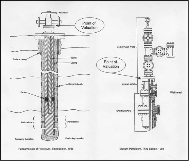
The diagram on the left is a simple well. It shows that the wellbore consists mostly of a cement sheath; and inside that, the well casing; and inside that, the well tubing. As the casing and tubing approach the top of the wellbore or hole, the ends must have reinforcement due to pressure and the need for stabilization at the top of the well. The reinforced end of the casing is called the “casinghead.” The end of the tubing is called the “tubinghead.” Attached at the ends of the casinghead/tubinghead are a set of valves connected to horizontal flowlines, as shown in the diagram. The casinghead, tubinghead, and attached valves constitute a “wellhead.” The flowlines deliver the oil or gas to other equipment. The configuration is typical for a low-pressure or free-flowing well.
The diagram on the right shows a typical configuration for a high pressure well. The series of valves and gauges attached to the casinghead/tubinghead is known as a “Christmas tree.” Its purpose is to confine and control the flow of fluids or gases from the well. The casinghead/tubinghead and the attached Christmas tree constitute a high-pressure “wellhead.”
The term “unprocessed,” as used in the Colorado Constitution, requires that the product or material receive no processing before valuation. Product flowing through the physical wellhead at the end of the casinghead/tubinghead qualifies as material that has received no processing.
The statute’s phrase “selling price at the wellhead” qualifies the “wellhead” as the point where the “unprocessed material” is valued. Allowable costs or expenses for “processing,” as stated in the statute, include both on-site and off-site processing because such processing occurs beyond the physical wellhead.
Point of Valuation at the Wellhead
For ad valorem purposes, the term “wellhead” is defined as “the point at the surface of the wellbore where there are connections to the casinghead/tubinghead, such as control valves, pressure gauges, testing equipment, and/or flowlines.” In the previous illustration, an arrow indicates the “Point of Valuation” for each wellhead. Direct costs and appropriate Return of Investment (RofI) and Return on Investment (ROI) related to control valves, pressure gauges, testing equipment, and/or flowlines are deductible netback expenses.
Historical Context of Wellhead Pricing and Statutes
Few oil and gas owners or operators actually sell their product at the physical wellhead (point of valuation). The term “selling price at the wellhead,” as traditionally used by the oil and gas industry, has frequently meant the price at the meter run, the price at the LACT unit, or the price at the outlet of the tank battery. The practice dates back to the period prior to the federal deregulation of the oil and gas industry when operators or owners could only sell product to pipeline companies. Current federal regulations permit operators or owners to sell to whomever and wherever they choose. Sales can occur at any designated point “downstream” from the physical wellhead. Regardless of the oil and gas industry’s practice, an ad valorem definition for “wellhead” must meet the criteria established by the Colorado Constitution and the statutes.
When completing the DS 658, it is the responsibility of the owner or operator to declare where the actual “point of sale” of an oil or gas product occurred. When the owner or operator’s gross lease revenues were determined to have occurred anywhere beyond the “point of valuation” at the wellhead, the revenues must be netted back to a wellhead selling price for assessment purposes.
Primary Production Valuation
For leaseholds and lands in primary production, the assessed valuation is eighty-seven and one-half percent (87.5%) of the following:
- The actual or determined selling price at the physical wellhead of product sold during the previous calendar year
- The actual or determined selling price at the physical wellhead for oil and gas sold in the same field area for product transported unsold from the premises during the preceding year
Example: Valuation of Leasehold in Primary Production
The subject is an oil well on state land that was producing in the prior year utilizing primary production methods. All products were sold to the first purchaser at the meter run. Costs (including RofI and ROI) related to the equipment used for on-site processing were deducted to arrive at a selling price at the wellhead.
The state land fractional royalty interest is 12.5% of gross production and totals $32,500. Royalty interest percentages can vary depending upon the terms of the lease; dollar amounts should be used. If the dollar amount is deducted it does not affect final value whether the deduction is from the gross or netback amount. The operator of the well filed a properly completed DS 658 for the assessment year.
Step #1 From Section C1 of the completed DS 658, determine the quantity of product (oil and gas) sold during the preceding calendar year.
Step #2 Also from Section C1 determine the point of sale price received for the product during the preceding calendar year.
Step #3 If the point of sale price is on a per-unit basis, multiply the quantity of product from Step #1 times the price from Step #2 to calculate the total value of the product sold.
Step #4 From Section D of the DS 658, determine the amount, in dollars, of royalty interest to be excluded and subtract that amount from the total value of the product sold to get the adjusted gross value.
Step #5 Determine the expenses (either by direct costs or by cost per barrel) that are appropriate to adjust the point of sale price back to the well head. These are known as the netback expenses.
Step #6 Deduct the netback expenses from the adjusted gross value to get the value of the product at the wellhead. This is the netback value.
Step #7 Multiply the netback value by 87.5% (the assessment percentage for primary production) to calculate the assessed value.
Calculation:
| Previous year’s amount of product sold | 4,000 Bbls |
|---|---|
| Previous year’s average point of sale price/Bbl | x $65.00 |
| Total Value of Product Sold | $260,000 |
| Less State of Colorado royalty | (32,500) |
| Adjusted Gross Value | $227,500 |
| Less Netback Expenses (if any) ($5.00/Bbl x 4,000 Bbls) | (20,000) |
| Netback Value | $207,500 |
| Statutory Assessment Rate | x 0.875 |
| Assessed value for oil and gas leasehold | $181,563 |
Only royalties paid to the United States government, the State of Colorado, counties, cities, towns, municipal corporations, or other governmental organizations within the State of Colorado, including Indian tribes are deducted. Royalties paid to any other person or entity are not deducted.
Secondary Production Valuation
For leaseholds and lands in secondary production, the assessed valuation is seventy-five percent (75%) of the following:
- The selling price at the physical wellhead of product sold during the previous calendar year
- The selling price at the physical wellhead for oil and gas sold in the same field area for product transported unsold from the premises during the preceding year
The calculation of the assessed valuation for a leasehold that has secondary or tertiary production for the whole year is the same as for primary production, except that the assessment rate is 75% instead of 87.5%.
An owner or operator, agent, or a person placed in control of the wellsite or lease by the owner or operator, claiming secondary production on the DS 658 must be on record with the Colorado Energy and Carbon Management Commission as approved for secondary production.
Example: Changing from Primary to Secondary or Tertiary Recovery
The producer/operator provided the amounts produced from each recovery method for the previous year. The subject is an oil well that was producing in the year prior to assessment utilizing both primary and secondary (water injection) production methods. All products were sold to the first purchaser at the outlet of the tank battery. Royalty interests have been deducted. Costs (including RofI and ROI) related to the equipment used for on-site processing were deducted to arrive at a selling price at the wellhead. The owner or operator of the well filed a properly completed DS 658.
Step #1: From Sections C1 and C2, determine the amount of product (oil and gas) sold for each recovery method during the preceding calendar year and the average price paid for the product during the preceding calendar year.
Step #2: For each recovery method, multiply the average netback wellhead price paid for the product by the amount of product sold during the previous calendar year to calculate the total value of the product.
Step #3: For each recovery method, multiply the total value of the product by the appropriate assessment rate: 87.5% for primary, 75% for secondary, to calculate the final assessed value.
Calculation:
Previous calendar year primary production 1,500 Bbls
Previous calendar year secondary production 2,500 Bbls
Average netback wellhead price paid per barrel $60.00/Bbl
Valuation of Primary Production
| Previous calendar year Primary Production | 1,500 Bbls |
|---|---|
| Previous year's average netback wellhead price per barrel | x $60.00 |
| Total value of product sold (Primary) | $90,000 |
| Assessment rate | x .875 |
| Assessed value | $78,750 |
Valuation of Secondary Production
| Previous calendar year Secondary Production | 2,500 Bbls |
|---|---|
| Previous year's average netback wellhead price per barrel | x $60.00 |
| Total value of product sold (Secondary) | $150,000 |
| Assessment rate | x .75 |
| Assessed value | $112,500 |
Total Assessed Valuation
| Primary Production Value | $78,750 |
|---|---|
| Secondary Production Value | + 112,500 |
| Total Production Value | $191,250 |
Example: Changing from Primary to Secondary or Tertiary Recovery Using the Percentage Allocation Method
The owner or operator of the well does not report the production under each method separately, although the assessor is aware of the change from primary to secondary/tertiary recovery. The assessor uses a percentage allocation method of valuation. The Colorado Energy and Carbon Management Commission (ECMC) has the date of change to another means of production for the wells, as well as the starting date of each secondary/tertiary recovery project.
The steps for the percentage allocation method follow:
- Calculate the percentage allocation for each recovery method by dividing the total number of days attributable to each recovery method by 365 days.
- Calculate the total value of production by multiplying the total production by the average netback wellhead price paid for the previous calendar year.
- Multiply the total value of production by the percentage allocation amount for each recovery method.
- Multiply the allocated total value of product sold by the appropriate rate – 87.5% for primary, 75% for secondary.
- Add the value at 87.5% to the value at 75% to arrive at total value for the production.
Assessed valuation attributable to secondary/tertiary recovery is abstracted separately from assessed valuation attributable to primary production.
Methods for Leasehold Valuation
To recognize that each oil and gas owner or operator may have different points of sale, a suggested listing of wellhead pricing procedures was created. Assessors are encouraged to use the following method that is most likely to result in the leasehold’s actual value. The suggested listing is intended to generate equitable leasehold values among all companies and counties.
- Actual Wellhead Price
- Netback of Related and/or Unrelated Party Costs to Value the Leasehold
- Use of Actual Charges to Unrelated Party/Parties as a Comparable Expense Deduction in a Related Party Relationship to Value the Leasehold
- Comparable Netback Sales Price to Value the Leasehold (Only this method should be used for Best Information Available [BIA] valuations.)
The operator is responsible for indicating on the declaration schedule which of the above methods listed is being used. The operator is also responsible for attaching any information (including the Netback Expense Report Form [NERF], if sent by the assessor along with the declaration schedule) to the DS 658 that supports the method used.
Note: If the Netback Expense Report Form is not mailed with the DS 658, a copy may be obtained from the Division’s website. See Addendum 6-J, Oil & Gas Netback IG Corporate Bond Rate, NERF, and NERF Spreadsheet Instructions for more information regarding the NERF.
Under no circumstances will the total deduction for netback of expenses, between the wellhead and the point of sale, exceed ninety-five percent (95%) of the total gross proceeds of product sold less exempt royalties paid. “Carry-forward” or “carry-back” of the unused operating expense, return on investment (ROI), and/or return of investment (RofI) deductions for prior or subsequent years is not allowed.
Netback Expense Report Form and NERF Spreadsheet
To aid the assessor in verifying allowable netback expense deductions, a Netback Expense Report Form (NERF) was developed in cooperation with the Oil and Gas Industry. This form, along with IG Corporate bond rating information, is included as Addendum 6-J, Oil & Gas Netback IG Corporate Bond Rate, NERF, and NERF Spreadsheet Instructions. The frequent use of the Netback Expense Report Form (NERF) resulted in a new electronic reporting tool, the “NERF Spreadsheet.” The NERF Spreadsheet is available to both assessors and taxpayers via the Division’s website. Please see Addendum 6-J, Oil & Gas Netback IG Corporate Bond Rate, NERF, and NERF Spreadsheet Instructions for instructions to access the NERF Spreadsheet on line. Once online, additional information necessary for completion of the spreadsheet is included in the tab labeled “Instructions.” The NERF Spreadsheet will aid the assessor in verifying allowable netback expense deductions and will assist the taxpayer in reporting those deductions.
The use of the NERF by assessors is at the assessor's discretion. The use of the NERF Spreadsheet by taxpayers is at the taxpayer’s discretion. If the assessor chooses to request completion and submission of a NERF, the form may be mailed with the DS 658 or later in the year after the declaration schedules are received. It should be mailed to all oil and gas owners or operators using either the related and/or unrelated party netback expense deduction method or comparable expense deduction method, to determine the wellhead price reported on the declaration schedule. If completion of the NERF is requested, the required filing deadline is 30 days after the date of the request, but no earlier than the statutory April 15th filing deadline for the declaration schedule, § 39-7-101(3)(a), C.R.S. If the NERF is sent along with the declaration schedule, it should be mailed to the oil and gas owner or operator as soon as practicable after January 1 of each year. However, the NERF may be mailed at any time during the current assessment year. In lieu of the NERF, taxpayers may respond by completion and submission of the NERF Spreadsheet electronically.
If an owner or operator, agent, or person placed in control of the wellsite or lease by the owner or operator, willfully fails or refuses to properly complete and submit the NERF, the NERF Spreadsheet, or any other requested supporting documentation within 30 days of the postmark date of the assessor's written request, but not before April 15, the assessor may assess a fine of one hundred dollars ($100) per day, § 39-7-101(3)(a), C.R.S.
The total amount of all fines assessed against an owner or operator, agent, or person placed in control of the wellsite or lease by the owner or operator in any calendar year shall not exceed three thousand dollars ($3,000), regardless of the number of leases or units owned or operated by the owner or operator or the number and length of the willful failures or refusals by the owner or operator.
The assessor may also place a BIA value on the leasehold, § 39-7-104, C.R.S. The Division recommends that the value be based on comparable netback wellhead prices, the average current field price, the average current county price, a statistical average of prices obtained from spreadsheets submitted to the county, or other comparative data.
If the owner or operator, agent, or person placed in control of the wellsite or lease by the owner or operator, properly completes and submits the NERF or NERF Spreadsheet after April 15, for the current assessment year, the assessor may rely on it as part of the "audit and review" procedure.
Oil and Gas Leasehold Valuation Methods
The ideal method for valuation of an oil or gas leasehold is to utilize a sales price that actually occurs at the physical wellhead, if that sales price is the bona fide, arm’s-length, weighted average sales price by product volume for the specific well during the twelve months preceding January 1. If such a price exists, no other leasehold valuation method is necessary. Since few, if any, sales prices are actually established at the physical wellhead, the following valuation methods are applied depending on how the operation is organized.
Netback of Unrelated Party Costs
The netback of unrelated party charges method to value the leasehold is used when:
- A bona fide arm’s-length sale price is received by the owner or operator at a point downstream from the wellhead, and
- Unrelated parties are paid for product on-site processing and gathering, and off -site processing, manufacturing, and/or transportation services between the physical wellhead and the actual point of sale.
When using this method, the amounts charged per unit for the transportation, manufacturing, and processing (both on-site and off-site) of the product volume from the physical wellhead to the point of sale by parties unrelated to the owner or operator are deducted from the downstream sales price to determine the wellhead selling price. No costs associated with activities that occur before the wellhead are to be deducted, e.g., down-hole costs, lifting costs, or pumping-related maintenance or operations costs.
Example:
ABC Oil, Inc., owns and operates the well, does its own on-site processing and gathering, pays GHI Processing, Inc. for off-site processing, and pays XYZ Pipeline, Inc., for transporting the product to its point of sale in Chicago.
Since the GHI Processing and XYZ Pipeline companies are not related to ABC Oil, ABC Oil may deduct the full cost of $0.75/Mcf (thousand cubic feet) for transporting the gas to market and the full cost of $0.35/Mcf for off-site processing. ABC Oil may also deduct its own direct costs for on-site processing and gathering, plus Return of Investment (RofI) and Return On Investment (ROI) on its own improvements and equipment that are used for the on-site processing and gathering. The deduction of all the declared costs from its gross lease revenues of $2.00/Mcf results in a netback selling price at the wellhead of $0.80/Mcf. ABC Oil is responsible for submitting supporting documentation for its own deductions, plus proof of receipts from GHI Processing and XYZ Pipeline companies for the netback deductions.
Netback calculations are as follows:
Retail Price/Gross Lease Revenues to ABC Oil: = $2.00/Mcf
Less: Transportation – XYZ Pipeline = - 0.75/Mcf
Adjusted Selling Price: = $1.25/Mcf
Less: Off-site Processing – GHI Processing = - 0.35/Mcf
Adjusted Selling Price: = $0.90/Mcf
Less: Direct Costs – On-site Proc. & Gathering = - 0.05/Mcf
Return On Investment (ROI) – ABC Oil = - 0.02/Mcf
Return of Investment (RofI) – ABC Oil = - 0.03/Mcf
Netback Selling Price at the Wellhead – ABC Oil: = $0.80/Mcf
If a direct exchange of product for downstream product processing services is agreed to as payment for the service, the fair market value of the exchanged product is documented by both the owner or operator and the provider of the service, then reported to the assessor before being allowed as a deductible cost. The owner or operator must include the market value of the exchanged product as part of the leasehold value reported to the assessor.
Netback of Related and Unrelated Party Costs
It is possible that both unrelated party and related party costs of service are used in the netback procedure. The combination may exist when part of the downstream cost of the product is paid to a party unrelated to the owner or operator, e.g., transportation costs from the processing plant to the point of sale at the transmission pipeline. Yet, from the physical wellhead to the point of transportation, the owner or operator, the gatherer, and the processor are all related parties or the same party.
Costs paid to an unrelated party for one or more services, e.g., wellsite processing, gathering, off-site processing or manufacturing, and/or transportation, are generally allowable in determining the netback wellhead price. Costs paid to related parties are deductible in accordance with the procedure in the Netback of Related Party Costs to Value the Leasehold section of these procedures.
Example:
In the following illustration, both related and unrelated parties are involved from the physical wellhead to the point of sale in Chicago. ABC Oil, Inc., owns ABC Processing, Inc., a related party. ABC Oil does not own the XYZ Pipeline company, which is an unrelated party. ABC Oil may deduct the full cost of XYZ Pipeline’s charge for transporting the gas from the processing plant to the point of sale in Chicago.
ABC Oil may deduct only ABC Processing’s direct costs, plus the ROI and RofI on ABC Processing’s off-site improvements and equipment. ABC Oil, Inc., may also deduct its own direct costs, plus ROI and RofI on its own on-site improvements and equipment to arrive at a netback selling price of $0.80/Mcf at the wellhead. ABC Oil is responsible for submitting proof of receipts from XYZ Pipeline and supporting documentation from ABC Oil and ABC Processing companies for the allowable deductions.
Netback calculations are:
Retail Price/Gross Lease Revenues to ABC Oil: = $2.00/Mcf
Less: Transportation – XYZ Pipeline = - 0.75/Mcf
Adjusted Selling Price: = $1.25/Mcf
Less: Direct Costs – Off-site ABC Processing = - 0.20/Mcf
ROI – ABC Processing = - 0.07/Mcf
RofI – ABC Processing = - 0.08/Mcf
Adjusted Selling Price: = $0.90/Mcf
Less: Direct Costs – On-site Proc. & Gathering = - 0.05/Mcf
ROI – ABC Oil = - 0.02/Mcf
RofI – ABC Oil = - 0.03/Mcf
Netback Selling Price at the Wellhead – ABC Oil: = $0.80/Mcf
Netback of Related Party Costs
The netback of related party costs method to value the leasehold is used when:
- There is no agreement between the owner or operator and any unrelated party responsible for wellsite processing, gathering, off-site processing, and/or transportation of the product to the point of sale, and
- There is a bona fide arm’s-length selling price received by the owner or operator at a point downstream from the physical wellhead, either by an actual sale of the product at the downstream point or by reference to other criteria, e.g., prices paid for a similar product at that point where a product is "taken-in-kind" and sold elsewhere by the owner or operator, and
- The same party owns, or related parties are paid for, on-site processing, product gathering, off-site processing, and/or transportation services between the actual wellhead and the first point of sale.
Example:
ABC Oil, Inc. owns ABC Processing, Inc. and ABC Pipeline, Inc. They are all related parties.
ABC Oil may deduct the allowable direct costs incurred by all three companies, plus ROI and RofI on the improvements and equipment owned by all three companies. The allowable direct costs plus ROI and RofI are deducted from the gross lease revenues of $2.00/Mcf to determine a netback selling price of $0.80/Mcf at the wellhead. ABC Oil is responsible for submitting supporting documentation from all three companies for the deductions used to arrive at a selling price at the wellhead.
Netback calculations are:
Retail Price/Gross Lease Revenues to ABC Oil: = $2.00/Mcf
Less: Direct Costs for Transportation = - 0.45/Mcf
ROI – ABC Pipeline = - 0.15/Mcf
RofI – ABC Pipeline = - 0.15/Mcf
Adjusted Selling Price: = $1.25/Mcf
Less: Direct Costs – Off-site Processing = - 0.20/Mcf
ROI – ABC Processing = - 0.07/Mcf
RofI – ABC Processing = - 0.08/Mcf
Adjusted Selling Price: = $0.90/Mcf
Less: Direct Costs – On-site Proc. & Gathering = - 0.05/Mcf
ROI – ABC Oil = - 0.02/Mcf
RofI – ABC Oil = - 0.03/Mcf
Netback Selling Price at the Wellhead – ABC Oil: = $0.80/Mcf
Use of Unrelated Party Charges as Comparables
This method is used when:
- The same party owns, or is related to the owner of, the gathering system and/or the gas processing plant, and
- Comparable gas produced by an unrelated party is being sold to the owner of the gas plant or is processed at the plant at a specified arm’s-length unit charge.
Example:
Under the methodology, the gas owned by an unrelated party or parties is gathered and/or processed for a fee. The taxpayer may claim, as a “proxy deduction” in the netback value calculation, the weighted-average of the fees paid by the unrelated party or parties for gathering and/or processing.
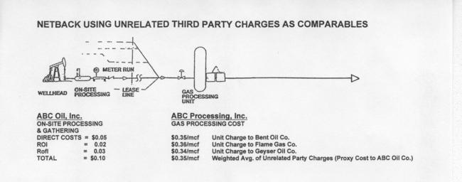
ABC Oil, Inc. owns ABC Processing, Inc. Though ABC Processing gathers and processes gas off-site for its related party, ABC Oil, it also gathers and processes gas for three unrelated companies: Bent Oil, Flame Gas, and Geyser Oil. The weighted-average for charges to the three companies is $0.35/Mcf. ABC Oil may use the weighted-average as a “proxy” expense for its cost of off-site gathering and processing through ABC Processing.
In the previous illustration, ABC Oil’s other deductions for related party costs for on-site processing and/or gathering are still allowable since the deductions are not reflected in the weighted-average “proxy” cost established from the unrelated parties. If ABC Oil had sold its gas for $1.25/Mcf to a pipeline company in an arm’s length transaction, the netback calculations would be as follows:
Selling Price to Pipeline Company: = $1.25/Mcf
Less: Average-Weighted “Proxy” Cost = - 0.35/Mcf
Adjusted Selling Price: = $0.90/Mcf
Less: Direct Costs – On-site Proc. & Gathering = - 0.05/Mcf
ROI – ABC Oil = - 0.02/Mcf
RofI – ABC Oil = - 0.03/Mcf
Netback Selling Price at the Wellhead – ABC Oil: = $0.80/Mcf
Since a weighted-average “proxy” cost was used, ABC Oil may not deduct RofI and ROI on the “proxy” cost, even though they are directly related to the ABC Processing company for which the “proxy” cost was developed. RofI and ROI were already included in the unrelated costs used to prepare the weighted-average “proxy” cost.
Instead of a weighted-average “proxy” cost, a taxpayer may also use the price of gas sold to its related gathering or processing company by unrelated parties as a “proxy value” for the gas owned by the taxpayer.
No costs associated with activities that occur before the physical wellhead are to be deducted: e.g., down-hole costs, lifting costs, or maintenance or operations costs related to the pumping unit.
When using weighted-average costs of service to unrelated parties as a deduction for related parties, the quality of the product and the terms and conditions under which the product is being processed and/or transported are considered. Both the unrelated and related parties' product must be comparable in order to properly determine the typical costs of service used.
All costs, for both unrelated and related party cost of services, are documented by the taxpayer and are subject to review and verification by the assessor in accordance with the review and audit procedures in this chapter. If the taxpayer fails to file the required netback expense report form (NERF), or the optional NERF Spreadsheet, if requested by the assessor, or any other documentation requested by the assessor, the assessor has the option to assign a Best Information Available (BIA) wellhead value.
Comparable Netback Sales Price (BIA Valuation)
The comparable netback sales price is defined as the bona-fide arm’s-length, weighted-average, sales price determined from the netted back selling prices, by product volume, of comparable oil and/or gas products sold at other oil and gas wellsites during the preceding year. Use of the comparable netback sales price method to value the leasehold takes into consideration the quality of the product and the terms and conditions under which the product is sold.
This method is used only for Best Information Available (BIA) valuations. The assessor may establish a BIA valuation when the following situations occur:
- The taxpayer fails to file a completed declaration schedule and/or a completed Netback Expense Report Form (NERF) if requested by the assessor, or
- The netback expense information provided on the form is inconsistent or incomplete with regard to the actual downstream sales price or expenses required to gather, process, manufacture, or transport the product from the wellhead to the point of sale.
If questions arise regarding downstream sales prices and netback deductions, assessors can utilize the review and audit procedures listed in Review and Audit of Oil and Gas Declaration Information, located later in these procedures, to resolve any problems. No costs associated with activities occurring before the physical wellhead are to be deducted, e.g., down-hole costs, lifting costs, or maintenance and/or operations costs related to the pumping unit.
All information provided to the assessor is confidential, § 39-7-101(4), C.R.S.
Netback Calculation Definitions
Per agreement with assessors and industry, the following definitions only pertain to the netback methods to value the leasehold interest. The definitions are to be adhered to by both the assessor and the declarer when determining leasehold value net of unrelated or related party costs. In every case, the declarer should indicate the leasehold valuation method used on each returned declaration schedule.
Plant or facility depreciation or recapture: the annual expense associated with the amortization of the capitalized cost of a plant or facility, calculated based on a share of gross revenue attributable to a particular product on a units-of-production or straight-line basis and used by the taxpayer for financial statement purposes, in accordance with generally accepted accounting principles.
Related parties: the individuals who are connected by blood or marriage; or partnerships; or businesses that are subsidiaries of the same parent company or are associated by one company controlling or holding ownership of the other company's stock or debt.
Return of Investment (RofI): the owner’s recovery (recapture) of capital invested in equipment and improvements at the wellsite. The return comes through the gross lease revenues from the well’s production that is sold or transported from the premises.
Return on Investment (ROI): the additional amount received by the owner as compensation for the use of the owner’s invested capital until it is recovered (recaptured). The rate of return on invested capital is analogous to the interest rate on a bond investment or certificate of deposit. The return also comes through the gross lease revenues from the well’s production that is sold or transported from the premises
Netback Deductions Involving Related Parties
Related parties may take specific deductions from gross lease revenues to determine the net selling price at the wellhead. Deductions may be taken for allowable direct operating costs or expenses, for Return On Investment (ROI), and for Return of Investment (RofI). Netback expenses may be claimed by the taxpayer or by parties directly related to the taxpayer. To ensure that a taxpayer’s netback deductions are supportable, the deductions must meet the following criteria.
Deduction of Direct Operating Costs
Direct operating costs are defined as costs incurred during the previous calendar year that are directly associated with on-site processing and gathering, and off-site processing, manufacturing, and transportation of the product from the physical wellhead to the point of sale. Direct operating costs are deductible from the downstream gross lease revenues to determine the netback selling price at the wellhead. No costs associated with activities that occur before the physical wellhead are to be deducted: e.g., down-hole costs, lifting costs, or maintenance or operations costs related to the pumping unit.
Allowable Operating Cost Deductions
Operating costs directly related to the operation and maintenance of the equipment and facility that are typically allowed are:
- Salaries, wages, and benefits paid by the entity claiming the deductions to employees and supervisors directly involved with the wellsite activity or related off-site activity.
- Fuel (including electricity or natural gas) and utility costs.
- Materials and supplies including chemicals and lubricants.
- Non-capitalized repairs, including labor and materials related to gathering, on-site and off-site processing, or transportation of the product from the wellhead. Deductions for repairs and/or maintenance of the pumping unit or down-hole equipment are not allowed.
- Field labor costs, including third party charges that are related to on-site and off-site processing, and transportation of the product from the wellhead to the point of sale.
- Costs related to the repairs and maintenance of the above-ground wellsite equipment.
- Costs incurred for the sale of the product at the point of sale.
- Taxes on real property improvements and personal property attributable to the facility.
- Cost of preparing an environmental impact statement.
- Annualized insurance expense, including workman’s compensation insurance, general or public liability insurance, and automobile public liability insurance for vehicles used at the site.
- Payroll taxes.
- Unrelated party rental, leasing, or contract service costs for operation of the equipment and facility.
- Allocated direct general and administrative overhead costs, e.g., headquarters personnel, telephone service, payroll taxes, employee benefits, vehicle expenses, office supplies, etc., that represent typical expenditures allocable to the operation and maintenance of the equipment and facilities, both on-site and off-site.
In some instances, actual costs for some or all of the above items may not be available by well. When costs are not available by well, both the assessor and taxpayer can establish and agree to a reasonable basis for an allocation of costs between deductible and non-deductible categories or processes. Once the allocation methodology is established, it cannot be changed without agreement of the county assessor. Replacement costs or “proxy” costs cannot be used in lieu of historical costs. The owner or operator must provide actual historical costs.
The above list is not all-inclusive. Additional costs necessary for the gathering, on-site and offsite processing, and transportation or movement of the product from the actual wellhead to the point of sale may be allowed. A good “rule of thumb” is that the costs associated with a process that adds value to the oil and gas product prior to sale are allowable.
Non-Allowable Operating Cost Deductions
Direct operating costs that are not allowable are:
- Down-hole production and operating costs incurred to extract or move the product from the reservoir to the wellhead. Included in the category are costs for gas, water, and/or CO2 injection done as part of a secondary recovery process.
- Royalty payments (royalty payments to property tax exempt entities are excluded later to determine the taxable leasehold value).
- Costs related to the repairs and/or maintenance of the pumping unit, tubing, casing, liners, or down-hole equipment, parts or supplies.
- Drilling or well-completion costs, including expenses for cementing and/or perforating of the wellbore.
- Legal costs, title opinions, and any other pre-drilling or pre-production costs.
- Work-over, “well-pulling”, or well re-completion costs.
- Federal and state severance, income, or other taxes (except payroll taxes and improvement and equipment property taxes).
- Theoretical or actual line losses or “shrinkage.”
- Property taxes on oil and gas leaseholds and lands.
- Oil and gas depletion allowances.
- Any other cost that is not considered a direct operating cost of gathering, on-site or offsite processing, manufacturing, and transportation, including construction period interest.
- Capitalized interest charges expended during development and/or construction, either as a separate line item or included as a component in the undepreciated investment balance.
Deductions - Return On Investment (ROI) and Return of Investment (RofI)
Related party and vertically integrated (combined production, on-site and off-site processing, and/or transportation company) operators are entitled to deduct an amount for ROI and an amount for RofI on their capital assets. Capital assets are depreciable fixed assets necessary for on-site processing and gathering, and off-site processing, manufacturing and transportation of the oil and gas product to the point of sale. Fixed asset costs for real property include costs of construction of an improvement or structure, but do not include costs of acquiring land upon which the structure is built. Fixed asset costs for personal property include the cost of acquisition, cost of delivery, sales tax, and installation of the personal property item.
Since ROI represents the additional amount received by the owner as compensation for the use of the owner’s invested capital until it is recovered (recaptured), the return comes through the gross lease revenues from the well’s production that is sold or transported from the premises. ROI is analogous to the interest rate on a bond investment or certificate of deposit.
RofI, on the other hand, represents the owner’s recovery (recapture) of capital invested in equipment and improvements at the wellsite. The return also comes through the gross lease revenues from the well’s production that is sold or transported from the premises.
Determining ROI and RofI require different bases for their calculations:
- ROI requires an average of the remaining undepreciated investment balance of includable assets on January 1 of the prior calendar year and the remaining depreciated investment balance of includable assets as of December 31 of the prior year.
- RofI requires only the remaining, undepreciated investment balance of includable assets on January 1 of the prior year as the base.
RofI and ROI are not allowed on acquisition and installation of pumping units, casing and tubing, down-hole equipment, and any other machinery and equipment used to extract, produce or lift the product from the reserve to the wellhead.
Included Assets In the Physical Asset List
Assets that can be included:
- Buildings, shops, laboratories, sidewalks and fences, roads and other structures and improvements that are directly related to the wellsite processing, gathering, off-site processing, and/or transportation of the product from the actual wellhead to the point of sale, and that are located either on the lease or within the production field area.
- Machinery and equipment directly used for wellsite processing, gathering, off-site processing or manufacturing, and transportation.
- Environmental equipment that is an integral part of the facility.
- Piping and flow lines including meters, valves, and fittings.
- Water wells and supply systems, heat, sewage, and other utility systems located at the facility site.
The above list is not all-inclusive. Any capital assets directly involved in the on-site processing and gathering, or off-site processing or manufacturing, and transportation are included.
Excluded Assets from the Physical Asset List
Assets that must be excluded:
- Pumping unit, casing, tubing, liners, and down-hole equipment.
- Non-depreciable property such as land and pipeline rights-of-way.
- Capitalized improvements or assets that are not an integral part of the wellsite processing and gathering, or off-site processing or manufacturing, and/or transporting operation.
- Capitalized interest charges expended during development and/or construction, either as a separate line item or included as a component in the undepreciated investment balance.
Determining the Amount of ROI Deduction
The actual amount allowed for deduction will be the lesser of:
- The actual ROI obtained by the related party in providing the wellsite processing and gathering, and off-site processing or manufacturing, and/or transportation service, if the related party lists on its books and records a charge for any of these services from which an actual ROI can be determined, or
- A calculated ROI amount based on the average undepreciated investment balance for the calendar year prior to the year of assessment of the improvements and personal property multiplied by the average industrial bond yield rate for the calendar year prior to the year of assessment as published by the Division.
The industrial bond rate is to be used whenever it is less than the actual rate of ROI. For oil and gas companies that cannot, for accounting purposes, calculate an actual ROI, the published ROI is allowed for determining the deduction for return on investment. Please refer to Addendum 6-J, Oil & Gas Netback IG Corporate Bond Rate, NERF, and NERF Spreadsheet Instructions, for the current published Netback IG Corporate Bond Rate.
Example:
The Derrick Oil & Gas Company declared the following information using the Netback Expense Report Form (NERF):
| Total Original Plant Investment: | $30,000,000 |
|---|---|
| Less: Accum. Depreciation to Jan. 1 of prior year: | - 10,000,000 |
| Beginning Plant Investment, Prior Year: | $20,000,000 |
| (Jan. 1, prior calendar year) Less: Accum. Depreciation, Prior Year | - 1,000,000 |
| Ending Plant Investment, Prior Year: (Dec. 31, prior calendar year) | $19,000,000 |
| Average Plant Investment: | $19,500,000 |
| Division Published ROI Rate (5.38%)*: | x .0538 |
| ROI Deduction Amount: | $1,049,100 |
*From Addendum 6-J.
Determining the Amount of RofI Deduction
The actual amount allowed for deduction may be calculated either by:
- Dividing the remaining undepreciated investment balance of the improvements and equipment by the asset life of the improvement or equipment item using a non-accelerated, straight-line depreciation schedule, or
- Using a Units-of-Production (UOP) method.
Example: Investment balance divided by asset life method (a.)
The Derrick Oil & Gas Company declared the following information, using the DS 658 and the Netback Expense Report Form (NERF):
| Plant Investment - Equipment (as of January 1 prior calendar year) | $16,000,000 |
|---|---|
| Remaining Asset Life of Equip. (14 yrs) | ÷ 14 |
| Annual Recapture | 1,142,857 |
| Plant Investment – Improvements (as of January 1 prior calendar year) | $ 4,000,000 |
| Remaining Asset Life of Imps (25 yrs) | ÷ 25 |
| Annual Recapture | $ 160,000 |
| Total RofI Deduction | $ 1,302,857 |
Example: Using the Units-of-Production (UOP) method (b)
The Derrick Oil & Gas Company declared the following information, using the DS 658 and the Netback Expense Report Form (NERF), and reserve estimates from its IRS return:
| Prior Year's Production (Mcf) | 1,000,000 |
|---|---|
| Estimated Remaining Amount in Reserves (Mcf) | ÷ 15,000,000 |
| Annual UOP Recapture Allocation % | 6.67% |
| Plant Investment – Equipment & Improvements (as of January 1 prior calendar year) | $20,000,000 |
| UOP Recapture Allocation Percentage | x .0667 |
| Total RofI Deduction | $ 1,334,000 |
If the UOP method is selected, the taxpayer provides the assessor with adequate documentation, including reserve estimate information furnished to the IRS that indicates the probable recoverable reserve amount existing under the leasehold.
Once a depreciation method has been selected, it cannot be changed except by approval of the county assessor.
All costs, for both unrelated and related party services, must be documented by the taxpayer and are subject to review and verification by the assessor in accordance with the review and audit procedures in this chapter. If the taxpayer fails to file the NERF or any other documentation as required by the assessor, the assessor has the option to assign a BIA wellhead value.
Assessment of Natural Gas Liquids
Natural gas liquids (NGLs) produced from oil and gas leaseholds and lands are organic hydrocarbon products suspended within a natural gas stream. The unprocessed natural gas stream containing the NGLs is termed “wet gas.” The NGLs are termed “entrained liquids,” and include ethane, propane, and butane among other organic compounds that are produced from the oil and gas wellbore. After the NGLs are extracted from the natural gas stream, the remaining product consists primarily of methane and other combustible gases termed “residue,” “residue gas,” or “dry gas.”
After NGLs are removed, the residue gas is compressed and transported, generally through pipelines, to end users. NGLs are shipped, usually by truck or pipeline, from the gas processing plant to a facility where they are separated into their constituent parts by a process known as fractionation.
Accounting for the value of NGLs in the oil and gas leaseholds and land valuation process is done differently depending on the point of sale of the natural gas stream.
- If the point of sale and transfer of the “wet” natural gas product is done at the wellhead, or at any point prior to separation and/or NGL extraction, the value of any entrained NGLs is presumed to be included in the price-per-Mcf paid for the “wet” gas. It is not possible to value the NGLs separately.
- If the point of sale and transfer of the NGLs is after separation and/or extraction, both the residue gas and NGLs are separately valued. However, the values of both the residue and the NGLs must be “netted back” to what the product would have sold for at the wellhead.
The netback adjustments must account for all on-site and off-site processing and transportation costs that were expended to make the product marketable and transport it to the point of sale. For additional information on the netback process refer to Description of Oil and Gas Leasehold Valuation Methods earlier in this chapter.
There are various ways of accounting for NGL processing. One way is for the gas processor to retain a portion of the NGL gross lease revenues as the fee for extraction of the NGLs from the gas stream. In years when the price of crude oil and NGLs is high, the proceeds retained by the natural gas process may also pay for processing the residue gas as well.
Example:
Horizon Oil Inc. operates a 40-acre lease that produces unprocessed gas with entrained natural gas liquids (NGLs) from a single well. Horizon meters the unprocessed gas at the wellsite and ships it through its own gathering system to a plant owned by Aurora Gas Processing.
At the plant, the gas is processed, NGLs are extracted, and the residue gas is compressed for shipment into the Sunset Gas Transmission Pipeline. The previous year’s production from the well was 60,000 Mcf of gas with 6,000 gallons of associated NGLs. The average price paid for the NGLs during the previous year was $1.00/gallon. Fifty-eight thousand (58,000) Mcf of residue gas was sold at the inlet to the gas transmission pipeline for $4.50 per Mcf. According to the contract between Horizon and Aurora, Aurora agrees to separate the unprocessed gas into pipeline quality residue gas and extract the associated marketable NGLs. For processing and compressing the gas for pipeline shipment, Aurora keeps 50% of the NGL gross lease revenues.
Costs documented by Horizon:
Gathering: $27,000 $.45 per Mcf
The above costs were claimed in total when the netback valuation of the residue gas was calculated. Based on the published oil and gas netback procedures, the netback wellhead valuation of the residue dry gas and the NGLs is shown below:
Dry Residue Gas
| Dry Gas – Gross Lease Revenues (58,000 Mcf x $4.50/Mcf): | $261,000 |
|---|---|
| Gathering expenses: | - 27,000 |
| Off-site (gas plant) processing expenses: | - -0-A |
| Netback Wellhead Value of dry residue gas: | $234,000 |
| Primary Production Assessment Rate (87.5%): | x .875 |
| Assessed Value of dry residue gas: | $204,750 |
NGLs
| NGL – Gross Lease Revenues (6,000 gals x $1.00/gallon): | $ 6,000 |
|---|---|
| NGL extraction fee (6,000 gal x 50% x $1.00/gallon): | - 3,000 |
| NGL Value (prior to processing): | $ 3,000 |
| Gathering Expense: | - -0-B |
| Netback Wellhead Value of NGLs: | $ 3,000 |
| Primary Production Assessment Rate: | x .875 |
| Assessed Value of NGLs: | $ 2,625 |
A Since the processing cost includes the cost of processing the residue gas as well as the NGLs, no additional deduction for processing is allowed when determining the netback value of the residue gas.
B Since gathering costs were already claimed by the operator in valuing the residue gas at the wellhead, it would be improper to allow an additional deduction for the NGL netback valuation.
It is important that separate netback deduction calculations be completed for the residue gas and for the extracted NGLs to avoid deducting the netback processing or transportation costs twice. If a well producing natural gas has NGLs separately valued from the residue gas, information is required showing how deductible costs are allocated for both transportation and processing of the residue gas and transportation and processing of the NGLs.
Calculations for ROI and RofI have not been shown in the NGL example, but are deductible when determining the netback selling price at the wellhead. Please see the calculation examples under Deductions for Calculating Return On Investment (ROI) and Return of Investment (RofI).
Landfill Methane Extraction Production
Gas extraction operations located on sanitary landfills, or lands from which gas from decomposing material is extracted for sale, are assessed at 75% of the value of the gas sold or transported from these operations. Taxpayers are required to file a DS 658 with the county assessor.
Valuation procedures for landfill methane extraction operations are the same as for other secondary, tertiary, or recycling/recovery operations.
Shut-In and Capped Wells
Shut-in and capped wells are wells that are still capable of production, but due to economics or other circumstances, were temporarily taken out of production for the entire previous calendar year. Oil and/or gas resources may remain in the ground.
Wells that were shut-in and capped as of the assessment date, but from which oil and/or gas was sold or transported during the previous calendar year, should be valued based upon that production volume. Wells that were shut-in and capped for a period of time in excess of the previous calendar year are not valued, except for the valuation of personal property on the site. Personal property includes a wellhead and equipment stored on the site.
If the oil and gas mineral interest is severed from the surface ownership and there was no production from the shut-in and capped well(s) during the previous calendar year, the interests are valued as nonproducing oil and gas mineral interests, § 39-7-109, C.R.S. Please refer to the Valuation Procedures for Nonproducing Severed Mineral Interests in this chapter.
If the oil and gas mineral interest is not severed from the surface ownership and there was no production from the shut-in and capped well(s) during the previous calendar year, no value is assigned. Mineral rights are not separately valued from surface real estate in Colorado unless the ownership of those mineral rights is severed from the surface ownership.
Plugged and Abandoned Wells
Plugged and abandoned wells are wells with no foreseeable future production. Any remaining reserves have no current, profitable method of recovery.
Wells that were plugged and abandoned as of the assessment date, but from which oil and/or gas was sold or transported during the previous calendar year, are valued on the actual production volume for the previous calendar year. For plugged and abandoned wells without any production during the prior calendar year, only the value of the equipment stored at the wellsite should be listed and valued if it was not held for sale. Any severed mineral interest in the lands will become taxable once production has ceased permanently. Please see Valuation Procedures for Nonproducing Severed Mineral Interests in this chapter.
Gas Flared, Vented, or Re-Injected on the Lease
Gas that is flared, vented, or re-injected on the lease to maintain field pressure is not valued. The statutes only provide for assessing the product that is sold or transported from the premises, § 39-7-102, C.R.S.
Other Issues
Confidentiality Requirements
All information or documentation provided to the assessor, the Property Tax Administrator, the annual study contractor hired under § 39-1-104(16), C.R.S., the executive director of the department of revenue, and their employees, will be considered private and confidential, § 39- 7-101(4), C.R.S. Such information or documentation includes declaration schedules, accompanying exhibits, the Netback Expense Report Form (NERF), electronic or printed spreadsheet files, any documentation supporting the NERF, and any other information or documentation supplied as part of the audit or review process.
Best Information Available Assessments
If the declaration schedule fails to provide sufficient information to determine or justify the reported value, the assessor utilizes; comparable netback wellhead prices, the average current field price, the average current county price, statistical-average prices from spreadsheets, or other comparative data to value the product. Please see Review and Audit of Oil and Gas Declaration Information in this chapter.
It is strongly advised that the assessor statistically analyze the reported prices-per-unit from all declaration schedules. Please see Statistical Review of Wellhead Prices, later in this chapter, for additional information.
Taxpayer Notification
The well or unit operator is the sole point of contact for all notification, review, audit, protest, abatement, and appeal procedures, § 39-7-110(2), C.R.S. Whenever leasehold values determined by the assessor differ from the values reported on a declaration schedule, the assessor must notify the operator or owner/operator using the “Note” field on the Notice of Valuation (NOV).
Excludable Royalties
Royalties that are delivered as cash or as product to governmental entities are excluded from the gross revenues before calculating actual value at the wellhead. The exclusion is the actual royalty amount paid, not necessarily the royalty declared, whether shown as a fraction, percentage, or flat amount. The actual royalty paid is subtracted from the total value of the product sold or transported. Governmental entities include any interests owned by: the United States government, State of Colorado, counties, cities, towns, municipal corporations, or any other governmental entities within the State of Colorado, including Indian tribes.
Oil/Gas Leaseholds, Lands Sold Previous Calendar Year
When producing oil and gas leaseholds and lands are sold or conveyed to a new owner during the year, a declaration is filed by the new owner of the property for the assessment year following the year in which the oil and gas property was sold or conveyed. All oil and gas production and sales information, including the amount of oil and gas produced, sold, flared/vented, and used on lease for the entire preceding calendar year, is reported to the assessor, § 39-7-101(1), C.R.S.
The requirement applies to oil and gas sold, or transported unsold, from the premises during the preceding calendar year by both the previous owner and the current owner. If the new owner is unable to get an accounting of oil and gas production from the prior owner, an alternative source of information is the Colorado Energy and Carbon Management Commission (ECMC) Form 7 submittals made by the prior owner for the months in question. The ECMC may be contacted at (303) 894-2100, or through its website: https://ecmc.state.co.us/#/home.
New owners of oil and gas leaseholds and lands are responsible for the entire property tax lien that attaches on the January 1 assessment date following the transfer of the property. Any liability for property taxes arising from oil and gas sales occurring prior to the date of conveyance of the leasehold should have been settled at the time of closing, §§ 39-1-107 and 39-7-108, C.R.S.
Level of Value for Producing Oil and Gas
All producing oil and gas leaseholds and lands are valued at current value using the previous year's production information, §§ 39-1-103(2) and 104(12)(b), and 39-7-101 and 102, C.R.S.
Review and Audit of Oil and Gas Declaration
The assessor may request information from a taxpayer relating to the actual value of any property located within the county, § 39-5-115(1), C.R.S. Assessors may conduct reviews or audits of taxpayer oil and gas declarations and may request supporting documentation associated with specific wells owned or operated by the taxpayer, § 39-7-101(3) and 105, C.R.S.
A review is defined as an analysis of oil and gas production and sales volumes, expressed in Bbl (barrels) or Mcf (thousand cubic feet), reported on the DS 658 Oil and Gas Real and Personal Property Declaration Schedule filed by the taxpayer, as compared to reports Form 7 and Form 8 filed with the Colorado Energy and Carbon Management Commission (ECMC). Also included under the review process is an analysis of requested supplemental information under § 39-7-101(3), C.R.S., which may include the Netback Expense Report Form (NERF).
- The ECMC Form 7 is filed monthly by the lease operator and contains detailed production volume information reported by the operator for all interest owners of the well. Form 7 also is the method by which the ECMC maintains its production database. Form 7 includes unsold production stored at the lease site, which is not assessable until it is sold or transported from the lease site unsold. Form 7 is public information.
- The ECMC Form 8 is filed quarterly, usually by the first purchaser or the operator. Form 8 contains both volume and price information for the operator, but sales price information is not available by lease or by well. ECMC Form 8 submissions are by operator instead of by lease. Only a composite sales price by operator is available for comparison. Therefore, Form 8 information cannot be relied upon for calculation of average field price. Form 8 is the method by which the ECMC collects its conservation levy. Form 8 is public information.
An audit is defined as an examination and analysis of taxpayer's records, including source documents, regarding production and sale volumes, sales price per Bbl. or Mcf., or any other information reported by the owner or operator.
Purpose and Scope
Section 39-2-109(1)(k), C.R.S., requires the Administrator to develop guidelines for the review and audit of oil and gas leaseholds and lands.
The guidelines provide procedures and instructions for the review or audit of information filed with the county assessor, pursuant to § 39-7-101, C.R.S.
All county assessors, county treasurers, and their agents must utilize the procedures and instructions, § 39-2-109(1)(k) C.R.S. For the purpose of the procedures, a county’s "agent" is defined as "any person or business that contracts with the county to perform reviews or audits of oil and gas production records to determine if the amounts declared by taxpayer(s) to the county are correct."
Oil and Gas General "Review" Procedures
Counties are permitted to establish reasonable "review" procedures that fairly and accurately determine if any discrepancy exists between the taxpayer's declared oil and gas production and sales volumes and the amounts indicated by other information sources. The following must be included in the county's review program for oil and gas taxpayers:
All of a taxpayer's wells within the same field or unitized operation shall be included in the review process. The following reports are sources that can be used for review purposes:
Colorado Energy and Carbon Management Commission (ECMC) online production reports derived from Forms 7 and 8. As of July 1, 2001, data taken from Form 8 reports submitted to the ECMC contain only composite sales information by operator. Information is not available by well. The actual Form 7 and Form 8 reports can only be viewed or reviewed by going in person to the ECMC record-keeping facility at:
Colorado Energy and Carbon Management Commission
The Chancery Building
1120 Lincoln Street, Suite 801
Denver, CO 80203
Phone: 303-894-2100Various kinds of valuable information can be obtained online through the ECMC website. Please see Addendum 6-H, Instructions for Accessing the ECMC Website, at the end of this chapter.
If supporting documentation is requested by the assessor, including a completed NERF requested under § 39-7-101(3), C.R.S., the taxpayer has the option of submitting either the NERF or an electronic NERF Spreadsheet in addition to any other requested materials.
The county assessor must provide a letter to the taxpayer, by certified mail, indicating that a "review" of the taxpayer's oil and gas declaration was conducted. The letter must include:
- A listing of the assessment years reviewed.
- A listing of the wells, leases, units, or fields reviewed.
- A listing of the sources used to determine any apparent volume discrepancies.
- An explanation of any discrepancies between the taxpayer's declaration and the sources utilized by the county. Include in the explanation a listing of the taxpayer's declared volumes and the amounts indicated on the county's source reports.
In computing the value of the indicated under-or-over-reporting of volume, the county utilizes the taxpayer's average price as declared on the taxpayer declaration for the specific year under review.
- Any requests for additional information regarding the taxpayer reporting discrepancy.
- A listing of the taxpayer's rights in the "review" process.
Please refer to the Oil and Gas Taxpayer "Review" Rights section of these guidelines for further information.
- If a change in valuation is determined, the county uses the Division-approved Special Notice of Valuation, Special Protest Form, and Special Notice of Determination forms listed in ARL Volume 2, Administrative and Assessment Procedures, Chapter 9, Form Standards. If the county wishes to develop its own form(s), the Division of Property Taxation must approve each form prior to use.
A Special Notice of Valuation is mailed after the taxpayer response period expires. The assessor may grant additional response time at the request of the taxpayer. If the taxpayer requests additional time, and if the assessor grants it, the assessor must wait until the complete response period, as granted, expires.
- If the taxpayer does not provide the requested information, or refuses to make the information available, the assessor may:
- File in District Court under § 39-5-119, C.R.S., for a court order compelling the taxpayer to immediately cooperate with the assessor; or
- Issue a Best Information Available (BIA) assessment.
Oil and Gas Taxpayer "Review" Rights
The following rights are provided to all taxpayers subject to a county oil and gas "review:"
- At the request of the taxpayer, the county schedules a meeting to discuss the discrepancies and to receive any further information from the taxpayer.
- At the request of the taxpayer, the assessor provides the taxpayer copies of all information used to determine the discrepancy.
- Taxpayers have at least 30 days to respond to the "review" notification letter and to provide additional information to the county regarding the listed discrepancies. The assessor may grant additional time at the request of the taxpayer.
- Taxpayers have 30 days to protest the value indicated on the Special Notice of Value. The county must consider all information supplied by the taxpayer in protest.
- If a taxpayer files a protest, the county issues a Special Notice of Determination. Language regarding a taxpayer’s appeal rights for filing an abatement petition is included in the Special Notice of Determination.
Statistical Review of Wellhead Prices
It is strongly advised that the assessor choose a convenient time within the assessment year to statistically analyze the reported prices-per-unit from all declaration schedules. Information is analyzed by well and stratified by field.
At a minimum, the data is arrayed from low to high. Measures of central tendency (median and mean) are established for independent operators, producers, and other royalty interest owners for all schedules. These statistical analyses aid the assessor in determining which declaration schedules to review further.
If the assessor finds, in any year, a reported price-per-unit of product outside of the range of the prices-per-unit being reported by other oil and gas taxpayers, the assessor can request additional supporting information and further documentation of the calculations used to establish the reported price-per-unit.
If the declarer fails to adequately respond to the assessor's requests for additional information, or if the final information supplied by the taxpayer does not support the reported value-per-unit, the assessor may establish a 100 percent leasehold interest value for the leasehold using the procedure for Best Information Available Assessments.
In the event that the assessor determines a value based on a quantity or wellhead selling price different than that reported by the taxpayer, the assessor may send the taxpayer a notice identifying omitted oil and gas value as omitted property. § 39-10-107, C.R.S. defines omitted oil and gas as, “underreporting of the selling price or the quantity of oil and gas sold therefrom.” This was affirmed by the Colorado Supreme Court in Kinder Morgan CO2 Co Lp v. Montezuma County Board of Commissioners, Board of Assessment Appeals, and Colorado Property Tax Administrator, 396 P.3d 657 (Colo. 2017).
Oil and Gas General Audit Procedures
Counties are permitted to establish reasonable "audit" procedures to fairly and accurately determine the actual value of oil and gas leaseholds and lands. The county's audit program must include the following:
- When a taxpayer is selected for audit, all of the taxpayer's wells within the same field or unitized operation are included, unless the scope of the audit is limited by agreement of both parties.
- The county assessor provides a letter to the taxpayer, by certified mail, indicating that an "audit" of that taxpayer's oil and gas declaration will commence no sooner than 15 days after receipt of the letter. The audit notification letter must include:
- A listing of the assessment years under audit.
- A listing of the wells under audit.
- A listing of all pertinent records, including but not limited to, accounting, production sales, and tax records being requested by the county designated auditor.
- Upon completion of the "audit," the county:
- Mails a notice of preliminary "audit" findings to the taxpayer at the address recorded on the annual declaration.
- Gives the taxpayer 30 days from the date of notice to submit additional information not considered by the county. The county may grant extensions of time upon request.
- Considers all additional information provided by the taxpayer to the assessor or to the county designated auditor.
- Provides a listing of the taxpayer's rights in the "audit" process. See below.
- If a change in valuation is determined, the county uses the Division-approved Special Notice of Valuation, Special Protest Form, and Special Notice of Determination forms listed in ARL Volume 2, Administrative and Assessment Procedures, Chapter 9, Form Standards. If the county wishes to develop its own form(s), the Division of Property Taxation must approve each form prior to use.
- If the taxpayer does not provide information or refuses to make information available, the assessor may:
- File in District Court under § 39-5-119, C.R.S., for a court order compelling the taxpayer to immediately cooperate with the assessor; or
- Issue a Best Information Available (BIA) assessment.
Oil and Gas Taxpayer Audit Rights
The county must provide the following rights to all taxpayers subject to an oil and gas "audit."
- Taxpayers have 30 days to protest the value indicated on the Special Notice of Valuation. The county must consider all information supplied by the taxpayer in protest.
- If a taxpayer files a protest, the county issues a Special Notice of Determination including a written explanation regarding the basis for the omitted property and the county’s decision. Language regarding a taxpayer’s appeal rights for filing an abatement petition is included in the Special Notice of Determination.
Other Review/Audit Procedures and Requirements
Oil and Gas Omitted Property Tax Collection Procedures
After the Special Notice of Valuation has been mailed and the 30-day taxpayer protest period has expired, the county may proceed to issue a tax bill to cover the omitted taxes.
Oil and Gas Confidentiality Requirements
All information or documentation provided to the assessor, the Property Tax Administrator, the annual study contractor hired under § 39-1-104(16), C.R.S., and/or their employees or agents, will be considered private and confidential under the provisions of § 39-7-101(4), C.R.S. Such information or documentation includes declaration schedules, accompanying exhibits, the Netback Expense Report Form (NERF), electronic or printed spreadsheet files, any documentation supporting the NERF, and any other information or documentation supplied as part of the audit or review process.
Contractual Arrangements
When agents are authorized by counties to perform audits or reviews, counties are to include language in audit contracts or legal agreements indicating that agents are bound by the provisions of § 39-5-120, C.R.S. Further, unauthorized release of any confidential information or documents is subject to the provisions of § 39-1-116, C.R.S.
Contingency fees are defined as fees paid to the agent that are based on the amount of omitted value discovered or taxes collected. Under § 39-10-107(1), C.R.S., counties are not permitted to contract with any agent wherein the audit fees paid to the agent are related, in any way, to the values reported on recorded properties, or to the tax amounts collected on omitted properties.
Overpayment of Taxes
If overpayment of taxes is discovered through the review or audit process, the county initiates an abatement petition in accordance with statutory abatement procedures. Abatements may be granted for taxes paid based upon the values established for the previous two (2) assessment years. Please note the following statute with regard to delinquent interest collected and/or refund interest due on abatement.
Abatement - cancellation of taxes.
(1)(b) Any taxes illegally or erroneously levied and collected, and delinquent interest thereon, shall be refunded pursuant to this section, together with refund interest at the same rate as that provided for delinquent interest set forth in section 39-10-104.5; except that refund interest shall not be paid if the taxes were erroneously levied and collected as a result of an error made by the taxpayer in completing personal property schedules pursuant to the provisions of article 5 of this title. Said refund interest shall accrue only from the date payment of taxes and delinquent interest thereon was received by the treasurer from the taxpayer; except that refund interest shall accrue from the date a complete abatement petition is filed if the taxes were erroneously levied and collected as a result of an error or omission made by the taxpayer in completing the statements required pursuant to the provisions of article 7 of this title and the county pays the abatement or refund within the time frame set forth in sub-subparagraph (B) of subparagraph (I) of paragraph (a) of this subsection (1). Refund interest on abatements or refunds made pursuant to sub-subparagraph (F) of subparagraph (I) of paragraph (a) of this subsection (1) shall only accrue on taxes paid for the two latest years of illegal or erroneous assessment (emphasis added).
§ 39-10-114, C.R.S.
If both underpayments and overpayments are discovered for different wells for the same taxpayer, the county may "offset," i.e., determine the net tax liability of or credit due, based on underpayments and overpayments, § 39-10-114(1)(a)(I)(E), C.R.S.
Division Review of Audit Procedures
Counties are to follow the previous procedures when reviewing or auditing taxpayer oil and gas declarations. If the county wishes to depart from one or more of the review or audit procedures, the county submits its changes to the Division for review prior to implementation.
Other Natural Resource Leaseholds & Lands
Properties in this section include the following:
- Producing Coal Leaseholds and Lands, and
- Producing Earth and/or Stone Products Leaseholds and Lands.
Statutory References
The statutes state how other (excepted) mines and operations extracting products excepted under § 39-6-104, C.R.S., are to be valued.
Valuation of mines other than producing mines.
(1) Mines excepted from the provisions of section 39-6-104 shall be valued for assessment in the same manner as other real property.
§ 39-6-111, C.R.S.
Other Natural Resources Discovery
Several good sources for the discovery of and information about natural resource properties and various types of mineral extraction operations are:
- The Colorado Division of Reclamation, Mining, and Safety (DRMS), formerly The Division of Minerals and Geology, headquartered in Denver, is the best source for the discovery of pending and ongoing natural resource operations. They maintain data on mining operations statewide. Their reports contain information on location, acreages, reserve lives and mining plans. DRMS is also a good source of data for coal mines, with information on location, producing status, production tonnage, and properties of the coal being mined, e.g., BTU content. DRMS records are open for public inspection.
The address of DRMS is:
Division of Reclamation, Mining, and Safety
Centennial Building
1313 Sherman Street, Room 215
Denver, CO 80203
Telephone (303) 866-3567
Division of Reclamation, Mining, and Safety Website
A printout of currently permitted mining operations in the state can be accessed from the DRMS website. These operations include mines producing precious and base metals, coal mines, sand & gravel quarries and pits, other earth product operations, e.g., clay, and any extractive operations required to have a permit and be bonded for reclamation purposes. Refer to Addendum 6-I, Instructions for Accessing the DRMS Website, at the end of this chapter.
This report provides owner and operator address, a legal location and the current status of the permit, e.g., active, terminated, temporary cessation, etc. Regardless of the current status listed in the report, every operation in the county should be physically inspected or mailed a declaration schedule to ensure all producing natural resources properties are assessed.
- The County Clerk and Recorder's Office and County Planning Office may also have DRMS reports or pertinent information concerning natural resource operations available for public inspection.
- The Colorado Geological Survey publishes maps, geological reports and general mine data on most natural resources within Colorado. Most of these resources are available online or through their bookstore. For more information, contact them directly at:
Colorado Geological Survey
Colorado School of Mines
Moly Building
1801 Moly Road
Golden, CO 80401
Telephone: 303-384-2655
Colorado Geological Survey Website
- The Colorado State Land Board handles the leasing of all natural resource operations on state land. Their office contains information on type of products mined, royalty rates, lessor's name, status of property, acres under lease, and location. The address is:
Colorado State Land Board
1127 Sherman Street, Suite 300
Denver, CO 80203
Telephone: (303) 866-3454
Colorado State Land Board Website
- One industry association that may be able to furnish names of contact persons for specific companies and general data about its industry is:
Colorado Stone, Sand & Gravel Association
6880 S. Yosemite Ct., Suite 100
Centennial, CO 80112
Telephone: (303) 290-0303
Colorado Stone, Sand & Gravel Association Website
Other Natural Resources Site Analysis
After a natural resource property has been discovered, a general site analysis should be
completed prior to valuation. This analysis helps familiarize the appraiser with important
economic and physical characteristics about the operation. This information will also help to
substantiate the valuation done using the market or income approaches.
Recommended items for the analysis of a site are:
- Location of the deposit.
A large part of the delivered price per ton of minerals is transportation. The further away from the market, the greater the transportation costs. Its distance from the market directly affects the economic mine-ability of a mineral deposit.
- Size and shape of the deposit.
A mineral deposit must be of sufficient size to justify investment in its development. A mineral operation seeks a deposit with a physical life long enough to recover the investment in plant and equipment through depreciation. In addition, a mineral deposit must have sufficient depth of seam, limited overburden, and a low water table.
- Economic demand for the mineral deposit.
The life of a deposit is sensitive to the demands of the market place. For instance, clay is sensitive to style forces in its markets. One type of clay used in bricks may only be in style for three years. Then the style may change to a different color of clay.
- Zoning or legal use.
Federal, state or local land use regulations may restrict the location of and the access to mineral operations. A deposit may be of considerable size, of suitable quality and be located near a market but still have no value as a natural resource property due to legal use restrictions. You should note any regulations that may be applicable.
- Stage of development.
A parcel of land containing a large mineral deposit does not necessarily mean that the deposit adds value to the land. Unless the deposit can be recovered, processed and marketed at a profit, mining will not be feasible. In general, an undeveloped or partially developed mineral deposit will have less present value than a fully developed one with proven recoverable reserves and an established market.
- Nature of the market.
Some mineral operations are tied to a specific project with a limited duration. Road construction demands a great deal of gravel, but when the roads are completed the value of the pit may drop dramatically if additional demand is not present. In this example, the economic life of the deposit is directly related to the life of the project.
Other Natural Resources Classification
Mineral extraction operations that fall under the earth/stone product classification include all mines excepted under § 39-6-104, C.R.S.
If a coal mine is abandoned, there must be a map of abandonment filed with the Colorado Division of Reclamation, Mining, and Safety (DRMS) according to § 34-24-105, C.R.S. Terminated or abandoned earth/stone extraction operation will be listed on the DRMS extractive mineral operator’s listing. A printout of currently permitted mining operations in the state can be accessed from the DRMS website. Refer to Addendum 6-I, Instructions for Accessing the DRMS Website, for instructions.
Coal mines are classified as producing or nonproducing. Producing coal mines are mines that had production during the preceding calendar year. Nonproducing coal mines are those operations that have had no production in the previous calendar year, but have not filed a map of abandonment. Coal mines that have been abandoned and have filed a map of abandonment with the Division of Mines should be valued as all other real property according to the surface use of the property.
Taxpayer Filing Requirements
Specific information must be provided on a declaration schedule, filed no later than April 15 each year, by the operators of coal mines and earth/stone product operations. The DS 648 form is used for Earth/Stone Products; the DS 618 form is for Coal Leaseholds and Lands.
The natural resources property declaration schedules and appraisal records are used for both real and personal property data. Since confidential real and personal property information is contained on both the front and back of these declaration schedules, requests for non-confidential information should be directed to other public agencies which have access to this information and have the means of disclosing it to the public without divulging confidential information according to §§ 24-72-204(3)(a)(IV) and 39-5-120, C.R.S. Examples of these agencies might include, but are not limited to, the Colorado Division of Reclamation, Mining, and Safety (DRMS) or the Federal Bureau of Land Management.
Producing Coal Mines
Specific royalty rates and coal prices are included in Addendum 6-B, Coal and Other Rates and Prices, at the end of this chapter. These rates and prices must be used to value producing coal mines. For the proper application of the income formula, the following information must be known:
- Raw tons of coal extracted (prior to beneficiation/washing).
- Type of coal operation (underground or surface).
- Type of coal being mined (steam or metallurgical).
- If steam coal, the BTU content is needed.
- Whether coal has been beneficiated (washed) to achieve the stated BTU rating. If the coal has been washed, the price listed in Addendum 6-B, Coal and Other Rates and Prices, is used and the washed tonnage should be used. If the coal has not been washed, the price in Addendum 6-B, Coal and Other Rates and Prices, should be reduced by $3.00 a ton and the non-washed tonnage should be used.
- Estimated remaining economic life of the mine.
Valuation of Producing Coal Leaseholds and Lands
Producing coal leaseholds and lands must be valued by consideration of the three approaches to value. Inherent in the value of a producing coal mine will be any leasehold or possessory interest on public lands that is associated with, and an integral part of, the operation.
Income Approach
The income approach is considered the most indicative approach for valuing producing coal mines. This approach converts the future benefits of property ownership into an expression of present value. The benefits being measured are estimated economic royalty payments generated from the extraction of the coal over the remaining economic life of the mine. This methodology estimates annual economic royalty income based on the previous year's production, then capitalizes that income into value using a Hoskold factor to estimate the present worth of the permitted acres. This calculation is shown as follows:
Annual Economic Royalty Income x Hoskold Factor = Actual Value of Permitted Acres
The Mined Land Reclamation Board under the Colorado Division of Reclamation, Mining, and Safety (DRMS) has the authority to designate and permit extractive mineral operations under § 34-32-109, C.R.S. The permitted acres can include undisturbed lands, depleted lands and lands used for the operation.
Permitted Acres
The permitted acres are the total acres under permit by DRMS. These acres reflect the average of reserves underlying the surface of the permitted acres. There may be other surface uses occurring on the permitted acres that are not directly related to the mining operation. If any land within the coal operation’s permitted acres is used for purposes not directly related to the mining operation, that land separately valued based upon its highest and best use. Any improvements are classified and valued according to their use.
The number of permitted acres and the total parcel acreage will rarely match each other. However, the total acreage valued under each use must match the total acreage of the parcel. In order to classify properly, the valuation for the coal operation and any additional valuation for acres having another use must be separately shown on both the appraisal record and assessment roll. Acres valued under the producing coal formula should be classified as Producing Coal Leaseholds and Lands; other lands should be classified based on the use as of the assessment date.
Remaining Economic Life
An important part of the valuation process regarding producing coal mines is the estimate of remaining economic life. For each year's valuation, the assessor should consider both the physical depletion of the coal reserve, as well as economic factors such as future demand for the coal, market conditions, expense factors, and actual or potential environmental impact. Information on both physical and economic factors should be obtained from the mine operator. It is possible that, due to economic conditions, the economic life of a reserve may be substantially less than the physically mineable life.
If, after review of both physical and economic factors, the life of the coal reserve exceeds 30 years, a maximum life of 30 years should be used. If no estimate of reserve life is provided in the declaration, the life can be estimated by dividing the annual production into the total reserve tons declared.
Development of Hoskold Factors
The valuation of producing coal and earth and stone operations requires the assessor to convert the economic landlord income into value by multiplying the income by an applicable Hoskold factor. The resulting amount is the actual value of the producing operation’s permitted acres.
The Hoskold factor is composed of three components.
Discount Rate (return on the investment)
Sinking Fund Factor (return of the investment)
Effective Tax Rate (reflects property tax amount)
Each component is necessary to adequately reflect the appropriate return required by a lessor of coal reserves or earth and stone product mineral reserves.
The following steps should be used to calculate the appropriate Hoskold Factor:
- Determine the current approved Discount Rate.
The current approved Discount Rate can be found in Addendum 6-C, Hoskold Factors Worksheet, at the end of this chapter. The Discount Rate is researched and developed each year by the Division of Property Taxation.
- Select the applicable Sinking Fund Factor.
First, determine the remaining economic life of the deposit. (Refer to the Remaining Economic Life section for a more complete discussion of this issue.) Sinking Fund Factors for the current approved investment “safe rate” can be found in Addendum 6- C, Hoskold Factors Worksheet. Find and select the one factor in the Sinking Fund Factor column that corresponds to the remaining economic life of the reserve.
- Calculate the Effective Tax Rate.
- Determine the mill levy for the year prior to the assessment date for the natural resource property being valued, based on the tax area in which it is located.
- Convert the mill levy to a decimal equivalent by dividing it by 1000.
- Multiply this number by the appropriate assessment rate and round to six decimal places. The resulting figure is the Effective Tax Rate.
- Calculate the Effective Capitalization Rate.
Add the Discount Rate, the appropriate Sinking Fund Factor, and the calculated Effective Tax Rate together.
- Calculate the appropriate Hoskold factor.
The appropriate Hoskold factor is calculated by taking the reciprocal of the Effective Capitalization Rate, i.e., "1" divided by the effective Capitalization Rate. This is the Hoskold factor to be used in the valuation formula.
*Effective tax rate calculation:
66.057 Example Mill Levy for producing coal operation
0.066057 Decimal Equivalent of Mill Levy x 0.29 Assessment Rate = 0.019157 Effective Tax Rate
Example:
0.116600 Discount Rate
0.017564 Sinking Fund Factor for 30 Years @4.09% Safe Rate
0.019157 Effective Tax Rate (rounded)*
0.153321 Effective Capitalization Rate
1 ÷ 0.153321 = 6.522276 Hoskold Factor
Hoskold rates for all coal and earth and stone product operations can be calculated using the tables in Addendum 6-C, Hoskold Factors Worksheet.
Income Approach Valuation of Producing Coal Leaseholds and Lands
An example of the income approach is presented below. Refer to Addendum 6-K, Coal Leaseholds and Lands Valuation Worksheet, or make a copy for your calculations.
The subject property in this example is an underground coal mine located in a Colorado county. The operator leases the land from the U. S. Forest Service. The operation sits on a 1,000-acre tract of land of which the entire 1,000 acres has been permitted by DRMS. The operator has filed a declaration schedule declaring 890,000 tons of production of 11,950 BTU coal. The remaining economic life of the mine is approximately 30 years, and the mine is located in a tax district with a mill levy of 66.057 mills.
Step #1: From Section E1 of the completed DS 618, determine the number of tons of coal mined during the preceding calendar year.
Step #2: Select the appropriate current Steam Coal Price/Ton based on the reported BTU content (Section G1) of the coal from Addendum 6-B, Coal & Other Rates and Prices.
Step #3: Multiply the Price/Ton by the number of tons mined to calculate the value of the coal produced.
Step #4: Multiply the production value by the correct current Royalty Rate, underground (6%) or surface (9%), found in Addendum 6-B, Coal & Other Rates and Prices, to calculate the royalty income to the landlord.
Step #5: Make a copy of Addendum 6-C, Hoskold Factors Worksheet, and develop the Hoskold factor to be used based on the remaining Economic Life in Years, Discount Rate, Sinking Fund Factor, and your Effective Tax Rate.
Step #6: Multiply the royalty income by the Hoskold factor to calculate the actual value of the producing coal mine (permitted acres).
| Preceding years production in tons | 890,000 |
|---|---|
| Current Coal Price per ton | x $40.50 |
| Value of Coal Produced | $ 36,045,000 |
| Current Royalty Rate (6%) | x 0.06 |
| Royalty Income | $ 2,162,700 |
| Hoskold Factor (30-year life) | x 6.522276 |
| Actual Value of Producing Coal Lands | $ 14,105,726 (rounded) |
Note: There is no assessment for the surface estate because land belonging to the U.S. Government is exempt.
Cost Approach
When a mine is under development, before production has occurred, the cost approach can be used. The cost of developing the mining property, as of assessment date, is added to the market value of the raw land to determine the cost approach valuation. All improvements should be valued and added to the land valuation.
Sales Comparison (Market) Approach
Consideration of the market approach involves the collection of any available sales of producing coal leaseholds and lands. Market data may be acquired from outside the state for comparable mines. Coal mines are usually sold as producing or nonproducing. The market data can usually be related to a value per ton of reserves.
There will be very few usable sales of mining properties. Most vacant land is bought and sold for other purposes. Be careful to choose a sale that has a current or imminent mineral use.
Most coal market sales include improvements. The comparable sales will have to be adjusted for inclusion or exclusion of improvements to reflect the subject property and make a valid market comparison.
Apportionment of Coal Real & Personal Property Values
Valuation and apportionment of the actual valuation for coal leaseholds and lands that lie in
more than one county shall be completed according to the following procedures:
- The owner and/or operator of the producing coal mine must file a DS 618 Coal Leaseholds and Lands declaration schedule in all counties wherein the permitted acreage for the producing coal mine is located. Attached to this declaration must be a statement of permitted acreage, located within each county, as of the assessment date, and as allowed by the Colorado Division of Reclamation, Mining, and Safety (DRMS).
- Valuation is to be done by the county wherein the main portal of the coal mine is located and must be done in accordance with the procedures contained in this chapter. That county is designated as the portal county.
Copies of the valuation and apportionment calculation worksheets must be sent to the assessor(s) of the non-portal county(ies) for review. In case of disagreement between counties regarding how the valuation is calculated, the portal county will have the authority to make the final determination of value.
- Apportionment of the coal leasehold and land reserve’s actual value to each county must be based on the total number of permitted acres within the producing mine boundaries. The actual value apportionment percentage is determined by dividing the acreage lying within each county divided by the total permitted acreage of the mine. Apportionment of the reserve value must be completed for each year coal is mined in the non-portal county(s).
When the mining operation completes its mining of the portion of the reserve in the non-portal county and returns to mine reserves in the portal county, apportionment must be calculated through the end of the final year of production in the non-portal county and assigned to the portal and non-portal counties involved. Do not prorate production volumes or values based on completion or production end dates.
- Actual value of improvements and fixtures must reflect a situs assessment basis; each county values and assesses those improvements that are located in their respective counties.
- All personal property is reported to and valued by the portal county. The actual value of all personal property is apportioned to portal and non-portal counties using the same percentages as were used for the reserve value apportionment. In case of disagreement between counties, the portal county shall make the final determination of value.
When apportionment between counties is no longer necessary, any above-ground personal property is assessed by the county where the property is located on the assessment date. Underground personal property is valued by the portal county and not apportioned.
- If an assessment protest is filed by the owner and/or operator of the coal mine, this protest must be filed in both the portal and non-portal counties. Upon agreement of all assessors involved in the valuation, a consolidated hearing on the protest may be held at the office of the portal county assessor. In case of disagreement between counties, the portal county shall make the final determination regarding the protest.
Appeals from the decision of the portal county assessor regarding the protest shall be made to both portal and non-portal counties. Upon agreement of all county boards of equalization involved in the valuation, a consolidated hearing on the protest may be held at the commissioners' office of the portal county. In case of disagreement between counties, the portal county shall make the final determination regarding the appeal.
All county assessors and respective county boards of equalization have the right to ask questions and request documentation of the taxpayer regarding any real or personal property issue.
Level of Value, Coal Leaseholds and Lands
All producing coal leaseholds and lands must be valued at current value using the manuals and associated data as supplied by the Division of Property Taxation, § 39-1-104(12.4), C.R.S.
Producing Earth/Stone Products Operations
Specific sand and gravel and road base (borrow) royalty rates are included in Addendum 6-A, Sand & Gravel Economic Royalty Rates, at the end of this chapter. These economic royalty rates must be used to value producing sand and gravel operations. Economic royalty rates for other earth/stone product operations are to be documented and developed locally by the
assessor. For the proper application of the income formula, the following information must be known:
- Type of products being extracted.
- Amount of each product extracted in tons or cubic yards.
- Production royalty/percentage paid to the landowner or severed mineral interest owner for each product or, if owner-operated, price-per-unit in tons or cubic yards at first point of sale.
- Estimated remaining economic life of the operation.
Valuation of Producing Earth/Stone Leaseholds & Lands
Minerals classified as earth or stone products include, but are not limited to the following:
- Asphaltum
- Clay
- Dawsonite
- Dolomite
- Feldspar
- Fluorspar
- Ganister
- Granite
- Gravel
- Gypsum
- Limestone
- Peat
- Perlite
- Quartz
- Road Base
- Rock
- Sand
- Soda Ash (nahcolite)
- Stone
- Turquoise
- Volcanic Scoria
Producing earth/stone leaseholds and lands must be valued by consideration of the three approaches to value. Inherent in the value of a producing earth and stone operation will be any leasehold or possessory interest on public lands that is associated with, and an integral part of, the operation.
Income Approach
The income approach is considered the most indicative approach for valuing producing earth/stone product operations. This approach converts the future benefits of property ownership into an expression of present value. The benefits being measured are estimated economic royalty payments generated from the extraction of the earth/stone product over the remaining economic life of the operation. This methodology estimates annual economic royalty income based on the previous year's production, then capitalizes that income into value using a Hoskold factor to estimate the present worth of the permitted acres. This calculation is shown as follows:
Annual Economic Royalty Income × Hoskold Factor = Actual Value of Permitted Acres
The Mined Land Reclamation Board under the Division of Reclamation, Mining, and Safety (DRMS) has the authority to designate and permit extractive mineral operations under § 34- 32-109, C.R.S. The permitted acres can include undisturbed lands, depleted lands, and lands used for the operation.
Permitted Acres
The permitted acres are the total acres under permit by DRMS. These acres reflect the average of reserves underlying the surface of the permitted acres. There may be other surface uses occurring on the permitted acres that are not directly related to the mining operation. If any land within the earth and stone operation’s permitted acres is used for purposes that are not directly related to the mining operation, that land is typically not separately valued. Any improvements are classified and valued according to their use. Land which is part of the total parcel acreage, but not part of the permitted acreage should be valued separately based on the land's classification, e.g., agricultural.
The number of permitted acres and the total parcel acreage will rarely match each other. However, the total acreage valued under each use must match the total acreage of the parcel. In order to classify properly, the valuation for the earth product operation (permitted acres) and any additional valuation for acres having another use must be separately shown on both the appraisal record and assessment roll. Acres valued under the producing earth/stone formula should be classified as Producing Earth/Stone Leaseholds and Lands; other lands should be classified based on the use as of the assessment date.
Remaining Economic Life
An important part of the valuation process regarding producing earth/stone operations is the estimate of remaining economic life. For each year's valuation, the assessor should consider both the physical depletion of the earth/stone reserve, as well as economic factors such as future demand for the product, market conditions, expense factors, and actual or potential environmental impact. Information on both physical and economic factors should be obtained from the operator. It is possible that, due to economic conditions, the economic life of a reserve may be substantially less than the physically mineable life. The following criteria should be considered when assigning an economic life for earth and stone operations:
- If, after review of both physical and economic factors, the life of a sand and gravel reserve exceeds 5 years, a maximum life of 5 years should be used.
- If, after review of both physical and economic factors, the life of any other earth/stone product reserve exceeds 30 years, a maximum life of 30 years should be used.
- If no estimate of reserve life is provided in the declaration, the life can be estimated by dividing the annual production into the total reserve tons declared.
Sand and gravel or borrow pits that are used intermittently, but may not have production every year, should have an economic life assigned based on the economically mineable reserves. For example, a pit with five years’ worth of reserves, which has only had production in three out of the last five years, would have a remaining economic life of two years. This pit would only be valued under the earth products formula when it had production in the previous year.
Use of Economic Royalty Rates
Economic royalty rates for sand and gravel and borrow operations are found in Addendum 6- A, Sand & Gravel Economic Royalty Rates, at the end of this chapter. These rates must be used to value all sand and gravel operations. The assessor must research economic royalty rates locally for all other earth or stone product operations.
In deciding whether to use the statewide borrow rate or the sand and gravel royalty rate, it is important to know the end use of the product, the extraction and subsequent processing method, and whether the royalty is paid by the ton or cubic yard.
Sand and gravel or other aggregate that is screened, sized, washed, crushed, sorted, or otherwise processed generally should be valued using the sand and gravel royalty rate. This sand and gravel is used for construction, concrete products, glass manufacture, and other purposes requiring a clean, uniformly sized aggregate. Royalty rates are generally paid by the ton of material extracted.
Borrow is material that is usually not processed in any manner subsequent to extraction. Often it will be loaded by front-end loader into a truck to be hauled directly to the jobsite. This material typically consists of a varied mixture of sand, gravel, clay, rock, soil, organic and other residual matter. It is generally used as fill or a base for roads or other improvements.
This material is typically not resold after extraction. Royalties are usually paid based on the number of cubic yards per truckload extracted. County road and bridge departments often contract with local landowners to extract borrow material for the maintenance and improvement of county roads.
Care should be used in distinguishing which rate to use. Material used as a base for a gravel county road should be valued as “borrow.” Material used as a chipseal coat or for winter sanding of paved roads should be valued at the sand & gravel rate. If the end use of the product is different than the product declared on the declaration schedule, documentation must be on file to support the end use.
Development of Hoskold Factors
The valuation of producing earth and stone operations requires the assessor to capitalize the economic landlord income to value by multiplying the income by an applicable Hoskold factor. The resulting amount is the actual value of the producing operation permitted acres.
The Hoskold factor is composed of three components.
Discount Rate (return on the investment)
Sinking Fund Factor (return of the investment)
Effective Tax Rate (reflects property tax amount)
Each component is necessary to adequately reflect the appropriate return required by a lessor of coal reserves or earth and stone product mineral reserves.
The following steps should be used to determine the appropriate Hoskold factor:
- Determine the current approved Discount Rate.
The current approved Discount Rate can be found in Addendum 6-C, Hoskold Factors Worksheet, at the end of this chapter. The Discount Rate is researched and developed each year by the Division of Property Taxation.
- Select the applicable Sinking Fund Factor.
First, determine the remaining economic life of the deposit. (Refer to the Remaining Economic Life section for a more complete discussion of this issue.) Sinking Fund Factors for the current approved investment “safe rate” can be found in Addendum 6- C, Hoskold Factors Worksheet. Find and select the one factor that corresponds to the remaining economic life of the reserve.
- Calculate the Effective Tax Rate.
- Determine the mill levy for the year prior to the assessment date for the natural resource property being valued, based on the tax area in which it is located.
- Convert the mill levy to a decimal equivalent by dividing it by 1000.
- Multiply this number by the appropriate assessment rate and round to six decimal places. This number is the Effective Tax Rate.
- Calculate the Effective Capitalization Rate.
Add the Discount Rate, the appropriate Sinking Fund Factor, and the calculated Effective Tax Rate together.
- Calculate the appropriate Hoskold factor.
Take the reciprocal of the effective capitalization rate, i.e., "1" divided by the Effective Capitalization Rate. That is the Hoskold factor to be used in the valuation formula.
*Effective tax rate calculation:
66.057 Example Mill Levy for producing operation
0.066057 Decimal Equivalent of Mill Levy x 0.29 Assessment Rate = 0.019157 Effective Tax Rate
Example:
0.116600 Discount Rate
0.184295 Sinking Fund Factor for 5 Years @ 4.09% Safe Rate
0.019157 Effective Tax Rate (rounded)*
0.320052 Effective Capitalization Rate
1 ÷ 0.320052 = 3.124489 Hoskold Factor
Hoskold rates for all coal and earth and stone product operations can be calculated using the tables in Addendum 6-C, Hoskold Factors Worksheet.
Income Approach Valuation of a Producing Earth/Stone Operation
An example of the income approach is presented below. Refer to Addendum 6-L, Earth & Stone Product Worksheet, or make a copy for your calculations.
The subject property is a sand and gravel operation located in a Colorado county in District #3. The operator leases the land being mined. The operation sits on a 160-acre tract. Twenty acres have been permitted by the Colorado Division of Reclamation, Mining, and Safety (DRMS). The balance of the land, outside the permit area, is agricultural and has been classified VIIA grazing, valued at $19.00 per acre. The operator has filed a declaration. The lease and reserves indicate the remaining economic life of the pit is 10+ years and the pit is located in a tax district with a mill levy of 66.057 mills. The maximum allowable economic life to be used is 5 years. The previous year’s production was 500,000 tons.
Step #1: From Section C of the completed DS 648, determine the number of tons of sand & gravel mined during the preceding calendar year.
Step #2: Select the appropriate Sand & Gravel Economic Royalty Rate per ton based on your District. Refer to Addendum 6-A, Sand & Gravel Economic Royalty Rates, for statewide districts and rates.
Step #3: Multiply the tons produced by that district’s Economic Royalty Rate to calculate the royalty income to the landlord.
Step #4: Make a copy of Addendum 6-C, Hoskold Factors Worksheet, and develop the Hoskold factor to be used based on the remaining Economic Life in Years, the current Discount Rate, the appropriate Sinking Fund Factor, and your effective tax rate.
Step #5: Multiply the royalty income by the Hoskold factor to calculate the actual value of the sand & gravel operation (permitted acres).
Step #6: Determine the value of the agricultural acres based on their use and productivity classification.
Step #7: List the value attributable to the sand & gravel operation with the permitted acres. List the agricultural value with the grazing acres. These values should be kept separate on the appraisal record, assessment roll, and for abstract purposes.
Example:
| Previous year’s production (tons) | 500,000 |
|---|---|
| Economic Royalty Rate (District No. 3) | x $0.64 |
| Annual Economic Royalty Income | $320,000 |
| Hoskold Factor (5 year life) | x 3.124489 |
| Actual Value of 20 Permitted Acres (rounded) | $999,836 |
| Actual Value of 140 acres as VIIA Grazing (140 ac x $19.00/ac) | $2,660 |
For sand and gravel operations, production is usually stated in tons. However, in those cases where production is in cubic yards, use a conversion factor supplied by the operator to calculate tonnage, or use the conversion factor found at the bottom of Addendum 6-A, Sand and Gravel Economic Royalty Rates, or contact the Division of Property Taxation.
This methodology should be used for operations that had production during the preceding calendar year. If no production occurred within the permitted acres during the preceding calendar year, the operation should be considered nonproducing and valued accordingly on the basis of current use.
Cost Approach
When an earth/stone product operation is under development, before production has occurred, the cost approach can be used. The cost of developing the mining property, as of assessment date, should be added to the market value of the raw land to determine the cost approach valuation. All improvements should be valued and added to the land valuation.
Sales Comparison (Market) Approach
Consideration of the sales comparison (market) approach involves the collection of any available sales of producing sand & gravel or earth products operations. The sales data can usually be related to a value per ton of reserves.
There will be very few usable sales of earth/stone product operations. Most vacant land is bought and sold for other purposes. Be careful to choose a sale that has a current or imminent mineral use.
Sales of sand & gravel pits may include equipment and improvements. The comparable sales will have to be adjusted for inclusion or exclusion of equipment and improvements to reflect the subject property and make a valid market comparison.
Level of Value, Producing Earth/Stone
All producing earth/stone product leaseholds and lands are valued at current value using the manuals and associated data as supplied by the Division of Property Taxation, § 39-1- 104(12.4), C.R.S.
Nonproducing Leaseholds and Lands
Nonproducing natural resource leaseholds and lands included under this section are:
- Nonproducing Patented Mining Claims
- Nonproducing Severed Mineral Interests
- Other Nonproducing Natural Resource Leaseholds and Lands
Nonproducing Patented Mining Claims
The following subsections refer to the assessment of Nonproducing Patented Mining Claims.
Statutory References
The statutes are generally not specific covering nonproducing coal, earth/stone products, patented mining claims, and other nonproducing mines, leaseholds, and lands. These properties fall under the encompassing classification of "other real property" and, as is mentioned throughout articles 1, 6, and 7 of title 39, C.R.S., should be valued by consideration of the three approaches to value. The statutes specifically refer to the valuation of nonproducing mines, as paraphrased from § 39-6-111(2), C.R.S., all mines classified as nonproducing mines shall be valued for assessment in the same manner as other real property. The Colorado Constitution exempts nonproducing unpatented mining claims from taxation.
Uniform taxation - exemptions.
(1)(b)Nonproducing unpatented mining claims, which are possessory interests in real property by virtue of leases from the United States of America, shall be exempt from property taxation.
§ 3, article X, Colorado Constitution
In 1989, article 6 was amended with the addition of a new section, § 39-6-116 C.R.S., which attempts to clarify the constitutional language of article X, § (3)(1)(b). This section states “‘Unpatented mining claims’, as used in § 3(1)(b) of article X of the Colorado Constitution, includes mining claims located under the federal mining laws, 30 U.S.C. sec. 22 et seq., for which a patent has not been issued; and such term also includes leasehold interests in real property obtained under the federal ‘Mineral Lands Leasing Act of 1920,’ 30 U.S.C. sec. 181 et seq.”
Mining Claim Classification
Mining claims are of two types in Colorado:
- Patented mining claims
- Unpatented mining claims
A patented mining claim is land in which the United States government has conveyed fee simple title to private ownership. The intent of the U.S. government in granting title to owners of mining claims is for the purposes of extracting a mineral ore from the earth. However, owners of patented mining claims may use the surface land as any other private property.
In contrast, an unpatented mining claim is only a possessory interest in federal land in which the holder has the exclusive right to develop and extract minerals but may not use the land for any purpose other than mining.
According to § 39-6-103(2), C.R.S., mining claims, both patented and unpatented, comprising any part of a producing mine and contiguous to the producing mine are not to be assessed separately. Those unpatented claims that are part of a producing mine are included in the valuation for assessment of the producing mine. Nonproducing unpatented mining claims that are not part of a producing mine are exempt from property taxation under § (3)(1)(b), article X, Colorado Constitution.
Any leasehold interests that do not fit the definition of nonproducing unpatented mining claims under § 39-6-116, C.R.S., may be taxable. An example of such leasehold interests would be leaseholds obtained under the Mineral Leasing Act For Acquired Lands (30 U.S.C. Sec. 351 et seq.). The type of leasehold must be ascertained in order to determine its eligibility to be taxed.
Inquiries regarding the type of federal mineral leasehold should be directed to the following
address:
Bureau of Land Management
Colorado State Office
PO Box 151029
Lakewood, CO 80215
(303) 239-3600
Mineral leasehold information can also be accessed through the Mineral & Land Records System (MLRS) website.
Mining Claim Listing
According to § 39-6-103(1), C.R.S., the assessor is required to list all mining claims and mines
located within the county on the assessment date, whether entered for patent, patented or
unpatented. The statute requires the assessor to include the following information for each
claim:
- Name of the lode, placer, mill site, or tunnel site.
- The United States mineral survey number, if any.
- Name of mining district.
- Number of acres.
If two or more mining claims are included in one patent with one United States mineral survey number, the assessor must list all claims under the one number and include the total number of acres within the patent. When mining claims overlap, the acres must be allocated to the proper claim. Acreage of overlapping claims is decided by the earlier claim or patent number receiving the full acreage, according to the legal description. The overlapping area is deducted from the more recent claim.
Mining Claim Discovery
Patented mining claims are transferred through recorded documents in the same manner as other real property (land). Because a patent (deed) has been conveyed from the U.S. government, patented mining claims may be discovered by reviewing the recorded deeds in the County Clerk's office.
Claim Types
There are three types of claims recognized for patent by the federal government: placer, lode, and millsite. Specific requirements exist in applying for a patent for each type of claim.
Placer claims are those claims containing mineral deposits that are not in vein or lode formation. Typically these claims consist of a gold or other precious mineral-bearing gravel deposit. Placer claims are limited to 20 acres for each individual claim or a total of 160 acres for an "association" of claims.
Lode claims consist of mineral deposits in veins or lodes in the ground. Lode claims cannot exceed 1,500 feet in length or 600 feet (300 feet on either side of the middle of the vein) in width. This equates to a maximum surface area of 900,000 square feet, or 20.66 acres.
Millsite claims must be used or occupied for mining or milling purposes in conjunction with a valid mining claim. Millsites must be lands containing no mineral deposits. They can be patented along with lode or placer claims or patented by themselves. Millsites may not exceed five acres in size.
Patenting Claims
The procedure for patenting a mining claim is described in Part 3860 of title 43 of the Code of Federal Regulations (CFR). For additional information on the subject, refer to the CFR or contact your local Bureau of Land Management (BLM) office.
Mining Claim Site Analysis
If the claim is not used, or has no probable use for mining purposes, determine the land's current use, assign the appropriate land classification, and value in the same manner as all other property in that classification.
One of the most important factors in site analysis and classification is the determination of possible use as a residential/recreational site. Consistency is essential in distinguishing between land that should be classified as a patented mining claim and land with another most probable use.
The following criteria should be considered in the classification and valuation of the claim:
- Zoning ordinances - does zoning prohibit or restrict mining (or residential use) in the area?
- Size and shape of the claim - is the claim not so irregularly shaped or of such small size to allow construction of an improvement?
- Desirability - is the claim desirable in terms of vegetation (tree cover), flowing water (creek/stream), slope aspect (south facing), etc., to a potential buyer?
- Slope - is the slope of the land so steep as to be prohibitive of building or road construction?
- Drainage and soil conditions - are drainage or soil conditions, i.e., rock, such that septic approval would be unobtainable?
- Location of off-site improvements - are infrastructure improvements such as roads, power and telephone lines, etc., reasonably available?
- Mining activity - is there any current or proposed, or has there been any recent mining activity on the claim?
- Proximity to producing mining claims - is the claim close to any producing claims or in an active mining district?
- Elevation - is the elevation of the claim so high that severe weather prevents or limits access?
- Building permit - can a residential building permit be obtained for the claim?
- Accessibility - is there existing road access to the claim or a reasonable possibility of constructing a road?
- Water - can a well be drilled to obtain potable water?
- Proximity to other dwellings - is the claim close to other houses, subdivisions, ranches, commercial establishments, etc?
- Size - is the claim of sufficient size that the 35 acre platted subdivision rule does not apply?
- Sale price - does the sale price compare favorably with other claims or vacant land sold for residential or recreational purposes?
- Lease - is the claim being leased?
The above criteria should be considered selectively; not all criteria will apply to each county, or even each area. Certain factors may be given more weight than others. A rating system of importance of the various criteria may be developed with sufficient knowledge of the market.
Documented physical characteristics for all mining claims should be maintained. A comprehensive sales confirmation program can greatly assist in developing values. Care should be exercised in not valuing sold properties differently than unsold properties just because additional data has been received through a sales confirmation.
Accurate assessment maps can greatly aid in the site analysis and classification of mining claims. Topographic and other types of maps or overlays are valuable tools in determining site characteristics for each claim. Each claim or cluster of ownerships should be plotted on a map. Comparisons can then be made as to proximity to roads, existing improved residential/recreational sites, steepness and elevation of the land, mining districts and activity, etc.
A patented mining claim should not retain its classification and valuation as a patented mining claim unless it is used for, or the highest and best use would be for, mining purposes. Any nonproducing patented mining claim with an actual or most probable use as a mineral property should be classified and valued as such. If there is no apparent current use of the land, and further analysis does not reveal a probable future use, the land should be valued and abstracted as all other similar vacant land.
Valuation of Nonproducing Patented Mining Claims
Valuation of nonproducing patented mining claims must reflect the consideration of the three approaches to value.
Sales Comparison (Market) Approach
Providing there are sufficient sales, the market approach will usually give the best indication of value. The market approach involves direct comparisons of the property being appraised to similar properties that have sold. The steps to the market approach are provided below:
- Discover and confirm sales of patented mining claims.
Discovery involves continuous sales gathering. Sales must fall within the required eighteen-month to five-year data collection period. All transfers of patented mining claims should be compiled on a master list.
Confirmation of sales price is imperative. All mining claim sales should be confirmed with the buyer or seller, and verified as valid arm’s-length transactions. Items to confirm include, but are not limited to, sales price, motivating forces, other forms of compensation verified such as stock options and future royalty rights, physical characteristics, existing leases, mineral rights, conditions of sale, etc. After confirmation of arms-length criteria and determination of physical characteristics, the valid sales should be compiled on a qualified list for analysis.
- Select the appropriate unit of comparison. Research should be done to determine the basis on which mining claims are being bought and sold.
Acres are the most common land unit of comparison for mining claims. Sites per claim or mineral reserves per ton of recoverable ore are other possible units of comparison.
- Adjust the sales prices. The three primary types of adjustments are: time, location and physical characteristics.
All sales must be adjusted for time to June 30th of the appropriate year's level of value. Location adjustments may involve adjusting sales price for such things as mining districts, zoning, areas of active lease or mining activity, etc. Physical condition adjustments could include slope, access, availability of off-site improvements, mineral reserves, size, etc. Other adjustments to sales may become apparent with further analysis. These could include adjustments for financing, leases on the property, etc.
Values of mining claims do not remain constant. They fluctuate from time to time because of several factors including price and demand for the product, discovery of new reserves, amount of estimated reserves, and the likelihood of production. No sales price adjustments should be made without supporting documentation.
- Correlate all sales data into an indicator of market value. The values should relate to the same unit of comparison, e.g., $/acre, $/claim, $/ton of reserves. A range of values may be needed to account for differences in size, location, or other physical characteristics.
Statistical analyses will aid in determining the final value(s). After values have been set, a final statistical analysis should be calculated to ensure equality and uniformity of value has been achieved. All values should be applied consistently regardless of whether the property has sold or not.
For a more detailed discussion of the sales comparison (market) approach refer to the Sales Comparison Method located in Chapter 2, Appraisal Process, Economic Areas, and Approaches to Value, of this manual.
Income Approach
Mining claims are sometimes leased for the purpose of exploration and development or speculative mineral value. These leases typically occur in areas of high mineral activity and may lead to an indication of value. The direct capitalization method lends itself to the valuation of mining claims under the income approach. The steps to the income approach to value are outlined below.
- Discover and verify leases of mining claims. Leases will provide evidence of income to the claim owner.
Most mineral leases will be recorded in the county clerk's office simply because it is in the best interest of the lessee to do so. However, often no mention is made of annual net rental to be paid.
The lessor of a mineral lease is required to file an affidavit with the assessor stating the annual net rental payable, within ten days of the execution of a mineral lease, § 39-5- 115(2), C.R.S. The assessor has the right and authority, under §§ 39-5-115 and 39-5- 119, C.R.S., to request additional information on the mineral lease, whether or not an affidavit is filed by the lessor.
The terms of the mineral leases should be confirmed with the lessor or lessee in the same manner as the sales are verified in the market approach. Confirm all terms of the lease including annual land rental and future royalty rights.
- Determine the effective gross income from the lease. Thorough research should be performed to identify the typical land rental. Adjustments may be required for different lease terms in determining what is typical for an area. Effective gross income for a mining claim is calculated by multiplying the land rental per acre by the number of acres of the claim(s).
- Deduct all typical allowable expenses from the lease income to determine net income. Typically, there are little or no management expenses involved in mineral lease income. In most instances, legal fees and property taxes are the only expenses to the holder of the claim. Property taxes will be considered in the development of the capitalization rate and should not be deducted from effective gross income.
Expenses should be represented as a percentage of gross income or broken down on a $/acre basis.
- Develop the capitalization rate. The effective tax rate (ETR) should be calculated and added to the discount rate for the capitalization rate to be used in the formula.
The Discount Rate to be used is published annually by the Division in Addendum 6-C, Hoskold Factors Worksheet. The Effective Tax Rate must be calculated by the county.
Documentation for use of a different discount rate or a locally developed overall capitalization rate must be submitted to the Division for approval prior to use.
- Capitalize the net income into an estimate of value. This is calculated by dividing the net income by the capitalization rate.
An example of this procedure is shown below.
Example:
Mill levy (decimal equivalent) x assessment rate = ETR
Discount rate + ETR = Capitalization rate
Economic Annual Net Rental
Economic Annual Net Rental Capitalization Rate = Actual Value
0.045A x 0.29 = 0.01305 rounded to 0.013
0.1166B + 0.013 = 0.1296
$2.00C ÷ 0.1296 = $15.50 per acre actual value (rounded)
$15.50/acre x 20D acres = $310 actual value for claim
A Assumed mill levy of 45 mills for example only.
B Refer to Addendum 6-C, Hoskold Factors Worksheet for the appropriate discount rate. The effective tax rate must be separately calculated and added to the discount rate to equal the capitalization rate.
C Determined from analysis of mining claim leases within the county.
D Example size of a patented mining claim. The acreage of each claim should be calculated prior to valuation.
Cost Approach
When a patented mining claim(s) does not generate more than $5,000 of gross proceeds worth of production, the cost approach may be considered. The cost of developing the mining property, as of the assessment date, should be added to the market value of the raw land to determine the cost approach valuation. All improvements should be valued and added to the land valuation.
Level of Value, Nonproducing Patented Mining Claims
All nonproducing patented mining claims must be valued at the specified year's level of value using the manuals and associated data supplied by the Division of Property Taxation.
Actual value of nonproducing patented mining claims is to be correlated to the end of the data collection period as specified in statute. The appraisal date for this class of property is June 30 of the year prior to the year of reappraisal. Exact wording of the level of value is contained in § 39-1-104 (10.2) through (12.4), C.R.S.
Nonproducing Severed Mineral Interests
Severed mineral interests are separate ownerships of minerals in place and do not include surface land. Colorado statutes require the assessment of nonproducing severed mineral interests and provide for their valuation.
Statutory References
Severed Minerals
Severed mineral interests, other than oil and gas interests, must be valued by consideration of the three approaches to value, § 39-1-103(5), C.R.S.
Lessors of severed minerals are required to file rental information with the county assessor.
Taxpayer to furnish information - affidavit on mineral leases.
(2) Within ten days after the execution of a mineral lease, a lessor shall file with the assessor an affidavit stating the annual net rental payable under such lease for the purposes of determining the actual value of such mineral interest where the income approach to appraisal is utilized by the assessor. Such affidavit shall constitute a private document and shall be available on a confidential basis as provided in section 39-5-120.
§ 39-5-115, C.R.S.
Any taxpayer who owns land where some or all of the mineral estate has been severed can require the assessor to place the mineral interest on the tax roll, § 39-1-104.5, C.R.S. Proof of ownership and the record of creation of the severed mineral interest must be provided to the county assessor.
Additional information regarding the sale and purchase of severed mineral interest tax liens can be found in § 39-11-150, C.R.S.
The statutes require sole use of the income approach to value severed nonproducing oil and gas mineral interests, § 39-7-109, C.R.S. The annual net rental is to be capitalized at an appropriate market rate.
The statutory definition of "annual rental" for severed nonproducing oil and gas mineral interests is found under § 39-7-109(2), C.R.S. It is virtually identical to the definition of "annual rental" for nonproducing oil shale mineral interests found under § 39-1-103(12)(b), C.R.S. Refer to Minerals in Place below.
Minerals in Place (Mineral Reserves)
Colorado statutes define minerals in place as follows:
Definitions.
(7.9) "Minerals in place" means, without exception, metallic and nonmetallic mineral substances of every kind while in the ground.
§ 39-1-102, C.R.S.
The Colorado legislature specifically declares that, in cases where consideration of the three approaches to value fails to indicate an actual value for the mineral in place, the surface use of the property will be the determining factor when valuing land.
Legislative declaration.
[W]hen appropriate consideration of the three approaches to value fails to derive an actual value for such property, the actual value of such property shall be determined by comparison of the surface use of such property to property with a similar surface use.
§ 39-1-101, C.R.S.
This declaration is further reiterated in § 39-1-103(5), C.R.S.
In valuing real property, minerals in place are not to be considered in determining the actual value of such real property unless the assessor can produce evidence that inclusion of the value of the minerals in place results in uniform, just and equal values, § 39-1-103(11), C.R.S. In valuing oil shale mineral interests, limitations regarding the application of both the market and income approaches are specifically set forth in Colorado statutes.
The sales comparison (market) approach for valuing nonproducing oil shale mineral interests is constricted by the requirement of a minimum of five arm’s-length sales, § 39-1-103(8)(a)(II), C.R.S.
When using the income approach to value nonproducing oil shale mineral interests, the assessor is required to capitalize the annual rental payments at a rate of thirteen percent, § 39-1- 103(12)(a), C.R.S. Bonus payments or royalty payments of any kind are not to be included in the net income capitalized under the income approach, § 39-1-103(12), C.R.S.
Severed Mineral Interest Discovery
The most common method of discovering severed mineral interests is a careful review of deeds recorded in the county clerk's office. Minerals are usually severed from the surface by means of a "reservation" in a land deed, or by a separate document called a “mineral deed.” Obtaining a complete up-to-date listing of severed mineral interests requires a title search of all conveyances of land from the original patent to the present owner's deed.
Severed Mineral Interest Listing
Severed mineral interests should be listed on a separate schedule for each interest. This will help eliminate double or omitted assessments as a result of additional separation of property rights.
Determination of Net Mineral Acreage
Severed mineral interests are generally expressed as an undivided fractional interest in a certain amount of acres. To value severed minerals on a per-acre basis, the legal description on the mineral deed must be converted to an acreage equivalent.
Example:
A severed mineral interest was purchased. The mineral deed described the property as 768/4096 interest in a half-section of land containing 320 acres.
How many net mineral acres are owned?
768 ÷ 4096 = 0.1875 or 18.75%
320 acres x 0.1875 = 60 net mineral acres
Valuation of Nonproducing Severed Mineral Interests
Nonproducing severed mineral interests, except severed nonproducing oil and gas mineral interests, are to be valued in the same manner as other real property; through the appropriate consideration of the cost, market, and income approaches to value.
Sales Comparison (Market) Approach
This approach should give a good indication of the value of severed mineral interests, provided there are sufficient sales. The market approach involves direct comparisons of the property being appraised to similar properties that have sold in the same or similar market. Market sales occur more frequently in areas of high interest. The market approach will be most appropriate in these areas and may not be applicable in areas of low activity. The steps to the market approach are provided below:
- The market approach involves continuous sales gathering. Values of severed mineral interests do not remain constant. They fluctuate from time to time because of several factors, including price and demand for the product, discovery of new reserves, amount of estimated reserves, and the likelihood of production.
- Confirmation of sales price is imperative. All severed mineral interest sales should be confirmed with the buyer, seller, or both in order to verify sales price, motivating forces, and other forms of compensation such as stock options and future royalty rights.
- Determine what minerals are being conveyed in the transaction. Sales involving the rights to any and all minerals should be segregated from those sales of only a certain type of mineral right.
- Check sales for arm’s-length criteria. An arm’s-length transaction is a transaction arrived at in an open market between unrelated parties under no duress. Sales that do not meet the criteria for an arm’s-length transaction should be deleted from analysis.
- Arrange the sales by area. Do not attempt to assign the same market value to all severed minerals unless sales prices are consistent throughout the county. Use of market data may result in different values for different areas. Adjustment factors should be developed to adjust comparable sales to the subject.
Two statutory limitations exist that restrict or eliminate the market approach in valuing certain types of severed mineral interests. In the valuation of nonproducing oil shale mineral interests, § 39-1-103(8)(a)(II), C.R.S., requires that a minimum of five (5) arm’s-length sales of comparable oil shale mineral interests exist to constitute a market for the use of the market approach. In valuing severed nonproducing oil and gas mineral interests, § 39-7-109(1), C.R.S., precludes the use of the market approach.
Income Approach
Income attributable to the leased mineral interests must be used to estimate the value of severed
mineral interests. For severed nonproducing oil and gas mineral interests, this is the only
method allowed by statute. The steps to the income approach to value are outlined below.
- The lessor of a mineral lease is required to file an affidavit with the assessor stating the annual net rental payable within ten days of the execution of a mineral lease. As a check, search leases recorded in the county clerk's office. Most mineral leases will be recorded simply because it is in the best interest of the lessee to do so.
- The terms of the mineral leases should be confirmed with the lessor or lessee in the same manner as the sales are verified in the market approach. Confirm all terms of the lease including annual land rental and future royalty rights.
- Determine the effective gross income from the lease. Thorough research should be done to identify the typical land rental. Bonus money or advanced royalty payments are not to be considered in estimating the future income.
- Deduct all typical allowable expenses from the lease income.
There is little or no management expense involved in mineral lease income. In most instances, legal fees and property taxes are the only expenses to the owner of the severed minerals. Property taxes will be considered in the development of the capitalization rate and should not be deducted from effective gross income.
- Develop the capitalization rate. The effective tax rate (ETR) should be calculated and added to the discount rate for the capitalization rate to be used in the formula.
- Capitalize the net income into an estimate of value.
An example of this procedure is shown below.
Example:
Mill levy (decimal equivalent) x assessment rate = ETR
Discount rate + ETR = Capitalization rate
Economic Annual Net Rental
Capitalization Rate = Actual Value
0.045A x 0.29 = 0.01305 rounded to 0.013
0.1166B + 0.013 = 0.1296
$2.00C ÷ 0.1296 = $15.50 per net mineral acre actual value (rounded)
A Assumed mill levy for example only.
B Refer to Addendum 6-C for the appropriate discount rate. The effective tax rate must be separately calculated and added to the discount rate to equal the capitalization rate.
C Determined from analysis of severed mineral leases within the county.
If the taxpayer owns 60 net mineral acres, the assessed value is computed as follows:
60 x $15.50 = $930 Actual value (rounded)
$930 x 0.29 Statutory assessment rate = $270 Assessed value (rounded)
Severed Mineral Interests in Production
When natural resource land is valued for assessment solely on the basis of production during the previous year, an additional separate assessment of the severed mineral interests would constitute double assessment of the minerals. There should not be a separate assessment of severed mineral interests during the years of mineral production. This also applies to separately owned tracts or interests that do not have mineral production but are embraced in all or part of a drilling or production unit through a pooling agreement, or pooling order pursuant to §34-60-116 (6), C.R.S., from which there is production. However, if the severance is for a mineral not under production, the severed mineral interest must be assessed separately.
Level of Value for Nonproducing Severed Minerals
All nonproducing severed mineral interests must be valued at the specified year's level of value using the manuals and associated data as supplied by the Division of Property Taxation.
Actual value of nonproducing severed mineral interests is to be correlated to the end of the data collection period as specified in statute. The appraisal date for this class of property is June 30 of the year prior to the year of reappraisal. Exact wording of the level of value is contained in § 39-1-104 (10.2) through (12.4), C.R.S.
Other Nonproducing Natural Resources
All other natural resource property not already included under other classifications would fall in this category. Properties under this classification include the following:
- Mines with gross proceeds of $5,000 or less.
- Minerals in place where the mineral estate has not been severed from the surface estate.
- Operations that had no production the previous year but have not been abandoned.
- Natural resource operations in the development stage.
- Nonproducing possessory interest leaseholds on government lands.
Statutory References
The statutes are generally not specific covering nonproducing coal, earth/stone products, patented mining claims, and other nonproducing mines, leaseholds, and lands. Refer to discussion regarding federal mineral leaseholds. These properties fall under the encompassing classification of "other real property" and, as is mentioned throughout articles 1, 6, and 7 of title 39, C.R.S., should be valued by consideration of the three approaches to value.
In valuing other nonproducing mineral properties, the burden of proof for the value of the minerals falls upon the assessor. This is stated several times in the statutes under §§ 39-1-103 and 39-1-104, C.R.S., in basically the same language as § 39-6-111, C.R.S.
Valuation of mines other than producing mines.
(3) Such valuation shall be determined under this section by the assessing officer only upon preponderant evidence shown by such officer that the cost approach, market approach, and income approach result in uniform and just and equal valuation.
§ 39-6-111, C.R.S.
"Preponderance of the evidence" is defined in Black's Law Dictionary, 7th Edition, as "The greater weight of the evidence; superior evidentiary weight that, though not sufficient to free the mind wholly from all reasonable doubt, is still sufficient to incline a fair and impartial mind to one side of the issue rather than the other.”
If uniform, just and equal values of the subsurface rights cannot be substantiated; the land should be valued based only on surface use using the three approaches to value. The preponderant evidence limitation applies to subsurface resources only. A general site analysis will help to provide documentation to satisfy the preponderant evidence requirement.
Classification, Listing, Discovery, Site Analysis
The process of classifying, listing, discovering, and performing a site analysis for these types of properties is similar to that found in other parts of this chapter.
Increased diligence will be required to discover these types of properties. However, many of the same discovery sources used for producing operations will be valuable in locating these nonproducing natural resource properties.
Care should be taken when these types of properties are encountered to ensure proper listing and classification. Illegal or double assessments are problems that could occur. The value of minerals in place, if supported by preponderant evidence, would be added to the value of the land determined from the surface use.
Possessory interests on government lands have been assigned an abstract classification of their own. Many of the other properties will fall into the vacant land abstract classification. With the exception of Possessory Interests, all other abstract classifications under the Natural Resource category should be reserved for producing operations.
After a natural resource property has been discovered, a general site analysis should be completed prior to valuation. This analysis helps familiarize the appraiser with important economic and physical characteristics about the operation. This information will also help to substantiate the valuation done using the market or income approaches and provide the necessary "preponderant evidence" to satisfy statutory requirements.
Other Nonproducing Natural Resources Valuation
All nonproducing natural resource leaseholds and lands should be valued by consideration of the three approaches to value. The following is a brief analysis of the approaches to value as they relate to these types of properties:
- When a natural resource operation is under development, or has ceased operation the cost approach can be used. The cost of site improvements should be added to the market value of the raw land to determine the cost approach valuation. All improvements should be valued using the cost approach and added to the land valuation.
- The market approach to value is suitable when adequate market information exists. Sales do occur occasionally and market information should be gathered, verified and analyzed.
- The income approach is often considered for natural resource properties due to their unique nature and the general lack of market sales. The income approach converts the future benefits of property ownership into an expression of present value.
Nonproducing mines and mineral extraction operations are:
- Operations that have not produced during the preceding calendar year and have not been abandoned, or
- Mines with production that do not qualify under the statutory definition for a producing mine, i.e., those with less than $5,000 in gross proceeds.
Nonproducing mines and operations are to be valued by the consideration of the three approaches to value.
The value of any mineral reserves may contribute to the total value of the nonproducing land. This value, which is attributable to the minerals in place, would be part of the sales price or capitalized lease income in an active mineral market. Lack of market sales or leases involving mining companies or partnerships would indicate the nonproducing land should be valued primarily based on surface use.
Level of Value, Other Nonproducing Natural Resources
All nonproducing mines and leaseholds and lands must be valued at the specified year's level of value using the manuals and associated data supplied by the Division of Property Taxation.
Actual value of other nonproducing natural resource property is correlated to the end of the data collection period as specified in statute. The appraisal date for this class of property is June 30 of the year prior to the year of reappraisal. Exact wording of the level of value is contained in § 39-1-104 (10.2) through (12.4), C.R.S.
Nonmineral Natural Resource Properties
Timber
Colorado Statutes do not specifically provide for the valuation and taxation of timber products or production. Forest product production is associated with a multitude of land uses including residential, agricultural, and commercial. This production is not considered a separate type of Natural Resource property and is not listed as a sub-classification on the abstract of assessment.
In the valuation of land for ad valorem purposes, any timber value existing on the land is recognized in the market value of the land and is not to be separately appraised or valued for assessment.
Criteria and procedures for the valuation of forest lands, as opposed to timber production, can be found in § 39-1-102(1.6)(a)(II), C.R.S. Please refer to Chapter 5, Valuation of Agricultural Land, for additional guidelines.
Water Rights
In the past, the valuation and assessment of water rights was included in the natural resource valuation section. However, they are now considered in the valuation process used for assessment of the real property served. Please refer to Chapter 7, Special Issues in Valuation, for more specific information on the valuation of water rights.
Geothermal
Colorado Statutes do not specifically discuss how geothermal leaseholds and lands are to be valued. Geothermal resources are not to be appraised and valued separately, but should be appraised and valued with the real property (land) as a unit. Consideration of the three approaches to value is required in the valuation of any geothermal resources.
Addendum 6-A, 2024 Sand & Gravel Economic Royalty Rates
District #1 - $.99 per ton
Counties:
- Adams
- Arapahoe
- Boulder
- Broomfield
- Clear Creek
- Denver
- Douglas
- El Paso
- Elbert
- Gilpin
- Jefferson
- Larimer
- Weld
District #2 - $.74 per ton
Counties:
- Kit Carson
- Logan
- Morgan
- Phillips
- Sedgwick
- Washington
- Yuma
District #3 - $.71 per ton
Counties:
- Baca
- Bent
- Cheyenne
- Crowley
- Custer
- Fremont
- Huerfano
- Kiowa
- Las Animas
- Lincoln
- Otero
- Prowers
- Pueblo
District #4 - $1.29 per ton
Counties:
- Alamosa
- Archuleta
- Conejos
- Costilla
- Dolores
- La Plata
- Mineral
- Montezuma
- Ouray
- Rio Grande
- Saguache
- San Juan
- San Miguel
District #5 - $1.30 per ton
Counties:
- Chaffee
- Delta
- Eagle
- Garfield
- Grand
- Gunnison
- Hinsdale
- Jackson
- Lake
- Mesa
- Moffat
- Montrose
- Park
- Pitkin
- Rio Blanco
- Summit
- Teller
Statewide royalty rate for borrow - $.60 per cu. yard
To convert tons to cubic yards: tons x .74 = cubic yards
To convert cubic yards to tons: cubic yards ÷ .74 = tons
Addendum 6-B, 2024 Coal & Other Rates and Prices
Coal
Royalty Rates: 6% of market price underground
9% of market price surface (strip)
Discount Rate: 11.66%*
| Market Prices BTU's | Steam Coal Price/Ton |
|---|---|
| Less than 7,810 | $28.50 /ton |
| 7,811 7,950 | $29.00 /ton |
| 7,951 8,080 | $29.50 /ton |
| 8,081 8,220 | $30.00 /ton |
| 8,221 8,360 | $30.50 /ton |
| 8,361 8,490 | $31.00 /ton |
| 8,491 8,630 | $31.50 /ton |
| 8,631 8,770 | $32.00 /ton |
| 8,771 8,900 | $32.50 /ton |
| 8,901 9,040 | $33.00 /ton |
| 9,041 9,180 | $33.50 /ton |
| 9,181 9,320 | $34.00 /ton |
| 9,321 9,450 | $34.50 /ton |
| 9,451 9,590 | $35.00 /ton |
| 9,591 9,730 | $35.50 /ton |
| 9,731 9,860 | $36.00 /ton |
| 9,861 10,000 | $36.50 /ton |
| 10,001 10,140 | $37.00 /ton |
| 10,141 10,270 | $37.50 /ton |
| 10,271 10,410 | $38.00 /ton |
| 10,411 10,550 | $38.50 /ton |
| 10,551 10,680 | $39.00 /ton |
| 10,681 10,820 | $39.50 /ton |
| 10,821 10,960 | $40.00 /ton |
| 10,961 or more | $40.50 /ton |
A deduction of $3.00 per ton from the above listed prices should be made if the coal operation does not beneficiate (wash) the raw coal produced to achieve a saleable product. If this deduction is taken, the assessor must use raw production tonnage (pre beneficiation) as reported by the mine owner or operator when using the income approach to value the mine.
Other Natural Resource Operations
Discount Rate – 11.66%
*This discount rate is listed to provide the appraiser with one of the three components needed to locally develop an applicable Hoskold factor. Please refer to Development of Hoskold Factors located in this chapter for specific instructions on development of the Hoskold factor.
Addendum 6-C, 2023 Hoskold Factors Worksheet
Discount Rate = 11.66%
Sinking Fund Factors @ 4.09%
| Economic Life in Years | Discount Rate | + Sinking Fund Factor | + Effective Tax Rate | = Cap Rate | Hoskold Factor (1 / Cap Rate) |
|---|---|---|---|---|---|
| 1.00 | 0.1166 | 1.000000 | |||
| 2.00 | 0.1166 | 0.489980 | |||
| 3.00 | 0.1166 | 0.320064 | |||
| 4.00 | 0.1166 | 0.235175 | |||
| 5.00 | 0.1166 | 0.184295 | |||
| 6.00 | 0.1166 | 0.150421 | |||
| 7.00 | 0.1166 | 0.126264 | |||
| 8.00 | 0.1166 | 0.108180 | |||
| 9.00 | 0.1166 | 0.094145 | |||
| 10.00 | 0.1166 | 0.082944 | |||
| 11.00 | 0.1166 | 0.073804 | |||
| 12.00 | 0.1166 | 0.066209 | |||
| 13.00 | 0.1166 | 0.059804 | |||
| 14.00 | 0.1166 | 0.054332 | |||
| 15.00 | 0.1166 | 0.049608 | |||
| 16.00 | 0.1166 | 0.045491 | |||
| 17.00 | 0.1166 | 0.041873 | |||
| 18.00 | 0.1166 | 0.038672 | |||
| 19.00 | 0.1166 | 0.035822 | |||
| 20.00 | 0.1166 | 0.033269 | |||
| 21.00 | 0.1166 | 0.030972 | |||
| 22.00 | 0.1166 | 0.028895 | |||
| 23.00 | 0.1166 | 0.027010 | |||
| 24.00 | 0.1166 | 0.025293 | |||
| 25.00 | 0.1166 | 0.023722 | |||
| 26.00 | 0.1166 | 0.022282 | |||
| 27.00 | 0.1166 | 0.020958 | |||
| 28.00 | 0.1166 | 0.019737 | |||
| 29.00 | 0.1166 | 0.018609 | |||
| 30.00 | 0.1166 | 0.017564 |
Addendum 6-H, Accessing the ECMC Website
The ECMC Internet website can be used as an alternative source for discovery of new wells, or as a confirmation source for submitted declarations. Both current and prior year production information can be viewed and printed. The website can be accessed by following these steps:
Step #1 Access the ECMC website main screen.
Step #2 Click on the Data tab located below the banner of the main ECMC screen to access the Colorado Energy and Carbon Management System (COGIS).
Step #3 Under the topic heading Inquiry, click on the sub-heading Production to access the COGIS - Production Data Inquiry screen.
Step #4 Under the Display Production According to, click on the type of search you want to do: Well, Facility/Lease, Operator, County, or (Oil) Field. Then, enter the range of years, e.g., 2011 - 2011 for the year 2011, or 2012 - 2012 for the year 2012.
Step #5 Next, you can either click on your county in the County Window, or enter your three-digit county code as assigned by ECMC in the County Code box under Enter search criteria. The ECMC county codes are listed below:
| Adams | 001 |
|---|---|
| Alamosa | 003 |
| Arapahoe | 005 |
| Archuleta | 007 |
| Baca | 009 |
| Bent | 011 |
| Boulder | 013 |
| Broomfield | 014 |
| Chaffee | 015 |
| Cheyenne | 017 |
| Clear Creek | 019 |
| Conejos | 021 |
| Costilla | 023 |
| Crowley | 025 |
| Custer | 027 |
| Delta | 029 |
| Denver | 031 |
| Dolores | 033 |
| Douglas | 035 |
| Eagle | 037 |
| Elbert | 039 |
| El Paso | 041 |
| Fremont | 043 |
| Garfield | 045 |
| Gilpin | 047 |
| Grand | 049 |
| Gunnison | 051 |
| Hinsdale | 053 |
| Huerfano | 055 |
| Jackson | 057 |
| Jefferson | 059 |
| Kiowa | 061 |
| Kit Carson | 063 |
| Lake | 065 |
| La Plata | 067 |
| Larimer | 069 |
| Las Animas | 071 |
| Lincoln | 073 |
| Logan | 075 |
| Mesa | 077 |
| Mineral | 079 |
| Moffat | 081 |
| Montezuma | 083 |
| Montrose | 085 |
| Morgan | 087 |
| Otero | 089 |
| Ouray | 091 |
| Park | 093 |
| Phillips | 095 |
| Pitkin | 097 |
| Prowers | 099 |
| Pueblo | 101 |
| Rio Blanco | 103 |
| Rio Grande | 105 |
| Routt | 107 |
| Saguache | 109 |
| San Juan | 111 |
| San Miguel | 113 |
| Sedgwick | 115 |
| Summit | 117 |
| Teller | 119 |
| Washington | 121 |
| Weld | 123 |
| Yuma | 125 |
By taking the ECMC Operators Number off of the DS-658, you can search by Operator Number by typing it in the Operator box, and clicking on Number. Be sure to select “Unlimited Records” in the Limit Records box at the bottom of the screen or you may miss some of the data.
Step #6 Click on the Submit button to send your inquiry request. This will bring up the production, by Well, for all wells for the selected operator, for the selected year. This can be matched against the information the operator provided on the DS- 658.
To search for New Operators or New Wells in your county, search either by County or by Township and Range. In a County with more than a few hundred wells, it would be better to search by Range only, or even by Township and Range only. Again, select “Unlimited Records” in the Limit Records box at the bottom of the screen. Click on the Submit button to send your inquiry request. This listing may be printed using the Print command in your web browser. Printing should be done in Landscape mode.
For counties with a large number of wells, processing the request may take a few minutes. These counties should try to access the ECMC database early in the morning or late in the evening when fewer users are online.
Your query may take several minutes to compile and/or may terminate with an error message [error ‘ASP 0113’ Script timed out. The maximum time for a script to execute was exceeded]. If this happens, re-enter the query request and limit the query by Section, Township, and Range, or some other parameter.
Note: When in any of the COGIS screens, clicking on a word or field that COGIS has highlighted in blue will take you to further screens with more information. For instance, click on the blue-highlighted year “2005” to access the COGIS – Monthly Well Production for that well. Then clicking on the blue-highlighted Facility Name will bring up the COGIS – Well Information screen. This screen contains individual well surface location information for that well and/or drilling location. Information about the depth of the well (Measured TD) can be obtained here for use in valuing wellsite equipment using the BEL grids. If your computer has software to access GIS maps, clicking on GIS will bring up a GIS map showing where the well is located.
If you have any questions, or have trouble accessing the information you seek, please call the Division of Property Taxation at (303) 864-7777 and ask for an Oil and Gas Property Tax Specialist.
Addendum 6-I, Accessing the DRMS Website
In 2006, The Division of Minerals and Geology (DMG) changed its name to the Division of Reclamation, Mining, and Safety, under § 34-32-105, C.R.S. For discovery of new mining operations, the Division of Reclamation, Mining, and Safety (DRMS) Internet website should be used. The website may be accessed, and a current listing of mining operators printed, using the following steps:
Step #1 Access the DRMS website main screen
Step #2 Click on the Data Search located in the main navigation bar.
Step #3 On the Data Search screen, under “Permit Database Searches” select “Search by County.” Searches can also be performed by permittee/operator, permit number, or site name. Other reports and GIS information is also available on the Data Search screen.
Step #4 On the second screen in the County box, click on the arrow to the right of the box and select your county. Likewise, go to the Permit Status box and select the permit status. (All is recommended.) Next, go to the Commodity box and select the commodity for the report. (All Commodities is recommended.) Be sure that “Operator/Permit Number” is selected below the boxes. Then click on View Report to view the DRMS mining operators report for your county.
If you have trouble accessing the DRMS Mining Reports on line, please contact the Division of Property Taxation, Natural Resources Property Tax Specialist at (303) 864-7777.
Addendum 6-J, Oil & Gas 2024 Netback IG Corporate Bond Rate, 2024 NERF, and NERF Spreadsheet Instructions
The oil and gas threshold rate for Return on Investment (ROI) calculations for the 2024 assessment year is 5.38 percent. The rate is calculated from the monthly average IG Corporate bond yields from October 2022 through October 2023 as found in Standard and Poor's Corporate Bond Index.
Oil and gas operators and take-in-kind royalty owners are allowed their actual 2023 calendar year rate of return up to the published rate. Actual rates of return on investment in excess of this published rate must be restated to the published rate prior to calculating the allowed ROI deduction.
Netback Expense Report Form (NERF)
The use of the NERF by county assessors is optional or at the assessor's discretion. If the assessor chooses to request completion and submission of a NERF, the form may be mailed, either with the DS 658 Oil and Gas Real and Personal Property Declaration Schedule or later in the year after the declaration schedules are received, to all oil and gas producers that are using either the unrelated party, comparable expense deduction, or related party netback methods to determine the netback wellhead price reported on the declaration schedule. If completion of the NERF is requested from the producer, the required filing deadline is 30 days after the date of the request, but no earlier than the statutory filing deadline for the declaration schedule which is April 15th. If the NERF is sent along with the declaration schedule, it should be mailed to the oil and gas producers as soon as practicable after January 1 of each year. However, the NERF may be mailed at any time during the current assessment year. A blank NERF and its accompanying Supplemental Information Report Form (SIRF) follow this page. Instructions for completion of the forms are included on the back of the forms.
Instructions to Access NERF Spreadsheet Online
In lieu of using the NERF, an electronic NERF Spreadsheet is available to taxpayers as an optional, but not mandatory, information source to supplement the DS 658, Oil & Gas Real and Personal Property Declaration Schedule. If the assessor’s office requests completion of a regular NERF by a taxpayer, the taxpayer may submit a completed electronic NERF Spreadsheet instead. The electronic NERF Spreadsheet may be accessed and downloaded from the Division’s website:
After reaching the Division’s “Forms” page, select “NERF Spreadsheet.” The spreadsheet is downloadable by opening it, selecting “Save As,” and saving it to a folder in your local computer. The “NERF Spreadsheet” is an Excel File. After closing the connection to the Internet, you may open the spreadsheet by going through Excel and opening the file in the folder where it was placed. It will then be ready for your input.
After opening the “NERF Spreadsheet,” you will notice that the file consists of ten worksheets with tabs at the bottom titled:
- Instructions
- NERF Spreadsheet
- NGL Worksheet
- Netback Expenses
- Assessment Analysis
- Selling Price Analysis
- Equipment
- Tank Battery
- Stored Equipment
- Leased Equipment
The worksheet marked “Instructions” explains how the other worksheets are used. As the taxpayer completes the worksheets labeled “NERF Spreadsheet,” “NGL Worksheet,” and “Netback Expenses,” pertinent information from these worksheets is automatically transferred to the “Assessment Analysis” and “Selling Price Analysis” worksheets, which are used primarily by the assessor’s office. Note that the spreadsheet is adaptable for any assessment year. The taxpayer is required to input the IG Corporate BondRate published by the Division for the assessment year chosen for the submission. Please see the NERF Spreadsheet “Instructions” for further clarification.
2024 Oil and Gas Netback Expense Report Form
Netback Expense Report Form (NERF)
Taxpayer Instructions
Rev 1/24
This form is designed for providing written documentation supporting netback wellsite processing, gathering, off-site processing, and transportation expenses deducted by Colorado oil and gas producers to determine wellhead selling prices for property tax purposes. This form has been created for and must be completed to procedures developed under 39-7-101(1)(d), C.R.S. Netback information should be filed on a per well basis. However, this information may be filed on a lease or unitized field basis provided all wells contained within the lease or unitized field are listed separately for review by the assessor and gross sales prices and netback expenses are allocated to each well so that the netback wellhead selling price reported matches the price reported on the DS 658 Oil and Gas Declaration Schedule submitted to the county. If a question arises regarding allowable expense deductions, refer to ARL Volume 3, Chapter 6, Real Property Valuation Manual and/or contact the county assessor.
- Who should file? - Any oil and gas producer and take-in-kind (TIK) royalty owner whose product has been transported from the premises to a point of sale downstream from the wellhead, including oil and/or natural gas, helium, and CO2 from oil and gas wells located in Colorado. This form is designed for assessors to compile, review, and verify netback deductions allowable under 39-7-101(1)(d), C.R.S., by operators and TIK owners. If you are unsure whether you should complete this form, contact the county assessor. If you have an actual wellhead sales price and/or are not taking any netback deductions from your downstream point of sale, you do not have to file this form.
- When should you file? - Under 39-7-101(2), C.R.S., you must file this form by April 15 or within 30 days of the postmark of the assessor’s written request, whichever comes last.
- What happens if you do not file? - For willful failure or refusal to comply, the assessor may apply a $100 per day penalty up to a total of $3000 and may also assign a Best Information Available (BIA) wellhead value based on sales of other oil and gas products within the field or other BIA calculation methods. Refer to 39-7-101(2) and 39-7-104, C.R.S., for further information.
- What happens after you submit this form? - The assessor will compile and statistically review the netback expenses deducted by all operators and TIK owners for oil and gas products sold during the preceding calendar year. If the assessor has additional questions or needs additional documentation of gross selling price or netback expenses, the assessor will notify you about the information needed, 39-5-115, C.R.S.
General Well Information
Please furnish the following information regarding the well:
- Well name and number. Please use the American Petroleum Institute (API) number as the well number.
- Total volume of product (oil, gas, CO2, helium, etc.) produced during the preceding calendar year
- Total volume of product (oil, gas, CO2, helium, etc.) sold or transported from the premises unsold for the preceding calendar year
- Volume-weighted average wellhead value of the product sold and at the downstream point of sale
- Actual point of sale
The volume-weighted sales price information must be the volume-weighted average downstream sales price of the product from which the netback expenses are deducted.
Unrelated Party Expenses
If you are claiming a netback deduction for fees or charges for wellsite processing, gathering, off-site processing, or transportation to the point of sale by an unrelated party, these charges must be listed here. You may be asked by the assessor to substantiate that these charges are actual expenses or have been properly allocated and that there is no relationship between you and the provider of the service. If the fee or charge for downstream services is "bundled" (more than one service cost included in the amount charged), include the total amount paid as a bundled cost deduction and note which downstream services are included in the fee or charge.
Related Party Expenses
Netback deductions claimed for services by parties related to the producer are subject to specific procedural criteria. "Related parties" are defined as individuals who are connected by blood or marriage; or partnerships; or businesses which are subsidiaries of the same parent company or are associated by one company controlling or holding ownership of the other company's stock or debt. For specific information on allowable related party deductions, refer to Chapter 6, ARL Volume 3, Real Property Valuation Manual published by the Division of Property Taxation. If you have claimed related party netback deductions, you must complete the Supplemental Information Report Form (SIRF) as well as this form. Contact the county assessor if you do not have a copy of the Supplemental Information Report Form.
Direct Operating Costs
Expenses for salaries, benefits, maintenance expenses, materials and supplies, equipment property taxes, insurance, payroll taxes, utilities, rental expenses, and other allocated direct general and administrative overhead costs by a related party should be listed here. Refer to Chapter 6, ARL 3 for a list of allowable and non-allowable operating costs.
Return on Investment (ROI)
Deductions for ROI for each downstream service provided by a related party must be listed here. Also, list the 2023 average investment balance for all equipment and improvement items still subject to depreciation and the ROI rate used to calculate the deduction. Refer to Chapter 6, ARL 3 for additional information regarding this deduction. For 2024, the allowable ROI threshold rate is 5.38% (published IG Corporate bond rate).
Return of Investment (RofI)
Deductions for RofI for downstream services provided by a related party must be listed here. Also, list the 1/01/2023 undepreciated investment balance for both equipment and improvement items that are still subject to depreciation, equipment and improvement lives, and/or your estimate of the remaining economic reserves used to calculate the deduction. Refer to Chapter 6, ARL 3 for additional information. Economic reserve estimate information need be submitted only if the units-of-production method is used.
2024 Supplemental Information Report Form
Supplemental Information Report Form (SIRF)
Taxpayer Instructions
Rev 1/24
This supplemental form is designed for reporting related party documentation and supplemental information regarding netback wellsite processing, gathering, off-site processing, and transportation expenses deducted by Colorado oil and gas producers to determine wellhead selling prices for property tax purposes. This form has been created for and must be completed pursuant to procedures under 39-7-101(1)(d), C.R.S. If a question arises regarding allowable expense deductions, refer to Assessors Reference Library (ARL) Volume 3, Chapter 6, Real Property Valuation Manual and contact the assessor.
- Who should file? - Any oil and gas producer and take-in-kind (TIK) royalty owner that has deducted netback wellsite processing, gathering, off-site processing, or transportation charges provided by a related party on the basic Oil and Gas Netback Expense Reporting Form, must file this form detailing the expenses deducted. If all netback expense charges listed on the basic Netback Expense Reporting Form are provided by unrelated parties, you do not have to complete this form. If you have not received a copy of the basic Netback Expense Reporting Form, contact the county assessor. "Related parties" are defined as individuals connected by blood or marriage; or partnerships; or businesses that are subsidiaries of the same parent company or are associated by one company controlling or holding ownership of the other company's stock or debt.
- When should you file? - Under 39-7-101(2), C.R.S., you must file this form as well as the basic Netback Expense Reporting Form, by April 15 or within 30 days of the postmark of the assessor’s written request, whichever comes last.
- What happens if you do not file? - For willful failure or refusal to comply, the assessor may apply a $100 per day penalty up to a total of $3000 and may also assign a Best Information Available (BIA) wellhead value based on sales of other oil and gas products within the field or utilize other BIA calculation methods. Refer to 39-7-101(2) and 39-7-104, C.R.S., for further information.
- What happens after you submit this form? - The assessor will review the supplemental information provided to ascertain that it complies with the allowable deductions and deduction calculation methods contained within ARL Volume 3, Chapter 6, Real Property Valuation Manual. Under 39-5-115, C.R.S., if the assessor has additional questions or needs additional documentation of gross selling price or netback expenses, the assessor will notify you regarding the information needed.
General Well Information
Please furnish the following information regarding the well.
- Well name and number. Please use the American Petroleum Institute (API) number as the well number.
- Total volume of product sold and/or transported during the preceding calendar year
This information must match the information reported on the basic Netback Expense Reporting Form that is filed as part of this return.
Listing of Netback Deductions
Itemize the direct operating expense deductions claimed for wellsite processing, gathering, off-site processing, or transportation to the point of sale. For specific information on allowable and non-allowable related party expense deductions, refer to ARL Volume 3, Chapter 6.
Listing and Computation of Return on Investment (ROI)
Please list the following information in the spaces provided for related party netback wellsite processing, gathering, off-site processing, and transportation expenses claimed. For 2024, the allowable ROI threshold rate is 5.38% (published IG Corporate bond rate)
- The remaining undepreciated plant investment balance as of 1/01/23
- The remaining undepreciated plant investment balance as of 12/31/23
- The average undepreciated investment balance determined by adding the 1/01/23 and 12/31/23 balances and dividing by two (2)
- The actual return on investment (ROI) for the listed operation component (up to the allowable published IG Corporate bond rate of 5.38% for 2024)
The ROI deduction is calculated by multiplying the average plant investment balance by the ROI rate listed. For specific information on allowable related party ROI deductions, refer to ARL Volume 3, Chapter 6.
Listing and Computation of Return of Investment (RofI) using Straight-Line Recapture
Please list the following information in the spaces provided for related party netback wellsite processing, gathering, off-site processing, and transportation expenses claimed.
- The remaining economic lives assigned by the company for the equipment and improvement items used in wellsite processing, gathering, off-site processing, or transportation operations
- The 1/01/23 remaining undepreciated investment balance determined for equipment
- The 1/01/23 remaining undepreciated investment balance determined for improvements
The annual RofI rate for equipment and improvements is calculated by dividing the number one (1) by the remaining economic life assigned for the asset by the company. The allowable RofI deduction is calculated by multiplying the 1/01/23 equipment and improvements remaining undepreciated investment balances by the annual RofI rate calculated above. For specific information on allowable related party RofI deductions, refer to ARL Volume 3, Chapter 6.
Listing and Computation of Return of Investment (RofI) using the Units-of-Production Method
Please list the following information in the spaces provided for related party netback wellsite processing, gathering, off-site processing, and transportation expenses claimed.
- The estimated remaining reserves. (Mcf or Bbl)
- The 1/01/23 remaining undepreciated plant investment balance.
- The percent of estimated remaining economic reserves produced during the preceding calendar year. If requested, you will need to provide the assessor with adequate documentation, such as Federal depletion allowance information, supporting your latest estimate of remaining economic recoverable reserves.
The RofI deduction is calculated by multiplying the 1/01/23 plant investment balance by the percentage of remaining economic reserves produced during the preceding calendar year. For specific information on allowable related party RofI deductions, refer to ARL Volume 3, Chapter 6.
Addendum 6-K, Coal Leaseholds & Lands Worksheet
Addendum 6-K, Coal Leaseholds & Lands Worksheet
Addendum 6-L, Earth & Stone Product Worksheet
Common Interest Community Ownership
Statutory References
The previous homeowners' organization statute, § 39-1-103(10), C.R.S., provided that under certain conditions, property owned by a homeowners' organization should not be separately assessed, but should be appraised and valued with the residential real property owned by the members of the organization.
With the enactment of HB 93-1070 on April 30, 1993, that statute was amended to read as follows:
Actual value determined - when.
(10) Common property or common elements within a common interest community as defined in the "Colorado Common Interest Ownership Act", article 33.3 of title 38, C.R.S., shall be appraised and valued pursuant to the provisions of section 38-33.3-105, C.R.S.
§ 39-1-103, C.R.S.
Section 38-33.3-105, C.R.S., reads, in part, as follows:
Separate titles and taxation.
(2) In a condominium or planned community with common elements, each unit that has been created, together with its interest in the common elements, constitutes for all purposes a separate parcel of real estate and must be separately assessed and taxed. The valuation of the common elements shall be assessed proportionately to each unit, in the case of a condominium in accordance with such unit's allocated interests in the common elements, and in the case of a planned community in accordance with such unit's allocated common expense liability, set forth in the declaration, and the common elements shall not be separately taxed or assessed. Upon the filing for recording of a declaration for a condominium or planned community with common elements, the declarant shall deliver a copy of such filing to the assessor of each county in which such declaration was filed.
(3) In a planned community without common elements, the real estate comprising such planned community may be taxed and assessed in any manner provided by law.
§38-33.3-105, C.R.S.
To better understand the Common Interest Ownership Act (CIOA) taxation statute, § 38-33.3- 105(2), C.R.S., it is helpful to look at the definitions of terms in the Act, which are used in the taxation statute. These definitions are listed in § 38-33.3-103, C.R.S.
Definitions.
(2) "Allocated interests" means the following interests allocated to each unit:
(a) In a condominium, the undivided interest in the common elements, the common expense liability, and votes in the association (emphasis added);
(b) In a cooperative, the common expense liability and the ownership interest and votes in the association(emphasis added); and
(c) In a planned community, the common expense liability and votes in the association (emphasis added).(3) "Association" or "unit owners’ association" means a unit owners' association organized under section 38-33.3-301.
(5) "Common elements" means: (a) In a condominium or cooperative, all portions of the condominium or cooperative other than the units; and (b) In a planned community, any real estate within a planned community owned or leased by the association, other than a unit.
(8) "Common interest community" means all real estate described in a declaration with respect to which a person, by virtue of such person's ownership of a unit, is obligated to pay for real estate taxes, insurance premiums, maintenance, or improvement of other real estate described in a declaration. Ownership of a unit does not include holding a leasehold interest in a unit of less than forty years, including renewal options. The period of the leasehold interest, including renewal options, is measured from the date the initial term commences.
(13) "Declaration" means any recorded instruments however denominated, that create a common interest community, including any amendments to those instruments and also including, but not limited to, plats and maps.
(22) "Planned community" means a common interest community that is not a condominium or cooperative. A condominium or cooperative may be part of a planned community.
§38-33.3-103, C.R.S.
Criteria
Typically, there were few problems with these concepts relative to condominiums and cooperatives whenever they were created. However, older planned communities, created prior to July 1, 1992, may not comply with the common interest community criteria established by the statutes. These noncompliance situations will require additional work on the part of assessors until the planned communities are reorganized to comply with the common interest ownership statutes. Therefore, the first question to be asked, regarding older planned communities, is whether or not the community meets the common interest community criteria under the statutes. If the following criteria are met, a common interest community exists and no separate assessment of common interest community real property, including real property owned by the association, is to be made.
- On or after July 1, 1992, a common interest community can only be created by a declaration. The declaration is to be executed in the same manner as a deed, as required by § 38-33.3-201, C.R.S., and, in a cooperative, the real estate subject to this declaration must be conveyed to the cooperative's association. The declaration is to be recorded in every county in which any portion of the common interest community is located. Except for cooperatives, a plat or map of the common interest community also must be recorded in the same manner.
- On or after July 1, 1992, a copy of the recorded declaration and any amendments to the declaration shall be delivered to the assessor as required by § 38-33.3-105(2), C.R.S. Except for cooperatives, a current plat or map of the common interest community property shall also be delivered to the assessor.
- Regardless of when it was created, in order for a common interest community to conform to § 38-33.3-103(8), C.R.S., each unit owner must be under an obligation, by virtue of each such person's ownership of a unit, to pay expenses for other real estate described as real property common elements in the declaration. According to § 38- 33.3-103(5)(b), C.R.S., the other real estate common elements in a planned community may be any real estate owned or leased by the unit owner's association, other than a unit.
The association must provide the assessor sufficient evidence to support the claim that all unit owners share in these obligations to pay expenses for other common element real property described in the declaration. - Membership in the unit owners' association is mandatory for each unit owner only for common interest communities created on or after July 1, 1992. The definition of "association" in § 38-33.3-103(3), C.R.S., requires the unit owners' association be organized under § 38-33.3-301, C.R.S., which in turn, provides that membership in the association at all times shall consist solely of all unit owners.
However, if the criteria listed above are not met, common elements should be separately listed and assessed to the association as described under the Valuation Procedures, Market Approach section later in this chapter.
Noncompliance problems, relative to the first three listed criteria, may exist in older organizations. Some unit owners within these older organizations may believe there are common elements, but no recorded documentation describing these common elements exists. If there is such legal documentation that has not been recorded, simply recording these documents in the appropriate county clerk and recorder's office may solve this compliance problem.
However, many noncompliance situations have multiple problems, such as the absence of recorded documents that substantiate every unit owner's obligation for the payment of expenses for common elements. There may not be a method of resolving such expense payment obligation issues, assuming that legal documents substantiating expense payment obligations do not exist, other than creating a new, legal, common interest community. The unit owners should seek legal advice in these situations.
Valuation Procedures
Once the assessor receives a recorded common interest community declaration, or documents that serve as a declaration, which include a description of common elements and a description of each unit owner's expense payment obligations for those common elements, the assessor shall assess the common interest community's common elements with the residential real property owned by the unit owners. The assessor shall not assess it separately, § 38-33.3- 105(2), C.R.S.
After reviewing the declaration documents, the assessor should add a notation on the property record immediately below the legal description of each unit that states "Includes ____ percent interest in common elements."
Market Approach
The procedures outlined in this manual must be used in valuing the unit owner's residential real property. As required by § 20(8)(c) of article X of the Colorado Constitution, the assessor can only consider the market approach in determining the actual value of a unit owner's residential property.
Common interest community real property described in the declaration, including property actually owned by the association, will be reflected in the actual (market) value of the individual units. If real property owned by a legal common interest community is not described in the declaration, or in amendments to the declaration, it must be separately assessed to the association.
In the case of noncompliance with the Common Interest Ownership Community Criteria listed previously, the market value of the property should be listed and assessed to the association. However, the actual value assigned to this property must include market adjustments necessary to account for any legal land use and building restrictions.
If the common elements include, or the association actually owns, nonresidential improved property, this property is to be valued by consideration of the cost, market, and income approaches as applicable. After valuation, the assessor should use the administrative procedures under Nonresidential Common Elements Valuation.
Nonresidential Common Elements Valuation
When the common interest community criteria are met, residential common elements are not to be assessed separately from the living units even if the residential common elements are not exclusively used by members of the common interest community.
In the case of nonresidential use of the common elements, the land and improvements associated with this nonresidential use must be valued separately. After apportionment of the nonresidential value is made to the units within the common interest community, the proper assessment percentage is applied. For instance, if there is commercial use, the assessment rate applied to such common element actual value must be the commercial rate. Commercial use must be an ongoing use such as a restaurant or health club which is open to the general public. Incidental commercial use, such as occasional community garage sales or craft sales, does not preclude the residential use of the property.
The actual value determined for such nonresidential common elements must first be apportioned among the units, then extracted from the total actual value of each unit. Although § 39-5-121(1)(a), C.R.S., requires the notice of value to state only the total actual value of land and improvements, the Division recommends that the individual unit’s allocation of the value of nonresidential common elements also be separately stated on each NOV and tax bill. The purpose of this inclusion is to help taxpayers better understand how their tax liability is developed.
The apportionment of this nonresidential value shall be made on an equal pro rata basis, unless the apportionment of nonresidential property value is specifically controlled by the declaration.
The actual value determined for the owner's property will include land, improvements, if any, and the owner's interest in the common elements. An example of this situation, including commercial property owned by a homeowners' association, follows.
Example:
Meadowlark Subdivision is a sold out development of 50 lots. The homeowners’ association owns residential common elements that consist of tennis courts and a swimming pool. The homeowners’ association also owns a commercial common element that consists of a clubhouse that has been converted to a restaurant. This restaurant is leased to an operator and is open to the public. As the assessor, you are valuing the house on Lot 21. The legal description of this property includes a notation that the owner also owns an undivided 1/50th share of the common elements.
Since the commercial common element has a different assessment rate, its contribution to the total property value must be accounted for separately.
You must first estimate the total market value by comparison with sales of similar residences in this same subdivision. You have estimated this total value to be $100,000. (The total value includes the owner’s interest in the common elements.) Your next step is to estimate the land value by comparison with sales of similar lots in this subdivision. The value of the land is estimated to be $25,000 (part of this value reflects the value contribution of the common elements to the land). The difference between the total property value of $100,000 and the $25,000 land value is the value of the improvements, or $75,000.
The next step is to estimate the value of the commercial common element. This value should be developed by traditional appraisal methods considering the three approaches to value. In this case, a value of $500,000 has been estimated. Since the apportionment of this value has not been specified in the declaration, it should be allocated on an equal pro rata basis to each of the fifty lots in this subdivision. Each lot would then have a 1/50th share of this value or $10,000 ($500,000 ÷ 50). You know that the improvement only value of $75,000 includes $10,000 that is attributed to the commercial common element, the restaurant.
The property appraisal record would read as follows:
Meadowlark Subdivision, Lot 21, including a 1/50th interest in the common elements.
Improvement value: $75,000
Land: + 25,000
Total: $100,000 Actual Value
Equals: $65,000 Residential Imps Value
+ 25,000 Land Value
+ 10,000 Improved Commercial Value
Total: $100,000 Actual Value
There will be 50 such entries for the subdivision and it will represent the value of the entire subdivision. Although § 39-5-121(1)(a), C.R.S., requires the notice of value to state only the total actual value of land and improvements, the Division recommends that the individual unit’s allocation of the value of nonresidential common elements also be separately stated on each NOV and tax bill. The purpose of this inclusion is to help taxpayers better understand how their tax liability is developed.
The assessor must keep a record of any nonresidential common element property, including nonresidential common elements actually owned by the association. This record should list the description of any nonresidential property, the methods used to value the nonresidential property, the final correlated (reconciled) value, and the method used to apportion this value to the individual units.
As mentioned before, the assessor should add a notation on the property record immediately below the legal description of each unit that states “Includes ____ % interest in common elements.”
The assessment ratios are the residential assessment rate if the common elements are improved residential property and the commercial rate if the common elements are commercial land and improvements.
Level of Value
The value of all real property owned by a common interest community must reflect the appropriate level of value in effect for the applicable assessment year. The valuation date is the June 30 appraisal date preceding the year of general reappraisal.
Water Rights Valuation
Colorado statutes require that water rights used to support any item of real property, including agricultural real property, must be valued as a unit with the property served. Following are the statutes covering the definition, classification and unit assessment of water rights.
Water Rights Statutory References
Title 39 of the Colorado Revised Statutes includes water rights in the statutory definition of the term "improvements."
Definitions.
As used in articles 1 to 13 of this title, unless the context otherwise requires:
....
(6.3) "Improvements" means all structures, buildings, fixtures, fences, and water rights erected upon or affixed to land, whether or not title to such land has been acquired.§ 39-1-102, C.R.S.
In the instance where water rights furnish water for residential purposes, water rights are
included in the statutory definition of the term "residential improvements."
Definitions.
As used in articles 1 to 13 of this title, unless the context otherwise requires:
....
(14.3) "Residential improvements" means a building, or that portion of a building, designed for use predominantly as a place of residency by a person, a family, or families. The term includes buildings, structures, fixtures, fences, amenities, and water rights that are an integral part of the residential use. The term also includes a manufactured home as defined in subsection (7.8) of this section, a mobile home as defined in subsection (8) of this section, and a modular home as defined in subsection (8.3) of this section.§ 39-1-102, C.R.S.
According to Colorado statutes, water rights used to support the use of any item of real property, including agricultural use, must be appraised and valued with the land as a unit.
Improvements - water rights - valuation.
(1) Improvements shall be appraised and valued separately from land, except improvements other than buildings on land which is used solely and exclusively for agricultural purposes, in which case the land, water rights, and improvements other than buildings shall be appraised and valued as a unit.
(1.1)(a)(I) Water rights, together with any dam, ditch, canal, flume, reservoir, bypass, pipeline, conduit, well, pump, or other associated structure or device as defined in article 92 of title 37, C.R.S., being used to produce water or held to produce or exchange water to support uses of any item of real property specified in section 39-1-102(14), other than for agricultural purposes, shall not be appraised and valued separately but shall be appraised and valued with the item of real property served as a unit.
(II) For purposes of this section, valuing the water rights and the item of real property served by the water rights "as a unit" means that any increase in value of the property served with water made available directly, or by exchange, by the use of any dam, ditch, pipeline, canal, flume, reservoir, bypass, conduit, well, pump, or other associated structure or device, as defined in article 92 of title 37, C.R.S., shall be included in the valuation of the real property served by the water rights.
(b) The general assembly finds and declares that the value of water rights, and any dam, ditch, pipeline, canal, flume, reservoir, bypass, conduit, well, pump, or other associated structure or device, as defined in article 92, of title 37, C.R.S., used or held to produce or exchange water, for taxation purposes, should be recognized as a contribution to the value of all of the interests in the entire property served thereby and that the separate valuation of such water rights could result in double taxation. The provision of this subsection (1.1) shall not be construed to exempt any water rights from taxation but shall be construed as setting forth procedures for the valuation thereof.
§ 39-5-105, C.R.S.
From a review of these statutes, it is clear that the Colorado legislature did not intend for water rights, and associated structures and devices, to be separately assessable in any situation where the rights are used to provide or exchange water. In all cases where water rights are used, the rights must be appraised and valued with the land on which the rights are used.
Water Rights Assessment
The following examples and respective responses should provide an adequate understanding of how water rights are assessed.
- The land and water rights and associated structures and devices are owned by the same entity. The rights are used by the owner on the land.
Colorado statutes clearly state that water rights and associated structures and devices must be valued as a unit with the land upon which the rights are used. This unitary valuation applies to all types of property, including agricultural.
For all classes of property except agricultural, water rights are considered an improvement to the land. In valuing nonagricultural property with water rights and associated structures and devices, the appraiser should use comparable properties that have water and similar structures and devices for determining property value. Use of these comparables will allow the appraiser to account for the additional value attributable to the rights, structures, and devices in the applicable approaches used to value the subject.
In valuing agricultural property, water rights and associated structures and devices must be assessed with the land as a unit. Generally, use of water rights, structures, and devices affect crop yields and thus the agricultural sub-classification of the land.
- Water rights have been severed from the land and are being used agriculturally under lease by either the original landowner or by a different landowner.
The assessor must determine the parcel that currently has the benefit of the water rights and classify and value that parcel with the rights as a unit. The classification of the land will be irrigated or meadow hay.
If the rights are leased back to the original agricultural land owner, the assessment of the water rights will be as it was prior to severance, i.e., included in the valuation of the land as a unit.
If the rights are leased to another landowner and used agriculturally, the water rights must be included as a unit in valuing the other landowner's land. The original landowner’s land must then be classified and valued according to its use.
If the land is determined to still be agricultural, classification and valuation must be based on current use, either as dry farm, meadow hay, or as grazing land.
If the land ceases to have agricultural use, the assessor must classify it based on the land's use as of January 1 and consider all applicable approaches in the land's valuation.
- Water rights have been severed from the land and are being used on nonagricultural land, e.g., a residential subdivision. Colorado statutes clearly state that water rights must be valued with nonagricultural property in the same manner as with agricultural property, as a unit with the real property being served. In a nonagricultural situation, the water is determined to be an amenity to the land. Valuation must be accomplished by using comparable properties that have existing water.
The original land from which the rights were severed is still subject to agricultural assessment as long as the land qualifies as agricultural. If the assessor determines that the land still qualifies for agricultural assessment, the valuation of the land is based on its agricultural classification. The classification must be based on the current agricultural use, either as dry farm, meadow hay, or as grazing land. If the land ceases to have agricultural use, the assessor must reclassify it at the land's most probable use and consider all applicable approaches in the land's valuation.
- Water rights are severed from the land and sold to a company doing business in Colorado as a public utility.
Under §§ 39-4-101 through 109, C.R.S., public utility property is valued by the Property Tax Administrator and apportioned to the counties. In the administrator's valuation, the value of any water rights owned by the public utility will be included.
As long as the water rights are used or held for use with land owned by the public utility, any additional value due to the rights will be included in the valuation of the public utility land. If the land is determined to be public utility operating property, any value attributable to the land and water rights will be apportioned to the county by the administrator as part of that county's state assessed valuation.
If the land with the water rights is designated as non-operating public utility property, it must be locally assessed. The assessor must determine whether the land is agricultural or not. If agricultural, the land must be classified and valued as all other agricultural land. If the land does not qualify as agricultural, the assessor must determine the use as of January 1 and value accordingly.
If the rights are not used in conjunction with other public utility property, the assessor must determine where the rights are being used. If the rights are being used in conjunction with agricultural land, the assessor must identify that land and make sure that the valuation of the land includes the water rights as a unit.
- Water rights have been severed and are not currently being used with any parcel of land.
It is highly unlikely that severed water rights would be held unused for any appreciable amount of time. The threat of the loss of water rights through abandonment, i.e., nonuse, as well as the loss of rental income to the water right holder, make this situation unlikely.
For further information on the valuation of agricultural land with water rights, please refer to Chapter 5, Valuation of Agricultural Land.
For further information on the taxable status of domestic water companies, please refer to ARL Volume 2, ADMINISTRATIVE AND ASSESSMENT PROCEDURES MANUAL, Chapter 10, Exemptions.
Long-Term Non-Market Lease Valuation
Long-term, non-market lease situations usually occur when:
- Rental income per unit of comparison (usually $/sf), is outside the range that is typical of similar properties;
- The lease is of long enough duration to have a significant impact on value.
When appraising real property encumbered by a long-term non-market lease, these procedures should be observed to ensure accuracy of the assessment. The following procedures comply with the 1993 Colorado Supreme Court ruling, which allows non-market rents to be considered while achieving a unity of value for assessment, City and County of Denver v. BAA and Regis Jesuit Holding, Inc., 848 P.2d 355, (Colo. 1993).
Consideration of the following criteria will be helpful in determining the applicability of long-term, non-market lease valuation procedures:
- Long-term lease refers to a lease that has a significant impact on value. Lease options are not relevant in this determination, unless there is strong evidence that the option(s) will be exercised. (Examples of this type of evidence may include: a letter of intent to renew, a lease renewal agreement, or a solid history of exercising renewal options.)
- Lease terms are not renegotiable upon sale of the property.
- Lease terms are not renegotiable upon exercise of a renewal option.
- The tenant’s interest (leasehold estate) must be transferable for there to be any leasehold value.
Leased Fee and Leasehold Defined
Leased Fee Interest – A leased fee interest is the lessor’s, or landlord’s interest. It is an ownership interest held by a landlord with the rights of use and occupancy conveyed by a lease to others.
Leasehold Interest – A leasehold estate is the lessee’s, or tenant’s estate. It is the interest held by the lessee (tenant or renter) through a lease conveying the rights of use and occupancy for a stated term under certain conditions.
Valuation Method
Colorado statute § 39-1-103(5)(a), C.R.S., requires that the fee simple estate be valued for property tax purposes. This requirement is confirmed by § 39-1-106, C.R.S., - the Unit Assessment Rule. The valuation process should reflect a market value, using market assumptions, including market rent, market expenses, and market occupancy. There are a few specific exceptions to this requirement. The valuation of property subject to a long-term, nonmarket lease is one of those exceptions.
Colorado statutes, court decisions, and Uniform Standards of Professional Appraisal Practice (USPAP) require that all three approaches to value be considered when valuing this property type.
Cost Approach
The cost approach is most helpful when the lease rate and terms are at market levels, i.e., leased fee and fee simple values are the same. Contract rent that is below market may reflect a type of external obsolescence that could be estimated and deducted as a part of total depreciation. If such obsolescence exists, the calculation used to develop the estimate is simply an exercise of the Income Approach.
Market (Sales Comparison) Approach
The sale of a property subject to a long-term, non-market lease cannot reflect the value of both the leased fee and leasehold estates; therefore, each component of value should be considered separately by this method.
Leased Fee Interest:
The market approach may be helpful in valuing the leased fee interest in this property type if:
- The sale property is leased;
- The sale property has a lease term that is similar to the subject’s lease term;
- The sale property has a lease rate that is similar to the subject’s lease rate;
- The sale property has rent escalations that are similar to the subject’s rent escalations;
- The creditworthiness of the tenant in the sale property is similar to the creditworthiness of the tenant in the subject.
As the number of items of comparability decreases, the reliability of this method diminishes.
Leasehold Interest:
Sales of leasehold interests in buildings rarely occur. It is unlikely that the market approach will be helpful in valuing this component of the fee simple interest.
Income Approach
The income approach is the most useful method when providing an opinion of the value of a property encumbered by a long-term, non-market lease.
Long-term, non-market leases frequently include other sources of income in addition to base rent, such as percentage rent. It is important to include income from all sources when analyzing the relationship of contract rent to market rent.
Frequently, large national tenants are able to negotiate below market rental rates. Because of the good creditworthiness of this type of tenant, these properties may sell at a lower overall rate. Where this situation exists, the value of the leased fee interest may be equal to the value of the fee simple interest, even if the contract rent would otherwise be considered below market.
Unit Assessment Rule
Partial interests not subject to separate tax.
For purposes of property taxation, it shall make no difference that the use, possession, or ownership of any taxable property is qualified, limited, not the subject of alienation, or the subject of levy or distraint separately from the particular tax derivable therefrom. Severed mineral interests shall also be taxed.
Annotation:
This section establishes a unity rule for the assessment of property rather than requiring assessment of the various interests in the property.§ 39-1-106, C.R.S.
In the Regis case, 848 P.2d 355 (Colo. 1993), the court cited § 39-1-106, C.R.S. as applying the Unit Assessment Rule in Colorado. The court defines this as “a rule of property taxation which requires that all estates in a unit of real property be assessed together.” This is an important concept in the valuation of a property encumbered by a below market rent on a longterm basis. For example, a leased property includes both the rights of the landlord (leased fee estate) and the rights of the tenant (leasehold estate). As noted in The Appraisal of Real Estate, 14th ed., p. 72, “A leasehold interest may have value if contract rent is less than the market rent.”
The problem the court had in the Regis case was that by capitalizing the market rent into value, the assessor ignored the value impact of the existing lease. The court ruled that “the BOAA is free to place whatever weight it deems appropriate” on the lease, (Regis, p. 361). In the facts of that case the court noted that the BOAA concluded a value well above the leased fee interest in the property, and further stated “it is clear that the BOAA considered the lessee’s interest in determining the actual value of the subject property,” (Regis, p. 361). The court concluded: “We do not hold that actual rent is the only factor to be considered in valuing property, nor is it necessarily the predominate factor, only that theoretic market rent is not the exclusive factor to be considered,” (Regis, p. 362).
Recommended Procedure
In order to be in compliance with the statutory requirement of § 39-1-106, C.R.S. (Unit Assessment Rule) and the Supreme Court ruling in Regis, the Division recommends the following procedure for developing an opinion of value for properties leased on a long-term basis at below market rent:
- Calculate the value of the leased fee position by capitalizing net income based on contract rent;
- Calculate the value of the leasehold position by estimating the present worth of the difference between market rent and contract rent over the remaining term of the lease, and
- Conclude the value of all estates in the “unit of property.” (The appraiser should recognize that the market value of a property is not necessarily the sum of the value of the individual estates.)
Some of the factors to be considered are:
- The general concept is that lower risk positions should be capitalized into value at lower overall rates;
- Items to be considered in assessing the level of risk with non-market leased properties include:
- duration of the lease,
- variance compared to market rent,
- rent escalation clauses during the base lease term,
- percentage rent clauses.
- The leased fee interest is a lower risk position, therefore, a lower overall rate is appropriate;
- Conversely, the leasehold interest is a higher risk position and requires use of a higher overall rate;
- Sources to be considered in developing the appropriate overall rates:
- market sales data,
- comparison of actual rates for financing instruments with varying degrees of risk, e.g., comparison of treasury bills (very low risk), corporate bonds (moderate risk), and junk bonds (higher risk).
Example:
The following example may be helpful in developing the required values:
Given Lease Information
Contract Rent: $108,519/year
Market Rent: $128,519/year
Remaining Lease Term: 10 years
Leased Fee Value
Potential Gross Income (at contract rent): $ 108,519
Less Vacancy & Collection Loss @ 5% ( $5,426)
Effective Gross Income: $ 103,093
Less Expenses: ( $3,093)
Net Operating Income: $ 100,000
Leased Fee Capitalization Rate: 10%
Value of Leased Fee Interest Equals: $1,000,000
Leasehold Value
Difference between Contract and Market Rent: $ 20,000/year
Leasehold Discount Rate: 15%
Present Value of Rent Difference for Remaining
Lease Term, (Column 5, PW of $1 Per Period): 5.018769
Value of Leasehold Interest Equals: $ 100,375*
Rounded To: $ 100,000
*(Present Worth of Rent Difference: $20,000 x 5.018769)
Unit Value of the Property for Assessment Purposes
Leased Fee Value: $1,000,000
Leasehold Value: 100,000
Unit Value: $1,100,000
Definitions
The following definitions have been generally taken from The Dictionary of Real Estate Appraisal, 7th Edition, Appraisal Institute, 2022.
Base Rent: the minimum rent stipulated in a lease.
Contract Rent: the actual rental income specified in the lease. DPT note: it may be the same, lower, or higher than market rent.
Excess Rent: the amount by which contract rent exceeds market rent at the time of the appraisal; created by a lease favorable to the landlord (lessor) and may reflect unusual management, unknowledgeable or unusually motivated parties, a lease execution in an earlier, stronger rental market, or an agreement of the parties. DPT note: Due to the higher risk inherent in the receipt of excess rent, it may be calculated separately and capitalized at a higher rate in the income capitalization approach.
Fee Simple Estate: absolute ownership unencumbered by any other interest or estate, subject only to the limitations imposed by the governmental powers of taxation, eminent domain, police power, and escheat.
Lease: a contract in which the rights to use and occupy land, space, or structures are transferred by the owner to another for a specified period of time in return for a specified rent.
Leased Fee Estate (Leased Fee Interest): the ownership interest held by the lessor, which includes the right to receive the contract rent specified in the lease plus the reversionary right when the lease expires.
Leasehold Estate (Leasehold Interest): the right held by the lessee to use and occupy real
estate for a stated term and under the conditions specified in the lease.
Leasehold Value: the value of a leasehold interest. Usually applies to a long-term lease when market rental for similar space is higher than rent paid under the lease.
Lessee: one who has the right to occupancy and use of the property of another for a period of time according to a lease agreement.
Lessor: one who conveys the rights of occupancy and use to others under a lease agreement.
Long-Term Lease: generally a lease agreement extending for 5 years or more, though it may be less in some markets. DPT note: the definition varies slightly; assessors should understand how leases impact value in their markets.
Market Rent: the most probable rent that a property should bring in a competitive and open market under all conditions requisite to a fair lease transaction, the lessee and lessor each acting prudently and knowledgeably, and assuming the rent is not affected by undue stimulus. Implicit in this definition is the execution of a lease as of a specified date under conditions whereby
- Lessee and lessor are typically motivated;
- Both parties are well informed or well advised, and acting in what they consider their best interests;
- Payment is made in terms of cash or in terms of financial arrangements comparable thereto; and
- The rent reflects specified terms and conditions, such as permitted uses, use restrictions, expense obligations, duration, concessions, rental adjustments and revaluations, renewal and purchase options, and tenant improvements (TIs). DPT note: the rate prevailing in the market for comparable properties and is used in calculating market value by the income approach; sometimes called economic rent.
Overage Rent: the percentage rent paid over and above the guaranteed minimum rent or base rent; calculated as a percentage of sales in excess of a specified breakpoint sales volume. DPT note: overage rent is a contract rent.
Percentage Lease: a lease in which the rent or some portion of the rent represents a specified percentage of the volume of business, productivity, or use achieved by the tenant.
Government-Assisted Housing Valuation
In 1937, Congress passed the Federal Housing Act that provided for the construction of low-income, affordable multi-family housing. Since then, the Act has been modified several times to include state and local low- and moderate-income housing programs as well. In the 1970s, the federal Housing and Urban Development (HUD) agency initiated low-interest rate programs along with federal Farmer’s Home Administration loan programs for rural areas.
In 1986, Congress added the Low-Income Housing Tax Credit (LIHTC) program to encourage private industry to invest in and construct low income housing or rehabilitate existing housing projects. Federal income tax credits are given to investors in qualified projects in exchange for equity participation and to offset property restrictions that all or part of the project be leased at below-market rents to qualified low-income tenants. Beginning in 1989, an irrevocable recorded Land Use Restriction Agreement (LURA) was placed against each new LIHTC property in Colorado requiring the continuation of low-income housing use for a minimum of 30 years.
These procedures have been developed for use by all county assessors in identifying government-assisted housing. For those properties that have restricted rents and that are subject to property use restrictions that limit the use of the property, specific market value adjustment procedures have been developed to allow assessors to make adjustments to value to take into account the effects of the restricted rents and land use restrictions on market value. If any question arises as to whether a property is subject to these procedures, contact the Division of Property Taxation.
Definition of Government-Assisted Housing
For use with this procedure, the following definition from the Uniform Standards of Professional Appraisal Practice (USPAP) will apply:
“Subsidized housing may be defined as single- or multifamily residential real estate targeted for ownership or occupancy by low- or moderate-income households as a result of public programs and other financial tools that assist or subsidize the developer, purchaser, or tenant in exchange for restrictions on use and occupancy.”
Advisory Opinion AO-14, USPAP
Government-assisted or “subsidized” housing includes both rent-restricted and rent-subsidized housing. Rent-restricted housing reflects the fact that the property owner receives less than market rent, but receives other benefits such as federal income tax credits and/or preferential loan terms and guarantees. Rent-subsidized means the property owner receives rent subsidies from a government agency to bring rental income up to market levels.
Types of Programs
The United States Department of Housing and Urban Development (HUD) provides the primary definition of income and asset eligibility standards for low and moderate income households. Other federal, state, and local agencies define income eligibility standards for specific programs and developments under their jurisdictions.
There are three main categories of government-assisted (low-income) housing:
- Public housing operated by a public housing authority (PHA),
- Affordable housing projects developed by non-profit 501(c)(3) corporations, and
- Private, for-profit government-assisted housing projects that meet requirements of the United States Department of Housing and Urban Development (HUD) or Rural Development – Rural Housing Service (RHS) for low- and moderate-income families. The RHS was formerly known as the Farmers Home Administration. In addition, both the project and investors must meet IRS requirements with regard to receiving low-income housing income tax credits.
Public Housing Authority (PHA) Programs
PHA programs are usually associated with and administered by a local public housing authority. These entities provide housing to qualifying families based on a percentage of their gross or adjusted gross income.
A City Housing Authority, § 29-4-203, C.R.S., a County Housing Authority, § 29-4-502, C.R.S., a Multijurisdictional Housing Authority, § 29-1-204.5, C.R.S., or a Middle-Income Housing Authority, § 29-4-1103, C.R.S., are exempt from general taxation pursuant to the statutes pertaining to each type of authority. For more information on Housing Authorities, refer to ARL Volume 2, ADMINISTRATIVE AND ASSESSMENT PROCEDURES MANUAL, Chapter 10, Exemptions.
Non-Profit, 501(C)(3) Corporations
In metropolitan areas, local government-assisted housing corporations may be established to provide housing assistance for low- and moderate-income families. These corporations provide direct rent subsidies or low-income loans for the development of new affordable housing units or rehabilitation of existing affordable housing. In addition, loans may be provided to purchase existing affordable housing units to keep them from being converted to traditional multi-family housing and apartment projects.
Unless the project has specifically been designated as a charitable property pursuant to a determination of the Division of Property Taxation – Exemptions Section, it is taxable and should be valued under these procedures. If you have questions whether a specific property is exempt as a charitable property, contact the Exemptions Section of Division of Property Taxation.
Sections 39-2-117, 39-3-113, and 39-3-127, C.R.S., provide charitable housing developers community land trusts with a property tax exemption on land that they own and intend for affordable housing development; and on land that they have already developed, but retain ownership of the site, which they then lease back to the purchaser of the structure.
For-Profit Programs
In private, for-profit subsidized housing programs, the Federal Government (HUD & RHS) and the Colorado Housing and Finance Authority (CHFA) provide regulatory, financial, and administrative services. HUD does not own or manage housing projects but does insure mortgage loans and oversees compliance with federal guidelines, laws, and rules.
Unless the project has specifically been designated as a charitable property pursuant to a determination of the Division of Property Taxation – Exemptions Section, it is taxable and should be valued under these procedures. If you have questions whether a specific property is exempt as a charitable property, contact the Exemptions Section of Division of Property Taxation.
Housing and Urban Development Programs
In 1965, the United States Department of Housing and Urban Development (HUD) was created as a cabinet-level agency. Since then, amendments to the 1937 Federal Housing Act and other changes in various federal acts in 1970, 1974, 1983, and 1990 established the need for programs that address the nation’s housing needs by encouraging economic growth in distressed neighborhoods, providing housing assistance for the poor, helping rehabilitate and develop moderate and low-cost housing, and enforcing the nation’s fair housing laws.
Specific programs administered by HUD in Colorado are:
- Section 8 - Rental Subsidy program is the most popular. Existing Section 8 participants provide qualified renters with a voucher. The renter locates a suitable unit and, with the assistance of the public housing authority, will negotiate a contract with the owner.
- Section 8 - Moderate Rehabilitation is similar to the Rental Subsidy program except the subsidy is tied to the unit and not to the tenant.
- Section 8 - New Construction/Substantial Rehabilitation program is tied to the project. Under this program, HUD has a contract with the property owner, HUD paying the owner the difference between market rent and the tenant’s calculated rent.
Since market rent is being received by the owner of a property under the Section 8 program, the specific market adjustment procedures utilizing restricted rents are not applicable. However, any adjustment in value that is necessary due to location or physical condition of the property should be considered by the appraisers when determining actual value for Section 8 properties.
Rural Housing Service Programs
Since 1916, the Federal Government has created and re-created various agencies to administer financial and technical assistance to rural families and communities. Currently, the United States Department of Agriculture-Rural Development Agency administers various programs to provide loans and grants for construction of rural housing and community facilities as well as to provide rental assistance for low-income rural people.
RHS programs are available to eligible applicants in rural areas, typically defined as open country or rural towns with no more than 20,000 in population. Programs currently in operation in Colorado are:
- Under the Multi-Family Housing Direct Loan (aka Section 515) program, the RHS primarily makes direct, low interest loans to developers of affordable multi-family housing properties. The RHS may subsidize a portion of the rent up to a “basic rent level.” The term “basic rent level” applies to the level of rent necessary to achieve an 8 percent return on investment for the property owner. In nearly all cases, the basic rent level is below fair market rents for the area.
- The Rural Rental Housing Guaranteed Loan Program (aka Section 538) provides for loan guarantees of up to 90 percent of the amount of a loan from a private lender to a developer of low-income housing. There are currently no Section 538 properties in Colorado.
- The Farm Labor Housing and Grant Program provides capital financing for the development of housing for domestic farm laborers. One part of the program, Section 514, provides loan funds to buy, build, improve, or repair housing for farm laborers in rural and, in some cases, urban areas for nearby farm labor. Another part, Section 516, provides grants that may be used to cover 90 percent of farm housing development cost.
In RHS programs, rents are restricted to a percentage of the renter’s income. Since the developer receives a below-market loan or high percentage loan-to-value guarantee, the actual rents, even though restricted, allow for a reasonable rate of return for the project.
According to the RHS, only Section 515 properties would be “rent-restricted” because their rents would likely be less than fair market level. As such, the specific market adjustment procedure for properties with restricted rents would be applicable.
Colorado Housing and Finance Authority
The Colorado Housing and Finance Authority (CHFA) is a quasi-governmental organization created in 1973 by the Colorado General Assembly to assist in financing housing for low- and moderate-income families. Through statutory amendments in 1983 and 1987, CHFA was allowed to provide financing for small businesses and economic development in specified locations. CHFA is solely funded from revenue generated by the programs it administers.
Today, CHFA programs encompass three areas of interest: Home Finance programs for qualified low and moderate income families, Rental Finance programs providing housing loans for construction and/or rehabilitation of existing rental housing, and Business Finance programs providing commercial loans to locally-owned businesses in Colorado.
To fund its programs, CHFA issues notes and bonds and uses the proceeds to provide financing to developers of low and moderate income rental housing. In addition, CHFA administers the financial aspects of both the federal and state assisted-housing programs that receive CHFA loans or LIHTC tax credits in Colorado.
Specific federal programs administered by CHFA are:
- Tax-Exempt or Private Activity Bond (PAB) Loans – FHA/CHFA “shared-risk” permanent or construction loans are provided to qualified developers who receive below market financing and flexible repayment options. For 501(c)(3) non-profit corporations and public housing authorities, loans are provided through the issuance of tax-exempt bonds.
- Low Income Housing Tax Credits (LIHTC) – CHFA allocates federal income tax credits to investors in low-income housing. Developers must apply through a competitive process to CFHA for allocations of credits based on eligibility and rankings related to a state tax credit allocation plan.
Programs developed by CHFA include:
- SMART Program – Similar to the Tax Exempt/PAB Loan program, CHFA provides permanent loans of up to $1,000,000 for up to 20 unit projects for new construction or acquisition and rehabilitation. Developers may be either for-profit or non-profit and may receive flexible repayment terms and a streamlined loan process.
- Taxable Loans for Low Income Housing Tax Credit Projects (LIHTC) – Provides for debt financing of LIHTC projects for both construction and permanent loans.
- CHFA Housing Fund – Provides short-term (up to 2 years) loans to qualified developers to cover pre-development costs, acquisition, or construction of low-income housing.
- CHFA Housing Opportunity Fund – Provides first mortgage or subordinate loans at flexible terms to leverage other funding for non-profit developers and public housing authorities to create housing for very-low-income households.
Since 1989, most taxable government-assisted housing projects in Colorado involve allocation of LIHTC tax credits by CHFA. Most of these properties are rent-restricted as well. As such, the specific market adjustment procedure for properties with restricted rents would be applicable.
Sources of Information on Housing Projects
Government-Assisted Housing Questionnaire
The Division developed a questionnaire for collecting information on total rental unit counts and gross contract rental amounts to determine a market adjustment. Some projects may have several levels of restricted rents. The different levels are based on the percentage of median income level that designates the maximum allowed rent level for that unit. Rent levels can vary from 30% to 60% of median income levels. CHFA median income levels and maximum allowed restricted-rents by income level can be obtained by accessing CHFA’s website or by contacting CHFA directly.
Each project owner or manager should be provided with a copy of the Division-developed questionnaire for completion. A copy of the questionnaire is provided as Addendum 7-B, Government-Assisted Housing Questionnaire.
Property owners or managers should be advised that failure to complete this questionnaire or to provide adequate information to the assessor regarding the rent-restricted housing project may result in not receiving the market adjustment for the current assessment year.
Verifying Contract Rent Information
In determining the restricted rent amount to be used in calculating the economically derived market adjustment (EDMA), actual contract rents in place as of the June 30 appraisal date should be used. However, if actual contract rent is not available, counties may use the CHFA maximum allowed rents. CHFA median income levels and maximum allowed rents by income level can be obtained by accessing CHFA’s website or by contacting CHFA directly.
Actual contract rents should be obtained through the use of Addendum 7-B, Government- Assisted Housing Questionnaire.
Colorado Housing and Finance Authority (CHFA)
Annually, property owners or managers complete an Occupancy Report (Form G-1) or Mixed Income Occupancy Report (Form G-2) that lists the number of bedrooms and gross tenant rent by apartment unit. The report is filed with CHFA. If verification of unit count and/or contract rent information is needed, a copy of the applicable report that is nearest to, but not later than the June 30 appraisal date should be obtained from the property owner or manager.
Additional information about CHFA projects can also be found at the CHFA website. CHFA offices can be contacted at:
Colorado Housing and Finance Authority
1981 Blake Street
Denver, CO 80202-1272
(303) 297-2432 (CHFA)
Rural Housing Service (RHS)
A multi-family housing project property owner is required to file a planned budget (Form RD 1930-7) no later than 45 days prior to the beginning of the property owner’s fiscal year. Part IV of the budget document contains a schedule of rents received from tenants in the project. The contract rent information is listed in the column headed RENTAL RATES – BASIC. If verification of unit count and/or contract rent information is needed, a copy of Part IV of the budget document that is nearest to, but not later than the June 30 appraisal date should be obtained from the property owner or manager.
Additional information about RHS projects can be obtained by contacting:
United States Department of Agriculture – Rural Housing Service
Denver Federal Center Building 56, Room 2300
PO Box 25426
Denver, CO 80225
1-800-424-6214
Specific project information may also be obtained from the local Rural Housing Service offices.
Fair Market Rental Information
For properties with rent restrictions, Fair Market Rents (FMR) as compiled and published by the United States Department of Housing and Urban Development (HUD) are used in the calculation of the economically derived market adjustment (EDMA). Schedule B containing the listing of FMRs by county can be obtained from the HUD website.
For the purpose of uniformity, the market rents listed in the FMR table should be used in determining the market adjustment for rent-restricted government-assisted housing projects. For those counties for which the HUD Fair Market Rent schedule is not reflective of local market rent levels, local market rent studies may be developed to establish market rents. These studies should be sufficiently detailed to the extent that economic rent levels by bedroom count can be established. Locally-developed rent studies must reflect market rent levels as of the June 30 appraisal date.
Government-Assisted Housing Valuation
General Market Analysis Considerations
Colorado assessors are restricted by § 20(8)(c) of article X of the Colorado Constitution, and § 39-1-103(5)(a), C.R.S., to sole consideration of the market (sales comparison) approach when valuing residential real property including government-assisted housing. Analysis of gross rental levels between rent-restricted and non-rent restricted properties is an accepted unit of comparison in the market approach. In addition, a formal Colorado Attorney General’s Opinion dated June 13, 2000, states that the Property Tax Administrator may consider the effects of government-mandated economic restrictions and government-mandated property use restrictions, including restricted rents, when publishing procedures concerning the market approach to appraisal. A copy of the Attorney General’s Opinion is located as Addendum 7- C, Formal Opinion of the Attorney General, at the end of this section.
The market for government-assisted housing is different from other residential investment property because of inherent restrictions on income (restricted rents) realized by the property owner and the inability of the property owner to sell the housing projects without meeting regulatory requirements imposed on them by federal and state authorities.
Discussions with CHFA indicate that sale of government-assisted housing for conversion to regular, market level multi-family housing would be unlikely before the mandated 30+ year restricted use period expires. Both the IRS and CHFA would enact severe penalties and commence legal action to recapture tax credits and any subsidized loans given to the developer of the project.
If sales of government-assisted housing do exist, assessors should fully analyze the market to determine whether or not there is a market-recognized value difference between rent-restricted and non- rent restricted properties. If a value difference can be demonstrated, appropriate adjustments must be made.
If no difference can be demonstrated by the market or if there are insufficient sales to make an accurate determination, non-government assisted housing sales, with appropriate adjustments for any differences (location and physical characteristics) between the sales and the subject property, can be used to determine actual value. However, if the subject government-assisted property has restricted rents, a market adjustment must be considered to account for the reduced income stream and the long-term (30+ years) land use restriction agreement (LURA).
Rent-Restricted Government-Assisted Housing
Valuation of taxable rent-restricted housing properties that receive below-market rents should reflect an economically derived market adjustment (EDMA) due to the reduced revenue stream. Restricted rents are mandated through land use restrictions (LURAs) recorded by CHFA against the property.
The steps to calculate this adjustment are listed below:
Step #1 Determine the valuation of the property assuming that it has no rental or property use restrictions.
Using time-adjusted sale prices of comparable non-rent-restricted housing properties, a value is determined using the sales comparison approach:
45,000 sq. ft. X $65.00/sq ft* = $2,925,000 actual value
* A base value per rental unit can also be used.
Because of the constitutional provision mandating exclusive use of the market (sales comparison) approach, assessors should review as many sales as possible. If sufficient sales are not available within the statutory eighteen-month data collection period, the data collection period should be expanded, in six-month intervals as needed up to the full sixty-month period. If an adequate number of sales are still not available, sales within neighboring counties having similar economic conditions should be examined. Sales prices must be trended to the appraisal date and adjusted to reflect any comparable locational and physical characteristic differences.
Step #2 From the property owner and/or manager, obtain the number of rent-restricted and non-rent-restricted rental units and number of bedrooms
contained within each unit.
The Division has developed Addendum 7-B, Government-Assisted Housing Questionnaire, to aid in obtaining this information.
Step #3 Using the actual (contract) rent amounts for each rental unit in the property, calculate the gross actual revenue per month that would be received if the property was 100 percent occupied. An example of this calculation is shown below:
20 1 bedroom units @ $350/month = $ 7,000/mo
30 2 bedroom units @ $400/month = $12,000/mo
50 Total rentable units $19,000/mo
Actual rents used in this step must reflect the actual rents that were in place as of the statutory June 30 appraisal date. Use of actual contract rent is preferred, but CHFA maximum-allowed rents can be used as a “proxy” if actual contract rent is not available. CHFA median income levels and maximum allowed rents by income level can be obtained by accessing CHFA’s website or by contacting CHFA directly.
Step #4 Using Fair Market Rents (FMRs) listed on Schedule B, Rules and Regulations of the Department of Housing and Urban Development (HUD), 24 CFR 888, calculate the gross FMR revenue per month assuming the property was not rent restricted and was 100 percent occupied. An example of this calculation is shown below:
20 1 bedroom units @ $500/month = $10,000/mo
30 2 bedroom units @ $600/month = $18,000/mo
50 Total rentable units $28,000/mo
If desired, local market rent studies can be substituted as a source for Fair
Market Rents.
Step #5 Calculate the economically derived market adjustment (EDMA) percentage by dividing total actual revenue from STEP #3 by the gross FMR from STEP #4. An example of this calculation is shown below:
$19,000 ÷ $28,000 = 0.679
1.000 - 0.679 =0.321 which is a 32.1% market adjustment as a rent-restricted property
Step #6 Apply the EDMA to the base value established under Step #1
$2,925,000 Actual Value X 0.679 (1.000 - 0.321) EDMA adjustment = $1,986,075 Adjusted Actual Value
The adjusted value of $1,986,075 reflects a 32.1% market adjustment for restricted rents.
If the total actual revenue is equal to or exceeds the gross FMR revenue for the property, no EDMA adjustment is necessary or should be made.
Use Of Gross Rent Multipliers (GRMs) As A Check for EDMA Calculation
Pursuant to § 39-1-103(5)(a), C.R.S., a gross rent multiplier (GRM) may be used as a unit of comparison in the market approach to appraisal. Counties may use GRMs as a “check” against the EDMA calculation.
Level of Value and Assessment Considerations
All government-assisted housing, including rent-restricted affordable housing, is real property and must be valued at the specified year’s level of value as required by § 39-1-104(10.2), C.R.S. When using the sales comparison approach, all sales must be adjusted to reflect estimated sales prices as of the June 30 appraisal date preceding the year of general reappraisal.
When calculating the economically derived market adjustment (EDMA), contract rents as of the June 30 appraisal date must be considered along with the published HUD fair market rent (FMR) table applicable to the general year of reappraisal. Additionally, all government-assisted housing is classified as residential property and must be assessed at the residential assessment rate.
Mixed-Use Property Valuation
Hotels/Motels as Mixed-Use Properties
This procedure has been developed to assist assessors in the determination of whether a hotel/motel property is subject to mixed-use classification and to provide procedures for the valuation and allocation of hotel and motel property value between residential and nonresidential (commercial) classifications.
Hotels and motels are to be classified, valued, and assessed as commercial property unless documentation exists to support a classification as mixed-use property. To be classified as a mixed-use property, the hotel or motel property owner and/or operator must be able to document the use of any portion of the property as residential property. Specifically, evidence of an overnight accommodation that is leased or rented for thirty (30) consecutive days or longer by the same person or business entity must be provided. Additional information and definitions regarding mixed-use and other terms used in these procedures are listed in the section of these procedures entitled Terminology Definitions.
Hotel or motel properties, including hotels and motels having mixed-use, must be valued through consideration of the cost, market, and income approaches to appraisal.
In addition, § 20 (8)(c) of article X of the Colorado Constitution requires that residential property must be valued through the use of the market approach to appraisal exclusively. This requirement applies to all types of residential property including the residential portion of mixed-use property.
To value mixed-use hotels and motels in accordance with this requirement, the following valuation steps should be used:
Step #1 Determine the actual value of the mixed-use hotel or motel including both land and improvements through consideration of the cost, market, and income approach to value.
Step #2 Determine the percentage of the hotel or motel property that is residential by using the Revenue Analysis Methodology and/or Room Night Analysis Methodology that is explained under the topic, Allocation of Mixed-Use Hotel/Motel Property.
Step #3 Allocate the actual value determined in Step #1 to residential and nonresidential portions by multiplying the actual value of the total property by the residential and non-residential percentages determined from Step #2.
Step #4 Convert the actual value allocated to the residential portion of the hotel or motel improvement from Step #3 to actual value per square foot. For this conversion, only the square footage of the motel or hotel structure housing the residential portion should be used.
This step requires two calculations:
Calculation #1
Total sq. ft. of the mixed-use property X the residential allocation percentage (from step #2) = Allocated residential square footage
Calculation #2
Allocated Residential actual value (from step #3) ÷ Allocated residential square footage (from calculation #1) = Actual value per square foot for residential portion
Step #5 Convert the sales of comparable improved properties to time-adjusted sales prices per square foot (TASP/sf). Select the TASP/sf most comparable to the mixed-use subject property. In determining sales comparability, the following priority should be used:
- Sales of mixed-use hotels and motels
- Sales of commercially-classified hotels and motels
- Sales of apartments
- Sales of other residential property, e.g., condominiums
Compare the TASP/sf of the comparable sale(s) to the actual value per square foot of the residential portion of the mixed-use subject property.
- If the actual value per square foot of the residential portion of the subject property is equal to or lower than the TASP/sf rate determined from the comparable sales, do not change the total actual value of the hotel or motel property.
- If the actual value per square foot of the residential portion of the hotel or motel is higher that the TASP/sf indicated from comparable sales, reduce the value of the residential portion to reflect the value indicated from the comparable sale(s). This is done by multiplying the TASP/sf of the comparable by the allocated square footage of the residential portion. Add back the reduced value of the residential portion to the actual value of the commercial portion of the property to determine the total actual value of the entire mixed-use property.
An example of this valuation procedure is shown below:
The 30-unit Shady Rest motel is classified as a mixed-use property. The motel operated at 70% occupancy in the prior year. The motel structure contains 11,000 square feet.
Step #1
The county has valued the motel for the current assessment year using the following approaches to value:
| Cost Approach | $1,200,000 |
|---|---|
| Income Approach | $950,000 |
| Market Approach | $1,100,000 |
| Reconciled Actual Value | $1,000,000 |
Step #2
The motel provided information on room revenue and room night usage as follows:
Residential Allocation Percentage = Extended Stay Revenue $ 27,000 ÷ Total All Room Revenue $100,000 = 0.27 or 27% Residential Use
Residential Allocation Percentage = Extended Stay Room Nights 2,410 ÷ Total Room Nights 7,665* = 0.31 or 31% Residential Use
* Calculated as 30 units x 365 days x 0.70 (70% occupancy)
Based on the reliability and completeness of the revenue information supplied by the motel owner, the room revenue methodology was used to determine the 27% residential and 73% commercial mixed-use allocation of the motel’s actual value.
Step #3
Using the 27% residential allocation percentage determined in Step #2, a residential and non-residential allocation of the subject property’s actual value was calculated:
$1,000,000 x 0.27 = $270,000 (actual value allocated to residential portion)
$1,000,000 x 0.73 = $730,000 (actual value allocated to non-residential portion)
Step #4
Using the total square footage of the mixed-use property and the residential allocation percentage from Step #2, calculate the allocated square footage attributable to residential use for the property:
11,000 square feet x 0.27 = 2,970 square feet (residential portion)
Calculate the actual value per square foot for the residential portion by dividing them allocated residential actual value from Step #3 by the allocated residential square footage from the Step #4 calculation shown above.
$270,000 ÷ 2,970 sf = $90.91 per square foot (residential actual value)
Step #5
Review of hotel and motel sales including mixed-use hotel and motel properties indicates a range of TASP between $75.00/sf and $85.00/sf inclusive of both land and improvements. Based on the size and amenities of the subject property, a TASP of $80.00/sf was indicated for the subject property.
Comparison of the indicated rate derived from the comparable sales analysis ($80.00/sf) to the allocated original actual value for the residential portion ($90.91/sf) indicates that the TASP/sf value from the comparable sales is below the allocated value indicated for the residential portion of the subject property. As such, the actual value of the residential portion of the motel should be adjusted as shown below:
$270,00 $237,600 Residential portion (2,970 sf x $80.00/sf)$730,000 730,007 Commercial portion (8,030 sf x $90.91/sf)$1,000,000 $967,607 Total actual value of mixed-use property
Allocation of Mixed-Use Assessment
Allocation of mixed-use property values to residential and non-residential classifications is required under § 39-1-103(9), C.R.S. The preceding example, illustrating the mixed-use allocation methodology, applies to hotel or motel mixed-use properties. Allocation of the actual value of Bed and Breakfast properties can be found under the topic, Bed and Breakfast Properties, within this chapter. For general information regarding the allocation of mixed-use property refer to § 39-1-103(9), C.R.S.
Colorado Statutory References
The following statutes should be considered when using this procedure:
Definitions.
As used in articles 1 to 13 of this title, unless the context otherwise requires:
(5.5) (a) "Hotels and motels" means improvements and the land associated with such improvements that are used by a business establishment primarily to provide lodging, camping, or personal care or health facilities to the general public and that are predominantly used on an overnight or weekly basis;
. . . .
(14.3) "Residential improvements" means a building, or that portion of a building, designed for use predominantly as a place of residency by a person, a family, or families. The term includes buildings, structures, fixtures, fences, amenities, and water rights that are an integral part of the residential use. The term also includes a manufactured home as defined in subsection (7.8) of this section, a mobile home as defined in subsection (8) of this section, and a modular home as defined in subsection (8.3) of this section.(14.4)(a)
(I) “Residential land” means a parcel of land upon which residential improvements are located. The term also includes:
(A) Land upon which residential improvements were destroyed by natural cause after the date of the last assessment as established in section 39-1-104 (10.2);
(B) Two acres or less of land on which a residential improvement is located where the improvement is not integral to an agricultural operation conducted on such land; and
(C) A parcel of land without a residential improvement located thereon, if the parcel is contiguous to a parcel of residential land that has identical ownership based on the record title and contains a related improvement that is essential to the use of the residential improvement located on the identically owned contiguous residential land.
(II) “Residential land” does not include any portion of the land that is used for any purpose that would cause the land to be otherwise classified, except as provided for in section 39-1-103 (10.5).
(III) As used in this subsection (14.4):
(A) “Contiguous” means that the parcels physically touch; except that contiguity is not interrupted by an intervening local street, alley, or common element in a common-interest community.
(B) “Related improvement” means a driveway, parking space, or improvement other than a building, or that portion of a building designed for use predominantly as a place of residency by a person, a family, or families.
(14.5) "Residential real property" means residential land and residential improvements but does not include hotels and motels as defined in subsection (5.5) of this section.§ 39-1-102, C.R.S.
Assessment of a mixed-use property having a single improvement is referenced in Colorado Revised Statutes.
Actual value determined - when.
(9)(a) In the case of an improvement which is used as a residential dwelling unit and is also used for any other purpose, the actual value and valuation for assessment of such improvement shall be determined as provided in this paragraph (a). The actual value of each portion of the improvement shall be determined by application of the appropriate approaches to appraisal specified in subsection (5) of this section. The actual value of the land containing such an improvement shall be determined by application of the appropriate approaches to appraisal specified in subsection (5) of this section. The land containing such an improvement shall be allocated to the appropriate classes based upon the proportion that the actual value of each of the classes to which the improvement is allocated bears to the total actual value of the improvement. The appropriate valuation for assessment ratio shall then be applied to the actual value of each portion of the land and of the improvement.
§ 39-1-103, C.R.S.
Assessment of a mixed-use property consisting of more than one improvement is also referenced in the Colorado Revised Statutes.
Actual value determined - when.
(9)(b) In the case of land containing more than one improvement, one of which is a residential dwelling unit, the determination of which class the land shall be allocated to shall be based upon the predominant or primary use to which the land is put in compliance with land use regulations. If multiuse is permitted by land use regulations, the land shall be allocated to the appropriate classes based upon the proportion that the actual value of each of the classes to which the improvements are allocated bears to the combined actual value of the improvements; the appropriate valuation for assessment ratio shall then be applied to the actual value of each portion of the land.
§ 39-1-103, C.R.S.
Colorado Case Law Involving Mixed-Use Property
E.R. Southtech, Ltd., et al., v. Arapahoe County Board of Equalization, 972 P.2d 1057 (Colo. App. 1998).
At issue in this case was whether the hotel property should be classified as mixed-use because it provided “long term extended stays” (unit occupancy of 30 days or more) for some of its units as well as “short term stays” (unit occupancy of less than 30 days). Using Colorado sales tax statutes and regulations as criteria, the Colorado Court of Appeals agreed with the Colorado Board of Assessment Appeals (BAA) that long term extended stays constituted a residential use and that a mixed-use classification and allocation of actual value to residential and nonresidential assessment classifications is appropriate.
Manor Vail Condominium Assoc. v. Board of Equalization of the County of Eagle, et al., 956 P.2d 654 (Colo. App. 1998).
In its decision, the court stated that “The statutory scheme [expressed in §§ 39-1-102(14.3) and 103(9)(a), C.R.S.,] contemplates that a single building may have multiple uses, and in such cases, the building is to be apportioned and its portions classified according to their respective uses.”
Terminology Definitions
Mixed Use Property: a property that has an improvement that is used as a residential dwelling unit and is also used for any other purpose.
Hotel or Motel Property: for the purpose of these procedures, a hotel or motel property is defined as land and improvement(s) that are primarily used in providing lodging and which are predominantly used on an overnight or weekly basis.
Long Term or “Extended Stay”: a hotel or motel room designed for overnight accommodation that is leased or rented for thirty (30) consecutive days or longer by the same person or business entity. For the purpose of this procedure, the term “extended stay” will be used to reflect the lease or rental of sleeping room(s) for 30 days or longer.
Long Term or “Extended Stay” Revenue: revenue received by the hotel or motel that is paid for overnight accommodations that are leased or rented for 30 consecutive days or longer by the same person or business entity and that is exempt from the payment of sales tax to the Colorado Department of Revenue pursuant to § 39-26-704(3), C.R.S.
Short Term Stay: a hotel or motel room that is used for overnight accommodations and that is leased or rented for less than 30 consecutive days by the same person or business entity.
Short Term Stay Revenue: revenue received by the hotel or motel that is paid solely for overnight accommodations that are leased or rented for less than 30 consecutive days and that is subject to payment of Colorado sales tax to the Colorado Department of Revenue pursuant to § 39-26-704(3) , C.R.S.
Room Night: this term is defined in The Dictionary of Real Estate Appraisal, 2022, 7th Edition, Appraisal Institute, as “In the lodging industry, a unit of demand that denotes one room occupied for one night by one or more individuals.” For these procedures, a room night constitutes a room or unit that is leased, rented, or occupied for one night.
Hotel/Motel Mixed-Use Allocation: the hotel or motel improvement that encompasses the overnight sleeping rooms and all other structures, improvements, and amenities directly related to the hotel or motel that are located on the same parcel as the hotel or motel improvement are subject to mixed-use classification.
Specifically excluded from mixed-use classification are buildings, structures, and amenities located on separate parcels that are not directly related to providing overnight accommodations, e.g., golf courses, tennis courts, riding stables.
The parcel of land underlying the mixed-use hotel or motel improvement is also subject to allocation. However, land underlying any excluded structures or improvements is not subject to mixed-use allocation.
Residential or Commercial Allocation Percentages: the percentage to be applied to the total value of the land and improvements of the hotel or motel property to arrive at the percentage of value to be classified as residential or commercial property and assessed at the appropriate assessment rate.
Allocation of Mixed-Use Hotel/Motel Property
Allocation of hotel or motel property values can be done in one of two ways:
- Revenue Analysis Methodology
- Room Night Analysis Methodology
Each of these methodologies is discussed below.
Revenue Analysis Methodology
This technique determines an allocation percentage as follows:
Residential Revenue Percentage = Attributable to Long Term “Extended” Stays ÷ Total Revenue Attributable to Room Accommodations
To use this formula, revenue attributable to both short term and long term (extended stays) occupancy for the previous calendar year must be obtained from the taxpayer.
An example of the rooms revenue analysis methodology is shown below:
Total revenue received from all sleeping rooms $500,000
Total revenue received from extended stay rooms* $100,000
* Extended stay rooms defined as overnight accommodations that are leased or rented for 30 consecutive days or longer by the same person or business entity.
Residential Revenue Percentage = Extended Stay Revenue $100,000 ÷ Total All Room Revenue $500,000 = 0.20 or 20%
Taxpayers are encouraged to isolate actual revenue amounts attributable to room accommodations from other revenue sources. For example, a hotel or motel may have one or more revenue sources or “categories”:
- Rooms revenue
- Food and Beverage revenue
- Telephone revenue
- Equipment rental revenue (e.g., audio-visual equipment, fax machines)
- Other Miscellaneous revenue and lease income
- Revenue from recreational amenities (e.g., golf courses, tennis courts)
Under the Revenue Analysis Methodology, only revenue attributable to sleeping room accommodations can be used to calculate mixed-use assessment percentages.
Room Night Analysis Methodology
The Room Night Analysis Methodology is available for use when revenue information attributable to room accommodations is not available or when the taxpayer is unable to isolate extended stay room revenue from total revenue received by the hotel or motel. Information necessary to use this methodology is listed below:
- Total number of room nights
- The total number of room nights attributable to extended stays rooms
It is likely that all of the above numbers will have to be calculated by the taxpayer before being given to the assessor.
Total Number of Room Nights
For the preceding calendar year, the hotel or motel must calculate the total number of room nights, i.e., the total number of rooms that were rented or leased during the year.
Total Number of Room Nights Attributable to Extended Stay Use
The hotel or motel management must determine this number. It is calculated by adding together the number of room nights each room was leased or rented for extended stay purposes. The total of all nights used for extended stay purposes is termed extended stay room nights.
The allocation percentage is calculated as shown below:
Residential Revenue Percentage = Extended Stay Room nights 1,540 ÷ Total Room nights 7,700 = 0.20 or 20%
Appropriate Allocation Methodology
It is recommended that the assessor use that methodology wherein the most complete and reliable data exists.
Application of Mixed-Use Percentage
Pursuant to § 39-1-103(9), C.R.S., the actual value of both the land and improvement components of a parcel of mixed-use property are subject to allocation.
Application of the mixed-use percentage should be done in the following manner:
| Land Value | $200,000 |
|---|---|
| Hotel or Motel Improvement Value | $1,800,000 |
| Total Value of Property | $2,000,000 |
Residential Allocation Percentage = Extended Stay Room nights $50,000 ÷ Total All Room Revenue $250,000 = 0.20 or 20%
| Land | Improvement | |
|---|---|---|
| $200,000 | $1,800,000 | |
| Residential allocation % | x 0.20 | x 0.20 |
| Residential AV allocation | $40,000 | $360,000 |
| Land | Improvement | |
|---|---|---|
| $200,000 | $1,800,000 | |
| Comm’l allocation % (1.00 -0.20) | x 0.80 | x 0.80 |
| Commercial AV allocation | $160,000 | $1,440,000 |
Hotel and Motel Mixed-Use Questionnaire
The Division has developed a Hotel and Motel Mixed-use Questionnaire to enable assessors to obtain necessary information to calculate the mixed-use allocation percentage. Information regarding its use has been included at the top of questionnaire. See Addendum 7-A, Hotel or Motel Mixed-Use Questionnaire.
In lieu of completing the questionnaire, the hotel or motel owner and/or operator may attach spreadsheets or other documentation in support of the numbers and revenue amounts requested by the questionnaire.
The Division recommends that the assessor identify all hotel and motel properties that are likely to be subject to mixed-use classification and annually provide them a questionnaire as soon as practicable after January 1.
Auditing of Taxpayer Documentation
Pursuant to § 39-5-115, C.R.S., the assessor may request additional documentation regarding the extent of extended stay room usage experienced during the preceding calendar year.
Persons and businesses that lease or rent one or more rooms for an extended period generally will execute a long-term rental agreement with the hotel or motel to “set-aside” rooms for periodic use over an extended period of time. Regardless of actual occupancy, rooms leased or rented for 30 days or more qualify as extended stay rooms and revenue received pursuant to this lease should be considered extended stay revenue.
To document room night calculations, assessors may have to physically review completed room registrations and compare them against room occupancy documentation supplied by the hotel or motel operator.
In addition, the hotel or motel may have internal documentation and/or spreadsheets available for inspection that support revenue information or room nights claimed.
Mixed-Use Classification Analysis
Review of the mixed-use classification for hotels and motels must be done on an annual basis to ascertain the extent of residential use. Each year, a hotel or motel property should be classified as commercial property unless documentation exists to support classification as mixed-use property.
Mixed-Use Allocation of a Hotel/Motel Property
Example #1 – Hotel Property:
Eaglecrest Suites is a suburban hotel that operates as both an overnight and extended stay lodging facility. Also located on the same parcel is an adjacent parking structure that is used in conjunction with the hotel.
The assessor has determined the following value for the current assessment year:
| Land Value | $500,000 |
|---|---|
| Hotel Improvement Value | 5,500,000 |
| Parking Structure | 1,400,000 |
| Total Actual Value | $7,400,000 |
Allocation Information Supplied by Taxpayer
Revenue and room night information supplied by the taxpayer for the previous calendar year is listed below:
Total revenue (accommodations only) $8,000,000
Short term revenue $6,000,000
Extended stay revenue $2,000,000
The above amounts were obtained from the Hotel and Motel Mixed-Use Questionnaire and/or supporting documentation.
Obtained from the questionnaire and supporting documentation were room night counts as shown below:
Total number of rooms 150
Total room nights 41,062 (150 rooms x 365 nights/room x 0.75*)
Total extended stay room nights 12,775 (35** rooms x 365 nights/room)
* The hotel operated at 75% occupancy during the previous calendar year.
** The hotel designated 35 rooms for extended stay use and they were 100% leased or rented during the previous calendar year.
Mixed-use Percentage Calculation and Allocation of Actual Value
Calculation of the mixed-use allocation percentage using both the Revenue Analysis Methodology and Room Night Analysis Methodology is shown below:
Long Term (Extended Stay) Revenue $2,000,000 ÷ Total Revenue from Accommodations $8,000,000 = 0.25 or 25%
Total Extended Stay Room nights 12,775 ÷ Total Room nights 41,062 = 0.31 or 31%
Because actual revenue attributable to both total and extended stay accommodations was available from taxpayer’s records, the Revenue Allocation Methodology was relied upon by the assessor to determine the applicable mixed-use value allocation percentage.
| Land Value | $500,000 |
|---|---|
| Hotel Improvement Value | $5,500,000 |
| Parking Structure | $1,400,000 |
| Total Actual Value | $7,400,000 |
Actual Value (AV) Allocation
| Land | Improvement | |
|---|---|---|
| $500,000 | $6,900,000* | |
| Residential allocation % | x 0.25 | x 0.25 |
| Residential AV allocation | $125,000 | $1,725,000 |
| Land | Improvement | |
|---|---|---|
| $500,000 | $6,900,000* | |
| Comm’l allocation % (1.00 -0.25) | x 0.75 | x 0.75 |
| Commercial AV allocation | $375,000 | $5,175,000 |
*In the judgment of the assessor, the parking garage is directly related to providing overnight room accommodations and, as such, should have its value included for mixed-use allocation.
Example #2 – Resort Property (with tennis courts, stables, and a golf course)
Indian Peaks Resort is a destination resort facility that caters both to summer and winter tourists. The resort and associated amenities are located on three parcels:
Parcel #1 - Hotel facility w/ restaurant and conference meeting rooms on two (2) acres of land
Parcel #2 - Stables, tennis courts, and 20 acres open space
Parcel #3 - 27 hole Golf Course with 10 acres open space
The assessor has determined actual values for the parcels as follows:
Parcel #1
| Land Value | $575,000 |
|---|---|
| Hotel Building | 3,252,000 |
| Associated Improvements | 100,000 |
| Total Value of Parcel #1 | $3,927,000 |
Parcel #2
| Land Value | $1,500,000 |
|---|---|
| Stable Improvements | 350,000 |
| Land Improvements | 200,000 |
| Total Value of Parcel #2 | $2,050,000 |
Parcel #3
| Land Value | $1,800,000 |
|---|---|
| Gold Course Land Imps. | 2,100,000 |
| Golf Course Imps. | 300,000 |
| Total Value of Parcel #3 | $4,200,000 |
Information Supplied by Taxpayer
Revenue Analysis: Working with the accounting staff for the resort, the assessor and taxpayer were able to develop the following previous calendar year’s revenue listed by revenue category:
Hotel Facility - Accommodations
| Revenue from Long Term (Extended) Stays | $580,000 |
|---|---|
| Revenue from Short Term Stays | 1,980,000 |
| Total Accommodations Revenue | $2,560,000 |
Hotel Facility – Other Revenue
| Restaurant Revenue | $240,000 |
|---|---|
| Meeting Room Revenue | 180,000 |
| Total Hotel Revenue | $2,980,000 |
Stable & Tennis Courts
Total Revenue $ 150,000
Golf Course
Total Revenue $ 980,000
Room Night Analysis: The taxpayer was unable to provide room night amounts due to lack of specific room occupancy information for the entire calendar year.
Calculation and Allocation of Actual Value
Based on a review of the resort operations by the assessor, only the hotel improvements that encompass the overnight sleeping rooms and the other associated improvements on Parcel #1 are directly related to providing overnight accommodations. As such, only the value of Parcel #1 is subject to mixed-use allocation. The land and improvements on parcels #2 and #3 should be classified as commercial property and assessed accordingly.
Calculation of the mixed-use percentage and allocation of total actual value of Parcel #1 to
residential and commercial classifications is shown below:
Long Term (Extended Stay) Revenue $580,000 ÷ Total Revenue from Accommodations $2,560,000 = 0.23 or 23%
Actual Value (AV) Allocation
| Land | Improvement | |
|---|---|---|
| $575,000 | $3,352,000* | |
| Residential allocation % | x 0.23 | x 0.23 |
| Residential AV allocation | $132,250 | $770,960 |
| Land | Improvement | |
|---|---|---|
| $575,000 | $3,352,000* | |
| Comm’l allocation % (1.00 -0.20) | x 0.77 | x 0.77 |
| Commercial AV allocation | $442,750 | $2,581,040 |
* In the judgment of the assessor, the Associated Improvements are directly related to providing overnight room accommodations and, as such, should have its value included for mixed-use allocation.
Bed and Breakfast Properties
A bed and breakfast (B&B) is a unique, mixed-use property that is classified, valued and assessed under specific statutes. Statutes also specify how the actual value of a bed and breakfast property is allocated between residential and commercial property classifications for application of the appropriate assessment rate.
Colorado Statutory References
The following statutory definitions are considered when appraising bed and breakfast
properties.
Definitions.
As used in articles 1 to 13 of this title, unless the context otherwise requires:
(2.5) "Bed and breakfast" means an overnight lodging establishment, whether owned by a natural person or any legal entity, that is a residential dwelling unit or an appurtenance thereto, in which the innkeeper resides, or that is a building designed but not necessarily occupied as a single family residence that is next to, or directly across the street from, the innkeeper’s residence, and in either circumstance, in which:
(a) Lodging accommodations are provided for a fee;
(b) At least one meal per day is provided at no charge other than the fee for the lodging accommodations; and
(c) There are not more than thirteen sleeping rooms available for transient guests.(3.1) "Commercial lodging area" means a guest room or a private or shared bathroom within a bed and breakfast that is offered for the exclusive use of paying guests on a nightly or weekly basis. Classification of a guest room or a bathroom as a "commercial lodging area" shall be based on whether at any time during a year such rooms are offered by an innkeeper as nightly or weekly lodging to guests for a fee. Classification shall not be based on the number of days that such rooms are actually occupied by paying guests.
(5.6) "Hotels and motels" as defined in subsection (5.5) of this section shall not include bed and breakfasts.
(7.1) “Innkeeper” means the owner, operator, or manager of a bed and breakfast.
(14.4)(a)
(I) “Residential land” means a parcel of land upon which residential improvements are located. The term also includes:
(A) Land upon which residential improvements were destroyed by natural cause after the date of the last assessment as established in section 39-1-104 (10.2);
(B) Two acres or less of land on which a residential improvement is located where the improvement is not integral to an agricultural operation conducted on such land; and
(C) A parcel of land without a residential improvement located thereon, if the parcel is contiguous to a parcel of residential land that has identical ownership based on the record title and contains a related improvement that is essential to the use of the residential improvement located on the identically owned contiguous residential land.
(II) “Residential land” does not include any portion of the land that is used for any purpose that would cause the land to be otherwise classified, except as provided for in section 39-1-103 (10.5).
(III) As used in this subsection (14.4):
(A) “Contiguous” means that the parcels physically touch; except that contiguity is not interrupted by an intervening local street, alley, or common element in a common-interest community.
(B) “Related improvement” means a driveway, parking space, or improvement other than a building, or that portion of a building designed for use predominantly as a place of residency by a person, a family, or families.§ 39-1-102, C.R.S.
Actual value determined - when.
(10.5) (a) The general assembly hereby finds and declares that bed and breakfasts are unique mixed-use properties; that all areas of a bed and breakfast, except for the commercial lodging area, are shared and common areas that allow innkeepers and guests to interact in a residential setting; that the land on which a bed and breakfast is located and that is used in conjunction with the
bed and breakfast is primarily residential in nature; and that there appears to exist a wide disparity in how assessors classify the different portions of bed and breakfasts.(b) Therefore, notwithstanding any other provision of this article, a bed and breakfast shall be assessed as provided in this subsection (10.5). The commercial lodging area of a bed and breakfast shall be assessed at the rate for nonagricultural or nonresidential improvements. Any part of the bed and breakfast that is not a commercial lodging area shall be considered a residential improvement and assessed accordingly. The actual value of each portion of the bed and breakfast shall be determined by the application of the appropriate approaches to appraisal specified in subsection (5) of this section. The actual value of the land containing a bed and breakfast shall be determined by the application of the appropriate approaches to appraisal specified in subsection (5) of this section. The land containing a bed and breakfast shall be assessed as follows:
(I) The portion of land directly underneath a bed and breakfast shall be assessed pursuant to the procedures pertaining to land set forth in subsection (9) of this section.
(II) There shall be a rebuttable presumption that all remaining land shall be assessed as residential land. Such presumption shall only be overcome if there is a nonresidential use not reasonably associated with the operation of the bed and breakfast on some portion of the remaining land, in which case, such portion of the remaining land shall be assessed as nonresidential land.
(III) Subparagraphs (I) or (II) of this paragraph (b) shall not apply to agricultural land.§ 39-1-103, C.R.S.
Actual value determined - when
(9)(a) In the case of an improvement which is used as a residential dwelling unit and is also used for any other purpose, the actual value and valuation for assessment of such improvement shall be determined as provided in this paragraph (a). The actual value of each portion of the improvement shall be determined by application of the appropriate approaches to appraisal specified in subsection (5) of this section. The actual value of the land containing such improvement shall be determined by application of the appropriate approaches to appraisal specified in subsection (5) of this section. The land containing such an improvement shall be allocated to the appropriate classes based upon the proportion that the actual value of each of the classes to which the improvement is allocated bears to the total actual value of the improvement. The appropriate valuation for assessment ratio shall then be applied to the actual value of each portion of the land and of the improvement.
(b) In the case of land containing more than one improvement, one of which is a residential dwelling unit, the determination of which class the land shall be allocated to shall be based upon the predominant or primary use to which the land is put in compliance with land use regulations. If multiuse is permitted by land use regulations, the land shall be allocated to the appropriate classes based upon the proportion that the actual value of each of the classes to which the improvements are allocated bears to the combined actual value of the improvements; the appropriate valuation for assessment ratio shall then be applied to the actual value of each portion of the land.
§ 39-1-103, C.R.S.
Definitions
The following definitions were developed to implement the provisions of §§ 39-1-102(2.5) and 39-1-103(10.5), C.R.S., regarding classification and valuation of bed and breakfast properties.
A bed and breakfast economic unit includes all land, improvements, and personal property that are used to provide overnight or weekly lodging accommodations. However, to be classified as a “bed and breakfast,” the operation must meet the statutory definition of a bed and breakfast property under § 39-1-102, C.R.S.
There may be separate ownership of property located next to, or directly across a street from, the bed and breakfast property that is used in conjunction with the operation of the bed and breakfast that are also included as part of the bed and breakfast economic unit.
Example of a bed and breakfast economic unit:
There are two properties located across the street from one another that are operated together as a bed and breakfast facility. The bed and breakfast operator owns one property and has a lease to use the other in conjunction with the bed and breakfast. The combined properties serve as one economic unit and comply with the statutory definition of a bed and breakfast property under § 39-1-102(2.5), C.R.S. The facility qualifies for bed and breakfast allocation of its residential and commercial portions. For assessment purposes, the appropriate residential and commercial allocations are applied to each property.
Commercial lodging area means a guest room or a private or shared bathroom within a bed and breakfast that is offered for the exclusive use of paying guests on a nightly or weekly basis. Classification of a guest room or a bathroom as a “commercial lodging area” shall be based on whether at any time during a year such rooms are offered by an innkeeper as nightly or weekly lodging to guests for a fee. Classification shall not be based on the number of days that such rooms are actually occupied by paying guests.
An innkeeper means the owner, operator, or manager of a bed and breakfast property.
A mixed-use property means a property that has portions of the property with a residential
and nonresidential use.
Footprint refers to the land underlying the bed and breakfast improvement. The size of the footprint is based on the exterior measurement of the area of the mixed-use structure(s). The actual value of the footprint is allocated based on the same allocation percentages used to allocate the bed and breakfast improvement. For bed and breakfast improvements on land classified as part of a farm or ranch, as defined in § 39-1-102(3.5) or (13.5), C.R.S., both the footprint and any remaining land is classified and valued as agricultural land as defined in § 39-1-102(1.6), C.R.S.
Residential area for bed and breakfast property classification and valuation purposes means the remaining finished area in the bed and breakfast improvement(s) after subtracting the total commercial lodging area. Residential area may include finished below grade area that is not included as commercial lodging area. Support structures such as garages and sheds are also assessed as residential property.
Assessment Process
In the assessment of bed and breakfast properties, the assessors must use the following three (3) step process:
Bed and Breakfast Classification
A bed and breakfast is a type of overnight lodging establishment as defined by Colorado law § 39-1-102(2.5), C.R.S., (quoted previously).
To be considered for this class, the property must first qualify based on one of the following two scenarios:
- A property can be considered for B&B classification if it is used for overnight lodging AND the innkeeper resides on the property, regardless of whether or not the property was originally designed as a single family home. An example of this would be a small apartment house that has been converted to overnight lodging. The key criterion in this situation is that the innkeeper must reside on the property, or
- A property can be considered for B&B classification if it was designed as a single family residence, such as an old mansion or large house that was once a family home and it is now being used for lodging. In this situation, the innkeeper may reside in the property, or may reside next door or directly across the street.
The difference between these two situations is as follows:
- If the property was NOT originally designed as a residence, the innkeeper must reside on the property.
- If the property was originally designed as a residence, the innkeeper may reside there but also may reside either next door or directly across the street.
In addition to the occupancy requirements described above, a property must meet ALL of the
following criteria to be classified as a B&B:
- Lodging accommodations are provided for a fee; and
- At least one meal per day is provided at no charge other than the fee for the lodging accommodations; and
- There are not more than thirteen (13) sleeping rooms available for transient guests.
See ARL Volume 2, Administrative and Assessment Procedures, Chapter 6, Property Classification Guidelines and Assessment Percentages, for corresponding information regarding the classification of these properties.
Valuation of Bed and Breakfast Properties
Valuation of a bed and breakfast property requires that all three (market, cost, and income) approaches to value be considered.
Market (Sales Comparison) Approach
The primary method of valuation for bed and breakfast properties is the market approach to appraisal. Comparable sales are analyzed and adjusted to arrive at an estimate of value for the subject property.
Sales of bed and breakfast properties should be analyzed using a unit of comparison such as square footage or number of rooms.
Example:
The subject bed and breakfast property has 2,800 square feet of finished area and six (6) guest rooms.
Sales of bed and breakfasts within the county are listed as follows:
| Sale # | Sale Price | Size | # of Guest Rooms |
|---|---|---|---|
| 1 | $120,000 | 2,000 SF | 4 |
| 2 | $225,500 | 4,100 SF | 9 |
| 3 | $320,000 | 6,100 SF | 11 |
Both the price per square foot and price per guest room are calculated and analyzed.
| Sale # | Sale Price per SF | Sales Price per Guest Room |
|---|---|---|
| 1 | $120,000/2,000=$60/SF | $120,000/4 =$30,000 |
| 2 | $225,500/4,100=$55/SF | $225,500/9 =$25,056 |
| 3 | $320,000/6,100=$52/SF | $320,000/11=$29,091 |
In this example the subject is most similar to sales 1 and 2. Based on the above data, a per square foot rate of $57 is indicated and a per guest room rate of approximately $27,000/room is indicated. As illustrated below, the estimates lead to similar values for the subject.
2,800 SF x $57 per SF = $159,600
6 guest rooms x $27,000 = $162,000
Indicated Value for the Subject = $161,000
If an insufficient number of arms-length bed and breakfast property sales exist within the county, two other sources of sales data are considered:
- For single-improvement bed and breakfast properties, analysis of single-family residential sales having comparable location and physical characteristics is suggested. Adjustments to the comparable sales are made to account for any additional bedrooms, bathrooms, and other physical characteristics that are normally found in a typical bed and breakfast property.
- Sales of bed and breakfast properties located within other Colorado counties that have comparable location and physical amenities may be considered. The overall economic conditions between the county with the subject bed and breakfast and the counties selected with comparable bed and breakfasts should be comparable.
When using the market (sales comparison) approach, the appraiser should be aware that most bed and breakfast properties routinely sell with personal property in place. Included in the sales price may be items such as furniture, fixtures, and equipment (FF&E). The market value of the items is estimated and necessary adjustments are made to the comparables sale prices prior to analysis. The process removes the value of the non-realty items from the comparables sale prices.
The following appraisal sources contain information regarding the basic steps of the market approach.
Chapter 8 - “The Sales Comparison Approach to Value,” Property Assessment Valuation, Third Edition, published by the International Association of Assessing Officers, Kansas City, Missouri, 2010
Chapters 18 through 20 - “The Sales Comparison Approach,” “Comparative Analysis,” and “Applications of the Sales Comparison Approach,” The Appraisal of Real Estate, Fourteenth Edition, published by the Appraisal Institute, Chicago, Illinois, 2013
Cost Approach
The cost approach may be considered for the valuation of the non-residential portions of the bed and breakfast property.
The following appraisal sources contain information regarding the basic steps of the cost approach.
Chapter 9 and 10 - “The Cost Approach to Value: Cost Estimation” and “The Cost Approach to Value: Depreciation,” Property Assessment Valuation, Third Edition, published by the International Association of Assessing Officers, Kansas City, Missouri, 2010
Chapters 27 through 29 – “ Land and Site Valuation,” “The Cost Approach,” “Building Cost Estimates,” and “Depreciation Estimates,” The Appraisal of Real Estate, Fourteenth Edition, published by the Appraisal Institute, Chicago, Illinois, 2013
Income Approach
The income approach may be considered for the valuation of the non-residential portion of the bed and breakfast property. However, this approach may have limited applicability due to any of the following reasons:
- There is usually scarce bed and breakfast income data available from the marketplace for the appraiser to analyze and derive market rates or economic net income estimates.
- Although the appraiser may be able to calculate the potential gross income and vacancy rates for a bed and breakfast property, the expenses attributable to the non-residential portion are difficult to determine. This is due, in part, to the fact that many of the expenses are incurred for the entire property. For example, the utilities (heat, water, electric, and phone), laundry costs, repairs and maintenance, insurance, etc. are expenses that apply to both the residential and the non-residential portions of the property.
- In many cases, purchasers of bed and breakfast properties do not purchase the property solely for its “return” (income-generating ability) on the investment.
- Many bed and breakfast properties are only open part of the year and revert to private residential use when they are not available for rental. Another factor in the operation of bed and breakfast properties is the significant amount of personal property, including furniture and equipment that is required for its operation.
Although analysis of income and expense levels between bed and breakfast properties might be a useful technique to measure comparability in the market approach, the traditional capitalization of income approach is the least reliable method of valuation for the nonresidential portion of bed and breakfast properties.
Allocation of Bed and Breakfast Properties
After the actual value of the bed and breakfast property is determined, the value is allocated, based on a percentage, into residential and commercial property classifications for application of the appropriate assessment rates. The three components of the total property actual value that are considered include: improvement(s), footprint, and all other land considered part of the bed and breakfast economic unit.
Allocation of the Actual Value of the Improvement(s)
The allocation for the commercial lodging classification is based on the amount of total commercial lodging area available divided by the total finished improvement area. Only the bedrooms and bathrooms available for lodging guests are designated as commercial lodging area. All other finished area in the improvement(s) is classified as residential.
Example:
10,000 SF Total Finished Improvement Area – 2,000 SF Total Commercial Lodging Area = 8,000 SF ÷ 10,000 SF Total Finished Improvement Area = 0.80 Residential Allocation in Decimal Form
2,000 SF Total Commercial Lodging Area ÷ 10,000 SF Total Finished Improvement Area = 0.20 Commercial Lodging Allocation in Decimal Form
Allocation of the Actual Value of the Footprint (Land Directly Underneath the Bed and Breakfast Improvement or Improvements) Allocation of the actual value of the footprint to commercial and residential classifications is based on the same percentage that is applied to the bed and breakfast improvement(s). An exception is land underlying an agricultural residence. In this case, the land classification and valuation is based on the predominant agricultural land class.
Allocation of Other Land Considered as Part of the Bed and Breakfast Economic Unit By statute, there is a rebuttable presumption that all remaining land other than the footprint is assessed as residential. Such presumption can be overcome only if there is a nonresidential use not reasonably associated with the operation of the bed and breakfast on some portion of the remaining land. In this case, the land that is considered part of the use unrelated to the bed and breakfast operation is assessed as nonresidential property.
Examples of Bed and Breakfast Allocation
The following examples illustrate the step-by-step procedures for allocating values of bed and breakfast properties that have either only a single bed and breakfast improvement or more than one bed and breakfast improvement. The properties used in the examples have been classified as bed and breakfast properties and valued considering the appropriate approaches to value.
Example 1 - Single Bed and Breakfast Improvement
The subject property is a two-story residence converted and expanded to operate as a bed and breakfast. The total finished area on each floor is 2,500 square feet. There are a total of seven sleeping rooms and associated bathrooms that are offered for the use of paying guests. On each above grade level there are three guest bedrooms, each with its own private bathroom. There is also a 500 square foot finished basement that contains a guest room and bathroom. The bed and breakfast is located on a two acre parcel of land. All measurements reflected below are based on exterior dimensions.
Areas in the Bed and Breakfast Improvement by Classification:
Residential Area:
Finished 1st floor 1,300 SF
Finished 2nd floor 1,300 SF
Commercial Lodging Area:
| Finished 1st floor; 3 bedrooms and 3 bathrooms | 1,200 SF |
|---|---|
| Finished 2nd floor; 3 bedrooms and 3 bathrooms | 1,200 SF |
| Finished Basement; 1 bedroom and 1 bathroom | + 500 SF |
| Total Finished Improvement Area | 5,500 SF |
Property Values:
| Footprint Value of the Land | $2,875 |
|---|---|
| Value of the Other Land | 97,313 |
| Total Improvement Value | + 550,000 |
| Total Actual Value of Bed and Breakfast Property | $650,188 |
Steps for Allocation
Step #1 Use the total finished area from the bed and breakfast improvement to determine the residential versus commercial lodging allocation to apply to the property values.
Total Finished Improvement Area 5,500 SF – Total Commercial Lodging Area 2,900 SF = Total Area Allocated as Residential 2,600 SF ÷ Total Finished Improvement Area 5,500 SF = Residential Allocation in Decimal Form 0.47
Total Commercial Lodging Area 2,900 SF ÷ Total Finished Improvement Area 5,500 SF = Commercial Lodging Allocation in Decimal Form 0.53
The sum of the residential and commercial lodging allocations in decimal form must total 1.0 (100 percent).
Determination of residential versus commercial lodging use is based on information provided by the owner and verified by the assessor. Classification of a guest room or a bathroom as a “commercial lodging area” is based on whether at any time during a year such rooms are offered by an innkeeper as nightly or weekly lodging to guests for a fee, as defined by § 39-1-102(3.1), C.R.S. In the absence of information provided by the owner, the assessor may use best information available, comparable property information, and reasonable judgment in assigning classifications to the improvement.
Step #2 Use the area allocations (in decimal form) to derive the class allocation for the bed and breakfast improvement. Allocate the value of the footprint to the appropriate classification based upon the same allocation percentages as the improvement. Add the residential footprint value of the land to the value of the other land to calculate the total residential land value.
Allocation of the $550,000 Improvement Value
Total Improvement Value $550,000 x Residential Allocation in Decimal Form 0.47 = Total Residential Improvement Value $258,500
Total Improvement Value $550,000 x Commercial Lodging Allocation in Decimal Form 0.53 = Total Commercial Improvement Value $291,500
Allocation of the $100,188 Land Value
Footprint Value of the Land $2,875 x Residential Allocation in Decimal Form 0.47 = Residential Footprint Value of the Land $1,351 + Value of the Other Land 97,313 = Total Residential Land Value $ 98,664
Footprint Value of the Land $2,875 x Commercial Lodging Allocation in Decimal Form 0.53 = Total Commercial Land Value $1,524
The sum of the residential and commercial improvement values equals the total value assigned to the bed and breakfast improvement. The sum of the residential and commercial land values equals the total value assigned to the land.
Step #3 Sum the land and improvement values for each classification so that the appropriate assessment rate may be applied.
Total Residential Improvement Value $258,500 + Total Residential Land Value 98,664 = Total Residential Actual Value $357,164
Total Commercial Improvement Value $291,500 + Total Commercial Land Value 1,524 = Total Commercial Actual Value $293,024
Step #4 Sum the total residential and total commercial actual values to ensure that the total actual value of the bed and breakfast property has been allocated.
Total Residential Actual Value $357,164 + Total Commercial Actual Value 293,024 = Total Actual Value of the Property $650,188
Example 2 - More Than One Bed and Breakfast
The subject is a bed and breakfast property with two separate two-story improvements that are located on the same three acre parcel of land. Each of the two-story improvements contains three bedrooms and three bathrooms that are used for paying guests.
Areas in Each Bed and Breakfast Improvement by Classification:
Improvement #1
Residential Area:
Finished 1st floor; 1 bathroom, kitchen, and dining area 1,200 SF
Finished 2nd floor; 1 bedroom and 1 bathroom, hall, and study 1,000 SF
Finished basement 600 SF
Commercial Lodging Area:
Finished 1st floor; 2 bedrooms and 2 bathrooms 800 SF + Finished 2nd floor; 1 bedroom and 1 bathroom 500 SF = Total Finished Area for Improvement #1 4,100 SF
* Note: The 400 SF enclosed unfinished sunroom is not included in the calculation.
Improvement #2
Residential Area:
Finished 1st floor; 1 bathroom, library, and den area 1,200 SF
Finished 2nd floor; hallway 200 SF
Commercial Lodging Area:
Finished 1st floor; 1 bedroom and 1 bathroom 400 SF + Finished 2nd floor; 2 bedrooms and 2 bathrooms 700 SF = Total Finished Area for Improvement #2 2,500 SF
* Note: The 450 SF unfinished basement and 300 SF enclosed unfinished deck are not included in the calculation.
Total Finished Area for Improvement #1 4,100 SF + Total Finished Area for Improvement #2 2,500 SF = Total Finished Improvement Area 6,600 SF
Property Values:
| Footprint Value of the Land under Improvement #1 | $2,300 |
|---|---|
| Footprint Value of the Land under Improvement #2 | 1,840 |
| Value of the Other Land | 146,142 |
| Total Improvement #1 Value | 410,000 |
| Total Improvement #2 Value | + 250,000 |
| Total Actual Value of Bed and Breakfast Property | $810,282 |
Steps for Allocation
When a bed and breakfast property utilizes more than one improvement as a part of the bed and breakfast economic unit, the total finished area in all bed and breakfast improvements is considered in the allocation process. The improvement allocation is made based upon the amount of finished area used for each classification, and it is applied to the total improvement value and the value of the footprint. The value of the remaining land is then added back into the residential land allocation.
For bed and breakfast properties that have more than one parcel used in conjunction as a part of the bed and breakfast economic unit, similar allocation steps are applied.
Step #1 Use the total finished area from all bed and breakfast improvements that are used as a part of the bed and breakfast economic unit to determine the residential versus commercial lodging allocation to apply to the property values.
Total Finished Improvement Area 6,600 SF – Total Commercial Lodging Area 2,400 SF = Total Area Allocated as Residential 4,200 SF ÷ Total Finished Improvement Area 6,600 SF = Residential Allocation in Decimal Form 0.64
Total Commercial Lodging Area 2,400 SF ÷ Total Finished Improvement Area 6,600 SF = Commercial Lodging Allocation in Decimal Form 0.36
The sum of the residential and commercial lodging allocations in decimal form must total 1.0 (100 percent).
Only finished improvement areas from each bed and breakfast improvement that are used as a part of the bed and breakfast economic unit is considered in the allocation formula.
Determination of residential versus commercial lodging use is based on information provided by the owner and verified by the assessor. Classification of a guest room or a bathroom as a “commercial lodging area” shall be based on whether at any time during a year such rooms are offered by an innkeeper as nightly or weekly lodging to guests for a fee, as defined by § 39-1-102(3.1) C.R.S. In the absence of information provided by the owner, the assessor may use best information available, comparable property information, and reasonable judgment in assigning classifications to the improvement.
Step #2 Use the area allocations (in decimal form) to derive the class allocation for the bed and breakfast improvements. Allocate the footprint’s value of the land to the appropriate classification based upon the same allocation percentages as the improvements. Add the residential footprints value of the land to the value of the other land to calculate the total residential land value.
Allocation of the $660,000 Improvement Value
Total Improvement Value $660,000 x Residential Allocation in Decimal Form 0.64 = Total Residential Improvement Value $422,400
Total Improvement Value $660,000 x Commercial Lodging Allocation in Decimal Form 0.36 = Total Commercial Improvement Value $237,600
Allocation of the $150,282 Land Value
Footprint’s Value of the Land $4,140 x Residential Allocation in Decimal Form 0.64 = Residential Footprint’s Value of the Land $ 2,650 + Value of the Other Land 146,142 = Total Residential Land Value $148,792
Footprint’s Value of the Land $ 4,140 x Commercial Allocation in Decimal Form 0.36 = Total Commercial Land Value $ 1,490
The sum of the residential and commercial improvement values equals the total value assigned to the improvement. The sum of the residential and commercial land values equals the total value assigned to the land.
Step #3 Sum the land and improvement values for each classification so that the appropriate assessment rate may be applied.
Total Residential Improvement Value $422,400 + Total Residential Land Value 148,792 = Total Residential Actual Value $571,192
Total Commercial Improvement Value $237,600 + Total Commercial Land Value 1,490 = Total Commercial Actual Value $239,090
Step #4 Sum the total residential and total commercial actual values to ensure that the total actual value of the bed and breakfast property has been allocated.
Total Residential Actual Value $571,192 + Total Commercial Actual Value 239,090 = Total Actual Value of the Property $810,282
Condominiums, Timeshares, and Undivided Interest Properties
Statutory References
Definitions.
As used in articles 1 to 13 of this title, unless the context otherwise requires:
(5.5)(a) "Hotels and motels" means improvements and the land associated with such improvements that are used by a business establishment primarily to provide lodging, camping, or personal care or health facilities to the general public and that are predominantly used on an overnight or weekly basis; except that "hotels and motels" does not include:
(I) A residential unit, except for a residential unit that is a hotel unit;
(II) A residential unit that would otherwise be classified as a hotel unit if the residential unit is held as inventory by a developer primarily for sale to customers in the ordinary course of the developer's trade or business, is marketed for sale by the developer, and either has been held by the developer
for less than two years since the certificate of occupancy for the residential unit has been issued or is not depreciated under the internal revenue code, as defined in section 39-22-103 (5.3), while owned by the developer; or(III) A residential unit that would otherwise be classified as a hotel unit if the residential unit has been acquired by a lender or an owners' association through foreclosure, a deed in lieu of foreclosure, or a similar transaction, is marketed for sale by the lender or owners' association and is not depreciated under the internal revenue code, as defined in section 39-22-103 (5.3), while owned by the lender or owners' association.
(b) If any time share estate, time share use period, undivided interest, or other partial ownership interest in any hotel unit is owned by any non-hotel unit owner, then, unless a declaration or other express agreement binding on the non-hotel unit owners and the hotel unit owners provides otherwise:
(I) The hotel unit owners shall pay the taxes on the hotel unit not required to be paid by the non-hotel unit owners pursuant to subparagraph (II) of this paragraph (b).
(II) Each non-hotel unit owner shall pay that portion of the taxes on the hotel unit equal to the non-hotel unit owner's ownership or usage percentage of the hotel unit multiplied by the property tax that would have been levied on the hotel unit if the actual value and valuation for assessment of the hotel unit had been determined as if the hotel unit was residential real property.
(III) For purposes of determining the amount due from any hotel unit owner or non-hotel unit owner pursuant to subparagraph (II) of this paragraph (b), the assessor shall, upon the request of any hotel unit owner or non-hotel unit owner, calculate the property tax that would have been levied on the hotel unit if the actual value and valuation for assessment of the hotel unit had been determined as if the hotel unit were residential real property. A hotel unit owner or non-hotel unit owner may petition the county board of equalization for review of the assessor's calculation pursuant to the procedures set forth in section 39-10- 114. Any appeal from the decision of the county board shall be governed by section 39-10-114.5.
(c) As used in this subsection (5.5):
(I) "Condominium unit" means a unit, as defined in section 38-33.3-103 (30), C.R.S., and also includes a time share unit.
(II) "Hotel unit owners" means any person or member of a group of related persons whose ownership and use of a residential unit cause the residential unit to be classified as a hotel unit.
(III) "Hotel units" means more than four residential unit ownership equivalents in a project that are owned, in whole or in part, directly, or indirectly through one or more intermediate entities, by one person or by a group of related persons if the person or group of related persons uses the residential units or parts thereof in connection with a business establishment primarily to provide lodging, camping, or personal care or health facilities to the general public predominantly on an overnight or weekly basis. "Hotel unit" means any residential unit included in hotel units. For purposes of this subparagraph (III):
(A) "Control" means the power to direct the business or affairs of an entity through direct or indirect ownership of stock, partnership interests, membership interests, or other forms of beneficial interests.
(B) "Related persons" means individuals who are members of the same family, including only spouses and minor children, or persons who control, are controlled by, or are under common control with each other. Persons are not related persons solely because they engage a common agent to manage or rent their residential units, they are members of an owners' association or similar
group, they enter into a tenancy in common or a similar agreement with respect to undivided interests in a residential unit, or any combination of the foregoing.(IV) "Project" means one or more improvements that contain residential units if the boundaries of the residential units are described in or determined by the same declaration, as defined in section 38-33.3-103 (13), C.R.S.
(V) "Residential unit" means a condominium unit, a single family residence, or a townhome.
(VI) "Non-hotel unit owner" means any owner of a time share estate, time share use period, undivided interest, or other partial ownership interest in any hotel unit who is not a hotel unit owner with respect to the hotel unit.
(VII) "Residential unit ownership equivalent" means:
(A) In the case of time share units, time share interests or time share use periods in one or more time share units that in the aggregate entitle the owner of such time share interests or time share use periods to three hundred sixty-five days of use in any calendar year or three hundred sixty-six days of use in any calendar year that is a leap year; and
(B) In the case of residential units other than time share units, undivided interests or other ownership interests in one or more such residential units that total one hundred percent. For purposes of this sub-subparagraph (B), any undivided interest or other ownership interest not stated in terms of a percentage of total ownership shall be converted to a percentage of total ownership based on the rights accorded to the holder of the undivided interest or other ownership interest.
(VIII) "Time share unit" means a condominium unit that is divided into time share estates as defined in section 38-33-110 (5), C.R.S., or that is subject to a time share use as defined in section 12-10-501(4), C.R.S.
§ 39-1-102, C.R.S.
Definitions – construction of terms.
As used in this article, unless context otherwise requires:
(5.3) “Internal revenue code” means the provisions of the federal “Internal Revenue Code of 1986”, as amended, and other provisions of the laws of the United States relating to federal income taxes, as the same may become effective at any time or from time to time, for the taxable year.
§ 39-22-103, C.R.S.
Residential Criteria
Hotel and motels are defined to exclude condominiums, timeshares, and undivided interests in units used for lodging purposes if any of the following criteria exists:
- The property is a residential unit, except if the residential unit is a hotel unit.
- The property is a residential unit that would otherwise be classified as a hotel unit except that:
- The unit is held as inventory by a developer primarily for sale in the ordinary course of the developer’s trade or business,
- Is marketed for sale by the developer, and
- Either has been held for less than two years since the certificate of occupancy (CO) was issued, OR is not depreciated under the Internal Revenue Code, as defined in § 39-22-103(5.3), C.R.S., while owned by the developer.
- The property is a residential unit that would otherwise be classified as a hotel unit except that:
- The unit has been acquired by a lender or an owners’ association through foreclosure, a deed in lieu of foreclosure, or a similar transaction,
- The unit is marketed for sale by the lender or owners’ association AND is not depreciated under the internal revenue code, as defined in § 39-22-103(5.3), C.R.S., while owned by the lender or owners’ association.
When determining whether the residential classification is applied, there is no restriction on the number of residential units, as defined under § 39-1-102(5.5)(c)(V), C.R.S., or residential unit ownership equivalents, as defined under § 39-1-102(5.5)(c)(VII), C.R.S., that are owned by a developer, lender, or homeowner’s association even if they are used for lodging purposes so long as they meet any one of the three criteria listed above.
However, units that are used for lodging purposes and that are owned by any other parties, excluding developers, lenders, or homeowner’s associations, in whole or in part, directly, or indirectly through one or more intermediate entities, by one person or by a group of related persons may not exceed four (4) residential unit ownership equivalents in order to receive the residential classification.
Additional research to substantiate whether the property meets any of the above criteria could include:
- Determination of the date when the certificate of occupancy was issued
If the units are in the developer’s inventory of properties to be sold for a period of less than two years since the certificate of occupancy was issued, they qualify as residential property.
The assessor must contact the local building department or appropriate city or county regulatory authority to determine the date final building inspections were completed and a certificate of occupancy (CO) for the unit(s) was issued. For counties that do not have a city or county building department, the Colorado Division of Housing, through its Hotel, Motel, and Multi-Family Dwelling Program, will complete necessary building inspections and issue a final certificate of occupancy.
In some instances, there may be a Temporary Certificate of Occupancy (TCO) issued allowing occupancy and use of the unit until remaining building inspection issues are remedied. TCOs may cover all or just selected units under development. If the unit is in the developer’s inventory and occupied pursuant to a TCO, the date the TCO is issued determines the start of the two-year time period that allows for residential classification of the specified units.
- Determination as to whether the property is being marketed
The assessor should contact the developer, lender, or owners’ association to ascertain if the property is being marketed for sale to the general public. Copies of sales brochures, advertisements and/or listing agreements are evidence that the property is being marketed for sale.
- Determination as to whether the property is being depreciated
Property(s) owned and marketed for sale by the developer, or if owned by a lender or owners’ association due to foreclosure or other similar transaction, is entitled to be assessed as residential property as long as the property(s) is not being depreciated in the books and records of the developer, lender, or owners’ association. The requirement does not apply to units that have been in a dealer’s inventory for a period less than two years after the certificate of occupancy or temporary certificate of occupancy was issued.
To ascertain whether a developer, lender, or owners’ association is depreciating a property or properties, the assessor may request a copy of the developer’s, lender’s, or owners’ association’s federal income tax return. Schedule L, found on Form 1065, U.S. Return of Partnership Income, or Form 1120, U.S. Corporation Income Tax Return, will list the value of the properties on line 3 – Inventories. In addition, the value of the properties cannot be included as depreciable assets in Schedule L, Line10a, Form 1065 or Form 1120.
The assessor may also request supporting documentation from the taxpayer’s internal books and records that describes and itemizes the asset costs included on line 3 and/or line 9 or 10a of the applicable tax return used by the developer, lender, or owners’ association.
At the discretion of the county assessor, the assessor may accept a signed affidavit from the developer, lender, or owners’ association stating that no depreciation has been taken on the properties that are marketed for sale.
For any time share estate, time share use period, undivided interest, or other partial ownership interest in any hotel unit that is owned by any non-hotel unit owner, Colorado statutes require the assessor, upon the request of any hotel unit owner or non-hotel unit owner, to calculate the property tax that would have been levied on the hotel unit if the actual value of the hotel unit was determined to be residential real property.
Because both land and improvement(s) of a condominium, timeshare, or undivided interest project are valued as a unit using the three approaches to value, the calculation is based on the projected taxes paid if the residential assessment rate is applied to the unit versus if the nonresidential assessment rate is applied.
For additional information regarding this requirement, refer to ARL Volume 2, Administrative and Assessment Procedures, Chapter 6, Property Classification Guidelines and Assessment Percentages.
Condominium Conversion Procedures
The Dictionary of Real Estate Appraisal, 7th Edition, Appraisal Institute, 2022, defines “Condominium Conversion” as “Conversion of rental units (e.g., in residential, commercial, office, or industrial buildings) into condominium ownership.”
If a condominium conversion is created during an even numbered year (intervening) so that it is in existence on January 1 of an odd numbered year (revaluation), it is listed, appraised and valued for assessment the same as a new condominium ownership under § 39-1-105, C.R.S. (assessment date) and § 38-33-104, C.R.S. (assessment of condominium ownership). That is, the units are listed separately on the records of the assessor, and, the individual units are valued to the applicable level of value by the appropriate consideration of the cost, market, and income approaches to value.
If a condominium conversion is created during a revaluation year, so that it is in existence on January 1 of the intervening year, Colorado has specific law relating to the valuation of a conversion of a multiple-unit building into condominium ownership. It is included in the “unusual condition” portion of statute.
Valuation for assessment – definitions.
(11)(b)(II) The creation of a condominium ownership of real property by the conversion of an existing structure shall be taken into account as an unusual condition as provided for in subparagraph (I) of this paragraph (b) by the assessor, when at least fifty-one percent of the condominium units, as defined in section 38-33-103 (1), C.R.S., in a multiunit property subject to condominium ownership have been sold and conveyed to bona fide purchasers and deeds have been recorded therefore.
§ 39-1-104, C.R.S.
The statute specifies that in order to change the valuation method from the previous single ownership fee simple to valuing the condominium units on an individual basis, the following conditions must be met:
- Fifty-one percent (51%) or more of the units must be sold
- The units must be conveyed to bona-fide purchasers
- The deeds must be recorded
It may be helpful to note that:
- The units do not have to be in a single structure;
- Use is not part of the criteria; it may be single or mixed use;
- There is no distinction as to what type of building may be converted. It could be residential, office, commercial, industrial, or mixed use, or any other type of condominium conversion that may exist.
Because the above citation is from the unusual condition portion of statute, its application is only in an intervening year as shown below:
Example #1
A building was converted to condominium use during a revaluation year but had not achieved the 51% sellout threshold on January 1st of the intervening year. In order that any sold units would receive a proper tax billing, the individual units would be listed separately on the assessor’s records and tax warrant roll. However, it would continue to be valued as an apartment, office, or industrial use, at its bulk value for the intervening year. That value would be apportioned to the individual units.
On January 1st of the subsequent year, and for every year thereafter, the property would be valued on an individual condominium basis with no discount, regardless of how many units had been sold.
Example #2:
A fifty-unit apartment complex was converted to condominium use on August 30th of a revaluation year. The apartment complex has an overall value of $2,500,000 for the single tax schedule number. Twenty-four units have been sold to bona-fide purchasers and their deeds recorded by January 1st.
Because the 51% threshold has not been met, the $2,500,000 must be allocated among the fifty units.
In the subsequent year, and every year thereafter, the assessor should value the units on an individual condominium basis.
Example #3:
The same fifty unit apartment building mentioned above was able to sell, close and record the twenty-fifth and twenty-sixth units. It now exceeds the 51% threshold. All fifty units must be valued as individual condominiums.
General Valuation Procedures
Condominiums, timeshares, and undivided property interest units that are excluded from the definition of hotel or motel properties pursuant to § 39-1-102(5.5), C.R.S., are valued through appropriate consideration of the cost, market, and income approaches to appraisal. All land and improvement(s) of a condominium, timeshare, or undivided interest project are valued as a unit. Once the overall value of the project is established, determination of residential and nonresidential property classification occurs.
If the project has one or more units or other portions of the project that cannot be classified as residential, then the project is classified as a mixed-use property. The residential portion of the mixed-use property includes the units owned by the developer, lender, or owner’s association if acquired pursuant to foreclosure or other similar transaction, and any part of the project dedicated solely for the use of the residential unit owner. The commercial portion is all other property in the project not classified as residential.
If the condominium or timeshare declaration specifies that the commercial area is included as general common elements of the project, the total value of the project is extended to the residential units with a portion of the value being allocated to the commercial area and assessed at the commercial rate. If the condominium or timeshare declaration has separately described commercial unit(s), a portion of the project’s value is assigned to each commercial unit and the commercial assessment rate applied. For allocation procedures refer to Valuation Of Nonresidential Common Elements, in this chapter.
Nongaming Property in a Limited Gaming District
The use of sales and other valuation data from limited gaming real properties to value residential and other non-gaming real properties located within a limited gaming district is prohibited by § 39-1-103(18), C.R.S. Limited gaming real property, as paraphrased from § 39-1-103(18)(d), C.R.S., is defined as real property owned or leased by a holder of a retail gaming license pursuant to part 5 of article 47.1 of title 12, C.R.S., that is actually used for, or in conjunction with, limited gaming on the assessment date. Sales of limited gaming real property are only to be used to value other limited gaming real property.
In order to ensure an adequate number of sales and other valuation data to value residential and other non-gaming properties located within a limited gaming district, sales of reasonably comparable properties located inside and outside of any gaming district shall be considered in the valuation analysis.
Assessment of Possessory Interests
Purpose of the Procedures
The purpose of the procedures is to provide definitions of what constitutes a taxable possessory interest and how possessory interests are valued in accordance with Colorado Revised Statutes and Colorado case law. Although specific steps and valuation techniques are included as part of the procedures, proper use of the procedures is predicated on the county’s knowledge of how the property is being used and whether the user has significant incidents of private ownership to be taxable.
For the purpose of the procedures, the term “agreement” is presumed to mean any lease, permit, license, concession, contract, or other agreement between a governmental entity and a private party for the use and occupancy of the real and/or personal property owned by the government. Refer to the Discovery of Possessory Interests section of this chapter for suggested government entities.
The procedures do not apply to possessory interests in oil and gas leaseholds and lands, producing mines, mineral and quarry operations, equities in state lands, and public utility operations. Oil and gas leaseholds and lands are valued pursuant to article 7, title 39 of the Colorado Revised Statutes. Producing mines and excepted mineral and quarry operations of all types are valued pursuant to article 6 of title 39, C.R.S. and Chapter 6, Valuation of Natural Resources. Equities in state land are valued and subject to taxation pursuant to §§ 39-5-106 and 36-1-132, C.R.S. Public utility property is valued pursuant to article 4 of title 39, C.R.S.
Legal References
Colorado Supreme Court
The issue regarding the taxability of possessory interests evolved through a series of court decisions and legislation, culminating in the February 26, 2001, Colorado Supreme Court decision in Board of County Commissioners, County of Eagle, State of Colorado v. Vail Associates, Inc. et al and the Board of Assessment Appeals and Allen S. Black et al, v. Colorado State Board of Equalization, 19 P.3d 1263 (Colo. 2001). For the purpose of the procedures, the case will be referred to as the Vail Associates case.
By a 4 to 3 vote, the Colorado Supreme Court reversed the decision of the Colorado Court of Appeals in two cases, Vail Associates, Inc. v. Eagle County Board of County Commissioners, 983 P.2d 49 (Colo. App. 1998) and Black v. Colorado State Board of Equalization, No. 97CA1642 (Colo. App. December 24, 1998) (not selected for publication) and affirmed the taxable status of possessory interests.
Synopsis of the Colorado Supreme Court’s Ruling:
Vail Associates, Inc. operates the Vail Ski area under a special use permit from the U.S. Forest Service. Vail challenged Eagle County’s taxation of its interests in the federal property arguing that it could not be taxed because legislation (SB96-218) passed in 1996 by the Colorado Legislature prohibited taxation of possessory interests in property that is itself exempt from taxation. Because the United States’ ownership interest could not be taxed, Vail contended that its “possessory” ownership interests could not be taxed.
The Colorado Court of Appeals upheld the constitutionality of the 1996 legislation and ordered Eagle County to remove the assessment. Eagle County appealed, and the Colorado Supreme Court accepted certiorari to review the Court of Appeals’ decision consolidating its review with a separate case involving an order of the Colorado State Board of Equalization to remove possessory interest valuations in ten counties.
After reviewing the facts of both cases, the Colorado Supreme Court declared that the portions of the 1996 legislation that exempted possessory interests were unconstitutional because they created an exemption that did not fall within any of the exemption categories specified in the Colorado Constitution. In support of its ruling, the Colorado Supreme Court also held that exemption of possessory interests to be unconstitutional because the legislature selected some possessory interests for exemption, while continuing taxation for other possessory interests, such as mineral leases, in federal land.
The Colorado Supreme Court determined that Vail’s possessory interest in the federal property for its ski area is taxable real property under the general provisions of Colorado’s tax code. The court reversed the Court of Appeals’ decision and remanded it with instructions to return the case to the lower levels for further proceedings consistent with the court’s opinion.
In addition, the court stated on page 1279 of the reported decision, “For taxation to occur, the possessory interest in tax-exempt property must exhibit significant incidents of private ownership that distinguish it from the underlying tax-exempt ownership.” Also on page 1279, the court listed three factors for determining whether significant incidents of private ownership exist:
“These three factors are (1) an interest that provides a revenue-generating capability to the private owner independent of the government property owner; (2) the ability of the possessory interest owner to exclude others from making the same use of the interest; (3) sufficient duration of the possessory interest to realize a private benefit therefrom.”
Although § 39-3-136, C.R.S., was declared unconstitutional by the Colorado Supreme Court, the remaining section governing the valuation of possessory interests, § 39-1-103(17), C.R.S., is still intact.
The following additional court cases involve the classification, valuation and assessment of possessory interests.
Colorado Court Cases
Mesa Verde Company v. Montezuma County Board of Commissioners, et al., (aka Mesa Verde I), 178 Colo. 49, 495 P.2d 229 (Colo. 1972)
The court ruled that improvements within a national park are not exempt from possessory interest assessments when sufficient incidents of ownership exist that vest title in the taxpayer's name. Bare legal title vested to the United States for collateral security purposes is not conclusive evidence that the United States owns the property and is therefore exempt.
Mesa Verde Company v. Montezuma County Board of Equalization, et al., (aka Mesa Verde II), 831 P.2d 482 (Colo. App. 1992)
The court ruled that the county board of equalization and the county assessor lacked standing to challenge the constitutionality of exemptions established under property tax statutes, whatever interests they had in increasing tax revenues.
Mesa Verde Company v. Montezuma CBOE, et al., (Property Tax Administrator, Intervenor) (aka Mesa Verde III), 898 P.2d 1 (Colo. 1995)
The court ruled that Mesa Verde Company's use and possessory interest in the federal land where its concession is located is considered real property and is subject to the tax imposed by Montezuma County. The case also declared as unconstitutional the second sentence in § 39- 3-135(1) and all of (4)(c), C.R.S., because the limitations create an exemption from taxation that is not authorized by article X of the Colorado Constitution and is, therefore, illegal under section 6 of article X of the Colorado Constitution. In its decision, the Colorado Supreme Court noted that Mesa Verde's interest falls into none of the categories of exemptions from taxation authorized under the Colorado Constitution nor is it exempt from taxation pursuant to the supremacy clause of the United States Constitution.
Cantina Grill, JV, et al v. City and County of Denver Board of Equalization, 344 P.3d 870 (Colo. 2015)
Petitioners operated a food and beverage business at Denver International Airport. They were assessed a possessory interest value by Denver County. Petitioners argued that they did not have sufficient exclusivity because other concessionaires could sell similar food and beverages in other locations. The court disagreed stating that exclusivity is based on the ability of the interest holder to exclude others from the same use of the particular area it occupies. Furthermore, absolute control or exclusivity is not required nor does exclusivity entail the ability to exclude competition from other locations.
Petitioners also contended their possessory interests are not taxable because they do not provide a revenue generating capability that is independent of the government. In the Vail Associates case, the court said that a possessory interest is taxable only if “it provides a revenue-generating capability to the private owner independent of the government property owner.” The Court of Appeals had focused on the source of concessionaire’s revenue and concluded that because their revenue comes from the traveling public and not from the government this test of taxability is met. The Supreme Court then laid out a five step test for determining whether an interest holder’s revenue-generating capability is independent from the government. The court said you must look at “the totality of the circumstances” including: (1) whether the government pays a fee to the interest holder for its operating of the property in question; (2) whether the government controls the prices the interest holder can charge or restricts the profits the interest holder can generate; (3) whether the interest holder provides the supplies, equipment, and improvements necessary for the operation of the property; (4) whether the interest holder is responsible for the expense of maintaining and repairing the property; and (5) whether the interest holder has sufficient control and supervision of its operation.
The Court concluded: “Courts should apply the multi-factor test we lay out here to determine whether, under the totality of the circumstances, an interest holder’s revenue-generating capability is truly independent from the government.”
City and County of Denver v. Security Life & Accident Co., 173 Colo. 248 (December 1970)
The court ruled that the contemplated possessory interest assessment by the county must be authorized by a specific statute and not under the general authority of the Colorado Constitution.
Gillett, et al., v. Gafney, et al., 3 Colo. 351, (1877)
The court noted that from the first territorial legislature, Colorado defined any right to possess and enjoy the public domain to be “a chattel real possessing the legal character of real estate.”
United States v. Colorado (aka Rockwell case), 627 F.2d 217, (10th Cir.1980)
The court ruled that where a private company had a management contract with the United States for operating and managing a plant owned in fee simple by the United States, and had no lease, permit or license to the property in question, the tax imposed by the state of Colorado on the private company as “user” of the tax exempt property was in reality a tax on the property itself and, as such, barred under the doctrine of implied immunity.
Southern Cafeteria, Inc. v. Property Tax Administrator, et al., 677 P.2d 362, (Colo. App. 1983)
The court ruled in part that where a taxpayer operated a cafeteria business on federal government property under contract with the federal government, and the taxpayer exercised no incidents of ownership as to the property, levy of an ad valorem property tax was illegal, and the taxpayer was entitled to a refund. The fact that the federal government maintained control over the amount of profit taxpayer could realize, reserved the right to use the property when not being used by the taxpayer, and maintained and repaired the property used by the taxpayer supported the finding that the taxpayer had no incidents of ownership of the property.
Rummel v. Musgrave, 142 Colo. 249, 350 P.2d 825 (1960)
The court ruled that under Colorado Revised Statutes 137-5-4, (1953), the possessory and leasehold rights of private citizens in uranium claims on lands of the United States may be legally assessed by the state as long as no burden is placed on the United States by the tax in question.
Estes Park Toll Road Co. v. Edwards, 3 Colo. App. 74, 32 P. 549, (1893)
The court ruled that a toll company’s roadbed and right-of-way over public land is property and subject to taxation.
Out of State Court Cases
Service America Corp. v. County of San Diego, 15 Cal.App. 4th 1232, 19 Cal.Rptr. 2d 165, (Cal. App. 1993)
The court ruled that the right of a concessionaire to sell food and beverages at a sport stadium owned by a municipality is a taxable possessory interest. In the valuation of the possessory interest, the assessor must consider some form of imputed value to recognize a fair rental value of the property that excludes the non-taxable, enterprise business value portion of taxpayer’s possessory interest assessment.
Scott-Free River Expeditions, Inc., et al., v. County of El Dorado, et al., 203 Cal.App. 896, 250 Cal.Rptr. 504 (Cal. App. 3 Dist 1988)
The court ruled that the outfitters’ exclusive use of the river for commercial purposes constituted a valid property right subject to taxation; that the use of the river was not a constitutionally protected right free from taxation; that the article of the State Constitution guaranteeing public access as to the navigable waters of the state did not preclude assessment of the possessory interest tax; that the outfitters’ use of the river included requisite elements of exclusivity, durability and independence to constitute a taxable possessory interest; that the county was not required to inform outfitters that their exclusive commercial use of the river pursuant to the permit might constitute a taxable possessory interest; and that the imposition of the possessory interest tax on the outfitters’ use of the river did not constitute double taxation.
City of San Jose v. Carlson, 57 Cal.App. 4th, 1348, 67 Cal.Rptr.2d 719, (1997)
The court ruled that the user of public facilities does not always obtain a valuable private benefit whenever the general public does not share its use, but rather, the existence of a private benefit factor must be determined on a case-by-case basis when determining if the use of the public facilities is a taxable possessory interest.
Kaiser Co., Inc., v. Reid, County Tax Collector, et al., (United States, Intervenor), 30 Cal.2d 610, 184 P.2d 879 (Cal. 1947)
The court ruled that where the taxpayer was using shipbuilding facilities under contracts calling for construction of vessels in war time for a period of more than a year, provisions in the contracts for cancellation under certain circumstances did not establish that the taxpayer’s interest was a mere “permit” or “license” which would not be subject to a property tax on possessory interest in the land or the improvements.
Power Resources Cooperative v. Oregon Department of Revenue, 330 Or. 24, 996 P.2d 969 (Or. 2000)
The court ruled that the interest of an electrical cooperative in long distance power lines controlled by a federal agency was a possessory interest subject to taxation. The real and personal property of the United States was held for use by the cooperative allowing the property to come within the exception to the exemption of federal property from taxation. The court noted that property held for use is always marked by some degree of control and some degree of exclusivity but neither absolute control or absolute exclusivity is required.
United States of America, et al., v. City of Detroit, 355 U.S. 466, 78 S.Ct. 474
The U.S. Supreme Court held that a Michigan statute providing that when tax-exempt real property is used by a private party in a business conducted for profit, the private party is subject to taxation to the same extent as though he owns the property is not unconstitutional and does not discriminate against those using such property.
United States of America, et al., v. Township of Muskegon, et al., 355 U.S. 484, 78 S.Ct. 483
The U.S. Supreme Court held that a Michigan statute providing for the taxation of lessees and users of tax-exempt property was not unconstitutional as applied to a corporation that was permitted to use government property in performance of contracts with the government. The court ruled that in proper circumstances, state taxes might be imposed on activities of contractors performing services for the United States even though the contractors are closely supervised by the government. This case is cited in United States v. Colorado (aka Rockwell case), 627 F.2d 217, (10th Cir.1980), and was considered by the Colorado Supreme Court in differentiating between a management contract and a taxable possessory interest.
City of Detroit, et al., v. Murray Corporation of America, et al., 355 U.S. 489, 78 S.Ct. 458
The U.S. Supreme Court ruled that even though the taxing statute did not expressly state that the person in possession was taxed for the privilege of using or possessing the personal property, there had been no infringement of the federal government’s constitutional immunity since, as applied, the tax was imposed on the party possessing government property, rather than on the property itself.
C.R.S. Regarding Possessory Interests
Actual value determined - when.
(17) (a) The general assembly declares that the valuation of possessory interests in exempt properties is uncertain and highly speculative and that the following specific standards for the appropriate consideration of the cost approach, the market approach, and the income approach to appraisal in the valuation of possessory interests must be provided by statute and applied in the valuation of possessory interests to eliminate the unjust and unequalized valuations that would result in the absence of specific standards:
(I) The actual value of any possessory interest of the lessee or permittee of lands owned by the United States and leased or permitted for use for ski area recreational purposes in connection with a business conducted for profit shall be determined by capitalizing at an appropriate rate the annual fee paid to the United States by the lessee or permittee of such land for the use thereof in the immediately preceding calendar year, adjusted to the level of value using a factor or factors to be published by the administrator pursuant to the same procedures and principles as are provided for property in section 39-1-104 (12.3) (a) (I). The rate used to capitalize any fee pursuant to this subparagraph (I) shall include an appropriate rate of return, an appropriate adjustment for the applicable property tax rate, and an appropriate adjustment to reflect the portion of the fee, if any, required to be paid over by the United States to the state of Colorado and its political subdivisions.
(II) (A) Except for possessory interests in land leased or permitted for use for ski area recreational purposes valued in accordance with sub-subparagraph (I) of this paragraph (a) and except as otherwise provided in subparagraph (III) of this paragraph (a), the actual value of a possessory interest in land, improvements, or personal property shall be determined by appropriate consideration of the cost approach, the market approach, and the income approach to appraisal. When the cost or income approach to appraisal is applicable, the actual value of the possessory interest shall be determined by the present value of the reasonably estimated future annual rents or fees required to be paid by the holder of the possessory interest to the owner of the underlying real or personal property through the stated initial term of the lease or other instrument granting the possessory interest; except that the actual value of a possessory interest in agricultural land, including land leased by the state board of land commissioners other than land leased pursuant to section 36-1-120.5, C.R.S., shall be the actual amount of the annual rent paid for the property tax
year. The rents or fees used to determine the actual value of a possessory interest under the cost or income approach to appraisal shall be the actual contract rents or fees reasonably expected to be paid to the owner of the underlying real or personal property unless it is shown that the actual contract rents or fees to be paid for the possessory interest being valued are not representative of the market rents or fees paid for that type of real or personal property, in which case the market rents or fees shall be substituted for the actual contract rents or fees. (B) The rents or fees taken into account under the cost or income approach to appraisal under sub-subparagraph (A) of this subparagraph (II) shall exclude that portion of the rents and fees required to be paid for all rights other than the exclusive right to use and possess the land, improvements, or personal property. Such rents or fees to be excluded shall include, but shall not be limited to, any portion of such rents or fees attributable to any of the following: Nonexclusive rights to use and possess public property, such as roads, rights-of-way, easements, and common areas; rights to conduct a business, as determined in accordance with guidelines to be published by the administrator; income of the holder of the possessory interest that is not directly derived from and directly related to the use or occupancy of the possessory interest; any amount paid under a timber sales contract or similar agreement for the purchase of timber or for the right to acquire and remove timber; and reimbursement to the owner of the underlying real or personal property of the reasonable costs of operating, maintaining, and repairing the land, improvements, or personal property to which the possessory interest pertains, regardless of whether such costs are separately stated, provided that the types of such costs can be identified with reasonable certainty from the documents granting the possessory interest. The actual value of the possessory interest so determined shall be adjusted
to the taxable level of value using a factor or factors to be published by the administrator pursuant to the same procedures and principles as are provided for personal property in section 39-1-104 (12.3) (a) (I). (III) Subparagraphs (I) and (II) of this paragraph (a) shall not apply to any management contract. In the case of a management contract, the possessory interest shall be presumed to have no actual value. For purposes of this subparagraph (III), "management contract" means a contract that meets all of the following criteria:
(A) The government owner of the real or personal property subject to the contract directly or indirectly provides the management contractor all funds to operate the real or personal property;
(B) The government owns all of the real or personal property used in the operation of the real or personal property subject to the contract;
(C) The government maintains control over the amount of profit the management contractor can realize or sets the prices charged by the management contractor, or the management contractor's exclusive obligation is to operate and manage the real or personal property for which the management contractor receives a fee;
(D) The government reserves the right to use the real or personal property when it is not being managed or operated by the management contractor;
(E) The management contractor has no leasehold or similar interest in the real or personal property;
(F) To the extent the management contractor manages a manufacturing process for the government on the real property subject to the contract, the government owns all or substantially all of the personal property used in the process; and
(G) The real or personal property is maintained and repaired at the expense of the government.
(b) This subsection (17) shall not apply to and shall not be construed to affect or change the valuation of public utilities pursuant to article 4 of this title, the valuation of equities in state lands pursuant to section 39-5-106, the valuation of mines pursuant to article 6 or any other article of this title, or the valuation of oil and gas leaseholds and lands pursuant to article 7 of this title.§ 39-1-103, C.R.S.
Definition and Classification Criteria
Possessory Interest Definition
For purposes of the procedures, the Division of Property Taxation (Division) defines possessory interest as:
A private property interest in government-owned property or the right to the occupancy and use of any benefit in government-owned property that has been granted under lease, permit, license, concession, contract, or other agreement.
Generally, possessory interests constitute a right to the possession and use of government property for a period of time less than perpetuity. It represents a portion of the bundle of rights that would normally be included in a fee ownership; and its value, therefore, is typically something less than the value in perpetuity of the whole bundle of rights.
Possessory Interest Classification
As stated in the Vail Associates case, government property that may be subject to possessory interest assessment includes:
- Land
- Improvements (buildings, structures, fixtures, fences, and water rights)
- Personal property
Determining Taxable Possessory Interests
Typically, taxable possessory interests are created when government property exempt from property taxation is leased, loaned, or made available to and used by a private individual, association or corporation in connection with a business conducted for profit. However, the Colorado Supreme Court in the Vail Associates case further defined taxable possessory interests as those possessory interests that exhibit significant incidents of private ownership to the user of the property. In its decision, the court listed three factors in determining whether significant incidents of private ownership exist; and, therefore, whether the possessory interest can be considered taxable.
In addition, the court cited two Colorado cases, United States v. Colorado, 627 F.2d 217, 219 10th Cir. 1980 aka “Rockwell” case, and Mesa Verde Co. v. Board of County Commissioners, 178 Colo. 49, 495 P.2d 229 (1972) aka “Mesa Verde I” case, as well as several out of state cases in support of the following three factors.
- An interest that provides a revenue-generating capability to the private owner independent of the government property owner;
The language in the Vail Associates case supports the determination that agreements for the use of government property by private parties in a business may be subject to ad valorem taxation. For the purposes of the procedures only, the Division of Property Taxation defines “business” as it relates to possessory interest properties as:
Any use or occupancy of government property by any person, partnership, corporation, limited-liability corporation (LLC) or other legal entity for the purposes of generating revenue from a business or operation.
- The ability of the possessory interest owner to exclude others from making the same use of the interest;
Footnote 20 on page 1279 of the Vail Associates case states:
As the California cases demonstrate, concurrent uses of property are not necessarily inconsistent with exclusivity.
In that same footnote, also stated:
Oregon recognizes a “flexible” concept of possession: “[A]lthough a ‘possessory’ interest always is marked by some degree of control and some degree of exclusivity, neither absolute control nor absolute exclusivity is required.”
- Sufficient duration of the possessory interest to realize a private benefit there from.
All possessory interests that are operating on a revenue-generating basis, even though seasonal, are subject to taxation.
The assessor determines whether a possessory interest exhibits all three factors relating to significant incidents of private ownership.
Taxable Possessory Interests v. Management Contracts
Colorado statute § 39-1-103(17)(a)(III), C.R.S., states that when tax-exempt property is used by a private party pursuant to a management contract, the possessory interest is presumed to have no value. However, for the possessory interest to have no value, seven (7) criteria must be met:
- The government owner directly or indirectly provides all funds to operate the property.
- The government owns all of the real or personal property used in the operation.
- The government maintains control over the amount of profit or sets the prices charged, or the contractor’s exclusive obligation is to operate and manage the real or personal property for which the contractor receives a fee.
- The government reserves the right to use the property when it is not being managed or operated by the contractor.
- The management contractor has no leasehold or similar interest in the real or personal property.
- To the extent the contractor manages a manufacturing process on the real property subject to the contract, the government owns all or substantially all of the personal property used in the process.
- The real and personal property is maintained and repaired at the expense of the government.
All criteria must be met for a “management contract,” as defined by statute, to exist and, therefore, for the possessory interest to have no value.
Examples of Taxable Possessory Interests
Possessory interests may or may not be taxable depending on whether significant incidents of private ownership exist pursuant to the language of the agreement with the user of the property.
Taxable possessory interests may include, but are not limited to:
- Private concessionaires utilizing government owned land, improvements, or personal property that are not operating pursuant to a management contract as defined in § 39-1-103(17)(a)(III), C.R.S.
- Government land and improvements used in the operation of a farm or ranch.
- Government land, improvements, and/or personal property used in the operation of ski or recreational areas.
- Land underlying privately owned cabins or other residential property located on government land that are rented.
- Recreational use of lakes, reservoirs, and rivers in a revenue-generating capacity.
- Land, improvements, and personal property at a tax-exempt airport.
- Other government property leased to private parties. However, the property may be otherwise exempt pursuant to Colorado Revised Statutes.
Examples of Non-Taxable Possessory Interests
Pursuant to the Vail Associates case and statutory language contained in § 39-1-103(17), C.R.S., non-taxable possessory interests may include, but are not limited to:
- Use of government real and/or personal property for non revenue-generating purposes.
- Use of government land, improvements, or personal property pursuant to a management contract as defined pursuant to § 39-1-103(17)(a)(III), C.R.S.
Discovery of Possessory Interests
The following have been identified as entities or agencies whose agreements provide use of government properties by private parties. Names, addresses and phone numbers of each agency are included.
The Division is working with each of these agencies to obtain a list of agreements statewide for dissemination to each county. The Division will provide the lists annually to county assessors in an electronic format.
Governmental Entities and Related Agencies
Colorado State Board of Land Commissioners
The Colorado State Board of Land Commissioners (SLB), a division of the Department of Natural Resources, manages three million surface acres of state trust lands. The state trust lands were given to the state by the federal government in 1876 for specific purposes, such as the support of public schools. State trust lands are managed through agreements to private individuals; companies and government agencies that pay for the privilege of using state trust lands in specific ways. Proceeds are used to support eight trusts, the largest of which benefits kindergarten through 12th grade education in the state.
In the early 1990’s, the SLB also began leasing land for recreation. So far, the biggest customer is the Colorado Division of Wildlife, which leases more than 400,000 acres of SLB trust land throughout the state for hunting, fishing and other wildlife recreation. The agreements represent concurrent use of the property along with other existing agreements for grazing and other activities. The SLB requires that all of the lessees work together to create an access plan that ensures that they can peacefully co-exist and that the natural values of the state land are conserved.
Address and phone number:
Colorado State Board of Land Commissioners
1127 Sherman Street, Room 300
Denver, Colorado 80203
303.866.3454
The SLB administers its programs by geographic region. A full list of regional contacts is available on the SLB website.
Agreements with the SLB that could create a taxable possessory interest covered by the procedures include agricultural grazing, farming, and commercial vacant and improved properties in Denver and other urban areas.
Colorado Parks and Wildlife
Colorado Parks and Wildlife manages over 215,000 land and water acres. Colorado Parks and Wildlife offers a variety of landscape to match the state’s geography, from urban playgrounds to backcountry retreats, from mountain lakes to whitewater adventure. Parks and Wildlife also manages the state’s 960 wildlife species. It regulates hunting and fishing activities by issuing licenses and enforcing regulations. It also manages more than 230 wildlife areas for public recreation, conducts research to improve wildlife management activities, provides technical assistance to private and other public landowners concerning wildlife and habitat management, and develops programs to protect and recover threatened and endangered species.
Address and phone number:
Colorado Parks and Wildlife
6060 Broadway
Denver, Colorado 80216
303.297.1192
Agreements with Colorado State Parks that could create a taxable possessory interest covered by the procedures include river rafting, outfitting, marinas and agricultural grazing.
U.S. Department of Agriculture – National Forest Service
Congress established the National Forest Service (USFS) in 1905 to provide quality water and timber for the Nation’s benefit. Over the years, the public has expanded the list of what they want from national forests and grasslands. Congress responded by directing the USFS to manage national forests for additional multiple uses and benefits and for the sustained yield of renewable resources such as water, forage, wildlife, wood, and recreation.
Colorado has twelve national forests and two national grassland designations encompassing approximately 14.5 million acres.
Address and phone number:
USDA Forest Service
Rocky Mountain Regional Office
1617 Cole Blvd., Building 17
Lakewood, CO 80401
303.275.5350
Agreements with the USFS that could create a taxable possessory interest covered by the procedures include recreational uses of land and water, agricultural grazing, and ski areas.
U.S. Department of Interior – Bureau of Land Management
The Bureau of Land Management (BLM) ) is responsible for managing 264 million acres of land—about one-eighth of the land in the United States – and about 300 million additional acres of subsurface mineral resources. The BLM manages a wide variety of resources and uses, including energy and minerals; timber; forage; wild horse and burro populations; fish and wildlife habitat; wilderness areas; archaeological, paleontological, and historical sites; and other natural heritage areas.
In Colorado, there are approximately 8.4 million acres with 1,500 operators using 2,500 allotments or permits. The regulations establishing procedures for the processing of the agreements are found in 43 CFR 2920. CFR is the acronym for Code of Federal Regulations.
Address and phone number:
Bureau of Land Management – Colorado State Office
PO Box 151029
Lakewood, Colorado 80215
303.239.3600
Agreements with the BLM that could create a taxable possessory interest covered by the procedures include recreational uses of land and water and agricultural grazing.
U.S. Department of Interior – National Parks Service
The National Parks Service administers 400 plus areas in the National Park System. There are three principal categories used in classification; natural areas, historical areas, and recreational areas. There are 15 properties in Colorado with National Park designations based on these categories. Agreements with the National Parks Service that could create a taxable possessory interest covered by the procedures include concessionaire operations at the park site.
Address and phone number:
U.S. Department of Interior - National Parks Service
Denver Service Center
12795 West Alameda Parkway
Lakewood, Colorado 80228
303.969.2100
Collection of National Park information is the responsibility of each county.
Other Governmental Entities
(Counties, cities, municipalities, special taxing districts, state colleges and universities, etc.)
Taxable possessory interests may arise from agreements issued to parties that use property owned by counties, cities, special taxing districts, state universities and colleges, and other governmental entities for private, revenue generating purposes.
To obtain a list of agreements, each county identifies the governmental entity that allows uses for private purposes.
Documentation Requirements
The following information is necessary:
- Name and address of the holder of the agreement
- Legal description of property being used
- If the legal description is not available, a description of the general location of the property covered by the agreement
- Use of the property
- Actual payment in the agreement
- Original date and duration of the agreement
- Contractual rent or fee payment adjustments and their expected rates of change
- Costs and exclusions to income documented in the agreement that are borne by the user of the property and where payment of the costs are included as a part of the payment charged.
Federal and state agencies having property subject to possessory interest assessment will file the above information in spreadsheet format with the Division for distribution to counties after January 1. If the information contained on the spreadsheet distributed by the Division is insufficient, a copy of the lease may be necessary.
Valuation of Possessory Interests
Valuing Commercial Possessory Interests
As required by § 39-1-103(17)(a)(II), C.R.S., possessory interests in real and personal property, other than land permitted for use as ski area recreational land, must be valued considering the cost, market, and income approaches to appraisal. When using the cost or income approach to appraisal, the statutes direct that the present value of the reasonably estimated future annual rents or fees, less statutory exclusions, paid by the possessory interest holder to the government over the initial term of the lease be determined. To implement the statutory requirement, the procedures employ a “modified” Net Present Value (NPV) calculation technique for the valuation of commercial and agricultural possessory interests. The modification was necessary to include an effective tax rate (ETR) as a component of the NPV conversion rate.
Definition of Net Present Value (NPV)
For purposes of the procedures, NPV is defined as:
A value determined by discounting all future benefits, either in the form of a lump sum or a series of periodic installments such as rent or a combination of both, based on the assumption that benefits received in the future are worth less than the same benefits received today.
The Division established the above definition for use in determining the actual value of commercial possessory interests. The valuation of ski area recreational land is specifically addressed in § 39-1-103(17)(a)(I), C.R.S. Refer to Valuing Ski Area Possessory Interests.
NPV analysis applies to either regular or irregular “patterns of income.” The payments are adjusted, if necessary, to account for any amount that is attributable to roads, right-of-ways, easements, common areas, business licenses, franchise fees, and any other item covered under the terms of the agreement but do not relate to the use or occupancy of the possessory interest. Refer to the Exclusions of Actual Rents and Fees Paid by the Possessory Interest Holder.
Data Needed to do the NPV Calculation
- Actual rental rate in agreement
- Current market rental rates for similar properties and similar use
- Duration of the agreement (for agreements that have a duration of one year or less, annualized rent is the NPV)
- Contractual rent adjustments and their expected rates of change
- Costs and exclusions documented in the agreement
- Discount rate as of the assessment date
- Effective tax rate as of the assessment date
In some instances review of the individual agreement terms may disclose that the actual rents or fees paid for the interest are not representative of the market. In this situation, market rents or fees as of the assessment date shall be substituted for the rents or fees to determine the present value of the possessory interest.
Obtaining Necessary Information
For information on how to contact the respective agency for a list of necessary information for use in classification and valuation of possessory interests, refer to the Discovery of Possessory Interests portion of the procedure.
Actual Rents/Fees Paid
Pursuant to § 39-1-103(17)(a)(II)(A), C.R.S. when considering the cost or income approach to appraisal, actual contract rents or fees shall be used to determine the value of the possessory interest. However, when evidence exists that actual contract rents or fees are not representative of market rents or fees, then market rents or fees should be compared with rents or fees of similar agreements. Substitution of market rents or fees does not apply in the valuation of ski-area or agricultural possessory interests.
Duration of Agreement
The actual value of commercial possessory interests is determined as the net present value of future annual rents or fees to be paid through the stated initial term of the agreement. The objective of NPV analysis is to ascertain the annual payments made to the government over the remaining years in the initial term of the agreement and to convert the payments to an actual value as of the assessment date. Initial term means the time period for which the current agreement is established without regard to options to renew or extend the agreement. However, when an agreement is renewed or extended, the term is adjusted to reflect the years remaining in the renewed or extended agreement.
Possessory interest leases may begin at any time of the year, however the assessment of a possessory interest becomes effective based on the January 1 assessment date. If an agreement begins mid-year, the valuation process will begin the following tax year and carry through the full year of the expiration even if the expiration is mid-year.
Exclusions from Actual Rents/Fees Paid
Many government agencies that are likely to have possessory interests structure their agreements to reflect amounts after expenses and income exclusions are taken into account. When net payments and fees are made by the possessory interest holder, no income exclusion is necessary. An exception would be when the payment is based on a percentage of business revenue or income as stated in the agreement.
Section 39-1-103(17)(a)(II)(B), C.R.S., requires that the assessor exclude from consideration any portion of the fees or payments made by the possessory interest holder to the government that involves:
- Nonexclusive rights to use and possess public property, such as roads, rights-of-way, easements, and common areas;
- Roads: Any thoroughfare or public way that is open to the use of the public as a matter of right for the general purpose of motor vehicle travel.
- Right-of-ways: A strip of land that is used as a roadbed, either for a street or railway. The land is set aside as an easement or in fee, either by agreement or condemnation. May also be used to describe the right itself to pass over the land of another.
- Easements: An interest in land of another entitling the owner of that interest to a limited use of the land in which it exists. The interest is less than the fee estate, with the landowner retaining full dominion over the real estate subject only to the easement, and the landowner may make any use of the property that does not interfere with the easement holder’s reasonable use of the easement. Examples are: pipeline, electric transmission line, wildlife conservation, sewer line, and safety zone easements.
- Common Areas: The total area within a property that is available for common use. Examples include sidewalks, landscaped areas, public toilets, walkways and other non-restricted public areas.
- Rights to conduct a business, as determined in accordance with guidelines published by the administrator, and
- Income of the holder of the possessory interest that is not directly derived from and directly related to the use or occupancy of the possessory interest;
- Typically, payments to governmental entities reflect an amount that is “net” of any income exclusions. However, in some cases, payments to the government are based on a percent of revenue or income generated from the business using the property. In this case, payments are analyzed to determine if a deduction for “enterprise” or business value is required. When the agreement does not directly provide for apportionment of revenue between business activity and the property itself, then a method is employed which imputes an appropriate income to the property.
- he method requires the assessor to research and compile market rent levels for properties comparable to the possessory interest. The market rent levels are compared to the percentage rent amounts. When percentage rent amounts are higher, the difference between market rents and the percentage rent amounts may be attributable to business value and should be excluded; the market rent is used to determine the value of possessory interest.
- Any amount paid under a timber sales contract or similar agreement for the purchase of timber or for the right to acquire and remove timber.
- Reimbursement to the owner of the underlying real or personal property of the reasonable costs of operating, maintaining, and repairing the land, improvements, or personal property to which the possessory interest pertains provided that the types of such costs can be identified with reasonable certainty from the documents.
Before an exclusion is made for reimbursement for operation, maintenance, or repair costs, the assessor must ascertain that the requirement to reimburse the governmental entity is incorporated as part of the agreement and that the payment, as defined in the agreement, includes the reimbursement amount.
- Common Area Maintenance (CAM) charges are reimbursements for landscaping, interior maintenance, trash removal, etc.
- Periodic repairs and maintenance of existing tax-exempt structures or personal property
In summary, if a claim for exclusion is made, the assessor should request sufficient documentation from the possessory interest holder and/or the governmental entity from which the agreement originates. The taxpayer may also provide the assessor with sufficient details from the business’s income and expense statement to verify all claims of excludable income.
Discount Rate Development
For commercial possessory interests, conversion of the series of estimated payments over the term of the agreement to net present value requires the use of a rate which is made up of a discount rate and an effective tax rate. The conversion or “discounting” procedure is based on the assumption that benefits received in the future are worth less than the same benefits received today.
A discount rate is defined as:
A rate of return on capital used to convert future payments or receipts into present value; usually considered to be a synonym for yield rate.
The Dictionary of Real Estate Appraisal, 7th Edition, Appraisal Institute, 2022.
Each county should analyze the market and develop the appropriate discount rate for their location. Because possessory interests do not trade in the market and are not financed on a stand-alone basis, other information sources must be analyzed to assist in developing the appropriate discount rate. Risk is typically the largest component of any discount rate. Factors to be considered include market conditions for the property type being valued and the lack of any reversion risk. A starting point for this analysis could be interest rates charged by local lenders for the property type being valued. It may also be helpful to survey similar, nearby markets for this information. Discount rate information from published sources can also be considered.
Development of the Effective Tax Rate
The effective tax rate (ETR) is developed by the county to account for property taxes paid by the possessory interest owner as a result of the use of the property. In the calculation, the county uses the mill levy prior to the assessment date for the tax area where the business is located.
Mill Levy (as a decimal; based on the location of the possessory interest) x Applicable Assessment Rate (assessment rate as a decimal) = Effective Tax Rate (expressed as a decimal equivalent)
Calculation of the NPV Conversion Rate
For purposes of the procedures, a NPV conversion rate is used to determine the appropriate present worth of one factor that is applied to the estimated payments for each year remaining in the agreement to arrive at a present value of the possessory interest. The NPV conversion rate consists of an appropriate discount rate and the effective tax rate.
Discount Rate (calculated by the county) + Effective Tax Rate (calculated by the county) = NPV conversion rate
The assessor may round up the NPV conversion rate to the next highest half percent. For example, a discount rate of 12.32 percent may be rounded to 12.5 percent. Rounding the discount rate will allow counties without access to a financial calculator or spreadsheet program to use published present worth of one (or present worth of one per period) tables to determine the appropriate conversion factor or factors.
Present Worth of One Factor Application
After the NPV conversion rate is determined, the applicable Present Worth of One factor from the compound interests tables is applied.
The calculation must be done for each year remaining in the initial term of the lease.
The formula for calculating the Present Worth of One factor is:
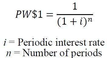
However, it is generally unnecessary to manually calculate the Present Worth of One factor using the above formula. The calculation can easily be done on a financial calculator or as a formula in a computer spreadsheet program. The Present Worth of One factor can also be obtained from compound interest tables.
If review of the payment amounts over the remaining term of the agreement indicates that the payment will be identical for each year, use of a present worth of one per period factor based on the conversion rate and remaining years may be used in place of the present worth of one factor.
Level of Value Adjustment Factor
Pursuant to § 39-1-103(17)(a)(I) and (II)(B), C.R.S., the administrator is required to establish the level of value (LOV) adjustment factor(s) for possessory interests using the same procedures and principles as are provided for property in § 39-1-104(12.3)(a)(I), C.R.S. For each assessment year, the Division of Property Taxation publishes a separate LOV adjustment factor for real and personal property possessory interests.
For each tax year, the Division utilizes the U.S. Department of Labor, Bureau of Labor Statistics data changes to the CPI-U: Denver- Boulder-Greeley from appraisal date to assessment date to calculate the LOV factor. Please refer to Addendum 7-D, Possessory Interest Valuation Rates for the adjustment factor to be used for the current assessment year.
Steps to Value Commercial Possessory Interest
As required by § 39-1-103(17)(a)(II), C.R.S., the actual value of commercial possessory interests is determined by the present value of the reasonably estimated future annual rents or fees required to be paid by the holder of the possessory interest to the owner of the underlying real or personal property through the stated initial term of the agreement.
Steps in the valuation process:
Step #1 Contact the appropriate federal, state, or local agency or entity to obtain information regarding the agreement.
Use the list provided by the Division for the federal and state agencies. The items on the list include names, mailing addresses, annual payments, terms and the original date and/or the expiration date of the agreement. If you have any questions regarding information contained on the list, refer to Discovery of Possessory Interests for the name, address, and phone number of the applicable
agency.
In the event that property owned by a governmental entity other than federal or state land is used for commercial purposes by a private party, the county is responsible for obtaining the necessary documentation.
Step #2 Develop the applicable NPV conversion rate.
Calculating the applicable net present value conversion rate:
Discount Rate (calculated by the county) + Effective Tax Rate (calculated by the county) = NPV Conversion Rate
For additional information regarding how discount rates for commercial possessory interest properties are developed, refer to Development of the Discount Rate for Commercial Possessory Interests. For the formula used in calculating an effective tax rate, refer to Development of the Effective Tax Rate.
Step #3 Determine the present worth of one factor.
For each year remaining in the agreement, determine the appropriate present worth of one factor in the compound interest tables based on the net present value conversion rate previously established by the county.
For possessory interests that have a duration of one year or less, the payment is the present worth. If this is the case, proceed to Step #5.
Step #4 Calculate the present value of the payments over the remaining years in the initial term of the agreement.
Conversion of the annual payments to present value is calculated by multiplying each year’s payment by the applicable present worth of one factor based on the previously determined NPV conversion rate. The calculation is completed for each of the remaining years in the initial term of the agreement. Add each year’s present value together for the total NPV of the possessory interest.
Example calculation of a commercial possessory interest:
Assumptions:
- Remaining years of income stream 4 years
- Net present value conversion rate including ETR 14%
- Annual payment (less exclusions) for remaining years in the agreement
- Year #1 $10,000
- Year #2 $11,000
- Year #3 $12,000
- Year #4 $13,000
Calculation of NPV:
| Year #1 | Year #2 | Year #3 | Year #4 | |
|---|---|---|---|---|
| Annual payment (less exclusions) | $10,000 | $11,000 | $12,000 | $13,000 |
| PW of 1 Factor for 14% | 0.877193 | 0.769468 | 0.674972 | 0.592080 |
| Net Present Value of payment | $8,772 | $8,464 | $8,100 | $7,697 |
The net present value for each remaining year in the agreement is totaled to arrive at the NPV of the possessory interest. Simply stated, $33,033 is the value today of the total payments over the remaining years in the agreement.
Step #5 Apply the level of value adjustment factor published by the Division.
The calculation of the actual value of the possessory interest is:
NPV of the possessory interest x Level of value adjustment factor (published by the Division) = Actual value of the possessory interest
Agricultural Possessory Interest Valuation
Land owned by a governmental entity and used through an agreement for farming or ranching by a private individual is a taxable possessory interest. Agricultural possessory interests are valued in accordance with § 39-1-103(17)(a)(II), C.R.S. Senate Bill 04-059 established, as of January 1, 2005, that the actual value of a possessory interest in agricultural land, including land leased by the state board of land commissioners other than land leased pursuant to § 36-1- 120.5, C.R.S., shall be the actual amount of the annual rent paid for the property tax year.
Data Needed
- Actual rent paid in the agreement
- Current year level of value adjustment
Obtaining Necessary Information
For information on how to contact the respective agency for a list of necessary information for use in classification and valuation of possessory interests, refer to Discovery of Possessory Interests.
Level of Value Adjustment Factor
Pursuant to § 39-1-103(17)(a)(I) and (II)(B), C.R.S., the administrator is required to establish the level of value adjustment (LOV) factor(s) for possessory interests using the same procedures and principles as are provided for property in § 39-1-104(12.3)(a)(I), C.R.S. For each assessment year, the Division of Property Taxation publishes a separate LOV adjustment factor for real and personal property possessory interests.
For each tax year, the Division utilizes the U.S. Department of Labor, Bureau of Labor Statistics data changes to the CPI-U: Denver-Aurora-Lakewood from appraisal date to assessment date to calculate the LOV factor. Please refer to Addendum 7-D, Possessory Interest Valuation Rates for the adjustment factor to be used for the current assessment year.
Steps to Value Agricultural Possessory Interests
As required by § 39-1-103(17)(a)(II), C.R.S., the actual value of a possessory interest in agricultural land, including land leased by the state board of land commissioners other than land leased pursuant to § 36-1-120.5, C.R.S., shall be the actual amount of the annual rent paid for the property tax year.
Steps in the valuation process:
Step #1 Contact the appropriate federal, state, or local agency or entity to obtain information regarding the agreement.
Use the list provided by the Division for the federal and state agencies. The items on the list include names, mailing addresses, annual payments, terms and the expiration date of the agreement. If you have any questions regarding information contained on the list, refer to Discovery of Possessory Interests for the name, address, and phone number of the applicable agency.
In the event that property owned by a governmental entity other than federal or state land is used for agricultural purposes by a private party, the county is responsible for obtaining the necessary documentation.
Step #2 Determine the actual value.
The actual rent paid for each agreement is the actual value.
Step #3 Apply the level of value adjustment factor published by the Division.
The calculation of the actual value of the possessory interest is:
Actual value of the possessory interest (rent paid) x Level of value adjustment factor (published by the Division) = Actual Value of the Agricultural Possessory Interest
Ski Area Possessory Interest Valuation
Section 39-1-103(17)(a)(I), C.R.S., specifically requires that the valuation of ski area possessory interest is determined by capitalizing at an appropriate rate the annual fee paid by the lessee or permittee. The rate used to capitalize any fee paid by the ski area includes an appropriate capitalization rate, an appropriate effective tax rate and an appropriate adjustment to reflect the portion of the fee, if any, required to be paid over by the United States to the state of Colorado and its political subdivisions.
The possessory interest valuation method is applied only to the real and personal property under agreement from the United States. Privately owned land, improvements, and personal property located on the property are separately valued considering the cost, market and income approaches to appraisal.
Capitalization of Income Definition
The previous year’s fees paid for the use of the USFS land for a ski area is capitalized into a value of the possessory interest.
Data Needed
- Previous year’s permit fees
- Capitalization rate
- Pass-through rate
- Effective tax rate as of the assessment date
- Current year level of value adjustment
Obtaining Ski Area Permit Fees from USFS
The division annually collects the ski area permit fees from the USFS or counties can contact the ski area directly.
Capitalization Rate Development
The capitalization rate is developed and published by the Division every year using the Weighted Average Cost of Capital technique (WACC) and may be found in Addendum 7-D, Possessory Interest Valuation Rates. For more detailed information on the calculation of the ski area capitalization rate contact the Division.
Pass-Through Rate Development
The pass-through component of the ski area capitalization rate represents the twenty-five percent of fees returned to the state by the U.S. Forest Service (USFS) from fees paid by users of USFS land. The pass-through rate may be found in Addendum 7-D. For more detailed information on the calculation of the ski area pass-through rate contact the Division.
Effective Tax Rate Development
The effective tax rate is developed by the county to account for property taxes paid by the possessory interest owner of the ski area recreational land for the possessory interest assessment. In the calculation, the county uses the mill levy prior to the assessment date for the tax area where the ski area is located.
Mill Levy (as a decimal; based on location of the possessory interest) X 0.29 (assessment rate as a decimal) = Effective Tax Rate (expressed as a decimal equivalent)
Adjusted Capitalization Rate Calculation
The adjusted capitalization rate is composed of three components.
Capitalization rate (calculated by the Division) + Pass-through rate (calculated by the Division) + Effective tax rate (calculated by the county) = Adjusted Capitalization Rate
Adjusted Capitalization Rate Application
After the adjusted capitalization rate is calculated it is applied to the USFS previous year’s fee amount. The resulting number is the actual value of the possessory interest in the Forest Service land.
Fees paid to USFS (from USFS) ÷ Adjusted Capitalization rate (developed by the county and the Division) = Value of the possessory interest
Level of Value Adjustment Factor
Pursuant to §39-1-103(17)(a)(I) and (II)(B), C.R.S., the administrator is required to establish the level of value (LOV) adjustment factor(s) for possessory interests using the same procedures and principles as are provided for property in § 39-1-104(12.3)(a)(I), C.R.S. For each assessment year, the Division of Property Taxation publishes a separate LOV adjustment factor for real and personal property possessory interests.
For each tax year, the Division utilizes the U.S. Department of Labor, Bureau of Labor Statistics data changes to the CPI-U: Denver-Aurora-Lakewood from appraisal date to assessment date to calculate the LOV factor.
Please refer to Addendum 7-D, Possessory Interest Valuation Rates for the adjustment factors to be used for the current assessment year.
Steps to Value Ski Area Possessory Interests
Section 39-1-103(17)(a)(I), C.R.S., requires that the assessor use only the capitalization of income approach to determine the value of the possessory interest of ski area recreational lands.
Steps in the valuation process:
Step #1 Obtain the amount of fees paid for the previous calendar year.
Use data collected by the Division and provided to the counties or contact the United State Forest Service (USFS) district forest supervisor’s office in which the ski area is located. If unsure as to where the local office is, refer to Discovery of Possessory Interests for the name and address of the central office.
Step #2 Develop the applicable adjusted capitalization rate.
Calculate the applicable adjusted capitalization rate:
Capitalization rate (calculated by the Division) + Pass-through rate (calculated by the Division) + Effective tax rate (calculated by the county) = Adjusted Capitalization Rate*
*The capitalization rate should be rounded to four (4) decimal places.
Additional information regarding how the discount and pass-through rates are developed may be obtained by contacting the Division of Property Taxation.
Step #3 Calculation of the actual value of the possessory interest.
Example calculation of ski area recreational land:*
Assumptions:
Previous Year’s USFS fees $50,000
| Capitalization Rate (published by the Division) | + 0.1300 |
|---|---|
| Pass-through rate (published by the Division) | + 0.0430 |
| Effective tax rate (calculated by the county) | + 0.0232 |
| Adjusted capitalization rate (expressed as a decimal) | 0.1962 |
Calculation of Value:
| Previous Year’s USFS fees | $50,000 |
|---|---|
| Adjusted Capitalization Rate | ÷ 0.1962 |
| Value of the possessory interest | $254,842 |
* Note: the above calculations are examples and do not necessarily reflect the published ski area capitalization rate and pass-through rate for the current tax year. See Chapter 7, Addendum 7-D, for the current year rates and factors.
Step #4 Apply the level of value adjustment factor published by the Division.
The calculation of the actual value of the possessory interest is:
Capitalized value of the possessory interest X Level of value adjustment factor (published by the Division) = Actual Value of the possessory interest
The Division publishes the capitalization rate and pass through rate used by all county assessors each year. For intervening assessment years (even numbered years), the Division publishes the adjustment factor used by all assessors to adjust values to the appraisal date in effect for that reappraisal cycle.
Administrative Issues
Apportionment Between Two or More Counties
In most circumstances, possessory interests are located in a single county and no apportionment is necessary. However in some instances, land under agreement lies in more than one county and thus requires an apportionment of the actual value of the possessory interest to each county.
In the case of agricultural grazing possessory interests, the federal and state agencies have been able to provide the exact acreage of each allotment within each county.
In the case of river-rafting permits the launch site location is to be used in determining the county as well as the taxing district to assign to the account.
For guide and outfitter operations or USFS special use permits located in multiple counties it would be reasonable to assign the base-site of the operation as the location. It is up to each county to communicate with the shared counties to determine the apportionment.
Each county will send a tax bill for its apportioned share of the total value.
Tax Area Assignment
Possessory interest properties will be taxed by a minimum of the county and a school district. The inclusion of property in other taxing entities must be determined using county and taxing entity records, to the best of your ability.
School district boundary information is available from the school district and/or the Department of Education.
When assigning a tax area for possessory interests such as a rafting operation, it would be reasonable to use the location of the launch-site as the determinate factor for establishing the tax area or in the case of multiple counties, the county/tax area where the launch-site is located. The same theory would be reasonable regarding guide and outfitter operations, e.g., the county where the business is based. However, all counties involved need to be in agreement with this assignment.
Minimum Value
The law does not provide for minimum assessments on real or personal property. What is allowed pursuant to § 30-1-102(3), C.R.S., is the collection of a $5 administrative fee when a real property tax amount is less than $10.
Counties considering a minimum assessment should discuss the issue with the county attorney, as the county attorney defends the assessor’s actions if a taxpayer challenges the minimum value.
Property Description
The property description for a possessory interest will vary, depending on the information available and whether the lessor is the U.S. forest Service, the State Land board, etc. Based on the information available from each lessor, the assessor should establish a standard for possessory interest descriptions. Below are suggested items that might be included, if available, in the description.
- Principal meridian (if there is more than one survey area in the county)
- Section, township and range
- Lease/permit/authorization number
- Lessor
- Contract date (optional)
- Expiration date (optional)
- Park name/allotment name
- Acreage of parcel (if known)
Examples:
Possessory interest in State Land Board land in Section 36, Township 11 North, Range 52 West of the 6th Principal Meridian, containing 640 acres, per lease number 01123.
Possessory interest in BLM land, authorization number 0505715, allotment Westridge.
Parcel Numbering
A parcel number may be assigned to a possessory interest property but because the possessory interest is tied to a permitted use and not necessarily to real property described by section, township, and range using a fourteen-digit parcel number may not be appropriate.
Therefore, to create consistency, a county could consider using arbitrary schedule numbers to identify possessory interest properties.
Abstract of Assessment
The possessory interest values are listed by class for each city and town and school district in the abstract. Specific abstract codes to be used are found in ARL Volume 2, Chapter 6, Property Classification Guidelines and Assessment Percentages, Property Class and Subclass Descriptions.
Collection of Taxes
As per § 39-1-107, C.R.S., the property tax on a possessory interest in real or personal property that is exempt from taxation must be assessed to the holder of the possessory interest and collected in the same manner as property taxes assessed to owners of real or personal property; except that such property tax cannot become a lien against the property. When due, the property tax will be a debt due from the holder of the possessory interest to the board of county commissioners where the property is located or to such other body as is authorized by law to levy property taxes, and will be recoverable by the board or body by direct action in debt on behalf of each governmental entity for which a property tax levy has been made.
The debt action would be initiated by the treasurer and would involve the county commissioners and county attorney.
Exemptions Granted by the Property Tax Administrator
The Property Tax Administrator (PTA) has the authority to grant property tax exemptions to privately owned property that is used solely and exclusively for religious purposes, for private schools, or for strictly charitable purposes. Possessory interests can be granted exemption by the PTA under these guidelines.
Applications for exemption must be submitted to the PTA. The PTA reviews each application to determine whether the exemption is justified and in accordance with the intent of the law. Statute restricts property tax collection efforts while an application is pending.
Section 39-2-117(1)(a)(II), C.R.S., states “On all properties for which an application is pending in the office of the administrator, taxes shall not be due and payable until such determination has been made. Such property shall not be listed for the tax sale, and no delinquent interest will be charged on any portion of the exemption that is denied.”
To aid counties in complying with this restriction, no later than June 1 of each year the Administrator shall provide to the assessor, treasurer, and board of county commissioners of each county a list of all applications pending within their county, § 39-2-117(1)(a)(III), C.R.S. Please see Assessors’ Reference Library Volume 2, Chapter 3, Specific Assessment Procedures for more information.
In some cases, application for exemption may not be necessary if the possessory interest does not exhibit “significant incidents of private ownership.” Please see previous discussion of Vail Associates for more information.
Transaction Adjustments
Transactional adjustments are made to account for differences in sales prices resulting from atypical terms of the sale. Transactional adjustments may include adjustments for real property rights, financing terms, conditions of sale, expenditures made immediately after purchase, and non-realty items.
In a mass appraisal sales confirmation program certain transactional adjustments are always considered, while others are rarely used. The removal of non-realty items from the sales price is regularly done. Atypical financing adjustments are rarely used unless they are identified through outlier sales ratios and are necessary for the setting of accurate values.
Outliers are defined as properties with very high or very low sales ratios. They may be caused by inaccurate appraisals, sales that were not arm’s length transactions, an inventory of a property’s characteristics that was not an accurate description of the property on the date of sale, data input errors, special incentives included with the sale, or atypical financing. Outliers usually indicate some form of atypical situation or motivation that causes a sale to be outside the typical market range of values.
Real Property Rights
An adjustment for conveyance of real property rights is not often made in Colorado ad valorem valuation. [An exception to this occurs where a property is encumbered with a long-term nonmarket lease, City and County of Denver v. BAA and Regis Jesuit Holding, Inc., 848 P.2d 355, (Colo. 1993)].
Financing Terms
The adjustment for financing terms not typical of the market is referred to as cash equivalency. The requirement for this adjustment is more prevalent in an oversupplied market where buyers, sellers, and lenders use creative financing. There are a variety of situations where a financing adjustment may be required.
- Cash Equivalency
The Uniform Standards of Professional Appraisal Practice (USPAP) requires that the terms of sale (e.g., cash, cash equivalent, or other terms) must be considered when developing an opinion of value.
When the market is out of equilibrium, sellers will sometimes offer buyers incentives to facilitate the sale. It is widely accepted that seller incentives can affect the sale price. The theory of this practice is that these incentives will result in a higher sales price. When this occurs the sales price reflects the value of both the real property and the incentives. Therefore, when estimating the market value of the real property the sales price must be adjusted for value of these incentives. The result will be the price paid for the property unaffected by special or creative terms.
Types of incentives have varied over the years. In the 1980’s, when mortgage interest rates were in the mid- to high-teens, seller financing at below market rates was often provided to help facilitate a sale. In recent years, incentives have changed to include seller assisted down payments, 100 percent loans, seller paid points, owner carried second mortgages, and cash payouts. Additional items such as home upgrades, landscaping, appliances, TVs, cars, or prepaid fees have also been given.
A cash equivalency adjustment should be considered when the seller does not receive the full cash proceeds or receives excessive cash proceeds at time of sale. The preferred method for making any market adjustment to a sale is by paired sales analysis. A comprehensive sales confirmation program is essential for development of cash equivalency.
- Seller Assisted Down Payments
Historically, FHA required that the down-payment come from the borrower’s own funds. Nehemiah Corporation of America first introduced the down-payment assistance concept in 1994. Nehemiah’s concept was to have the seller contribute a percent of the sales price to a nonprofit organization who would donate the down-payment to the buyer. When a buyer participates in a down-payment assistance program, the recorded sales price is adjusted upward to offset the contribution that the seller makes to a nonprofit organization.
Example:
A home was listed for $120,000 with down-payment assistance available. The buyer offers $132,000. The seller donates $12,000 ($132,000 contract price less $120,000 list price) to a nonprofit organization who then writes a check to the buyer for the $12,000 (minus fees) for “home buying assistance.” The buyer uses the $12,000 as their down payment. The seller receives their full list price of $120,000. The mortgage loan amount is based on the contract purchase price of $132,000. The obvious problem is that the market value of this property is not the contract purchase price of $132,000. The true market value of this property is the price the seller actually received of $120,000.
Even though the buyer and seller do not disclose the down payment assistance, when a sales price is higher than the original list price, this may be an indication that a seller assisted down-payment program was utilized and that further research is warranted.
Seller-Paid Points
An adjustment for seller-paid points is one cash equivalence adjustment that is relatively easy to calculate.
With respect to a mortgage loan, points are described as: “A percentage of the loan amount that a lender charges a borrower for making a loan; may represent a payment for services rendered in issuing a loan or additional interest to the lender payable in advance; also called loan fee.” The Dictionary of Real Estate Appraisal, 7th Edition, Appraisal Institute, 2022.
It is not uncommon in some markets for home sellers to pay points. If the transaction being analyzed involved seller-paid points in an amount that is typical of the market, then no adjustment is required. The problem occurs when a seller pays an atypically large amount of points. Where this is the case, an adjustment is required.
Example:
Transaction Adjustment: Seller-Paid Points
Total Sales Price (Documentary Fee) $120,000 Down Payment (20,000) Principal Financed $100,000 Points paid by seller: 3% = $3,000
Atypical Financing
When confirming sales for a universe of properties, outlier ratios are evidence that atypical financing may exist. Further research into this issue may be warranted and an adjustment may be appropriate if that sale is necessary for the setting of values.
Historically, loans had no relationship to the seller. Third-party financial institutions provided terms for loans that were not affected by the underlying price the seller receives. Now many of the nation’s homebuilders have their own mortgage companies that participate in the financing along with the third-party institutions. Sometimes, various creative financing terms are used to qualify buyers including high loan-to-value ratios, discounted interest rates, interest only loans, adjustable interest rates, and extended amortization periods. The sale price used to determine market value needs to be expressed in terms of cash that a typical investor or buyer would pay. Calculating the cash-equivalent price requires an appraiser to compare transactions involving atypical financing to transactions involving comparable properties financed at typical market terms.
When a financing adjustment is necessary, extreme caution should be applied in developing the adjustment. The appraiser needs to understand what typical financing terms are when deciding if the actual financing involved any special advantages or disadvantages. The most typical and easily identifiable is preferential financing. Factors to review may include: loan to value ratios, interest rates, amortization periods, terms of a balloon payment, and the frequency of payments. Nonmarket financing plans can be converted into terms that represent the cash equivalent price paid to the seller as of the date of sale.
Example:
Transaction Adjustment: Below Market Interest Rate
Total sales price (documentary fee) $200,000 Down payment (10,500) Principal financed $189,500
Contract Mortgage Terms:
Amortization Term 30 yrs, monthly payments
Interest rate 6 %
Market Mortgage Terms:
Amortization Term 30 yrs, monthly payments
Interest rate 10%
Contract monthly payment (6%, 30 yrs, $189,500) $ 1,136.15
Total value of loan (10%, 30 yrs, $1136.15) $129,465.02 Down payment (added back in) + 10,500 Total adjusted sales price $139,965 Rounded $140,000
Note: Using monthly compound interest tables to determine figures may cause slight variations in final values due to rounding.
Another way to estimate the adjustment for the below market financing is to determine the present worth of the difference in monthly payments between the contract payment amount and the market payment amount. This difference should be discounted at the market interest rate and over the total term of the mortgage.
Contract monthly payment: $1,136.15
Market monthly payment: $1,663.00
Difference: $526.85
PW of 1/Period for 30 years at 10%: 113.950820
Financing Adjustment: $60,035
Conditions of Sale
Conditions of sale refer to motivations and/or situations of the buyer and/or seller at the time of the transaction. Examples include; short marketing times, financial duress, related-party sales, or any atypical motivation on the part of either party. A market supported adjustment may be made based on the type of condition. However, these conditions usually cause a sale to be disqualified for ad valorem valuation and are typically never used to set values.
Expenditures Made Immediately After Purchase
Similar to conditions of sale, expenditures made immediately after a purchase usually cause a sale to be disqualified for the use in setting values for ad valorem purposes. The sale price of a property typically reflects its condition and quality at that time. When expenditures or upgrades change the condition or quality of the property, the sale price no longer reflects what was actually sold. A market supported adjustment may be made to reflect these changes. However, these sales are typically disqualified because the property characteristics in the CAMA system do not reflect the quality and condition of the property represented by the recorded sale price.
Non-Realty Items
Incentives that consist of non-realty components such as personal property, business value, or other non-realty interest should be analyzed and subtracted from the sales price to determine the price attributable only to the real property. If the seller and buyer agree on a total price that includes non-real estate items, the appraiser must determine the cash amount that the seller received for these items. Typical items of personal property that may be part of a residential transaction include: a plasma television, appliances, furniture, vehicles, vacation trips, and prepayment of homeowner fees and/or special assessments by the homeowners association.
Measuring and Testing the Accuracy of Transaction Adjustments
After developing transactional adjustments, the accuracy and validity of the adjustments should be tested. Sales that have been adjusted for cash equivalency should be separately stratified for statistical analysis and the setting of values.
Sales in which the seller receives the full sale proceeds in cash, either by way of a financial institution or directly from the buyer, are typically the best measure of accuracy. Through sales ratio analysis, these sales will support or invalidate the financing adjustments made to cash-equivalent sale prices based on their median sales ratio compared to that ratio of the non-transactional adjusted selling prices. Refer to Chapter 8, Statistical Measurements, for additional information on sales ratio and other statistical analysis techniques.
Addendum 7-A, Hotel or Motel Mixed-Use Questionnaire
Addendum 7-A, Hotel or Motel Mixed-Use Questionnaire
Addendum 7-B, Gov’t-Assisted Housing Questionnaire
Addendum 7-B, Government-Assisted Housing Questionnaire
Addendum 7-C, Formal Opinion of the Attorney
General
Addendum 7-C, Formal Opinion of the Attorney General
Addendum 7-D, 2024 Possessory Interest Valuation Rates
Ski Area Capitalization Rate
The pass-through component of the ski area capitalization rate represents the twenty-five percent of fees returned to the state by the U.S. Forest Service (USFS) from fees paid by users of USFS land.
Capitalization Rate 14.00 percent (Determined by the Division) + Pass-Through Rate 4.70 percent (Determined by the Division) + Effective Tax Rate (Determined Locally) = Adjusted Capitalization Rate
Level of Value Adjustment Factor
Pursuant to § 39-1-103(17)(a)(II)(B), C.R.S., the actual value of a possessory interest shall be adjusted to the taxable level of value (LOV) using a factor or factors to be published by the administrator pursuant to the same procedures and principles as are provided for personal property in section 39-1-104(12.3)(a)(I), C.R.S.
Possessory Interest LOV Factor: 0.93
Statistical Performance Analysis
The beginning, intermediate, and final step in ad valorem appraisal is to conduct statistical performance analyses. These analyses use descriptive statistics to measure central tendency and to measure the relative variability of data about the measure of central tendency. These measures are then compared to the acceptable measurement ranges for statistical compliance established by the State Board of Equalization (state board). Assuming the statistical sample size is adequate, measures that fall outside the acceptable ranges indicate that additional appraisal work is needed to discover what has caused outlier values to occur.
It is recommended that preliminary statistical analysis be completed before the initial reappraisal plan is developed. This analysis can identify property classes, subclasses, economic areas, and other property strata, e.g., price range, size, age, quality, condition, and design, most in need of appraisal attention. Statistical analysis is also the final step in ensuring the overall accuracy of reappraised values. Statistical analysis is a measurement of the success of a reappraisal.
In evaluating vacant land, residential improved, and commercial/industrial improved classified property values in Colorado, the following measures frequently are used:
- Measures of Central Tendency
- Median assessment ratio (primary measurement)
- Mean assessment ratio
- Weighted mean assessment ratio
- Measures of Relative Variability
- Coefficient of dispersion (primary measurement)
- Standard deviation
- Coefficient of variation
- Measure of Assessment Bias
- Price related differential (primary measurement)
- Measure of Confidence in Statistical Results
- Confidence interval
Sampling Techniques and Sample Size
A sample is a data set drawn from a population. Most market analysis and statistical analysis procedures rely on sampling because of the time and expense attempting to obtain data on all items in the population. If the sample is properly drawn and it represents the population, sampling can be a reliable market and statistical analysis tool.
Two basic types of sampling are probability sampling and nonprobability sampling. Probability sampling is one in which every item in the population has an equal chance of being selected. Probability sampling includes random, systematic, stratified, and cluster sampling techniques. For the most part, assessors will use random and stratified sampling in determining market and statistical analyses.
Selecting a random sample involves assigning every element in the population a number and choosing the sample by using a random number table generated either by computer or contained in a random number book.
For example, an assessor wants to determine if a complete physical inspection of every residential property is necessary to properly value all residential property in the county. The assessor should develop a random sample of properties on which to make a personal field inspection to compare existing property inventories with what is actually in place. Depending on the number of mistakes and omissions that exist, the assessor may determine that a complete physical inspection is necessary or only a cursory drive-by review can suffice.
Stratified samples are gathered from a population that is stratified by some characteristic and each stratum is randomly sampled.
A nonprobability sample is one in which not every item of the population has an equal chance of being included. Examples of nonprobability samples include quota and judgment samples. Nonprobability sampling techniques are most commonly used in advertising and business economics decision making. Nonprobability sampling is not recommended in ad valorem work.
Two limitations of sampling are sampling error and bias.
Sampling error is a relative measure, determined by a probability analysis, that the sample is not representative of the population. A sample must be drawn and weighted so that the characteristics of the sample represent or "mirror" the characteristics of the population as close as possible. For example, one area of the county has 60% of the residential improved sales, but only 25% of the population of residential improved parcels. If an assessor were to rely on paired sales in this area only to determine a time trend analysis applicable to the entire county, the resulting time trend factor might be nonrepresentative of the effect of time on all residential properties in the county.
Bias is the incorrect estimation of population characteristics from a poorly designed or executed sample. For example, a county mails an income questionnaire to all commercial businesses in order to ascertain market lease rates. Even though only 10% of the commercial property owners return the questionnaire, the assessor uses this data to determine income values for all commercial property in the county. Bias can exist because of the possibility of only property owners that charge low lease rates returned the questionnaire.
Another possibility of bias results from the failure of the designer of the sample selection technique to provide that every property in the population has an equal chance of appearing in the sample.
For example, an assessor mails out income questionnaires only to his friends and people that have indicated they would fill them out. Although the questionnaire return rate would be very high, the sample likely would be biased because not all commercial property owners would be provided the opportunity to respond.
A properly designed and completed random sample is one of the best ways of ensuring equal representation in the sample of population characteristics. Sample size generally depends on two factors:
- The economic value obtained in the sample
- The cost of sampling
Sample size estimation techniques such as sample mean, standard error of the mean, and standard error of the proportion are all used to determine appropriate sample sizes depending on the desired level of accuracy. However, these techniques are beyond the scope of this section. Please refer to a basic statistics text for additional information on these techniques.
As a general rule for property valuation analysis, the sample size should be sufficient so that the sample is representative of all major value influences affecting the property. Section 39-1- 103(8), C.R.S., details specific sample size limitations and requirements for sales ratio analysis and market analysis for property tax purposes.
Measures of Central Tendency
The three measures of central tendency used in assessment ratio studies are the mean, median and weighted mean. All three measure the tendency of values, i.e., the observed data, to cluster about a central, or representative, value.
Mean
The mean is defined as the arithmetic average of the data elements, e.g., the actual values or sales ratios in a class of property or in a stratification of property. The mean is calculated by adding all of the appropriate values or sales ratios together and then dividing by the number of the data elements summed, i.e., the number of observed ratios.
Median
The median is defined as the value or sales ratio that divides the data elements being analyzed into two halves, with each half containing the same number of observations. It is calculated by listing the data from high to low (or low to high), i.e., arraying the data, and picking the exact middle data element. If there is an even number of data elements (ratios), the median is the average of the two middle data elements.
Weighted Mean
The weighted mean ratio, or aggregate mean ratio, or weighted ratio, is defined as the ratio of the total actual values to the total sales prices in a group. It is calculated by dividing the total actual value of all properties in the subclass or other stratification of properties by the total of the sales prices of those properties. Although a weighted mean could be calculated for any set of data elements, it has been narrowly defined here to apply to ratio studies. The weighted mean measures assessment level on a dollar-by-dollar basis whereas the mean and median do so on a property-by-property basis.
In assessment ratio studies, the median is generally used in measuring assessment level. The median is least affected by a non-normal, i.e., skewed, distribution of data and is least affected by "outlier" data.
Example:
Using the Mean, Median, and Weighted Mean, in Analyzing Typical Commercial Land Sales
| Actual Values | Sales Prices | Ratios* | Arrayed Ratios** |
|---|---|---|---|
| $ 58,900 | $ 65,000 | 0.9062 | 0.7600 |
| 399,500 | 450,000 | 0.8878 | 0.7700 |
| 76,000 | 100,000 | 0.7600 | 0.8067 |
| 742,500 | 750,000 | 0.9900 | 0.8800 |
| 590,000 | 600,000 | 0.9833 | 0.8878 |
| 385,000 | 500,000 | 0.7700 | 0.9062 |
| 800,000 | 800,000 | 1.0000 | 0.9833 |
| 88,000 | 100,000 | 0.8800 | 0.9900 |
| 1,050,000 | 1,000,000 | 1.0500 | 1.0000 |
| 242,000 | 300,000 | 0.8067 | 1.0500 |
| $4,431,900 | $4,665,000 | 9.0340 | 9.0340 |
* Ratio calculated by dividing actual value by sales price.
** All ratios must be arrayed prior to statistical analyses.
Mean Ratio = (9.0340 ÷ 10) = 0.90340 or 90.34%
Median Ratio = (0.8878 + 0.9062) ÷ 2 = 0.8970 or 89.70%
Wtd Mean Ratio = ($4,431,900 ÷ $4,665,000) = 0.9500 or 95%
The state board statistical compliance standards for the level of value for vacant land, residential improved, and commercial/industrial improved classified properties are 95 percent to 105 percent as measured by the median sales ratio.
Measures of Relative Variability
When measures of central tendency are calculated, a single number results. That number represents an entire group of values. However, this number cannot be determined to be truly representative of the group without an indication of the relative distance, or spread, of the data elements from the measure of central tendency. This spread, often called dispersion or variability, is generally measured in assessment ratio studies by the coefficient of dispersion. When using a measure of relative variability, the smaller the coefficient number, the more uniformly assessed are the properties.
Coefficient of Dispersion
Relative variability statistics allow for comparisons within groups of data, such as the ratios which occur when actual values are divided by sales prices.
The coefficient of dispersion (COD) is defined as the measure of the spread of values about the median value. It is calculated by dividing the average absolute deviation from the median by the median. The average absolute deviation is calculated by summing the sign-ignored, i.e., absolute, differences between the median ratio and each of the arrayed ratios and dividing the resulting amount by the number of ratios in the sample being analyzed.
In assessment ratio studies, the COD is generally considered the primary indicator of quality within a mass appraisal project. This is because assessment ratios are not normally distributed. Since there are lower limits beyond which marketplace property values will not fall, the COD is considered more reliable and less prone to the effects of very high (skewed) values often found in property value distributions. In Colorado, the measures of dispersion considered acceptable by the state board are 20.99% or less for vacant land and commercial/industrial improved, and 15.99% or less for residential improved classified properties.
Example:
Using the COD.
| Actual Values | Sales Prices | Ratios* | Arrayed Ratios** | Median Ratio | Absolute Deviation |
|---|---|---|---|---|---|
| $ 58,900 | $ 65,000 | 0.9062 | 0.7600 | 0.8970 | 0.1370 |
| 399,500 | 450,000 | 0.8878 | 0.7700 | 0.8970 | 0.1270 |
| 76,000 | 100,000 | 0.7600 | 0.8067 | 0.8970 | 0.0903 |
| 742,500 | 750,000 | 0.9900 | 0.8800 | 0.8970 | 0.0170 |
| 590,000 | 600,000 | 0.9833 | 0.8878 | 0.8970 | 0.0092 |
| 385,000 | 500,000 | 0.7700 | 0.9062 | 0.8970 | 0.0092 |
| 800,000 | 800,000 | 1.0000 | 0.9833 | 0.8970 | 0.0863 |
| 88,000 | 100,000 | 0.8800 | 0.9900 | 0.8970 | 0.0930 |
| 1,050,000 | 1,000,000 | 1.0500 | 1.0000 | 0.8970 | 0.1030 |
| 242,000 | 300,000 | 0.8067 | 1.0500 | 0.8970 | 0.1530 |
| $4,431,900 | $4,665,000 | 9.0340 | 9.0340 | 0.8250 |
* Ratio calculated by dividing actual value by sales price.
** All ratios must be arrayed prior to statistical analyses.
Median Ratio = 0.8970 or 89.70%
Average Absolute Deviation = (0.8250 ÷ 10) = 0.0825
Coefficient of Dispersion = (0.0825 ÷ 0.8970) = 0.0920 or 9.20%
Based on the above COD statistic, the following statement can be made about the assessment uniformity of vacant land values in this economic area.
“While the COD statistic is less than 20.99% and land values are uniformly applied, the level of value (median sales ratio) is outside of the 95 percent to 105 percent compliance range. Both the level of value, as measured by the median sales ratio, and the uniformity of values, as measured by the coefficient of dispersion, should be within state board compliance standards before the price related differential statistic is calculated.”
Coefficient of Variation
The variance is defined as the mean of the squared deviations of the observations from their own mean value. It is calculated by determining the deviation from the mean for each data element, squaring each deviation and adding them together, and then dividing by the total number of observations in the data set.
Calculating the variance is the first step in calculating the standard deviation, and the standard deviation must be calculated before the coefficient of variation can be determined.
The standard deviation (sd) is defined as a measure of variability which provides a single numerical value to describe the distribution of data elements in a sample about the mean value of the sample. It is calculated by taking the square root of the variance. The standard deviation is a statistical measure of dispersion which is widely used when the sample has the characteristic of a normal distribution, i.e., a bell-shaped curve.
The coefficient of variation (COV) is defined as the measure, expressed as a percentage, of the spread of values about the mean value. It is calculated by dividing the standard deviation by the mean.
Example:
Using the Variance, Standard Deviation, and Coefficient of Variation.
| Actual Values | Sales Prices | Ratios* | Arrayed Ratios** | Mean Ratio | ABS DV | DEV SQRD |
|---|---|---|---|---|---|---|
| $ 58,900 | $ 65,000 | 0.9062 | 0.7600 | 9.0340 | 0.1434 | 0.0206 |
| 399,500 | 450,000 | 0.8878 | 0.7700 | 9.0340 | 0.1334 | 0.0178 |
| 76,000 | 100,000 | 0.7600 | 0.8067 | 9.0340 | 0.0967 | 0.0094 |
| 742,500 | 750,000 | 0.9900 | 0.8800 | 9.0340 | 0.0234 | 0.0005 |
| 590,000 | 600,000 | 0.9833 | 0.8878 | 9.0340 | 0.0156 | 0.0002 |
| 385,000 | 500,000 | 0.7700 | 0.9062 | 9.0340 | 0.0028 | 0.0000 |
| 800,000 | 800,000 | 1.0000 | 0.9833 | 9.0340 | 0.0799 | 0.0064 |
| 88,000 | 100,000 | 0.8800 | 0.9900 | 9.0340 | 0.0866 | 0.0075 |
| 1,050,000 | 1,000,000 | 1.0500 | 1.0000 | 9.0340 | 0.0966 | 0.0093 |
| 242,000 | 300,000 | 0.8067 | 1.0500 | 9.0340 | 0.1466 | 0.0215 |
| $4,431,900 | $4,665,000 | 9.0340 | 9.0340 | 0.0932 |
* Ratio calculated by dividing actual value by sales price.
** All ratios should be arrayed prior to statistical analyses.
Mean Ratio = (9.0340 ÷ 10) = 0.9034 or 90.34%
* Variance = (0.0932 ÷ 9*) = 0.0104
Standard Deviation = √0.0104 = 0.1018
Coefficient of Variation = (0.1018 ÷ 0.9034) = 0.1127 or 11.27%
*Variance is calculated using n-1 in order to remove sample bias.
Based on the above descriptive statistics, the following statements can be made about the assessment level of land values in this economic area:
- Assuming the desired assessment level is 100%, the land values are under-assessed.
- The closeness of the mean and median ratios indicates that this sample is relatively normally distributed.
- The difference between the mean and the weighted mean indicates that some bias exists towards lower valued properties. Further analysis using the price-related differential statistic should be undertaken to analyze assessment bias, after the problem with level of value has been corrected. This statistic is most helpful in determining which portion of the sample needs further appraisal work if the level of value is in compliance but the coefficient of dispersion is out of compliance.
Measure of Assessment Bias
After assessment level and uniformity have been reviewed and determined to be within compliance standards, the final analysis should be for assessment bias. The measure of assessment bias, i.e., the price related differential, is a measure of whether higher valued properties are over, or under-assessed, in relation to lower valued properties.
The price related differential (PRD) is defined as the ratio between the mean sales ratio and the weighted mean sales ratio for a group of properties. It is calculated by dividing the mean sales ratio by the weighted mean sales ratio.
The desired PRD ratio result is 1.00. This result indicates that no assessment bias exists between higher and lower valued properties. A ratio value of less than 1.00 indicates progressivity, in that higher valued properties are over-assessed in relation to lower valued properties. A ratio value of more than 1.00 indicates regressivity in that higher valued properties are under-assessed in relation to lower valued properties.
The recommended range of the PRD statistic is 0.98 to 1.03. An example of the use of the PRD statistic is shown below.
Example:
| Actual Values | Sales Prices | Ratios* |
|---|---|---|
| $ 58,900 | $ 65,000 | 0.9062 |
| 399,500 | 450,000 | 0.8878 |
| 76,000 | 100,000 | 0.7600 |
| 742,500 | 750,000 | 0.9900 |
| 590,000 | 600,000 | 0.9833 |
| 385,000 | 500,000 | 0.7700 |
| 800,000 | 800,000 | 1.0000 |
| 88,000 | 100,000 | 0.8800 |
| 1,050,000 | 1,000,000 | 1.0500 |
| 242,000 | 300,000 | 0.8067 |
| $4,431,900 | $4,665,000 | 9.0340 |
* Ratio calculated by dividing actual value by sales price.
Mean ratio = (9.0340 ÷ 10) = 0.9034
Weighted mean ratio = ($4,431,900 ÷ $4,665,000) = 0.9500
Price related differential = (0.9034 ÷ 0.9500) = 0.9509
Based on the above statistic, and assuming that the median ratio and COD are within compliance standards, the following statement can be made concerning assessment bias within land assessments in this economic area.
“The PRD indicates some assessment bias may exist against higher valued properties. The valuation of higher value properties should be reviewed to determine if the cause of assessment bias can be determined.”
After analyzing all the statistical tests on these land sales, the following conclusions can be reached:
- Unit values in the electronic appraisal system should be reviewed. The unit values currently used in the market approach are too low. The unit values in the valuation tables apparently were not calibrated to the sales sample.
- Higher valued properties should be reviewed to see if they are properly included in this economic area or if there are other causes of assessment bias.
All statistical tests need to be recalculated after making any changes. However, the final decision to accept any mass appraisal program is solely the responsibility of the assessor.
Confidence Interval
Measures of reliability identify the degree of confidence that can be placed in a calculated statistic. A confidence interval consists of a range of numbers that brackets a calculated measure of central tendency for the sample. The confidence interval identifies, with a certain degree of confidence (usually 95 percent), whether the true measure of central tendency for the population falls within the range. In mass appraisal, confidence intervals are typically calculated around the median sales ratio. For example, a confidence interval for the median sales ratio can be calculated to identify how accurately the sample median ratio approximates the true population median ratio. At any level of confidence, the size of the confidence interval is a function of the sample size and the distribution of sales ratios.
The median confidence interval is expressed in the following formulas:
When n is even
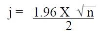
Or when n is odd
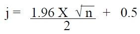
In both formulas, n is the sample size and j is an intermediate value that will be rounded to the next whole number.
By counting both up and down, using the rounded number from the median sales ratio, it can be stated with 95 percent confidence that the median sales ratio lies between these ratios. If the number of ratios in the sample is odd, count up and down beginning with ratios adjacent to the median ratio.
More specific information on the calculation and uses of the standard deviation, coefficient of variation, and confidence intervals can be found in the appraisal text titled Property Appraisal and Assessment Administration, 1990, IAAO. These same procedures can also be found in basic statistics texts at the local library.
State Board Performance Standards
In Colorado, all assessors are required to meet certain minimum statistical performance standards in appraising properties. The State Board of Equalization (state board) has adopted minimum statistical assessment standards and requires all assessors to achieve these standards for each assessment year. The standards are included in Addendum 8-A, State Board Compliance Requirements.
Failure to meet these standards may result in the following:
- A state board order for reappraisal.
- Reimbursement of state expenses relating to the cost of state supervision or assistance in implementing the state board ordered reappraisal.
- Pay back of any excess state aid to schools caused by an incorrect assessment level.
If additional information is needed about the understanding and use of statistics in mass appraisal, please refer to the Property Appraisal and Assessment Administration, 1990, and Standard On Ratio Studies, 2010, published by the International Association of Assessing Officers.
Addendum 8-A, State Board Compliance Requirements
The equitable and fair valuation of property requires the use of statistical analysis to monitor assessment level, uniformity, and assessment bias. The following requirements, recommendations, and optional measures are standards adopted by the State Board of Equalization (state board) and are benchmarks followed by the one percent assessment auditor. In addition, the information will assist the assessor in determining whether or not equitable and fair valuations have been achieved during a reappraisal.
Required Methodology
- All property classes and subclasses to be reappraised must be stratified by economic area. The state board's intent is written justification.
- The county must prepare a physical map(s) delineating economic areas resident in the county and the justification therefore. Each neighborhood associated with an economic area must be illustrated on a physical map.
- The county must, through computerization, appraisal records, or other means, be able to identify each property within the economic areas. Each property must be geographically identified by only one neighborhood and associated economic area. Economic areas are to be determined by analysis of homogeneous property characteristics, i.e., similar age, size, design, quality, sale price per square foot, etc.
- The number of observed sales ratios within each sample must meet or exceed the following sample requirements.
- An absolute minimum of 30 sales or appraisal ratios are required in each economic area or temporarily combined economic areas. The greatest number of calculated sales ratios available, given the constraints of sales data, time, and manpower, is recommended to be collected and analyzed.
- If 30 or more observed sales ratios are not available for a strata of property, the strata must be collapsed into a subclass. If insufficient ratios exist within a subclass, the subclass must be collapsed into a class. And if insufficient ratios exist within a class in a county, the sample for that class must be supplemented by sales and property characteristics from that class from a neighboring county.
State Board Statistical Compliance Requirements
- The assessment level of a reappraisal program must meet or exceed the following measures of level of value about the median sales ratio. The instructions for completing a median sales ratio calculation can be found earlier in this chapter.
- a. Vacant Land: 0.95 to 1.05
- Residential: 0.95 to 1.05 (Including condos and mobile homes)
- Commercial: 0.95 to 1.05
- Industrial: 0.95 to 1.05
- Agricultural: 0.90 to 1.10 (Including land, residences, but not support structures)
- Personal Prop.: 0.90 to 1.10 (Includes all personal property)
- Other: None
- The assessment quality of a reappraisal program must meet or exceed uniformity in values as measured by the coefficient of dispersion. The instructions for completing a coefficient of dispersion can be found earlier in this chapter.
- Vacant Land: 20.99 or less
- Residential: 15.99 or less (Including condominiums and mobile homes)
- Commercial: 20.99 or less
- Industrial: 20.99 or less
- Agricultural: 20.99 (Includes only Ag residences)
- Other: None
State Board Procedural Compliance Requirements
Subclasses to be subject to the assessment audit must include at least 20 percent of the valuation
of a class of property, unless otherwise noted.
- Vacant Land (All)
- Vacant land is eligible and may be subject to present worth valuation procedures established by the Division.
- Minimum number of parcels for a vacant land assessment audit in a county is 1,200.
- Residential (All)
- Only the market approach to appraisal is to be used.
- Commercial/Industrial (All)
- Cost, market, and income approaches to appraisal are to be used.
- Agricultural Land
- Use Chapter 5, Valuation of Agricultural Land, including current published base crops, expenses, and commodity prices.
- Use typical local expenses, which are documented and conform to the requirements found in Chapter 5, Valuation of Agricultural Land.
- Use NRCS soil surveys (if available) to identify classes of lands based on productivity capabilities.
- Use CASS yields and establish current crop rotation practices per CASS planted acreage.
- All expenses, income, yields, and cropping practices must reflect ten-year averages.
- Use statutory capitalization rate of 13 percent.
- Agricultural Residences
- Value is to be established using Chapter 5, Valuation of Agricultural Land, Agricultural Residential Improvements procedure for residences abstract coded as 4277, i.e., in the absence of sales data to the contrary, no adjustment factor other than factors applied to residences near city or town boundaries are to be used.
- Support (Rural) Structures
- Use Division procedures for valuing rural structures coded as 4279. Use standard inventory procedures and use only the cost approach to appraisal.
- Account for all structures whether salvage value has been applied or not.
- Natural Resources (All)
- Use Chapter 6, Valuation of Natural Resources, a random procedural check of a minimum of three schedules will be performed during the assessment audit.
- Personal Property (All)
- Use ARL VOLUME 5, PERSONAL PROPERTY MANUAL, including current discovery, classification, and documentation procedures, and including current economic lives table, cost factor tables, depreciation table, and level of value adjustment factor table.
- The county audit plan should be updated each year. The county audit plan must be feasible considering the county resources. The county will be evaluated by the independent auditor on the time schedule and adequacy of the audit plan.
- Aggregate ratio will be determined solely from the personal property accounts which have been physically inspected. The minimum assessment audit sample is 30 audited schedules (accounts). The level of value (median appraisal ratio) for personal property schedules analyzed must be between 90 and 110 percent.
State Board Supplemental Statistical Tests
The following statistical measures are not required by the state board, but are recommended as supplemental tests to provide additional confidence in appraised values.
- The assessment level of a reappraisal program should meet or exceed the following measures of level of value about the mean and aggregate (weighted) mean sales ratios. The instructions for completing a mean and weighted mean sales ratio can be found earlier in this chapter.
- Mean
- Vacant Land: 0.95 to 1.05
- Residential: 0.95 to 1.05
(Including condominiums and mobile homes) - Commercial: 0.95 to 1.05
- Industrial: 0.95 to 1.05
- Agricultural Except Support Structures 0.90 to 1.10
(Includes land, residences, and "other Ag." property)
- Aggregate (weighted) Mean
- Vacant Land: 0.95 to 1.05
- Residential: 0.95 to 1.05
(Including condominiums and mobile homes) - Commercial: 0.95 to 1.05
- Industrial: 0.95 to 1.05
- Agricultural Except Support Structures 0.90 to 1.10
(Includes land, residences, and "other Ag." property)
- Mean
- The assessment quality of a reappraisal program should achieve uniformity in values as demonstrated by meeting or exceeding the following measures of the Coefficient of Variation. Instructions for completing a coefficient of variation analysis can be found earlier in this chapter.
- Coefficient of Variation
- Vacant Land: 24.99 or less
- Residential: 19.99 or less
(Including condominiums and mobile homes) - Commercial: 24.99 or less
- Industrial: 24.99 or less
- Agricultural: 24.99 or less
(Includes residences)
- Coefficient of Variation
- The values within a class or subclass of property should exhibit a lack of bias against
lower or higher valued properties as measured by meeting or exceeding the following
measures of the Price-Related Differential as specified in Property Appraisal and
Assessment Administration, IAAO (1990) pg. 541. Instructions for completing a price
related differential can be found earlier in this chapter.- Residential: 0.98 to 1.03
- Commercial: 0.98 to 1.03
- Industrial: 0.98 to 1.03
Optional Statistical Tests
There are additional statistical tests that are available. More detailed instructions regarding the following optional tests can be found in the published text of Property Appraisal and Assessment Administration, 1990, IAAO.
- Other measures of assessment level include the following:
- Binomial Test - This test is to be used when sample size is less than 100. This test compares the number of observations actually falling in each of two categories with the number expected to fall in each category under the assumption that a stated hypothesis is true. The median appraisal ratio divides the number of observed sales ratios into two equal parts, to determine the correct level of value.
- Mann-Whitney Test - This test is an excellent non-parametric test of the null hypothesis that two classes or economic areas are assessed at the same percentage of market value, to measure the differences in level of assessment. This test seeks to determine whether the differences between two economic areas or classes are at the correct level of value.
- Kruskal-Wallis Test - This is a test that compares three or more property groups, e.g., economic areas or classes, to determine if they are assessed at equal percentages of market value, to measure differences in level of assessment. This test is similar to the Mann-Whitney Test.
- Other measures of bias or progressivity and regressivity include the following:
- Spearman Rank Test - This test statistically determines, at a specified confidence level, whether there is assessment bias. It uses both sales prices and assessment ratios that are ranked in order of magnitude from smallest to largest.
- Regression Analysis - This is probably the most effective means of detecting a systematic relationship between the level of assessment and property values. However this is a parametric test, which will yield a precise and effective measure of biases. Regression analysis and its corresponding results should be used with caution.
- Other measures of normality of assessment ratios include the following:
- Binomial Test for Normality - This test is to be used when sample size is less than 100. This test compares the number of observations actually falling in each of two categories. For example, ratios around the median should fall equally above and below the median if normally distributed.
- Chi Square Test for Normality - This test is to be used when sample size is greater than 100. This test detects non normal distributions when the data are skewed either to the left or to the right of the median.
- Other measures of reliability include the confidence interval. This test measures the degree of confidence that is specified in order to reject the null hypothesis. The null hypothesis, according to state board guidelines, is that the median assessment level is between 0.95 to 1.05. The test is to determine if this is true. A 95 percent confidence level means that one will accept the level as correct unless, after testing, it can be said with 95 percent confidence that it is not true.
Auditor's Supplemental Tests
Comparison of Sold and Unsold Parcels
The contractor will examine at least one percent of the assessment records in each county in order to compare the assessment levels of the properties listed in the market analysis with the valuations of other similar but unsold properties. The results of this analysis will be compiled in a manner that will identify whether the level of assessment for such properties has been adjusted in the same manner as for those properties for which sales data was available in the time period for obtaining the appropriate data.
Supplemental Appraisals
In no event can a sales ratio be established or utilized for any class or subclass of property unless there have been at least thirty sales, as required by § 39-1-103(8)(d), C.R.S. Whenever the sales sample for a specific class or subclass of property is less than 30 sales, the contractor will conduct independent appraisals of the identified class or subclass of property. The appropriate approaches to value, depending on the classification of the property, are utilized when completing the appraisals. In the event supplemental appraisals are necessary, appraisal ratios are calculated using the appraised values to ensure the results adequately reflect the accepted level of value and conforms to state board compliance requirements.
State Board Reappraisal Orders
Following are the guidelines considered by the state board when considering the issuance of reappraisal orders:
- A reappraisal will be ordered whenever the audit reveals the level of assessments falls outside the allowable range for the class or subclass of property in question. The median is the measure of central tendency used to measure the level of property value ratios.
- A reappraisal will be ordered whenever the audit results indicate the uniformity of assessments falls outside the allowable range for the class or subclass of property in question. The Coefficient of Dispersion is the measure of relative variability to determine the uniformity of value ratios.
- To measure the level and uniformity of sold and unsold properties, appraisals may be performed during the assessment audit to be used in appraisal ratio studies. These studies may determine if the assessor's appraised values are recommended for reappraisal orders, using the same standards as enumerated above for sales ratio studies.
- A reappraisal will be ordered, for the following year, if the abstract of assessment for any county which has completed an state board ordered reappraisal indicates values more than five percent below the values determined by the assessment audit. And, even if this five percent threshold has not been exceeded, the state board will order a reappraisal if the assessment audit shows the reappraisal was not consistent with the property tax provisions of the Colorado Constitution or statutes.
Assessor Requirements
- Provide neighborhoods/economic area boundary maps and computer codes to the assessment auditor.
- Provide current values and sales lists, by neighborhoods/economic area and for the entire county by class and subclass, for preliminary statistical compliance checks by the assessment auditor.
- Make value adjustments, as required for statistical compliance, prior to the final assessment audit report.
- Prepare the documentation to defend final values to the state board, if necessary.