Introduction
Maps are the foundation of a good assessment system. Maps indicate parcel size, shape, location, and the relationship of the parcel to applicable features that affect market value.
Assessment maps simplify identification of each parcel within the county through the use of a parcel identification number. The parcel number, which is a numerical expression of a parcel legal description, provides a consistent and manageable method of representing sometimes lengthy legal descriptions.
Tax maps are at least 4,000 years old. The British Museum contains a series of clay tablets dating back to 2300 BCE. The tablets are inscribed with land surveys that were used for taxation purposes.
The Colorado assessment mapping and parcel numbering system was designed by the Colorado Tax Commission (now the Division of Property Taxation) in conjunction with the Colorado Division of Commerce and Development, the United States Geological Survey, and other interested parties. The purpose of the system was to promote a uniform mapping and parcel identification system statewide.
Statutory References
Colorado statutes require that assessors have accurate, up-to-date maps:
Maps of parcels of land in the county.
(1) Prior to January 1, 1981, each assessor shall prepare and maintain full, accurate, and complete maps showing the parcels of land in his county. The maps shall include a master county index map, together with applicable township, section, and quarter-section maps, depending on density. Guidelines shall be established by the administrator to produce uniformity throughout the state. The guidelines shall include the definition of a parcel, the development of a parcel numbering system, map size, map scale, and suggestions for minimum information to be plotted.
(2) In fulfilling the duty imposed upon him by subsection (1) of this section, the assessor may employ other mapping resources or maps available to him.§ 39-5-103.5, C.R.S.
Duties, powers, and authority.
(1)(d) To approve the form and size of all personal property schedules, forms and notices furnished or sent by assessors to owners of taxable property, the form of petitions for abatement or refund, the form of all field books, plat and block books, maps, and appraisal cards used in the office of the assessor and other forms and records used and maintained by the assessor and to require exclusive use of such approved schedules, books, maps, appraisal cards, forms and records by all assessors to insure uniformity . . . .
§ 39-2-109, C.R.S.
This chapter of the ARL Volume 2, ADMINISTRATIVE AND ASSESSMENT PROCEDURES MANUAL, provides the statutorily required guidelines for county maps and mapping programs.
Definitions of Basic Mapping Terms
Cadastral Map - A cadastral or tax map is a drawing of one or more segments of land showing the boundaries of subdivisions of land and the areas of individual tracts for the purposes of describing and recording land parcels. It is a graphical representation of a portion of the earth’s surface, on a flat surface. It shows the relative size and position of the land with respect to other properties, roads, highways, and major topographic features.
Tax Area (Tax District) - A geographic area where all properties are served by the same taxing entities.
Taxing Entity (Taxing Jurisdiction, Special District) - A political body which has the authority to levy for property tax, such as a school district, fire district, city, county, etc.
Parcel Identification Number - A parcel identification number is a composite of numbers representing a specific defined area of real estate on an assessment map.
Parcel - A parcel is a defined, single unit of real estate.
Contiguous Parcels - Contiguous parcels are adjoining parcels, under a common ownership and within the same tax area.
Uses and Advantages of a Mapping System
Assessment maps with parcel numbering provide a physical inventory listing of land within the assessor’s jurisdiction. Maps provide an excellent tool to verify that all taxable real estate appears on the tax roll. Through the inventory listing, omitted property and double assessed property can be easily discovered. Accurate assessment maps provide a method to locate overlapping parcels and to discover other legal entanglements. The system is a positive control measure, making property easier to locate and identify.
Another benefit of an accurate mapping system is that maps can be used to depict land use, neighborhoods, economic areas, sales data, assessment values, school or other taxing entity boundaries, legal descriptions, or any other desired compilation of assessment information. Sales data and neighborhood maps are essential in the development of plans for appraisal.
Establishing uniformity throughout the state enables other parties besides the assessor to make use of county maps without having to understand different mapping systems.
County commissioners, school boards, street and highway departments, taxing entities, private industry and individuals, and planning and zoning boards are examples of parties that can benefit from a uniform mapping system. Duplication of maps for sales data field work, land use studies, identifying land value, and for sale to anyone desiring the map, is easily and inexpensively accomplished. A parcel numbering system is the link between computerized assessment information about a property and the property’s location on the county map.
The maps are helpful when developing plans for the county. For example, when planning for a new road or sewage disposal, location and identification information for the area can be obtained simply by looking at the map. A property having basically one use is not apt to be split and put into different zoning districts when maps are utilized for zoning. In land-use studies and programs, each parcel could be color coded as to its use. Color-coding would make it easy to determine, for example, the number of motels or other specific businesses in the county and their locations.
By establishing and maintaining a map and parcel numbering system, the task of listing all real estate in the county becomes a simplified process. This method of data control simplifies the use of computerized assessment systems for sorting, computing, and distributing values and taxes. An effective filing system results when all appraisal records, maps, and computer data are indexed by parcel number.
Permanent parcel numbers reduce errors because it is easier to copy and check a 14-digit number than a lengthy legal description. The parcel number can be used as a numerical control system for either manual or automated systems.
A permanent parcel number system has the advantage of saving time in the performance of routine office work so that more time may be devoted to the assessor's task of determining the value of property.
Both the legal description and parcel number should be used on tax bills, notices of valuation, and the warrant. The parcel number is never to be used as a substitute description for a taxpayer’s real estate legal description.
Mapping Costs
The cost of a conventional mapping program will vary greatly depending on a number of items:
- County size
- Number and type of properties in county
- Accuracy and completeness of assessor’s records
- Availability of microfiche (subdivision plats, deeds, mineral plats)
- Availability of U.S. Geological Survey quadrangle maps
- Amount of state or federal land in the county
- Availability of county right-of-way information
- Extent of mapping devoted to mining claims and severed minerals
Additional costs will have to be considered if computerized mapping methods and GIS systems are to be incorporated into the mapping programs.
To substantiate costs for a mapping program, contact surrounding counties that have ongoing mapping programs. They should be able to provide information on start-up costs and any potential problems in setting up a mapping program.
The total cost of mapping can possibly be shared with other county agencies, such as the county planning department, depending upon whether these agencies have a need for the same mapping program.
Mapping Contracts
Each county must make a decision to either develop an in-house mapping program or to contract for the required professional services. If the decision is made to contract for mapping services, certain topics are important in developing and monitoring the contract.
Development of Request for Proposal
The initial step in the contractual process is development of the request for proposal (RFP). The RFP gives all prospective bidders general information about the mapping project, specific project specifications, and documentation requirements to be submitted by the bidder. The following checklist provides the minimum items to be included in an RFP:
- Project Specifications
- General scope of mapping services required
- Bid proposal packages developed during preliminary survey
- Work & delivery schedules & provisions for progress reports
- Insurance bonding requirements
- Performance bonding requirements
- Compensation requirements
- Work restrictions
- Penalties for non-timely completion of project
- General Information and Instructions to Bidders
- General county information
- County size (in square miles)
- Population
- Estimate of the total number of parcels to be mapped
- Name, address, and telephone # of project contact person
- Project timing estimate
- Final bid acceptance date
- Anticipated contract awarding date
- Time estimate to complete contract requirements
- Additional special scheduling instructions
- Special instructions/clarifications to specifications:
- Special mapping scales
- County data to be supplied to mapping contractor
- Additional work, not covered in project specifications
- Training to be conducted by contractor
- Bid requirements concerning format, forms, copies, etc.
- List of responsibility for interpretation of bid specs
- List of rights reserved in accepting or refusing bids
- General county information
- Documentation Requirements
- Bidder qualifications and references
- Staffing estimates to complete project
- Equipment needed to complete project
- Bidder's estimate of total project cost
- Qualifications & references for any subcontractors to be used
- Schedule showing time allotted to each phase of project
- Cost of any extra services not called for in the specs
Mapping Contractor Selection Process
Selection of a contractor should not be based on cost alone but should consider other aspects such as the following:
- Experience and competence of the bidder
- Quality of similar work completed by the bidder
- Nature and size of the bidder’s organization
Any firm or person that appears to have the personnel, material, and financial resources to successfully complete the project as specified should be considered. A good rule is to award the contract to the firm or person that submits the lowest and best bid.
After the contractor has been selected, the final mapping contract must be drafted and signed. The duties, obligations, and responsibilities of both the county and the contractor must be explicitly set forth in the contract.
Because the contract is a binding agreement between both parties, it is important that the project specifications, general information, bidder instructions, documentation requirements, and contractor bid proposal be made part of the contract.
NOTE: It is recommended that the final contract be reviewed by the county attorney and approved by the county commissioners.
Mapping Contract Monitoring
The designated county project director should monitor the mapping project throughout its duration. The monitoring process should include the following:
- Coordinate the flow of county data to the contractor.
- Keep the mapping project on schedule through review of periodic monthly reports.
- Check the quality and completeness of the finished product.
- Review specific phases of the project to see if project specifications and special scheduling are adhered to by the contractor.
- Provide proper and timely distribution of the finished product.
Mapping Specifications
The procedures for starting and maintaining a uniform mapping program encompass the following:
- Organization and preliminary work
- Drafting requirements
- Drafting procedures
- Edits and corrections
- Parcel number assignment
- Map filing
- Map maintenance
Mapping Organization and Preliminary Work
It should be determined how many maps are to be made and to what scale the maps are to be drawn. Township, section, quarter-section, and high density maps have specific recommended scales. A county map should be marked to indicate the areas to be mapped and the scale to be used. This map can also be used as an index of work completed.
An exact starting point should be established. All work should progress from this starting point to eliminate the possibility of overlooking parcels that overlap from one map to another and to ensure that the maps will join together accurately.
Any data common to all base maps, such as north arrow, graphic scale, county index map, township index map, county name, and revision block, can be pre-printed on a clear film (that is adhesive on one side) and applied to the Mylar base. Other methods are to photograph the common data into the film or print the data on the Mylar sheets. Both methods will add cost. If time and personnel are plentiful, these items can be manually drawn on each separate base map.
Standard specifications for maps are as follows.
Ink
Only ink that will adhere to plastics or drafting films is acceptable.
Film
Double matte Mylar film with a thickness of 0.004 of an inch. Mylar can be purchased by the roll or precut.
Sheet Size
A 32" high × 36" wide sheet size will accommodate most maps and still allow 2" for punching holes on the left side of the map for a hanging file.
Map Scales
The following map scales are recommended:
- Township Map (1 inch represents 1,200 feet)
- Section Map (1 inch represents 200 feet)
- Quarter-Section Map (1 inch represents 100 feet)
- High-Density Map (1 inch represents 50 feet)
Research indicates that the “breaking” point (conversion) for pulling a section from the Township map (1"=1200') and creating a new Section map (1"=200') occurs when it becomes necessary to plot 7 to 10 acre parcels. The breaking point from section (1" = 200') to quarter-section (1" = 100') occurs when it becomes necessary to plot 2 to 5 acre parcels, and in towns and cities which have 25 to 60 foot wide lots. The high density scale (1" = 50') is utilized to adequately portray areas that are densely parceled, such as townhouse or condominium projects. Good judgment should prevail at all times in the manner of scale selection and parceling in order to maintain consistency within the assessment mapping system. Scales other than those listed above must be approved by the Property Tax Administrator.
Line Weights and Symbols
If symbology is needed other than that listed below, it is recommended that the assessor use the standardization set up for the symbols needed. If the symbols are topographic, use the U.S. Geological Survey standard symbols. If the symbols are for industry, such as an oil company, use the standards set up by that particular industry, etc. Good drafting techniques and judgment should be used on line weights not covered below. Line weights and symbology are as follows:
| Symbol | Pen Size |
|---|---|
Rivers, creeks, and streams  | OO |
Lakes and reservoirs  | OO |
Highway and road rights-of-way  | OO |
Railroad 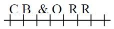 | OO |
Railroad right-of-way  | OO |
Canal or ditch right-of-way  | |
State line  | 4 |
County line  | 4 |
Township and Range line  | 3 |
Section lines  | OO |
Subdivision boundaries  | 3 |
Block boundaries  | 2 |
Lot and parcel lines  | 2 |
City limit lines  | 2 |
Ambiguous description 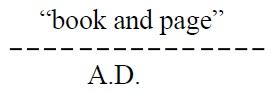 | OO |
Taxing jurisdiction boundary lines  | 3 |
Forest boundaries  | 2 |
Parcel boundaries where needed to clarify the boundary limits  | 3 |
Use for the division of lots  | |
Mining claims  | |
Tie bars  | |
Platted block number  | |
Assigned block numbers  | |
Assigned parcel number  | |
Assigned number for improvement only  | |
Severed mineral rights (interest) should be denoted by putting (S.M.R.) below the parcel number or where space permits  | |
Quarter-section numbering sequence within a section 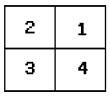 | |
Division of Property Taxation State Assessed  |
Leroy Lettering Guides
It is difficult to establish comprehensive guidelines for all lettering sizes and design. Therefore, good drafting techniques and judgment should prevail on sizes and designs not covered below. If a county uses additional lettering guides, a documentation manual should be developed as a reference for future map maintenance.
| Description | Leroy Guide | Pen Size | |
|---|---|---|---|
| Legal description (lower right-hand corner of map) | 175 (vertical caps.) | 2 | |
| (upper left-hand corner, reading from bottom to top of map) | 100 (vertical caps.) | OO | |
| Sheet number identification (lower right-hand corner of map) | 500 (vertical) | 5 | |
| (upper left-hand corner, reading from bottom to top of map) | 175 (vertical) | 2 | |
| Adjoining sheet descriptions (all 4 edges of map | 175 (vertical upper and lower case) | 1 | |
| Assigned and platted (block numbers) | 140 (vertical) | 1 | |
| Street name | 140 (vertical upper and lower case) | 1 | |
| Subdivision name | 140 (vertical caps.) | 1 | |
| Platted lot number | 100 (vertical) | OO | |
| Assigned parcel number | 100 (vertical) | O | |
| Notation within a quarter section on a Township map, stating that a separate map of that section has been made. | 125 (vertical caps.) | 2 | |
| Notation within a quarter section on a Township map, stating that a separate map of that quarter section has been made. | 120 (vertical caps.) | O | |
| Notation within a quarter section on a section map, stating that a separate map of that quarter-section has been made. | 350 (vertical caps.) | 4 | |
| Notation within a high density area on a quarter-section map, stating that a separate map of that high density area has been made. | 350 (vertical caps.) | 4 | |
| Mining claims name and number | 140 (vertical upper and lower case) | 1 | |
| Water courses, such as rivers, canals, creeks | 100 (slant upper and lower case) | OO | |
| County township code index map | County name | 425 (vertical caps.) | |
| Township code numbers | 200 (vertical) | 3 | |
| Actual township and range numbers | 120 (vertical caps.) | O |
Mapping Drafting Requirements
The use of drafting tape should be kept to a minimum. It should be used only on boundaries that change frequently. Use of borderlines on the maps is optional. Every base film should have a light line just inside the map edge for ease and consistency of trimming the paper prints after reproduction.
Each map should have a north arrow, graphic scale, county index map, township index map, county name, and revision block on the left side of the sheet. There should be a 2" margin on the left side of the sheet for binding and for punching holes in the films for a hanging file.
Each map should be labeled in the lower right-hand corner and the upper left-hand corner with the proper identifying numbers and legal descriptions. In the lower right-hand corner of the map, there should be a notation as to the highest parcel number used within the unplatted areas. The tax area number or identification should be shown on the tax area boundary line. Unsurveyed land should be shown with a dashed line and labeled with the word “unsurveyed.”
The following items shall be shown on the maps:
- Section, township, and range numbers
- Addition or subdivision names
- Legal block numbers
- Lot numbers
- Lot, street, road, and highway dimensions
- Patented mining claims (names and patent numbers)
- Assigned township number
- Assigned block numbers
- Three-digit parcel number
- Ambiguous descriptions shown and noted
- Bearings and exact dimensions of metes and bounds parcels
- City limits
- County lines
- Property ownership lines
- Subdivision and addition boundaries
- Tax area boundaries
- Streets and names
- National and state forest boundaries
- Highway and road rights-of-way
- Highways, roads, numbers designating Federal, State, or local (names and boundaries)
- Railroads and/or right-of-ways
- Creeks, rivers, ditches, lakes, and any other bodies of water (names and boundaries)
- Highest parcel number used
- Notation that a map within a map has been made
- Map number to identify adjoining township, section or quarter-section maps (show on all four edges of map)
- Tie bars for ownership
- Use of public property, whenever known (courthouse, library, school, national park)
The following information is not mandatory for the primary purpose of the maps. However, such information could be valuable to the assessor and other parties, and may be added at some future date at an additional cost:
- Areas of land parcels
- Utility easements and other private rights-of-way
The following mapping source documents should be used in your mapping program:
- United States Geological Survey 7-1/2' and 15' quadrangle maps
- General land office plats and supplements
- Bureau of Land Management plats for oil, gas, and other minerals
- Department of Transportation maps (state and county)
- Aerial photos (if available)
- Subdivision, addition, and town plats
- Legal description of county road rights-of-way
- Legal description of all ditch and canal rights-of-way
- Legal description of all railroad rights-of-way
- List of all county-owned property by legal description
- County block books and land books
- Complete legal description of all parcels of land in the county (deeds)
- Legal descriptions and maps showing the boundary of each taxing entity
- State township four-digit code map, sample provided in packet
Some possible map sources include:
United States Geological Survey
United States Geological Survey Website
Phone: 888-275-8747
United States Department of Interior
Bureau of Land Management
Colorado State Office
2850 Youngfield Street
Lakewood, Colorado 80215
Bureau of Land Management Website
Phone: 303-239–3600
Mapping Drafting Procedures
Preliminary work should be done lightly in pencil on the films, then inked or mocked-up on paper, and then traced onto the film. Permanent data may be put on one side of the film and the data more frequently changed on the other side; or all of the data may be put on one side. The advantage of having permanent data on one side of the film and data more frequently changed on the other side is ease of correction.
The first sheet to be drafted should be a general explanation sheet. This sheet should show the 14-digit parcel numbering sequence, explaining what the numbers represent and how they are tied to a parcel of land.
In addition, a demonstration township map (not to scale) with numbered sections and one section broken into quarter-sections with assigned numbers should be completed. It should have a legend defining the symbology used and should show any other information needed to explain the mapping and parcel numbering system. A sample map (Example Map II) is available on request.
The first map to be drafted should be a map of the respective county showing the state's assigned township numbers, actual township and range numbers, adjoining county names, county seat, and a title. The scale of this map can be adjusted to fit on a 32" × 36" piece of film so it will be compatible with the other maps. A sample map (Example Map I) is available on request.
The next step in the process is the drafting of the township, section, or quarter-section maps as needed. Sample maps (Example Map IV and Example Map V) are available on request. The legal descriptions for each parcel should be extracted from the assessor’s administrative system. This information could be produced by listing schedule numbers from appraisal records by township and range. If the computer system does not have this capability, the hard appraisal records may be used. After the descriptions are extracted, they should be sorted according to township, range, and section numbers. The source documents, listed in Mapping Drafting Requirements, should be utilized to obtain the minimum data required, which is also detailed in the section Mapping Drafting Requirements.
Severed mineral rights should be labeled on the maps by lettering S.M.R. within parentheses. This lettering should be located underneath the parcel number where practical. This lettering means that minerals on this parcel are severed and indicates that a mineral interest file has been set up.
When an owner has acquired parcels that are contiguous, the descriptions may be put on the same computer record; one parcel number may be assigned to the several parcels that are contiguous. However, contiguous parcels may receive a separate parcel number if they are divided by a tax area boundary.
Mapping Discrepancies and Corrections
As the map maker plots the descriptions, any ambiguous descriptions should be researched as soon as they are discovered. The mapper should verify that the legal descriptions were correctly listed and that source documents were not overlooked during the initial research.
If research is necessary, the county clerk’s records, abstract companies, and property owners are reliable sources.
Upon receipt of reliable data, the map maker can correct the maps. When reliable data is unavailable, discrepancies should be marked with a notation indicating ambiguous description (A.D.).
Parcel Number Assignment
After all legal descriptions and all tax area boundaries have been drafted on the maps, a parcel number should be assigned to each parcel within the county. This identifier serves as an ownership and record control number. The parcel number should be used on all assessment records.
Procedures on developing and assigning parcel identification numbers can be found in a later part of this section.
Map Filing
Tax maps are official records of assessment data and are subject to constant use. County and city offices, title and abstract personnel, real estate brokers, surveyors, engineers, and others, are interested in this information. A set of prints should be conveniently accessible to the public.
Base Mylar maps should never be accessible to the public and should be stored in a fireproof cabinet. Base maps should be used only to reproduce additional copies or when updates are required. The base Mylars represent a considerable investment and if damaged, lost, or destroyed, would seriously hamper the work of the assessor. As a safeguard, base maps should be microfiched periodically and stored at an off-site location.
The prints to be used by the public can be stored in a binder for protection. The base maps can be reduced to a more usable size by a professional reproduction company. For the base Mylars, a hanging type file is recommended because it can hold up to 600 originals and any map can easily be pulled from the cabinet without disturbing the other maps. Flat files are not recommended because the ink can wear off double matte Mylar from constant use.
Mapping Maintenance
Once completed, it is essential that the assessment maps and all related assessment records be kept up-to-date. This requires constant vigilance on the part of the assessor. Assessment maps soon become outdated and much of the original value and investment will be lost unless all changes and corrections are made on a regular basis; preferably weekly or at least monthly.
This basic assessment map system is designed for flexibility and growth and requires constant maintenance. The maintenance consists of updating the maps when boundary changes occur. This includes but is not limited to the following:
- Changes in taxing entity boundaries due to an annexation, inclusion, or exclusion
- Creation of a new taxing entity
- Sale of real property improvements only
- Condominium project development
- Severed mineral interests
- Change of tax status of property
- Property splits and mergers
- New highway rights-of-way
Maintenance of the maps involves correction and constant improvement of the maps from new or more accurate survey data, when available.
The source data for maintenance of the maps are:
- Recorded property transfers
- Recorded subdivision filings and plats
- Recorded licensed surveys and other recorded maps
- Highway and road surveys, government surveys, and miscellaneous types of surveys
When a portion of a property is transferred or a merger occurs, a copy of the deed, including the original parcel number(s), should be given to the mapper. The mapper should then update the assessment map and assign new parcel numbers as required.
As subdivision, condominium, and townhome plats are filed, the mapper should plat those developments on layout sheets to standard scales to assure they fit properly with existing property boundaries. Complicated metes and bounds property splits should also be platted on a layout sheet. New parcel numbers should be assigned to the subdivision lots and to the parcel splits. Also, if new highway or other surveys or taxing area boundaries split a property, new parcel numbers should be assigned. The master map should then be revised and new prints run of the updated maps.
NOTE: Documents executed and recorded on or after July 1, 1992, which contain a newly created legal description must include the name and address of the person who created the legal description, § 38-35-106.5, C.R.S. This provision of the law can assist mappers if discrepancies occur.
All recorded documents that cause a change in the assessment maps should be forwarded to the mapper. This flow of information guarantees that accurate information will be reflected on the assessment maps.
The county planning department and/or county commissioners should make an effort to standardize subdivision plat filings to one of the scales recommended for county maps in this section. Use of a standardized scale will enable the mapping department to save time in plotting the subdivisions onto county maps.
Available Typical County Maps
The following example maps are available upon request:
Map I - Example County Township Code Map
Map II - General Mapping Legend and Explanation Sheet
Map III - Example Township Map (scale 1" = 1200')
Map IV - Example Section Map (scale 1" = 200')
Map V - Example Quarter-Section Map (scale 1" = 100')
Computerized Mapping and GIS
Computerized mapping systems are available that will digitize legal descriptions and other cartographic data and display them as points, lines, topographical chains, and polygons. The mapping data is stored in a database and can be easily accessed and edited. Another provision of computer-assisted mapping is automatic error detection and correction parameters. Depending on the mapping tolerance selected, legal descriptions can be plotted and any traverse error corrected or eliminated.
A Geographic Information Systems (GIS) enables the integration of digitized maps with other data having a relationship to location. It is a natural fit for the assessor’s office and allows for information such as sales data, property characteristics, classification, and valuation, to be displayed and analyzed according to its location.
For additional information on computerized mapping and GIS, refer to Addendum 14-A, Guidelines for Assessor Digital Parcel Mapping.
Computer Plotting Software
Plotting software is available for individuals who need to determine shape, area, and accuracy of legal descriptions, without the manual effort involved in plotting a legal description. The software allows the entry of a legal description to obtain a plot on a graphics computer screen or a graphics compatible printer. The plotting software is produced by several companies and should be available at any computer software store.
Specifications for Parcel Numbering
Permanent Parcel Numbering System
An example of a parcel number is shown in Figure 1.
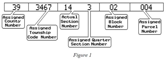
Each parcel of real estate is represented by a 14-digit series of numbers. The first two numbers represent the county. Each of the 64 counties has been assigned a numerical code according to its alphabetical sequence from “01” for Adams County through “63” for Yuma County. (The county number for the City and County of Broomfield is “80.”)
The next four numbers apply to a particular township within the state. Each township in the state of Colorado has been assigned a 4-digit code number. The upper-right-most northeasterly township was assigned number 0001. The townships are numbered in tiers from east to west in the first tier and from west to east in the second tier and so on throughout the entire state. All of the established numbers are odd, 0001, 0003, 0005, etc., continuing through to number 6193 in the southwest corner of the state. The numbering system was established to allow for the insertion of even numbers for errors that may be revealed in the future without destroying the system. A map showing the numbering system is provided in the manila envelope.
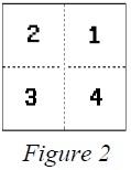
Of the next set of three numbers, the first two represent the actual section number, and the third represents the assigned quarter-section number. The northeasterly quarter-section being numbered “1,” the northwesterly quarter-section being “2,” the southwesterly quarter-section being “3,” and the southeasterly quarter-section being “4.” A set of these three numbers, such as 054, indicates the southeast quarter of section 5. Please refer to Figure 2.
Continuing from left to right in the parcel number, the next two digits are block numbers assigned to platted blocks. Digits “00” always indicate unplatted areas. Where there are platted blocks, each block is assigned a number sequentially regardless of the block number assigned on the subdivision plat.
The last three digits are assigned to a parcel. These numbers are assigned consecutively starting with “001” for each block of subdivided land, and also start with “001” for each parcel of non-subdivided land per map.
The parcel number is tied to the legal description of the total property under a common ownership. The parcel number changes only as a result of a change in the legal description.
Method of Assigning Parcel Numbers
Township Maps
The parcel numbering on a township map begins in the northeast corner of the township in section 1, numbering each parcel in that section using the same pattern as the sections are numbered within a township, starting with the number “001” and continuing consecutively until the last section of the township has been numbered. The pattern used for numbering sections within a township applies. A sample map (Example Map III) is available upon request.
Section Maps
The parcel numbering on a section map uses the same pattern as the sections within a township, beginning with “001” in the northeast corner of the map and continuing until the last parcel at the bottom of the map has been numbered. If there are platted blocks, they should be assigned block numbers starting with “01” using the same pattern previously mentioned. Within each block, the parcel numbering should start over with “001,” beginning in the upper right-hand parcel and continue in a counter-clockwise direction. A sample map (Example Map IV) is available upon request.
Quarter-Section Maps
The parcel numbering on a quarter-section map begins in the northeast corner of the map using the same numbering pattern as the sections within a township. This pattern continues to the bottom of the map. Each block should be assigned a number starting with “01” and should be numbered using the same pattern as mentioned above. The parcel numbering begins with “001” for each block beginning in the upper right-hand corner of the block and continues in a counter-clockwise direction. Within each block, the parcel numbering starts over with “001.” A sample map (Example Map V) is available upon request.
If there are parcels of land within a quarter-section map that are not part of a platted area, they should be numbered using the same numbering pattern as the sections within a township; this numbering begins with “001” and continues to the bottom of the map. Sample maps (Example Map IV and Example Map V) are available upon request.
High Density Maps
High density maps should be used only where absolutely necessary. High density maps should be parcel numbered as if they were a full quarter-section map, using the pattern for numbering as mentioned above for quarter-section maps. Addition and subdivision boundaries should be ignored when parcel numbering.
Contiguous Parcels Under Common Ownership
Contiguous parcels under a common ownership, within the same tax area, may be assigned one parcel number. Tie bars should be used to join these contiguous parcels.
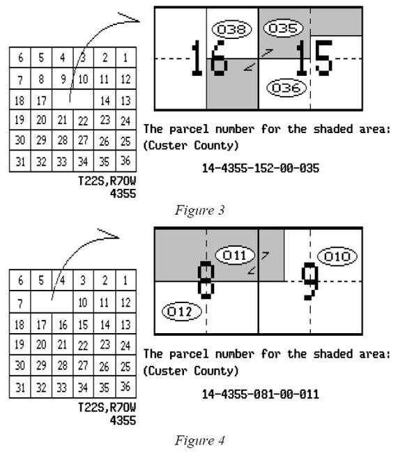
The largest land area should be picked for the assignment of parcel numbers for parcels that overlap from one township into other townships, from one section into other sections, and from one quarter-section into other quarter-sections. The quarter-section designator is assigned based on the quarter section within which the largest land area of the contiguous parcel lies. Refer to Figure 3 for an example.
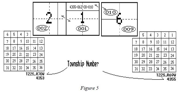
As shown in Figure 4, if the largest land area contains more than one full quarter section, assign the designator to the first quarter section within the counter-clockwise series. This procedure should be followed for each of the recommended map scales.
Parcel Number Creation
Using the information shown in Figure 5, the county is Custer (number 14), the complete parcel number to identify the parcel of land that falls in the northwest quarter of section 6 and the north half of section 1 is written:
14-4355-062-00-010
The number to identify the remainder of section 1 and the east half of the east half of section 2 is written as follows:
14-4353-013-00-001
For the remainder of section 2 the parcel number is:
14-4353-022-00-002
The parcel number to identify the remainder of section 6 is written:
14-4355-061-00-009
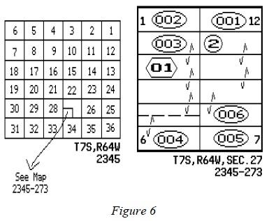
The block in Figure 6 is in Elbert County (number 20), the SW1/4 of section 27, township 7
south, range 64 west of the 6th P.M., the complete parcel number for identification of lots 2-4
and part of 5 is written:
20-2345-273-01-003
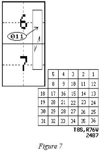
Sections 6 and 7 in Figure 7 are in Park County (number 47), township 8 south, range 76 west of the 6th P.M., the complete parcel number for identification of the parcel that falls in both sections is written as follows:
47-2487-064-00-011
Sections 19 and 24 in Figure 8 are in Kiowa County (number 31), section 19 is in township 18 south, range 45 west; section 24 is in township 18 south, range 46 west of the 6th P.M.; the parcel number for the parcel that falls in both sections (different townships) is written as follows:
31-3871-193-00-002
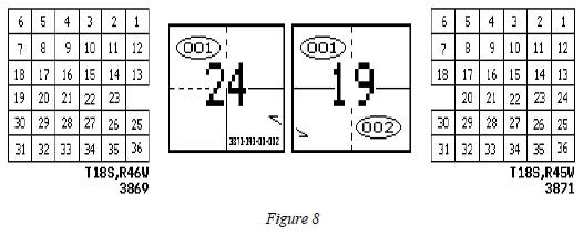
A tie bar should be used to indicate the property in section 24 has the same parcel number as that of section 19. Also, if space is available on the map of section 24, there should be a notation on that part of the parcel that falls on the map of section 19 indicating the complete parcel number.
Parcel Number Deletion
In certain circumstances, parcel numbers must be deleted and new parcel numbers created. Examples include:
- Split of property into two or more separately owned parcels
- Merging or combination of two or more parcels into one parcel
- Splitting of an existing parcel due to creation or change in a taxing entity’s boundary
Property Splits
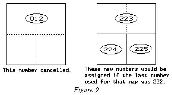
If a property splits, the original number must be canceled and new numbers assigned using the next highest number for that map. Never use the original number again. Please refer to Figure 9.
Property Mergers
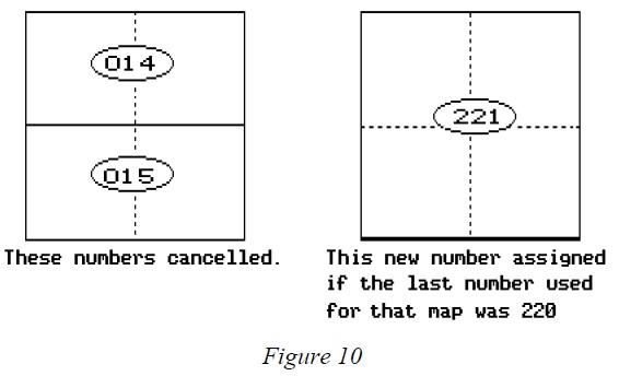
If properties are merged, the original parcel numbers must be canceled and a new number assigned using the next highest number for that map. Please refer to Figure 10.
NOTE: The board of county commissioners is authorized to eliminate interior lot lines or obsolete subdivisions in accordance with the requirements of § 30-28-139, C.R.S. When it does so, the county shall file for recording a notice of merger with the county clerk and recorder, and the notice shall constitute prima facie evidence that the requirements of the statute have been satisfied, § 30-28-139(3)(b), C.R.S. The merged parcels are subject to valuation as a single parcel as of January 1 following the board’s approval of the merger, § 30-28-139(3)(a), C.R.S.
Undivided Interest Numbering
An undivided interest is defined as an interest in property that cannot physically be identified as being distinct and separate from the interests of the other owners. The owner of an undivided interest owns an interest in the entire property, but no separate physical part can be identified as belonging to the owner exclusively.
One parcel identification number should be assigned to a parcel, except for severed mineral interests, regardless of the number of undivided interest holders.
NOTE: If improvements are located on the parcel, care should be taken to determine the ownership of the structures. Generally, the improvements carry the same ownership as the land. However, it is possible for one undivided interest holder to own 100% of an improvement. If the latter applies, a separate parcel identification number should be assigned to the improvement. Refer to Line Weights and Symbols in this chapter.
Property Split by Taxing Entity Boundaries
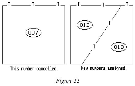
Any property that is split when a new taxing entity is created, or by a change in an existing taxing entity’s boundary, may have a new parcel number assigned to each portion of the parcel. The old parcel number may be deleted and a new number assigned using the next highest number for that map. Please refer to Figure 11.
Condominium Numbering
Each condominium unit is assigned a separate parcel number. An arbitrary block number should be assigned to each building or group of units within each condominium filing. Please refer to Figure 12.
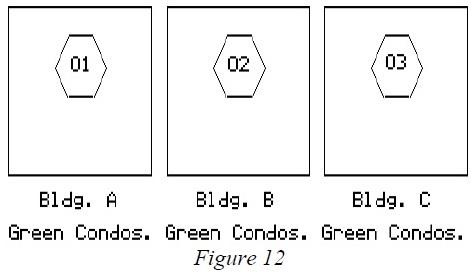
In Figure 12 there is one condominium filing, Greens Condominiums, containing three buildings (Building A, B, and C). Each building is assigned an arbitrary block number as shown. In the example, block number 01 is assigned to Greens Condominium building A, block number 02 is assigned to building B, and block number 03 is assigned for building C. Block numbers should be determined according to the parcel numbering sequence for that section or quarter section map. Parcel numbers should be assigned, beginning with parcel number 001, to each condominium unit. The first and last parcel number used per building should also be shown, Figure 13.
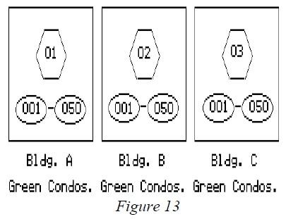
In Figure 13, each building contains 50 condominium units. Each of the 150 units is assigned a separate parcel number. In the example, Building A, Units 100 through 150 are assigned block 01, parcel numbers 001 through 050. Building B, Units 200 through 250 Building B are assigned block 02, parcel numbers 001 through 050. Building C, Units 300 through 350 are assigned block 03, parcel numbers 001 through 050. The distinction between units is made by assigning different block numbers.
Parcels designated as common areas by the condominium plat should be shown and numbered on the assessment map. Parcel numbers for a common area should have the notation C.A. after parcel number. If improvements exist on common area land, they may be assigned a parcel number with the assigned three-digit parcel number noted within a square.
To allow for changes in parcel numbers due to replatting or ownership changes, buildings containing more than 600 units should be assigned a new block number for each group of 600 units. Refer to Figure 14.
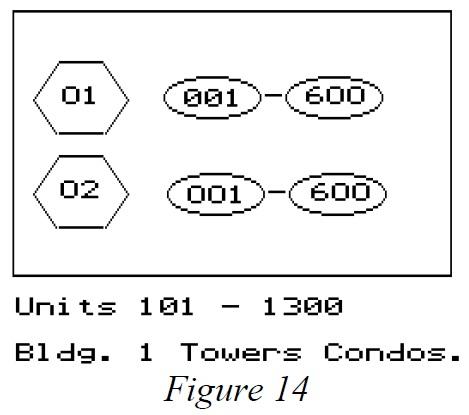
Figure 14 shows a single condominium filing with a single large condominium building containing 1200 condominium units. The first 600 units are assigned block number 01, parcel numbers 001 thru 600. The next 600 units are assigned block number 02, parcel numbers 001 thru 600.
Condominium ownership is the only situation where block numbers are assigned to a group of units rather than to actual property blocks.
Miscellaneous Items for Parcel Numbering
The various types of identification of other items covering highways, streets, utility rights-of-way, utility property assessed by the Division of Property Taxation, and exempt properties, are as follows:
- Easements, ditches, rivers, and streams are not assigned parcel numbers.
- Highways, streets, and roads should not receive a parcel number if dedicated and accepted by the city or county. If they have not been dedicated and/or accepted, the parcel should receive a parcel number in the same manner as any other land parcel.
- Rights-of-way considered as part of a public utility’s operating property are not assigned parcel numbers, but are shown with the notation “D.P.T.” (which stands for Division of Property Taxation assessed). Utility rights-of-way which are not utility operating property must receive a parcel number as any other land parcel. If necessary, contact the Division of Property Taxation, State Assessed Section to determine whether the right-of-way is an operating property.
- All other operating state assessed properties are assigned a parcel number and noted with the wording “D.P.T.”
- Exempt properties are assigned a parcel number and noted “Exempt.” For exempt properties, the last three digits of the parcel number may begin with 900 and continue forward.
- Patented mining claims should be assigned numbers in the same manner as other land parcels.
- Unpatented mining claims are exempt from taxation and should receive an “Exempt” parcel number as stated in bullet point 5 above.
When rivers, streams, or other bodies of water split a property into segments, a separate parcel number should be assigned for each segment providing the body of water is so described in the deed. When roads, highways, ditches, or streets split a property into segments, a separate parcel number should be assigned for each segment providing the road, highway, ditch, or street is accepted by dedication or the exclusion of these items are so noted by deeds.
Properties that are contiguous under a common ownership but are split by a county line or taxing jurisdiction boundary will require a separate parcel number for each segment that is severed from the whole. Before starting the parcel numbering, a work map should be made showing the taxing jurisdiction boundaries.
If an owner of a parcel of land adjoining a vacated street or alley has not received the title to the vacated land, then such land is assigned a parcel number. If the property reverts to the adjoining owner, it can be joined by a tie bar. The old number is canceled and a new number assigned to the two parcels of land that have been merged together as one parcel.
Exceptions to Parcel Numbering Specifications
Section 39-5-103.5, C.R.S., requires that all assessors maintain full, accurate, and complete maps showing the parcels of land in the county. Also contained within this statute is the requirement that the Division of Property Taxation establish guidelines for mapping uniformity throughout the state.
A written request to the Division of Property Taxation for approval to incorporate any special situations into the county mapping program not covered by these mapping and parcel numbering specifications is mandatory.
Summary
A good mapping system is the foundation for a good parcel identification system. The mapping system can be based on ground surveys or could incorporate computers, electronic map plotters, and satellite photography.
Colorado statutes require that all counties prepare and maintain a mapping system. These guidelines have been prepared by the Property Tax Administrator to aid the assessors in accomplishing this task.
To determine proper mapping costs, items such as county size, parcel count, accuracy of records, and availability of existing state and federal maps should be considered. Information on costs and potential problems can be obtained by contacting adjacent counties that have ongoing mapping programs.
A part of the mapping process is the assignment of parcel identification numbers. Each number is based on the legal description of the parcel and ownership status. With a parcel number, each property can be uniquely identified.
Written approval from the Division of Property Taxation must be obtained to incorporate any changes or special situations not covered in these guidelines.
Addendum 14-A, Guidelines for Assessor Digital Parcel Mapping
Introduction
The Guidelines for Assessor Digital Parcel Mapping were developed to provide uniformity in the creation and maintenance of graphic and tabular data. It is hoped this structure will benefit agencies that participate in data sharing. In the creation of the Guidelines for Assessor Digital Parcel Mapping for the state of Colorado, it is important to first look at the current requirements for assessment maps. The Property Tax Administrator is required by law to establish uniform guidelines for parcel mapping. The Division of Property Taxation, Department of Local Affairs, authored and published the ARL Volume 2, ADMINISTRATIVE AND ASSESSMENT PROCEDURES MANUAL, Chapter 14, Assessment Mapping and Parcel Identification. This document guides each county's parcel mapping effort so that across the state there is some uniformity in the maps. In addition, we have included an introductory section on the metadata standards developed by the Federal Geographic Data Committee. Metadata describes the content, quality, condition, and other characteristics of data.
There are some assumptions made in this document. It is assumed that the graphic data is stored in the North American Datum of 1983 (NAD83) values, and if possible, in the Colorado adjustment of that datum (NAD83/92). Since the parcel maps are reflective of data created by land surveyors, the unit of measurement is the U.S. Survey foot. The Federal Government has made the move to the meter as the Official Unit of Measurement, but inherent in most of the Geographic Information Systems (GIS) is the capability to transform data from one unit of measure to another, as well as from one mapping projection to another. Ideally, each county’s GIS will store its data in state plane coordinates in U.S. Survey feet, as defined in §§ 38-52-101 through 106, C.R.S.
Using ARL Volume 2, ADMINISTRATIVE AND ASSESSMENT PROCEDURES, Chapter 14, Assessment Mapping and Parcel Identification, as a guide, data can be broken down into four basic data types: lines, polygons, points, and text. Data concerning these four basic data types are detailed within this document. This document also covers survey control as an important area to be addressed.
Lines, polygons, points, and text can be generally stratified by one of five basic themes. Line requirements for assessor’s maps are detailed in ARL Volume 2, ADMINISTRATIVE AND ASSESSMENT PROCEDURES, Chapter 14, Assessment Mapping and Parcel Identification.
- Boundary data
- State boundaries
- County boundaries
- City and town boundaries
- Forest boundaries
- Taxing jurisdiction boundaries
- Hydrographic data
- Natural flowing water (rivers, creeks and streams)
- Stationary water (lakes and reservoirs)
- Man-made flowing water (canals and ditches)
- Landnet data
- Geodetic control
- Public Land Survey System (PLSS)
- Township, range, and section lines
- Parcel data
- Parcels
- Block boundaries
- Lot boundaries
- Subdivision boundaries
- Road rights-of-way (ROW) and road easements
- Ditch rights-of-way
- Canal rights-of-way
- Utility easements
- Mining claims
- Ambiguous legal descriptions
- Parcels
- Transportation data
- Physical roads (road centerlines and edges)
- Airports
- Railroads
NOTE: The above is not intended to be all-inclusive.
In the migration to a GIS, there are three additional line types that can be added to aid in connectivity and topology:
- Common ownership lines (rather than tie bars)
- Utility easement lines
- Right-of-way lines that are for graphic purposes only
These lines represent an apparent ROW when there is no deed to support it.
A linking feature, such as a centroid, can be added as a data management tool.
A number of factors influence the organization of themes in a geographic database, and they differ with each application. The attributes of the above list may be established as individual layers or combined and established as one layer. The key to establishing layers is to determine the data needs and how an agency will use the GIS. Attributes may be organized thematically by what they represent. For example, even though sewer piping and power lines are both linear features, their descriptive attributes may be quite different. The attributes associated with a sewer pipe may include its diameter, piping material, flow direction, date of installation, etc.; while attributes for power lines consist of wiring size and material, voltage, and other electrical data. Because their associate attributes differ significantly, the sewer lines and power lines should be stored as separate themes. Keep in mind, that once data is combined and established as a layer, it cannot be separated without significant manual manipulation. When attributes are established as individual layers, they can be combined as needed for each project; thus, the data is easier to manipulate. This can be a distinct advantage when processing specific requests or creating “custom” projects.
Attributes
An attribute is data about a map feature that is typically stored in a database format as a record. Four common types of attributes are detailed below. These include line, polygon, point, and text attributes.
Common Line Attributes
The GIS can store information about each line segment as attributes to each line segment. These attributes describe and define line segments. Graphic or tabular data can be created by querying the data sets. The line weights are defined in ARL Volume 2, ADMINISTRATIVE AND ASSESSMENT PROCEDURES, Chapter 14, Assessment Mapping and Parcel Identification. Color attribute standards should be developed and documented by each county. The following commonly used attributes for line features, although not a comprehensive list, are recommended.
- A unique identification number
- An attribute for the angle or bearing of the line segment
- An attribute for the distance of the line segment
- Attributes for storing curve information
- Radius
- Delta
- Tangent
- Arc length
- Which side of the line segment the curve is on
- An attribute for drawing the line segment in its proper symbology
- An attribute for the source of the line
- 5 = Global Positioning System (GPS)
- 4 = Coordinate geometry (COGO)
- 3 = Digitizing
- 2 = Scanning
- 1 = Other
- An attribute for the confidence of the positional accuracy of the line
- 5 = Highest confidence - 1 = Lowest confidence
- An attribute for the date when the line was created in the GIS
- An attribute for the date when the line was changed in the GIS
- An attribute for comments
Additional attributes, such as information as to who created the line segment, may be added for data management purposes.
Common Polygon Attributes
When the polygons are created in the GIS, a link between the graphic data and the associated tabular data must be established. This is accomplished by placing a feature, such as a centroid, within the polygon that contains attributes that can be linked to various tabular data bases. The attribute that links the individual polygon to its tabular data is a unique identification number, such as the 14-digit state parcel identification number or the schedule number. Information concerning the 14-digit state parcel identification number is located in ARL Volume 2, ADMINISTRATIVE AND ASSESSMENT PROCEDURES, Chapter 14, Assessment Mapping and Parcel Identification.
In addition to the unique identification number, other important polygon attributes include:
- An X-Coordinate for the linking feature
- A Y-Coordinate for the linking feature
- The 14-digit state parcel identification number
- The area of the lot/parcel
The areas generated in the GIS are based upon a mapping projection, and some manipulation must be done to generate ground or platted areas in the GIS. If the platted or deeded areas are known, it would be easier to store them as attributes for inquiry purposes. The area could also be stored in acres as an additional attribute. - A confidence factor for the area
5 = Highest Confidence - 1 = Lowest Confidence
The confidence on the “area” attribute should be determined based upon the source. For example, an area that came from a Subdivision plat or a deed would have a higher confidence than an area that came from a planimeter or was generated from the system. - An attribute for storing the layer information
- An attribute for the date when the polygon was created in the GIS
- An attribute for the date when the polygon was changed in the GIS
- An attribute for comments
As with the line features, data management attributes such as who created the polygon may be added.
Common Point Attributes
There are several cases where data will be stored as points rather than lines or polygons. These points have the following common attributes.
- A unique identification number
- An attribute for the state plane northing of the point feature
- An attribute for the state plane easting of the point feature
- An attribute for drawing the point feature in its proper symbology
- An attribute for the source of the point feature
- 5 = Global Positioning System (GPS)
- 4 = Coordinate geometry (COGO)
- 3 = Digitizing
- 2 = Scanning
- 1 = Other
- An attribute for the confidence of the point feature
- 5 = Highest Confidence - 1 = Lowest Confidence
- An attribute for the date when the point was created in the GIS
- An attribute for the date when the point was changed in the GIS
- An attribute for comments
Common Text Attributes
The Property Tax Administrator has published standards for map text in ARL Volume 2, ADMINISTRATIVE AND ASSESSMENT PROCEDURES, Chapter 14, Assessment Mapping and Parcel Identification. The text attributes that may be associated with each text feature include:
- A unique identification number
- Information about the text string
- The text string itself
- The size of the text
- The symbol it is drawn as
- An attribute for the date the text was created in the GIS
- An attribute for the date the text was changed in the GIS
- An attribute for comments
Data management attributes may be added to the text strings. However, unlike the attributes to line segments and polygons, there is very little intelligence to the attributes of text features.
Survey Control
Geodetic control and its ties to the section, township and range grids are critical to a GIS. For this reason, the attributes for the geodetic control layer and the Public Land Survey System have been identified so that the overall quality can be gauged. Geodetic control is the foundation of all digital mapping, and compliance with the National Mapping Accuracy Standards is a goal that can be achieved beginning with good ground control and good mapping techniques.
Typically, a landnet is generated from the U.S.G.S., 7.5 minute quadrangle. This data may be accurate to +/- 40 feet spatially, or it could be as much as a few hundred feet in error. While this is adequate enough to create a “picture” of what exists, it will not be to the level of accuracy required for all potential GIS data users. It is important for an entity to assess its accuracy requirements based on current and future GIS/mapping applications. While it may be less expensive to build a GIS dataset that has low absolute accuracy, this decision may limit the types of applications that can be deployed. For many assessor applications, other measures of accuracy, such as attribute accuracy and relative accuracy, may be as important as absolute accuracy.
The Colorado Department of Transportation created a statewide geodetic control network called the High Accuracy Reference Network (HARN). There are many projects underway across Colorado to densify the HARN in order to make it more useful locally. Counties may work with the state to densify the HARN within their boundaries. This will greatly improve the accuracy of the GIS graphic data. From this network the local land surveyors can generate information on section corners, including coordinates.
The attributes for these layers are as follows.
Common Geodetic Control Layer
- A unique identification number
- An attribute for drawing the monument at its proper symbology
- An attribute for the monument name
- An attribute for the agency who set the monument
- An attribute for the horizontal accuracy of the monument
- An attribute for the vertical accuracy of the monument
- An attribute for the latitude of the control monument
- An attribute for the longitude of the control monument
- An attribute for the ellipsoidal height of the control monument
- An attribute for the state plane northing of the control monument
- An attribute for the state plane easting of the control monument
- An attribute for the state plane zone of the control monument
- An attribute for the geoidal height of the control monument
- An attribute for the orthometric height of the control monument
- An attribute for the horizontal datum
- An attribute for the vertical datum
- An attribute for the section in which the control monument is located
- An attribute for the township in which the control monument is located
- An attribute for the range in which the control monument is located
- An attribute for the name of the U.S.G.S., 7.5 Minute Quad in which the monument is located
- An attribute for the date in which the monument was entered into the GIS
- An attribute for the date when the monument was last recovered in the field
- An attribute for the physical description of the monument
- An attribute for comments
Common Public Land Survey System Layer
- A unique identification number
- An attribute for the aliquot description of the monument
- An attribute for the section in which the monument is located
- An attribute for the township in which the monument is located
- An attribute for the range in which the monument is located
- An attribute for the principal meridian
- An attribute for the name of the U.S.G.S., 7.5 Minute Quadrangle in which the monument is located
- An attribute for the state plane northing of the monument
- An attribute for the state plane easting of the monument
- An attribute for the state plane coordinate zone of the monument
- An attribute for the horizontal datum of the monument
- An attribute for the confidence of the coordinate value of the monument
- 5 = Highest Confidence - 1 = Lowest Confidence
- An attribute for the source of the coordinates
- 5 = Global Positioning System (GPS)
- 4 = Coordinate geometry (COGO)
- 3 = Digitized
- 2 = Scanned
- 1 = Other
- An attribute for the master index number of the monument
- An attribute for the date when the monument was entered into the GIS
- An attribute for the date when the monument was last recovered in the field
- An attribute for the physical description of the monument
- An attribute for comments
Digital Data Management
GIS data organization and management is essential. To better manage the GIS data created from the parcel maps, parcel directory and layer naming conventions should be established.
An example of parcel directory and layer naming conventions is shown below. These are in compliance with the International Organization for Standards (ISO) standard concerning the 8.3 file naming conventions. The layers should be broken down by township, using the unique four-digit township numbering system as identified by the Division of Property Taxation in ARL Volume 2, ADMINISTRATIVE AND ASSESSMENT PROCEDURES, Chapter 14, Assessment Mapping and Parcel Identification. Each parcel layer should be broken down by sections, so there will be a maximum of 36 section layers in each township directory. The layers can also be stored as full or partial townships under the township directory if there is not enough parcel data to break it out to a section level.
The following outlines this structure for township 1234:
Directory: twp1234
Layers:
- s01_1234
- s02_1234
- s03_1234
- s04_1234
- s05_1234
- s06_1234
- s07_1234
- s08_1234
- s09_1234
- s10_1234
- s11_1234
- s12_1234
- s13_1234
- s14_1234
- s15_1234
- s16_1234
- s17_1234
- s18_1234
- s19_1234
- s20_1234
- s21_1234
- s22_1234
- s23_1234
- s24_1234
- s25_1234
- s26_1234
- s27_1234
- s28_1234
- s29_1234
- s30_1234
- s31_1234
- s32_1234
- s33_1234
- s34_1234
- s35_1234
- s36_1234
The following example shows how full and partial township layers would be named, again using township 1234:
Directory: twp1234
Layers:
- full_1234 - Full township layer
- part_1234 - Partial township layer
This is where one or more sections are broken out, and the naming convention outlined above is used, with a portion of a township remaining.
- n2_1234 - North half of a township layer
- s2_1234 - South half of a township layer
- e2_1234 - East half of a township layer
- w2_1234 - West half of a township layer
- nw4_1234 - Northwest quarter of a township
- sw4_1234 - Southwest quarter of a township
- se4_1234 - Southeast quarter of a township
- ne4_1234 - Northeast quarter of a township
The township layers should only be broken down to the quarter township level. If the data or source is less than a quarter township, it should be broken down into sections using the naming convention appropriate for the section layers.
Metadata Standards
Metadata or "data about data" describe the content, quality, condition, and other characteristics of data. Metadata are used to organize and maintain investments in data, to provide information to data catalogs and clearinghouses, and to aid data transfers. The Federal Geographic Data Committee (FGDC) approved the Content Standard for Digital Geospatial Metadata on June 8, 1994. Since that time, many organizations within and outside of the federal government have adopted the FGDC metadata standard and are using automated indexing and serving mechanisms to provide access to their holdings through the Internet. In addition, the GIS software vendor community has been very active in both the definition and adoption of the standards.
The objectives of the standard are to provide a common set of terminology and definitions for the documentation of digital geospatial data. The standard establishes the names of data elements and compound elements (groups of data elements) to be used for these purposes, the definitions of these compound elements and data elements, and information about the values that are to be provided for the data elements.
The standard was developed from the perspective of defining the information required by a prospective user to determine the availability of a set of geospatial data, to determine the fitness of the set of geospatial data for an intended use, to determine the means of accessing the set of geospatial data, and to successfully transfer the set of geospatial data. As such, the standard establishes the names of data elements and compound elements to be used for these purposes, the definitions of these data elements and compound elements, and information about the values that are to be provided for the data elements. The standard does not specify the means by which this information is organized in a computer system or in a data transfer, nor the means by which this information is transmitted, communicated, or presented to the user.
In addition to use by the federal government, the FGDC invites and encourages organizations and persons from state, local, and tribal governments, the private sector, and non-profit organizations to use the standard to document their geospatial data. Although there are no current requirements for adoption of the standards at the state and local level, the adoption of metadata standards can be very beneficial in that metadata helps a municipality to document and maintain GIS data and facilitates the transfer of digital geographic information between entities, e.g., city-to-county data sharing.
For more information regarding the metadata standards, the Federal Geographic Data Committee maintains a web page. From this site, a current copy of the Content Standard for Digital Geospatial Metadata can be downloaded. The FGDC can be contacted at:
Federal Geographic Data Committee Secretariat
12201 Sunrise Valley Drive MS 590 Reston, VA 20192
Federal Geographic Data Committee Secretariat Website
Email: fgdc@fgdc.gov
Phone: 703-648-5755