Assessor’s Duties
The county assessors are responsible for the management and operation of the assessor’s office. Their goal is to produce the tax warrant with fair and equalized property values. The county assessor’s office must be located at the county courthouse or at a location in the county seat provided by the board of county commissioners. The assessor may keep one or more offices outside of the county seat, in addition to the office located in the county seat. The additional location may be kept only if the board of county commissioners makes office space or funding available, § 30-10-803, C.R.S.
A complete list of all Colorado county assessors is shown in Addendum 1-A, List of Assessors. More information on the Colorado Assessors’ Association (CAA) such as officers and assessors’ districts can be found on the CAA website at Colorado Assessors' Association.
Discover – List – Classify – Value
The major duties of an assessor can be categorized as discovering, listing, classifying, and valuing all taxable real and personal property and all property granted exemption by the Division of Property Taxation that is located within the county on the assessment date. These categories are often referred to as the assessment function, § 39-5-101, C.R.S.
Some property in the county such as state assessed properties are valued and apportioned to each county by the Division of Property Taxation (Division), article 4 of title 39, C.R.S. Refer to Chapter 11, State Assessed Property for more details. Other property is classified by the assessor or by the Division as exempt, article 3 of title 39, C.R.S. Please see Chapter 10, Exemptions for more information regarding this class of property.
The discovery of property is accomplished by examining the records of the county clerk and recorder; physically reviewing all property; examining building permits; and reviewing those listings of business firms contained in telephone books, business journals, and other documents.
The listing phase of the assessment function includes describing and identifying the physical location of property. Listing also includes the maintenance and updating of records linking properties to respective owners so that a current assessment file is created.
Classification consists of determining the correct class for all property located in the county according to its use on the assessment date. The proper classification will have a bearing on both the method used to value the property and the assessment rate applied. Classification is also important when properties are compared in both the appeals and the valuation processes. Refer to Chapter 6, Property Classification Guidelines and Assessment Percentages for detailed information on property classes. Division of Real Estate at 303-894-2166 prior to the meeting to confirm the meeting date and location.
Property is valued by the assessor following valuation criteria as stipulated by statute and by using manuals, appraisal procedures, and instructions issued by the Property Tax Administrator (Administrator). The valuation phase of the assessment function includes notifying the taxpayer of the value and the administrative remedies that must be followed if the taxpayer disagrees with the assessor’s valuation.
Certification of Appraisers
All county real property appraisal staff are required to be Colorado licensed or certified appraisers, § 12-10-606(4)(A), C.R.S. The requirements, examination, and licensing are under the administration and supervision of the Colorado Board of Real Estate Appraisers (Board).
Additionally, the Board is empowered to determine whether an applicant for licensure or certification possesses the necessary qualifications for licensure or certification required. The Board may consider such qualities as the applicant’s fitness and prior professional licensure and whether the applicant has been convicted of a crime, § 12-61-712(1), C.R.S.
Appraisal staff members have two years from the date of hire to become licensed or certified. For more information, refer to Addendum 1-B, Certification of Real Estate Appraisers.
Taxpayers’ Remedies
Notices of value and protest forms are mailed to property owners annually, § 20, art. X, COLO. CONST. and § 39-5-121, C.R.S. A taxpayer may also request a notice of valuation by electronic transmission, § 39-5-121, C.R.S. Assessors review real and personal property protests during the months of May and June. The assessor must respond to the property owner’s protest in writing. Refer to Chapter 5, Taxpayer Administrative Remedies, for more information on taxpayers’ remedies.
Abstract of Assessment
The assessor prepares an Abstract of Assessment report (a summary of assessed value by class and subclass of property) which is for official use by the State Board of Equalization and the Division, § 39-5-123, C.R.S.
The assessor files the Abstract of Assessment (abstract) with the Property Tax Administrator no later than August 25. If the county is required to, or has chosen to follow the alternate protest period procedures, the final Abstract of Assessment is due no later than November 21. For those counties following the alternate protest period, the Division requests that the county file a preliminary abstract no later than August 25.
The abstract serves many other purposes. It contains the aggregate assessed valuation for assessment of all property by class and subclass. The data is the basis for the certification of values to the various taxing entities. The abstract data collected from each county is included in the Annual Report to the Governor and the General Assembly.
Other groups including the General Assembly and the general public use the information for a variety of purposes. The abstract values, with changes, serve as the basis of the next year’s tax warrant. Additional information on the abstract can be found in Chapter 7, Abstract, Certification, and Tax Warrant.
Certification of Value
On August 25, the assessor certifies total values to the Department of Education and the various taxing entities within the county, § 39-5-128, C.R.S. The entities use the data to calculate their property tax rates (mill levies), calculate revenue and spending limitations, and decide whether or not they must ask the electorate for additional funds. If valuation changes occur after certification, the assessor must notify the entities of these changes prior to January 3, for 2024 only, § 39-1-111(5), C.R.S. Changes between the abstract and tax warrant should be documented so that the assessor can justify those changes, if requested to do so. For more information see Chapter 7, Abstract, Certification, and Tax Warrant.
Tax Warrant
January marks the end of one assessment year and the beginning of another. On January 24, for 2024 only, the assessor delivers the prior year’s tax warrant to the treasurer for collection. The warrant lists all property owners’ names, property legal descriptions, assessed valuation attributable to land, improvements, and personal property, and the taxes due, § 39-5-129, C.R.S. The treasurer is then responsible for collection of all taxes listed on the warrant, § 39-5-129, C.R.S. For additional information on the tax warrant, refer to Chapter 7, Abstract, Certification, and Tax Warrant.
Public Records
The statutes declare that all public records shall be open for inspection by any person at reasonable times, except as otherwise provided by law, § 24-72-201, C.R.S. The assessor may implement inspection rules which protect the records and prevent unnecessary interference with the regular discharge of the duties of the assessor’s office, § 24-72-203, C.R.S.
Public records include all writings kept by the state or political subdivision (county) for use in performing functions that are required by law or administrative rule § 24-72-202(6), C.R.S. Writings include all books, papers, maps, photographs, cards, tapes, recordings, or other documentation, regardless of physical form or characteristics, but does not include computer software, § 24-72-202(7), C.R.S.
If records are in active use or in storage, and therefore, not available for inspection, the assessor shall notify the applicant in writing if requested. If requested by the applicant, the assessor shall set a date and hour within three working days at which time the records will be available.
If the request involves a large volume of records and the assessor is unable to provide them within three working days due to extenuating circumstances, the assessor will provide the records within seven working days, § 24-72-203(3), C.R.S. Records may be provided in a digital, searchable or sortable format if the custodian of the record has the ability to do so, § 24-72-203(3.5)(a), C.R.S.
At the written request of any taxpayer or taxpayer’s agent, the assessor must make available the data used in determining the actual value of any property owned by the taxpayer within seven (7) working days following the written request. Upon receiving the request, the assessor must immediately advise the taxpayer or agent of the estimated cost of providing the data. The intent of the statute is that the assessor immediately estimates the cost because payment must be sent to the assessor prior to providing the data. Once the data is gathered, the assessor can choose whether the data is mailed, faxed, or sent by electronic transmission to the taxpayer or agent. If the estimated cost was lower than actual costs, the assessor may include a bill with the data for any reasonable cost above the estimated cost subject to the statutory maximum.
The additional costs are due and payable upon receipt of the data, § 39-5-121.5, C.R.S. No transmission fees may be charged for the transmission of public records via electronic mail, § 24-72-205(1)(b), C.R.S.
The assessor may impose a fee when responding to a request for the research and retrieval of public records if they have a written policy in place regarding charges. The policy must have been published or made available on the custodian’s website prior to receiving the request for information.
The assessor is not allowed to charge for the first hour of time expended in connection with the research and retrieval of public records. However, after the first hour, the custodian may charge a fee for the research and retrieval of public records. The fee may not exceed thirty three dollars and fifty-eight cents per hour. This hourly rate will remain in effect until July 1, 2024, when the Director of Research of the Legislative Council adjusts the maximum hourly fee. This adjustment will occur every five years in accordance with the percentage change over the period in the United States Department of Labor, Bureau of Labor Statistics, Consumer Price Index for Denver-Aurora-Lakewood, all items, all urban consumers, or its successor index, § 24-72-205(6), C.R.S.
The amendment to § 39-5-121.5, C.R.S., in HB 00-1268, provides a mechanism for taxpayers to acquire the data used to calculate the value of their properties outside the public records statutes. In essence, it gives assessors seven (7) working days to prepare the data and send it to the taxpayer or agent instead of the three working days if records are not readily available, or seven (7) working days under extenuating circumstances provided in § 24-72-203, C.R.S. The amendment should be read in concert with article 72 of title 24, C.R.S.
NOTE: The public records statutes presently provide that all public records must be open for inspection by anyone at reasonable times; that officials should take measures to assist the public in locating any public record; and that officials must ensure public access to the public documents. If the records are not readily available at the time of the request, the custodian must notify the applicant of this fact. If the applicant requests an appointment, the custodian must set a date and hour for the inspection to take place. The reasonable time stated in the statute is within three working days unless extenuating circumstances exist as outlined in the statute. If extenuating circumstances exist, the inspection must occur within seven working days, §§ 24-72-203(1) and (3), C.R.S.
Records Request of Public Officials
Public records are writings which are made, maintained or kept by the state, an agency, or political subdivision of the state for use in the performance of public functions or that they are involved in the receipt and spending of public money. When the custodian of requested public record under the Colorado Open Records Act (CORA) is an individual who is also a public official, the plaintiff bears the burden of proving that the requested records are likely public records, Denver Post Corp. v. Ritter, 255 P.3d 1083 (Colo. 2011).
Acceptance & Distribution of Electronic Records by Governmental Agencies
Each governmental agency may determine the extent to which it shall send and accept electronic records and electronic signatures and otherwise create, generate, communicate, process, store, use and rely upon electronic records and signatures, § 24-71.3-118, C.R.S. It is important to note that statute does not require a governmental agency to use electronic records or electronic signatures, § 24-71.3-118(3), C.R.S.
Legal Recognition of Electronic Records, Signatures and Contracts
A record or signature may not be denied legal effect or enforceability solely because it is in an electronic form. If the law requires a record to be in writing, an electronic record satisfies by law, § 24-71.3-107, C.R.S.
House Bill 15-1117 clarified the application of the “Uniform Electronic Transactions Act” with the addition of two definitions to § 7-90-102, C.R.S.
“Writing” or “written,” unless otherwise provided in the constituent document, includes an “electronic record” as that term is defined in the “Uniform Electronic Transactions Act,” § 24-71.3-102(7), C.R.S.
“Signature” or signed,” unless otherwise provided in the constituent document, includes an “electronic signature” as that term is defined in the “Uniform Electronic Transactions Act,” § 24-71.3-102(8), C.R.S.
Confidential Information
Unless otherwise provided by law, the assessor shall deny inspection of records containing the following information: trade secrets; privileged information; and confidential commercial, financial, geological, or geophysical data, furnished by or obtained from any person. The assessor shall also deny inspection of social security numbers unless the disclosure of such a number is required, permitted, or authorized by state or federal law, §§ 8-2-128(2), 24-72-204(3)(a)(IV), 39-1-104(16)(c), 39-5-115(2) and 120, 39-7-101(4), and 39-14-102(1)(c), C.R.S.
The individual Real Property Transfer Declaration forms are subject to confidentiality requirements as provided by law. The declarations may be inspected by the grantee specified in the document, the grantor (if the grantor filed the document), the persons conducting any valuation for assessment study or their employees, and the Property Tax Administrator and Division employees, § 39-14-102(1)(c), C.R.S. Although the use of the information derived from the forms to assist the assessor in the valuation of property is allowed, it must be presented in such a manner that the source cannot be identified, § 39-5-121.5, C.R.S.
Manufactured Home Transfer Declaration forms are subject to confidentiality requirements as provided by law. The declarations may be inspected by the county assessor and his or her employees, the taxpayer specified in the manufactured home title application or the person that filed the declaration, and the Property Tax Administrator and Division employees, § 39-14-103(1)(c), C.R.S. The county assessor will review information derived from the declarations to properly adjust sales for sales ratio analysis for determining the value of titled manufactured homes, § 39-14-103(3), C.R.S.
Confidential information also includes detailed listings of personal property reported by a prior owner, whether or not values are included with the listing. Pursuant to § 39-5-120, C.R.S., the Personal Property Declaration Schedule and attachments are confidential documents and only the following persons have a legal right to view them:
- The county assessor or members of the assessor’s staff
- The county treasurer or members of the treasurer’s staff
- The annual assessment study contractor, hired pursuant to § 39-1-104(16), C.R.S., and employees of the contractor
- The executive director of the Colorado Department of Revenue and staff members of the Department of Revenue
- The Property Tax Administrator and Division of Property Taxation staff
- The county board of equalization (CBOE) and the Board of Assessment Appeals (BAA) when pertinent to a hearing or protest review
- The person whose property is listed on the schedule
- Personal property records ordered opened by the district court
Anyone listed above who uses the personal property schedules as part of official duties is also subject to the confidentiality provisions and may be held accountable for divulging the information on the schedule. The statutory penalties for divulging confidential information include a fine of not less than $100 nor more than $500, or a prison term of up to three months, or both as provided for in § 39-1-116, C.R.S.
Section 7602 of title 26 of the United States Code allows representatives from the Internal Revenue Service (IRS), the federal authority, to examine and/or summon certain information (including confidential declaration schedule information) that the Secretary of the Treasury or his delegate may deem as proper, related to ascertaining the correctness of any return for federal taxation purposes.
Any person that is served with an IRS summons to produce confidential records and information must timely comply or be faced with penalties as noted in 26 U.S.C. § 7604. Any person summoned to produce confidential records is released from liability, 26 U.S.C. § 7609.
The natural resources property declaration schedules and appraisal records are used for both real and personal property data. Since confidential real and personal property information is contained on both the front and back of these declaration schedules, request for non-confidential information should be directed to other public agencies which have access to this information and have the means of disclosing it to the public. These agencies include, but are not limited to, the Colorado Oil and Gas Conservation Commission, Colorado Division of Reclamation, Mining and Safety, and the Federal Bureau of Land Management.
See ARL Volume 5, Personal Property Valuation Manual, for a more detailed discussion of this issue.
Senior Citizen and Veteran With A Disability Exemption – Social Security Numbers and Application
A county treasurer, the Property Tax Administrator, state treasurer and state auditor shall keep each individual exemption application received from a county assessor confidential but may release statistical compilations or informational summaries of any information contained in exemption applications and may introduce a copy of an exemption application as evidence in any administrative hearing or legal proceeding in which the accuracy or veracity of the exemption application is at issue so long as neither the applicant’s social security number nor any other social security number is divulged, § 39-3-205(4)(a)(I)(B)(II), C.R.S.
Sections 8-2-128(2) and 24-72.3-102(2), C.R.S., prohibit a public entity from requesting a person’s social security number over the telephone, internet, or by mail, unless the public entity determines that receiving the social security number is required by federal law or is essential to the provision of services by the public entity. This directly impacts the senior citizen and veteran with a disability exemptions. It is the Division’s position that the social security number requirement is essential to the administration of the senior citizen and veteran with a disability exemption programs. Authorization to require the social security numbers of the applicant and each occupant is provided by §§ 39-3-205(2)(a)(I) and (III), C.R.S. Social security numbers obtained through the administration of these programs, or for other reasons, must remain confidential; they cannot be publicly displayed or otherwise made available to the general public, § 6-1-715, C.R.S.
Additionally, an assessor, the Property Tax Administrator, county treasurer, state treasurer and state auditor shall not provide anyone a listing of individuals who have applied for an exemption or any other information that would enable a person to easily assemble a mailing list of those who have applied for an exemption, § 39-3-205(4)(b), C.R.S.
Public Dissemination of Personal Information – Protected Persons and Election Workers
Pursuant to §§ 18-9-313(2.7) and 18-9-313.5(2)(a) C.R.S., it is unlawful for a person to knowingly make available on the internet personal information about either a protected person or an election worker, as well as their immediate family, if the dissemination of personal information poses an imminent and serious threat to the person’s safety or the safety of the their immediate family and the person making the information available on the internet knows or reasonably should know of the imminent or serious threat.
A protected person, as defined by §18-9-313(1)(n), C.R.S., means an educator, a code enforcement officer, a human services worker, a public health worker, a child representative, a health-care worker, a reproductive health-care services worker, an officer or agent of the State Bureau of Animal Protection, an animal control officer, an office of the Respondent Parents’ Counsel Staff member or contractor, a judge, a peace officer, a prosecutor, a public defender, or a public safety worker.
Immediate family, as defined in §§18-9-313(1)(f) and 18-9-313.5(1)(b), C.R.S., means a person’s spouse, child, or parent or any other person who lives in the same residence as the qualified person.
An exempt party, as defined in §§ 18-9-313(1)(c) and 18-9-313.5(1)(d), C.R.S., may access a record that includes information otherwise subject to redaction, pursuant to §§ 18-9-313(2.8)(b) or 18-9-313.5(3)(b), C.R.S., if the person seeking access to the record provides evidence and an affirmation under penalty of perjury that they are an exempt party.
The Division recommends that assessors consult the county attorney for guidance on how to best implement the provisions of these statutes. County assessors may wish to develop a standard form for qualified persons to request that their and/or their immediate family’s personal information be withheld from the county’s websites or any databases made available to the public.
Address Confidentiality Program for Victims of Domestic Violence
The Address Confidentiality Program was created to protect the confidentiality of the actual address of a relocated victim of domestic violence, a sexual offense or stalking and to prevent the victim’s assailants or potential assailants from finding the victim through public records, § 24-30-2104, C.R.S. The program establishes a substitute address for a program participant to be used by state and local government agencies whenever possible to permit agencies access to the participant’s actual address when appropriate; to establish a mail forwarding system for program participants; and to ensure that there is adequate funding to pay the program costs for all persons who apply for the program, § 24-30-2102(2), C.R.S.
Pursuant to § 24-30-2108(1), C.R.S., an address confidentiality participant is responsible for requesting a state or local government agency to use the participant’s substitute address. The request may be in writing and may include a valid address confidentiality program authorization card. It is unlawful for a person to knowingly make available on the internet personal information about a participant in the address confidentiality program, § 18-9-313(2.5), C.R.S.
Retention of Records
The state archivist is responsible for the administration of a program to conserve the public records of the state of Colorado and political subdivisions. Applicable statutes are found in the state archives and public records law, §§ 24-80-101 through 113, C.R.S.
The state archivist drafts a records retention and disposition plan for political subdivisions, § 24-80-102(3), C.R.S. Records maintained by county officials are subject to this plan. The plan indicates which office records are permanent and which are not permanent. Records considered not permanent are assigned a minimum retention period which is usually six years plus the current year. The minimum retention period schedule for the assessor’s records can be found in Addendum 1-C, Records Retention.
The schedule is a set of recommendations that were developed through the cooperation of the state archivist, the Division of Property Taxation, and county assessors. Records may be kept longer than recommended if the assessor determines that a longer retention period is necessary; however, records may not be destroyed sooner than allowed. Each year the state archivist will post on the State Archives website permission for the county assessor to destroy or dispose of specified items which are not permanent records. It is emphasized that the assessor may not destroy records unless authorized by the state archivist to do so. Additionally, the assessor should not destroy records that pertain to any pending case, claim, action, or audit even though permission has been granted by the archivist.
It is important for the assessor to establish a plan for record retention as well as a plan for destruction of records. Effective August 4, 2004, each public and private entity in the state that uses documents during the course of business that contain personal identifying information shall develop a policy for the destruction or proper disposal of paper documents containing personal identifying information such as a social security number; a personal identification number; a password; a pass code; an official state or government-issued driver’s license or identification card number; a government passport number; an employer, student or military identification number or a financial transaction device, §§ 6-1-713(1) and (2), C.R.S. A recommended retention and destruction schedule for senior citizen and veteran with a disability applications and related documents is provided in Addendum 1-C, Records Retention.
General guidelines are found in Addendum 1-C, Records Retention. Each assessor should periodically review the record retention and disposition plan. The assessor should document records destroyed, the means of disposition, and file with the annual letter of permission.
Oath of Office - Bond
When inaugurated into office, assessors subscribe to an oath or affirmation that pertains to the faithful performance of all duties of the office, § 30-10-801, C.R.S.
The elected assessor must acquire bond with two or more sufficient bondsmen at a minimum level of $6,000. In lieu of the bond, a county may purchase crime insurance coverage in an amount not less than $10,000 on behalf of the assessor to protect the people of the county from any malfeasance on the part of the assessor while in office, § 30-10-801(2), C.R.S. The bond assures that the duties are performed according to law and to the satisfaction of the board of county commissioners, § 30-10-801, C.R.S.
Appointment of Deputy
The county assessor may appoint a deputy, § 30-2-104(1)(a), C.R.S.
Legal Representation
Any county officer may request a written opinion on any question regarding the duties of his or her office. Upon the request of a board of county commissioners or city council, the district attorney may represent a county officer in the defense of any civil suit or civil proceeding brought against the officer if such action directly relates to the duties of the officer, § 20-1-105, C.R.S.
County Fiscal Policies
Among other duties, county commissioners are responsible for the financial position of the county. This includes preparation and maintenance of the county budget, expenditure approval, personnel classification and compensation plans, and insurance plans as found in part 1 of article 11 of title 30, C.R.S.
Budget and Warrant Expenditure Approval
Annually, each assessor makes appropriate, documented budget recommendations to the board of county commissioners for the operation of the office. The assessor’s request reflects reasonable and necessary expenses that will be incurred in the performance of statutory duties. The commissioners’ budget-making power is presumed to be a valid exercise of the powers granted by statute. The board of county commissioners is empowered to examine and settle all accounts of the receipts and expenses of the county. This means that every warrant of the assessor’s office is subject to the board’s approval, §§ 30-10-803 and 30-11-107(2)(a) and (b), C.R.S.
The Division of Property Taxation is available to help assessors determine workforce needs and subsequent budgetary requirements.
Forty-Hour Week
Under § 30-2-104, C.R.S., county commissioners may adopt classification and compensation plans for all county employees paid by the county. The plans are to include workweek formulas of not less than forty hours. Once the plan is accepted by an elected official, it becomes binding upon each employee in that office.
Assessor Compensation Plan
Each assessor is paid a salary that is set by the General Assembly. Each county is classified into one of six categories, and statutes define an assessor’s salary base for each category, §§ 30-2-102(1) and (2), C.R.S.
The salaries cannot be increased or decreased during the term of office to which the assessor has been elected or appointed, § 30-2-102(3)(e), C.R.S., except as provided in § 30-2-102(3)(f), C.R.S., which allows public officials in categories III, IV, V, and VI counties to elect to lower their salary by 50%. For additional information regarding the statutory duties of public officials, refer to Addendum 1-D, Public Officials.
With the passage of HB 16-1367, the categorization of counties was revised for the purpose of establishing the salaries of county officers whose terms of office begin on or after January 1, 2016. The following table illustrates the counties that are included in each category for this purpose pursuant to § 30-2-102(2.3)(a), C.R.S.
Category I-A
- Adams
- Arapahoe
- Boulder
- Douglas
- El Paso
- Jefferson
- Larimer
- Pueblo
- Weld
Category I-D
- Mesa
Category II-A
- Eagle
- Garfield
- La Plata
- Routt
- Summit
Category II-C
- Fremont
- Pitkin
Category III-A
- Chaffee
- Clear Creek
- Gunnison
- Moffat
- Montrose
- Morgan
- Park
- Rio Blanco
- San Miguel
- Teller
Category III-B
- Alamosa
- Archuleta
- Delta
- Gilpin
- Grand
- Logan
Category III-C
- Otero
Category III-D
- Las Animas
- Montezuma
Category IV-A
- Custer
- Elbert
- Ouray
- Prowers
Category IV-B
- Kit Carson
- Lake
- Washington
Category IV-C
- Huerfano
- Rio Grande
- Yuma
Category V-A
- Baca
- Conejos
- Costilla
- Lincoln
- Mineral
- Phillips
- San Juan
Category V-B
- Crowley
- Hinsdale
- Saguache
Category V-C
- Bent
- Dolores
Category V-D
- Cheyenne
Category VI-C
- Jackson
- Sedgwick
Category VI-D
- Kiowa
The General Assembly may move a county to any of the categories for which salaries are specified above to another category. Any movement within the categories can be made after due consideration has been given to the variations among the counties including population, the number of persons residing in unincorporated areas, assessed valuation and such other factors as may be relevant to reflect the variations in the workloads and responsibilities of county officers and the tax resources of the several counties, § 30-2-102(1.5)(b), C.R.S.
Prior to January 1, 2018, and prior to January 1 each two years thereafter, the Director of Research of the Legislative Council shall adjust the amount of each annual salary in each category specified above in accordance with the percentage change over the period in the United States Department of Labor, Bureau of Labor Statistics, Consumer Price Index for Denver-Aurora-Lakewood, all items, all urban consumers, or its successor index. The adjustments are to be posted on the General Assembly’s website.
Other Property Tax Administrative Agencies
Other agencies and boards may make decisions that affect various actions taken by the assessor. The duties of these boards and agencies are discussed below.
Board of Assessment Appeals
The major duty of the Board of Assessment Appeals (BAA) is to hear taxpayer appeals of decisions rendered by county boards of equalization, § 39-2-125(1)(c), C.R.S. Taxpayers who disagree with the county board’s decision may file an appeal with the BAA, district court, or request binding arbitration within thirty (30) days of the county board’s written decision. Arbitration decisions are final and not subject to review, §§ 39-8-108(4) and 108.5(3)(g), C.R.S. Each venue is a de novo hearing, which means that it is a completely new hearing of the matter, conducted as if the original hearing had not taken place. If a taxpayer is not heard at the county level within the statutory time periods, the taxpayer may appeal directly to the BAA, § 39-2-125(1)(e), C.R.S. See Chapter 5, Taxpayer Administrative Remedies, for additional information on the appeals process.
The BAA has other duties:
- Hears appeals from orders and decisions of the Property Tax Administrator, § 39-2-125(1)(b), C.R.S.
- Hears appeals on abatement petitions denied by the board of county commissioners. The appeals must be filed within thirty (30) days of the commissioners’ written decision, § 39-2-125(1)(f), C.R.S.
The BAA may issue such orders as it deems necessary to determine facts and to carry out its decisions § 39-2-128, C.R.S. If a county does not comply with a BAA order, the Property Tax Administrator may request that the district court enforce such order, § 39-2-121, C.R.S.
Taxpayers may appeal decisions of the BAA to the court of appeals within forty-nine (49) days for judicial review, § 24-4-106(11), C.R.S. If the decision is against the respondent and the BAA recommends that the matter is of statewide concern, or if the decision results in a significant decrease in the total valuation of the county, the respondent may appeal to the Court of Appeals within forty-nine (49) days. If the BAA does not recommend its decision to be a matter of statewide concern or if the decision does not result in a significant decrease in the total valuation of the county, the respondent may petition the court of appeals within thirty (30) days of the decision for judicial review of such questions. In addition, if the decision of the BAA is against the respondent, the respondent may petition the Court of Appeals for judicial review of alleged procedural errors or errors of law within thirty (30) days of the decision, § 39-8-108(2), C.R.S. Decisions of the district court may be appealed to the court of appeals for judicial review within forty-nine (49) days, §§ 39-8-108(3) and 24-4-106(9), C.R.S.
State Board of Equalization
The State Board of Equalization (state board) has various duties concerning statewide administration of property tax laws and equalization of valuations of classes and subclasses of taxable property. The members of the state board include the governor, the speaker of the Colorado House of Representatives, the president of the Colorado Senate, and two members knowledgeable in property taxation, appointed by the Governor and confirmed by the Senate. The governor, speaker, and president may serve on the state board or may appoint a designee. Duties of the state board are found primarily in § 15, art. X, COLO. CONST., § 39-1-105.5, and article 9 of title 39, C.R.S.
- The state board reviews the annual valuation for assessment study and orders reappraisals in counties found not to be in compliance, §§ 39-1-105.5 and 39-9-103(1) and (4), C.R.S. The annual study is conducted by the Director of Research of the Legislative Council, § 39-1-104(16), C.R.S. The study and resulting orders of reappraisal are the primary means of achieving statewide equalization of valuations.
- The state board reviews county Abstracts of Assessment and the recommendations of the Property Tax Administrator, §§ 39-2-115(3) and 39-9-103(4), C.R.S.
- It may change actual values for a class or subclass of property in the year following an ordered reappraisal, § 39-9-104, C.R.S.
- It corrects obvious errors in any county abstract made by the assessor or Property Tax Administrator, § 39-9-104, C.R.S.
- It may order valuation changes of classes or subclasses of property which were changed by a county board of equalization, § 39-9-103(7), C.R.S.
- It certifies the abstract and any changes made by it to the assessor no later than December 20, § 39-9-105, C.R.S.
- Upon written appeal, the state board reviews decisions of the Board of Assessment Appeals and may change decisions which affect classes or subclasses of property, § 39-9-103(5), C.R.S.
- The state board also conducts hearings on complaints brought by the Property Tax Administrator either directly or by a tax levying authority or taxpayer. These include:
- Complaints alleging improper valuation or violation of property tax laws, §§ 39-2-111, 39-2-115(2), and 39-9-103(2), C.R.S.
- Complaints alleging dereliction of duty by a county assessor, § 39-9-103(6), C.R.S.
- Petitions for reappraisal, §§ 39-2-114 and 39-9-103(2), C.R.S.
- The state board has supervision over the administration of all laws concerning the valuation and assessment of taxable property and the levying of property taxes, § 39-9-106, C.R.S.
- The state board reviews and approves or disapproves the Division’s manuals, appraisal procedures, and instructions after review by the Statutory Advisory Committee. If the state board does not act within thirty (30) days of receipt, the manuals, appraisal procedures, or instructions are automatically approved, §§ 39-2-109(1)(e) and 39-9-103(10)(b), C.R.S.
Statutory Advisory Committee
The Statutory Advisory Committee (SAC) to the Property Tax Administrator has the authority to review and make recommendations to the State Board of Equalization (state board) to approve or disapprove manuals, appraisal procedures, instructions, guidelines, forms, notices, records published, approved or prescribed before they are presented to the Legal Services Committee and published by the Administrator, § 39-2-129, et. seq., C.R.S.
With the consent of the senate, the governor appoints five members to SAC: One assessor and one non-assessor are appointed from counties of 75,000 or more population. One assessor and one non-assessor are appointed from counties of less than 75,000 population. One non-assessor is appointed from the western slope. The governor shall appoint one of the non-assessor members as chair of the advisory committee. Not more than three of the members can be from the same political party. The members serve a four-year term. Vacancies are filled by the governor for the remaining term.
The SAC meets quarterly; however, the chair may hold additional meetings when necessary. Three members are required to be present to conduct official business. All meetings are open to the public.
At least two weeks prior to the meeting the Division provides a notice of hearing. Assessors, industry representatives, and other interested parties may attend and make comments on any agenda item.
Property Tax Administrator
The Division of Property Taxation is directed by the Property Tax Administrator (Administrator) who is appointed by the State Board of Equalization for a five-year term. The Administrator has responsibilities over many aspects of property taxation. Some of these responsibilities are listed below.
- Approves the form and size of all personal property declaration schedules, forms, and notices furnished or sent by assessors to owners of taxable property, the form for petitions for abatement or refund, the form of all field books, plat and block books, maps, and appraisal cards, and other forms and records used and maintained in the office of the assessor. Exclusive use shall be required by all assessors to ensure uniformity and promote equalization, §§ 39-2-109(1)(d) and 39-8-106(1), C.R.S.
- Prepares and publishes manuals, appraisal procedures, and instructions concerning methods of appraising and valuing land, improvements, manufactured homes and personal property. The publications are to be reviewed by the Statutory Advisory Committee, approved by the state board and are subject to legislative review, §§ 39-2-109(1)(e) and 131, C.R.S.
Assessors are required by statute and case law to use the instructions in valuing and assessing taxable property. In Huddleston (Property Tax Administrator) v. Grand County, 913 P.2d 15 (Colo. 1996), the Colorado Supreme Court recognized and affirmed the Property Tax Administrator’s broad authority to prepare manuals and procedures, as well as to require that the Colorado county assessors utilize these manuals and procedures to carry out their responsibilities pursuant to section 3 of article X of the Colorado Constitution. - Conducts public hearings affording interested persons an opportunity to submit written data, views, or arguments and to present the same orally unless the administrator deems it unnecessary. The Administrator shall consider all submissions when finalizing proposed changes to property tax materials prior to submitting those changes for review by the Statutory Advisory Committee, §§ 39-2-109(2) and 131, C.R.S.
- Prepares and supplies to all assessors those forms required to be completed by them and filed with the Administrator, such as the Abstract of Assessment, § 39-2-109(1)(f), C.R.S.
- Upon not less than ten (10) days’ prior notice, may call meetings of assessors at some designated place in the state; and upon reasonable notice, may call group or area meetings of two or more assessors, § 39-2-109(1)(g), C.R.S.
- Examines complaints of taxpayers regarding improper appraisal or valuation practices of classes or subclasses of property, or that property tax laws have been violated. An assessor may be required to appear before the Administrator to determine whether the assessor has complied with statutes in appraising and valuing taxable property. The Administrator may use the complaint findings to petition the state board for a reappraisal in the county, §§ 39-2-111, 112 and 114, C.R.S.
- Reviews each county’s Abstract of Assessment to ensure compliance with appraisal procedures. Any comments or recommendations are forwarded to the state board, §§ 39-2-115(2) and 39-5-124(2), C.R.S.
- Files a complaint with the state board if it is found that the assessor has not valued property correctly. This may occur after examination of the abstract of assessment, § 39-2-115(2), C.R.S.
- Reviews and approves or disapproves, in whole or in part, all tax abatements or refunds greater than $10,000 submitted by the board of county commissioners, §§ 39-1-113 and 39-2-116, C.R.S.
- Receives a copy of the certification of levies from the board of county commissioners, § 39-1-111(2), C.R.S.
- Provides an annual school for assessors and their staff. Statute requires the assessor to attend, § 39-2-110, C.R.S.
- Values the property and plant of all state assessed companies doing business in the state, § 39-2-109(1)(a) and article 4 of title 39, C.R.S.
- Examines, reviews, and approves or disapproves all applications claiming exemption of taxable property from general taxation pursuant to §§ 39-2-117, 39-3-101, and 106 through 116, C.R.S.
- May appear as a party in interest in any proceeding before a court or other tribunal in which an abatement or refund of property taxes is sought or when a question bearing on statewide assessment policy is raised, § 39-2-113, C.R.S.
- May issue subpoenas and compel attendance of witnesses and relevant records whenever a person may be lawfully questioned on matters pertaining to assessment practices. The Administrator’s orders are enforceable through the courts, §§ 39-2-120, 121, and 122, C.R.S.
- May file a complaint with the state board whenever a county assessor is alleged to be derelict in assessment duties, §§ 39-2-111 and 39-9-103(6), C.R.S.
- Prepares an annual report at the end of each calendar year which contains the aggregate value of each class and subclass of property in each county, the levies imposed, and revenues derived therefrom, § 39-2-119, C.R.S.
- Participates in the estimation of projected assessed values when a qualifying operation desires to take advantage of ad valorem tax prepayments, § 39-1.5-104, C.R.S.
- Assists and cooperates in the administration of all laws concerning the valuation and assessment of taxable property and the levying of property taxes, § 39-2-109(1)(b), C.R.S.
- Prepares and designs basic forms to be used by all assessors in the assessment of real property, § 39-2-109(1)(h), C.R.S.
- Establishes guidelines to be used by assessors in their mapping programs, § 39-5-103.5, C.R.S.
- The Administrator shall examine the reports of the senior and veteran exemptions provided by all county assessors’ each year and determine that applicants have met all legal requirements for claiming the exemption, § 39-3-207(2)(a)(I), C.R.S.
- The Administrator shall examine all county tax warrants to ensure that no additional senior or veteran exemptions have been allowed since the administrator examined the reports previously and determines that any exemption previously denied was removed from the tax warrant. Administrator will cross-check the county treasurers reports prior to forwarding to the state treasurer for reimbursement, §§ 39-3-207(2)(b), (3), and (3.5), C.R.S.
- The Administrator provides information to the Department of Revenue and the Department of Public Health and Environment to determine if any applicant does not meet the legal requirements for claiming the senior or veteran exemptions, §§ 39-3-205(4)(a)(III) and 39-3-207(3.7), C.RS.
- The Administrator calculates the percentage increase or decrease in total valuation of business personal property in the state over the prior two property tax years. The percentage increase or decrease will be published on the Division of Property Taxes website, § 39-3-119.5(3)(b) C.R.S.
- The Administrator reviews and confirms the total property tax revenues lost for each county, as reported by the county treasurer. If necessary, the amount will be rectified. The correct amount for each county will be forwarded to the state treasurer to enable the state treasurer to issue a reimbursement warrant to each county treasurer, § 39-3-119.5(3)(d) C.R.S.
Addendum 1-A, List of Assessors
Telephone numbers, office addresses, e-mail addresses, website addresses, as well as other Colorado Assessors’ Association (CAA) information is available on the Colorado Assessors’ Association website.
| No. | County | Name |
|---|---|---|
| 1 | Adams | Ken Musso |
| 2 | Alamosa | Sandra Hostetter |
| 3 | Arapahoe | PK Kaiser |
| 4 | Archuleta | Johanna Tully-Elliott |
| 5 | Baca | Gayla Thompson |
| 6 | Bent | Guy Wagner |
| 7 | Boulder | Cynthia Braddock |
| 80 | Broomfield | Jay Yamashita |
| 8 | Chaffee | Rick Roberts |
| 9 | Cheyenne | Lacey Welsh |
| 10 | Clear Creek | Donna Gee |
| 11 | Conejos | Naomi Keys |
| 12 | Costilla | R. Thomas Aragon |
| 13 | Crowley | Doug England |
| 14 | Custer | J.D. Henrich |
| 15 | Delta | Jolene George |
| 16 | Denver | Keith Erffmeyer |
| 17 | Dolores | Amber Blackmore |
| 18 | Douglas | Toby Damisch |
| 19 | Eagle | Mark Chapin |
| 20 | Elbert | Susan Murphy |
| 21 | El Paso | Mark Flutcher |
| 22 | Fremont | Stacy Seifert |
| 23 | Garfield | Jim Yellico |
| 24 | Gilpin | April Nielsen |
| 25 | Grand | Tom Weydert |
| 26 | Gunnison | Kristy McFarland |
| 27 | Hinsdale | Sherri Boyce |
| 28 | Huerfano | Elisha Meadows |
| 29 | Jackson | Payton Larsen |
| 30 | Jefferson | Scot Kersgaard |
| 31 | Kiowa | Marci Miller |
| 32 | Kit Carson | Abbey Mullis |
| 33 | Lake | Mark Wadsworth |
| 34 | La Plata | Carrie Woodson |
| 35 | Larimer | Bob Overbeck |
| 36 | Las Animas | Jodi Amato |
| 37 | Lincoln | Jeremiah Higgins |
| 38 | Logan | Peggy Michaels |
| 39 | Mesa | Brent Goff |
| 40 | Mineral | Libby Lamb |
| 41 | Moffat | Larona McPherson |
| 42 | Montezuma | Leslie Kennedy-Bugg |
| 43 | Montrose | Brad Hughes |
| 44 | Morgan | Tim Amen |
| 45 | Otero | Ken Hood |
| 46 | Ouray | Susie Mayfield |
| 47 | Park | Monica Jones |
| 48 | Phillips | Doug Kamery |
| 49 | Pitkin | Deborah J. Bamesberger |
| 50 | Prowers | Andrew (Andy) Wyatt |
| 51 | Pueblo | Frank Beltran |
| 52 | Rio Blanco | Renae Neilson |
| 53 | Rio Grande | J.J. Mondragon |
| 54 | Routt | Gary Peterson |
| 55 | Saguache | Peter Peterson |
| 56 | San Juan | Kimberly Buck |
| 57 | San Miguel | Sarah Enders |
| 58 | Sedgwick | Eva Contreras |
| 59 | Summit | Lisa Eurich |
| 60 | Teller | Carol Kittelson |
| 61 | Washington | Hali Thompson |
| 62 | Weld | Brenda A. Dones |
| 63 | Yuma | Cindy Taylor |
Addendum 1-B, Certification of Real Estate Appraisers
Regulations
In 1989, Congress enacted the Financial Institutions Reform, Recovery, and Enforcement Act (FIRREA). This law was necessary to resolve the huge national problem of the thousands of savings and loan institutions and banks that had failed or were in serious financial trouble. The provisions of FIRREA included:
- Establishment of a federally chartered foundation to create uniform appraisal and certification standards for the industry.
- Establishment of a federal inter-agency council to establish appraisal standards to protect federally sponsored agencies which buy and guarantee loans and insure deposits.
- Establishment of minimum education and experience levels for real estate appraisers.
- Directives to the states to implement legislation creating state licensing boards for the regulation and discipline of appraisers. Each state’s legislation must conform to FIRREA.
These provisions have directly impacted Colorado county assessor appraiser employees. State legislation in 1990 created part 7 in article 61 of title 12, C.R.S. These statutes were recreated and reenacted in 2014, per SB 14-117. Section 12-10-606(4)(a), C.R.S., requires appraiser employees of the county assessor’s office, but not the county assessor, to be licensed or certified.
Colorado Board of Real Estate Appraisers (BOREA)
Colorado’s FIRREA legislation created the Colorado Board of Real Estate Appraisers (BOREA or Board) within the Division of Real Estate of the Department of Regulatory Agencies (DORA). Seven board members are appointed by the Governor, and confirmed by the state Senate. Board members serve staggered three-year terms. Beginning July 1, 1997, of the seven members, three shall be licensed or certified appraisers, one member shall have expertise in eminent domain matters; one member shall be a county assessor in office; one member shall be an officer or employee of a commercial bank experienced in real estate lending; one member shall be an officer or employee of an appraisal management company; and one shall be a member of the public at large not engaged in any of the businesses represented by the other members of the Board.
BOREA has the responsibility to promulgate rules and regulations for the implementation and administration of Colorado’s appraisal legislation. BOREA approves or disapproves all applications submitted for licensure in the state of Colorado. BOREA meets once a month. Contact the Division of Real Estate at 303-894-2166 prior to the meeting to confirm the meeting date and location.
Categories of Appraisers
There are four categories for licensure included in Colorado’s legislation. They include:
- Licensed Ad Valorem Appraiser
- Licensed Appraiser
- Certified Residential Appraiser
- Certified General Appraiser
The Ad Valorem Appraisal License has replaced the Registered Appraisal license. Effective July 1, 2013, “Licensed ad valorem appraisers licensed under this article are not regulated by the federal Real Estate Appraisal Reform Amendments”, Title XI of the federal “Financial Institutions Reform, Recovery, and Enforcement Act of 1989”, as amended, 12 U.S.C. secs. 3331 to 3351,” § 12-10-601, C.R.S. The Board shall transfer Registered Appraisers in the county assessors’ offices, as well as those in the Division of Property Taxation within the Department of Local Affairs as of July 1, 2013, to the category of Licensed Ad Valorem Appraiser. This transference of licensure is contingent upon the adherence to additional requirements imposed by the Board pursuant to § 12-10-604(1)(a), by December 31, 2015, as amended, § 12-10-606(1)(d), C.R.S.
Appraiser employees of any county assessor’s office who are employed to appraise real property must be licensed or certified within two years from the date of hire, § 12-10-619(2), C.R.S. A county assessor or an assessor’s office employee who is a Licensed Ad Valorem Appraiser may not perform real estate appraisals outside of his or her official duties, § 12-10-606(1)(c), C.R.S. Licensed or certified appraiser employees of any county assessor’s office are not required to hold errors and omissions insurance per § 12-10-608(1), C.R.S. Employees applying for the Ad Valorem Appraiser License are not subject to fingerprinting and background check requirements per § 12-10-606(6)(b), C.R.S. However, those holding any other level of license must still comply with those requirements.
BOREA has determined that nothing precludes an assessor’s employee from becoming licensed or certified at a level higher than Licensed Ad Valorem Appraiser;” however, § 12-10-619(2), C.R.S., requires the appraiser to obtain this license within two years of employment. Appraiser employees of the county assessors who are employed to appraise real property shall not be subject to disciplinary actions by BOREA on the grounds that they have performed appraisals beyond their level of competency when appraising real estate in fulfillment of their official duties. County assessors, if licensed or certified, shall not be subject to disciplinary actions by BOREA on the grounds that they have performed appraisals beyond their level of competency when appraising real estate in fulfillment of their official duties, pursuant to § 12-10-606(4)(b), C.R.S.
Licensure and Certification
Education Requirements for Initial License
All education requirements may be completed at any time prior to filing the application for licensure or certification. However, the education requirements must be completed when the application is filed.
Appraisal education and training courses must be taken from course providers that have been approved by the Colorado Board of Real Estate Appraisers.
The Division of Property Taxation is an approved course provider for courses necessary to obtain the Ad Valorem License.
Each applicant must complete, as part of the total education and training hour requirement for initial licensure or certification, at least 15 hours classroom coverage of the Uniform Standards of Professional Appraisal Practice (USPAP). All pre-licensing courses in appraisal ethics and USPAP must be approved by the Appraiser Qualifications Board of the Appraisal Foundation and taught by an instructor certified by the Appraiser Qualifications Board.
Applicants must take a series of appraisal education courses and training which build upon and augment previous appraisal courses. Courses which substantially repeat other course work in terms of content and level of instruction will not be accepted, at the discretion of BOREA.
Qualifying education classes for the initial license or upgraded licenses must be a minimum of fifteen hours and tested.
The education and state examination requirements for each level of licensure are listed as follows:
No college-level education is required. The applicant must have at least 150 creditable classroom hours of real property appraisal education as follows:
Licensed Ad Valorem Appraiser
Applicant must have at least 110 creditable classroom hours of real property appraisal education as follows:- Basic Appraisal Principles (no less than 30 hours)
- Basic Appraisal Procedures (no less than 30 hours)
- The 15-Hour National USPAP Course
- Introduction to Ad Valorem Mass Appraisal (no less than 35 hours)
- Licensed Ad Valorem Appraiser state examination
If the appraiser was previously a Registered Appraiser, completion of the 35 hour Introduction to Ad Valorem Mass Appraisal is the only education requirement.
Licensed Appraiser
No college-level education is required. The applicant must have at least 150 creditable classroom hours of real property appraisal education as follows:
- Basic Appraisal Principles (30 hours)
- Basic Appraisal Procedures (30 hours)
- The 15-Hour National USPAP Course
- Residential Market Analysis and Highest and Best Use (15 hours)
- Residential Appraiser Site Valuation and Cost Approach (15 hours)
- Residential Sales Comparison and Income Approaches (30 hours)
- Residential Report Writing and Case Studies (15 hours)
- Licensed Real Property Appraiser state examination
Certified Residential Appraiser
An appraiser has 6 options to meet the education requirement, which are outlined in the tables below In addition, applicant must have at least 200 creditable classroom hours of real property appraisal education as follows:
- Basic Appraisal Principles (30 hours)
- Basic Appraisal Procedures (30 hours)
- The 15-Hour National USPAP Course
- Residential Market Analysis and Highest and Best Use (15 hours)
- Residential Appraiser Site Valuation and Cost Approach (15 hours)
- Residential Sales Comparison and Income Approaches (30 hours)
- Residential Report Writing and Case Studies (15 hours)
- Statistics, Modeling and Finance (15 hours)
- Advanced Residential Application and Case Studies (15 hours)
- Appraisal Subject Matter Electives (20 hours)
- Certified Residential Appraiser state examination
College Level Education Requirement Options for Certified Residential Option #1 Bachelor’s Degree in any field of study Option #2 Associate’s Degree in a field of study related to:
- Business Administration
- Accounting
- Finance
- Economics; or
- Real Estate
Option #3 Successful Completion of 30 semester hours of college-level courses that cover each of the following specific topic areas and hours:
- English Composition (3 hours)
- Microeconomics (3 hours)
- Macroeconomics (3 hours)
- Finance (3 hours)
- Algebra, Geometry, or Higher Math (3 hours)
- Statistics (3 hours)
- Computer Science (3 hours)
- Business Law or Real Estate Law (3 hours)
Two elective courses in any of the above topics or in Accounting, Geography, Agricultural Economics, Business Management, or Real Estate (3 hours each)
Option #4 Successful completion of at least 30 semester hours of College Level Examination Program ® (CLEP®) examinations (see equivalency table below) Option #5 Any combination of Option #3 and Option #4 that includes all of the topics identified in Option #3 Option #6 No college-level education required. This option applies only to appraisers who have held a Licensed Residential credential for a minimum of five (5) years and have no record of any adverse, final, and non-appealable disciplinary action affecting the Licensed Residential appraiser’s legal eligibility to engage in appraisal practice within the five (4) years immediately preceding the date of application for a Certified Residential Credential. Equivalency Table
CLEP Exams CLEP Semester Hours Granted Applicable College Courses College Algebra 3 Algebra, Geometry, Statistics, or higher mathematics College Composition 6 English Composition College Composition Modular 3 English Composition College Mathematics 6 Algebra, Geometry, Statistics, or higher mathematics Principles of Macroeconomics 3 Macroeconomics or Finance Principles of Microeconomics 3 Microeconomics or Finance Introductory Business Law 3 Business Law or Real Estate Law Information Systems 3 Computer Science
Certified General Appraiser
A Bachelor’s degree is required. In addition, the applicant must have at least 300 creditable classroom hours of real property appraisal education as follows:
- Basic Appraisal Principles (30 hours)
- Basic Appraisal Procedures (30 hours)
- The 15-Hour National USPAP Course
- General Appraiser Market Analysis and Highest and Best Use (30 hours)
- Statistics, Modeling and Finance (15 hours)
- General Appraiser Sales Comparison Approach (30 hours)
- General Appraiser Site Valuation and Cost Approach (30 hours)
- General Appraiser Income Approach (60 hours)
- General Appraiser Report Writing and Case Studies (30 hours)
- Appraisal Subject Matter Electives (30 hours)
- Certified General Appraiser state examination
Each applicant must provide a signed statement attesting to the successful completion of the required hours of appraisal education and training. BOREA reserves the right to require an applicant to provide additional documentary evidence of completion of appropriate course work.
It is important that all qualifying education hours be completed prior to filing an application with the Colorado Board of Real Estate Appraisers.
Continuing Education Requirements
The continuing education requirement for Colorado appraisers, at all levels, is a total of twenty-eight (28) hours, which must be completed in the two years prior to the expiration date of his or her license. Continuing education programs must be at least two hours in length and may cover a wide range of appraisal related topics.
The twenty-eight (28) hours for continuing education must include a 7-Hour National USPAP Update Course that has been approved by the Appraiser Qualifications Board of the Appraisal Foundation and taught by an instructor certified by the Appraiser Qualifications Board. Each renewal applicant must complete the course every other year.
Licensees should always ask if there is an examination for the education program provided. The Division of Property Taxation, as a course provider, requires all students to take examinations at the end of four or five-day courses. Any time an examination is taken, a passing grade must be achieved in order for the student to gain any type of credit for the course or workshop. Examinations are not given for one-day workshops since these may be taken only to satisfy continuing education requirements. Teaching of continuing appraisal education courses and programs shall constitute successful completion.
The Division of Property Taxation is maintaining a database of course attendees so that transcripts of all courses and workshops offered through its education program are available. IAAO course transcripts and grades are provided through IAAO at the following address:
IAAO Headquarters
314 West 10th Street
Kansas City, MO 64105-1616
IAAO Website
Email: info@iaao.org
Phone: 800-616-4226
Fax: 816-701-8149
Licensees should maintain their own records of qualifying and continuing education since the Board may require each licensee to prove he or she has met any and all education requirements.
The Colorado Board of Real Estate Appraisers may consider alternatives to continuing appraisal education programs and courses such as teaching, authorship of textbooks or articles, educational programs development or similar activities. Licensees desiring continuing appraisal education credit for alternative activities must petition BOREA for approval on a form provided by BOREA.
A licensee may be placed on an inactive status if the continuing education requirements have not been met to renew a license. The license may be activated if the licensee submits written certification of compliance with the required number of continuing education hours as determined by the Appraiser Qualifications Board of the Appraisal Foundation or its successor organization. The holder of an inactive license shall not perform an appraisal or appraisal management duties, § 12-10-610(3)(b), C.R.S.
“No revocation, suspension, annulment, limitation, or modification of a license by any agency shall be lawful unless, before institution of agency proceedings therefore, the agency has given the licensee notice in writing of objective facts or conduct established upon a full investigation that may warrant such action and afforded the licensee opportunity to submit written data, views, and arguments with respect to the facts or conduct and, except in cases of deliberate and willful violation or of substantial danger to public health and safety, given the licensee a reasonable opportunity to comply with all lawful requirements. “Full investigation” means a reasonable ascertainment of the underlying facts on which the agency action is based,” § 24-4-104(3)(a), C.R.S.
A person who fails to renew his or her license, or certificate before the applicable renewal date may have it reinstated if the person does any one of the following, § 12-10-610(1)(b), C.R.S.
- Makes proper application, within thirty-one days after the date of expiration, by payment of the regular renewal fee; or
- If proper application is made more than thirty-one days, but within one year, after the date of expiration, by payment of the regular renewal fee and payment of a reinstatement fee equal to one-third the regular renewal fee; or
- If proper application is made more than one year, but within two years, after the date of expiration, by payment of the regular renewal fee and payment of a reinstatement fee equal to two-thirds the regular three-year renewal fee.
At the time of renewal or reinstatement, licensed or certified appraisers and each person or individual who owns more than ten percent of an appraisal management company shall submit a set of fingerprints to the Colorado Bureau of Investigation for the purpose of conducting a state and national fingerprint–based criminal history record check utilizing records of the Colorado Bureau of Investigation and the Federal Bureau of Investigation, if the person has not previously done so for issuance of a license, or certification by the Board. Each person submitting a set of fingerprints shall pay the fee established by the Colorado Bureau of Investigation for conducting the fingerprint-based criminal history record check of the Bureau. The Bureau shall forward the results to the Board. The Board may require a name-based criminal history record check for an applicant who has twice submitted to a fingerprint-based criminal history record check and whose fingerprints are unclassifiable. The Board may refuse to renew or reinstate a license or certification based on the outcome of the criminal history record check, § 12-10-610(4), C.R.S.
Appraisal Experience Requirements
The Board of Real Estate Appraisers has defined appraisal experience as specified numbers of hours of appraisal activity, accumulated across specified periods of time, depending on the level of license.
The following areas of appraisal activity may constitute potentially acceptable evidence of appraisal experience:
- Fee and staff appraisal
- Ad valorem tax appraisal
- Review appraisal
- Appraisal analysis
- Real estate counseling
- Highest and best use analysis
- Feasibility analysis/study
- Such other experience as BOREA may accept upon petition by the applicant on a form provided by BOREA.
The experience requirements for each level of licensure are:
- Licensed Ad Valorem Appraiser
No experience needed. - Licensed Appraiser
At least 1,000 hours of acceptable real property appraisal experience gained over a period of not less than 6 months. - Certified Residential Appraiser
At least 1,500 hours of acceptable real property appraisal experience, gained over a period of not less than 12 months. - Certified General Appraiser
At least 3,000 hours of acceptable real property appraisal experience, gained over a period of not less than 18 months, and shall include at least 1,500 hours in the appraisal of non-residential properties.
BOREA reserves the right to verify an applicant’s or licensee’s evidence of appraisal experience by such means as it deems necessary, including, but not limited to requiring the following:
- Submission of a detailed log of appraisal activity
- Submission of appraisal reports, files or file memoranda
- Employer affidavits or interviews
- Client affidavits or interviews, and
- Submission of appropriate business records
Examination Procedures
The Appraisal Standards Board has developed the examinations for Colorado. A Colorado Department of Regulatory Agencies Letter of Exam Eligibility must be presented at the testing center in order to take the Licensed Real Property Appraiser exam, Certified Residential Appraiser exam or Certified General Appraiser exam. Applicants will submit their licensing application with all completed education and experience to DORA in order to get the Letter of Exam Eligibility. Licensed Ad Valorem applicants do not need a Letter of Exam Eligibility to take the test. These applicants should take the test and submit their passing score with their application.
PSI Examination Services will continue to administer the Real Estate Broker and Appraiser licensing examinations for the State of Colorado. Available exam times and locations are available online. It is important to note that each exam may have different exam sites.
The examination fee schedule is available on the PSI Exams online website. Visit the PSI Exams online website to find the most up-to-date information on the fee associated with your exam. Please be aware that the registration fees are not refundable or transferable.
The method of payment is dependent upon how the registration is made. Please visit the PSI Exams online website for details.
Examinations may be scheduled via the mail, telephone, internet or fax.
PSI Examination Services
3210 East Tropicana
Las Vegas, NV 89121
Website: PSI Exams online website
Phone: 800-733-9267
The test dates, times, and locations are listed on PSI’s website. The applicant must request one of the exams available according to the level of licensure for which application is made.
- Colorado Licensed Ad Valorem Appraiser
- 110 Classroom Hours of Real Property Appraisal and Mass Appraisal Education
- 0 Hours of Real Property Appraisal and Mass Appraisal Experience
- 100 scored questions
- In order to pass the examination, you must get 75 questions correct.
- Time allowed: 3 hours
- Colorado Licensed Appraiser
- 150 Classroom Hours of Real Property Appraisal Education
- 1,000 Hours of Real Property Appraisal Experience
- 110 scored questions
- In order to pass the examination, you must achieve a minimum scaled score of 75. It is important to note that a scaled score of 75 is not a percentage score or the actual number of items needed to be answered correctly to pass the examination; those numbers will vary from examination to examination, based on the difficulty level of the items in any particular examination.
- Weighted to the Sales Comparison Approach
- Time allowed: 4 hours
- Colorado Certified Residential Appraiser
- 200 Classroom Hours of Real Property Appraisal Education
- 1,500 Hours of Real Property Appraisal Experience
- 110 scored questions
- In order to pass the examination, you must achieve a minimum scaled score of 75. It is important to note that a scaled score of 75 is not a percentage score or the actual number of items needed to be answered correctly to pass the examination; those numbers will vary from examination to examination, based on the difficulty level of the items in any particular examination.
- Weighted to the Sales Comparison Approach
- Time allowed: 4 hours
- Colorado Certified General Appraiser
- 300 Classroom Hours of Real Property Appraisal Education
- 3,000 Hours of Real Property Appraisal Experience
- 110 scored questions
- In order to pass the examination, you must achieve a minimum scaled score of 75. It is important to note that a scaled score of 75 is not a percentage score or the actual number of items needed to be answered correctly to pass the examination; those numbers will vary from examination to examination, based on the difficulty level of the items in any particular examination.
- Weighted to the Income Approach
- Time allowed: 6 hours
The applicant should be sure to request the correct examination and confirm both the site where the exam will be taken and the date of the examination. The applicant should also write down all information given by the testing service.
Examinees may use non-alpha-programmable financial calculators. All calculators must be cleared before entering the examination room and at the conclusion of the examination. Each examinee is required to bring the calculator’s instruction manual to assist the test proctor in ensuring that the calculator has been cleared. In addition, the Division recommends examinees bring the PSI Candidate Information Bulletin found on the PSI website when registering for the exam to the testing center to confirm the calculator is allowed. Solar calculators will not work due to lighting conditions of the examination room.
Exam results are valid for two years from the date of successful completion of the exam. The applicant will submit his or her passing score to the Colorado Department of Regulatory Agencies to complete their license application submission. Applicants for Licensed Ad Valorem Appraiser may submit their test score with their license application. Failure to file a complete application within the two-year period will result in the examination grade being void.
BOREA reserves the right to refuse any application based on lack of appropriate appraisal education or experience. However, the applicant has the right to appeal these decisions.
All correspondence and issues pertaining to licensing and certification should be addressed to the:
Division of Real Estate
1560 Broadway, Suite 925
Denver, Colorado 80202
Colorado Board of Real Estate Appraisers Website
Phone: 303-894-2166
Addendum 1-C, Records Retention
Applicable Statutes
Archival procedures are addressed in State Archives and Public Records Law - Sections 24-80-101 through 113, C.R.S. During the 2010 legislative session, § 24-80-101(10), C.R.S., was amended to include state agencies in those that are subject to fees. The current Colorado State Archives Fee Schedule appears at the end of this section.
Establishment of Guidelines
Each state agency is required to establish and maintain a records management program as well as designate a records liaison officer to review its policies and procedures. The officer shall establish both an inventory as well as a retention and disposition schedule of records for the agency. They will assist the State Archivist by providing them with information such as the number of records stored, amount of storage space used and cost of storage. The officer will also ensure that there is adequate security, public access and proper storage of the agency’s records, § 24-80-102.7, C.R.S.
Purpose of Guidelines
Personnel in an assessor’s office work with a large variety of documents and other records. Many of these records must be retained by the assessor’s office for a minimum number of years. At the end of the retention period, authorization must be obtained from the state archivist before the documents can be destroyed.
The minimum retention period schedule for assessor’s office documents begins later in this addendum. The retention periods listed are recommendations developed over the years by the state archivist, with the cooperation of the Division of Property Taxation and county assessors. In the event that a minimum retention period listed in the schedule conflicts with a legal requirement, the legal requirement shall supersede the schedule and the record must be kept as long as indicated in statute.
These guidelines have been prepared to implement the provisions of State Archives and Public Records Law, § 24-80-102(3), C.R.S., and to provide guidance to assessors in establishing a records retention and disposition plan. It is emphasized that the minimum retention periods listed in the schedule are to be interpreted as recommendations and not as authorization to retain or dispose of any records. Records may be kept longer than recommended if the assessor determines that a longer retention period is necessary; however, records may not be destroyed sooner than allowed.
Statutory Requirements for Record Keeping
Records containing ownership, legal description, and value of each parcel in the county are required by statute to be maintained by the assessor’s office. Additional records, such as appraisal records, are to be maintained as permanent records; others are kept as back-up documentation, such as address changes, determination of values, agricultural classification, income approach data, and protest information. It is important for the assessor to understand which records need to be kept on a permanent basis and which records can be destroyed after a certain period of time.
Custody of Public Records
Public records are public property. As such, public records should always remain in the custody and control of the office that created them or received them pursuant to law, or they should be destroyed. They should not be placed in the custody of private or semi-private institutions or individuals.
Need for a Plan
It is important for the assessor to establish a plan for records retention as well as a plan for destruction of records. Records considered not to be permanent are assigned a minimum retention period which is usually six years plus the current year § 24-80-102(3), C.R.S. Each assessor should periodically review the records retention and disposition plan drafted by the state archivist. The assessor should document records destroyed, the means of disposition, and file the documentation with permission granted by the state archivist on the State Archives website. Again, the assessor may keep records longer than recommended if desired; however, records may not be destroyed sooner than allowed by the state archivist.
Section 6-1-713, C.R.S., requires the assessor to develop a policy for the destruction or proper disposal of paper documents containing personal identifying information, including social security numbers. As such, a retention and destruction schedule for senior citizen and veteran with a disability exemption applications and related documents containing social security numbers is included in Retention Schedule below.
Methods of Destruction
After permission has been granted by the state archivist, and met the minimum retention period, records should be destroyed by one of the following methods to ensure that the identity of the record is destroyed to prevent unauthorized use:
- Shredding
- Recycling
- Burning (where authorized); and
- Burial in a landfill provided the paper is buried a minimum of three (3) feet below the surface.
It is recommended that a log be kept of the date(s) when records were destroyed including the types of documents (e.g., NOVs) and the years or range of years destroyed (e.g., 1990-2002). The log should also include electronic formats to reflect when the data/record information was deleted from the information technology system.
Be careful!! Records destroyed inadvertently are difficult to reconstruct.
Disposal of Records
The disposal of records should be documented in some permanent manner such as a notarized memorandum of disposal signed by the assessor. This documentation should include a description and quantity of each type of record or form destroyed including pertinent dates covered by the records or forms, and the date the destruction was completed.
Disposal When Microfilmed or Otherwise Reproduced
Many county assessors are adopting the practice of microfilming and/or scanning records, and either destroying the originals or storing them off-site or transferring them to the custody of the State Archivist for permanent preservation and administration.
Section 24-80-107, C.R.S., allows any public officer to photograph, microphotograph or reproduce on film any or all records kept by him. Such photographic film shall comply with the minimum standards of quality approved for permanent photographic records by the National Bureau of Standards as long as the device used to reproduce the records is one which accurately reproduces the original in all details. Such photographs, microphotographs, or photographic film are deemed to be original records for all purposes, including introduction in evidence in all courts or administrative agencies. A transcript, exemplification, or certified copy shall be deemed to be a transcript, exemplification, or certified copy of the original.
Whenever the necessary requirements are met pursuant to § 24-80-107, C.R.S., the public officer can have the original records disposed of according to methods prescribed by §§ 24-80-103 to 24-80-106, C.R.S.
As a general rule, originals of permanent records or other valuable documents that have been microfilmed or scanned should be carefully reviewed before any record is destroyed. Certain records may be disposed of after microfilming or scanning; however, it is the policy of the state archivist that records prior to 1900 always be retained because of their historical value. Always remember, if the original record is destroyed it cannot be replaced and an electronic copy is only as good as the technology available to access the copy.
Liability of the Custodian
When records have been destroyed or otherwise disposed of (transferred to the state archivist) under proper authorization, any liability that the assessor might incur for such destruction or other disposal shall cease.
Reservations to the Plan
The state archivist and the attorney general reserve the right to change or amend any plans developed from these guidelines at any time. No record shall be destroyed without the authorization of the state archivist and no record so authorized shall be destroyed so long as it pertains to any pending case, claim, action, or audit.
Further Information
For further information regarding the preservation and disposition of assessment records, please consult the Financial Management Manual for Colorado Local Governments, Records Management chapter.
For professional and technical services, and destruction authorization, the custodian of the records should contact the state archivist at:
State Archivist
Division of State Archives and Public Records
1313 Sherman Street, Room 120
Denver, CO 80203-2274
State Archivist Website
Phone: 303-866-2358
Retention Schedule
| Notice of Valuation | Real Property Notice of Valuation | DPT | NOV-181 | 6+ |
| Personal Property Notice of Valuation | DPT | NOV-185 | 6+ | |
| Oil and Gas Leaseholds and Lands Notice of Valuation | DPT | NOV-186 | 6+ | |
| Producing Mines Notice of Valuation | DPT | NOV-187 | 6+ | |
| Protest | Real Property Protest Form | DPT | PR-212 | 6+ |
| Personal Property Protest Form | DPT | PR-213 | 6+ | |
| Oil and Gas Leaseholds and Lands Protest Form | DPT | PR-217 | 6+ | |
| Producing Mines Protest Form | DPT | PR-218 | 6+ | |
| Written taxpayer protests of valuation | N/A | N/A | 6+ | |
| Disposition and Register of Protests | DPT | PR-211 | 6+ | |
| Personal Inquiry Record | DPT | PR-210 | 6+ | |
| Notice of Determination | Notice of Determination | DPT | PR-207 | 6+ |
| Oil and Gas Leaseholds and Lands Notice of Determination | DPT | PR-208 | 6+ | |
| Producing Mines Notice of Determination | DPT | PR-209 | 6+ | |
| Special Notice of Valuation | Real Property Special Notice of Valuation | DPT | NOV-189 | 6+ |
| Personal Property Special Notice of Valuation | DPT | NOV-190 | 6+ | |
| Oil and Gas Leaseholds and Lands Special Notice of Valuation | DPT | NOV-191 | 6+ | |
| Producing Mines Special Notice of Valuation | DPT | NOV-192 | 6+ | |
| Special Protest | Real Property Special Protest Form | Protest | PR-214 | 6+ |
| Personal Property Special Protest Form | Protest | PR-215 | 6+ | |
| Oil and Gas Leaseholds and Lands Special Protest Form | Protest | PR-219 | 6+ | |
| Producing Mines Special Protest Form | Protest | PR- 219 | 6+ | |
| Special Notice of Determination | Special Notice of Determination | Protest | PR-216 | 6+ |
| Oil and Gas Leaseholds and Lands Special Notice of Determination | Protest | PR-221 | 6+ | |
| Producing Mines Special Notice of Determination | Protest | PR-222 | 6+ | |
| Abatements | Petition for Abatement or Refund of Taxes (1-year) | DPT | 920 | 2+ |
| Petition for Abatement or Refund of Taxes (2-year) | DPT | 920 | 2+ | |
| Orders | BAA Orders | BAA | N/A | 6+ |
| Court decisions and orders | N/A | N/A | 6+ | |
| Reports of Valuation and Protest for the CBOE | County | N/A | 6+ | |
| Notices | Notice from CBOE to Property Owner Regarding Change in Value or Classification | CBOE | N/A | 6+ |
| Statutory newspaper notifications (clippings and receipt of payment) | N/A | N/A | 6+ | |
| Real Property | Agricultural | DPT | AR-400 & AR-400A | 6+ |
| Appraisal Records | Coal | DPT | AR- 611 | 6+ |
| Commercial | DPT | AR-210 | 6+ | |
| Commercial service station | DPT | AR-216 | 6+ | |
| Earth or stone products | DPT | AR-614 | 6+ | |
| Manufactured home | DPT | AR-102 | 6+ | |
| Residential property | DPT | AR-101 | 6+ | |
| Supplemental property | DPT | AR-211 & 211A | 6+ | |
| Personal Property Appraisal | Works of Art Statement | County | N/A | 6+ |
| Rotary Drill Rig Log and Apportionments | County | N/A | 6+ | |
| Mobile Equipment Apportionment List | County | N/A | 6+ | |
| Personal Property Appraisal Record | DPT | AR-290 | 6+ | |
| Taxpayer Extension Request | County | N/A | 1+ | |
| Moveable Equipment Certification of Ad Valorem Taxation | DPT | 301 | Current year only | |
| Correspondence related to appraisal of personal property | N/A | N/A | 6+ | |
| Declaration Schedules | All Personal Property | DPT | DS-056 | 6+ |
| Coal | DPT | DS-618 | 6+ | |
| Earth or Stone | DPT | DS-648 | 6+ | |
| Oil and Gas | DPT | DS-658 | 6+ | |
| Producing Mines | DPT | DS-628 | 6+ | |
| Residential | DPT | DS-155 | 6+ | |
| Senior Exemption | Property Tax Exemption for Seniors | DPT | Short Form Long Form | Destroy 6+ after year exemption removed |
| Veteran with a Disability Exemption | Property Tax Exemption Application for Qualifying Veterans with a Disability | DPT | Veteran Form Spouse Form | Destroy 6+ after year exemption removed |
| Master Property Records | Agriculture | DPT | MP4000 | 6+ |
| Commercial | DPT | MP2000 | 6+ | |
| Industrial | DPT | MP3000 | 6+ | |
| Natural Resources | DPT | MP5000 | 6+ | |
| Oil and Gas | DPT | MP7000 | 6+ | |
| Producing Mines | DPT | MP6000 | 6+ | |
| Residential | DPT | MP1000 | 6+ | |
| Vacant | DPT | MP0000 | 6+ | |
| Questionnaires | Real Property Questionnaire | a | ||
| Personal Property Questionnaire | a | |||
| Agricultural Land Questionnaire | DPT | N/A | 6+ or permanent | |
| Supplemental Questionnaire | a | |||
| Transfer Declarations | Real Property Transfer Declaration | DPT | TD-1000 | 6+ |
| Manufactured Home Transfer Declaration | DPT | MHTD-305 | 6+ | |
| Ownership Records | Out-of-State Ownership List | County | N/A | 1+ |
| Address change requests | County | N/A | 1+ | |
| Aerial photographs | County | N/A | Until superseded | |
| Block and plat books | County | N/A | Permanent | |
| Index to ownership of mining claims | County | N/A | Permanent | |
| Index to ownership of wells | County | N/A | 1+ | |
| Parcel identification maps | County | N/A | Until superseded | |
| Real property cadastral card | DPT | RSCP50 | 6+ | |
| Equity List Report | SBLC | N/A | 6+ | |
| Sales verification forms | County | N/A | 6+ | |
| Sales maps | County | N/A | 6+ | |
| Market Data Worksheets | Master List | County | N/A | 6+ |
| Qualified List | County | N/A | 6+ | |
| Qualified/Verified List | County | N/A | 6+ | |
| Out List | County | N/A | 6+ | |
| Market Analysis Spreadsheet | County | N/A | 6+ | |
| Sales Comparison Grid | County | N/A | 6+ | |
| Scatter Diagram for Depreciation | County | N/A | 6+ | |
| Depreciation Tables | County | N/A | 6+ | |
| Cost Manuals | County | N/A | 6+ | |
| Income/Expense Interview Forms | County | N/A | 6+ | |
| Income Approach Forms | County | N/A | 6+ | |
| Assessors’ Reference Library | Administrative and Assessment Procedures Manual (Vol. 2) | DPT | ARL, Vol. 2 | Until superseded |
| Real Property Valuation Manual (Vol. 3) | DPT | ARL, Vol. 3 | Until superseded | |
| Personal Property Valuation Manual (Vol. 5) | DPT | ARL, Vol. 5 | Until superseded | |
| Annual Report to the Governor and the General Assembly | DPT | N/A | Permanent | |
| Assessed Values Manual | DPT | N/A | Permanent | |
| Special Mobile Machinery Manual | DPT | AH-538 | Permanent | |
| Division Notices | Division Bulletins and yearly recap | DPT | N/A | Permanent |
| Administrative Reports | Abstract of Assessment (certified by the SBOE) | DPT | 101AR | 6+ |
| Certification of Levies and Revenue Report | DPT | 3-CLR-01 | 6+ | |
| Certification of Valuation to Taxing Entities | County | DLG 57 | 6+ | |
| Tax Roll | County | N/A | Permanent | |
| Miscellaneous Reports | Notice of new special districts or boundary changes (includes legal descriptions and maps) | DLG | N/A | Permanent |
| Property tax revenue limit | DLG | DLG 53 | 6+ | |
| Public disclosure mill levy calculation (law enforcement authorities) | County | N/A | 6+ | |
| State Assessed | Final Notice of Valuation and County Apportionment | N/A | N/A | 6+ |
| Exemptions | Application for Exemption - Charitable/School Purposes | DPT | 901-A | Permanent |
| Application for Exemption - Religious Purposes | DPT | 901-B | Permanent | |
| Exempt Property Reports | DPT | 970 | Permanent | |
| Owner’s Occupancy Report | DPT | N/A | Permanent | |
| Declaration of Residence Status and Income | DPT | N/A | Permanent | |
| General correspondence for exempt properties | DPT | N/A | Permanent | |
| Master List (Printed by DPT for each county) | DPT | 900 | Permanent | |
| Miscellaneous | Memo to CBOE Requesting Change in Value or Classification | County | N/A | 6+ |
| Correspondence related to administrative remedies | N/A | N/A | 6+ | |
| Sheep Owners & License Fee List (County predatory animal control) | County | N/A | 1+ | |
| Tax Increment Financing Calculations and Documentation | N/A | N/A | 6 years after TIF ends |
Colorado State Archives Fee Schedule
The Colorado State Archives Fee Schedule is available online.
Addendum 1-D, Public Officials
Statutory Citations
Ethical Actions of Public Servants
This section is a compilation of citations from Colorado Revised Statutes (C.R.S.), which relates to the ethics of public servants’ actions.
| Topic | Statutory Citation |
|---|---|
| Abuse of public records | § 18-8-114, C.R.S |
| Attempt to influence a public servant | § 18-8-306, C.R.S. |
| Bribery | § 18-8-302, C.R.S. |
| Compensation for past official behavior | § 18-8-303, C.R.S. |
| Definition of Public servant | § 18-8-301(4), C.R.S. |
| Designation of supplier prohibited | § 18-8-307, C.R.S. |
| Embezzlement of public property | § 18-8-407, C.R.S. |
| Ethical principles for public officers, local government officials, and employees | § 24-18-105, C.R.S. |
| Failing to disclose a conflict of interest | § 18-8-308, C.R.S. |
| First degree official misconduct | § 18-8-404, C.R.S. |
| Issuing a false certificate | § 18-8-406, C.R.S. |
| Misuse of official information | § 18-8-402, C.R.S. |
| Official oppression | § 18-8-403, C.R.S. |
| Public trust – breach of fiduciary duty | § 24-18-103, C.R.S. |
| Rules of conduct for all public officers, members of the General Assembly, local government officials, and employees | § 24-18-104, C.R.S. |
| Rules of conduct for local government officials and employees | § 24-18-109, C.R.S. |
| Second degree official misconduct | § 18-8-405, C.R.S. |
| Soliciting unlawful compensation | § 18-8-304, C.R.S. |
| Trading in public office | § 18-8-305, C.R.S. |
| Voluntary disclosure | § 24-18-110, C.R.S. |
Assessment Districts and Deputies
This section is a compilation of citations from Colorado Revised Statutes (C.R.S.), and the Colorado Constitution, related to the vacancy of an assessor’s office.
| Topic | Statutory Citation |
|---|---|
| Assessment district – deputy in each – oath – bond | § 30-10-802, C.R.S. |
| Commissioners to fill vacancies in county offices | § 30-11-117, C.R.S. |
| When office becomes vacant | § 30-10-105, C.R.S. |
| Vacancies – How filled | § 9, art. XIV, COLO. CONST |
Recall of Elected Officials
This section is a compilation of citations from Colorado Revised Statutes (C.R.S.) related to the recall of elected officials.
| Topic | Statutory Citation |
|---|---|
| Call for election – cancellation of recall election | § 1-12-110, C.R.S. |
| Nomination of successor – ballot certification | § 1-12-117, C.R.S. |
| Petition requirements – approval as to form - determination of sufficiency – protest – offenses | § 1-12-108, C.R.S. |
| Resignation | § 1-12-109, C.R.S. |
| Setting date of recall election | § 1-12-111, C.R.S. |
Other Fees Certified to the Treasurer
This section is a compilation of citations from Colorado Revised Statutes (C.R.S.) related to the collection of other fees certified to the county treasurer.
| Topic | Statutory Citation |
|---|---|
| Assessments – how made | § 37-23-113, C.R.S. |
| Assessment list – collection | § 37-44-121, C.R.S. |
| Assessment roll | § 30-20-611, C.R.S. |
| Authority of sheriff relating to fires within unincorporated areas of county – liability for expenses | § 30-10-513.5(1)(a), C.R.S. |
| Board to certify assessments | § 37-47-127, C.R.S. |
| Board to certify tax assessments | § 37-48-158, C.R.S. |
| Collection of assessments | § 31-15-704, C.R.S. |
| Collection of delinquent assessments | § 32-11-651, C.R.S. |
| Common financial powers | § 32-1-1101, C.R.S. |
| Control or eradication methods and procedures – notice – assessments – protests | § 35-5-108, C.R.S. |
| Discount – assessment roll returned | § 29-8-123, C.R.S. |
| Failure to file schedule – failure to fully and completely disclose | § 39-5-116, C.R.S. |
| Filing of declaration – information available to county assessor | § 39-14-102, C.R.S. |
| General police powers | § 31-15-401(1)(d)(II), C.R.S. |
| General regulations – definitions | § 30-15-401, C.R.S |
| Inspections – notice – treatment – collection of costs | § 35-4-107, C.R.S. |
| Levies | § 37-5-110, C.R.S. |
| Maintenance fund | § 37-5-107, C.R.S. |
| Municipality may certify delinquent charges | § 31-20-105, C.R.S. |
| Payment of assessments - default – sale | § 31-35-611, C.R.S. |
| Payment in full –- assessment roll returned – payment of share | § 30-20-616(1), C.R.S. |
| Private lands – management of noxious weeds – charges | § 35-5.5-109, C.R.S. |
| Sale of property for nonpayment | §§ 29-8-124, and 31-25-531, C.R.S. |
| Standards and conditions for planned unit development | § 24-67-105 (6) (d), C.R.S. |
| Temporary property tax credits and temporary mill levy rate reductions | § 39-1-111.5, C.R.S. |
| Work accepted – assessment – certified copy filed – lien | § 31-35-604, C.R.S. |
Assessor Accountability
This section is a compilation of citations from Colorado Revised Statutes (C.R.S.) related to the reporting requirements/guidelines for fees and the penalties associated with each when violated.
| Topic | Statutory Citation |
|---|---|
| Budget estimates | § 29-1-105, C.R.S. |
| Fees paid monthly | § 30-1-112, C.R.S. |
| Monthly report of officers | § 30-1-114, C.R.S. |
| Officers to keep account fees | § 30-1-113, C.R.S. |
| Refusal to pay fees to treasurer – penalty | § 30-1-117, C.R.S. |
| Violation is malfeasance – removal | § 29-1-115, C.R.S. |
Introduction
This chapter is intended to illustrate the general workflow of the assessor’s office, and provide an overview of the duties that the assessor’s staff must accomplish on an annual basis. The first section of this chapter, entitled Nondate-Specific Statutory Duties, reflects tasks that must be accomplished daily or intermittently throughout the year. The remainder of this chapter is devoted to a monthly breakdown of tasks associated with statutory deadlines and recommended nondate-specific statutory tasks. Detailed procedures for accomplishing many duties are shown in Chapter 3, Specific Assessment Procedures.
Areas of responsibility were divided among the following three teams:
- Management Team: Assessor and top-level supervisors.
- Administration Team: Staff assigned to perform administrative duties such as transferring ownership, mapping, certifying values, completing the abstract, maintaining the assessment roll, etc.
- Appraisal Team: Staff assigned to perform real and personal property appraisal duties such as data gathering, appraising, data analysis, and building appraisal models, as well as supporting the values for protest and appeal hearings.
The procedures detailed in this chapter are based on the standard protest and appeal period, and should be reviewed and modified as necessary for each office depending upon the county’s parcel count, staff size, computer system and mapping capabilities, geographic location, etc.
Nondate-Specific Statutory Duties
Many duties must be accomplished before statutory deadlines or requirements can be met. This section deals with duties that are not tied to a specific deadline, but must be completed at various times throughout the year.
Management Team Tasks
- Monitor completion of duties detailed for the Administration and Appraisal Teams, review status of each and reassign or redefine priorities as necessary.
- Manage personnel issues.
- Review status of budget regularly.
Administration Team Tasks
- Process recorded title conveyance documents. Copies of conveyance documents that transfer commercial and industrial property should be routed to the individual(s) responsible for personal property records. (Refer to Title Conveyance in Chapter 3, Specific Assessment Procedures.)
Sales Confirmation:
Review Real Property Transfer Declarations (TD-1000s) filed with deeds bearing a documentary fee and Manufactured Home Transfer Declarations (MHTD) filed with title applications.
Send penalty notifications to grantees of deeds filed with incomplete or missing TD-1000s.
Send penalty notifications to buyers of titled manufactured homes who have not submitted or have not completed MHTDs.
Enter sales information from TD-1000s and MHTDs into sales database.
Code sales with the appropriate valid or invalid sales code. (Refer to ARL Volume 3, REAL PROPERTY VALUATION MANUAL, Chapter 3, Sales Confirmation and Stratification.)
Enter the appropriate invalid sales codes for deeds that are exempt from the documentary fee. (Refer to ARL Volume 3, REAL PROPERTY VALUATION MANUAL, Chapter 3, Sales Confirmation and Stratification.)
- Process annexations, disconnections, inclusions and exclusions. (Refer to Boundary Changes for Taxing Entity in Chapter 3, Specific Assessment Procedures.)
- Process subdivision, re-subdivision, townhome, condominium, and planned unit development plats. (Refer to Processing Plats, Chapter 3, Specific Assessment Procedures.)
- Generate and review reports for data control; verify large changes in value. (Refer to Data Control Measures in Chapter 3, Specific Assessment Procedures.)
- Process abatement and refund petitions. (Refer to Abatements in Chapter 3, Specific Assessment Procedures.)
- Process changes of address.
- Prepare ownership lists for special district elections. (Refer to Special District Elections – Property Owners List in Chapter 3, Specific Assessment Procedures.)
- Update assessment maps by timely processing parcel and taxing entity boundary changes. (Refer to Mapping in Chapter 3, Specific Assessment Procedures and Chapter 14, Assessment Mapping and Parcel Identification.)
- Track and code changes when property goes from taxable to exempt or from exempt to taxable.
Process real property value prorations for:
Changes in taxable status
Movement of titled manufactured homes into or out of the state
Destruction of improvements
(Refer to Chapter 4, Assessment Math.)Process Special Notices of Valuation for omitted property, titled manufactured homes moving into the county from out of state, and property that changed taxable status due to a forfeiture or revocation of tax exempt status or termination of a lease by the state, a political subdivision, or a state supported institution of higher education. (Refer to Circumstances Requiring a Special NOV and Procedures for Issuing a Special NOV in Chapter 3, Specific Assessment Procedures.)
NOTE: When exempt property is sold, the tax exempt status is revoked upon deed recordation. For example, if exempt property owned by the ABC Church is deeded to the XYZ Church, the tax exempt status of the property is lost until such time as the XYZ Church applies for exemption, even if the XYZ Church has other property in the county that is exempt. The Division recommends sending a blank application for exemption along with the Special Notice of Valuation to the new owner. A copy of the deed should be sent to the Division’s Exemption section.
- All fees collected by the assessor’s office shall be deposited with the treasurer’s office each month, § 30-1-112(1), C.R.S. Possible sources of revenue include personal property filing extension fees, § 39-5-116(1), C.R.S., or copy fees § 24-72-205(5), C.R.S. A full, true, and accurate accounting of the fees collected shall be entered into a ledger book each day, § 30-1-113, C.R.S. Any assessor who fails to make monthly deposits and/or maintain accurate records may be found guilty of a misdemeanor, and if convicted, may be removed from office, § 30-1-117, C.R.S. Review the statutes shown above and §§ 30-1-108 to 111, 30-1-114, and 30-1-116 to 117, C.R.S.
- Track and process leases and rental agreements submitted by the state, a political subdivision, or a state-supported institution of higher education that create an exemption under § 39-3-124(1)(b), C.R.S. (Refer to Real Property Leased to the State or Political Subdivision in Chapter 10, Exemptions.) The lessee is required to file a copy of the lease or rental agreement with the assessor’s office. The assessor must send a notice to the landlord acknowledging receipt of the lease or rental agreement. The notice must identify the property, the property address, and the parties to the lease or rental agreement, § 39-3-124(1)(b), C.R.S.
Appraisal Team Tasks
Real Property
- Discover, classify, list and value omitted property. (Refer to Omitted Property and Procedures for Issuing a Special NOV in Chapter 3, Specific Assessment Procedures.
- Review TD-1000 declarations and MHTDs, note any declarations that require confirmation, and code transactions for sales lists. Mail supplementary sales confirmation letters and agricultural classification questionnaires as necessary. (Refer to ARL Volume 3, Real Property Valuation Manual, Chapter 3, Sales Confirmation and Stratification, and Chapter 5, Valuation of Agricultural Land, for examples of letters and questionnaires.)
- Review returned supplementary sales confirmation letters, agricultural classification questionnaires, and begin analysis for market adjustments and depreciation, and code transactions accordingly.
- Make changes in use as required from agricultural land underlying a residential improvement to two acres or less of such land that becomes non-integral to the agricultural operation, per §§ 39-1-102(1.6)(a)(I)(A) or (B) and 39-1-102(14.4)(a), C.R.S
- Review neighborhoods and economic areas, and make adjustments as necessary.
- Review sales for time trend analysis.
- Physically inspect as many sold properties as feasible within 30 days of the date of sale.
Review building permits and assign field inspections for new construction to the appropriate appraiser.
NOTE: Consult sales maps to identify sold properties and new construction that is located in the same area. When possible, all onsite inspection tasks should be completed during the same inspection.
- Conduct physical inspections of real property according to audit work schedule. (Refer to Physical Inspection of Real Property – Guidelines in Chapter 3, Specific Assessment Procedures. Also refer to Chapter 8, Assessment Planning Guidelines.)
- Prior to May 1 of the intervening year, review revaluations to ensure they meet one of the three allowable criteria: (1) to correct a clerical error or supply a clerical omission; (2) to adjust for an unusual condition as found in § 39-1-104(11)(b)(I), C.R.S.; or (3) to correct an incorrect value per Thibodeau v. Denver County Board of Commissioners, 2018 COA 124 428 P.3d 706.
Verify that new structures, remodels, additions, and destroyed residential improvements are inspected, valued, classified according to use, listed on the assessment roll, tracked for abstract and certification purposes, and flagged for review of associated new personal property.
NOTE: 1) When possible, all onsite inspection tasks should be completed during the same inspection. 2) When residential improvements are destroyed, demolished, or relocated as a result of a natural cause on or after January 1, 2010, the land associate with the residential improvements shall remain classified as residential for the year of destruction and two subsequent tax years. See § 39-1-102(14.4)(b), C.R.S.
Personal Property
- Inspect rotary drilling rigs.
- Conduct physical and desk audits of personal property in accordance with the county personal property audit plan. (Refer to Chapter 8, Assessment Planning Guidelines. Also refer to ARL Volume 5, Personal Property Valuation Manual, Addendum 5-A, Audit Standards.)
- Conduct research to identify new businesses and physically inspect new businesses. Twice per year, the assessor may request identifying information from owners and agents (property management companies, lodging companies, and listing services) advertising furnished residential properties for rent, § 39-5-108.5, C.R.S.
- Collaborate with real property appraisers to discover new personal property that may be associated with newly constructed or remodeled real property.
- Regularly review returned TD-1000 forms for declared personal property valuations.
- Coordinate with management team to report estimated quantities of Declaration forms and Notice of Valuation forms needed.
Oil and Gas Production
- Compare oil and gas production reported on declaration schedules with the Petroleum Information production report (Form 7) and the Oil and Gas Conservation Commission report (Form 8). (Refer to Oil and Gas General Audit Procedures in ARL Volume 3, Real Property Valuation Manual, Chapter 6, Valuation of Natural Resources.)
January – Statutory Deadlines and Duties
| DATE | TASK | C.R.S. REFERENCE |
|---|---|---|
| 1 | Assessment date/tax lien attaches | § 39-1-105 § 39-1-107 |
| 1 | Beginning of county fiscal year | |
| ASAP | Personal property schedules mailed | § 39-3-119.5 § 39-5-108 § 39-5-113.3(1) |
| ASAP | Vacant land questionnaires mailed | § 39-1-103(14)(d) |
3 2024 only | Assessor recertifies changes in value made since August 25 and notifies the affected entity(ies), the Division of Local Government, and the Depart of Education | § 39-1-111(5) |
10 2024 only | Entities intending to certify a levy for the current tax year must certify the levy to the BOCC | § 22-40-102(1), (3) § 39-5-128(1) |
17 2024 only | BOCC, or authorized party, completes the certification of levies report, and transmits the report to the assessor, the Administrator, the Division of Local Government, and the Department of Education | § 39-1-111(1), (2) |
24 2024 only | Tax warrant delivered to treasurer | § 39-5-129 |
| Not later than Jan 24, 2024 only | Assessor submits senior and veteran exemption data to the Administrator for review | § 39-3-207(2)(b) |
| All fees collected turned in to treasurer | § 30-1-112 | |
| Calculate the aggregated value of exempt business personal property | § 39-3-119.5(3)(c)(I) |
Assessment Date/Tax Lien Attaches
Property is assessed according to its taxable status, use, and condition on the assessment date. The tax lien attaches, and all property (taxable and exempt) located in the county on January 1, is listed on the assessment roll for the current year.
Beginning of County Fiscal Year
Colorado counties’ fiscal years run from January 1 through December 31. In other words, the current year’s budgeted funds become available on January 1. However, if funds were committed to pay for items and services before December 31 of the previous year, but the items, services or bill(s) were not received until January of the following year, the bill(s) must be paid from the previous year’s budget.
The unexpended balance of the assessor’s budget as of December 31 does not accrue to the assessor’s budget for the following fiscal year. Any unexpended balances revert back to the county’s general fund and may be used to fund other county services.
Management Team Tasks
- Ensure that funds committed in the previous fiscal year are expended by January 31.
- Conduct current year performance evaluation plans for employees, review job descriptions and work plans, and update as necessary. If performance evaluations are conducted on employees’ anniversaries, prepare a schedule for the year.
- Chart appraisal license expiration dates for employees to ensure timely renewal, and to aid in budgeting for continuing education and license renewal fees.
- Chart National USPAP Update course completion dates, as the course is required every other year.
- Compile all approved contracts from external service providers, including: printing and mailing vendors, software vendors, consultants, MLS subscriptions and other data providers.
- Chart approved pay raise dates and leave accruals.
- Complete certification of values forms (DLG57) for each entity. Mail certification of values forms to cities, counties, and special districts to the Division of Local Government by January 3, for 2024 only. Mail certification of values forms for school districts to the Department of Education by January 3, for 2024 only.
Calculate the Estimated Aggregate Value of Exempt Business Personal Property
Beginning with the 2022 tax year, assessors must calculate the aggregate value of exempt business personal property for the county and each local governmental entity. This total is calculated by multiplying the applicable baseline exemption amount by the growth factor published by the Property Tax Administrator.
Declaration Schedules Mailed
By statute, declaration schedules are to be mailed as soon after January 1 as possible. Each year, the Division of Property Taxation develops and disseminates the approved declaration schedule forms to be used by property owners to report taxable personal property, oil and gas production, and mine production. (Refer to ARL Volume 5, Personal Property Valuation Manual.)
Management Team Tasks
- Monitor completion of tasks detailed for the Administration and Appraisal Teams, review the status of each task, and reassign or redefine priorities as necessary.
- Verify that adequate quantities of Declaration Schedules (DS 056, DS 058, DS 060, DS 155, DS 618, DS 628, DS 648, DS 654, DS 656, and DS 658) are in stock. Orders are placed in late September and early October of the previous year.
Administration Team Tasks
- Obtain adequate postage to mail declaration schedules.
- Add new accounts to assessment roll.
- Input personal property account address changes.
- Prepare declaration schedules for mailing (print, fold, staple, sort).
Appraisal Team Tasks
- Process Declaration Schedules as received. (Refer to Processing Declarations in Chapter 3, Specific Assessment Procedures.)
Vacant Land Questionnaires Mailed
By statute, two copies of the Vacant Land Questionnaire are to be mailed to land developers as soon after January 1 as possible. The deadline for filing the completed questionnaires with the assessor is March 20. The completed questionnaires provide the information required to properly apply vacant land present worth procedures. (Refer to ARL Volume 3, Real Property Valuation Manual, Chapter 7, Special Issues in Valuation.)
Management Team Tasks
- Monitor completion of tasks detailed for the Appraisal Team, review the status of each task, and reassign or redefine priorities as necessary.
Appraisal Team Tasks
- Review current mailing list of land developers who should receive the Vacant Land Questionnaire, add any new developers, and verify addresses as needed.
- Determine the number of Vacant Land Questionnaires required, and order an adequate supply of the most current form. The questionnaire is developed by the Division, and can either be photocopied or produced by a printing company.
- Prepare the questionnaires for mailing (print labels, fold, sort).
BOCC Certifies Levies and Levies Taxes
No later than January 17, the county commissioners must levy against the assessed value of all taxable property located in the county on the assessment date.
Management Team Tasks
- Monitor completion of tasks detailed for the Administration Team, review the status of each task, and reassign or redefine priorities as necessary.
- Check the certified levies for accuracy.
Administration Team Tasks
- Verify that any new tax areas have been entered into the computer system.
- Enter levies into computer system.
Senior and Veteran Exemption Data
Not later than January 24, assessor submits senior and veteran exemption data to the Administrator for review of any previously denied exemption. (Refer to Senior Citizen and Veteran with a Disability Exemption in Chapter 3, Specific Assessment Procedures.)
Management Team Tasks
- Coordinate data submission with computer vendor or information technology staff.
- Verify that the required data is submitted in a correct format by the deadline.
- Verify that all changes to the data are complete and finalized before filing.
Administrative Team Tasks
- Finalize any permitted changes to the data before the upload deadline (e.g. parcel splits or combinations, changes to taxes exempted or values, or last minute removals).
Tax Warrant
The assessor delivers the tax warrant to the treasurer no later than January 24. (Refer to Chapter 7, Abstract, Certification, and Tax Warrant.)
Management Team Tasks
- Monitor completion of tasks detailed for the Administrative Team, review the status of each task, and reassign or redefine priorities as necessary.
- Certify the tax warrant to the county treasurer. (Refer to Chapter 7, Abstract, Certification, and Tax Warrant.)
Administrative Team Tasks
- Before the assessor certifies the tax warrant to the treasurer, verify the accuracy of the following items:
- Mill levies
- Tax calculations
- Assessed values
- Tax Increment Financing base and increment allocations
- Penalties for personal property declaration schedules that were filed late or not filed
- TD-1000 and MHTD penalties
- Entity totals balance to amount of revenue certified
- Correct errors as necessary, and rerun the tax warrant.
- Record tax area total valuations to use as beginning control totals. (Refer to Data Control Measures in Chapter 3, Specific Assessment Procedures, and Control Totals in Chapter 8, Assessment Planning Guidelines.)
January – Nondate-Specific Statutory Duties
Management Team Tasks
- Monitor completion of tasks detailed for the Administration and Appraisal Teams, review the status of each task, and reassign or redefine priorities as necessary.
- Remit to the treasurer all fees collected to date, and an itemized statement of the fees. Reconcile the statement with the assessor’s collection register.
- Update the county’s personal property audit plan as needed, and determine the current status of physical audit inspections. The State Board of Equalization, mandates an assessor-defined 12-month audit period. The county plan is reviewed by the auditor each year. (Refer to ARL Volume 5, Personal Property Valuation Manual, Chapter 5, Addendum 5-A, Audit Standards.)
- Review the status of the physical inspection of real property in accordance with the county’s re-inspection cycle. (Refer to Chapter 8, Assessment Planning Guidelines.)
- Any real property leased or rented for at least a year by the State of Colorado, a political subdivision, or a state-supported institution of higher education is subject to an exemption if the lease is submitted to the assessor by the aforementioned political subdivision. Review newly submitted leases and previously submitted leases to determine the current year’s exemptions.
- Pursuant to § 39-2-109(1)(d), C.R.S., submit forms for Division approval. Once the forms are approved, order the appropriate quantity of each form.
- Write media releases detailing appraiser’s activities and the need for market-based data to accurately value property in the county.
- See Nondate-Specific Statutory Duties at the beginning of this chapter.
Administration Team Tasks
- The most recent version of the taxpayer information brochures are available digitally on the Division's website each brochure. For printable PDF versions, please contact the Division.
Exempt Property Master Record:
Review the Exempt Property Master Record sent to the assessor by the Division in January. This report lists properties that are exempt because they are used solely and exclusively for religious, strictly charitable, or private school purposes. Compare the Master Record to the county records to identify any inconsistencies. Inconsistencies should be reported to the Division’s Exemptions Section. Correct abstract codes as necessary.
If title to property granted exemption by the Division is transferred to a new owner, place the property on the assessment roll in the name of the new owner effective as of the date of such transfer. Notify the Division and provide the names of the grantor and grantee, the legal description, the parcel identification number, and the date of the transfer. Notify the new owner that in order to claim exemption for the property, a new application for exemption must be filed, even if the new owner is affiliated with the previous owner. Because of the change in taxable status, a proration of value is necessary, and a Special Notice of Valuation must be mailed. (Refer to Chapter 4, Assessment Math; Chapter 3, Specific Assessment Procedures; and Chapter 9, Forms Standards.)
(Refer to Exemptions Determined by the Administrator in Chapter 10, Exemptions.)
Severed minerals:
Create new accounts or activate existing accounts for mineral interests that were severed from the surface estate or from an existing mineral estate during the previous year.
Deactivate accounts for severed mineral interests which expired in the previous year (time reservations).
Create new accounts or activate existing accounts for severed mineral interests that are no longer a part of a producing mineral interest.
Deactivate accounts for severed mineral interests that are now a part of a producing mineral interest.
(Refer to Severed Minerals – Administrative Procedures in Chapter 3, Specific Assessment Procedures.)
- Change tax area codes for titled manufactured homes that moved within the county in the previous year.
Prorate values:
Raise to full value the titled manufactured homes that moved into the county from out of state during the previous year.
Deactivate accounts for all titled manufactured homes that moved out of the state during the previous year.
Remove prorated value of structures that were destroyed in the previous year, and confirm the correct land classification with appraiser.
If the proration of value of the structure is due to a natural disaster, the value removed from the tax roll will need to be tracked in order to report the amounts to the treasurer for reimbursement from the state.
Adjust value of real property that changed taxable status after January 1 of the previous year.
NOTE: This task requires close collaboration with the appraisal team, especially if the property is changing from exempt to taxable. An inspection may need to be made to confirm inventory, use, and the corresponding value. This new value comes from the appraisal side, and if occurring in an intervening year, constitutes an unusual condition. The Notice of Value must accurately reflect the change in class and value from the prior year. (Refer to Prorating Values in Chapter 4, Assessment Math.)
Annexation orders:
Process any annexation orders that were filed in the previous year. (Refer to Boundary Changes for Taxing Entity in Chapter 3, Specific Assessment Procedures.)
Notify appropriate personnel of new tax areas.
Verify proper coding of annexed properties on assessment records and computer tables.
- Change abstract classification code on parcels that changed use after January 1 of the previous year, i.e., formerly vacant parcels that are now improved, formerly improved parcels that are now vacant, etc.
Possessory interests:
Create new accounts or activate existing accounts for new possessory interests.
Deactivate possessory interest accounts with expired leases from the tax roll.
Senior citizen and veteran with a disability exemptions:
Remove the exemptions for properties that changed ownership or occupancy in the previous year. (Refer to Revocations in Chapter 3, Specific Assessment Procedures.)
- Correct any errors discovered after the tax warrant was produced. (Refer to Changes to Tax Warrant in Chapter 7, Abstract, Certification and Tax Warrant.)
- See Nondate-Specific Statutory Duties at the beginning of this chapter.
Appraisal Team Tasks
Real Property
- Begin gathering information concerning taxable possessory interests, such as leases or permits involving private users of real or personal property otherwise exempt from property taxation. (Refer to ARL Volume 3, Real Property Valuation Manual, Chapter 7, Special Issues in Land Valuation.)
- Collect and analyze local cost and market data for CAMA systems.
- Begin review of neighborhood/economic area boundaries and redefine as necessary.
- Inspect or confirm completion status for structures that were partially complete on the previous assessment date.
- Identify properties that changed use or were subject to the unusual conditions provisions as defined in § 39-1-104(11)(b)(I), C.R.S., in the previous year.
- Analyze current replacement cost new tables.
- Mail income and expense questionnaires to commercial property owners. Analyze completed questionnaires upon receipt.
- See Nondate-Specific Statutory Duties at the beginning of this chapter.
Personal Property
- Deactivate accounts for personal property that was moved out of the state, personal property owned by businesses that have closed, personal property that was converted from commercial use to personal use, and personal property that was destroyed in the previous year.
- Examine newspapers, telephone directories, sales tax applications, building permits, utility connections, internet web sites, etc., to discover new personal property accounts. Twice per year the assessor may request identifying information from owners and agents (property management companies, lodging companies, and listing services) advertising furnished residential properties for rent, § 39-5-108.5, C.R.S.
- Inspect new businesses according to the county personal property audit plan.
- See Nondate-Specific Statutory Duties at the beginning of this chapter.
February – Nondate-Specific Statutory Duties
| DATE | TASK | C.R.S. REFERENCE |
|---|---|---|
| All fees collected are turned in to the treasurer. | § 30-1-112 |
- Remit to the treasurer all fees collected to date, and an itemized statement of the fees. Reconcile the statement with the assessor’s collection register.
Management Team Tasks
- Monitor completion of tasks detailed for the Administration and Appraisal Teams, review the status of each task, and reassign or redefine priorities as necessary.
- If forms for the current tax year have not been submitted to the Division for approval, submit the following: Notices of Valuation, Protest forms, and Notices of Determination. Once the forms are approved, order the appropriate quantity of each form. (Refer to Chapter 9, Form Standards.)
Administrative Team Tasks
- See Nondate-Specific Statutory Duties at the beginning of this chapter.
Appraisal Team Tasks
Real Property
- Input new neighborhood codes.
- Ensure that all sales that occurred within the data-gathering period have been coded.
- Calculate and review preliminary sales ratio statistics.
- Analyze resource data to be used in the income approach.
- See Nondate-Specific Statutory Duties at the beginning of this chapter.
Personal Property
- Process returned Personal Property Declaration Schedules. (Refer to Processing Personal Property Declarations, Chapter 3, Specific Assessment Procedures.)
- Perform a physical audit of suspect accounts and accounts valued using best information available, if included in the county personal property audit plan.
- Perform market analyses as appropriate.
- Analyze data for best information available appraisals. (Refer to ARL Volume 5, Personal Property Valuation Manual, Chapter 3, Valuation Procedures.)
- Field-inspect new businesses according to the county plan.
- See Nondate-Specific Statutory Duties at the beginning of this chapter.
March – Statutory Deadlines and Duties
| DATE | TASK | C.R.S. REFERENCE |
|---|---|---|
| On or before March 1 | Administrator shall prepare a description of the property tax classes and subclasses, the ratio of valuation for assessment for each class and subclass and the years the ratios apply. | § 39-5-121(3)(a) |
| Not later than March 1 | Treasurer submits to the Administrator the total property tax revenues lost by each local governmental entity (excluding school districts) as a result in the change made in SB22-238 that reduced the valuations for assessment. | § 39-3-210(3) |
| 1 | Colorado Forest Service reports forested parcels eligible for agricultural classification and parcels that are not eligible due to noncompliance with the forest management plan. | § 39-1-102(4.4) |
| 20 | Land developers must return vacant land questionnaires. | § 39-1-103(14)(d) |
| All fees collected are turned in to the treasurer. | § 30-1-112 |
Forested Agricultural Land - Classification
Management Team Tasks
- Review the Colorado State Forest Service (CSFS) report that lists parcels that are currently under a forest management plan and are eligible for agricultural classification.
- Monitor completion of tasks detailed for the Administration and Appraisal Teams, review the status of each task, and reassign or redefine priorities as necessary.
Administration Team Tasks
- Change the classification of parcels designated as agricultural forest land in the previous year that do not appear on the current year’s forest service list. Assign the proper classification code according to the current use of the parcel.
- Change the classification of parcels appearing on the forest service list for the first time.
NOTE: The CSFS can verify the acreage of each parcel under the forest management plan.
Appraisal Team Tasks
Real Property
- Determine the appropriate approach(es) to value each parcel reclassified as a result of the CSFS report. (Refer to ARL Volume 3, Real Property Valuation Manual, Chapter 5, Valuation of Agricultural Land.)
Vacant Land Questionnaires Due March 20
Management Team Tasks
- Monitor completion of tasks detailed for the Appraisal Team, review the status of each task, and reassign or redefine priorities as necessary.
Appraisal Team Tasks
Real Property
- Review questionnaires; if incomplete, contact appropriate developer(s).
- Calculate present worth of vacant land. (Refer to ARL Volume 3, Real Property Valuation Manual, Chapter 4, Valuation of Vacant Land Present Worth.)
- Correlate documentation for actual land values.
March – Nondate-Specific Statutory Duties
Management Team Tasks
- Monitor completion of tasks detailed for the Administration and Appraisal Teams, review the status of each task, and reassign or redefine priorities as necessary.
- For an early April publication, distribute the personal property media release prepared by the Division for publication.
- Remit to the treasurer all fees collected to date, and an itemized statement of the fees. Reconcile the statement with the assessor’s collection register.
- See Nondate-Specific Statutory Duties at the beginning of this chapter.
Administration Team Tasks
- Complete processing annexations recorded in the previous year that became effective January 1.
- See Nondate-Specific Statutory Duties at the beginning of this chapter.
Appraisal Team Tasks
Real Property
- Complete input of qualified and unqualified sales data.
- Analyze data for market adjustments to be used in valuation models.
- Review test land valuations, adjust valuation tables as necessary.
- Finalize recommended cost, market, and income approach data.
- Run test valuations and statistical analyses of sold properties to assure accuracy and compliance for the established models used to value property.
- Verify that sold properties and improvements that were partially completed or remodeled in the previous year are physically inspected by the end of the month.
- See Nondate-Specific Statutory Duties at the beginning of this chapter.
Personal Property
- Process completed Personal Property Declaration Schedules. (Refer to Personal Property Issues and Processing Declarations in Chapter 3, Specific Assessment Procedures.)
- Perform a physical audit of suspect accounts and accounts valued using best information available, if included in the county personal property audit plan.
- Perform market analyses as is appropriate.
- Analyze data for best information available appraisals.
- See Nondate-Specific Statutory Duties at the beginning of this chapter.
April – Statutory Deadlines and Duties
| DATE | TASK | C.R.S. REFERENCE |
|---|---|---|
| 15 | Owners of taxable personal property, oil and gas property, and producing natural resources property return declaration schedules to the assessor. Owners or operators of oil and gas leaseholds and lands must supply requested supporting documentation within 30 days to avoid fines. | § 39-5-108 § 39-5-113.5(1) § 39-6-106 § 39-6-111.5 § 39-7-101 |
| 15 | Property owners may request 10 or 20-day extension for filing declaration schedules. | § 39-5-116(1) |
| After 15 | Best information available assessments are made and penalties for failing to file or filing late are imposed. | § 39-5-116 § 39-6-108 § 39-7-104 § 39-7-101(1.5) |
| Before end of month | Public notice is given of dates, times, and place that assessor will sit to hear protests of valuations for current year (May 1 deadline). | § 39-5-122(1) |
| All fees collected are turned in to the treasurer. | § 30-1-112 |
Declaration Schedules Due
Declaration Schedules are distributed to owners of personal property, oil and gas property, and producing natural resources property in January and must be completed and returned by April 15. Property owners may file a written request for an extension of 10 days or 20 days. (Refer to ARL Volume 5, Personal Property Valuation Manual.)
Management Team Tasks
- Monitor completion of tasks detailed for the Appraisal Team, review the status of each task, and reassign or redefine priorities as necessary.
Appraisal Team Tasks
Personal Property
- Process requests for deadline extensions.
- Process completed Declaration Schedules. (Refer to Processing Declarations in Chapter 3, Specific Assessment Procedures.)
- Apportion value of drilling rigs according to operator log. (Refer to Oil and Gas Skid-Mounted Drilling Rigs in Chapter 7, Special Issues, ARL Volume 5, Personal Property Valuation Manual.)
- Attach date-stamped envelopes to declaration schedules that were not timely filed.
- Flag accounts filed after April 15, or after extension expiration, for the late filing penalty.
- Notify owners that are subject to the nondisclosure penalty.
- Review personal property audits.
- Spot check personal property processing and calculations.
- Compare values with market analysis by property type.
Personal property is exempt if its actual value is equal to or less than the exemption threshold shown for the applicable tax year. Exempt personal property accounts should be flagged and reviewed annually.
Tax Year Exemption Threshold 2009 – 2010 $4,000 2011 – 2012 $5,500 2013 – 2014 $7,000 2015 – 2016 $7,300 2017 – 2018 $7,400 2019 – 2020 $7,700 2021 – 2022 $50,000 2023-2024 $52,000 Thereafter Inflation factor calculated by the Division
Best Information Available Valuations
Property owners who fail to return Declaration Schedules or request an extension by April 15 are subject to a best information available valuation. Property owners who failed to timely file a Personal Property Declaration Schedule or oil and gas leaseholds statement are subject to a late filing penalty. The penalty amount is $50 or 15% of the tax due on the assessed value of the personal property, whichever is less. The penalty amount for oil and gas leaseholds is $100 for each calendar day the statement is delinquent, not to exceed $3,000 in any calendar year.
Management Team Tasks
- Monitor completion of tasks detailed for the Appraisal Team, review the status of each task, and reassign or redefine priorities as necessary.
- Review best information available valuations for supporting documentation and validity of value.
Appraisal Team Tasks
Personal Property
- Review personal property data by business type and assign best information available valuations as appropriate. (Refer to Best Information Available Valuation in Chapter 3, Valuation Procedures, ARL Volume 5, Personal Property Valuation Manual.)
- Flag best information available accounts that are subject to the late filing penalty.
- Flag accounts for failure to fully disclose as appropriate.
- List best information available accounts for audit and report to board of county commissioners (BOCC) in July.
Protest Hearings – Public Notice
The assessor is required to give public notification that real and personal property protest hearings will be held. This notice should appear in at least one issue of a local newspaper, or if no local newspaper exists, the notice should be posted in the offices of the assessor, the treasurer, the clerk and recorder, and in at least two other public places located in the county seat. This public notice is required by statute; therefore, the Division recommends retaining proof of publication.
Management Team Tasks
- Monitor completion of tasks detailed for the Administration Team, review the status of each task, and reassign or redefine priorities as necessary.
Administration Team Tasks
- Publish or distribute public notice of real and personal property protest hearings.
- File proof of publication in public notice file.
April – Nondate-Specific Statutory Duties
Management Team Tasks
- Monitor completion of tasks detailed for the Administration and Appraisal Teams, review the status of each task, and reassign or redefine priorities as necessary.
- Review final reconciled appraisal models incorporating cost, market, and income approach data.
- Develop plan and work flow for real and personal property protests. Set deadlines for establishing final determinations of value and printing Notices of Determination.
- Familiarize staff with protest procedures and assign duties.
- Supervise the review of appraisal data that will merge into tax roll data: control totals reports, percent change reports, abstract change reports; verify that class code changes and value changes are accurate; confirm that necessary corrections are completed.
- Confirm that new appraisal data is successfully merged into tax roll data.
- Obtain adequate postage to mail Real and Personal Property Notices of Valuation.
- Coordinate the processing and/or printing of Notice of Valuation forms with appropriate personnel.
- The most recent version of the taxpayer information brochures are available digitally on the Division's website. Current brochures are available online. For printable PDF versions, please contact the Division.
- Remit to the treasurer all fees collected to date, and an itemized statement of the fees. Reconcile the statement with the assessor’s collection register.
- See Nondate-Specific Statutory Duties at the beginning of this chapter.
Administration Team Tasks
- Certify to the treasurer the Real Property Transfer Declaration (TD-1000) and Manufactured Home Transfer Declaration (MHTD) penalties for the first quarter of the year to ensure that the treasurer is aware of unpaid penalties prior to the sale of property.
- Contact post office regarding requirements for mailing Notices of Valuation.
- Obtain adequate postage to mail Real and Personal Property Notices of Valuation.
- Prepare copies of protest recording documents such as master log, protest forms, agency assignment forms, appraisal and telephone contact logs.
Prior to merging appraisal and administrative systems, collaborate with appraisal team to:
Verify that new construction and remodeling changes have been input.
Verify that records pertaining to new subdivisions, new condominium plats, and properties that changed from exempt to taxable have been updated.
Verify that address changes are current.
Verify that property transfers are current.
Verify that appraisers have completed final value entries.
Real Property Notices of Valuation:
Schedule processing of Notices of Valuation with appropriate personnel.
Run and review Notice of Valuation preview report for errors.
Submit Notices of Valuation data to printing vendor OR print Notices of Valuation, sort, and prepare for mailing.
Run control totals (Abstract Reports) on new valuations.
- See Nondate-Specific Statutory Duties at the beginning of this chapter.
Appraisal Team Tasks
Real Property
- Review test valuations and statistical analyses for each area to be revalued in current year.
Compare oil and gas production declared by the taxpayer with the Colorado Oil & Gas Conservation Commission database. - Request supporting documentation from owners or operators of oil and gas leaseholds and lands who submitted declaration schedules. The owners or operators must supply the information within 30 days to avoid fines, § 39-7-101, C.R.S.
- Review adjustments to valuation tables and final statistical analyses.
- Make adjustments to valuation tables as necessary and run final statistical analyses.
Assemble appraisal work files and publish summary appraisal analysis and conclusions for taxpayer review, to include:
Sales data maps and spreadsheets by neighborhood or analysis area.
A list of income data in non-confidential format.
Other statistical data used in current year such as documentation for location adjustments, gross rent multipliers, capitalization rates, and market adjustments for time and depreciation.
- See Nondate-Specific Statutory Duties at the beginning of this chapter.
Personal Property
- Process completed Declaration Schedules. (Refer to Processing Declarations, in Chapter 3, Specific Assessment Procedures.)
- Perform a physical audit of best information available and suspect accounts, if included in the county plan.
- Perform market analyses as appropriate.
- Prepare data for best information available valuations.
- Personal property is exempt if its actual value is equal to or less than the exemption threshold shown for the applicable tax year. Exempt personal property accounts should be flagged and reviewed annually.
- See Nondate-Specific Statutory Duties at the beginning of this chapter.
May – Statutory Deadlines and Duties
| DATE | TASK | C.R.S. REFERENCE |
|---|---|---|
| 1 | Deadline for special districts to make inclusions or exclusions. | § 39-1-110(1.5), (1.8) |
| 1 | Last day for assessor to provide public notice of protest hearings. | § 39-5-122(1) |
| 1 | Notices of Valuation for real property are mailed or, upon written request from property owner, e-mailed (does not include oil and gas and producing/non-producing mines.) | § 20, art. X, COLO. CONST. § 39-5-121(1), (1.7), § 39-6-111.5 § 39-7-102.5 |
| First wkg day after NOVs are mailed | Protest hearings on value and classification of real property begin. | § 39-5-122(1) |
| 1 | Assessor makes request to county commissioners to use alternate protest and appeal procedure. If approved, the county shall notify the BAA and district court. | § 39-5-122.7(1) |
| 1 | Assessor mails senior citizen and veteran with a disability exemptions notice to residential real property owners only if notice was not included in the tax bill. | § 39-3-204 |
| 1 | Deadline for State Board of Land Commissioners to furnish to the assessor a list of state lands sold. | § 36-1-132 |
| All fees collected are turned in to the treasurer. | § 30-1-112 |
Special Districts – Filing Deadline
Title 32 special districts that are making boundary changes without an election must file the required documents with the clerk and recorder by May 1 for the change to be effective in the current assessment year.
Management Team Tasks
- Monitor completion of tasks detailed for the Administration and Appraisal Teams, review the status of each task, and reassign or redefine priorities as necessary.
Administration Team Tasks
- Obtain timely-filed boundary change documents from the clerk and recorder.
- Process inclusions and exclusions. (Refer to Boundary Changes for Taxing Entity, in Chapter 3, Specific Assessment Procedures.)
- Change parcel maps as necessary. (Refer to Mapping Processes and Boundary Changes for Taxing Entity, in Chapter 3, Specific Assessment Procedures.)
Appraisal Team Tasks
Real Property
- Update neighborhood and economic area narratives to reflect new services provided by special districts.
Real Property NOVS – Mailing Deadline
No later than May 1 of each year, the assessor must mail an approved Notice of Valuation and Protest form to each property owner, except operators of oil and gas property, and owners of producing and nonproducing mines. Upon taxpayer’s request, the NOV may be sent electronically.
Management Team Tasks
- Monitor completion of tasks detailed for the Administration Team, review the status of each task, and reassign or redefine priorities as necessary.
- Ensure that Real Property Notices of Valuation are postmarked no later than May 1.
Administration Team Tasks
- Complete processing Notices of Valuation and mail.
- Provide for electronic transmission of those NOVs requested by taxpayers.
Protest Period – Use of Alternate Protest and Appeal Procedure
Pursuant to § 39-5-122.7(4), C.R.S., all counties with a population greater than 300,000 shall use the alternate protest and appeal procedure during biennial reappraisal years.The governing body of a county may, at the request of the assessor, elect to use an alternate protest and appeal procedure for real and personal property. If implemented, the county shall notify the Board of Assessment Appeals (BAA) and the district court. The alternate procedure moves several deadlines in the appeal process, which results in an additional 60 days for the assessor to respond to protests. (Refer to §§ 39-5-122(2), 39-5-122.7(1), and 39-8-106(1), 107(2), C.R.S.)
Management Team Tasks
- When not required, but if desired, submit request to the county commissioners to use alternate protest and appeal procedure.
Standard Protest Period for Real Property Begins
Property owners have the right to protest the valuation or classification of their real property. Protests may be made to the assessor in person or in writing beginning on the first working day after Notices of Valuation are mailed. Protests must be postmarked or delivered in-person no later than June 8.
Management Team Tasks
- Monitor completion of tasks detailed for the Administration and Appraisal Teams, review the status of each task, and reassign or redefine priorities as necessary.
- Hear taxpayer protests and/or review appraisal team recommendations, and render final determinations.
- Monitor protest log.
- Assign physical inspections as needed.
Administration Team Tasks
- Greet the public, provide general information on the protest process, and log protests.
- Log telephone calls as an inquiry and give general information.
Appraisal Team Tasks
Real Property
- Hear taxpayer protests and/or review written protests, request additional information if necessary, and document recommendations for adjustment/denial.
- Physically inspect property as required, and report findings and recommendations for adjustment/denial.
- Input corrections to property characteristics file.
- Input adjustments, denials, and changes to the assessment roll.
Senior Citizen and Veteran With A Disability Exemptions – Mail Notice
Assessors must annually mail a notice to each owner of residential property explaining the existence of the Senior Citizen and Veteran with a Disability exemptions only if the notice is not included in the tax bill. The notice for the senior exemption must be included with the treasurer’s tax bill; however, if the notice for the veteran with a disability exemption is not also included in the treasurer’s tax bill in January, the assessor must send a notice informing residential property owners about the veteran with a disability exemption no later than May 1 of each year, § 39-3-204, C.R.S. Notification may be provided in one of two formats: 1) the notification insert language, or 2) the Senior Citizen Exemption and the Veteran with a Disability Exemption brochures. The potential advantages to each format are as follows:
- Insert – the least expensive notice to print and mail.
- Brochures – places the most comprehensive description of the senior citizen and veteran with a disability exemptions in the hands of each residential owner.
(Refer to Chapter 9, Form Standards, for the current insert language or go to Publications and Reports for the current brochures.)
Management Team Tasks
- Discuss exemptions with staff to ensure applicant qualifications and deadlines are understood.
- Monitor completion of tasks detailed for the Administrative Team, review the status of each task, and reassign or redefine priorities as necessary.
Administrative Team Tasks
- Run ownership report for all residential real property.
- Obtain current insert language or Senior Citizen Exemption and Veteran with a Disability Exemption brochures.
- If the notice will be mailed with the tax bill, work with the appropriate staff in the treasurer’s office to coordinate the mailing. Otherwise, prepare the insert or brochures for mailing separately or with the Notice of Valuation.
State Lands Sold
All equities in state land are subject to taxation. No later than May 1 of each year, the director of State Board of Land Commissioners provides to each county assessor a list of state lands sold.
Management Team Tasks
- Monitor completion of tasks detailed for the Administration and Appraisal Teams, review the status of each task, and reassign or redefine priorities as necessary.
Administration Team Tasks
- Review the list of sales provided by the State Board of Land Commissioners and remit the fee for the list to the Land Commission. If the list is not received by May 1, contact the State Board of Land Commissioners at 303-866-3454, 1127 Sherman Street, Suite 300, Denver, CO 80203.
- If a patent from the State of Colorado has been recorded, calculate the prorated value of each account based on the date of sale as indicated in the patent, and flag accounts for review next year. (Refer to Chapter 3, Specific Assessment Procedures)
- Note the current value on the appraisal record, and update the value on the computer system.
Management Team Tasks
- Monitor completion of tasks detailed for the Administration and Appraisal Teams, review the status of each task, and reassign or redefine priorities as necessary.
- Monitor progress of personal property declaration processing to ensure completion by June 10.
- Coordinate production of Personal Property Notices of Valuation and Notices of Determination with appropriate personnel.
- Discuss appeal process, timeframe, and requirements with county commissioners. For statutes pertaining to independent referees (hearing officers) for county board of equalization hearings, refer to §§ 39-8-102 and 39-8-107, C.R.S. For the statute pertaining to arbitrators for hearings in lieu of BAA or district court, refer to § 39-8-108.5, C.R.S.
- Remit to the treasurer all fees collected to date, and an itemized statement of the fees. Reconcile the statement with the assessor’s collection register.
- See Nondate-Specific Statutory Duties at the beginning of this chapter.
Administration Team Tasks
- Prepare out-of-state ownership list for Department of Revenue by the end of the month. The report deadline is June 1.
- See Nondate-Specific Statutory Duties at the beginning of this chapter.
Appraisal Team Tasks
Real Property
- Continue physical inspection of properties as required, report findings and recommendations for adjustment/denial and hear protests as assigned.
- See Nondate-Specific Statutory Duties at the beginning of this chapter.
Personal Property
- Complete processing Personal Property Declaration Schedules.
- Perform a physical audit of best information available and suspect accounts if included in the county plan.
- Perform market analyses as appropriate.
- Analyzes data for best information available valuations.
- See Nondate-Specific Statutory Duties at the beginning of this chapter.
June – Statutory Deadlines and Duties
| DATE | TASK | C.R.S. REFERENCE |
|---|---|---|
| 1 | Out-of-state ownership list due to Department of Revenue | § 39-5-102(3) |
| 8 | Last day for property owners to mail or deliver protests on real property (except producing mines and oil and gas). | § 39-5-121(1) § 39-5-122(1), (2) |
| 8 | Protest hearings on real property conclude. | § 39-5-122(1), (4) |
| 1 | Administrator provides a list of pending applications for property tax exemptions to county assessors, treasurers, and boards of commissioners | § 39-2-117(1)(a)(III) |
| 15 | Apportionment of drill rig value furnished to owners and each county in which the rig was located in the preceding year. | § 39-5-113.3(2) |
| 15 | Notices of value for personal property, drilling rigs, and all producing natural resources property are mailed or, upon written request of taxpayer, e-mailed. | § 20, art. X, COLO. CONST. § 39-5-113.3(2) § 39-5-121(1.5), (1.7) § 39-6-111.5 § 39-7-102.5 |
| 15 | Protest hearings on personal property, drilling rigs, and all producing natural resources property begin. | § 39-5-122(1) § 39-6-111.5 § 39-7-102.5 |
| Last working day in June | Notices of Determination on real property protests are mailed. (For counties that use the alternate protest and appeal procedure, the deadline is August 15 for both real and personal property.) | § 39-5-122(2) § 39-5-122.7 |
| 30 | Taxpayer mails or delivers protest of value of personal property, drilling rigs, and all producing natural resources property | § 39-5-121(1.5)(a) § 39-5-122 |
| All fees collected are turned in to the treasurer. | § 30-1-112 |
Out-of-State Ownership Listing
The assessor must produce and deliver to the Department of Revenue a list of the names and addresses of all nonresidents of the state who own real or personal property within the county.
Management Team Tasks
- Monitor completion of tasks detailed for the Administration Team, review the status of each task, and reassign or redefine priorities as necessary.
Administration Team Tasks
- Prepare and deliver out-of-state ownership list to Department of Revenue. (Refer to Out-Of-State Ownership List in Chapter 3, Specific Assessment Procedures.)
Protest Period – Last Day for Real Property Protests
Valuation and classification protests to the assessor must be postmarked or delivered no later than June 8.
Management Team Tasks
- Monitor completion of tasks detailed for the Administration and Appraisal Teams, review the status of each task, and reassign or redefine priorities as necessary.
- Sign and mail letters to property owners who did not timely file protests.
- Assign physical inspections as needed.
- Review and make final decisions on recommendations of Appraisal Team regarding each protest.
Administration Team Tasks
- Date stamp real property protests delivered in person after June 8.
- Staple postmarked envelopes to protests that were postmarked after June 8.
- Notify real property owners who did not timely file a protest that their protest will not be considered, a Notice of Determination will not be issued, and that the only remaining administrative remedy is to file a petition for abatement or refund of taxes after receipt of the tax bill.
NOTE: Issuing Notices of Determination on protests that were not timely filed reopens the property owners’ rights to appeal to the CBOE.
Appraisal Team Tasks
Real Property
- Continue to physically inspect properties as required, and report findings for adjustment/denial.
- Input adjustments, denials, and change the assessment roll.
Drilling Rig Value Apportionment
The first Colorado county in which a drilling rig was operated, stored, or maintained during the previous calendar year is known as the county of original assessment. The assessor of the county of original assessment determines the value of the drilling rig, apportions the value between the counties in which the drilling rig was located during the preceding year based on the owner’s drilling rig log, and mails or delivers a copy of the drilling log and the value apportionment to the assessor of each Colorado county in which the rig was located. A copy of the value apportionment is mailed to the rig owner.
Management Team Tasks
- Monitor completion of tasks detailed for the Administration and Appraisal Teams, review the status of each task, and reassign or redefine priorities as necessary.
Administration Team Tasks
- Apportion the value of the drilling rig between the counties in which the rig was located in the preceding year based on the owner’s drilling rig log.
- Mails or delivers the value apportionment and copy of the drilling log to the assessor of each Colorado County in which the rig was located in the preceding year.
- Enter the apportioned value for both the county of original assessment rigs as well as the values for rigs apportioned by other counties to the assessment roll.
Appraisal Team Tasks
- Determine the value of your county of original assessment drilling rigs to be apportioned.
Personal Property – NOV Mailing Deadline
No later than June 15, the assessor must mail an approved Notice of Valuation and Protest Form to each personal property owner. Upon the taxpayer’s request, the NOV may be sent electronically. For personal property located on oil and gas leaseholds and lands, the Notice of Valuation and Protest Form is mailed or e-mailed to the operator who filed the declaration schedule, §§ 39-5-121(1.5)(b) and (1.7), C.R.S.
Management Team Tasks
- Monitor completion of tasks detailed for the Administration and Appraisal Teams, review the status of each task, and reassign or redefine priorities as necessary.
- Ensure that Notices of Valuation are postmarked no later than June 15.
Administration Team Tasks
- Run and review Notice of Valuation preview report for errors.
- Run control totals on new valuations.
- Provide for electronic transmission of those NOVs requested by taxpayers.
- Print Notices of Valuation, sort, and prepare for mailing by June 15.
Appraisal Team Tasks
Personal Property
- Prepare copies of personal property market analyses for distribution to property owners who protested, if applicable.
- Return records to filing cabinets and prepare meeting areas for protest hearings.
Personal Property Protest Period
From June 15 through July 5, the assessor hears all objections and protests concerning personal property, county of original assessment drilling rigs, and all producing natural resources property.
Management Team Tasks
- Monitor completion of tasks detailed for the Administration and Appraisal Teams, review the status of each task, and reassign or redefine priorities as necessary.
- Hear taxpayer protests on the valuation of personal property, and review and make final decisions on recommendations of Appraisal Team on each protest.
- Assign physical inspections as needed.
Administration Team Tasks
- Greet the public, provide general information on the protest process, and log protests.
- Log telephone calls and provide general information.
- Date stamp mailed protests as received.
Appraisal Team Tasks
Personal Property
- Physically inspect property as required, record data, and recommend adjustments/ denials.
- Hear and/or review protests, prepare documentation, and recommend adjustments/ denials.
- Input corrections to property characteristics file.
- Input adjustments, denials, and change assessment roll.
Personal Property Protest Mailing Deadline
Personal property protests must be postmarked or delivered no later than June 30 to be considered timely filed. This includes protests on producing natural resources property.
Management Team Tasks
- Monitor completion of tasks detailed for the Administration Team, review the status of each task, and reassign or redefine priorities as necessary.
- Sign and mail letters to property owners who did not timely file their protests.
Administration Team Tasks
- Staple envelopes to protests that are postmarked after June 30.
- Notify personal property owners who did not timely file a protest that their protest will not be considered, a Notice of Determination will not be issued, and that the only remaining administrative remedy is to file a petition for abatement or refund of taxes after receipt of the tax bill.
NOTE: Issuing a Notice of Determination on protests that were not timely filed reopens the property owners’ rights to appeal to the CBOE.
NODs for Real Property Protests – Mailing Deadline
The assessor must complete and mail two copies of the Notice of Determination to each property owner who filed a protest for real property. If the assessor does not adjust the property value as a result of the protest, the basis of the decision must be included on the notice. For counties using the alternate protest and appeal procedure, the deadline for mailing Notices of Determination is August 15.
Management Team Tasks
- Monitor completion of tasks detailed for the Administration and Appraisal Teams, review the status of each task, and reassign or redefine priorities as necessary.
- Ensure that Notices of Determination are mailed no later than the last working day of June unless using the alternate protest and appeal procedure.
- Prepare summary of real property protests for the assessor’s presentation to the CBOE.
Administration Team Tasks
- Obtain adequate postage to mail Notices of Determination.
Appraisal Team Tasks
Real Property
- Complete physical inspections, make recommendations to management, and input adjustments.
- Complete determinations for real property protests.
- Verify that all adjustments and denials have been input, run Notices of Determination, spot check notices for accuracy, and prepare for mailing prior to the last working day in June.
June – Nondate-Specific Statutory Duties
Management Team Tasks
- Monitor completion of tasks detailed for the Administration and Appraisal Teams, review the status of each task, and reassign or redefine priorities as necessary.
- Review list of appeals to CBOE, and assign staff responsible for preparing and presenting cases on real and personal property appeals.
- Begin preparing report on total real property valuation, real property protests and the status/outcome of each case, best information available assessments on personal property, and the status/outcome of each personal property protest.
- Begin gathering data for budget planning, i.e., staff education requirements, appraiser test and licensing fees, vendor prices, etc. (Upon request, the Division will provide assistance on the budgeting process.)
- Prepare and present errors/adjustments that need to be made by the CBOE.
- Remit to the treasurer all fees collected to date, and an itemized statement of fees. Reconcile the statement with the assessor’s collection register.
- Review the treasurer’s delinquent tax sale list against the Administrator’s June 1 report of pending applications for exemption. Remove all properties from the list for which an application for exemption is pending with the Division of Property Taxation, § 39-2-117(1)(a), C.R.S.
For exemption applications filed after June 1 of each year, the applicant is responsible for notifying the county treasurer in writing of the pending application to prevent the property from being sold at the tax sale. - See Nondate-Specific Statutory Duties at the beginning of this chapter.
Administration Team Tasks
- See Nondate-Specific Statutory Duties at the beginning of this chapter.
Appraisal Team Tasks
Real Property
- Prepare cases and presentations for appeals to the CBOE as assigned.
- See Nondate-Specific Statutory Duties at the beginning of this chapter.
Personal Property
- See Nondate-Specific Statutory Duties at the beginning of this chapter.
July – Statutory Deadlines and Duties
| DATE | TASK | C.R.S. REFERENCE |
|---|---|---|
| 1 | New political subdivisions file formation documents with assessor and commissioners if they wish to levy in current year. | § 39-1-110(1) |
| 1 | In the case of an election, special districts must record the court order for inclusion prior to July 1 in order to levy a tax against the included property in the current year. | § 39-1-110(1.5) |
| 1 | CBOE begins hearing appeals of assessor’s determinations. (For counties that elect to use the alternate protest and appeal procedure, the CBOE hearings begin on September 1.) | § 39-8-104 |
| 1 | Applications for veteran with a disability exemptions are submitted to the county assessor. Applications bearing a postmark of July 1 are considered timely filed. The county assessor may accept applications until August 1 if the applicant can show good cause. The assessor reviews the applications for approval/denial of disability and property requirements. Surviving spouse of a prequalifying veteran with a disability may apply for the same exemption for the same property used as their primary residence. Application is to the county assessor where the property is located, no later than July 1. | § 39-3-203(1.5)(a.5) § 39-3-205(1)(b) § 39-3-206 § 39-3-206(1.5)(a) § 39-3-206(2)(a.7) |
| 1 | State assessed valuations are sent to assessors. Protests on state assessed values begin. | § 39-4-107 § 39-4-108(4) |
| By July 15 or September 15 | Report to CBOE the total assessed value of all taxable property, and submit a list of all real and personal property protests, the status/outcome of each protest, a list of movable equipment apportionments, and a list of owners who failed to return a Personal Property Declaration Schedule. For counties that elect to use the alternate protest and appeal procedure, the report deadline is September 15. | § 39-8-105 |
| 5 | Protest hearings on personal property, drilling rigs, and producing natural resources property conclude. | § 39-5-122(4) |
| 10 | Notices of Determination on personal property, drilling rigs, and all producing natural resources property are mailed. | § 39-5-122(2) |
| 15 | Last day for assessor and BOCC to protest valuations of state assessed property. | § 39-4-108(1), (2) |
| 15 | Last day property owners can file real property appeal with CBOE. (For counties that use the alternate protest and appeal procedure, the deadline is September 15.) | § 39-8-106(1)(a) |
| 15 | Residential real property owners mail or deliver Senior Citizen Exemption applications to assessor. (Applications bearing a postmark of July 15 are considered timely filed. The assessor must accept late applications through August 15.) | § 39-3-205 § 39-3-206 |
| 15 | Last day for protestor of rent-producing commercial real property to provide the assessor the information described in § 39-8-107(5)(a)(I), C.R.S. This deadline pertains only to counties implementing the alternative protest period. | § 39-5-122(2.5) |
| 20 | Last day property owners can file personal property appeal with CBOE. | § 39-8-106(1)(a) |
| All fees collected are turned in to the treasurer. | § 30-1-112 |
Deadline for New Political Subdivisions
New political subdivisions wishing to levy in the current assessment year must notify the assessor and the county commissioners that the political subdivision is organized prior to July 1.
Management Team Tasks
- Monitor completion of tasks detailed for the Administration and Appraisal Teams, review the status of each task, and reassign or redefine priorities as necessary.
Administration Team Tasks
- Process formation documents that were timely filed.
- Make changes to parcel and tax area maps as necessary. (Refer to Mapping Processes and Boundary Changes for Taxing Entity, in Chapter 3, Specific Assessment Procedures.)
Appraisal Team Tasks
Real Property
- Update neighborhood and economic area narratives to reflect services provided by new political subdivisions.
Special Districts’ Deadline for Inclusion Election
Taxing entities that make boundary changes through the election process must file the required documents with the clerk and recorder by July 1 for the change to be effective in the current assessment year.
Management Team Tasks
- Monitor completion of tasks detailed for the Administration and Appraisal Teams, review the status of each task, and reassign or redefine priorities as necessary.
Administration Team Tasks
- Ensure that inclusion documents were timely filed.
- Develop new tax area codes as necessary.
- Input new tax area coding as necessary.
- Verify proper tax area coding on assessment records and computer tables.
- Change parcel maps as necessary.
Appraisal Team Tasks
Real Property
- Update neighborhood and economic area narratives to reflect new services provided to properties included in special districts.
CBOE Begins Hearing Appeals
Property owners who disagree with the assessor’s determination may appeal to the CBOE. The CBOE begins hearing appeals on July 1 and continues through August 5.
Taxpayers protesting rent producing commercial real property are required to submit income data as described in § 39-8-107(5)(a)(I), C.R.S., to the assessor no later than July 15. This requirement is only for taxpayers filing protests in counties using the alternate protest period, § 39-5-122(2.5), C.R.S.
For counties using the alternate protest and appeal procedure, the CBOE begins hearing appeals on September 1, §§ 39-5-122.7 and 39-8-104(2), C.R.S.
Management Team Tasks
- Monitor completion of tasks detailed for the Appraisal Team, review the status of each task, and reassign or redefine priorities as necessary.
- Review list of CBOE appeals, and assign staff responsible for preparing and presenting cases to CBOE on real and personal property.
Appraisal Team Tasks
- Prepare and present cases to CBOE as assigned.
Veteran With A Disability Exemption Application Deadline
Veterans with a disability must mail or deliver a completed exemption application to the their county assessor by July 1. Only applications that are approved by the county assessor will be considered for exemption. The county assessor may accept applications until August 1 if the applicant can show good cause for missing the July 1 deadline.
The surviving spouse of a prequalifying veteran with a disability may apply for the same exemption for the same property used as their primary residence. Application is to the county assessor where the property is located by July 1. The county assessor may accept applications until August 1 (not statutory) if the applicant can show good cause for missing the July 1 deadline.
Management Team Tasks
- Monitor completion of tasks detailed for the Administration Team, review the status of each task, and reassign or redefine priorities as necessary.
- Discuss with staff the procedures for flagging exempted properties.
Administration Team Tasks
- Verify qualifications for applications received from the owner. Flag exempted properties. Notify owners of properties that do not meet the required qualifications.
State Assessed NOVS Mailed by Administrator
The Administrator sends Notices of Valuation for state assessed property to assessors and the owners of state assessed property. The assessor is required to enter the value of state assessed property on the assessment roll.
Management Team Tasks
- Review state assessed company valuations and county apportionment. Protests of state assessed values and/or apportionment must be filed before July 15.
Protest Hearings on Personal Property Conclude
Although personal property protests must be filed by June 30, hearings continue through July 5.
Management Team Tasks
- Monitor completion of tasks detailed for the Administration and Appraisal Teams, review the status of each task, and reassign or redefine priorities as necessary.
- Hear taxpayer protests on the valuation of personal property, and review and make final decisions on recommendations of Appraisal Team on each protest.
- Assign physical inspections as needed.
- Review and make final decisions on recommendations provided by the Appraisal Team on each personal property protest.
Administration Team Tasks
- Input adjustments, denials, and change the assessment roll.
- Date stamp personal property protests that are delivered after the filing deadline.
- Notify personal property owners who did not timely file a protest that the protest will not be considered, a Notice of Determination will not be issued, and that the only remaining administrative remedy is to file a petition for abatement or refund of taxes after receipt of the tax bill.
NOTE: Issuing a Notice of Determination on protests that were not timely filed reopens the property owners’ rights to appeal to the CBOE.
Appraisal Team Tasks
Personal Property
- Complete valuation recommendations and input changes.
Deadline for Mailing Personal Property NODs
On or before July 10, the assessor must mail two copies of the Notice of Determination to owners who protested the value of their personal property.
Management Team Tasks
- Monitor completion of tasks detailed for the Administration and Appraisal Teams, review the status of each task, and reassign or redefine priorities as necessary.
- Ensure that Notices of Determination are mailed no later than July 10.
- Prepare summary of personal property protests for the assessor’s presentation to CBOE.
Administration Team Tasks
- Obtain adequate postage to mail Notices of Determination.
- Verify that all adjustments and denials have been input, run Notices of Determination, spot check Notices of Determination for accuracy, and prepare NODs for mailing by July 10.
Appraisal Team Tasks
- Complete review of protests, make recommendations, and input changes to value.
Assessor’s Report to CBOE on Taxable Property
By July 15 the assessor must compile and report to the CBOE the assessed value of all taxable property in the county, and submit a list of all real and personal property protests, the status/outcome of each protest, a list of movable equipment apportionments, and a list of owners who failed to return a Personal Property Declaration Schedule.
For counties that use the alternate protest and appeal procedure, the report deadline is September 15, §§ 39-5-122.7 and 39-8-105(1), C.R.S.
Management Team Tasks
- Report to the CBOE the total valuation of all taxable property and submit a list of all real and personal property protests, the status/outcome of each protest, a list of movable equipment apportionments, and a list of owners who failed to return a Personal Property Declaration Schedule, on July 15.
State Assessed Protest Period Ends
County assessors and commissioners may protest the state assessed value or apportionment of value on or before July 15.
Management Team Tasks
- Prepare and present protests to Administrator before July 15.
Senior Citizen Property Tax Exemption Application Mailing Deadline
Senior citizen exemption applications must be postmarked no later than July 15 to be considered timely filed. If an individual wishes to claim the exemption but has not timely filed an exemption application with the assessor, the assessor must accept late applications through August 15.
Management Team Tasks
- Monitor completion of tasks detailed for the Administration Team, review the status of each task, and reassign or redefine priorities as necessary.
- Staple envelopes to application forms that are postmarked after July 15. Submit late applications to the Management Team for further review.
- Begin reviewing applications to verify owner qualification. Flag accounts that meet the required qualifications. Notify owners that do not meet the required qualifications.
Administration Team Tasks
- Staple envelopes to application forms that are postmarked after July 15. Submit late applications to the Management Team for further review.
- Begin reviewing applications to verify owner qualification. Flag accounts that meet the required qualifications. Notify owners that do not meet the required qualifications.
July – Nondate-Specific Statutory Duties
Management Team Tasks
- Monitor completion of tasks detailed for the Administration and Appraisal Teams, review the status of each task, and reassign or redefine priorities as necessary.
- Begin evaluating appeal workload.
- Prepare budget for presentation to BOCC, and verify date of presentation.
- Develop denial letter for individuals who filed incomplete or non-qualifying senior citizen exemption applications. The letter must include the reason for the denial and the remedies available, should the applicant choose to protest the denial.
- Remit to the treasurer all fees collected to date, including an itemized statement of the fees. Reconcile the statement with the assessor’s collection register.
- See Nondate-Specific Statutory Duties at the beginning of this chapter.
Administration Team Tasks
- Certify to the treasurer the TD-1000 and MHTD penalties for the second quarter of the current year. Certifying this information prior to producing the tax warrant provides the treasurer with unpaid penalty information in the event the property is sold.
- Review control total reports, verify that all changes in value as a result of protests were input.
- See Nondate-Specific Statutory Duties at the beginning of this chapter.
Appraisal Team Tasks
- See Nondate-Specific Statutory Duties at the beginning of this chapter.
August – Statutory Deadlines and Duties
| DATE | TASK | C.R.S. REFERENCE |
|---|---|---|
| Prior to Aug 1 | County clerk gives published notice that BOCC, sitting as the CBOE from August 1 to September 1, will hear appeals for denials of senior citizen and veteran with a disability exemptions. | § 39-3-206(2) |
| 1 | Administrator renders decisions on state assessed property protests. | § 39-4-108(5) |
| 1 | Final date by which the county assessor will accept applications for a veteran with a disability exemption if applicants show good cause for missing the July 1 deadline. | § 39-3-206(2)(a.7) |
| Final date (not statutory) by which the county assessor may accept applications for the surviving spouse of a prequalifying veteran with a disability. | ||
| 1 | BOCC, sitting as the CBOE, begins hearing appeals for denial of senior citizen and veteran with a disability exemptions. (The CBOE may use referees for this task.) | § 39-3-206(2) |
| 1 | Assessor mails denial notices to residential real property owners who submitted incomplete or non-qualifying senior citizen, veteran with a disability, or surviving spouse of a prequalifying veteran with a disability exemption applications. | § 39-3-203(1.5)(a.5) § 39-3-206(1) § 39-3-206(1.5)(b) |
| 5 | CBOE concludes appeal hearings and renders decisions on real and personal property appeals. (For counties that elect to use the alternate protest and appeal procedure, the deadline is November 1.) | § 39-8-107(2) |
| No later than Aug 15th | Assessor must accept senior citizen exemption applications filed by this date if the application is not filed by July 15. | § 39-3-206(2)(a.5) |
| Notices of Determination are mailed on real and personal property protests. (For counties that elect to use the alternate protest and appeal procedure.) | § 39-5-122(2) | |
| 15 | Deadline for applicants to request a hearing before the CBOE to contest the assessor’s denial of senior citizen and veteran with a disability exemptions. | § 39-3-206(2)(a) |
| 25 | Abstract of Assessment and aggregate valuations of county, cities, and school districts sent to Administrator. (For counties that use the alternate protest and appeal procedure, the deadline is November 21.) | § 39-2-115(1) § 39-5-123 |
| 25 | Certification of valuations to taxing entities, the Department of Education, and the Division of Local Government. | § 39-5-121(2)(a) § 39-5-128(1) |
| Budget preparation/justification/presentation. | §§ 29-1-103, 105 | |
| All fees collected are turned in to the treasurer. | § 30-1-112 |
Administrator Renders Decisions on State Assessed Property Protests
The Administrator must render written decisions on state assessed property protests no later than August 1. The Administrator’s decisions are mailed to the appropriate county assessors and state assessed companies.
Management Team Tasks
- Monitor completion of tasks detailed for the Administration Team, review the status of each task, and reassign or redefine priorities as necessary.
- Verify that adjustments in value made by the Administrator as a result of protests are input.
- Review tax area apportionments for accuracy.
Administration Team Tasks
- Distribute value of state assessed property to the appropriate tax areas based on locational data supplied by the state assessed company. Check the sum of each state assessed company’s value distribution(s) to ensure that all distribution(s) match the value apportioned to the county by the Administrator. (Refer to Chapter 11, State Assessed Property.)
- Input distributed valuations to assessment roll.
CBOE Concludes Hearings
The CBOE must conclude appeal hearings for real and personal property and render decisions no later than August 5. CBOE decisions must be mailed within five business days after the decision was rendered.
For counties that use the alternate protest and appeal procedure, the CBOE concludes appeal hearings for real and personal property and renders decisions no later than November 1, §§ 39-5-122.7 and 39-8-107(2), C.R.S.
Management Team Tasks
- Monitor completion of tasks detailed for the Administration and Appraisal Teams, review the status of each task, and reassign or redefine priorities as necessary.
- Review CBOE orders.
Administration Team Tasks
- Run abstract reports by subclass, school district, city, and town before changes ordered by the CBOE are entered.
Appraisal Team Tasks
- Change assessment roll and appraisal records to reflect changes ordered by the CBOE.
Auditor Submits Preliminary Report
The annual study auditor must furnish each county assessor with the preliminary results of the audit.
Management Team Tasks
- Monitor completion of task detailed for the Appraisal Team, review the status of task, and reassign or redefine priorities as necessary.
- Review data used by the auditor, compare with the data gathered and analyzed by the appraisers, and note any discrepancies.
- Contact annual study auditor regarding any discrepancies and resolve before the auditor’s final report is issued on September 15.
Appraisal Team Tasks
Real Property
- Review data in the audit report, verify data, and note any discrepancies.
Denial of Senior Citizen and Veteran with a Disability Exemption Applications
The assessor mails a denial letter to individuals who filed incomplete or non-qualifying senior citizen, veteran with a disability, or surviving spouse of a prequalifying veteran with a disability exemption applications. The letter must include the reason for the denial and the remedies available, should the applicant choose to protest the denial.
Management Team Tasks
- Monitor completion of tasks detailed for the Administration Team, review the status of each task, and reassign or redefine priorities as necessary.
- Review report of residential real property owners who filed incomplete or non-qualifying exemption applications.
- Provide final report to BOCC. Review denials with BOCC in preparation for appeal hearings.
Administration Team Tasks
- Run report of residential real property owners who filed incomplete or non-qualifying exemption applications.
- Verify report data.
- Finalize denial letter.
- Prepare letters for mailing.
Real and Personal Property NOD Mailing Deadline for Countries That Elected to Use the Alternate Protest and Appeal Procedure
For counties that elected to use the alternate protest and appeal procedure, the assessor must complete and mail two copies of the Notice of Determination to each property owner who protested the value or classification of real property and to each property owner who protested the value of personal property. If the assessor denies the protest, the reason(s) for the decision must be included on the notice.
Management Team Tasks
- Monitor completion of tasks detailed for the Administration and Appraisal Teams, review the status of each task, and reassign or redefine priorities as necessary.
- Ensure that Notices of Determination are mailed no later than August 15.
- Prepare a summary of real property protests for the assessor’s presentation to the CBOE.
Administration Team Tasks
- Obtain adequate postage to mail Notices of Determination.
Appraisal Team Tasks
Real Property
- Complete physical inspections, make recommendations to management team, and input adjustments.
- Complete recommendations/determinations for real property protests.
- Verify that all adjustments and denials have been input, run Notices of Determination, spot check notices for accuracy, and prepare for mailing by August 15.
Abstract of Assessment Report
The assessor must complete and file the Abstract of Assessment (abstract) to the Administrator no later than August 25. For counties that elected to use the alternate protest and appeal procedure, the Division requests a preliminary abstract no later than August 25, followed by a final abstract no later than November 21. Abstract reports that are improperly completed or out of balance may be returned to the county assessor.
Management Team Tasks
- Monitor completion of tasks detailed for the Administration Team, review the status of each task, and reassign or redefine priorities as necessary.
- Review Abstract of Assessment for accuracy. Verify CBOE adjustments, and the value of new construction and demolition.
- Review balancing procedures with appropriate staff.
Administration Team Tasks
- Run abstract reports by subclass, school district, city, and town both before and after CBOE adjustments are entered.
- Input valuations, unit counts, CBOE adjustments, and value of new construction/demolition into the Division’s online Abstract of Assessment system.
- Verify that the total value of the property class pages +/- CBOE adjustments EQUALS the school district total value unless the county or a school district exempts all or a portion of personal property, and that the state assessed total matches the final report of state assessed values. (Refer to Chapter 7, Abstract, Certification, and Tax Warrant.)
- Print three copies of the abstract and submit to the Management Team for review and signature by the assessor and the chair of the BOCC.
- Retain one paper copy of the abstract.
- Send two paper copies of the abstract to the Division.
Certification of Values to Taxing Entities
The assessor is required to certify to each taxing entity the total assessed value of property within the entity’s boundaries, and the value attributable to new construction, annexation, inclusion, increased production of mines and oil and gas, and federal property that has become taxable. Assessors should certify to all entities, including those that did not levy for property tax the previous year.
For counties that elected to use the alternate protest and appeal procedure, the assessor certifies values as of August 25, without CBOE adjustments. Changes in value that occur after August 25 are reflected in the December recertification.
Management Team Tasks
- Monitor completion of tasks detailed for the Administration Team, review the status of each task, and reassign or redefine priorities as necessary.
- Review certification forms and letters for accuracy before mailing.
Administration Team Tasks
- Verify and update taxing entity data such as address and contact person.
- Run certification reports (with CBOE adjustments) by taxing entity.
- Compile data needed to complete the certification of values form (DLG 57).
(Refer to Chapter 7, Abstract, Certification, and Tax Warrant.) - Verify that the total value of the county equals the total value of the school district, unless the county or a school district exempts all or a portion of personal property.
- Verify that the abstract values balance with the certification values.
(Refer to Chapter 7, Abstract, Certification, and Tax Warrant.) - Write certification letters to entities indicating the date by which the entities must certify levies to the BOCC. Mail letters to individual entities.
- Complete certification of values form (DLG 57) for each entity. Mail certification of values forms for cities, counties, and special districts to the Division of Local Government by August 25. Mail certification of values forms for school districts to the Department of Education by August 25.
NOTE: The certification letter may include the information provided on the DLG 57 form or a copy of the completed certification of values form (DLG 57) may be included with a cover letter detailing the certification of levy deadline.
Budget Preparation/Justification/Presentation
Detailed preparation, adequate justification, and an effective presentation can benefit the assessor in budget negotiations with the county commissioners.
Management Team Tasks
- Review status of budget for the current and previous year.
- Discuss fiscal needs for subsequent year. Review items such as staff education requirements, appraiser testing and licensing fees, vendor prices, supplies, and forms. (The Division will provide budgeting assistance upon request.)
- Prepare proposed budget, narrative, and presentation for BOCC.
Senior Citizen and Veteran With A Disability Exemption Applications Filed Late
If the application for the senior citizen exemption is not filed by July 15, the assessor must accept late applications through August 15; however, applicants will not have appeal rights for applications filed after July 15, § 39-3-206(2)(a.5), C.R.S.
The county assessor is authorized to accept late applications for the surviving spouse of a prequalifying veteran with a disability filed on or before August 1, if the applicant shows good cause for missing the July 1 deadline (not statutory).
The county assessor is authorized by § 39-3-206(2)(a.7), C.R.S., to accept late applications for the veteran with a disability exemption filed on or before August 1, if the applicant shows good cause for missing the July 1 deadline. (Refer to Late Applications in Chapter 3, Specific Assessment Procedures.)
MANAGEMENT TEAM TASKS
- Monitor completion of tasks detailed for the Administration Team, review the status of each task, and reassign or redefine priorities as necessary.
- Train staff on reviewing late applications.
August - Nondate-Specific Statutory Duties
Administration Team Tasks
- Review late applications to verify owner qualifications. Flag accounts that qualify for the exemption. Notify owners of properties that are not qualified for the exemption.
Management Team Tasks
- Monitor completion of tasks detailed for the Administration and Appraisal Teams, review the status of each task, and reassign or redefine priorities as necessary.
- Review building permits to ascertain number and location of new structures, remodels, and additions constructed since January 1 that must be inspected. Review ratio studies to identify areas where values may require adjustment. Review property inspection plan to establish review areas. Using this data, plan real property appraisers’ assignments, routes, and deadlines to complete work by April 1.
- Prepare appraisal plan for following year.
- Remit to the treasurer all fees collected to date, including an itemized statement of the fees. Reconcile the statement with the assessor’s collection register.
- Verify requirements for submitting electronic data to the Administrator pertaining to the senior citizen, veteran with a disability, and surviving spouse of a prequalifying veteran with a disability exemptions. Review requirements with computer vendor or information technology staff.
- See Nondate-Specific Statutory Duties at the beginning of this chapter.
Administration Team Tasks
- Input address changes for state assessed companies.
- Establish method to identify and track changes in value that occur after certification and will affect recertification.
- See Nondate-Specific Statutory Duties at the beginning of this chapter.
Appraisal Team Tasks
- See Nondate-Specific Statutory Duties at the beginning of this chapter.
September – Statutory Deadlines and Duties
| DATE | TASK | C.R.S. REFERENCE |
|---|---|---|
| 1 | BOCC, sitting as the CBOE, concludes hearings on denials of senior citizen, veteran with a disability, and surviving spouse of prequalifying veteran with a disability exemptions. | § 39-3-206(2) |
| 1 | CBOE begins hearing real and personal appeals of assessor’s determinations. (For counties that elect to use the alternate protest and appeal procedure.) | § 39-8-104(2)(a) |
| 10 | Assessor submits to the Administrator a report of approved senior citizen and all related veteran with a disability exemptions. | § 39-3-207(1) |
| No later than Sept 15th | For counties that elect to use the alternate protest and appeal procedure, the assessor must compile and report to the CBOE the assessed value of all taxable property in the county, and submit a list of all real and personal property protests, the status/outcome of each protest, a list of movable equipment apportionments, and a list of owners who failed to return a Personal Property Declaration Schedule | § 39-8-105 |
| 15 | Final date by which property owners may appeal to CBOE. (For counties that elected to use the alternate protest and appeal procedure.) | § 39-8-106(1)(a) |
| 15 | Due date for auditor’s final report. | § 39-1-104(16)(a) |
| No later than Sept 15th | Each treasurer shall report to the Administrator the property tax revenue reductions commencing on January 1, 2023 and the increase in assessed value from property tax year 2022 to 2023. | § 39-3-210(2.5)(a) |
| All fees collected are turned in to the treasurer. | § 30-1-112 |
CBOE Begins Hearing Appeals
For counties that elected to use the alternate protest and appeal procedure, the CBOE begins hearing appeals on September 1 and continues through November 1.
Management Team Tasks
- Monitor completion of tasks detailed for the Appraisal Team, review the status of each task, and reassign or redefine priorities as necessary.
- Review list of CBOE appeals and assign appropriate personnel to prepare and present cases on real and personal property.
Appraisal Team Tasks
- Prepare and present cases to CBOE as assigned
CBOE Report on Taxable Property
For counties that use the alternate protest and appeal procedure, by September 15, the assessor must compile and report to the CBOE the assessed value of all taxable property in the county, and submit a list of all real and personal property protests, the status/outcome of each protest, a list of movable equipment apportionments, and a list of owners who failed to return a Personal Property Declaration.
Management Team Tasks
- On the second Monday of September, report to the CBOE the total valuation of real property in the county and the status/outcome of each real property protest.
Senior Citizen and Veteran With A Disability Exemptions Submitted to Administrator
The report submitted to the Administrator no later than September 10 and must include a statement of the total amount of actual value exempted from taxation, and an itemized list showing the following information for each account that qualified for exemption: the schedule number, the legal description, the name and social security number of the applicant and each person who occupies the property, the taxable and tax exempt value, and other pertinent information. (Refer to Chapter 3, Specific Assessment Procedures.)
Auditors Submits Final Report
The final report of the annual audit must be submitted to the general assembly and the state board by September 15.
Management Team Tasks
- Review final report to verify that any agreed upon changes were incorporated in the report.
- Write media release detailing the results of the annual audit.
- Prepare presentation to state board, if necessary.
Management Team Tasks
- Coordinate data submission with computer vendor or information technology staff.
- Verify that the required data is submitted by deadline.
September – Nondate-Specific Statutory Duties
Management Team Tasks
- Monitor completion of tasks detailed for the Administration and Appraisal Teams, review the status of each task, and reassign or redefine priorities as necessary.
- Estimate the number of Personal Property Declaration Schedules (DS 056, DS 058, DS 060, DS 155, DS 618, DS 628, DS 648, DS 654, DS 656, and DS 658) required for next year and order from the appropriate vendor. To obtain additional information from the Department of Revenue see §§ 39-21-113(7) and (10), C.R.S. (Refer to ARL Volume 5, PERSONAL PROPERTY VALUATION MANUAL, Chapter 2, Discovery, Listing, and Classification.)
- Remit to the treasurer all fees collected to date, and an itemized statement of the fees. Reconcile the statement with the assessor’s collection register.
- See Nondate-Specific Statutory Duties at the beginning of this chapter.
Administration Team Tasks
- See Nondate-Specific Statutory Duties at the beginning of this chapter.
Appraisal Team Tasks
Real Property
- Review supplementary sales confirmation letters, continue market adjustment and depreciation analysis, and code transactions accordingly.
- Begin preliminary sales analysis for the intervening year.
- See Nondate-Specific Statutory Duties at the beginning of this chapter.
Personal Property
- See Nondate-Specific Statutory Duties at the beginning of this chapter.
October – Statutory Deadlines and Duties
| DATE | TASK | C.R.S. REFERENCE |
|---|---|---|
| 15 | County budget must be completed by budget officer and submitted to BOCC. | § 29-1-105 |
| All fees collected are turned in to the treasurer. | § 30-1-112 |
Budget Completed and Submitted to BOCC
Management Team Tasks
- Review final budget.
October – Nondate-Specific Statutory Duties
Management Team Tasks
- Monitor completion of tasks detailed for the Administration and Appraisal Teams, review the status of each task, and reassign or redefine priorities as necessary.
- Certify to the county treasurer the TD-1000 penalties for the third quarter of the current year. Certifying this information provides the treasurer with unpaid penalty information in the event the property sells.
- Remit to the treasurer all fees collected to date, including an itemized statement of the fees. Reconcile the statement with the assessor’s collection register.
- See Nondate-Specific Statutory Duties at the beginning of this chapter.
Administration Team Tasks
- See Nondate-Specific Statutory Duties at the beginning of this chapter.
Appraisal Team Tasks
- See Nondate-Specific Statutory Duties at the beginning of this chapter.
November – Statutory Deadlines and Duties
| DATE | TASK | C.R.S. REFERENCE |
|---|---|---|
| 1 | CBOE concludes hearings on real and personal property. (For counties that use the alternate protest and appeal procedure.) | § 39-8-107(2) |
| 1 | Administrator provides notice of denial to applicants who claimed more than one senior citizen or veteran with a disability exemption as married couples, an exemption on property that the applicant does not own and occupy as primary residence, or applicant is otherwise ineligible to claim an exemption. | § 39-3-207(2)(a)(I) |
| 15 | Applicants denied the senior citizen or veteran with a disability exemption by the Administrator may file written protest with Administrator. | § 39-3-207(2)(a)(II) |
| 21 | Assessor sends Abstract of Assessment and aggregate valuations of county, cities, and school districts to the Administrator. (For counties that elected to use the alternate protest and appeal procedure.) | § 39-5-123 |
| All fees collected are turned in to the treasurer. | § 30-1-112 |
CBOE Concludes Hearings
For counties that elected to use the alternate protest and appeal procedure, the CBOE must conclude hearings for real and personal property appeals and render decisions no later than November 1. Written decisions of the CBOE must be mailed to property owners or agents within five business days from the date decisions are rendered.
Management Team Tasks
- Monitor completion of tasks detailed for the Administration and Appraisal Teams, review the status of each task, and reassign or redefine priorities as necessary.
- Review CBOE orders.
Administration Team Tasks
- Run abstract reports by subclass before CBOE changes are entered.
Appraisal Team Tasks
- Change the assessment roll and appraisal records to reflect adjustments ordered by the CBOE.
Abstract of Assessment Sent to Administrator
For counties that elected to use the alternate protest and appeal procedure, the assessor must complete and file the Abstract of Assessment to the Administrator no later than November 21. Abstracts that are improperly completed or out of balance may be returned to the county assessor.
Management Team Tasks
- Monitor completion of tasks detailed for the Administration Team, review the status of each task, and reassign or redefine priorities as necessary.
- Review Abstract of Assessment for accuracy, verify changes ordered by the CBOE, new construction and demolition data. The assessor and BOCC chair must sign two copies.
Administration Team Tasks
- Run abstract reports by subclass and school district, both before CBOE adjustments are entered and after CBOE adjustments are entered.
- Input valuations and unit counts, CBOE changes, and new construction/demolition values into the Division’s online Abstract of Assessment system.
- Print three copies of the abstract and submit to the Management Team for review and signature by the assessor and the chair of the BOCC.
- Retain one paper copy and an electronic copy of the abstract.
- Send two paper copies and an electronic copy of the abstract to the Division.
November – Nondate-Specific Statutory Duties
Management Team Tasks
- Monitor completion of tasks detailed for the Administration and Appraisal Teams, review the status of each task, and reassign or redefine priorities as necessary.
- Remit to the treasurer all fees collected to date, and an itemized statement of the fees. Reconcile the statement with the assessor’s collection register.
- See Nondate-Specific Statutory Duties at the beginning of this chapter.
Administration Team Tasks
- See Nondate-Specific Statutory Duties at the beginning of this chapter.
Appraisal Team Tasks
- See Nondate-Specific Statutory Duties at the beginning of this chapter.
December – Statutory Deadlines and Duties
| DATE | TASK | C.R.S. REFERENCE |
|---|---|---|
| 2 | Administrator notifies assessors of senior citizen and veteran with a disability exemptions that were denied due to any reason the applicant does not qualify for the exemption and notify the assessor specifying the reason for denial. | § 39-3-207(2)(b) |
| 10 | Assessor recertifies changes in value made since August 25 and notifies the affected entity(ies), the Division of Local Government, and the Department of Education. | § 39-1-111(5) |
| 15 | Inactive special districts file a notice of inactive status. | § 32-1-104(3)(a) |
| 15 | Entities intending to certify a levy for the current tax year must certify the levy to BOCC. | § 22-40-102(1), (3) § 39-5-128(1) |
| 15 | Assessor submits report of destroyed property eligible for reimbursement from the state | § 39-1-123(2)(a)(II) |
| 22 | BOCC, or authorized party, completes the certification of levies report, and transmits the report to the assessor, the Administrator, the Division of Local Government, and the Department of Education. | § 39-1-111(1), (2) |
| All fees collected are turned in to the treasurer. | § 30-1-112 |
Notice of Denied Senior Citizen or Veteran With A Disability Exemption
The Administrator examines the reports submitted by each assessor, and identifies applicants who filed more than one exemption as married couples, an exemption on property that the applicant does not own and occupy as primary residence, or applicant is otherwise ineligible to claim an exemption. The Administrator provides written notice to the assessor to remove ineligible or illegal exemptions.
Management Team Tasks
- Monitor completion of tasks detailed for the Administration Team, review the status of each task, and reassign or redefine priorities as necessary.
Administrative Team Tasks
- Review report from Administrator and flag property owners who filed illegal applications. These applicants will not receive the senior citizen or veteran with a disability exemption on any of the properties listed in the report.
- Retain Administrator’s report.
Recertification to Taxing Entities
The assessor must recertify to each taxing entity any changes in value made after the August 25 certification of value. The taxing entities must adjust their mill levies accordingly.
The time frame between the recertification deadline and the deadline for certifying mill levies is short. In an effort to assist the taxing entities, the Division recommends that assessors recertify values by December 1.
Management Team Tasks
- Monitor completion of tasks detailed for the Administration Team, review the status of each task, and reassign or redefine priorities as necessary.
- Review balancing procedures.
- Review recertification forms and letters for accuracy before mailing.
- Discuss with staff the importance of NOT changing any values until after the tax warrant is compiled, balanced, and delivered to the treasurer.
Administration Team Tasks
- Run certification reports by taxing entity.
- Determine changes in value for each taxing entity that occurred between the August 25 certification date and the current date.
- Verify that the total value of the county EQUALS the total value of the school district, unless the county or a school district exempts all or a portion of personal property.
Verify that the abstract and certification values balance with the recertification values. Differences between the certification of values and the recertification of values should be documented. (Refer to Chapter 7, Abstract, Certification, and Tax Warrant.) - Write recertification letters to entities indicating the date by which the entities must certify levies to BOCC. Mail letters to individual entities.
- Complete certification of values forms (DLG 57) for each entity. Mail certification of values forms to cities, counties, and special districts to the Division of Local Government by December 10 (preferably by December 1). Mail certification of values forms for school districts to the Department of Education by December 10 (preferably by December 1).
- Compile list of real property and business personal property accounts that were destroyed during the year. Report to the county treasurer the assessed values of properties eligible for state reimbursement per § 39-1-123, C.R.S.
BOCC Certifies Levies and Levies Taxes
No later than December 22, the county commissioners must levy against the assessed value of all taxable property located in the county on the assessment date.
Management Team Tasks
- Monitor completion of tasks detailed for the Administration Team, review the status of each task, and reassign or redefine priorities as necessary.
- Check the certified levies for accuracy.
Administration Team Tasks
- Verify that any new tax areas have been entered into the computer system.
- Enter levies into computer system.
December – Nondate-Specific Statutory Duties
Management Team Tasks
- Monitor completion of tasks detailed for the Administration and Appraisal Teams, review the status of each task, and reassign or redefine priorities as necessary.
- Review most recent publication of Chapter 9, Form Standards, to confirm required components for Notices of Valuation, Protest Forms, Notices of Determination, Special Notices of Valuation and Protest Forms. Determine if forms will be produced in-house or purchased from a printer vendor for the coming year.
- Coordinate scheduling for personal property declaration processing.
- Review control totals report prior to generating the tax warrant.
- Discuss options for mailing the senior citizen and veteran with a disability exemptions notice to residential real property owners and coordinate with county treasurer. If language regarding the veteran with a disability is not included in the tax bill, assessor must notify veterans in their county no later than May 1.
- Remit to the treasurer all fees collected to date, including an itemized statement of the fees. Reconcile the statement with the assessor’s collection register.
- Compile and review approved contracts with outside service providers for the following budget year; make a calendar of specific performance dates; plan and execute a work flow that adheres to these dates.
- Review and reconcile current year’s budget, identify remaining account balances due, ensure that funds committed in the previous fiscal year are expended by January 31.
- See Nondate-Specific Statutory Duties at the beginning of this chapter.
Administration Team Tasks
- See Nondate-Specific Statutory Duties at the beginning of this chapter.
Appraisal Team Tasks
Real Property
- Mail income data questionnaires.
- See Nondate-Specific Statutory Duties at the beginning of this chapter.
Addendum 2-A, Assessment Calendar
January
| DATE | TASK | C.R.S. or COLO. CONST. REFERENCE |
|---|---|---|
| January 1, noon | Assessment date for all taxable property. | § 39-1-105 |
| January 1, noon | Lien of general taxes for current year attaches. | § 39-1-107 |
| January 1 | Property taxes for the prior year become due and payable. Taxes may be paid in full by April 30 or paid in two equal installments, the first installment is due by the last day in February and the second installment is due by June 15. | § 39-10-102(1)(b)(I) § 39-10-104.5 |
| January 1 | Municipal annexations recorded the previous year become effective. | § 31-12-113(3) |
| As soon after January 1 as practicable | Assessors calculate the aggregate value of exempt business personal property. | §39-3-119.5(3)(c)(I) |
| As soon after January 1 as practicable | County Treasurer calculates the lost revenue to local government entities due to exempt business personal property. | §39-3-119.5(3)(c)(II) |
| Assessor mails or delivers a personal property schedule to appropriate property owners. | § 39-3-119.5 § 39-5-108 § 39-5-113.3(1) | |
| As soon after January 1 as practicable | Treasurer shall notify all residential real property owners of the senior exemption. | § 39-3-204 |
| Prior to January 3 | Assessor transmits a single notification to BOCC other taxing entities, Division of Local Government and the Department of Education if value changes were made after August 25 certification of values | § 39-1-111(5) |
| Not later than January 10 | Clerk or secretary of towns, cities, special districts, and school districts certifies levy to BOCC | § 22-40-102(1), (3) |
| Not later than January 17 | County commissioners levy taxes | § 39-1-111(1), (2) |
| Not later than January 24 | Assessor submits senior and veteran exemption data to Administrator for review. | § 39-3-207(2)(b) |
| Not later than January 24 | Assessor delivers tax warrant to treasurer. | § 39-5-129 |
February
| DATE | TASK | C.R.S. or COLO. CONST. REFERENCE |
|---|---|---|
| By February 1 | Administrator calculates and publishes the percentage increase or decrease in the state’s total valuation of business personal property over the prior two property tax years. | §39-3-119.5(3)(b) |
March
| DATE | TASK | C.R.S. or COLO. CONST. REFERENCE |
|---|---|---|
| By March 1 | Colorado Forest Service reports to assessor the legal descriptions and owners’ names for those forested parcels eligible for agricultural classification, as well as those parcels that no longer qualify due to non-compliance. | § 39-1-102(4.4) |
| Not later than March 1 | Treasurer submits lost property tax revenue report for previous tax year to Administrator who will cross-check for any errors and forward to the state treasurer for reimbursement of business personal property exemptions. | § 39-3-119.5(3)(d) |
| Not later than March 1 | Treasurer submits senior citizen and veteran with a disability exemptions report for previous tax year to Administrator who will cross-check for any errors and forward to the state treasurer for reimbursement of property exemptions. | § 39-3-207(3) |
| Not later than March 20 | Subdivision developers or agents must return signed, completed subdivision land valuation questionnaires to assessor. | § 39-1-103(14)(d) |
April
| DATE | TASK | C.R.S. or COLO. CONST. REFERENCE |
|---|---|---|
| Not later than April 1 | State assessed companies file annual statement with Administrator. | § 39-4-103 |
| Prior or subsequent to April 15 | Assessor may require additional information from owners of taxable property. | § 39-5-115 |
| Not later than April 15 | Property owners return personal property schedules to assessor, including works of art display statement, drilling rig valuations, and all producing natural resources property. | § 39-5-108 § 39-5-113.5(1) § 39-6-106 § 39-6-111.5 § 39-7-101 |
| Not later than April 15 | Property owners may request 10 or 20-day extension for filing personal property schedule. | § 39-5-116(1) |
| Not later than April 15 | Previously exempted owners of property file report with Administrator and pay filing fee. | § 39-2-117(3) |
| Not later than April 15 | Owners and operators of producing mines file statement with the assessor. | § 39-6-106 |
| Not later than April 15 | Owners and operators of oil and gas leaseholds file statement with assessor. Owners or operators of oil and gas leaseholds and lands must supply requested supporting documentation within 30 days to avoid fines. | § 39-7-101 |
| Not later than April 15 | State treasurer issues a warrant to each county treasurer for amount needed to reimburse local governments for lost property tax revenue from senior citizen and veterans with a disability exemptions. | § 39-3-207(4)(a) |
| Not later than April 15 | State treasurer issues a warrant to each county treasurer that is equal to the amount specified by the Administrator for the county. | § 39-3-119.5(3)(e) |
| Subsequent to April 15 | If property owners and operators fail to file declaration schedules, assessor values personal property, producing mines, and oil and gas leaseholds using best information available and imposes a penalty if applicable. | § 39-5-116 § 39-6-108 § 39-7-101(1.5) § 39-7-104 |
May
| DATE | TASK | C.R.S. or COLO. CONST. REFERENCE |
|---|---|---|
| Prior to May 1 | Deadline for special districts to record court orders of inclusion in order to levy a tax against the included property in the current year, unless an election is to be held. | § 39-1-110(1.5) |
| Prior to May 1 | Deadline for special districts to record court orders of exclusion in order for the exclusion to be effective in the current year. | § 39-1-110(1.8) |
| On or before May 1 | Assessor gives public notice of hearings on real and personal property. | § 39-5-122(1) |
| On or before May 1 | Assessor makes request to county commissioners to use alternate protest and appeal procedure and notifies BAA and district court. (For counties that elect to use the alternate protest and appeal procedure.) | § 39-5-122.7(1) |
| Not later than May 1 | Assessor mails senior citizen and veteran with a disability exemption notices to residential real property owners only if notice was not included in the tax bill. | § 39-3-204 |
| Not later than May 1 | Deadline for State Board of Land Commissioners to furnish to the assessor a list of state lands sold. | § 36-1-132 |
| Not later than May 1 | Assessor mails or e-mails (upon request of taxpayer) NOVs for real property, together with a protest form. (Excluding oil and gas leaseholds and lands and producing and non-producing mines.) | § 20, art. X, COLO. CONST. § 39-5-121(1), (1.7) § 39-6-111.5 § 39-7-102.5 |
| Beginning on first wkg day after NOVs are mailed | Assessor sits to hear objections concerning real property valuations. | § 39-5-122(1) |
| Not later than last working day in May of year effective | Results of reappraisal ordered by state board, as a result of a petition for reappraisal from the Administrator, are filed with the Administrator and assessor. | § 39-2-114(3) |
June
| By June 1 | Assessor furnishes to Department of Revenue list of non-residents of state owning property within county. | § 39-5-102(3) |
|---|---|---|
| Not later than June 8 | Property owner notifies assessor in writing or in person of real property protest. | § 39-5-121(1) § 39-5-122(1), (2) |
| Not later than June 1 | Administrator provides a list of pending applications for property tax exemptions to county assessors, treasurers, and boards of commissioners | § 39-2-117(1)(a)(III) |
| By June 8 | Assessor concludes real property hearings. | § 39-5-122(1), (4) |
| Not later than June 10 of the following year | Appeal of reappraisal values to state board on reappraisal order by the state board as a result of a petition for reappraisal from the Administrator. | § 39-2-114(4) |
| Not later than June 15 | Assessor mails or e-mails (upon request of taxpayer) NOVs, together with a protest form, for personal property, drilling rig valuations, and all producing natural resources property. Apportionment of drill rig value furnished to owners and each county in which the rig was located in the preceding year. | § 20, art. X, COLO. CONST. § 39-5-113.3(2) § 39-5-121(1.5), (1.7) § 39-6-111.5 § 39-7-102.5 |
| Beginning on June 15 | Assessor hears all objections concerning personal property, drilling rig valuations, and all producing natural resources property. | § 39-5-122(1) § 39-6-111.5 § 39-7-102.5 |
| Not later than June 30 | Property owner mails or delivers in person their protest to assessor for personal property, drilling rig valuations, and all producing natural resources property. (Postmarked no later than June 30.) | § 39-5-121(1.5)(a) § 39-5-122 |
| On or before last working day in June | Assessor mails two copies of real property NOD to property owner. (For counties that elect to use the alternate protest and appeal procedure, the deadline is August 15.) | § 39-5-122(2) § 39-5-122.7 |
July
| DATE | TASK | C.R.S. or COLO. CONST. REFERENCE |
|---|---|---|
| Prior to July 1 | CBOE publishes notice that it will review assessment roll and hear appeals on real and personal property valuations. (For counties that elect to use the alternate protest and appeal procedure, the deadline is no later than September 1.) | § 39-8-104(1) |
| Prior to July 1 | Notice of organization of a political subdivision is given to assessor and board of county commissioners of each county in which the political subdivision is located. | § 39-1-110(1) |
| Prior to July 1 | Special districts record court orders for inclusion by election in order to levy a tax against the included property in the current year. | § 39-1-110(1.5) |
| July 1 | Assessment date for construction occurring after January 1 for growth valuation for assessment in counties which have declared severe residential growth impact conditions. | § 39-5-132 (2)(a)(I)(B) |
| Not later than July 1 | Applications for veteran with a disability exemptions are submitted to the county assessor. Applications bearing a postmark of July 1 are considered timely filed. The county assessor may accept applications until August 1 if the applicant can show good cause. The assessor reviews the applications for approval/denial of disability and property requirements. Surviving spouse of a prequalifying veteran with a disability may apply for the same exemption for the same property used as their primary residence. Application is to the county assessor where the property is located by July 1. | § 39-3-203(1.5)(a.5) § 39-3-205(1)(b) § 39-3-206 § 39-3-206(1.5)(a) § 39-3-206(2)(a.7) |
| Not later than July 1 | Administrator sends NOVs to state assessed companies and county assessors. | § 39-4-107 |
| Beginning on first working day after NOVs are mailed | Administrator hears all complaints concerning state assessed values. | § 39-4-108(4) |
| Beginning on July 1 | CBOE sits to hear appeals on real and personal property valuations. (For counties that use the alternate protest and appeal procedure, the deadline is September 1.) | § 39-8-104 |
| Not later than July 15 | Assessor reports to the CBOE the total assessed value of all taxable property, and submits a list of all real and personal property protests, the status/outcome of each protest, a list of movable equipment apportionments, and a list of owners who failed to return a Personal Property Declaration Schedule. (For counties that use the alternate protest and appeal procedure, the deadline is September 15. | § 39-8-105(1), (2) |
| Not later than July 1 the following year | State board affirms, rescinds, or modifies reappraised values resulting from ordered reappraisal. | § 39-2-114(5) |
| By July 5 | Assessor concludes personal property hearings. | § 39-5-122(4) |
| On or before July 10 | Assessor mails two copies of personal property and producing natural resources property NODs to property owner. | § 39-5-122(2) |
| On or before July 15 of that year | Property owner mails or delivers one copy of assessor’s real property NOD to CBOE. Appeals received or bearing postmark on or before July 15 constitute proper filing. (For counties that use the alternate protest and appeal procedure, the deadline is September 15.) | § 39-8-106(1)(a) |
| Not later than July 15 | State assessed companies, assessors, and BOCCs file petitions with the Administrator to protest state assessed valuations or apportionments. | § 39-4-108(1), (2) |
| Not later than July 15 | Residential real property owners mail or deliver senior citizen exemption applications to the assessor. Applications received or bearing a postmark on or before July 15 are considered timely filed. The assessor must accept late applications through August 15. | § 39-3-205 § 39-3-206 |
| Not later than July 15 | Last day for protestor of rent-producing commercial real property to provide the assessor the information described in § 39-8-107(5)(a)(I). This deadline pertains only to counties implementing the alternative protest period. | § 39-5-122(2.5) |
| On or before July 20 of that year | Property owner mails or delivers one copy of assessor’s personal property (or producing natural resources property) NOD to CBOE. Appeals received or bearing postmark on or before July 20 constitute proper filing. (For counties that elect to use the alternate protest and appeal procedure, the deadline is September 15.) | § 39-8-106(1)(a) |
| July 27 | Administrator concludes hearings concerning state assessed properties. | § 39-4-108(4) |
August
| DATE | TASK | C.R.S. or COLO. CONST. REFERENCE |
|---|---|---|
| Prior to August 1 | County clerk gives published notice that BOCC, sitting as the CBOE from August 1 to September 1, will hear appeals for denials of senior citizen and veteran with a disability exemptions. | § 39-3-206(2) |
| In August | Administrator notifies assessors of counties that have been severely impacted by growth of both the assessed value newly constructed buildings owned by state assessed companies and their state of completion on July 1, and their value on the previous January 1. | § 39-5-132 (2)(a)(I)(D) |
| Not later than August 1 | Administrator renders decisions on state assessed complaints and issues final determinations of value. | § 39-4-108(5) |
| Not later than August 1 | Assessor mails denial notices to residential real property owners who submitted incomplete or non-qualifying senior citizen, veteran with a disability, or surviving spouse of a prequalifying veteran with a disability exemption applications. | § 39-3-203(1.5)(a.5) § 39-3-206(1) § 39-3-206(1.5)(b) |
| August 1 | Final date by which the county assessor will accept applications for a veteran with a disability exemption if applicants show good cause. | § 39-3-206(2)(a.7) |
| August 1 | Final date (not statutory) by which the county assessor may accept applications for the surviving spouse of a prequalifying veteran with a disability. | |
| August 1 | BOCC, sitting as the CBOE, begins hearing appeals for denial of senior citizen and veteran with a disability exemptions. (The CBOE may use referees for this task.) | § 39-3-206(2) |
| Not later than August 5 | CBOE concludes hearings and renders decisions on real and personal property appeals. (For counties that use the alternate protest and appeal procedure, the deadline for real property is November 1.) | § 39-8-107(2) |
| Within five business days of rendering decision | CBOE mails decisions on real and personal property appeals. | § 39-8-107(2) |
| Not later than 30 days after CBOE decision is mailed | Appeals from CBOE decisions must be filed with BAA, district court, or BOCC for binding arbitration. | § 39-8-108(1) |
| Not later than August 15 | Assessor must accept senior citizen exemption applications filed by this date if the application is not filed by July 15. | §39-3-206(2)(a.5) |
| No later than August 15 | Applicant requests hearing with CBOE to contest assessor’s denial of the senior citizen or veteran with a disability exemption. | § 39-3-206(2)(a) |
| No later than August 15 | Assessor mails two copies of real and personal property NOD to property owner. (For counties that use the alternate protest and appeal procedure.) | § 39-5-122(2) |
| By August 25 | Treasurer reports to the Administrator taxes abated, refunded, or determined to be uncollectible and canceled during the previous reporting period. | § 39-10-114(3) |
| Not later than August 25 | Assessor files two copies of the Abstract of Assessment with the Administrator. Assessor reports the assessed value of property in the county, each municipality, and each school district by class and subclass on form prescribed by the Administrator. Assessor also reports the assessed value of new construction, destroyed property, and net change in volume of minerals and oil and gas production. (For counties that use the alternate protest and appeal procedure, the deadline is November 21; however, the Division requests a preliminary abstract from these counties on August 25.) | § 39-2-115(1) § 39-5-123 |
| Not later than August 25 | Assessor notifies each taxing entity, the Div. of Local Government, and the Dept. of Education of the total assessed value of real and personal property within the entity, and the exceptions to the revenue and spending limitation pursuant to § 39-5-121(2)(a), C.R.S. | § 39-5-121(2)(a) § 39-5-128(1) |
| Not later than August 25 | Assessor notifies each taxing entity, except school districts, of the total actual value of all real property, the actual value of newly constructed real property, minus destroyed improvements, and additions to, minus deletions from, taxable real property as prescribed by the Administrator pursuant to § 39-2-109(1)(e), C.R.S. | § 39-5-121(2)(b) |
| By August 25 | Assessor notifies BOCC of amount, distribution and impact of growth valuation for assessment in counties which have declared severe residential growth impact conditions. | § 39-5-132(3) |
September
| DATE | TASK | C.R.S. or COLO. CONST. REFERENCE |
|---|---|---|
| On or before September 1 | CBOE publishes notice of reviewing assessment roll and hearing appeals on real and personal property valuations. (For counties that use the alternate protest and appeal procedure.) | § 39-8-104(2)(a) |
| Not later than September 1 | BOCC, sitting as the CBOE, conclude hearing appeals for denial of senior citizen or veteran with a disability exemption. | § 39-3-206(2) |
| September 1 | CBOE hears real and personal property appeals of assessor’s determinations. (For counties that use the alternate protest and appeal procedure.) | § 39-8-104(2)(a) |
| Not later than September 10 | Assessor submits report of approved senior citizen and veteran with a disability exemptions to the Administrator. | § 39-3-207(1) |
| Not later than September 15 | The assessor must compile and report to the CBOE the assessed value of all taxable property in the county, and submit a list of all real and personal property protests, the status/outcome of each protest, a list of movable equipment apportionments, and a list of owners who failed to return a Personal Property Declaration. | § 39-8-105 |
| On or before September 15 of that year | Property owner mails one copy of assessor’s real and personal property NOD to CBOE. Appeals bearing postmark on or before September 15 are considered timely filed. (For counties that use the alternate protest and appeal procedure.) | § 39-8-106(1)(a) |
| September 15 | Final report of the annual audit is submitted to the General Assembly and the state board. | § 39-1-104(16)(a) |
October
| DATE | TASK | C.R.S. or COLO. CONST. REFERENCE |
|---|---|---|
| Not later than October 15 | Administrator transmits abstracts to state board. | § 39-2-115(3) |
| Not later than October 15 | Administrator files complaints with State Board of Equalization specifying adjustments to classes or subclasses for the following year. | § 39-2-115(2),(3) |
November
| DATE | TASK | C.R.S. or COLO. CONST. REFERENCE |
|---|---|---|
| Not later than November 1 of that year | CBOE concludes hearings and renders decisions on real property appeals. (For counties that use the alternate protest and appeal procedure.) | § 39-8-107(2) |
| Not later than November 1 | Administrator provides denial notice to applicants that claimed more than one senior citizen or veteran with a disability exemption, or both. | § 39-3-207(2)(a)(I) |
| On or before November 1 (even years only) | Administrator calculates and publishes the adjusted personal property exemption amount to account for inflation | § 39-3-119.5 (2)(b)(I)(A) |
| Not later than November 15 | Applicants denied senior citizen or veteran with a disability exemptions by Administrator may file written protest with Administrator. | § 39-3-207(2)(a)(II) |
| Not later than November 15 | State board delivers decision in writing on Administrator’s petition for reappraisal. | § 39-2-114(2) |
| On or before November 15 | Administrator certifies to state board the assessed value of all taxable property within each county and for each school district or portion of a joint school district in each county. (Except city and county of Denver, see December 20.) | § 22-54-112(1) |
| Not later than November 21 | Assessor transmits abstract to Administrator. Assessor reports assessed value in the county, each municipality, and each school district by class and subclass on form prescribed by the Administrator. Assessor also reports the assessed value of new construction, destroyed property, and net change in volume of minerals and oil and gas production. (For counties that use the alternate protest and appeal procedure.) | § 39-5-123 |
December
| DATE | TASK | C.R.S. or COLO. CONST. REFERENCE |
|---|---|---|
| Not later than December 1 | Administrator provides notice to assessor of denied senior citizen or veteran with a disability exemptions due to the applicant filing multiple applications. | § 39-3-207(2) |
| Not later than December 1 | Administrator, in cooperation with assessors’ committee, submits legislative recommendations to governor. | § 39-2-118 |
| Prior to December 10 | Assessor transmits a single notification to BOCC, other taxing entities, Division of Local Government and the Department of Education if value changes were made after August 25 certification of values. | § 39-1-111(5) |
| Not later than December 15 | Clerk or secretary of towns, cities, special districts, and school districts certifies levy to BOCC. | § 22-40-102(1),(3) § 39-5-128(1) |
| On or before December 15 | Inactive special districts file notice of inactive status | § 32-1-104(3)(a) |
| On or before December 15 | Assessor submits report of destroyed property eligible for reimbursement from the state | § 39-1-123(2)(a)(II) |
| On or before December 20 | Administrator certifies to state board the assessed value of all taxable property within the city and county of Denver and for the school district located in the city and county of Denver. | § 22-54-112(1) |
| Not later than December 20 | State board completes review of abstracts | § 39-9-105(1) |
| Not later than December 22 | County commissioners levy taxes | § 39-1-111(1),(2) |
| As of the last day of December | State assessed values determined | § 39-4-106 |
| As soon after end of year as practicable | Administrator prepares Annual Report | § 39-2-119 |
Variable
| DATE | TASK | C.R.S. or COLO. CONST. REFERENCE |
|---|---|---|
| Received by BAA within 10 working days after the date on which summary decision was mailed | If the BAA has issued a summary decision, a party dissatisfied with the summary decision may file a written request with the BAA for a full decision | § 39-2-127(6) |
| Not later than 49 days after BAA full decision | Property owner appeals to Court of Appeals. | § 24-4-106(11) § 39-8-108(2) |
| Not later than 49 days after BAA full decision | Appeals on Abatements: County appeals to Court of Appeals for judicial review of alleged procedural errors or errors of law by the BAA, or if BAA recommends that its decision is a matter of statewide concern or has resulted in a significant decrease in the assessed valuation of the county. | § 24-4-106(11) § 39-8-108(2) |
| Not later than 30 days after BAA full decision | Appeals on Valuations: County appeals to Court of Appeals for judicial review of alleged procedural errors or errors of law by the BAA. | § 39-8-108(2) |
| Not later than 30 days after Administrator’s final decision | Appeals from decisions of the Administrator must be filed with BAA. | § 39-2-125(1)(b)(I) |
Introduction
The following procedures and processes are listed in alphabetical order and are intended to provide assessors and their staff with guidelines for specific assessment administrative tasks; modification may be necessary depending on county resources. Chapter 4, Assessment Math, contains more detailed instructions for mathematical procedures such as prorating values and computing tax bills.
Taxable Property
All property, real and personal, located in the state of Colorado on the assessment date, January 1, is taxable unless expressly exempted by the Constitution or state statutes, § 3, art. X, COLO. CONST., and § 39-1-102(16), C.R.S.
Colorado Valuation Procedures
Most property classes in Colorado are valued using the three approaches to value: the market approach, the cost approach, and the income approach. The exceptions to the three approaches include residential real property (market only), agricultural land, and natural resource land (special valuation procedures based on productivity and production).
The market, cost, and income data that county assessors use to apply the appropriate approaches to value is collected during specific periods prescribed by statute and represents a certain “level of value.” Currently, the data collection periods and level of value change every odd numbered year, § 39-1-104(10.2), C.R.S.
Property taxes are not calculated on the “full actual value” as determined by the assessor. Instead, an assessment percentage is applied according to the classification of the property, §§ 39-1-104(1) and 39-1-104.2, C.R.S. For property tax year 2024, residential multi-family property is assessed at 6.80% of actual value. For property tax year 2024, residential property will be assessed based on a temporarily established percentage calculated in accordance with § 39-1-104.4, C.R.S. For property tax year 2024, agricultural property and renewable energy production property are assessed at 26.4%. Most other properties are assessed at 29%, for property tax year 2024. The exceptions are producing mines and producing oil and gas leaseholds, articles 6 and 7 of title 39, C.R.S.
Specific Administrative Processes
Abatements
Abatement petitions are initiated for a variety of reasons. Most often, abatements are filed by taxpayers for the purpose of reducing a prior year’s tax. The county must act on abatements within six months of filing; therefore, a tracking system is helpful in identifying where an abatement is located in the process. Additional information on abatements can be found in Chapter 5, Taxpayer Administrative Remedies. Petitions for Abatement or Refund of Taxes are available on the Division’s website and are shown in Chapter 9, Form Standards.
Initiating an Abatement
The assessor completes the following steps when processing an abatement petition.
- Verify the legal description, owner of record, and the owner’s mailing address.
NOTE: If a petition is filed by an agent, the agent must have written authorization to represent the owner. - Examine the property record and determine if an error, illegality or overvaluation exists. If the issue is overvaluation, determine if a protest was filed for the assessment year in question. If no protest was filed, an abatement petition can be approved.
NOTE: Clerical errors and illegalities are corrected whether or not a protest was filed. An abatement or refund must not be made based upon the ground of overvaluation of property if a protest was filed and a Notice of Determination was issued. However, a statutory exception to the rule exists for personal property when 1) a Notice of Determination has been mailed to the taxpayer, and 2) the taxpayer did not appeal the assessor’s decision to the county board of equalization, and 3) the county assessor has undertaken an audit of the personal property indicating that a reduction in value is warranted, § 39-10-114(1)(a)(I)(D), C.R.S.- Complete steps 6 through 9 below for petitions on which the assessor recommends denial.
- Complete steps 3 through 9 below for petitions on which the assessor recommends approval in whole or in part.
- Determine the assessed value attributable to the value adjustment, if any. The taxpayer or agent may have stated only the actual value on the abatement form. The assessed values need to be on the form for the treasurer to make adjustments.
NOTE: Make sure the appropriate residential assessment rate is used. - Verify the tax area, mill levy, and the amount of tax to be abated.
NOTE: Make sure that the appropriate year’s mill levy is used. - Determine if the tax has been paid and verify the amount of tax on the tax warrant.
- Complete the assessor’s recommendation.
- Attach documentation needed to support the assessor’s recommendation.
NOTE: For overvaluation, the assessor prepares evidence for the abatement hearing in the same manner as for an appeal hearing. - Keep a copy of the petition and all documentation.
- Forward the petition to the board of county commissioners.
Data Control Measures
Abstract (class and subclass) reports should be run on a monthly basis to assist the assessor in catching data input and program calculation errors. The following schedule is suggested as a minimum measure.
January 1: Establishes value base on the assessment date.
January 3: Provides values for recertification of values to entities.
(2024 only)
May 1: Establishes value base before protest period.
July 1: Establishes value base for the required CBOE report.
July 5: Establishes value base after assessor’s protest period.
NOTE: This is important, as the individual class pages of the abstract reflect values as of this time frame.
August 5: Establishes value base after CBOE appeals decisions.
NOTE: This is important, as the cities and towns and school district pages of the abstract reflect values as of this time frame.
August 25: Provides values for the Abstract of Assessment report and certification of values to entities.
Dec. 10: Provides values for recertification of values to entities.
NOTE: The Division recommends the recertification be completed by December 1.
Run an abstract report before and after installing a computer upgrade or when going through a system conversion.
Counties that use the alternate protest and appeals process will modify the above schedule.
The current report should be compared to the prior report. Figures that seem out of line should be verified and corrected if necessary.
After the Abstract of Assessment report has been filed, value changes should be tracked. With this tracking method, the assessor will be able to balance back to the prior report.
The following items are examples of situations to verify:
- Internal codes that are not tied to a subclass code established by the Administrator.
- Classification code with zero value.
- Vacant land classification code with improvement code.
- Exempt classification code with taxable code.
- Mismatched classification codes.
- Improvement classification code with no land code.
- Inordinately large or small values for the class.
- Significant increase or decrease in the number of parcels within a classification (compared to prior year).
- Within a subclass, parcel unit count higher than the improvement count.
- Land value higher than improvement value.
- Zero parcel/unit count for a subclass with a value entry.
- Omission of entire class or subclass (compared to prior year).
- Value entries are rounded to the nearest $10.
- Acreages are rounded to the nearest whole number.
- Proper entry of new construction and destroyed property.
- Proper entry of CBOE adjustments (including the number of adjustments and the value change).
- Verify that the school districts and cities and towns listed in the automated abstract are correct. (If changes occurred, contact the Division.)
- Cities and Towns page must reflect CBOE adjustments.
- School District page must reflect CBOE adjustments.
Great Outdoors Colorado Trust Fund
Each year during the regular tax assessment period, the board of county commissioners of each county in which a state agency has acquired real property shall provide to each state agency that holds such real property interests with the following information, § 33-60-104.5(3)(b), C.R.S:
- The current assessed value of each real property interest expressed in dollars;
- The amount of the payment in lieu of taxes (PILT) due on each real property interest, based on the value and tax rate that would be applicable to the real property interest if it were taxable;
- The date the payment in lieu of taxes is due for such real property interests, based on the date property taxes are due.
Growth Valuation for Assessment
Qualifying counties severely impacted by residential growth may opt to assess new construction that occurs between January 1 and July 1, § 39-5-132, C.R.S. If the county commissioners make a finding of severe growth impact as provided in § 39-5-132, C.R.S., the assessor values new construction on both January 1 and July 1. The prorated value of the construction completed between January 1 and July 1 is added to the assessment roll. If the building is complete on July 1, the value of the construction that occurred between January 1 and July 1 is prorated according to the number of months of the year the building was complete. If the building is not complete on July 1, the value added shall be one-half the difference between the assessed value of the building on January 1 and the assessed value on July 1, § 39-5-132(2)(a)(I)(B), C.R.S.
The classification of the land is based on its status on the January 1 assessment date, which is typically vacant land, unless the newly constructed building is a residential unit. If the newly constructed building is a residential unit and if the land was classified as vacant, the land is reclassified as residential and the assessment rate applied to the land is based on the residential classification, § 39-5-132(2)(c), C.R.S. ARL Volume 3, Real Property Valuation Manual, Chapter 4, Valuation of Vacant Land Present Worth, provides procedures for present worth valuation. In the procedures, it directs that the present worth value is applied only to vacant land. Once a building is on the land, present worth valuation does not apply; thus, the Division suggests the present worth valuation be removed when the land classification is changed to residential due to the installation of a residential improvement.
Taxpayers must be mailed a notice of actual valuation that provides the January 1 value, the prorated valuation of the building, and the total valuation for the entire year. Protests will be heard the following May, at which time the owner can address both valuations, § 39-5-132(2)(a)(I)(C), C.R.S.
A special report must be filed with the county commissioners by August 25 of each year showing the amount of growth for that year, § 39-5-132(3), C.R.S.
Manufactured Homes
Terminology
Manufactured Home
Built to Department of Housing and Urban Development (HUD) standards, manufactured homes are typically placed on a temporary foundation and titled. Manufactured homes can also be placed on a permanent foundation and never titled. Titled manufactured homes may or may not have the axles and wheels in place. For structural reasons, the I-beams must be left in place, even if the home is placed on a permanent foundation. Manufactured homes have a red HUD plate on the left rear side of each section.
Definitions.
(7.8) “Manufactured home” means any preconstructed building unit or combination of preconstructed building units that: (a) includes electrical, mechanical, or plumbing services that are fabricated, formed, or assembled at a location other than the residential site of the completed home; (b) is designed and used for residential occupancy in either temporary or permanent locations; (c) is constructed in compliance with the “National Manufactured Housing Construction and Safety Standards Act of 1974”, 42 U.S.C. sec. 5401 et seq., as amended; (d) does not have motive power; (e) is not licensed as a vehicle; and (f) is eligible for a certificate of title pursuant to part 1 of article 29 of title 38, C.R.S.
§ 39-1-102, C.R.S.
Mobile Home
Many mobile homes that were built to American National Standards Institute (ANSI) standards are typically placed on a temporary foundation and titled. Manufacturers stopped making mobile homes in 1976. Mobile homes typically have no label; however, the state of Colorado had a Mobile Home Certificate label for homes built from 1971-1976, and the label was placed on the left rear side of the home.
Definitions.
(8) “Mobile home” means a manufactured home built prior to the adoption of the “National Manufactured Housing Construction and Safety Standards Act of 1974”, 42 U.S.C. sec. 5401 et seq., as amended.
§ 39-1-102, C.R.S.
Trailer House
This is another term for mobile home.
Modular Home
Modular homes are factory built to standards set by International Residential Code (IRC), and International Building Code (IBC) for non-residential property. Prior to 2003, the standards were set by Uniform Building Code (UBC). Modular homes are typically placed on a permanent foundation and not titled. I-beams may be used during transport for support; however, they are removed when the homes are set. Modular homes are identified by a silver plate located under the kitchen sink.
Definitions.
(8.3) “Modular home” means any preconstructed factory-built building that: (a) is ineligible for a certificate of title pursuant to part 1 of article 29 of title 38, C.R.S.; (b) is not constructed in compliance with the “National Manufactured Housing Construction and Safety Standards Act of 1974”, 42 U.S.C. sec. 5401 et seq., as amended; and (c) is constructed in compliance with building codes adopted by the division of housing in the department of local affairs.
§ 39-1-102, C.R.S.
Factory Built Home
This is another term for modular home.
Panelized Home
Panelized homes are modular homes consisting of packaged components that are assembled on site. They are also built to IRC/IBC/UBC standards.
Camper Trailer
Camper trailers are wheeled vehicles without motive power that are designed to be drawn by motor vehicles over public highways. They are used for temporary living or sleeping accommodations. Camper trailers may have a Recreation Vehicle Industry Association (RVIA) sticker designating them as recreational vehicles and is located inside the door to the trailer. A camper trailer generally has a license plate issued to the owner by county motor vehicle. Multipurpose trailers and trailer coaches are also considered temporary living or sleeping accommodations.
Park Model
Park models are considered recreational vehicles by the Division of Housing. They may have an RVIA sticker designating them as recreational vehicles. Some manufacturers construct park models to IRC standards and place the factory-built plate under the kitchen sink. Other manufacturers construct manufactured homes built to HUD standards that resemble park models. If the structure is not plated by the county motor vehicle division, the assessor should classify it according to use and place a taxable value on the structure.
Sale of New or Used
The seller is responsible for making sure that all property taxes have been paid on a titled manufactured home. When an application for a Certificate of Title is submitted to the State Division of Motor Vehicle by the new owner, it shall be accompanied by an Authentication of Paid Ad Valorem Taxes, also called Authentication/Certification – Manufactured Home Tax, (authentication form) issued by the county treasurer. The manufactured home authentication form is available on the Division’s website at the Forms Index web page and is shown in Chapter 9, Form Standards.
The authentication form indicates that no property taxes for previous years are due on the titled manufactured home. The seller of a titled manufactured home must provide the buyer with a Certificate of Title to facilitate the transfer of the title. The seller must also provide a listing of the household furnishings included in the sale price, §§ 38-29-106, and 107, 39-5-203(3)(a), C.R.S. The seller or the purchaser must file a Manufactured Home Transfer Declaration(MHTD) with the county clerk and recorder, § 39-14-103, C.R.S.
The buyer must apply for a new title from the authorized agent of the county (county clerk or motor vehicle division) within 45 days of the sale of a new manufactured home or within 30 days of the sale of a used home. The authentication form is given to the clerk along with the application for title. The application must be filed in the county where the titled manufactured home is located, and must show the applicant’s source of title and the new or resale price of the manufactured home. It is the responsibility of the buyer to notify the county assessor where the titled manufactured home will be located, the new address, and transfer of ownership, §§ 38-29-108(1) and 38-29-112(1), C.R.S. If the buyer or the seller does not file the Manufactured Home Transfer Declaration, the assessor shall notify either the buyer or seller, §39-14-103(1)(b)(II), C.R.S.
Upon the sale or transfer to a dealer of a manufactured home for which a title has been issued, the dealer is not required to transfer the title of the manufactured home into the dealer’s name as long as the home remains in the dealer’s inventory for sale and for no other purpose, § 38-29-115, C.R.S.
Manufactured Home Transfer Declaration
When a titled manufactured home is conveyed, a completed Manufactured Home Transfer Declaration (MHTD) must accompany the application for new title, § 39-14-103(1)(a), C.R.S. The clerk and recorder does not record the MHTD. The clerk transmits the declaration to the county assessor. The MHTD is a resource for assessors’ in the sales confirmation process that contains valuable information about the sale or transfer of a titled manufactured home.
If a MHTD does not accompany an application for Certificate of Title, the county clerk and recorder shall notify the county assessor that the MHTD was not provided. Upon receiving notice that the MHTD was not filed, the assessor shall send a written notice to the buyer or seller that the MHTD must be filed with the county assessor within 30 days or a penalty of $25 or 0.025% of the sales price, whichever is greater, may be imposed annually until the MHTD is submitted or the home is subsequently conveyed. The Manufactured Home Transfer Declaration is available on the Division’s website and is shown in Chapter 9, Forms Standards.
NOTE: The Real Property Transfer Declaration (TD-1000) is used for real property, including manufactured homes that are permanently affixed to the land and transferred by deed.
Permanently Affixed to the Ground
Certificate of Permanent Location for a Manufactured Home
The owner of a titled manufactured home must file for recording a Certificate of Permanent Location for a Manufactured Home (Certificate of Permanent Location) when the home becomes permanently affixed to an existing site, or it is transported to a site and is permanently affixed to the ground so that it is no longer capable of being drawn over the public highways, and shall present a Certificate of Title together with an application to purge the title from the records manufactured home, the Certificate of Permanent Location must include a copy of the bill of sale and the Manufacturer’s Certificate or Statement of Origin. The titled manufactured home then legally becomes real property, §§ 38-29-112(1.5) and 38-29-202, C.R.S. This means, among other things, that the classification of the manufactured home will change, future transfers of the property will be by deed, and that if property taxes are not paid, a treasurer’s deed cannot be issued for at least three years from the date of the sale of the tax lien certificate. The manufactured home that has a Colorado Certificate of Title shall be valued and taxed separately from the land until the titled manufactured home is permanently affixed to the ground so that it is no longer capable of being drawn over the public highways, § 38-29-112(1.5), C.R.S.
The Certificate of Permanent Location includes items such as: identification of the manufactured home, the legal description of the real property to which the manufactured home has been permanently affixed, verification that the manufactured home is on a permanent foundation, a consent statement by the lien holders(s) if the home is financed, etc. § 38-29-202(2), C.R.S.
Certificate of Permanent Location for a Manufactured Home Subject to a Long-Term Land Lease
Effective July 1, 2009, the owner(s) of a titled manufactured home must file a Certificate of Permanent Location for a Manufactured Home Subject to a Long-Term Land Lease (Certificate of Permanent Location, LTL) when the home is permanently affixed (no longer capable of being drawn over the public highways) to land that is subject to a long-term lease of at least 10 years. For a manufactured home that is titled, the Certificate of Permanent Location, LTL must include an application to purge the Certificate of Title. For a new manufactured home, the Certificate of Permanent Location, LTL must include a copy of the Bill of Sale and the Manufacturer’s Certificate or Statement of Origin.
By signing the Certificate of Permanent Location, LTL, the owner(s) of the manufactured home and the owner(s) of the land subject to the long-term lease consent to the affixation of the manufactured home to the land. The owner(s) of the land and the owner(s) of the manufactured home also acknowledge that the home becomes part of the real property after it is permanently affixed and that, upon termination of the long-term land lease, the ownership of the manufactured home reverts back to the homeowner(s), § 38-29-202(2)(l.5), C.R.S. Both the Certificate of Permanent Location for a Manufactured Home and the Certificate of Permanent Location for a Manufactured Home Subject to a Long-Term Land Lease are available on the Division’s website and are shown in Chapter 9, Forms Standards.
The Division recommends that the assessor physically inspect the manufactured home to verify that the home is on a permanent foundation. Permanent foundation is not defined in statute or by the Division. The Division of Housing generally defines a permanent foundation as a single system for home support and anchoring to the ground. Manufactured homes installed on a permanent foundation must be in accordance with local jurisdictional requirements. An authorized agent must inspect the manufactured home prior to the recordation of the Certificate of Permanent Location.
The State Division of Motor Vehicle will notify the owner and county motor vehicle that the manufactured home Certificate of Title has been purged for ad valorem prior to recording the Certificate of Permanent Location. The assessor will be notified by the county clerk when the Certificate of Permanent Location has been recorded. The home is assessed as a titled manufactured home (1235) for the current year. The following January 1, the land and the manufactured home are listed on one schedule and classified as a single family residence (1112/1212).
Although the statute does not directly address the issue of ownership, legal theory suggests that without other documentation properly establishing a separate ownership (Certificate of Title), the manufactured home becomes attached to, a part of and an appurtenance to the land and the two interests, land and manufactured home, are merged into a single ownership, that of the land. Thus, the assessor should list the land and building as a single ownership.
The purchaser of a new manufactured home that is transported to a site and permanently affixed to the ground so that it is no longer capable of being drawn over the public highways is required to obtain a Certificate of Permanent Location. The owner of the manufactured home shall record the Certificate of Permanent Location along with the Manufacturer’s Certificate or Statement of Origin or its equivalent with the county clerk and recorder and the manufactured home becomes real property when permanently affixed, § 38-29-114(2), C.R.S. The manufactured home is treated as other real property improvements; thus, the home is not assessed until the following January 1. The home and land are listed on one schedule and classified as a single-family residence/land (1112/1212) the following January 1.
Some titled manufactured home owners whose homes are permanently affixed to the ground refuse to surrender their titles for purging from the records because of urging from mortgage holders or personal convictions. These titled manufactured homes are taxed and valued separately from the land until the owner files an application for purging the Certificate of Title and records a Certificate of Permanent Location. If an owner states that the home is on a permanent foundation but has no proof that the title was purged prior to July 1, 2008, the owner can provide an Affidavit of Real Property for a Manufactured Home. The affidavit must include: a statement acknowledging that the home is permanently affixed, a statement from the county assessor that the home has been valued together with the land, a statement from the county treasurer that taxes have been paid on the manufactured home and land together, and proof that no Certificate of Title exists for the manufactured home, § 38-29-208, C.R.S. The Affidavit of Real Property for a Manufactured Home is available on the Division’s website and is shown in Chapter 9, Forms Standards.
Manufactured Home Movement
Existing Homes
The owner of a titled manufactured home has the responsibility of notifying both the county assessor and the county treasurer before moving the home. “Owner” means the owner at the time of the change of location, §§ 38-29-143(1), 39-5-204(1)(a), and 39-5-205, C.R.S.
The assessed value of a titled manufactured home is prorated whenever the manufactured home moves out of or into the state, if the manufactured home becomes the property (inventory) of a dealership if it is located on the dealer’s sales display lot, or if it is sold by a dealer, §§ 39-5-204(1)(c)(II) and 39-5-203(3)(a), C.R.S.
The assessor does not prorate the value if the move is intra-county (within the county) or if the home moves to another Colorado county. If the home is moved within the county, the tax area code is assigned based on the on the location January 1 and will remain on the property for the entire year. January 1 of the following year, the tax area code will need updating to match the new location. A flag in the system may assist in tracking these changes. If the home is moved to another county, upon notification to the treasurer, the taxes become due and payable to the county where the home was located on January 1, § 39-5-205(3)(a), C.R.S.
Upon receiving notification of a home that leaves the state, the assessor prorates the value of the titled manufactured home for the time, in full months, it was in the county. If the home was in the county on the 16th day or later, a full month is counted. If it leaves the state before the 16th, that month is disregarded, § 39-5-205(3)(b), C.R.S. The taxes must be paid prior to the home moving out of the county.
An authentication form is completed when the ownership of a titled manufactured home changes or when a titled manufactured home will be moved. The authentication form shows information such as the current location, future location, value proration, and taxes due, if any. When a titled manufactured home move is intra-county, the “no proration necessary” box on the authentication form is checked. The taxes become due and payable the following January 1 for intra-county moves. When the titled manufactured home moves to another county in Colorado, the value is not prorated; the county treasurer collects the full year’s taxes prior to the move.
When a titled manufactured home is brought into a county from out of state after the assessment date, the titled manufactured home owner must notify the county assessor and the county treasurer, within 20 days, of the location of the manufactured home and the mailing address of the owner. The county assessor must determine the market value of the manufactured home and prorate such value for the amount of time, in full months, remaining in the year. If the titled manufactured home is brought into the state on or after the 16th of the month, that month is disregarded, §§ 38-29-143(1) and 39-5-204(1)(c)(II), C.R.S. If the home is moved from another Colorado county, the home is not assessed until the following January 1 because the home was taxed by the previous county for the full year, § 39-5-205(3)(a), C.R.S.
Refer to Chapter 4, Assessment Math, for proration calculation rules and examples. The prorated value must remain on the assessment roll and is not removed until the tax warrant has been produced.
If the current year’s mill levy has not been set, the prior year’s mill levy should be used in calculating the amount of tax due. When the mill levy for the current year has been set, the prorated taxes on titled manufactured homes that have moved out of the state are recalculated by the treasurer. The treasurer refunds overpayment of taxes after the tax warrant has been produced. Refunds are usually handled through the abatement process. Underpayment of taxes is considered an erroneous assessment by the treasurer and reported with other erroneous assessments as required by law, §§ 39-5-205, 39-10-114(1)(a)(I)(A), and 39-11-107, C.R.S.
When a titled manufactured home is moved from the state, the county treasurer collects the taxes based on the prorated value for the year. The amount of tax paid is shown on the authentication form, § 42-4-510(2)(a), C.R.S. The Authentication/Certification – Manufactured Home Tax form is shown in Chapter 9, Forms Standards.
Existing Homes on Permanent Foundation
The owner of a manufactured home that has been permanently affixed to the land must record a Certificate of Removal prior to movement from its permanent location, § 38-29-203, C.R.S. The Certificate of Removal for a Manufactured Home is available on the Division’s website and is shown in Chapter 9, Forms Standards. However, if a Certificate of Permanent Location was not previously recorded, the owner must record an Affidavit for Real Property for a Manufactured Home along with the Certificate of Removal, §§ 38-29-202 and 208, C.R.S. In order to obtain a Certificate of Title, the owner must provide an application for title, a statement that the identification number has been verified pursuant to § 38-29-122(3)(a), C.R.S., and copies of all conveyance documents affecting the home from the date the home was affixed to the ground. In cases where a manufactured home occupies real property subject to a long-term land lease of at least ten years, a copy of the long-term land lease must be supplied in addition to the above documents. The county clerk will accept these documents as sufficient evidence of the applicant’s proof of ownership of the manufactured home, § 38-29-107, C.R.S.
New Homes
When a new titled manufactured home is sold to a consumer, there are no property taxes immediately due and payable on such home. It was part of the inventory of a dealer or manufacturer, and inventories held primarily for sale are exempt from property taxation. Therefore, neither an Authentication of Paid Ad Valorem Taxes nor a Transportable Manufactured Home Permit from the county treasurer is required to move a new titled manufactured home. Because of this, assessors may not receive notice of every new titled manufactured home that moved into their counties, § 42-4-510(2)(a), C.R.S.
Many manufactured home dealers have their own vehicles for moving the homes they sell. Such dealers usually apply for an annual moving permit. This means there are no single trip permits that provide a record of individual moves. If neither the dealer nor the purchaser of a new home notifies the assessor of the move, the home may not be valued for the assessment year in which it sold. To prevent this from happening, assessors may inspect the records of moving permit holders. Section 42-4-510(2)(b)(II), C.R.S., states the following:
Permits for excess size and weight and for manufactured homes.
(2)(b)(II) Holders of permits shall keep and maintain, for not less than three calendar years, records of all manufactured homes moved in whole or in part within this state, which records shall include the plate number of the towing vehicle; the year, make, serial number, and size of the unit moved, together with the date of the move; the place of pickup; and the exact address of the final destination and the county of final destination and the name and address of the landowner of the final destination. These records shall be available upon request within this state for inspection by the state of Colorado or any of its ad valorem taxing governmental subdivisions.
§ 42-4-510, C.R.S.
Required Permits
The treasurer issues a Transportable Manufactured Home Permit for every titled manufactured home that is moved. The Transportable Manufactured Home Permit is valid for 30 days and for a single trip. The treasurer may charge up to $10 for the permit. The permit is six by eleven inches, printed on a fluorescent orange card, and must be visible during the move, § 42-4-510(2)(a), C.R.S. If the move is within a county or to an adjoining county on county roads, the authentication form serves as the moving permit.
If the move is on state highways, the owner or mover must obtain an excess size transport permit from the Colorado Department of Transportation (CDOT). This permit must be affixed to the manufactured home. Before CDOT will issue the permit, the owner must have an authentication form and a Transportable Manufactured Home Permit issued by the treasurer, § 42-4-510(2)(b), C.R.S. Movers of manufactured homes may apply for a single trip, special, or an annual permit.
Penalties
If the owner fails to notify the county assessor and treasurer of the location change of a titled manufactured home, the owner is guilty of a misdemeanor traffic offense and, upon conviction, shall be punished by a fine of not less than $100 nor more than $1,000, § 38-29-143(2), C.R.S.
The fine for the movement of a titled manufactured home without a permit or a prorated tax receipt and a Transportable Manufactured Home Permit is $200, § 42-4-510(12)(b), C.R.S.
The district attorney shall investigate and prosecute any allegations that a titled manufactured home has been moved without a valid permit. The allegations may be made by any law enforcement official or any employee of a county assessor’s or treasurer’s office, § 42-4-510(10), C.R.S.
Proof of Manufactured Home Identification
In order to obtain specific information regarding a titled manufactured home, an inspector verifies the following: the identification number, the make and year of the manufactured home, and additional information that may be required by the clerk and recorder. The inspector may charge a fee for the inspection; however, the fee shall not exceed a reasonable cost related to the inspection and the inspector must notify the owner of the fee prior to inspection. If the inspector determines that the identification number has been destroyed, the owner must request that the county clerk assign a distinguishing number to the titled manufactured home. The new assigned number must be affixed to the manufactured home in a door frame or fuse box or as determined by the county clerk. A manufactured home inspector may be designated by the county clerk. A Colorado law enforcement officer, a person registered to sell manufactured homes, or a county assessor may be designated as an inspector, §§ 38-29-122 and 123, C.R.S.
Manufactured Home Destroyed
When a titled manufactured home is destroyed, dismantled, sold as salvage, or otherwise disposed of, the owner of the manufactured home, or the owner of the land upon which it is located, must file for recording a Certificate of Destruction for a Manufactured Home with the clerk and recorder of the county where the home is located, § 38-29-204, C.R.S. A completed form shall include a verification that the home has been destroyed and the consent or release of all holders of liens and mortgages or proof that their consent or release was requested and no response was received within 30 days.
NOTE: If the manufactured home was destroyed by a natural cause as defined in § 39-1-102(8.4), C.R.S., please follow the procedures for destroyed property in Chapter 4, Assessment Math.
The Certificate of Destruction must be accompanied by a Certificate of Taxes Due or an Authentication of Paid Ad Valorem Taxes issued by the county treasurer. If a Certificate of Title was issued that has not been purged, the Certificate of Destruction must also be accompanied by an application to cancel the Certificate of Title.
However, if a governmental entity has deemed the manufactured home to be materially dangerous or hazardous pursuant to local building or health codes, the owner of the land upon which the manufactured home is located may file and record a Certificate of Destruction without attaching a Certificate of Taxes Due or an Authentication of Paid Ad Valorem Taxes and without filing an application to cancel a Certificate of Title. The Certificate of Destruction must be accompanied by evidence of the violation of building or health codes.
The Certificate of Destruction for a Manufactured Home is available on the Division’s website and is shown in Chapter 9, Form Standards.
Held as Inventory
Manufactured homes located on sales display lots of manufactured home dealers and listed as inventory of merchandise by such dealers are exempt from property taxation, § 39-5-203(3)(a), C.R.S. Titled manufactured homes taken in trade or purchased by dealers and which remain on locations other than the dealer’s sales display lot are taxable. New or used manufactured homes owned by the dealer, which are situated on locations other than the dealer’s sales display lot are taxable. The value is prorated by the day, based on the date the home changed taxable status.
A Special Notice of Valuation should be sent to a taxpayer when a titled manufactured home loses exempt status because it is moved out of dealer inventory or off the sales display lot.
Soldiers’ and Sailors’ Civil Relief Act – Exemption
A federal law, known as the Soldiers’ and Sailors’ Civil Relief Act of 1940, prohibits the taxation of personal property, except that used in a trade or business, owned by United States military personnel who are not legal residents of the state, and who are absent from their home states and stationed in another state solely by reason of military orders. The exemption is applicable to titled manufactured homes that are owned by such military personnel and that are not permanently affixed to the land on which they are located.
Assessors of counties wherein such titled manufactured homes are located should have on file a statement by all military persons owning such homes that they are the owner, they use the home as their residence while stationed in Colorado, and they are not a legal resident of Colorado. The statement should also be signed by the appropriate military officer of the base, such as the judge advocate or commanding officer.
Non-residential Use
Manufactured homes with a non-residential use are classified according to their use and the corresponding assessment rate is applied to the actual value. An example of this is a manufactured home used as a sales office.
Camper Trailers, Multipurpose Trailers, and Trailer Coaches
Camper trailers, multipurpose trailers, and trailer coaches are categorized as Class D vehicles, and are issued plates by the county clerk of the county in which the owner resides. The controversy occurs when these types of trailers are parked in one place for an extended period of time. For definitions and classification guidelines, see Chapter 6, Property Classification Guidelines and Assessment Percentages.
Exemption
Commencing January 1, 2022, a titled mobile home or manufactured home with an actual value of $28,000 or less is exempt from the levy and collection of property taxation, §39-3-126.5(3), C.R.S.
Mapping Processes
Processing Plats
Subdivision and condominium plats can be processed at any time during the year. The original parcel value and classification must remain the same as assigned to the property on the January 1 assessment date.
Make one copy of the plat for the appraisal file and one copy for the mapping file. (Mapping section)
- Appraisal file (all pages).
- Mapping file (first page only for condo plats).
NOTE: See Subdivision, Townhome, Condominium, and PUD Plats for map maintenance.
Review the plat for the following:
- Verify the subdivided property by confirming the legal description and acreage.
- Verify ownership - does the owner listed on the plat match the owner listed on the ownership record and declaration? IT MUST!
- Verify that the owner(s) signed the plat and that it has been acknowledged.
If the plat is not signed by the owner(s), contact the planning department or owner of record and find out why.
- For resubdivision plats, determine when the original subdivision was processed.
- If the original subdivision was processed prior to the current assessment date, proceed with step 4.
- If the original subdivision was processed after the current assessment date, refer to Resubdivision Plats – Processing, following this section for processing procedures.
- Determine if the roads are dedicated to the county or city and accepted for public use. (Applies to subdivision plats.) This information is generally located in the dedication statement on the plat.
- Roads that are dedicated and accepted by the county or city are exempt from taxation.
- Roads that are not dedicated and accepted are taxable and should be listed under the property owner’s name and classified as 0100 or 0200.
- Is the common area owned by a conforming common interest and ownership community? (Applies to subdivisions.) Refer to ARL Volume 3, Real Property Valuation Manual, Chapter 7, Special Issues in Valuation.
- If so, the value of the common area should be reflected in the value of the individual subdivision lots and the common area should not be separately assessed. The common area should be assigned a parcel or schedule number and also be flagged with a code that prevents NOVs and tax bills from being processed for these common area accounts.
- If not, the common area should be valued separately and carried under the property owner’s name, usually the homeowner’s association.
For condominiums, review the declaration for the following:
- Verify the unit numbers on the declaration along with the percentage of general common elements per unit. Total the percentages; they must equal 100 percent. If the plat information differs from the declaration, contact the planning department or owner of record and find out why.
- Check for garage or parking space units. Should they have separate appraisal records or are they a part of the common elements?
- Verify how the units are owned. (Time share or quarter share, unit numbers or letters, building number or letters, name of the project, garage and parking spaces, etc.)
A condominium project cannot be processed without a declaration. Watch for missing exhibits listed in the declaration.
- Create a master (recap) card for the condominium, townhouse, or PUD project. Areas to complete:
- City or town.
- Notation of the original legal including lot, block and subdivision could be helpful.
- Name of the project.
- Owner’s name and address, date of the plat and declaration, and reception numbers.
- Important remarks concerning the project, such as time share or quarter share, percent complete, date project started, number of buildings, number of units, etc.
- File a cross-reference card showing the name of the project, the date and reception number of the plat and declaration, etc. under the original legal description. This could avoid unnecessary delays in locating information.
- Obtain parcel identification numbers from the mapping section for each lot, unit, and common area.
Determine the actual and assessed values for land and improvements.
WHEN PROCESSING PLATS, REMEMBER: Total parcel values are set as of the property status on the assessment date and cannot be increased for the year the plat is filed. The account(s) must be flagged for a value adjustment the following year. Abstract codes are assigned based on the use of the property on the assessment date. The codes are changed the following year.
- If a project is broken out before the notice of valuation deadline, the current land and improvement values should be verified with the Appraisal Team.
NOTE: This check is suggested because the current actual value as of the assessment date may not be listed on the assessment record at the time of processing. - If a project is 100 percent complete on January 1, but the plat for the project was not filed by the completion date, the land and improvement value should be verified with the Appraisal Team.
If a project is broken out after the notice of valuation deadline, the current actual value as of the assessment date is apportioned to the lots or units in the project.
This apportionment can be based on acreage, buildable units, site, or the percentage a unit has in the general common elements. The method used should be verified with the Appraisal Team.
- If a project is broken out before the notice of valuation deadline, the current land and improvement values should be verified with the Appraisal Team.
- Set up appraisal records for each lot, unit, road, common area, and garage units when applicable. Include the following:
- Schedule or parcel number, tax area, abstract classification code(s), name of project or subdivision, building and unit number or the block and lot number.
- Name of the current owner, date of the subdivision or condominium plat, condominium declaration, and reception numbers.
- Condominiums: The interest percentage in the general common elements attributable to each unit as outlined in the declaration.
- Subdivisions, townhomes, and PUD: Acreage of the lot and number of buildable units, if provided.
- Land and improvement actual value.
- Enter new numbers into the computer system. Be sure to deactivate old numbers.
- Set up the necessary subdivision files.
For additional information on the subdivision approval process, refer to your county planning and zoning guidelines and procedures.
Resubdivision Plats – Processing
Resubdivision plats can be processed at any time during the year, but the original parcel value and classification must remain the same as assigned on the January 1 assessment date.
When the original subdivision is platted and the plat is recorded at the clerk and recorder’s office, the legal description changes from a rectangular survey or a metes and bounds description to lots and blocks of a recorded subdivision. That legal description change and the allocation of the original parcel value are covered in the general policy as shown below:
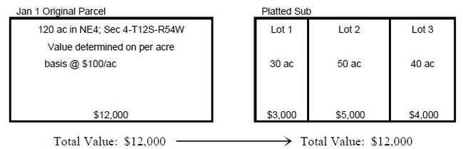
When an area is replatted, the total value of the new parcels must equal the total value of the platted parcels. The new accounts must be flagged to be reviewed the following January 1 for classification and valuation adjustments.
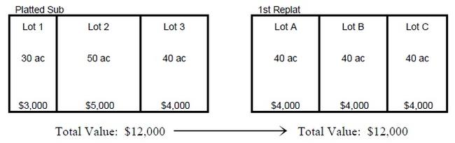
If the replatted lots are further subdivided by a 2nd replat, the total value of the new parcels must equal the total value of the parcels in the 1st replat. Again, the new accounts must be flagged to be reviewed the following January 1 for classification and value adjustments.
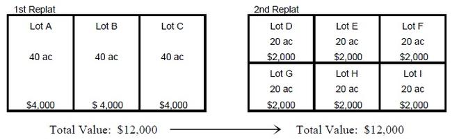
This is a simplified example of allocation of value for replatted subdivisions of vacant land. Each subdivision and replat is unique and often much more complex. When new plats and replats are recorded, the subdivision covenants and declarations should be carefully reviewed by both administrative and appraisal staff before allocating values to the new parcels.
For the most part, allocations should be based on the same valuation unit, e.g., $ per acre, $ per square foot, etc., that was used to value the original parcel as of January 1 of the current year. Care must be taken to ensure that the total taxable value of the original parcel(s) equals the total taxable value of the new parcel(s). The value and classification established January 1 of the current year must not change until the following January 1.
In cases that are more complex, such as the replatting of mixed use properties, planned unit development parcels, condominium projects, or parcels with different zoning or agricultural soil types, these procedures may require more detailed allocation methods. In any case, it is necessary to maintain the classification and value of the original parcel as of January 1.
Splits and Mergers
- Review legal description in the transfer document.
- Locate the appropriate assessment map and plot the new legal on the map.
- Assign new parcel number(s) according to the map numbering sequence.
- Write an abbreviated legal description for metes and bounds descriptions.
- Determine acreage or square footage amounts, if necessary.
- Create new records as needed.
Return source document with new parcel number(s) to the transfer clerk.
Splits and mergers can be processed any time during the year. However, total parcel values are set as of the property status on the assessment date and cannot be increased or decreased for the year of the split or merger. Abstract codes should be assigned based on the use of the property on the assessment date.
Subdivision, Townhome, Condominium, and Pud Plats
- Obtain a copy of the plat.
- Appraisal file (all pages).
- Mapping file (first page only for condo plats).
- Review the plat, locate the appropriate assessment map, and plot the new legal on the map.
- Assign new parcel number(s) according to the map numbering sequence.
- Create new records as needed.
- Transmit a copy of the plat indicating the new parcel numbers to the person responsible for processing plats.
Boundary Changes for Taxing Entity
- Review the legal description in the source document.
- Locate the appropriate assessment map and plot the new boundary on the map.
- Assign new parcel number(s) according to the map numbering sequence if the boundary line splits an existing parcel.
- Update or create new records as needed.
- Return the source document to the person responsible for processing boundary changes.
Formation of a New Taxing Entity
- Accurately identify those parcels that lie within the boundaries of the new district. The legal description and map of the boundaries of the new district should be verified from the source documents.
- Once identified, the boundaries of the new district should be plotted onto the appropriate assessment maps and/or tax area maps.
- A list of the affected parcels based on the assessment or tax area maps should be verified with the assessor’s database. Where necessary, new tax areas should be created and mapped.
Map Maintenance
- Create new assessment maps as necessary when areas become densely platted.
- Manual or automated updates should be made to the assessment map mylars or computer generated maps on a regular basis and new paper copies printed as necessary.
Movable Equipment
All portable or movable equipment, which is not subject to specific ownership taxation such as dog racing gates and trash dumpsters, is valued and assessed as provided in § 39-1-103(5)(a), C.R.S. Also refer to §§ 42-3-102(1) and 103(3), C.R.S.
All owners of this type of property must file a Personal Property Declaration Schedule (Form DS 056). If the equipment is expected to be located in more than one county during the year, the owner indicates the counties and the estimated length of time it will be in each county. The assessor making the original assessment (county in which the equipment is first located during the current calendar year) apportions the value among counties affected according to the portion of the year, in days, the equipment will reside in each. A copy of the value is mailed to the equipment owner and to the assessor of each affected county. The value determined by the assessor of the county of original assessment is used by all county assessors involved, §§ 39-5-113(1) and (2), C.R.S.
However, if the equipment is moved into a county not included in the original apportionment, the assessor of the county requests an amended apportionment of value from the county originating the assessment. Failure to request an amended apportionment results in no assessed valuation for taxes on this equipment for the county not included in the original apportionment. If the amended apportionment of value is received by an assessor after the Abstract of Assessment has been filed, either an abatement or an additional assessment (omitted property) shall be made as necessary, § 39-5-113(3), C.R.S.
An exception is oil and gas rotary drilling rigs which are valued and assessed as provided in § 39-5-113.3, C.R.S.
Refer to ARL Volume 5, Personal Property Valuation Manual, Chapter 7, Special Issues for apportionment procedures.
Ports of Entry – Form 301
Mobile machinery and self-propelled construction equipment is generally registered with the county clerk for payment of annual specific ownership taxes in lieu of ad valorem taxation. Owners of equipment located in Colorado for only a portion of the year can also obtain a prorated registration through a Colorado port of entry. However, if such equipment is operated exclusively on property owned or leased by the owner of the equipment and never operated on a public road, the owner may declare it for ad valorem taxation. If such equipment must be moved through a port of entry, it may be detained without proof that the taxes were paid.
To avoid detention, the owner or agent may list the equipment on Form 301, and have it signed by the assessor or deputy in the county of original assessment. Refer to ARL Volume 5, Personal Property Valuation Manual, Chapter 7, Special Issues for detailed procedures.
Omitted Property
Omitted property consists of any taxable property, such as personal property, land, an improvement, or both land and an improvement, that is not listed on the current assessment roll. A determination must be made as to how long the property has been omitted. Statutory provisions relating to omitted property are listed below.
- Omitted property is valued and assessed for the current year and up to two prior years when the error or omission is the fault of a governmental entity, § 39-10-101(2)(b)(II), C.R.S. If the omission is not the fault of a governmental entity, the omitted property can be valued and assessed for up to six prior years, unless fraud was committed with the intent to evade taxation, in which case there is no limit on how far back taxes can be collected, §§ 39-10-101(2)(b)(I) and (2)(c), C.R.S. However, omitted residential personal property cannot be assessed for a prior year when its discovery occurs as the result of an advertisement for the rental of the real property in which the furnishings are located, § 39-5-125(3), C.R.S. When property is valued for prior years in which it was omitted, the value must reflect the appropriate level of value for each such year. Oil and gas is the exception with omitted property provisions found in § 39-10-101(2)(d), C.R.S.
- Omitted property is added to the assessment roll as soon as the assessor discovers the omission. The assessor is also required to notify the treasurer of any unpaid taxes for prior years, § 39-5-125(1), C.R.S.
- Omissions and corrections on the assessment roll may be processed by the assessor at any time before the tax warrant is delivered to the treasurer, § 39-5-125(2), C.R.S.
- Once the tax warrant is delivered to the treasurer, the assessor notifies the treasurer of the omitted property and then the responsibility for omitted property, omissions, and corrections is assumed by the treasurer. Such actions are often referred to as “treasurer’s assessments,” §§ 39-5-125(2) and 39-10-101(2)(a), C.R.S.
- If the property is not omitted but there is an error in the name of the person owing taxes, the treasurer is to correct the name, and then collect the taxes from the proper party, § 39-10-101(3), C.R.S.
- The county board of equalization shall order the assessor to add to the assessment roll any omitted property which has come to its attention, § 39-8-102(1), C.R.S.
- All persons owning taxable personal property are required to make full and complete disclosure of their personal property for assessment purposes. If an owner does not make full and complete disclosure after two successive schedules have been mailed, or upon whom the assessor or his deputy has called and left one or more schedules, that owner’s taxable personal property is subject to a penalty of up to 25 percent of the assessed value of the omitted property. However, to apply the penalty, the following conditions must exist: 1) the assessor must allow ten days from the date of notification for the owner to make full and complete disclosure, and 2) the assessor must discover the property that was omitted (the Division recommends a physical inspection to discover property and a book audit to determine value), and 3) the owner must have previously filed a declaration schedule, listing his taxable personal property. This penalty also applies to any taxable personal property in a filed schedule which was represented by false, erroneous, or misleading information. For more information on this procedure, refer to ARL Volume 5, Personal Property Valuation Manual.
When adding omitted property valuation after the statutory close of the assessment period (CBOE can add after NOV deadline or assessor can add after CBOE hearings have concluded), care must be exercised to distinguish the difference between truly omitted property and an undervaluation. If the item of personal property, the improvement, or the land was not listed in the appraisal records and/or its value had not been placed on the assessment roll, the property has been omitted. If a value had been placed on the property and the taxpayer received a Notice of Valuation, and it is later discovered that the property has a greater value, the property has been undervalued and the value cannot be increased. Undervaluation does not qualify as omitted property, In Stitches, Inc., v. Denver County Board of County Commissioners, 62 P.3rd 1080 (Colo. App. 2002). The assessor should be prepared to defend omitted property additions to the assessment roll or tax warrant by use of records which substantiate the omission and the value attributable to the property.
Whenever it is discovered that any taxable property has been omitted from the assessment roll, the assessor shall determine the value of the omitted property and list the property on the assessment roll, as follows.
- Determine the number of years the property was omitted. The number of years for which a property can be assessed as omitted is discussed previously under this heading.
- Determine the classification (use) of the property.
- Calculate the value of the property for the current and any prior years it was omitted.
NOTE: The value must reflect the appropriate level of value and, if residential, must reflect the appropriate assessment rate Addendum 3-A, History of Data Gathering Periods and Assessment Rates details the correct level of value and assessment rates for past years. - Assign a parcel number or schedule number to the property, if necessary.
- Add the omitted property to the assessment roll.
Prepare and mail the owner a special notice of valuation (SNOV) and protest form for each year the omitted property is being assessed.
NOTE: You should provide 30 days for the owner to file an objection to the value with the assessor. Owners of real property may also protest the property classification. The assessor must make a decision on the protest and mail a special notice of determination to the owner within thirty days of the date the protest was filed.
If the assessor denies the protest, if the owner disagrees with the assessor’s determination, or if the owner does not receive a special notice of determination, the owner must file an abatement petition with the county after the tax bill is received in order to appeal the assessor’s decision. The abatement petition must be filed within two years of the January 1 following the year in which the taxes are levied. For omitted property, the taxes are levied on the date the tax bill is mailed. The abatement may be filed for any or all years the property was omitted. Refund interest for omitted property accrues from the date the completed abatement petition is filed or the date the taxes were received by the treasurer, whichever is later.
- Notify the treasurer of the taxes due for prior years.
NOTE: The tax calculation must reflect the appropriate mill levy and assessment rates for the omitted tax years. A history of assessment rates is found in Addendum 3-A, History of Data Gathering Periods and Assessment Rates of this chapter.
Omitted Revenue
When taxable property is assigned to the wrong tax area, or when the boundaries of a tax area are drawn incorrectly, some properties listed on the tax warrant may not include the mill levy for one or more taxing entities. Such an event is similar to omitted property in that the properties and their owners may benefit from the services provided by the taxing entity without being subject to the entity’s mill levy. This may result in a loss of revenue to the taxing entity and/or a greater tax burden imposed upon other taxpayers.
When such an omission is caused by assessor error, such as failure to process a recorded inclusion order, the question arises as to whether a correction should be made for prior years or only for the current year forward. Section 39-10-101(2)(a)(I), C.R.S., allows the treasurer to assess and collect taxes for property that was omitted from the tax warrant and not valued for assessment. If the situation above is interpreted literally, the properties in question do not satisfy these requirements.
However, in Aggers, Assessor, v. People Ex Rel. The Town of Montclair, 20 Colo. 348, 38 P. 386 (1894), the court reviewed the occurrence of such an omission and determined that omitted revenue should be collected. In this case, the assessor had failed to extend the mill levies certified over multiple years by the Town of Montclair to property that had been annexed to the town. The town argued that it was entitled to the collection of omitted revenue pursuant to the predecessor statutes to §§ 39-10-101(2)(a)(I) and 39-5-125, C.R.S. The court agreed, finding that although the situation did not fall within the strict letter of statute, it was clearly within its spirit and intent.
The purpose of the statute evidently is to prevent property from escaping taxation through oversight, omission or mistake, and to enable the taxing officers to impose upon all property its just and equal proportion of the public burden. The strict construction contended for by counsel for respondent would prevent the accomplishment of this object and purpose . . . .
No reason can be perceived why the omission to extend or enter the taxes upon property listed and valued would justify the exemption of such property from taxation, when the omission of the property itself from the tax list would not do so (20 Colo., page 351).
The basis for the Aggers decision remains valid today. From the perspectives of the affected parties, namely, the property owner(s), the taxing entity, and the other taxpayers serviced by the taxing entity, when a tax area is assigned incorrectly, the error can result in the non-extension of an entity’s mill levy. The error has the same effect on the parties, as would the omission of the property itself from the tax warrant. Therefore, if the omission was an assessor error, the property is subject to the collection of up to two years’ omitted revenue. A Special Notice of Valuation is not mailed because no change is being made to the value or classification of the property. However, a letter of explanation should be sent to the taxpayer.
If the Board of Assessment Appeals, District Court or an arbitrator orders an increase in value, the assessor makes the correction to the year(s) ordered and presents the order or judgment to the county treasurer who subsequently processes the difference as omitted property according to § 39-10-101(2)(a)(1), C.R.S.
The reporting of omitted revenue to taxing entities on their certification of values is discussed in Chapter 7, Abstract, Certification, and Tax Warrant under 5.5 Percent Statutory Property Tax Revenue Limitation.
Out-of-State Ownership List
The assessor shall furnish annually, by the first day of June to the Department of Revenue a list of the names and addresses of all nonresidents of Colorado who own real and personal property in the county as shown in the assessors records as of the previous assessment date, § 39-5-102(3), C.R.S.
Although the law only requires the name and address of the nonresident, the Department of Revenue requests counties to provide the additional information shown below, using a Microsoft Excel format:
| Column Name | Column Format | Max. Column Length (# of Characters) | Additional Guidelines |
|---|---|---|---|
| County | Text | 35 | The County should be spelled out (i.e., Denver, Weld) |
| Parcel | Text | 35 | |
| SubClass | Text | 20 | |
| Owner Name1 | Text | 100 | |
| Owner Name 2 | Text | 100 | |
| Owner Address1 | Text | 100 | The Address fields should be in one column (W 123 S Main Blvd) , not broken up into separate columns (W), (123), (S),(Main),(Blvd) |
| Owner Address 2 | Text | The Address fields should be in one column (W 123 S Main Blvd) , not broken up into separate columns (W), (123), (S),(Main),(Blvd) | |
| Owner City | Text | 50 | |
| Owner State | Text | 2 | |
| Owner Zip | Text | 9 | |
| Physical Address | Text | 50 | The Address fields should be in one column (W 123 S Main Blvd) , not broken up into separate columns (W), (123), (S),(Main),(Blvd) |
| Location City | Text | 50 | |
| Actual Value | Currency | 99,999,999,999.00 | The Actual Value field doesn’t have an actual set length, but the field should be a Currency format with two (2) decimals. |
The data may be e-mailed, or a CD or disk may be mailed to the address below.
Department of Revenue
Audit Selection Committee
Attn: Mr. Lauren Hagge
720 South Colorado Boulevard, North Tower, Suite 400N
Denver, CO 80246
Phone: 303-692-7938
Email: lauren.hagge@state.co.us
Questions concerning electronic submissions should be directed to the Audit Selection Committee at the above telephone number.
Personal Property Issues
After the Assessment Date
If a firm commences business after the assessment date, the property is taxable January 1 of the year following the year it is put into use, § 39-5-110(1), C.R.S. When personal property is newly acquired and put into use, it becomes taxable the following January 1 if the property is used for business purposes, § 39-3-118.5, C.R.S. If the property is in storage, it does not become taxable until January 1 following the year it is put into use, §§ 39-5-104.5 and 110, C.R.S. Refer to ARL Volume 5, Personal Property Valuation Manual, for further information.
The personal property of a firm that quits business after the assessment date is taxable for the entire year, § 39-5-104.5, C.R.S. If either the assessor or treasurer believes that personal property may be removed, dissipated, or distributed so that taxes may not be collected, the treasurer may proceed to collect the taxes immediately, and, if necessary, distrain, seize, and sell the personal property, §§ 39-10-111(1)(a), and 113(1)(a) and (2), C.R.S.
If business personal property is destroyed by a natural cause after January 1 of any tax year, the value for the year of the event is not prorated. However, if all the property that is listed on a single schedule was destroyed, the total assessed value of the account should be tracked for the report to the county treasurer of property taxes that are reimbursable by the state per § 39-1-123, C.R.S. Refer to Chapter 4, Assessment Math.
Incentive Payments
A county, municipality, or special district can enter into negotiations for an incentive payment with owners of new business facilities. A county, municipality, or special district may also negotiate an incentive payment or credit with owners of existing business facilities, located in their jurisdiction, based on verifiable documentation demonstrating that there is a substantial risk that the owner of the existing business facility will relocate it out of state. The incentives cannot exceed 100 percent of the personal property taxes paid to the county, municipality, or special district. For agreements made prior to August 6, 2014, the agreement cannot last more than ten years. For agreements made after August 6, 2014, the agreement may not last longer than thirty-five years, §§ 30-11-123, 31-15-903, and 32-1-1702, C.R.S. Additional incentives are available through income tax credits, real property tax incentives, and sales tax refunds. For further information on these incentives refer to §§ 39-30-105.1 and 107.5, C.R.S.
Personal Property Moved in or Out of State After January 1
Personal property is valued as of the assessment date and is valued for the entire year regardless of any destruction, conveyance, relocation, or change in taxable status, § 39-5-104.5, C.R.S. Personal property removed during the assessment year is taxable for the entire year, § 39-5-104.5, C.R.S. The owner of any personal property that is removed from the state is liable for the entire tax obligation, § 39-5-110(2), C.R.S. When taxable personal property is brought into the state after the assessment date, the owner must complete and file with the assessor a personal property declaration schedule if the actual value of the personal property exceeds the exemption threshold shown below, § 39-5-110, C.R.S.
Personal property is exempt if its actual value is equal to or less than the exemption threshold shown for the applicable tax year. Exempt personal property accounts should be flagged and reviewed annually.
| Tax Year | Exemption Threshold |
|---|---|
| 2009 – 2010 | $4,000 |
| 2011 – 2012 | $5,500 |
| 2013 – 2014 | $7,000 |
| 2015 – 2016 | $7,300 |
| 2017 – 2018 | $7,400 |
| 2019 – 2020 | $7,700 |
| 2021 – 2022 | $50,000 |
| 2023 - 2024 | $52,000 |
| Thereafter | Inflation factor calculated by the Division |
Exemption of Consumable Personal Property
In 2000, the general assembly amended § 39-3-119, C.R.S., to require the Division of Property Taxation to “publish in the manuals, appraisal procedures, and instructions prepared and published pursuant to § 39-2-109(1)(e), a definition or description of the types of personal property that are ‘held for consumption by any business’ and therefore exempt from the levy and collection of property tax pursuant to this section."
The Division has developed two criteria to aid in determining whether personal property is considered consumable, and therefore, exempt from property taxation. To be classified as “consumable,” personal property must fall under one of the two criteria identified below:
The personal property must have an economic life of one (1) year or less.
This criterion applies to any personal property regardless of original acquisition cost. This category also includes non-functional personal property that is used as a source of parts for the repair of operational machinery and equipment.
The personal property has an economic life exceeding one year, but has an acquisition cost, inclusive of installation cost, sales tax, and freight expense to the point of use, of $350 or less.
The $350 personal property threshold applies to the acquisition cost of the personal property as completely assembled for use in the business, not the personal property’s unassembled, individual component parts.
For leased equipment having a “buyout” provision occurring during or at the end of a lease, the fair market value of the personal property, including installation, sales tax, and freight to the point of use, at the time the initial agreement is executed, is to be used as the acquisition cost for the purposes of the $350 threshold.
Processing Declarations
- Date stamp declaration schedule.
- Verify that the declaration schedule was timely filed.
NOTE: If the schedule is filed after the deadline, it is necessary to staple the envelope showing the postmark to the declaration schedule. - Match declaration schedule with personal property file.
- Review for address and/or ownership changes and for owner’s social security number or federal identification number.
- Review the Personal Property Declaration Schedule. Determine if the form was properly completed and signed by the property owner or agent. The itemized list of personal property may be shown on the declaration schedule or furnished on an exhibit attached to the declaration schedule, § 39-5-108, C.R.S.
- Review the file for audit notes or other documentation that should be referenced during processing.
- Review the current personal property record and make necessary adjustments. Review and reconcile the asset listing and/or depreciation schedule. Check for other assets that may not be listed in the addition and deletion portion of the declaration schedule.
- Check for leased equipment reported on the declaration schedule. This tracking can be done manually or electronically.
- Enter property changes into the computer system.
- File personal property record.
Physical Inspection of Real Property – Guidelines
A notice should be placed in a local newspaper stating that the assessor’s office is conducting property inspections in specified neighborhoods. The notice should also indicate that the appraiser will leave an informational door hanger to schedule an appointment if no one is home. Each assessor’s office should develop a property inspection form to assist appraisers as a check list for conducting efficient, thorough and uniform inspections.
Prior to Field Inspection
- Contact the property owner and establish a time to inspect the property.
- Pull and review the appraisal records and all the pertinent information (building permits, TD-1000, sales verification letters, agricultural classification questionnaires, etc.) that pertains to the property.
- If the location of the property is unknown, obtain and reference an assessment map to identify the property location.
- Make sure the following items are available and in working order:
- Camera and memory card
- Measuring tape
- Flashlight
- Calculator
- Protective wear (boots/old shoes, rain gear, etc.)
- County identification
- Paper and pencil
- Property inspection forms.
- Pertinent subject properties’ appraisal records
Field Inspection
- Visually survey the neighborhood. Note neighborhood appearance, street traffic, location of street lights, amenities, existing obsolescence, etc.
NOTE: If no one is home, leave an informational door hanger so the property owner can schedule an appointment for the inspection. - Visually survey the property site. Identify installed utilities, parcel size, parcel shape, parcel location within the block/surrounding area, excess land, topography, location of structures, drainage, evidence of agricultural use, etc.
- Make a careful inspection of the interior finish, recording the details in the appropriate place on the property record card. Using a characteristic check sheet to inventory the interior can assist in capturing all pertinent data. Note the floor plan (basement or other floors), room counts, plumbing, fireplaces, type of heating, material quality, physical condition, functional obsolescence, general condition, necessary repairs, etc.
- Inspect the exterior of the structure(s), including the rear of structure. Check all decks, garages, outbuildings, concrete slabs, etc. Make a note of the property condition, material quality, needed repairs, roof type, etc.
- Verify the property classification. Compare the property with the base specifications in Chapter 6, Property Classification Guidelines and Assessment Percentages, to find the proper class and subclassification. Note any changes in property use.
Measure the structure(s). If the structure is newly constructed, measure the entire structure. Typically, the measurement should start with the side that has the least number of angles. The starting point should be clearly marked on the grid created by the appraiser. The measurements can be spot checked if the structure has been previously measured. Make note of bay windows, second stories which extend over the first story, etc. Make sure all measurements close before leaving the site.
NOTE: If your county has a building department, you may want to review the plans of particularly difficult structures.
The appraiser should make a scaled sketch of each level of the structure and show a calculation of square feet and/or cubic feet areas. When calculating square footages, areas that are not finished should be separately identified. The sketch should show the location of each structure in relation to others and in relation to the land parcel.
- Take a photograph of the major structures. Take photographs of anything that may aid in the valuation of the property. Note the photo identification numbers on the field inspection sheet. As an alternative to a photograph, a video camcorder can be very effective in capturing the property and comparable properties.
For additional information on physical inspections, refer to:
- Chapter 8, Assessment Planning Guidelines.
- Course material from Appraisal 114, Design and Measurement Workshop, Division of Property Taxation.
- The Appraisal of Real Estate, American Institute of Real Estate Appraisers, 2008, Chapters 10 and 11.
Possessory Interests
Possessory Interest Definition
For purposes of the procedures, the Division of Property Taxation defines possessory interest as:
A private property interest in government-owned property or the right to the occupancy and use of any benefit in government-owned property that has been granted under lease, permit, license, concession, contract, or other agreement.
Generally, possessory interests constitute a right to the possession and use of government property for a period of time less than perpetuity. It represents a portion of the bundle of rights that would normally be included in a fee ownership; and its value, therefore, is typically something less than the value in perpetuity of the whole bundle of rights.
See ARL Volume 3, Real Property Valuation Manual, Chapter 7, Special Issues in Valuation, Assessment of Possessory Interest, for further information.
Tax Area Assignment
Possessory interest properties will be taxed by a minimum of the county and a school district. The inclusion of property in other taxing entities must be determined using county and taxing entity records, to the best of your ability.
School district boundary information is available from the school district and/or the Department of Education.
When assigning a tax area for possessory interests, it would be reasonable to use the location of the operation as the determinate factor for establishing the tax area or in the case of multiple counties, the county/tax area where the operation is based. However, all counties involved need to be in agreement with this assignment.
Apportionment of Possessory Interest Values in Land Between Two or More Counties
In most circumstances, possessory interests are located in a single county and no apportionment is necessary. However in some instances, use of land or other types of possessory interests operate in more than one county and thus require an apportionment of the actual value of the possessory interest to each county.
In the case of agricultural grazing possessory interests, the federal and state agencies have been able to provide the exact acreage of each allotment within each county.
In the case of river-rafting permits the launch site location is to be used in determining the county as well as the taxing district to assign to the account.
For guide and outfitter operations located in multiple counties it would be reasonable to assign the base-site of the operation as the location and the tax area.
Each county will send a tax bill for its apportioned share of the total value.
Minimum Values
The law does not provide for minimum assessments on real or personal property. What is allowed is the collection of a $5 administrative fee when a real property tax amount is less than $10, § 30-1-102(3), C.R.S.
Counties considering a minimum assessment should discuss the issue with the county attorney, as the county attorney defends the assessor’s actions if a taxpayer challenges the minimum value.
Property Description
The property description for a possessory interest will vary, depending on the information available and whether the lessor is the U.S. Forest Service, the State Land Board, etc. Based on the information available from each lessor, the assessor should establish a standard for possessory interest descriptions. Below are suggested items that might be included, if available, in the description:
- Principal meridian (if there is more than one survey area in the county)
- Section, township and range
- Lease/permit/authorization number
- Lessor
- Contract date (start-up)
- Expiration date
- Park name
- Acreage of parcel
Examples:
- Possessory interest in State Land Board land in section 36, township 11 north, range 52 west of the 6th Principal Meridian, containing 640 acres, per lease number 01123.
- Possessory interest in BLM land, authorization number 0505715, start-up 2/28/99, expiring 2/28/09.
Parcel Numbering
A parcel number may be assigned to a possessory interest property but because the possessory interest is tied to a permitted use and not necessarily to real property described by section, township, and range using a fourteen-digit parcel number may not be appropriate. Therefore, to create consistency, a county could consider using arbitrary schedule numbers to identify possessory interest properties.
Classification and the Abstract of Assessment
The abstract codes for possessory interests are listed in Chapter 6, Property Classification Guidelines and Assessment Percentages. The possessory interest values are listed by class for each city and town and school district in the abstract.
Collection of Taxes
The property tax on a possessory interest in real or personal property must be assessed to the holder of the possessory interest and collected in the same manner as other property taxes; except that the property tax on a possessory interest cannot become a lien against the real or personal property. When due, the property tax becomes a debt due from the holder of the possessory interest to the board of county commissioners or to such other body as is authorized by law to levy property taxes, and will be recoverable by the board or body by direct action in debt on behalf of each governmental entity for which a property tax levy has been made, § 39-1-107(4), C.R.S.
The debt action would be initiated by the treasurer and would involve the county commissioners and county attorney.
Predatory Animal Control
Colorado statutes provide for a predatory animal control program, implemented by the Department of Agriculture, for the protection of sheep, §§ 35-40-100.2 through 207, C.R.S. A local protection program may be implemented by the county commissioners through a county-wide license fee on sheep and/or cattle for local control of predatory animals. At present, no county uses this program for cattle.
The board of county commissioners has the power to establish a license fee to defray the expense of the predatory animal control program. By October 1 of each year, the Colorado Sheep and Wool Board must provide the assessor with a certified list containing all the information necessary to implement the program. The information consists of the name and address of each sheep owner in the county, the number of sheep that were marketed during the immediately preceding twelve months, § 35-40-205, C.R.S.
The assessor, after receiving the list of names and number of sheep, transmits the list to the board of county commissioners by November 1, § 35-40-205, C.R.S. The county commissioners then order (by resolution) that the county license fee be levied against all sheep herded or grazed in the county during the previous year, § 35-40-205, C.R.S.
The resolution becomes very important in the control and collection of delinquent county predatory animal sheep fees. It is the opinion of some county attorneys that without such a resolution, the collection of delinquent county sheep fees may not be enforceable.
Upon the order of the board of county commissioners, the assessor enters on the property tax roll the amount of the county sheep fees due from each sheep owner. This is a sheep license fee, not a property tax assessment. However, when levied, it becomes a lien upon the property of the sheep owner, enforceable under the personal property tax collection laws. When collected, the fees are credited by the county treasurer to the county predatory animal control fund, § 35-40-205(2), C.R.S.
Real Property Leased and Used by the State, a Political Subdivision, or a State-Supported Institution of Higher Education
Real property that is used by the state, a political subdivision, or a state-supported institution of higher education (qualifying entity) pursuant to the provisions of a lease or rental agreement for at least a one-year term is exempt from property taxation. State-supported institutions of higher education include, but are not limited to, all post-secondary institutions including junior colleges and community colleges, extension programs of the state-supported universities and colleges, local district colleges, area technical colleges, and the institutions governed by the regents of the University of Colorado. A political subdivision is defined in § 39-1-102(12), C.R.S., as any governmental entity that has the authority to levy a property tax. The exemption is not extended to leases where the federal government is the tenant.
The exemption applies to existing leases and new lease agreements entered into or renewed on or after January 1, 2009, § 39-3-124(1)(b), C.R.S. The discovery mechanism for the assessor’s office is the receipt of a copy of the lease (including subleases, as long as the space is used by a qualifying entity) from the lessee, § 39-3-124(1)(b)(I), C.R.S. The lessee is also required to notify the assessor’s office if the lease terminates before the stated term expires.
The value associated with the change in taxable status must be tracked and reflected on certifications of value to taxing entities.
Effective June 1, 2009, upon receipt of a lease or rental agreement, § 39-3-124(1)(b)(I)(B), C.R.S., requires that the assessor send a notice to the landlord acknowledging receipt of the lease or rental agreement. The notice must identify the property, the property address, and the parties to the lease or rental agreement. The assessor may provide notice of leases received prior to June 1, 2009, as a courtesy to taxpayers.
Procedures
- Identify the property being leased and pull the property record.
- Review the lease:
- Verify landlord is owner of record. If the ownership does not match, contact the lessee.
- Verify lessee is a qualifying entity.
- Determine the lease start and end dates. To qualify for exemption, the term must be for at least one year.
- Identify leased area. Lease renewal documents or amended leases must be reviewed to determine if the property described under the new lease was changed from the previous lease
- Determine the value of the land and improvements that will be designated as taxable and exempt, based on the area described in the lease.
- If 100% of the property is leased, then 100% of the value will be exempt and prorated based on the start date of the lease.
- If only part of the property is leased to a qualified entity, the statute is silent on how the exempt value is to be determined. Therefore, it is at the discretion of the assessor to determine which method provides the most reliable indication of value. The most commonly used method is proration based on the actual square footage described in the lease. An alternative method is proration based on income.
- Calculate the prorated exempt and taxable value for the land and improvement, based on the lease start date. See Property Changing Taxable Status, Chapter 4, Assessment Math for a calculation example and Chapter 9, Forms Standards for an example of the Special Notice of Valuation.
Assign a classification code to the exempt portion of the land and improvement and change the assessment roll records. The taxable portion of the land and improvement will retain the classification code assigned to the property as of January 1. It is not necessary to create separate schedule numbers for the exempt and taxable values; multiple class codes may be carried on a single property record.
The recommended exempt classification codes for this type of exempt property are: Leased (Non Residential), 9195 (land), 9295 (improvements); Leased (Residential), 9196 (land), 9296 (improvements). Refer to Chapter 6, Property Classification and Assessment Percentages.
- Set up three computer tracking flags:
- Track the lease expiration date.
- If the first year value is a prorated value, change the prorated exempt value to the full exempt value the following January 1.
- Certification of Values: For TABOR, track the actual value of real property changing from taxable to exempt as the result of a new lease, and track the actual value of real property changing from exempt to taxable when the lease expires. Track the full value of the property subject to the change.
- When the lease terminates or if the lease ends early, prorate the value and issue a Special Notice of Valuation reflecting the change in status from exempt to taxable. Refer to Special Notices of Valuation in this chapter. Property Changing Taxable Status in Chapter 4, Assessment Math for proration procedures and Chapter 9, Form Standards, for procedures and a sample of the Special Notice of Valuation.
For statutory information, refer to Real Property Leased to the State or Political Subdivision in Chapter 10, Exemptions.
Senior Citizen, Veteran with a Disability and Gold Star Spouse Exemptions
In 2000, voters adopted section 3.5 of article X of the Colorado Constitution, creating a property tax exemption for qualifying senior citizens and their surviving spouses. A qualifying senior citizen is an individual who was at least 65 years of age on January 1 of the year of application and who owned and occupied the property as his or her primary residence for at least 10 consecutive years prior to January 1. Voters expanded the program in 2006 to include “qualifying veterans with a disability.” A “qualifying veteran with a disability” is an individual who sustained a service-connected disability rated by the Federal Department of Veterans Affairs as a 100 percent permanent disability through disability retirement benefits pursuant to a law or regulation administered by the Department, the United States Department of Homeland Security, or the Department of the Army, Navy, or Air Force. Effective January 1, 2015, the surviving spouse of a qualifying veteran with a disability may apply for the exemption on the primary residence that previously received an exemption, § 39-3-203(1.5)(a.5), C.R.S. In 2022, voters approved a ballot measure to extend the exemption to the surviving spouses of a “Gold Star Veteran” who died in the line of duty and veterans who died as a result of a service-related injury or disease.
For those who qualify, 50 percent of the first $200,000 in actual value of their primary residence is exempted for a maximum exemption amount of $100,000 in actual value. The state will pay the property tax on the exempted value.
The requirements for obtaining any of the exemptions are discussed under Eligibility below. The application forms and the required annual notice and brochure about the programs are covered in Chapter 9, Form Standards. This section discusses the administration of the exemptions and provides scenarios of properties that would or would not qualify. The application for Gold Star Spouses will be available in January of 2023.
Annual Notice
No later than May 1 each year, the assessor must send a notification and the instructions for obtaining proof of qualifying veteran with a disability status to all residential property owners explaining the existence of the exemption programs. Effective January 1, 2014, the notice for the senior exemption must be included with the treasurer’s tax bill in January. If the notice for the veteran with a disability exemption is not also included in the treasurer’s tax bill in January, the assessor must include it with the assessor’s Real Property Notice of Valuation in May, or send it as a separate mailing, § 39-3-204, C.R.S. Language for the notice is discussed in Chapter 9, Form Standards.
Eligibility for the Senior Citizen Exemption
Applicant as Qualifying Senior Citizen, § 39-3-203(1)(a)(I), C.R.S.
- The applicant (qualifying senior citizen) must be at least 65 years old on January 1 of the year in which he/she applies; and
- The applicant (qualifying senior citizen) must be the owner of record and must have been the owner of record for at least 10 consecutive years prior to January 1. Ownership can be limited to a fractional, joint, life estate interest, trust, a corporate partnership, or other legal entity solely for estate planning purposes; and
- The applicant (qualifying senior citizen) must occupy the property as his/her primary residence, and must have done so for at least 10 consecutive years prior to January 1. A primary residence is the place at which a person’s habitation is fixed and to which that person, when absent, has the intention of returning. A person can have only one primary residence at any time.
Applicant as Surviving Spouse, § 39-3-203(1)(a)(II), C.R.S.
- The applicant (surviving spouse) must have been legally married to a senior citizen who met the above requirements on January 1 of the year the senior citizen passed away; and
- The spouse (qualifying senior citizen) passed away on or after January 1, 2002; and
- The spouse (qualifying senior citizen) was at least 65 years old on January 1 of the year he/she passed away; and
- The spouse (qualifying senior citizen) occupied the property as his/her primary residence on January 1 of the year he/she passed away and for at least 10 consecutive years prior to that date; and
- The spouse (qualifying senior citizen) and/or applicant was the owner of record on January 1 of the year the spouse passed away, and for at least 10 consecutive years prior to that date. (During any time in which ownership was held by the applicant and not the spouse, the applicant also occupied the property as his/her primary residence); and
- The applicant (surviving spouse) cannot have remarried; and
- The applicant (surviving spouse) must occupy the residential real property as his/her primary residence and must have done so with his/her spouse (qualifying senior citizen). The applicant does not have to meet the 10-year occupancy requirement.
Eligibility for the Veteran with a Disability Exemption
Applicant as Qualifying Veteran with a Disability, §§ 39-3-202(3.5) and 39-3-203(1.5)(a), C.R.S.
- The applicant must be a veteran who sustained a service-connected disability rated by the Federal Department of Veterans Affairs as a 100 percent permanent disability through disability retirement benefits pursuant to a law or regulation administered by the Department, the United States Department of Homeland Security, or the Department of the Army, Navy, or Air Force; and
- The applicant must be an honorably discharged veteran; and
- The applicant must be the owner of record and must have been the owner of record since January 1. Ownership can be limited to a fractional, joint, life estate interest, trust, a corporate partnership, or other legal entity solely for estate planning purposes; and
- The applicant must occupy the property as his/her primary residence, and must have done so since January 1. A primary residence is the place at which a person’s habitation is fixed and to which that person, when absent, has the intention of returning. A person can have only one primary residence at any time.
Applicant as Surviving Spouse, § 39-3-203(1.5)(a.5), C.R.S.
- The applicant must have been legally married to a veteran with a disability who met the above requirements on January 1 of the year the veteran with a disability with a disability passed away.
- The spouse (qualifying veteran with a disability) must have been previously qualified as a veteran with a disability by the Division of Veteran’s Affairs and must have been previously receiving the property tax exemption on his/her residence.
- The spouse (qualifying veteran with a disability) must have occupied the property as his/her primary residence on January 1 of the year he/she passed away.
- The applicant (surviving spouse of qualifying veteran with a disability) cannot have remarried; and
- The applicant (surviving spouse of qualifying veteran with a disability) must occupy the residential real property as his/her primary residence and must have done so with his/her spouse (the qualifying veteran with a disability).
Applicant as Gold Star Veteran Surviving Spouse, section 3.5 of article X of the Colorado Constitution
- The applicant must have been legally married to a Gold Star Veteran who met the above requirements on January 1 of the year the veteran passed away.
- The deceased spouse must have been a qualifying Gold Star Veteran
- The spouse of the qualifying Gold Star Veteran must have occupied the property as his/her primary residence on January 1 of the year the veteran passed away.
- The applicant (surviving spouse of qualifying Gold Star Veteran cannot have remarried; and
- The applicant (surviving spouse of qualifying Gold Star Veteran) must occupy the residential real property as his/her primary residence and must have done so with his/her spouse (the qualifying Gold Star Veteran).
Exceptions to Ownership and Occupancy Requirements
If any of the ownership and occupancy requirements are not met due to one or more of the reasons listed below, the applicant can still qualify for the exemption. Applicants for the senior citizen exemption who fall under any of these exceptions must complete the Long Form.
- Title to the property is held by the spouse of the qualifying senior citizen or veteran with a disability. During any time in which the ownership requirement is met by ownership in the spouse’s name, the spouse must occupy the property with the qualifying senior citizen or veteran with a disability as his/her primary residence, §§ 39-3-202(2)(a)(II)(A) and (B), C.R.S.
- Title to the property was transferred to or purchased by a trust, “corporate partnership,” or other legal entity solely for estate planning purposes. The qualifying senior citizen, veteran with a disability, or spouse, is a maker of the trust or a principal of the “corporate partnership” or legal entity. Had the transfer not occurred, the qualifying senior citizen, veteran with a disability, or spouse, would be the owner of record. If the spouse would otherwise be the owner, the spouse must occupy the property as his or her primary residence, or must have done so when alive. If the property is owned by a trust, the trust must have been established by a written trust agreement, §§ 39-3-202(2)(a)(III), (IV), and (V), C.R.S.
- The qualifying senior citizen, his/her spouse or surviving spouse, or the veteran with a disability or his/her spouse is/was confined to a hospital, nursing home, or assisted living facility. If not for confinement, the individual would meet the appropriate occupancy requirement. While confined to the health care facility, the property was occupied by the spouse of the person confined, a financial dependent, or it remained unoccupied, § 39-3-202(2)(b), C.R.S.
- The qualifying senior citizen’s prior home was condemned in an eminent domain proceeding by a governmental entity, or it was sold to a governmental entity upon threat of condemnation by eminent domain. Had this not occurred, the qualifying senior citizen would meet the 10-year ownership and occupancy requirements on the prior residence. Since condemnation, the qualifying senior citizen has not owned and occupied other property as his/her primary residence other than the one for which exemption is sought, § 39-3-203(6)(a)(I), C.R.S.
- The qualifying senior citizen’s prior home was destroyed or otherwise rendered uninhabitable by a natural disaster. Had this not occurred, the qualifying senior citizen would meet the 10-year ownership and occupancy requirements on the prior residence. Since the destruction by a natural disaster, the qualifying senior citizen has not owned and occupied other property as his/her primary residence other than the one for which exemption is sought, § 39-3-203(6)(a)(I)(1.5), C.R.S.
Limitations
- The application for the senior citizen exemption must be filed by July 15 of the year for which the exemption is requested. The filing deadline for the veteran with a disability exemption is July 1. Filing will be considered timely if the application is postmarked no later than the application deadline, § 39-3-205(1), C.R.S. If the application is not filed by July 15, the assessor must accept late applications through August 15; however, applicants will not have appeal rights for applications filed after July 15, § 39-3-206(2)(a.7), C.R.S. The county assessor is authorized to waive the application deadline and accept an application for the veteran with a disability exemption if filed on or before August 1, if the applicant can show good cause for not filing by July 1, § 39-3-206(2)(a.7), C.R.S. Standards for determining “good cause” are discussed under Late Applications below.
- All required fields on the application must be completed, or the application cannot be approved. This includes a requirement that the application list the social security number of each person who occupies the property, § 39-3-205(1), C.R.S. In rare instances, an occupant or applicant may be listed who does not have a social security number but receives benefits under the number of another person. For such individuals, the application might list the social security number of the other person, along with a letter suffix. However, according to the Social Security Administration, when an application is completed in this manner, the person in question generally does have a social security number, but has used the spouse’s number with a letter suffix for so long that he or she has forgotten about the existence of his or her own number. Therefore, when an application includes a social security number with a letter suffix, the person in question should be contacted and encouraged to verify the status of his or her own social security number. If the individual does so, but says that the Social Security Administration confirmed that he or she does not have a number, the application can be approved, and the number with the letter suffix should be used.
- Under no circumstances will an exemption be allowed for any property taxes assessed prior to the year in which the qualified individual first files a timely exemption application, § 39-3-203(1)(b), C.R.S.
- Once an exemption application is filed and approved, the exemption remains in effect for subsequent years, unless the home is sold or the qualifying applicant no longer uses the home as his/her primary residence, § 39-3-205(1), (2)(b) and (3)(b), C.R.S.
- Statute requires that notice be given to the county assessor within 60 days of any change in the ownership or occupancy that would prevent an exemption from continuing, §§ 39-3-205(2)(b) and (3)(b), C.R.S. Once the property no longer qualifies for exemption, the exemption is removed the following January 1.
- If a qualified individual owns a unit in a condominium, as defined in § 38-33.3-103(8), C.R.S., or owns multiple dwelling units in which the qualified individual occupies one of the units, an exemption will be allowed only with respect to the dwelling unit that the individual occupies as his/her primary residence, § 39-3-203(3), C.R.S.
- No more than one exemption per property tax year will be allowed for a single dwelling unit of residential real property, regardless of how many qualified individuals use the home as their primary residence, or whether one or more owner-occupiers qualify for both the senior citizen and veteran with a disability exemptions, § 39-3-203(4), C.R.S.
- Two individuals who are legally married and who own more than one residential real property, shall be deemed to occupy the same primary residence and may claim no more than one exemption, § 39-3-203(5), C.R.S.
- An owner occupier who claims an exemption on a property that he or she has not actually owned and occupied as his or per primary residence for the ten years preceding the assessment date shall provide the assessor any information the assessor may reasonably require to verify the owner-occupier is entitled to an exemption, § 39-3-203(6)(b), C.R.S.
Required Forms
Application forms and a brochure have been created for the exemptions. The documents are available at the following website, or by calling the Division at (303) 864-7777.
Making Application
Senior Citizen Exemption
Senior citizens must file a completed application with the assessor no later than July 15 of the year for which they are first seeking exemption. The application is considered timely filed if postmarked by July 15, § 39-3-205(1)(a), C.R.S. This is a confidential document. The assessor must accept late applications until August 15. See Late Applications below.
Veteran with a Disability Exemption
Pursuant to § 39-3-205, C.R.S., veterans with a disability must file a completed application with their county assessor no later than July 1 of the year for which they are first seeking exemption. The application is considered timely filed if postmarked by July 1, § 39-3-205(1)(b), C.R.S. This is a confidential document. Late applications may be accepted until August 1 if the applicant can show good cause for missing the July 1 deadline. See Late Applications.
Application forms can be obtained from the web site of the Colorado Division of Property Taxation forms.
Surviving spouses of a previously qualified veteran with a disability may apply for a continuation of the exemption by submitting a Veteran with a Disability Surviving Spouse application form to the county assessor's office no later than July 1.
Approval or Denial of Application
Senior Citizen Exemption
The assessor approves or denies all applications for the senior citizen exemption. The application period begins on January 1 and ends on July 15 (August 15 for late applications) of each year. Assessors should not provide new applications to taxpayers or accept completed exemption applications outside of this period, § 39-3-206(2)(a.5), C.R.S.
The legal requirements for exemption are discussed under Eligibility for the Senior Citizen Exemption. Example scenarios are provided later in this section. It is recommended that the assessor begin the review process as soon as possible so that applicants who file incomplete applications, or who need to submit additional documentation, have sufficient time to provide what is needed within the time frame allowed.
If one or more of the requirements for exemption are not met, or if the application is incomplete, the assessor mails a letter by August 1 explaining the reason(s) for denial. The letter must describe the procedure for appealing the denial, § 39-3-206(1)(b), C.R.S.
Under no circumstances shall an exemption be allowed for property taxes assessed during any tax year prior to the year in which the senior citizen first files an exemption application § 39-3-203(1)(b), C.R.S.
Because the exemption is not a “state or local public benefit” as defined in § 24-76.5-102(3), C.R.S., the assessor need not verify that the applicant is lawfully present in the United States.
Veteran with a Disability Exemption
Pursuant to § 39-3-205, eligible veterans with a disability will apply to their county assessor’s office. The Colorado Department of Military and Veterans' Affairs will create a set of guidelines that the county assessor will use to determine eligibility based on the veteran's application and their proof of qualifying veteran with a disability status.
If one or more of the requirements are not met, or if the application is incomplete, the assessor mails a letter no later than August 1 explaining the reason(s) for denial. The letter must describe the procedure for appealing the assessor’s denial, § 39-3-206(1.5)(b), C.R.S. Under no circumstances shall an exemption be allowed for property taxes assessed during any tax year prior to the year in which the veteran first files an exemption application.
Only One Exemption Allowed
No more than one exemption per tax year shall be allowed for a residential property, even if one or more of the owner-occupiers qualify for both the senior citizen exemption and the veteran with a disability exemption. If an individual or married couple applies for either or both the senior citizen and veteran with a disability exemptions on more than one property, the exemptions shall be denied on each property §§ 39-3-203(4) and 39-3-207(2)(a)(I), C.R.S.
Additional Procedures
Prior to August 1, the clerk and recorder publishes notice in at least one issue of a county newspaper of the dates the county board of equalization will hear appeals of denied exemptions, § 39-8-104(2)(b), C.R.S. The notice should appear in at least one issue of a local newspaper, or if no local newspaper exists, the notice should be posted in the offices of the assessor, the treasurer, the clerk and recorder, and in at least two other public places located in the county seat, § 39-8-104(3), C.R.S.
Timely applications should be processed and entered into the assessor’s CAMA system no later than August 1. Late applications should be processed and entered no later than September 1.
No later than August 15, a taxpayer may contest the assessor’s denial by requesting a hearing before the county board of equalization, § 39-3-206(2)(a), C.R.S.
From August 1 through September 1, the county board of equalization hears appeals from applicants denied exemption, § 39-3-206(2), C.R.S. The assessor should be present to explain the reasoning for the decisions.
No later than September 10, the assessor completes all application processing for the year and then submits a report to the Administrator that includes a list of the properties granted either exemption, § 39-3-207(1), C.R.S. Data required for the report is discussed later in this section.
NOTE: Exemptions added by the county after September 10 are not eligible for reimbursement by the state if they were not included in the assessor’s first (September 10) report to the Administrator.
The Administrator reviews the reports of all assessors to identify applicants who submitted an exemption application without meeting all legal requirements for claiming the exemption. No later than November 1, the Administrator notifies applicants who:
- claimed an exemption to which they are not entitled.
- are a married couple and claimed separate exemptions.
- do not own and/or occupy the property as their primary residence.
- are otherwise ineligible to claim an exemption.
The notification to the applicant shall include reasons for the determination of ineligibility. The denial notice includes instructions for appealing the denial to the Administrator, § 39-3-207(2)(a)(I), C.R.S.
Taxpayers denied exemption by the Administrator can appeal no later than November 15. When appealed, the Administrator requests from the appropriate assessors a copy of each exemption application submitted by the applicant. The appeal is decided accordingly. If the applications remain denied, the Administrator mails a denial letter and a copy of each application filed by the applicant, § 39-3-207(2)(a)(II), C.R.S.
No later than December 1, the Administrator sends written notice to each affected assessor of the properties which were denied by the Administrator because the applicants have claimed exemption without meeting legal requirements for doing so, § 39-3-207(2)(b), C.R.S. The assessor removes these exemptions prior to delivery of the tax warrant.
No later than January 24, each assessor shall forward to the Administrator a partial copy of their county tax warrant that includes only properties granted an exemption. The Administrator will examine the tax warrant to ensure that no additional exemptions have been allowed since the Administrator examined the assessors’ first reports, which were previously sent to the Administrator no later than September 10 as described above, and that all exemptions denied by the Administrator have been removed. The Administrator will notify assessor and treasurer of any exemptions to be removed from the tax warrant no later than January 31. See Assessor and Treasurer Reports below for the specific procedure and data required for this report.
It is recommended that the treasurer’s tax bills include both the amount of taxes owed and the amount of taxes exempted.
No later than March 1, the treasurer submits a report to the Administrator, who will cross-check reports to identify any exemption allowed that must be denied. The Administrator will remove the exemption from the report, notify the county treasurer and the county assessor of any change, and forward all reports to the state treasurer no later than April 1, §§ 39-3-207(3) and (3.5), C.R.S. See Assessor and Treasurer Reports below for the specific procedure and data required for this report.
No later than April 15, the state treasurer issues a warrant to each county treasurer in an amount to fully reimburse local governments for the lost revenue, § 39-3-207(4)(a), C.R.S.
If a change in the ownership or occupancy occurs to a property that was granted an exemption, the applicant or trustee must notify the assessor within 60 days of the occurrence of the change, § 39-3-205(3)(b), C.R.S.
Completed exemption applications shall be kept confidential, and lists of individuals who applied for either exemption shall not be provided to the public, §§ 39-3-205(4)(a) and (b), C.R.S. Exemption applications shall be destroyed according to a policy established in conformance with § 6-1-713, C.R.S. Retention and destruction of senior citizen and veteran with a disability exemption applications is discussed in Chapter 1, Assessor’s Duties and Relationships, Addendum 1-C, Records Retention.
Revocations
When the assessor determines that a property no longer qualifies for either exemption, the exemption is revoked effective the following January 1, § 39-3-203(2), C.R.S. A revocation can result from a change in ownership or occupancy or from the death of the applicant or the applicant’s spouse. The Division recommends that a revocation notice be sent to the owner of record soon after January 1.
When a change in status occurs, the exemption can sometimes be maintained if additional information is provided on a new application. For instance, upon the applicant’s death, the spouse of a senior citizen might qualify as either a surviving spouse or as a qualifying senior citizen. If ownership transferred to the applicant’s spouse, or to a company, corporation, or trust, the applicant or spouse might qualify if certain conditions are met. If the applicant no longer occupies the property, the spouse might qualify, or the applicant might continue to qualify while living in a nursing home or assisted living facility. See Eligibility above.
Statute does not outline a procedure for appealing revocations. Therefore, the Division recommends that the revocation notice include the following items:
- A statement explaining why the exemption was revoked.
- A new Senior Citizen Exemption Long Form application, Veteran with a Disability Exemption application, or Surviving Spouse of Veteran with a Disability Application.
- A statement explaining that the exemption might qualify for reinstatement upon submission of a new application. The statement should refer the reader to the qualifications stated in the application instructions.
- A statement explaining that in order to continue the exemption in the current year, or to appeal a revocation/denial, a new application must be mailed or delivered no later than July 15 for the senior citizen exemption or July 1 for the veteran with a disability exemption and exemption for the surviving spouse of a veteran with a disability.
When appropriate, the applicant or trustee of a property for which a senior citizen or veteran with a disability exemption is approved or is pending must notify the assessor within 60 days of the occurrence of a change in ownership or occupancy that would result in the loss of exemption, § 39-3-205(3)(b), C.R.S.
Assessor and Treasurer Reports
As described above, each year the assessor is required to send a report to the Property Tax Administrator no later than September 10, listing all of the properties currently granted the senior citizen exemption or the veteran with a disability exemption. The assessor is also required to forward a partial copy of the tax warrant to the Administrator by January 24. This second report to the Administrator must include only property for which the assessor has granted an exemption. The county treasurer is also required to submit a report on the exemptions allowed in his or her county to the Administrator no later than March 1 of each year. All three of these reports shall be in the same format. The required data items and the report file formats are discussed below.
Assessor’s First Report to Division of Property Taxation
The assessor’s September 10 report to the Administrator must contain the following information, § 39-3-207(1), C.R.S. This report should be completed and submitted as soon as possible after all exemptions have been processed and entered into the county’s CAMA system, but in any case no later than September 10.
- The countywide total actual value of residential property exempted from the tax roll
- The legal description of each property receiving exemption
- The schedule or parcel number of each property receiving exemption
- The name and social security number of the applicant for each property receiving exemption. The applicant is not necessarily the owner of record. The applicant is the individual identified as the qualifying senior citizen, surviving spouse, or qualifying veteran with a disability.
- The name and social security number of each person occupying each property receiving exemption (this includes children)
- A statement of the taxable and tax-exempt actual value of each property
- Applications submitted on or before August 15 for the senior citizen exemption, under § 39-3-206(2)(a.5), C.R.S., must be included in this report.
- Applications submitted on or before August 1 for the veteran with a disability exemption, and accepted under § 39-3-206(2)(a.7), C.R.S., must be included in this report.
- Separate identification of the properties granted the veteran with a disability exemption from those granted the senior citizen exemption and the total amount of actual value exempted under each program.
NOTE: Contact the Division of Property Taxation for instructions on submitting this report. Do not submit the files by email.
Assessor’s Second Report to Division of Property Taxation
No later than January 24, each assessor shall forward to the Administrator a partial copy of the tax warrant for the assessor’s county that includes only property for which the assessor has granted an exemption, § 39-3-207(2)(b), C.R.S. The assessor must provide this second (January 24) report in the same form and include the same content as the first (September 10) report described above. Please see File Format for Reports below for instructions on providing this information to the Administrator.
This report should be completed as soon as possible in December after the assessor has made the changes, if any, required by the Administrator as a result of the Administrator’s annual review of exemption data, but in any case no later than January 24.
County Treasurer’s Report to Administrator
The county treasurer’s March 1 report to the Administrator must contain the following information, § 39-3-207(3), C.R.S.
- The county-wide total actual value of residential property exempted from the tax roll
- The total amount of property tax revenue lost by all governmental entities in the county as a result of the exemption
- The legal description of each property receiving exemption
- The schedule or parcel number of each property receiving exemption
- The name and social security number of the applicant for each property receiving exemption. The applicant is not necessarily the owner of record. The applicant is the individual identified as the qualifying senior citizen, surviving spouse, or qualifying veteran with a disability.
- The name and social security number of each person occupying each property receiving exemption (this includes children).
- A statement of the taxable and tax-exempt actual value of each property
- Separate identification of the properties granted the veterans with a disability exemption from those granted the senior citizen exemption and the total amount of actual value exempted under each program.
- The county treasurer submits a cover letter with the March 1 report that details the number of schedules granted exemption, the total actual value exempted, and total taxes exempted.
NOTE: See File Format for Reports below for instructions on providing this information to the Administrator. Do not submit the files by email.
File Format for Reports
The Senior Citizen and Veteran with a Disability Exemption data interchange is composed of three files with fixed-length records, County Total, Property, and Occupant. The County Total file contains one record per county consisting of the total exempt actual value and the total taxes exempted. The Property file contains the data related to each parcel or schedule number for which an exemption has been requested. The Occupant file contains the corresponding occupants for each Property. In other words, there must be at least one, and there may be several, Occupant records for each Property record. There is therefore, a one-to-many relationship between these latter two files. The County Name and Property Number fields relate records in the two files.
During the application review process, it may be necessary to pay close attention to certain fields of data within the assessor’s database to ensure that information can later be correctly displayed on the reports. For instance, the “Legal Description” field in the Property file is 80 characters long, but many offices store the legal description on multiple lines that are shorter. In such instances, the office can populate the field either by concatenating multiple lines or by including only the first line. However, if only the first line of the legal is used, it is necessary to ensure that the first line is meaningful on its own. This should be done during the application process, and records for which the first line of the legal is not sufficient should be identified so that the legal descriptions can later be manually typed into the report.
WARNING: All data must be as stated in report instructions below. Incorrect or incomplete data may result in the loss of revenue reimbursement to the county.
The County Total file layout (68-byte records) is as follows:
| Field Name | Size | Start Pos. | Type | Notes | Example |
|---|---|---|---|---|---|
| County_Name | 20 | 1 | A | Uppercase, left-justified and blank-padded on right. ONLY county name, NOT “Clear Creek County.” | CLEAR CREEK |
| Total_Exempt_Actual_Value_Senior_Exemption* | 12 | 21 | N | Total of the Exempt_Actual_Value field for all senior citizen exemption records must match the Property file for the entire county. Whole dollars, no commas, decimals or dollar signs. Right-justified. Blank- or zero-padded on the left, at the county’s discretion. | 000000099876 |
| Total_Exempt_Actual_Value_Disabled_Exemption* | 12 | 13 | N | Total of the Exempt_Actual_Value field for all veteran with a disability exemption records must match the Property file for the entire county. Whole dollars, no commas, decimals or dollar signs. Right-justified. Blank- or zero-padded on the left, at the county’s discretion. | 000000099877 |
| Total_Taxes_Exempted_Senior_Exemption | 12 | 45 | V | Total of the Taxes_Exempted field for all senior citizen exemption records in the Property file for the entire county. Dollars and cents, no commas or dollar signs. At the county’s discretion, it may be blank for the September submission to Division of Property Taxation, but it MUST be submitted to the Administrator January 10. Right-justified. Blank- or zero-padded on the left, at the county’s discretion. No implied decimals; please show the decimal point explicitly. | 000000768.10 |
| Total_Taxes_Exempted_Veteran_with_a_Disability_ Exemption | 12 | 57 | N | Total of the Taxes_Exempted field for all veteran with a disability exemption records in the Property file for the entire county. Dollars and cents, no commas or dollar signs. At the county’s discretion, it may be blank for the September submission to Division of Property Taxation, but it MUST be submitted to the Administrator January 10. Right-justified. Blank- or zero-padded on the left, at the county’s discretion. No implied decimals; please show the decimal point explicitly. | 000000768.10 |
The Property file layout (588-byte records) is as follows:
| Field Name | Size | Start Pos. | Type | Notes | Example |
|---|---|---|---|---|---|
| County_Name | 20 | 1 | A | Uppercase, left-justified and blank-padded on right. ONLY county name, NOT “Clear Creek County.” | CLEAR CREEK |
| Property_Number | 20 | 21 | A | This may be a parcel number, schedule number or a tax file number. Uppercase, left-justified and blank-padded on right. The combination of County_Name & Property_Number must match one or more of the Occupant records. | 9876-54-3-001 |
| Legal_Description | 80 | 41 | A | Left-justified. Truncate or pad with blanks on right as necessary. Counties may concatenate one or more smaller fields to total 80 characters. Letters and numbers only. Do not include any punctuation or special characters. | Lot 6, Block 8 |
| Taxable_Actual_Value* | 12 | 121 | N | The taxable portion of the total actual value of the property in whole dollars, no commas, decimals or dollar signs. Right-justified. Blank- or zero-padded on the left, at the county’s discretion. | 000000123456 |
| Exempt_Actual_Value* | 12 | 133 | N | Exempt portion of the total actual value (50% of the first $200,000 of total actual value, maximum $100,000 exemption.) Whole dollars, no commas, decimals or dollar signs. Right-justified. Blank- or zero-padded on the left, at the county’s discretion. | 000000099876 |
| Taxes_Exempted | 12 | 145 | N | Dollars and cents, no commas or dollar signs. This field shall contain the taxes exempted on each property. At the county’s discretion, it may be blank for the September submission to Division of Property Taxation, but it must be submitted to the Administrator March 1. Right-justified. Blank- or zero-padded on the left, at the county’s discretion. No implied decimals; please show the decimal point explicitly. | 000000768.10 |
| Applicant_Address1 | 80 | 157 | A | This is the property address and not necessarily the mailing address of the owner of record. Left-justified and blank-padded on the right. | 123 Main Street |
| Applicant_Address2 | 80 | 237 | A | Only present if correspondence is to a family member or other agent. Left-justified and blank-padded on the right. | c/o Bob Smith |
| Applicant_City | 20 | 317 | A | Left-justified and blank-padded on the right. | Green Mtn Falls |
| Applicant_State | 2 | 337 | A | Uppercase. State postal code. | CO |
| Applicant_Zip | 10 | 339 | A/N | Left-justified and blank-padded on the right. | 80123-4567 |
| Associated_Secondary_Properties | 80 | 349 | A | Contains a comma-separated list of secondary parcel/schedule numbers to which part of the exemption applies, if needed. For example, this could occur when an application is submitted for a manufactured home and the land it sits on. Uppercase, left-justified and blank-padded on the right. This field must ONLY include related parcel/schedule numbers. The sum of the associated numbers may not be over $100,000. | 9876-54-3-002, 9876-54-3-003 |
| Notes | 16 | 429 | A | Free-form field for any explanatory notes the assessor wishes to include for the property. | This is a short note. |
* Total Actual Value is the sum of Taxable_Actual_Value and Exempt_Actual_Value for each property.
The Occupant file layout (131-byte records) is as follows:
| Field Name | Size | Start Pos. | Type | Notes | Example |
|---|---|---|---|---|---|
| County_Name | 20 | 1 | A | Uppercase, left-justified and blank-padded on right. ONLY county name, NOT “Clear Creek County.” | CLEAR CREEK |
| Property_Number | 20 | 21 | A | This may be a parcel number, schedule number or a tax file number, for example. Uppercase, left-justified and blank-padded on right. The combination of County_Name & Property_Number must match one of the records in the Property file. | 9876-54-3-001 |
| Occupant_SSN | 9 | 41 | A | This must be the full Social Security Number with no delimiters for applicant and any occupants. NOTE: Every property in the property file must have an applicant. | 555224444 |
| Occupant_Name | 80 | 50 | A | Uppercase, left-justified and blank-padded on right. | FRED A. FARKLE, JR. |
| Applicant_Flag | 1 | 130 | A | Uppercase. “Y” indicates occupant is the applicant. “N” indicates other occupants. | Y |
| Applicant_Type | 1 | 131 | A | This is required for the applicant and each occupant. Uppercase. “S” indicates a senior citizen application, “V” indicates a veteran with a disability application, and “B” indicates an applicant who qualifies under both provisions. The DPT will treat “B” records as veterans with a disability for tabulation purposes. | S |
Late Applications
Late Applications for the Senior Citizen Exemption
Applications received/postmarked on or prior to July 15 are considered timely filed, § 39-3-206(2)(a.5), C.R.S. Applications received/postmarked after July 15 but on or before August 15 are considered “late” applications.
The assessor must accept a late application if it is filed on or before August 15.
Within 20 days of receiving the late application, the assessor notifies the taxpayer that the application was either approved or denied. If denied, the notice should state the reason for denial and should also include a statement that the assessor’s decision is final and not subject to appeal.
Late Applications for the Veteran with a Disability Exemption
The county assessor is authorized by § 39-3-206(2)(a.7), C.R.S., to accept a late application filed no later than August 1 if, the applicant shows good cause for not filing a timely application. Any late applications for exemption are reviewed by the assessor to determine if they shall be accepted and processed.
Changes Made After September 10
An error may be discovered after September 10 that results in the taxpayer being entitled to a greater or smaller exemption amount than what was reported to the Administrator. The tax amount due must be corrected or a refund issued to ensure that the taxpayer receives no more or less than the benefit to which he or she is entitled.
Colorado law requires the Administrator to examine reports sent by each assessor to ensure that no applicant has claimed an exemption without meeting all legal requirements for claiming the exemption, § 39-3-207, C.R.S. The assessor’s first report to the Administrator for this purpose is due no later than September 10 of each year. Therefore, to ensure that all exemption applications are included in the required annual review, ALL APPLICATIONS SHALL BE PROCESSED BY THE ASSESSOR NO LATER THAN SEPTEMBER 10. Changes made after September 10 may result in properties being exempted that are not eligible for reimbursement by the state.
Changes Resulting from an Abatement Petition
A correction to a senior citizen or veteran with a disability exemption should not be handled with an abatement petition. However, an abatement petition approved for a different reason on a property granted either of the exemptions will result in a reduced exemption amount when the revised total actual value is below $200,000. When this occurs, the exempted value and revenue must be recalculated, and the abated or refunded taxes must reflect the reduced exemption amount.
If the abatement petition is approved prior to the delivery of the county treasurer’s report to the Administrator for the tax year abated, the reduced exemption amount must be included in the report to the state treasurer. The change should be made in accordance with steps one through four listed above. If the abatement is approved after the March 1 report for the applicable tax year has been delivered, the county treasurer should contact the state treasurer’s office for procedures for returning the excess state revenue. The state treasurer has indicated that the excess reimbursement money must be returned to the state.
Exemptions on Properties With Prorated Values
When a residence is destroyed or when it is reclassified as exempt property, its value is prorated based on the date of the change. If such a property has been granted the senior citizen or veteran with a disability exemption, the amount of the exemption is based on the prorated taxable value. Otherwise, the value exempted under either program would often be larger than 50 percent of the first $200,000 of the remaining taxable value, a situation prohibited by §§ 39-3-203(1) and (1.5), C.R.S., and section 3.5 of article X of the Colorado Constitution.
Example – Residence destroyed by fire
A single family residence was destroyed by fire on March 12 of the current year so that the improvement is subject to taxation for 70 days of the year. The value subject to the exemption is calculated as follows:
Actual value prior to destruction:
| Improvement | $300,000 |
|---|---|
| Land | $50,000 |
| Total | $350,000 |
Prorated actual value of improvement:
$300,000 (Improvement value) ÷ 365 (Number of days in year) = $821.92 per day
$821.92 (Per day value) × 70 (Days) = $57,534 (Prorated taxable improvement value)
Total actual value of property after proration:
| Improvement | $57,534 |
|---|---|
| Land | $50,000 |
| Total | $107,534 |
Exemption amount (50% of first $200,000):
$107,534 (Total actual value after proration) × 50% (Exemption percentage) = $53,767
Qualification Scenarios
Assessors may encounter unusual circumstances not specifically addressed in the qualification provisions in statute. A few examples of situations that assessors may encounter are described below. Questions about these and other unusual situations should be addressed to Division staff.
Residence on Agricultural Land
A senior citizen meets the ownership and occupancy requirements for a residence located on agricultural land. Do the improvement and the land qualify? The house qualifies but the land qualifies only if it is classified as residential land because it is not integral to the agricultural operation; otherwise the land does not qualify. The land must receive the residential assessment rate to qualify.
Adjoining Parcel Receiving Residential Rate
A senior citizen who owns a single family residence that qualifies for the exemption also owns an adjoining lot that is listed by the assessor as a separate parcel. The adjoining lot is used in conjunction with the residence and receives the residential assessment rate. Does the adjoining lot qualify? The adjoining lot qualifies if it has been owned by the senior citizen and used in conjunction with the residence for 10 years prior to January 1. However, the total exemption for both parcels is limited to 50 percent of the first $200,000 in actual value combined.
Destroyed Residence
A senior citizen, whose property is destroyed by fire or a natural occurrence, builds a new house on the same property. Does it qualify? Yes.
Destroyed Residence by Natural Disaster
The primary residence of a senior citizen that did/would have qualified for the senior exemption was destroyed by a natural disaster; the senior moved to another location and applies for the exemption. Can the senior become qualified on a residence located in a different location? Yes, under § 39-3-203(6)(a)(I.5), C.R.S., the exemption may be approved on another residence when the senior’s primary residence was destroyed by a natural disaster.
Spouse Who is Owner of Record Dies
From 1994 to 2005 a senior citizen occupied a property with his wife as his primary residence. His wife, who was the owner of record, passed away in 2005. The senior citizen continued to occupy the property, and received title through probate in 2007. He still owns the property today, and it remains his primary residence. Does he qualify? Yes. The senior citizen clearly meets the age and occupancy requirements. The question is whether the 10-year ownership requirement was broken by the death of his spouse, due to the fact that when a spouse is the owner of record, the spouse must also occupy the property as his or her primary residence, §§ 39-3-202(2)(a)(II)(A) and (B), C.R.S. The senior citizen meets the ownership requirement because the intent of the provision requiring occupancy by the spouse is to ensure that the spouse does not occupy a different residence. In this case, the spouse did not occupy a different residence while she was the owner of record.
Severed Minerals
A mineral estate is real property, but it is taxed separately only when severed from the surface estate. When the ownership of the surface estate and part or all of the mineral estate are different, a taxable severed mineral interest is created. Therefore, the assessor must determine if the mineral estate is severed as of January 1 of each year, creating a severed mineral interest. A severed mineral interest is subject to the same mill levy and is assigned the same tax area code as the surface ownership.
Mineral Interest Severed Prior Year
Interests severed through a deed or reservation during the previous year must be added to the assessment roll.
- Pull the accounts severed last year. This flagging system may be manual or computerized.
- Assign a schedule number to each account, if necessary.
- Calculate a value for the interest.
- Enter the grantee, reception number, and sales information on the computer system.
Mineral Interest Rejoined With Surface Prior Year
Mineral reservations that end due to a treasurer’s deed, a mineral deed to the surface owner or mineral reservation expiring must be removed from the assessment roll.
- Pull the accounts rejoined with the surface the prior year.
- Remove the accounts from the computer system.
NOTE: Before removing a severed mineral account from the assessment roll, review the treasurer’s tax sale list to verify that the interest was not sold at tax sale. If the mineral was sold, it must remain on the assessment roll.
Mineral Interest Under Production
A mineral interest on acreage that is under production on January 1 must be removed from the assessment roll. Property tax on this interest is paid through assessment of the leasehold value.
- Review affidavits and determine if there are severed minerals on acreage that is under production as of the assessment date.
- Remove the account from the assessment roll.
- Flag the account “under production.”
Production Ends: Severed Mineral Interests Placed Back on Tax Roll
When production ends, a severed mineral interest is placed back on the assessment roll on January 1, two tax years after the tax year in which production ended.
For example: If production ends on July 5, 2020, the production that occurred from January 1 to July 5, 2020, is reported on a declaration schedule in 2021 and is used to value the leasehold interest. Taxes will be due for the leasehold interest in 2022. The severed mineral interest is placed back on the assessment roll for 2022.
Special Districts
Boundary Changes for Special Districts and Municipalities
Definitions
- Annexation: To include property into the boundaries of a municipality
- Inclusion: To include property into the boundaries of a special district, such as fire protection, hospital, metropolitan, park and recreation, sanitation, water and sanitation, water and tunnel districts
- Disconnection: To remove property from the boundaries of a municipality
- Exclusion: To remove property from the boundaries of a special district.
Procedures
Review the document to ensure all requirements have been met. The required documents that must be filed with the clerk and recorder are:
Annexation: The annexation ordinance and a map of the area being annexed, containing a legal description of such area, § 31-12-113(2)(a)(II)(A), C.R.S.
Disconnection: The disconnection ordinance or the court order or court decree, §§ 31-12-605 and 707, C.R.S.
Inclusion: The court order or court decree with a description of the area concerned, § 32-1-105, C.R.S.
Exclusion: The court order or court decree with a description of the area concerned, § 32-1-105, C.R.S. The exclusion becomes effective the following January 1, § 32-1-502(6), C.R.S.
No annexation, disconnection, inclusion or exclusion, or change in name of a special district is effective until the proper documents are recorded, § 24-32-109, C.R.S. In order for an inclusion to be effective for the current year, the court order must be filed prior to May 1 or July 1 in case of an election, § 39-1-110(1.5) C.R.S., in order for an exclusion to be effective for the current year, the court order must be filed prior to May 1, § 39-1-110(1.8), C.R.S.
- Verify the legal description, locate the property described, and identify property records involved, including any personal property accounts.
Verify the effective date of the annexation, disconnection, inclusion, or exclusion.
Since annexations are effective for property tax purposes the following January 1, it is necessary to flag and document the property records requiring a tax area change the following year.
If the inclusion order was not filed by the May 1 (July 1 for elections) deadline, it is necessary to flag and document the property records requiring a tax area change the following year.
NOTE: This deadline is general. Many special districts have deadlines specific to that type of taxing entity. Check the statutes governing the special district.
An annexed property may be flagged for future processing as follows:
- A computer flag may be set on property schedules for future computer extraction.
- A manual flag may be placed on the property record cards and a filing system set up for the annexation documents and inclusion orders that will not be processed until the following year. These steps will shorten future processing time.
Identify the current tax area for the property and determine if a tax area change is required.
It may be necessary to create new tax areas when:
In the case of an exclusion from a special district, the excluded property may still be responsible for outstanding indebtedness; therefore, it may be necessary to create a new tax area for that particular situation. Statute requires that the excluded property is responsible for debt but only if the court order recites the existence of debt and the date it is scheduled to be retired §§ 32-1-501(4)(d) and 32-1-503(1), C.R.S. In the case of property disconnected from a municipality, statute requires that the disconnected property remain responsible for any outstanding indebtedness §§ 31-12-502, 31-12-604, and 31-12-705, C.R.S.
- A tax area containing the required taxing entities does not exist.
- A special district is not allowed to levy against specific taxable property.
- Change the tax area on property records affected by the boundary change.
- Computerized and/or manual records (real and personal property)
The tax area assigned to the surface is also assigned to the personal property, severed mineral interests, oil and gas leaseholds, possessory interests and natural resource production, such as coal, that may be located on or are coterminous with the surface. Some special districts cannot levy against the personal property whose situs is within their boundaries. To protect against an illegal assessment, check the special district requirements.- Real property includes: all lands or interests in lands; all mines, quarries, and minerals in and under the land, § 39-1-102(14), C.R.S.
- Personal property includes: machinery, equipment, and other articles related to a commercial or industrial operation. § 39-1-102(11), C.R.S.
NOTE: Language provided is only a small portion of the statutory definitions.
- Various listings or other files used for certification. If you have a computer system, it may be possible to use the tax area code for setting flags for extraction of the property values for certification of values to taxing entities. For example:
- Enter “A” after the tax area to designate an annexation
- Enter “I” after the tax area to designate an inclusion
- Enter “B” after the tax area to designate both an annexation and an inclusion
- Computerized and/or manual records (real and personal property)
- Make copies of the documents for the:
- Mapping Department
- State assessed companies
- Personal property appraiser
- Keep a list of the tax area changes throughout the year. It will be useful when certifying values to taxing entities. Refer to Mapping Processes later in this chapter for mapping instructions.
Elections List of Property Owners
The assessor must provide a certified initial listing of property owners within the boundaries of a special district to the designated election official of the district as of the 30th day before the election, §§ 1-5-304 and 1-13.5-204, C.R.S. A supplemental list for the political subdivision is provided on the 20th day before the election, or a district may order a complete list as of the 20th day before the election. The supplemental list contains the names and addresses of all new owners since the initial list was provided, §§ 1-5-304 and 1-13.5-204, C.R.S. Under § 1-13.5-204, C.R.S., the supplemental list shall contain the names and addresses of all recorded owners who became owners no later than 22 days prior to the election.
The assessor may charge the special district for the expense of generating the list, §§ 1-1-104(33), 1-13.5-204, and 32-1-103(14.5), C.R.S. This includes computer run time, paper costs, and employee time. The fee for furnishing the lists is no less than twenty-five dollars for both lists or no more than one cent per name contained on the lists, whichever is greater, §§ 1-5-304 and 1-13.5-204, C.R.S. The designated election official may order a complete list as of the 6th day before the election, § 1-13.5-204(2), C.R.S.
Any person that is an eligible elector that does not appear on the lists may present to an election judge on election day a certificate of registration issued by the county clerk and recorder or a certificate of property ownership from the county assessor, § 1-13.5-605(2)(b)(II), C.R.S. The certificate of property ownership can be any document supplied and signed by the assessor or staff to show property ownership within the special district. Due to the election requirements of 1992 Amendment 1, it is imperative that county assessors have current tax area maps in addition to special district maps. Each district is required to file such map with the assessor on or before January 1 of each year, § 32-1-306, C.R.S. Additionally, county clerks or the special district designated election official may request information on “overlapping” districts because of the necessity of coordinated elections. Coordinated elections require the selection of polling places convenient to all electors. County clerks may request maps of overlapping districts to help the directors choose coordinated polling places, §§ 1-1-104(6.5) and 111(3), C.R.S.
Formation of a New Special District
Title 32 special districts are formed under the provisions of title 32 of the Colorado Revised Statutes. Examples of title 32 districts include: ambulance, fire protection, health service, metropolitan, park and recreation, water and sanitation. Different statutes govern other types of districts. The Division of Local Government publishes “Special Districts: Formation and Statutory Responsibilities,” which delineates the necessary steps in the title 32 district formation process.
The Assessor’s Role in Formation of a Title 32 District
The organizers of a special district file a service plan with the board of county commissioners. The board of county commissioners sets a date for a public hearing on the plan. The organizers notify all real and personal property owners in the proposed district of the hearing not more than 30 or less than 20 days prior to the hearing, giving the date, time, location, type of district and purpose of the hearing. The organizers will request a real and personal property ownership list with mailing addresses from the assessor. The map and legal description of the proposed new district should be given to the assessor as soon as possible so the assessor has ample time to identify the properties in the district.
If the proposed district is contained entirely within the boundaries of a municipality or municipalities, a resolution of approval by the governing body of each municipality is required. All approval authority for the organization of the district rests with the governing bodies of the municipalities in which the district is located rather than with the board of county commissioners.
- After approval of the service plan by the board of county commissioners, the petitioners file a petition for organization of the proposed district in district court.
- When any petition for organization of a special district is filed, the clerk of any court or board or any other officer with whom the petition is filed, sends written notification of the organization to the assessor, the board of county commissioners, and the Division of Local Government. The notice specifies the boundaries of the proposed political subdivision.
- If the petition for organization is found to have conformed to all legal requirements, the court orders an election held on the question of organization of the proposed district.
- The county assessor furnishes a certified list of all owners of taxable real and personal property to the special district no later than 30 days before the election. A supplemental list is provided no later than 20 days prior to the election and should contain the names of persons who became property owners after the initial list was generated. The assessor may charge the special district for the expense of generating the list. The fee for furnishing the lists is $25 for both lists (real and personal) or no more than one cent per name. The designated election official may order a complete list as of the sixth day before the election, § 1-13.5-204(2), C.R.S.
- If the voters approve the organization of the district, the court declares the district organized. Within 30 days of the organization, the special district records the court order, files a copy of the service plan with the clerk and recorder, and files a map of the district with the county assessor, § 32-1-306, C.R.S.
Authority to Tax
A political subdivision cannot levy a tax for the calendar year in which it has been organized unless, prior to July 1, the assessor and the board of county commissioners have been notified of its organization and have received an official notice that a tax will be levied for such year, § 39-1-110(1), C.R.S.
Maintaining Current Records
On or before January 1 of each year, each special district shall file a current, accurate map of its boundaries with the clerk and recorder. The district shall also maintain a current, accurate map on file with the assessor and the Division of Local Government as of January 1 each year, § 32-1-306, C.R.S.
On or before January 15 of each year, special districts file a copy of the notice as required by § 32-1-809, C.R.S., with the assessor, the board of county commissioners, and other officials specified in statute, that includes the name of the chair of the board, the contact person, the telephone number, and the business address of the special district, § 32-1-104(2), C.R.S.
Processing a New Special District
- Verify that the necessary documents were filed according to the statutory requirements and guidelines. A file for each special district should be created in which all of the necessary documents for the district formation are kept. These documents include:
- Copy of the approved service plan
- Map of the district
- Legal description of the district
- A copy of the recorded court order
- Based on the newly formed special district boundaries shown on the map and the boundary legal description, locate the properties that are included in the new district.
- Identify the real and personal property included in the district boundaries. List the parcel numbers, schedule numbers, or account numbers that are affected.
- Real property includes: all lands or interests in lands; all mines, quarries, and minerals in and under the land, and improvements, § 39-1-102(14), C.R.S.
- Personal property includes: machinery, equipment, and other articles related to a commercial or industrial operation, § 39-1-102(11), C.R.S.
- Identify the current tax area(s) in which the properties lie and determine if a tax area change is required.
Include the new special district in the identified current tax area(s) that are wholly included in the boundaries of the new special district.
It may be necessary to create new tax areas when:- The boundary for the new special district does not follow existing tax area boundaries or if specific properties within the special district boundaries have been excluded from the special district such as recreation districts must exclude agricultural land 40 acres or more in size cannot be included in a recreational district or in any metropolitan district providing recreational parks or recreational programs and facilities, § 32-1-307(1), C.R.S.
- A special district is not authorized to levy against certain property, such as a weed control district cannot levy against personal property.
- Change the tax area on property records affected by the creation of the new special district.
- Manual and/or computerized records (real and personal property)
- The tax area assigned to the surface is also assigned to the personal property, severed mineral interests, oil and gas leaseholds, possessory interests, and natural resource production such as coal that may be located on or are coterminous with the surface. Some special districts cannot levy against the personal property whose situs is within their boundaries. To protect against an illegal assessment, check the special district requirements.
- Real property includes: all lands or interests in lands; all mines, quarries, and minerals in and under the land. § 39-1-102(14), C.R.S.
- Personal property includes: machinery, equipment, and other articles related to a commercial or industrial operation. § 39-1-102(11), C.R.S.
- If it was necessary to create new tax areas, maps of the new tax areas should be sent to all necessary state assessed companies where their apportionment of value will be affected by the new district creation.
- The assessor’s database should now recognize the properties within the district and be capable of producing a summary of the values for certification purposes for the new district. A test certification report should be run to verify that all of the properties within the district are accurately identified.
Inactive Special Districts
When a title 32 special district in a predevelopment stage meets the definition of “inactive special district” found in § 32-1-103(9.3), C.R.S., its board of directors may adopt a resolution declaring the district inactive and file a notice of its inactive status, on or before December 15, with the board of county commissioners, assessor, treasurer and other specified entities, § 32-1-104(3)(a), C.R.S. Each year thereafter, an inactive special district shall file a notice of continuing inactive status. The board of an inactive special district may return the district to active status at any time. When an inactive special district returns to active status, it shall file a notice of its return to active status with the same entities. An inactive special district is exempt from certain legal requirements.
The Division recommends that assessors maintain current boundaries and certify values to inactive special districts.
Special Notices of Valuation
Assessors are allowed under statute to change property values after regular notices of valuation have been mailed, but only in the following circumstances:
- Omission of property from the tax warrant
- New construction added to assessment roll after May 1
- Titled manufactured home moved into the county from out of state
- Titled manufactured home not exempt as inventory
- Forfeiture of exempt status of property
- Revocation of exempt status by the Property Tax Administrator
- Loss of exempt status due to transfer of property
- Loss of exempt status because property is no longer leased by the state or political subdivision of the state
- Under-reported oil and gas volume
- Under-reported oil and gas wellhead selling price
If values are changed based on one of the reasons above, the taxpayer must be given due process to challenge the new value. The Division of Property Taxation recommends that the assessor send the taxpayer a Special Notice of Valuation that gives the taxpayer notice of the new value and the opportunity to challenge the value. Circumstances that warrant a Special Notice of Valuation are detailed below.
Refer to Chapter 9, Form Standards, of this manual for the Special Notice of Valuation and protest form requirements and the form approval process.
Omission of Property from the Tax Warrant
Upon discovering any taxable property that has been omitted from the tax warrant, the assessor immediately values such property. To comply with the notice and hearing requirements demanded by due process, the assessor notifies the owner of the property’s valuation by mailing a Special Notice of Valuation and a protest form. The Division recommends that the owner be provided a 30-day protest period.
New Construction Added to Assessment Roll after May 1
A Special Notice of Valuation and protest form are mailed for new construction discovered after May 1. The Division recommends that the owner be provided a 30-day protest period.
Manufactured Home Moved into the County
When a titled manufactured home moves into the county from out of state, the assessor values the home. A Special Notice of Valuation and Protest Form must be mailed to the owner of the property and a protest period allowed. The Division recommends that the owner be provided a 30-day protest period.
Manufactured Home not Exempt as Inventory
A real property Special Notice of Valuation and protest form should be sent to a taxpayer when a titled manufactured home loses exempt status because it is no longer listed as dealer inventory and located on a manufactured home dealer’s sales display lot. The property is reclassified, and the value of the property is prorated for the number of days that the property is taxable, § 39-3-129, C.R.S. The Division recommends that the owner be provided a 30-day protest period.
Forfeiture of the Exempt Status of Property
When the assessor receives a copy of the Notice of Forfeiture, the property is classified, valued and put on the tax roll. The value of the previously exempt property is determined or verified, and a Special Notice of Valuation and protest form is immediately mailed to the property owner. The Division recommends that the owner be provided a 30-day protest period. The property is taxable as of either January 1 of the current or prior year.
See also Chapter 10, Exemptions, of this manual for more information on forfeitures.
Revocation of Exempt Status by the Property Tax Administrator
Upon receiving the Notice of Revocation, the assessor classifies and values the property, returns the property to the tax roll, and mails a Special Notice of Valuation and protest form to the property owner.
The Division recommends that the owner be provided a 30-day protest period. The notice will reflect either a prorated value or a full year’s value depending upon the date of the revocation.
Loss of Exempt Status Because of Transfer of Property
Whenever exempt property is sold or transferred, the exempt status is lost unless the property is transferred to a governmental entity.
Upon receiving a copy of a deed that involves exempt property, the assessor’s office processes the transfer. The date of the transfer is considered to be the date the title was conveyed, not the date the deed was filed with the clerk for recording. The property is reclassified, and the value of the property is prorated for the number of days that the property is taxable, § 39-3-129, C.R.S. The Division recommends that a Special Notice of Valuation and protest form be mailed to the new owner and the new owner be provided a 30-day protest period.
Whenever assessor’s personnel process a transfer on a property that has been granted an exemption by the Division, a copy of the deed should be forwarded to the Division as owners rarely remember to notify the Division when property is sold.
If it appears that the new owner might also qualify for exemption, the owner should be contacted by the assessor’s office with instructions to either contact the Exemptions Section at the Division or obtain an application from the Division’s website at http://dola.colorado.gov/dpt. Exemptions do not run with the land, and each new owner must be granted its own exemption. A good example of this is when one church sells its property to another, even if the churches appear to be affiliated. The new church must apply for its own exemption. It is important to notify the new owner promptly that an application must be filed. The Administrator cannot grant an exemption for tax years earlier than the year prior to the year in which the application was filed. Delay in notifying the owner could result in the denial of the opportunity to apply for exemption for years in which it could be granted. There are no remedies such as abatements available to those who fall outside the noted time frame.
If personal property loses exempt status, the property is not taxable until the following January 1.
Loss of Exempt Status Because Property is No Longer Leased by the State or Political Subdivision of the State
When property qualifies for exemption because it is leased by the state or a political subdivision of the state, the property is exempt from property taxation until the term of the lease or rental agreement expires.
The property becomes taxable on the day following the date the lease or rental agreement expires. A Special Notice of Valuation listing the pro-rated value of the taxable property should be mailed to the owner of the real property.
The Division recommends that a Special Notice of Valuation and protest form be mailed to the new owner and the new owner be provided a 30-day protest period.
Under-Reported Oil and Gas Volume
Omitted valuation determined as a result of understated or omitted production volume is classified as omitted property and can be placed on the tax roll within six years. Similarly, omitted property due to the under-reporting of the wellhead selling price can be added to the tax roll within six years. The Division recommends that a Special Notice of Valuation and protest form be mailed to the new owner and the new owner be provided a 30-day protest period.
Procedures for Issuing a Special NOV
In all cases requiring a Special Notice of Valuation, the property is valued and the owner is notified of the valuation by the special notice. Refer to Chapter 9, Form Standards, for a sample of the Special Notice of Valuation and a sample of the special protest form. The notice should also advise the owner of administrative remedies.
In the case of omitted property that has been valued for two or more prior years, a special notice is generated for each year the property was omitted. When determining the actual value of property for past years, the assessor must use appraisal data from the appropriate level of value. The assessed value and taxes due must be calculated using the appropriate assessment percentage and tax area (dictates the mill levy) for past years.
The owner should be provided a protest period of 30 days from the date of the special notice. The 30-day protest period is not specifically provided by statute; however, a reasonable protest period helps to preserve the right of due process. If a protest is filed, the assessor should respond to the protest within 30 days. After the protest period expires or the protest is resolved, the treasurer is notified of the value of the omitted property and the taxes due for prior years.
A special notice of determination form is provided for this purpose in Chapter 9, Forms Standards. If the owner disagrees with the assessor’s decision on omitted property for the current year, including new construction, the county board of equalization may hear an appeal on the issue from July 1 through August 5. As with protests filed during the regular protest period, taxpayers cannot appeal to the county board without first filing a protest with the assessor.
To appeal omitted property values for prior years or when the timing of the special notice is outside the regular protest period, an abatement petition may be filed to allow the valuation appeal to be heard by the county commissioners. The abatement petition must be filed within two years of the January 1 following the year in which the taxes are levied. For omitted property, the taxes are levied on the date the tax bill is mailed. The abatement may be filed for any or all years the property was omitted.
State Lands Sold
Review the state lands sold list distributed by the State Board of Land Commissioners. Send the list fee to the Land Commission. This list contains the following information:
- Purchaser and purchaser’s address.
- Legal description and number of acres.
- Date sold.
- Purchase price.
If this list is not received by May 1, contact the State Board of Land Commissioners, 1127 Sherman Street, Suite 300, Denver, CO 80203, 303-866-3454.
- Pull the record cards for each legal description on the list.
- Verify the ownership, legal description, acreage, tax area, and abstract codes.
NOTE: The land should be classified according to the land use. Refer to Chapter 6, Property Classification Guidelines and Assessment Percentages, for classification descriptions. - Prorate the land value for the current year based on the number of days it was taxable. The date of delivery of the deed determines the first taxable day.
- Update the value in the computer system
- It is helpful to attach a computer flag to these accounts so they can be pulled directly from the computer system.
The Assessor’s Role in a Disaster
Black’s Law Dictionary, Eighth Edition, defines “disaster” as “a calamity; a catastrophic emergency.” It also defines a “disaster area” as “a region officially declared to have suffered a catastrophic emergency such as a flood or hurricane, and therefore eligible for government aid.” Major disasters are caused by hurricanes, earthquakes, floods, tornadoes, droughts, blizzards, geologic hazards, fires, or terrorist attacks. When a major disaster strikes, the President of the United States determines if supplemental federal aid is warranted. To qualify for federal assistance, the disaster must be of such severity and magnitude that effective response is beyond the capabilities of the state and/or local government. If the president issues a Major Disaster Declaration, the disaster area receives financial assistance from the Federal Disaster Relief Fund, managed by the Federal Emergency Management Agency (FEMA), and other Federal disaster aid programs such as the Small Business Administration (SBA).
Obtaining a Major Disaster Declaration typically involves the following steps:
- Local government responds, supplemented by neighboring communities and volunteer agencies. If the groups are overwhelmed, they may turn to the state for assistance;
- The state responds with state resources, such as the National Guard and state agencies;
- Damage assessments are made by local, state, federal, and volunteer organizations to determine losses and recovery needs;
- A Major Disaster Declaration is requested by the governor based on the damage assessment. The governor must agree to commit state funds and resources to the long-term recovery;
- FEMA evaluates the request and provides its recommendation to the President;
- The president approves the request or FEMA informs the governor if the request has been denied. This decision process could take a few hours or several weeks depending on the nature of the disaster.
A limited view of the assessor’s role during a major disaster is dictated by the Colorado Constitution, statutes, and case law. Demolished and destroyed real property must be inventoried and prorated to the date of destruction, § 39-5-117, C.R.S. Personal property is not prorated, § 39-5-104.5, C.R.S., but the total assessed value of destroyed business personal property listed on a single schedule is included in the report to the county treasurer per § 39-1-123(2)(a)(II), C.R.S. Refer to Chapter 4, Assessment Math. During an intervening year, real property values may also be changed when property is demolished or destroyed by any detrimental act of nature, § 39-1-104(11)(b)(I), C.R.S. Refer to Chapter 6, Property Classification Guidelines and Assessment Percentages, for rules pertaining to the classification of land on which residential improvements were destroyed by a natural cause as outlined in § 39-1-102(14.4)(b), C.R.S. Properties that have been granted the Senior Exemption are handled per § 39-3-203(6)(a)(I.5), C.R.S. Refer to Senior Citizen and Veteran with a Disability Exemption in this chapter.
The assessor’s civic responsibilities, as an elected official of the county, should go beyond the proration of real property values. The assessor can play a key role in the development of the county disaster plan. Each county has a county emergency manager and an Emergency Operations Plan. Each county emergency manager is involved in disaster mitigation, response, and recovery. Emergency plans are written for each phase of a disaster. The assessor should thoroughly acquaint the emergency manager with the resources of the assessor’s office that may prove to be invaluable in a disaster. These resources include maps, GIS data, real property classifications, physical inventories, structure diagrams and values, site pictures, property ownership records, aerial photographs, and employees trained in appraisal and management who could be of assistance during a disaster.
In preparing or updating the county Emergency Operations Plan, the county emergency manager should delineate the assessor’s responsibilities, such as:
- Contributing personnel, records, and other resources such as, parcel maps, GIS data, real property classifications, physical inventories, structure diagrams and values, site pictures, property ownership records, and aerial photographs used to support the damage assessment function. This includes the participation of the assessors staff on the Emergency Operations Center (EOC) damage assessment team. Typically, personnel that will be involved in damage assessment must have specialized training offered by the Colorado Department of Emergency Management.
- Developing and maintaining a Continuity of Operations plan is part of the Emergency Operations Plan. This requires the assessor and his or her staff to determine how operations could be continued, from remote location(s) if necessary, in the event of a disaster. The Continuity of Operations plan for the assessor’s office should contain:
- The chain of command and directives that must be followed during a disaster, including where staff will assemble during and after a disaster. This location may or may not be the current location of the assessor’s office. Other county facilities such as a fairgrounds building or a county road department building may serve as the base of operations. This should also be coordinated with other county offices, and be included in the county-wide Emergency Operations Plan.
- Alternate communication for assessor’s office employees should be established through cell phone listings and a communication tree. Communications for employees without cell phones should also be established. Each employee should have a copy of the telephone tree and an understanding of their responsibilities during and after a disaster. The telephone tree must be reviewed regularly and updated as needed. Generally, the assessor will be in contact with the supervisors and the supervisors will be in contact with their respective employees. If a disaster occurs during normal working hours, field staff outside of the office should report to their immediate supervisor.
- A narrative of the duties and obligations of the assessor’s office, including the day-to-day tasks that are required to fulfill those duties and obligations. For example, producing the tax roll (tax warrant) is a primary duty of the assessor’s office. The treasurer must have the tax warrant in order to issue tax bills and collect the property tax that funds the operation of all of the taxing jurisdictions. The tasks required to produce the tax roll should be outlined. Each duty that is legislative or regulatory in nature should be addressed in the Continuity of Operations plan.
- The critical processes and services that support each duty as well as the personnel needed to perform each duty. For example, the duty of producing the tax roll requires appraisers to accomplish the task of establishing values using current property characteristics and amenities, computer appraisal software, and mass appraisal modeling. In addition, administrative personnel must maintain current ownership records in the database. (This example is not intended to reflect the complete task description necessary for the Continuity of Operations plan.)
- Identify all records, equipment, and systems needed to perform each duty from remote location(s) if necessary.
- Each duty should be classified as critical, essential or secondary. Critical duties affect life, safety and/or the protection of property. For each duty the timetable necessary for completion should be listed. For example, the duty of producing the tax roll may be critical to the financial operations of government. Many of the tasks required to produce the tax roll occur at various times throughout the year.
- The ramifications of not completing the duties within a given period of time. For example, if the assessor did not produce the tax roll, could the county and other taxing jurisdictions continue to operate?
- Clarify if the duties of the assessor’s office support an essential function of another department. For example, the treasurer’s office relies on the assessor’s office to produce the tax roll.
Adequate disaster/emergency management training should be provided to the assessor’s staff. The county emergency manager may conduct a disaster drill in which the assessor and his/her staff participate.
Title Conveyance
For assessment purposes, ownership of real property is determined based on documents recorded with the clerk and recorder, § 39-5-102, C.R.S. These documents provide information necessary to change title on property. Correct ownership information is necessary to effectively accomplish key statutory tasks in the assessor’s office, such as sending notices of value and personal property declarations, issuing out-of-state ownership lists, confirming and analyzing sales data, and producing an accurate tax warrant. These duties are best performed if title conveyance documents are processed continuously and timely, ideally within two weeks of recording. The following list identifies typical documents that should be retrieved from the clerk and recorder’s records. This list is not all-inclusive. Other documents that may be recorded to evidence a change in ownership are amendments to condominium declarations, bills of sale, assignments, and leases.
- Bargain and Sale Deed
- Bankruptcy Deed
- Beneficiary Deed
- Confirmation Deed
- Conservation Easement
- Conservator Deed
- Correction Deed
- Court Decrees
- Court Orders
- Death Certificate
- Decree of Heirship
- Decree of Distribution
- Disclaimer of Joint Tenancy*
- Divorce Decree*
- Easements Deed
- Executors Deed
- Guardianship Deed
- Installment Land Contract*
- Letters of Administration*
- Letters Testamentary*
- Mineral Deed
- Mining Deed
- Patent
- Personal Representative Deed
- Power of Attorney*
- Public Trustee’s Deed
- Quitclaim Deed
- Sheriff’s Deed
- Special Warranty Deed
- Statement of Authority*
- Supplementary Affidavit*
- Treasurer Deed
- Trustees Deed
- Verification of Death Document
- Warranty Deed
* Documents that are supplemental evidence of transfer; these documents alone do not affect a change in title.
A deed is the usual document used to convey real property and evidence of the transfer of property. Before processing ownership transfers, one needs to understand the types of documents and how title is vested. Before any changes are made, the deed must first be reviewed to confirm that it is valid.
Elements of a Deed
Listed below is a brief description of the elements needed for a deed to be valid. See Addendum 3-B, Elements of a Deed for an illustration of a deed along with a more detailed description of each element.
Must be Written
To be effective, a deed must be in writing, § 38-10-106, C.R.S.
Grantor/Grantee must be Designated
The grantor and the grantee must be listed on the deed. In order to transfer title, the grantor’s name on the deed must match the assessor’s ownership records; although certain minor name variances do not necessarily invalidate a deed.
Grantor: Person(s) deeding property
Grantee: Person(s) receiving property
Recital of Consideration
Something of value must be passed from the grantee to the grantor, in exchange for the property. Typically this is expressed in terms of cash, but it can also be expressed as a non-material exchange. Some common examples are “love and affection” or “other goods and valuable services.”
Words of Conveyance
A document is not construed to be a deed unless it contains words that manifest intent to transfer title, § 38-30-113, C.R.S. Words that express this intent include grant, bargain, sell and convey, or quit claim. This is also the portion of the deed where you will find mineral reservations and life estate reservations.
Property Description
The property must be uniquely identified. The legal description, and either the street address or identifying numbers that appear on buildings on the property must be listed on the instrument, § 38-35-122(1)(a), C.R.S. To aid with identification, preparers of conveyance documents may include the assessor’s parcel or schedule number immediately before or after the legal description, § 38-35-122(1)(b), C.R.S.
Delivery of the Deed
Delivery confirms the intent of the grantor. According to Colorado statute, when a deed is acknowledged and recorded, it is prima facie (at first sight) evidence of delivery, § 38-35-101(4), C.R.S.
For assessment purposes, the date of delivery is instrumental in determining which sales will be included in the data-gathering period as well as determining the taxable and exempt values on properties that are prorated throughout the year.
Signature
The deed must contain the original signature of the grantor or the grantor’s agent. The grantor’s agent is anybody given representative capacity to act on the grantor’s behalf. Supplemental documents that evidence such authority include statements of authority, trust documents, power of attorney, or fiduciary designations contained in articles of incorporation.
The following additional elements of a deed are usually present, though not required.
Date of the Deed
There are generally four dates on a deed. They are:
- Date of delivery: The date title passes to the grantee (shown in the signature area of the deed)
- Date acknowledged: The date the deed is signed by the grantor and acknowledged by a notary public
- Date made: The date the deed was prepared
- Recording date: The date the deed was recorded by the clerk and recorder
NOTE: The order of dates listed above represents the order in which they should be considered for determining the date of sale.
Exceptions or Restrictions
These are found in the habendum clause. Except as specifically mentioned in the deed, the grantor is responsible for conveying property, which is free and clear of all encumbrance and restrictions. Typical restrictions deal with minimum zoning regulations, mineral reservations, and easements of record. And, the grantor can place any restriction on the property that he/she deems appropriate, as long as it is legally permissible.
Warranties and Covenants
These are found in warranty deeds, but not in quitclaim deeds, § 38-30-113(1)(d), C.R.S. Warranty deeds, as well as bargain and sale deeds, convey “after acquired title.” After acquired title means that the grantor can convey title before it is acquired. Once acquired, title immediately passes to the grantee named in the deed. Quitclaim deeds convey only the grantor’s present interest in the property, if any.
Acknowledgment of Grantor’s Signature
This is required by §§ 38-35-101, 104, and 106, C.R.S. The purpose of the acknowledgment is to establish proof of proper execution and proof that the execution of the document was a free and voluntary act. If it is not acknowledged, the document must remain on record for 10 years or more before it can be used as evidence of the transaction, unless signature is first proven. Please note that it is not necessary for a document to be acknowledged to be eligible for recording, and title should be transferred on the assessment record.
Recording
Although not required for a deed to be valid, the recording of the deed protects an innocent purchaser and/or lien holder and gives legal notice to the world of the transaction. A deed is valid even though not recorded. Section 38-35-109, C.R.S., states a deed “may be,” not “must be” recorded. But there is a “caution.” Colorado is a “race to the courthouse” state in which no unrecorded deed will be valid against any person who has recorded rights in or to such real property. A prudent grantee (buyer) would insist that the deed be recorded.
Ownership Interests
Concurrent Interests
An undivided interest is defined as an interest in property that cannot be physically identified as being distinct and separate from the interests of other owners.
If the same estate in land is owned by two or more persons, each of the owners is referred to as a co-tenant or a co-owner. Co-ownership in Colorado is classified as joint tenancy (JT) or tenancy in common (TC). The fundamental difference between these types of co-tenancy is that joint tenancy guarantees that title passes automatically to the surviving owners upon the death of one tenant. Whereas tenancy in common requires that the decedent’s interest is passed to his/her estate or heirs.
Joint Tenancy
In order to create a joint tenancy, the words of conveyance must contain specific language establishing the joint tenancy with right of survivorship. The abbreviation “JTWROS” and the phrase “as joint tenants with right of survivorship” shall have the same meaning as the phrases “in joint tenancy” and “as joint tenants,” § 38-31-101(1), C.R.S. A deed identified as a Joint Tenancy Deed in the header or footer does not establish joint tenancy if the words of conveyance do not also include these words or phrases. A caveat: conveyance to two or more personal representatives, trustees, or other fiduciaries is presumed to be joint tenancy, § 38-31-101(3), C.R.S.
Statute recognizes the “doctrine of the four unities,” that is required for joint tenancy. The “doctrine of four unities” - time, title, interest, and possession – provides that a joint tenancy is created by conveyance or devise of real property to two or more persons at the same TIME of the same TITLE to the same INTEREST within the same right of POSSESSION and includes the right of survivorship, § 38-31-101(1.5)(c), C.R.S.
Time: Each joint tenant must receive the property interest at the same time.
Title: Each joint tenant must receive his or her interest in the property on the same instrument.
Interest: The interests in a joint tenancy may be equal or unequal, § 38-31-101(6)(a), C.R.S. The interests in a joint tenancy are presumed to be equal without notice of unequal interests according to a document recorded pursuant to § 38-35-109, C.R.S.
Control/Possession: Each joint tenant must have the right to possess and enjoy the entire property.
If a joint tenant conveys his or her interest in the property, the joint tenancy for the interest conveyed is terminated, and the new grantee becomes a tenant in common with the remaining owner or owners. If two joint tenants remain, they remain joint tenants with each other, but they are tenants in common with the new owner/owners.
Joint tenancy can also be severed by unilaterally executing and recording an instrument conveying a joint tenant’s interest in real property to himself or herself as a tenant in common. If there are two or more remaining joint tenants, they shall continue to be joint tenants among themselves, § 38-31-101(5)( a), C.R.S.
Upon the death of a joint tenant, and where there is one surviving joint tenant, the decedent’s interest automatically vests with the surviving joint tenant. In the case of two or more surviving joint tenants, the decedent’s interest vests proportionately to the respective interests of the surviving tenants, as determined when the joint tenancy was created, § 38-31-101(6)(c), C.R.S.
Tenancy in Common
Tenancy in common is co-ownership that exists whenever two or more persons or entities simultaneously own the same property. Each tenant in common owns an undivided interest in the whole of the property and each interest is presumed to be equal, unless the deed specifies unequal interests.
Decedent’s Estates
Property held in Joint Tenancy
Property owned by a decedent in joint tenancy is transferred automatically, without being included in the decedent’s estate for administration.
Section 38-31-102, C.R.S., requires recordation of the death certificate or verification of death document and a supplementary affidavit, which includes the legal description of the real property and statement that the decedent was the same person named in a specific recorded deed or similar instrument creating the joint tenancy of property described in the affidavit. Section 38-35-112, C.R.S., requires recording only the death certificate or verification of death document. This is a conflict in the statutes.
Title Standard 7.1.1 of the Colorado Real Estate Title Standards states that as a matter of practice the affidavit is not necessary unless it is used to correct a name variance between the name on the death certificate and the name in which title was held.
Property held in a Life Estate
Property in a life estate is transferred automatically, without being included in the decedent’s estate for administration. The transfer of property in this category is commonly evidenced by recording a death certificate or verification of death document.
Property held as Tenants in Common
By law, title to a decedent’s estate vests in his or her heirs at law or beneficiaries of a valid will upon the death of the decedent. However, the heirs of a decedent must be determined and confirmed by a court order for an intestate estate (without a will) or by an order of probate for a testate estate (with a will). The administration of estates is governed by the Colorado Probate Code. Colorado law applies to all issues concerning land located in Colorado, regardless of where the owner lived at the time of death.
Other Title Conveyance Topics
Entity Name Changes
A corporation, LLC, or other statutory entity may change its name by filing a Statement of Change with the Colorado Secretary of State, § 7-90-305.5, C.R.S. A county assessor shall rely on a recorded Statement of Change to update their ownership records pursuant to § 39-5-102, C.R.S.
The Statement of Change must be recorded in each county where the entity owns real and/or personal property. The entity changing their name should not be advised to record an additional conveyance document.
Mergers and Conversions
Merger
Part 2 of article 90 of title 7, C.R.S., establishes the legal authority for the combining of two or more separate entities, such as corporations or LLCs, into a single entity.
A merger begins with the mutual agreement of the entities and becomes effective when the surviving entity files a Statement of Merger with the Colorado Secretary of State. Colorado law (§ 7-90-204, C.R.S.) provides that all property of the merged entities “vests as a matter of law to the surviving entity.” This vesting is automatic; no deed is required and no consent or approval of any other person is necessary.
Once the Statement of Merger is recorded with the county clerk and recorder where the property owned by the entity is located, the assessor may rely on the Statement of Merger to make the ownership change without the necessity for conveyance from the prior entities.
Conversion
Part 2 of article 90 of title 7, C.R.S., also establishes the legal authority for the conversion of an entity from one form to another, such as conversion from a partnership to a limited liability company or conversion from a for-profit corporation to a non-profit corporation.
A Statement of Conversion is filed with the Colorado Secretary of State. Once the Statement of Conversion is recorded with the county clerk and recorder where the property owned by the entity is located, the assessor may rely on the Statement of Conversion to make the entity change without the necessity for conveyance from the prior entity.
Procedures
According to § 39-5-102, C.R.S., the assessor ascertains property ownership from the clerk and recorder’s records.
When an assessor’s office receives a recorded Statement of Merger from the clerk and recorder, the assessor should identify any property owned by the entities described on the Statement of Merger. The ownership record should be changed into the name of the surviving entity as listed on the Statement of Merger.
When an assessors’ office receives a recorded Statement of Conversion from the clerk and recorder, the assessor should identify any property owned by the entity and change the entity type on the ownership record. For example, the ownership for XYZ Limited Partnership is changed to XYZ Corporation.
Reservations
Reservations for severed minerals and life estates are generally found in the granting clause, although sometimes they will appear in the habendum clause. Typically, reservations will contain the language “reserving unto the grantor.” Severed mineral interests are usually reserved but could also be conveyed: “reserving unto grantor x interest in minerals” or “convey minerals on or under the following described property.” Life estates can be created either with a conveyance, “conveys to A for life” or through a reservation, “reserving unto A a life estate.”
It can be confusing when language regarding several mineral interests or life estates appears in the habendum clause. It may be that the grantor is recognizing and excepting minerals or a life estate from the warranty; or, if there is language saying “reserving interest in minerals,” it may be that the grantor is attempting to reserve minerals. The key word here is “reserving.” If language in the deed is not clear, the grantor, grantee, or real estate agent involved should be contacted to determine the intention of the parties.
Quiet Title Decree
A Quiet Title Decree is a court order issued by a State or Federal District Court that determines title or other interest in real property. It is usually the result of a lawsuit filed to determine interests in real property. It can change the ownership of title to real property as well as vest or divest various interests in the property. In order for a Quiet Title Decree to be effective, the individuals or entities whose interests in the property are affected must be properly brought before the court, having been served with process as required by statute. A Quiet Title Decree may be challenged by any defendant who was not personally served with process in the lawsuit for a period of six months after the date of the decree. If the challenged Quiet Title Decree is found to be invalid, a court order or a lis pendens showing a pending lawsuit challenging the decree must be recorded.
Before the assessor’s records are changed based on a Quiet Title Decree, the assessor’s staff must verify that the record owner of the property was named as a party to the lawsuit. If a person owning or claiming an interest in the subject property is not named as a party to the lawsuit, the Quiet Title Decree issued by the court has no effect on that person’s interest in the property.
Name Variances
Real property instruments filed with a county clerk and recorder allow for certain name variances in instruments affecting title to real property. Section 38-35-116, C.R.S., states in part:
- The middle name or the initial of a middle name appearing in a name contained in an instrument affecting the title to real property or in a signature or an acknowledgment shall be deemed prima facie to be a material part of such name.
One or more of the following variances between any two instruments affecting the title to the same real property shall not destroy or impair the presumption that the person so named is the same person in both instruments:
- The full first name appearing in one and only the initial letter of the first name appearing in the other;
- A full middle name appearing in one and only the initial letter of the middle name appearing in the other;
- The initial letter of the middle name appearing in one and not appearing in the other; or
- A full middle name appearing in one and not appearing in the other.
Title Conveyance Procedures
- Obtain necessary conveyance documents from the clerk and recorder’s records.
- Review the conveyance document. Check for necessary deed elements. Check for severed mineral reservations. Determine if the deed has a documentary fee.
- If the conveyance document created a newly severed mineral interest, the interest must be flagged so it can be listed and valued on the next year’s assessment roll.
- If the conveyance document reflects a non-documentary fee transaction, enter the appropriate sales code into the computer system.
- Verify that a Real Property Transfer Declaration (TD-1000) has been filed for every transaction involving a documentary fee, §§ 39-14-102, 39-13-102, C.R.S.
- Review the information included on the TD-1000 and mail a follow-up confirmation letter or questionnaire if more information is needed.
- If the TD-1000 is complete and reflects an arm’s-length sale, code the transaction as qualified and enter into the computer system.
- If the TD-1000 is complete and indicates the sale is not arm’s-length, code the transaction as an unqualified sale and enter a reason code into the computer system.
- Attach the TD-1000 to the conveyance document and file for in-house reference.
Note: Refer to ARL Volume 3, Real Property Valuation Manual, Chapter 3, Sales Confirmation and Stratification, for detailed procedures for sales confirmation. - If a TD-1000 was not filed or is incomplete, mail the grantee a TD-1000 form and explain that a penalty will be applied if it is not completed and returned. If the TD-1000 is incomplete, highlight the appropriate area(s) needing completion, return the document to the grantee, and explain to the grantee your reasons for returning the document.
- Flag the parcel in the computer system to receive a penalty.
- Add the parcel information concerning the mailed declaration to a tracking log.
- Remove the penalty flag if the declaration is returned.
- Review the information included on the TD-1000 and mail a follow-up confirmation letter or questionnaire if more information is needed.
- Sort the conveyance documents into the following categories:
- Subdivisions.
- Township and range.
- Metes and bounds.
(Parcel number is an alternate sort category.)
- Locate the property on the assessment map and determine if the conveyance is a straight transfer or creates a merger or split.
Sort the documents into the following categories:
- Straight transfer.
- Death certificate or verification of death document and/or supplemental affidavit.
- Severed mineral transfer or reservation.
- Merger.
- Split.
NOTE: The process for ownership changes resulting from the filing of a death certificate or verification of death document for property held by joint tenants and severed mineral transfers that do not require interest changes are considered straight transfers. When the transfer requires an interest change, or the splitting or merging of parcels, additional steps are necessary.
- Pull the necessary ownership records.
- Verify the legal description. Contact the necessary parties by telephone or letter if an error exists in the legal description.
- Verify that the owner’s name appearing on the ownership record is identical to the name listed on the deed. If the names are identical and the process is a straight transfer, simply change the ownership. If the names are not identical:
- Research clerk and recorder’s records for missed documents.
- Review any name variances per § 38-35-116, C.R.S.
- Contact the necessary parties by telephone or letter.
If a conveyance causes a split or merger, give the document to the mapping department for parcel number changes.
When the conveyance causes a split, merger, or interest change, the following must be accomplished.
- Set up new records for each parcel. Include the following:
- Schedule or parcel number, tax area, abstract classification code(s), name of project or subdivision, building and unit number or the block and lot number.
- Name of the current owner and reception numbers.
- Create new legal descriptions for the parcels.
- Acreage of the lot and number of buildable units, if available.
- Determine the actual and assessed values for land and improvements. Remember the values are set as of the property status on the assessment date and cannot be increased or decreased for the year the split or merger is processed. Abstract codes are assigned based on the use of the property on the assessment date. The account should be flagged for review the following January.
- If a split or merger occurs before the notice of valuation deadline, the current land and improvement values should be verified with the Appraisal Team.
Note: This check is suggested because the current actual value as of the assessment date may not be listed on the assessment roll at the time of processing. - If a split or merger occurs after the notice of valuation deadline, the current actual value as of the assessment date is apportioned to the parcels.
- This apportionment can be based on acreage, buildable units, or site. The method used should be verified with the Appraisal Team.
- If there are improvements on the parcel, use aerial photos or appraiser notes to determine the location of the improvement.
- If a split or merger occurs before the notice of valuation deadline, the current land and improvement values should be verified with the Appraisal Team.
- Prepare documents for computer input.
- Set up new records for each parcel. Include the following:
Enter the grantee, reception number, and sales information on the ownership records (appraisal records, computer, etc.).
Priority of deed dates:
- Date of delivery; date title passes to the grantee (shown in the signature area of the deed).
- Acknowledgment date; date deed signed by grantor and acknowledged by a notary public.
- Date made; date deed was prepared.
- Recording date; date deed was recorded by the clerk and recorder.
If the TD-1000 is not filed with the deed, the above list should be used to identify the date the property was transferred. If the TD-1000 is available, it should be reviewed in conjunction with the deed. If the date of closing shown on the TD-1000 is significantly different than the date of delivery or the acknowledgment date shown on the deed, the date of closing should be verified. This review can be performed at the time the transfer is processed or in the sales confirmation process.
Review the information included on the returned TD-1000 or follow-up confirmation letters. If more information is needed, contact the grantee.
- When real property is conveyed, any interest the grantor may have in an adjoining vacated street, alley, or other right of way is also conveyed, unless expressly excluded in the deed, § 38-30-104.5, C.R.S.
- There are instances where a privately owned building is erected or moved onto exempt land. Examples are airplane hangars at a public airport and cabins on land owned by the U. S. Forest Service. In these cases, the building is classified as real property, based on the physical and permanent attachment of the building to the land. The building is conveyed by deed, as the building is real property. A bill of sale is typically used to transfer personal property. Occasionally, a bill of sale may be improperly used to transfer real property; however, this improper use does not necessarily void the conveyance. If the bill of sale contains the essential elements of a deed, it should be interpreted and processed as a deed, conveying the real property (see addendum 3-B). It is possible in real estate law to have a “split fee” in which the ownership of land is separate from ownership of the improvements on the land. In some instances there may be a taxable possessory interest in the land through a ground lease.
Tracking Flags
Many tasks require follow-up and/or tracking by the administrative and appraisal sections of the assessor’s office. Some tasks involve reporting values on the certifications of value and/or the Abstract of Assessment; others require that changes be made to the record at a later time. As such, a flagging system is needed to identify those records.
| TASK | Tracking NEEDED |
|---|---|
| Agricultural land under residential structure not integral to ag operation | Valuation: flag to review for any changes |
| Annexation and inclusion | Certification of values: flag assessed value of real and personal property for the 5.5% limit, and flag actual value of real property for TABOR. Certification of values: Identify new construction in annexed/included area and certify only as new construction or as annexation/inclusion, not both. |
| Demolished/destroyed | Flag to remove prorated improvement value the following year. For land with residential improvements destroyed by natural causes, the residential land classification stays in place for at least two years (and longer if warranted). Abstract of Assessment: flag assessed value of improvement. Report to Treasurer: flag remaining value of destroyed improvements and total value of destroyed business personal property from prior year. Certification of values: flag actual value of improvement for TABOR. |
| Disconnection and exclusion | Certification of values: flag actual value of real property for TABOR. |
| Land use change | Classification and value: Flag lots for change the following year. For land with residential improvements destroyed by natural causes, the residential land classification stays in place for at least two years (and longer if warranted.) |
| Manufactured homes | Intra-county move: flag to change tax area the following year. In-state move: flag to remove account from the assessment roll if titled manufactured home left county or add to assessment roll if entered county. Out-of-state move: flag to remove prorated value the following year. Move into state: flag to raise property to full value the following year. Certification of values and Abstract of Assessment: See Chapter 7 for treatment of manufactured homes as new construction. |
| Manufactured home transfer declaration | Non-filing/incomplete filing: flag to send letter and/or impose penalty. |
| New construction | Partially completed structures: flag to review completion status as of the following January 1. Abstract of Assessment: flag assessed value of real property and associated personal property*. Certification of values: flag assessed value of real property and associated personal property* for the 5.5% limit, and flag the real property actual value for TABOR. *When the personal property is not assessed as of January 1, because the personal property was not in service, flag the account for inclusion the following January 1. |
| Personal property | Property entering the state: flag to ensure it is added to assessment roll the year following the year it is put into use. Property leaving the state: flag to remove the following year. Best information available: flag account for audit. Audit: flag accounts requiring audit. Out of business: flag for removal after assessment date. |
| Possessory interest | Valuation: flag to review all possessory interests for any changes |
| Processing plats | Classification and value: flag new lots for change the following year. |
| Property leased to state | Valuation: flag to review valuation for any changes |
| Real property transfer declaration | Non-filing/incomplete filing: flag to send letter and/or impose penalty. |
| Rotary drill rigs | Valuation: flag to ensure that apportionment is received from Colorado county of original assessment. |
| Sand and gravel | Valuation: flag to verify that production was reported. |
| Senior citizen and veteran with a disability exemptions | Qualification: flag to revoke exemption the year after ownership or occupancy ceases. NOTE: Lists of individuals who have applied for the senior citizen and veteran with a disability exemptions are confidential pursuant to § 39-3-205(4), C.R.S. |
| Severed minerals | Mineral interest severed during year: flag to create severed mineral record the following year. Mineral interest severed with time reservation: flag to remove the severed mineral interest the year following the year in which the time reservation ceases. Mineral interest under production: flag to deactivate the mineral interest the following year. Production ceases: flag to reactivate each severed mineral interest under production two years following the last year in which production occurs. |
| Tax status change | Change to exempt status: flag to remove prorated value the following year. Loss of exempt status: flag to raise property to full taxable value the following year. Certification of values: For the 5.5% limit, flag the assessed value of previously exempt federal property that became taxable. For TABOR, flag the actual value of real property changing from exempt to taxable and taxable to exempt. |
| Vacant land present worth | Qualification and valuation: flag to verify qualification and calculate value. |
Addendum 3-A, History of Data Gathering Periods and Assessment Rates
| Assessment Year | Appraisal Date | Assessment Rate | |
|---|---|---|---|
| Res. | Other | ||
| 1980-1982 | 1/1/1973 (1971 & 1972 sales) | 30% | 30% |
| 1983-1986 | 1/1/1977 (1975 & 1976 sales) | 21% | 29% |
| 1987 | January 1, 1985 (L.V.*) January 1, 1984 (A.D.**) (1983 & 1984 sales) | 18% | 29% |
| 1988 | January 1, 1985 (L.V.*) January 1, 1984 (A.D.**) (1983 & 1984 sales) | 16% | 29% |
| 1989-1990 | 6/30/1988 (1/1/87-6/30/88 sales) | 15% | 29% |
| 1991-1992 | 6/30/1990 (1/1/89-6/30/90 sales) | 14.34% | 29% |
| 1993-1994 | 6/30/1992 (1/1/91-6/30/92 sales) | 12.86% | 29% |
| 1995-1996 | 6/30/1994 (1/1/93-6/30/94) | 10.36% | 29% |
| 1997-1998 | 6/30/1996 (1/1/95-6/30/96) | 9.74% | 29% |
| 1999-2000 | 6/30/1998 (1/1/97-6/30/98) | 9.74% | 29% |
| 2001-2002 | 6/30/2000 (1/1/99-6/30/00) | 9.15% | 29% |
| 2003-2004 | 6/30/2002 (1/1/01-6/30/02) | 7.96% | 29% |
| 2005-2006 | 6/30/2004 (1/1/03-6/30/04) | 7.96% | 29% |
| 2007-2008 | 6/30/2006 (1/1/05-6/30/06) | 7.96% | 29% |
| 2009-2010 | 6/30/2008 (1/1/07-6/30/08) | 7.96% | 29% |
| 2011-2012 | 6/30/2010 (1/1/09-6/30/10) | 7.96% | 29% |
| 2013-2014 | 6/30/2012 (1/1/11-6/30/12) | 7.96% | 29% |
| 2015-2016 | 6/30/2014 (1/1/13-6/30/14) | 7.96% | 29% |
| 2017-2018 | 6/30/2016 (1/1/15-6/30/16) | 7.20% | 29% |
| 2019-2020 | 6/30/2018 (1/1/17-6/30/18) | 7.15% | 29% |
| 2021 | 6/30/2020 (1/1/19-6/30/20) | 7.15% | 29% |
| 2022 | June 30, 2020 (1/1/19-6/30/20) | Multi-Family Residential 6.80% | |
| 2022 | June 30, 2020 (1/1/19-6/30/20) | All Other Residential 6.95% | |
| 2022 | June 30, 2020 (1/1/19-6/30/20) | Agricultural Property and Renewable Energy Production Property 26.4% | |
| 2022 | June 30, 2020 (1/1/19-6/30/20) | All Other 29% | |
| 2023 | June 30, 2022 (1/1/21-6/30/22) | Multi-Family Residential 6.7% | |
| 2023 | June 30, 2022 (1/1/21-6/30/22) | All Other Residential 6.7% | |
| 2023 | June 30, 2022 (1/1/21-6/30/22) | Agricultural Property and Renewable Energy Production Property 26.4% | |
| 2023 | June 30, 2022 (1/1/21-6/30/22) | All Other 27.9% | |
| 2024 | June 30, 2022 (1/1/21-6/30/22) | Multi-Family Residential 6.8% | |
| 2024 | June 30, 2022 (1/1/21-6/30/22) | All Other Residential TBD | |
| 2024 | June 30, 2022 (1/1/21-6/30/22) | Agricultural Property and Renewable Energy Production Property 26.4% | |
| 2024 | June 30, 2022 (1/1/21-6/30/22 | All Other 29% | |
Addendum 3-B, Elements of a Deed
Addendum 3-B, Elements of a Deed
The following elements of a deed are necessary to its validity.
Information Sources: State of Colorado Real Estate Manual, and ARL Volume 2, Administrative and Assessment Procedures
- Written instrument: To be effective, the deed must be in writing.
- Parties
- A valid deed must clearly name or designate the grantor who is conveying interest in the property. The name of the grantor should be identical to the name that appeared in the conveyance by which the grantor received the title. Information regarding name variances can be found in, § 38-35-116, C.R.S.
- A minor discrepancy in the name may not invalidate the deed, but may lead to a legal challenge. A natural person grantor should be of legal age and sound mind, otherwise the grantor might later have the deed set aside and recover the property.
- A deed is void if it fails to designate with reasonable certainty the grantee to whom title passes.
- Deeds, dated after January 1, 1977, and recorded with the county clerk and recorder, shall include a notation of the legal address of the grantee of the instrument. Any such deed submitted to the county clerk and recorder lacking such address shall not be recorded, § 38-35-109(2), C.R.S.
- Recital of consideration
- A deed is valid without tangible consideration, but should contain at least a recital of consideration (e.g. for $1, or for love and affection). Lack of consideration does not render a gift conveyance void, but may preclude a grantee from enforcing warranty deed covenants against the grantor. If a deed recites consideration, the burden of proving lack of consideration is on the one who challenges the deed.
Some deeds will recite the actual consideration on the face of the deed. The actual consideration is required on the Real Property Transfer Declaration and Manufactured Home Transfer Declaration prescribed by the Property Tax Administrator per §§ 39-14-102 and 103, C.R.S. - When recording documents conveying title to real property, statute requires payment to the clerk and recorder of a documentary fee. The documentary fee is based on the consideration for the real property and is calculated at one cent per hundred dollars, (sales price × 0.0001) i.e., $59,000 real property sale price × 0.0001 = $5.90 documentary fee, § 39-13-102, C.R.S.
- A deed is valid without tangible consideration, but should contain at least a recital of consideration (e.g. for $1, or for love and affection). Lack of consideration does not render a gift conveyance void, but may preclude a grantee from enforcing warranty deed covenants against the grantor. If a deed recites consideration, the burden of proving lack of consideration is on the one who challenges the deed.
- Words of conveyance
- A deed must contain words that manifest intent to transfer title, or it is ineffective.
- Words commonly used include “sell and convey,” “grant, bargain, sell and convey,” “convey and warrant,” or “sell and quit-claim.”
- Description of the property (Granting clause)
- A deed is not valid unless it legally describes the real estate conveyed. Any description that clearly identifies the property is sufficient, but using the same legal description used in previous deeds to the same parcel avoids discrepancies in the records and possible future title litigation.
A deed normally contains words following the description indicating that all the appurtenances go with the land. All improvements go with the land as appurtenances; e.g., in a deed for a residential property, it is necessary to describe only the land upon which the house is situated. - The law also provides that the street address or identifying numbers on buildings appear on the conveyance document, although failure to include these will not make the deed invalid, § 38-35-122, C.R.S.
- A deed is not valid unless it legally describes the real estate conveyed. Any description that clearly identifies the property is sufficient, but using the same legal description used in previous deeds to the same parcel avoids discrepancies in the records and possible future title litigation.
- Delivery and acceptance
- To be effective, a deed must be both delivered by the grantor and accepted by the grantee. The delivery of the deed is a question of the intent of the grantor. Presenting the deed to the grantee to afford him an opportunity to examine it does not constitute delivery, § 38-35-101, C.R.S.
- According to Colorado statute, when a deed is acknowledged and recorded, it is prima facie evidence of delivery, § 38-35-101(4), C.R.S. Prima facie: “clear on its face” or “sufficient to establish a given fact.” If unexplained, it is sufficient to sustain a judgment in favor of the issue it supports.
- For delivery of deed to be effective, it generally must be made during the lifetime of the grantor.
- Signed by grantor: Must contain grantor’s original signature. If there is more than one grantor, each must sign the deed
Following are additional elements of a deed
- Date: Can prevent question or controversy as to time of delivery of the deed.
Priority of dates:
- Date of delivery (shown in the signature area of the deed)
- Acknowledgment date
- Date the deed was made
- Recording date
If the Real Property Transfer Declaration (TD-1000) is not filed with the deed, the above list should be utilized to identify the date the property was transferred. If the TD-1000 is available, it should be reviewed in conjunction with the deed. If the date of closing shown on the TD-1000 is significantly different than the date of delivery or the acknowledgment date shown on the deed, the date of closing should be verified. This review can be performed at the time the transfer is processed or in the sales confirmation process.
- Exceptions and restrictions (habendum clause)
- A grantor is assumed to convey property free and clear of encumbrances except as specifically mentioned in the deed.
- A grantor may restrict the grantee’s rights to use the real estate conveyed, as long as such restrictions are reasonable and not contrary to public policy. The use of such deed restrictions is an old practice derived from the bundle of property rights. Once deed restrictions are established, they run with the land, limiting its use by all future grantees. Typical restrictions deal with minimum size of the house, type of building or roofing materials, or exclusion of commercial establishments. Deed restrictions must be enforced through court action brought by any party for whose benefit the restrictions were imposed.
- Warranties and covenants: A grantor may convey interest by a quitclaim deed, giving no warranty of any kind, or by a general warranty deed, wherein the grantor makes numerous warrants to the grantee. Statute specifies a short-form warranty deed whereby every deed that is similar to the statutory form, and which includes the words “and warrant the title to the property,” automatically implies the usual general warranty deed covenants, § 38-30-113, C.R.S.
- Acknowledgment of grantor’s signature, §§ 38-35-101, 38-35-104, and 38-35-106, C.R.S.:
- An acknowledgment is a declaration made by a grantor to a notary public, or other authorized official, that the execution of the instrument was a free and voluntary act.
- A deed is valid and may be recorded without being notarized. An acknowledged deed may be evidence should a title controversy arise. An unacknowledged or defectively acknowledged deed that has remained of record for 10 years is considered properly acknowledged, § 38-35-106, C.R.S.
- Recording of document
- A deed is valid even though not recorded. The wording of the Colorado recording statute is permissible (“may be”) rather than mandatory (“shall be”).
An exception to this, § 38-35-109, C.R.S., instructs that instruments conveying the title of real property to the state or a political subdivision must be recorded within 30 days of the conveyance pursuant to § 38-35-109.5, C.R.S. - Recording protects an innocent purchaser and/or encumbrancer from acting in ignorance of an unrecorded instrument, and gives constructive notice, a legally conclusive presumption that all persons have knowledge of recorded instruments. Lack of acknowledgment does not invalidate constructive notice. A recorded deed that is not acknowledged still serves notice to subsequent purchasers, § 38-35-106, C.R.S.
Since Colorado is a “race to the courthouse” state, recording an ownership transaction is very important. - All deeds dated after January 1, 1977, and recorded with the county clerk and recorder, shall include a notation of the legal address of the grantee of the instrument, including road or street addresses if applicable. Any such deed submitted to the county clerk and recorder lacking such address shall not be recorded and shall be returned to the person requesting the recordation. Acceptance of a deed by the county clerk and recorder in violation of this shall not make such a deed invalid, § 38-35-109(2), C.R.S.
- All documents received for recording or filing in the clerk and recorder’s office must contain a top margin of at least one inch and a left, right, and bottom margin of at least one-half of an inch. The clerk and recorder may refuse to record or file any document that does not conform to these requirements. The requirement for the top margin does not apply to documents using forms where spacing is provided for recording or filing information at the top of the document, § 30-10-406, C.R.S.
- A deed is valid even though not recorded. The wording of the Colorado recording statute is permissible (“may be”) rather than mandatory (“shall be”).
Assessment Rate, Mill Levies, And Tax Bill
The calculation of property tax consists of three segments: the actual value, the assessment rate, and the mill levy. The assessor establishes the actual value of the property and the classification. The Colorado Constitution states that the general assembly determines the assessment rate, and the taxing entities control the mill levies. Unfortunately, most taxpayers only understand the final result - the tax bill. It is important for assessment personnel to understand how the segments fit together in order to better explain to taxpayers the effects of changing mill levies and values.
Assessment Rate
The residential assessment rate is set by the general assembly. For a further explanation of classification, assessment rates, and level of value, refer to Chapter 6, Property Classification Guidelines and Assessment Percentages.
The classification of property influences the manner in which a property is assessed:
| Property Class | Method of Assessment |
|---|---|
| Residential except Multi-family | Statutory level of value TBD |
| Residential Multi-family (1115/1215, 1120/1220, 1125/1225) | Statutory level of value at 6.8 % assessment rate |
| All other except producing mines, oil and gas leaseholds and lands, agricultural property, and renewable energy production property | Statutory level of value at 29 % assessment rate |
| Producing mines * | Previous calendar year’s production value, 25% of gross proceeds, or 100% of net, whichever is greater |
| Oil and gas leaseholds and lands | 87.5% of oil or gas sold or transported from premises for primary production; 75% of oil or gas sold or transported from premises for secondary and tertiary recovery |
| Agricultural Property (not including 4180/4280) | 26.4% of actual value, which is based on capitalizing the average net income for the 10 years preceding the level of value. The capitalization rate is set in statute, and is currently 13%. |
| Agribusiness Property - 4180/4280 | Statutory level of value at 29 % assessment rate |
* There is no assessment rate applied to producing mines land. The actual and assessed values are the same figure, which is the greater of 25 percent of gross proceeds or 100 percent of net proceeds.
| Property Class | Method of Assessment |
|---|---|
| Renewable Energy Production (2117/2217 and 2415 | Statutory level of value at 26.4% assessment rate |
| State assessed property | Statutory level of value at 29% assessment rate |
| State assessed Renewable Energy Production (8252/8452) | Statutory level of value at 26.4% assessment rate |
| Exempt property | Assessed at appropriate rate but not taxed |
Computing Assessed Value
Actual value multiplied by the appropriate assessment rate equals the assessed value of the property. For the assessment roll, the assessed value can be rounded.
Note: For the sake of simplicity, all actual and assessed values in this chapter are rounded to the nearest whole dollar.
Rounding: Rounding rules require that the number be carried one digit beyond the number to which you are rounding, discarding all numbers after that, and rounding “up” if that digit is 5 or more, and “down” if that digit is less than 5.
Example:
497.49 rounded to the nearest “tenths” is 497.5. The same number rounded to the nearest “whole number” is 497. That same number rounded to the nearest “tens” is 500.
To round to the nearest “tenths,” consider the 9 after the 0.4. This is greater than 5, causing the 0.4 to be rounded “up” to 0.5 causing the new number to be 497.5.
To round to the nearest “whole number,” discard the 9 and only consider the 0.4, 4 is less than 5, thereby the 0.49 is dropped and the number is expressed as 497.
To round to the nearest “tens” discard the 0.49 and only consider the 7, which is greater than 5, causing the 9 to be rounded “up” to 10, which carries over to 500.
- The assessed value of a commercial property is $138,003.75.
$138,003.75 rounded to the nearest $1 is $138,004 - The assessed value of a residential property is $8,406.45.
$8,406.45 rounded to the nearest $1 is $8,406 - The assessed value of production from a producing oil well is $1,330,274.75.
$1,330,274.75 rounded to the nearest $1 is $1,330,275
The assessment rate can be determined by dividing the assessed value by the actual value.
$64,005 Assessed value ÷ $220,710 Actual value = 0.29 Assessment rate
The actual value can be determined by dividing the assessed value by the assessment rate.
$20,957 Assessed value ÷ TBD Assessment rate = $_________ Actual value
Mills
The English word “mill” comes from the Latin “mille,” which means one thousand. In the U.S., “mill” is a monetary term which means one one-thousandth (1/1000) of a dollar. The mill levy is the tax rate expressed in mills (thousandths of a dollar) per dollar of assessed value.
1 dime = $0.10 or 1/10 of $1.00
1 penny = $0.01 or 1/100 of $1.00
1 mill = $0.001 or 1/1000 of $1.00
The term “tax rate” is defined as the decimal equivalent of the mill levy. To convert mills to a decimal equivalent, move the decimal point three (3) places to the left. This is the equivalent of dividing the number of mills by 1,000.
75.00 mills ($75.00 per $1,000 Assessed value) = 0.075 ($0.075 per $1 Assessed value)
12.30 mills ($12.30 per $1,000 Assessed value) = 0.0123 ($0.0123 per $1 Assessed value)
Tax Rate
Tax rates are to assessed values what sales tax rates are to the cost of goods purchased. That is, the property’s assessed value is multiplied by the tax rate to determine property taxes due.
Assessed value × Tax rate = Property tax
$19,000 Assessed value × 0.047364 (47.364 mills) Tax rate = $899.92 Tax
Computing Tax Rates
Tax rates are established by the individual taxing entities and are based on the amount of money needed to provide services the following year. The budget is determined by the officials of the taxing entity. Anticipated revenues from non-property tax sources are subtracted from the total budget. The remainder is the amount required from property taxes. This amount is divided by the total assessed value in the jurisdiction to obtain the property tax rate.
Section 20, art. X, COLO. CONST., and Colorado Revised Statutes place limitations on mill levy and spending and revenue increases for taxing entities. For further explanation, refer to Chapter 7, Abstract, Certification, and Tax Warrant.
The total tax rate applied to an individual property is determined by adding together the separate rates of all taxing entities having jurisdiction in the specific area where the property is located.
Example:
Mr. Smith’s store is located within the boundaries of:
The county
An incorporated city
A school district
A water and sanitation district
Each taxing entity has set its budget and determined the tax rate necessary to obtain the required revenue from property taxation. Determine the total tax rate applicable to Mr. Smith’s store by adding together the rates of the four taxing districts:
| County | 0.021925 |
|---|---|
| City | 0.011654 |
| School district | 0.059467 |
| Water and sanitation district | 0.002919 |
| Total tax rate | 0.095965 (95.965 Mills) |
The total tax rate of 0.095965 can be expressed three different ways:
95.965 mills or
$95.965 per $1,000 of assessed value or
9.5965% of the assessed value
To convert mills to a percentage, move the decimal point one place to the left. Remember, the tax rate is the decimal equivalent of the mill levy.
Computing Individual Tax Bills
Multiply the total assessed valuation of the property by the total tax rate for the tax area:
Example:
Mr. Smith’s store building and land are appraised at $100,000 actual value. The property’s assessed value, at 29 % of actual value, is $29,000. The tax rates for the area are: 0.059467 for the school district, 0.021925 for the county, 0.011654 for the city, and 0.002919 for the water and sanitation district; for a total tax rate of 0.095965. What is Mr. Smith’s tax?
Once the total tax rate is determined, it is a simple matter to calculate the individual tax bill.
$ 100,000 Actual value
× 0.29 Assessment rate
= $ 29,000 Assessed value
× 0.095965 Tax rate
= $2,782.99 Tax
Whether the tax rate is expressed in mills, $ per $1,000 assessed value, or a percentage of assessed value, the taxes calculated will always be the same.
Using a Mill Levy and Assessed Value
95.965 Mill levy:
Convert the mill levy to a decimal equivalent tax rate by moving the decimal point three places to the left and multiply by the assessed value.
95.965 Mill levy = 0.095965 Tax rate
0.095965 Tax rate × $29,000 Assessed value = $2,782.99
Using $ Per $1,000 in Assessed Value
$95.965 per $1,000 of assessed valuation:
Divide the assessed value by 1,000 and multiply by tax $ per $1,000 assessed value.
$29,000 Assessed value ÷ $1,000 = 29
29 × $95.965 (per $1,000 Assessed value) = $2,782.99 Tax
Using Percentage of Assessed Value
9.5965% of assessed value:
Convert the percent (%) of assessed value to a decimal equivalent by moving the decimal point two places to the left and then multiplying by the assessed value.
9.5965% = 0.095965 Tax rate
0.095965 Tax rate × $29,000 Assessed value = $2,782.99 Tax
Example - Reverse procedure:
What is the actual value of Mr. Smith’s store building and land if the taxes are $2,677.42 and the tax rate is 0.095965?
Tax ÷ Tax rate = Assessed value
$2,677.42 Tax ÷ 0.095965 Tax rate = $27,900 Assessed value
Assessed value ÷ Assessment rate = Actual value
$29,000 Assessed value ÷ 0.29 Assessment rate = $96,210 Actual value
Example:
Using the following individual tax rates, calculate the taxes for a residence with an actual value of $100,000.
County ....................................21.925..........= 0.021925
City .........................................11.654..........= 0.011654
School district ........................59.467..........= 0.059467
Water and sanitation district .. 2.919..........= 0.002919
Total tax rate 95.965 Mills = 0.095965
Residential value:
$100,000 Actual value × TBD Assessment rate = $TBD Assessed value
$TBD Assessed value × 0.095965 Tax rate = $TBD Tax
Computing Documentary Fees
A documentary fee is a fee imposed by the clerk and recorder for any deed or instrument presented for recordation in which the consideration for the real property is over $500. Exclusions from the documentary fee exist and can be found in § 39-13-104, C.R.S. The documentary fee is computed at the rate of one cent for each one hundred dollars of consideration ($0.01 per $100), § 39-13-102, C.R.S.
Example:
A warranty deed has been recorded with a consideration of $350,000, the county clerk and recorder will need to collect a documentary fee based on the consideration. Calculate the documentary fee based on the consideration provided.
Warranty deed consideration: = $350,000 ÷ $ 100 = $ 3,500 × $ 0.01 = Documentary fee $ 35.00
A warranty deed has been recorded with a documentary fee of $35.00, what is the consideration listed on the deed?
Documentary fee = $ 35.00 ÷ $ 0.01 = $ 3,500 × $ 100 Warranty deed consideration: $350,000
Refer to ARL Volume 3, Real Property Valuation Manual, Chapter 3, Sales Confirmation and Stratification, for additional information regarding documentary fees.
Computing Real Property Transfer Declaration Penalty
Whenever a conveyance document is presented for recordation, a copy of a Real Property Transfer Declaration (TD-1000) should be included. If the declaration is not returned within 30 days, the assessor may impose a penalty equal to $25 or 0.025% (0.00025) of the property’s sales price, whichever is greater, §§ 39-14-102 and 39-14-103, C.R.S.
Example:
A warranty deed has been recorded with a consideration of $165,000, the county clerk and recorder has collected a documentary fee of $16.50; however, a transfer declaration was not submitted. Determine the penalty that should be collected by the county assessor if no declaration is submitted by the grantee.
Documentary fee $16.50
Property sales price $165,000
$165,000 × 0.00025 = $41.25, penalty
Fractional Interests, Decimals, and Percentages
Definitions
Fraction: One or more parts of a whole. (1/4 is a part of the whole 4/4)
Numerator: The top number of a fraction.
Denominator: The bottom number of a fraction.
Common denominator: A number in which all the denominators of a set of fractions may be divided into evenly.
Decimal equivalents: A fraction converted to a decimal. 1/4 = 0.25, 4/4 = 1.00
Converting to Lowest Common Denominator
To properly allocate fractional interests, each fraction should be expressed using the lowest common denominator. The first step in determining the lowest common denominator is to reduce fractions to their lowest fractional form.
60/360 reduces evenly to 1/6. (Divide the denominator by the numerator. If the result is a whole number, that number is the new denominator.)
Then, determine the lowest common denominator. The lowest common denominator can be defined as the lowest number that can be divided evenly by all denominators without leaving a remainder. Multiply the numerator by the same number needed to convert the denominator to the lowest common denominator.
Example:
The following interests total the whole interest in a property. Convert the fractions to lowest common denominators. Determine a number that is evenly divisible by 2, 5, and 10. Answer: 10 (2 × 5 = 10). Ten becomes the lowest common denominator because each fraction will convert to “tenths.”
Convert all fractions to the same common denominator or “tenths.” Multiply the numerator of each fraction by the number used to convert its denominator to the lowest common denominator.
1/10 does not need to be converted because it is already in “tenths.”
2/5 × 2/2 = 4/10
1/2 × 5/5 = 5/10
Summary of Conversions:
| Interest | Common Denominator | Conversion | Converted Fraction |
|---|---|---|---|
| 1/10 | 10 | (10 ÷ 10 = 1; 1 × 1 = 1) | 1/10 |
| 2/5 | 10 | (10 ÷ 5 = 2; 2 × 2 = 4) | 4/10 |
| 1/2 | 10 | (10 ÷ 2 = 5; 5 × 1 = 5) | 5/10 |
| 10/10 |
In this example, the ownership interests, when added together, should equal “one.” Add the new fractions to be sure they total “the whole.”
1/10 + 4/10 + 5/10 = 10/10
This method is typically used when calculating undivided interests. Property is often transferred to several individuals, each having a different undivided interest.
Example: Determine the fractional amount of mineral interest severed from the surface ownership and the amount of mineral interest remaining with the surface ownership.
There is an existing 3/8 severed mineral interest reservation in the S1/2 S32 T13 R44. Your office receives two deeds on the same legal description. One contains a mineral reservation of 60/360 and the second deed contains a mineral reservation of 50/120.
| Interest | Lowest Fractional Form | Fractional Form using Common Denominator |
|---|---|---|
| 3/8 | 3/8 | 9/24 |
| 60/360 | 1/6 | 4/24 |
| 50/120 | 5/12 | 10/24 |
| 24/24 |
23/24 represents the total severed mineral interest (24/24 - 23/24 = 1/24)
1/24 is the mineral interest remaining with the surface estate.
Fraction of a Fraction
It is sometimes necessary to determine the acreage or value amount for a partial interest of a fractional interest.
Example:
1/8 of 3/4 interest
To calculate, multiply the fractions: 1/8 × 3/4 = 3/32
Example:
A personal representative’s deed stipulates that Mrs. White’s children are to receive her 1/4 interest in 148 mineral acres. Her son receives a 1/3 undivided interest, one daughter receives a 1/4 undivided interest, and a second daughter receives a 5/12 undivided interest in the 1/4 interest.
Using fractions, determine the number of mineral acres assigned to each undivided interest and the actual value for each interest. The actual value for severed minerals is $7 per mineral acre.
Below are three options for calculating the mineral acreage for each undivided interest.
Option 1:
First, determine a fractional representation of each person’s inherited interest in Mrs. White’s interest.
| Children's Interests | Mrs. White's Interests |
|---|---|
| 1/3 x | 1/4 = 1/12 |
| 1/4 x | 1/4 = 1/16 |
| 5/12 x | 1/4 = 5/48 |
Second, determine the acreage amount for each interest. Mrs. White owned 1/4 interest in 148 mineral acres.
1/12 × 148 Mineral acres = 148 ÷ 12 × 1 = 12.33 Mineral acres
1/16 × 148 Mineral acres = 148 ÷ 16 × 1 = 9.25 Mineral acres
5/48 × 148 Mineral acres = 148 ÷ 48 × 5 = 15.42 Mineral acres
37.00 Mineral acres
Option 2:
Using the mineral acreage owned by Mrs. White, determine the acreage amount for each person’s interest.
1/4 of 148 Mineral acres = 37 Mineral acres (full 1/4 interest)
1/3 × 37/1 = 12.33 Mineral acres
1/4 × 37/1 = 9.25 Mineral acres
5/12 × 37/1 = 15.42 Mineral acres
37.00 Mineral acres
Option 3: You may combine the two steps above as follows:
| Children's Interests | Mrs. White's Interests |
|---|---|
| 1/3 x | 1/4 x 148 = 12.33 Mineral acres |
| 1/4 x | 1/4 x 148 = 9.25 Mineral acres |
| 5/12 x | 1/4 x 148 = 15.42 Mineral acres |
| 37 Mineral acres |
Calculate the actual value of each interest.
| Children's Interests | Mrs. White's Interests | Actual Value |
|---|---|---|
| 1/3 | 12.33 Mineral acres x $7 per acre | = $86 Actual value |
| 1/4 | 9.25 Mineral acres x $7 per acre | = $65 Actual value |
| 5/12 | 15.42 Mineral acres x $7 per acre | = $108 Actual value |
Changing a Fraction to its Decimal Equivalent
Divide the numerator (top number) by the denominator (bottom number).
Example:
Which of these fractions is the greatest? 1/3, 1/4, 5/12, or 9/32
1 ÷ 3 = 0.33333
1 ÷ 4 = 0.25000
5 ÷ 12 = 0.41667
9 ÷ 32 = 0.28125
5/12 is the greatest amount.
Example:
By personal representative’s deed, Mrs. Brown’s severed mineral interest in 640 acres is conveyed to her four children. Her son received a 9/15 undivided interest, and each of her 3 daughters received a 2/15 undivided interest. The current actual value of the severed mineral interest is $4,480. Determine the actual value attributable to each undivided interest. The actual value for severed minerals is $7 per mineral acre.
Decimal equivalent of son’s 9/15 interest: 9 ÷ 15 = 0.60
Decimal equivalent of each daughter’s 2/15 interest: 2 ÷ 15 = 0.1333
Value calculation:
Son:
640 Mineral acres × 0.60 Son’s interest = 384 Mineral acres
384 Mineral acres × $7 Per acre = $2,688 Son’s actual value
Daughters:
640 Mineral acres × 0.1333 Daughter’s interest = 85.312 Mineral acres
85.312 Mineral acres × $7 Per acre = $597 Daughter’s actual value
Son $2,688 Actual value
Daughter 1 597 Actual value
Daughter 2 597 Actual value
Daughter 3 597 Actual value
$4,479 Total Actual value
Due to rounding, the sum of the individual interests is $1 less than the total actual value. Therefore, the actual value of the son’s interest is increased by $1 to ensure that the total actual value remains the same.
Son $2,689 Actual value
Daughter 1 597 Actual value
Daughter 2 597 Actual value
Daughter 3 597 Actual value
$4,480 Total actual value
Note: The value of the largest undivided interest holder receives the rounding adjustment.
Example:
Paul Jones purchased a severed mineral interest. The mineral deed described the interest as a 768/4096 severed mineral interest in a certain half section of land containing 320 acres. The actual value for severed minerals is $7 per acre. Determine the actual value of Mr. Jones’ mineral interest.
The decimal equivalent of Jones’ 768/4096 mineral interest is:
768 ÷ 4096 = 0.1875
The actual value of Mr. Jones’ severed mineral interest is:
320 Acres × 0.1875 Jones’s interest = 60 Mineral acres
60 Mineral acres × $7 Per acre = $420 Actual value
Converting Decimal Equivalents to Percentages
To convert a decimal to a percentage, move the decimal point two places to the right and add the “%” sign.
Example:
0.125 = 12.5%
0.0197 = 1.97%
Converting Percentages to Decimal Equivalents
“Percent” means “per one hundred.” The term 15% means 15 parts per hundred or 15/100. It can also be written as 0.15, which is the result of dividing 15 by 100.
To convert a percentage to its decimal equivalent, drop the percent symbol (%) or the word “percent,” and move the decimal point 2 places to the left.
Example:
12.5% = 0.125
1.97% = 0.0197
Interest in Joint Tenancy
Upon the death of a joint tenant, and there is one surviving joint tenant, the interest automatically vests with the surviving joint tenant. In the case of two or more surviving joint tenants, the decedent’s interest vests proportional to their respective interests at the time the joint tenancy was created, § 38-31-101(6)(c), C.R.S.
Example:
Mary, Bill, and Jack own a parcel in joint tenancy, with Mary owning 1/2 interest, Bill owning 1/4 interest and Jack owning 1/4 interest. Jack dies; therefore, his 1/4 interest must be divided between Mary and Bill proportional to their respective interests at the time the joint tenancy was created.
Below are three options for calculating each person’s interest.
Option 1:
The three individuals own 4/4 total interest; Mary has 2/4 interest or 2 parts and Bill and Jack each have 1/4 interest or 1 part each. Mary and Bill retain their interests, which equals three parts; therefore, the 1/4 interest owned by Jack must be divided into 3 parts.
1/4 = 1/4 × 3/3 = 3/12. Each part equals 1/12 with Mary receiving 2 parts or 2/12 and Bill receiving 1 part or 1/12.
Mary: 6/12 (1/2) + 2/12 = 8/12 or 2/3
Bill: 3/12 (1/4) + 1/12 = 4/12 or 1/3
3/3 or 1
Mary now owns 2/3 interest and Bill owns 1/3 interest.
Option 2:
To calculate the remaining interests, divide the other interests by one minus the deceased interest or (1-1/4) as follows:
1 - 1/4 = 3/4 (to divide by a fraction, invert it and multiply)
Bill: 1/4 divided by 3/4 = 1/4 × 4/3 = 4/12 = 1/3
Mary: 1/2 divided by 3/4 = 1/2 × 4/3 = 4/6 = 2/3
3/3 or 1
Option 3:
Convert the fractional interests to a percentage.
Mary owns 50% interest, Bill owns 25% interest and Jack owns 25% interest. If Jack dies, his percent of interest is subtracted from the full 100% (100% - 25% = 75%). To calculate the proportional share of the ownership interests, the original percent of the interest held serves as the numerator and 0.75 is used as the denominator.
0.50 ÷ 0.75 = 66.7% Mary
0.25 ÷ 0.75 = 33.3% Bill
100.0%
Computing Areas
Computing the area of a shape requires the use of mathematical formulas. Many formulas are quite complex; however, most of the work accomplished by the assessor’s office can be handled easily with plane shape geometry concepts. Plane shape geometry is the study of figures in two dimensions having only width and length. Some of the common geometric terms are defined below.
Definitions
Area: The measure of a surface, generally expressed in square units, such as, square feet, square miles, acres.
Circle: A closed curve such that any point on the curve is equidistant from a fixed point called the center.
Circumference: The distance around the outside of a circle.
Diameter: Two times the radius of a circle (2r). It can also be defined as, the length of a straight line from one side of a circle to the other side, passing through the center of the circle.
Parallelogram: A four-sided polygon with opposite sides equal and parallel.
Perimeter: The total distance around the figure, expressed in linear units, such as feet, miles, yards.
Pi: Typically shown as the Greek letter “π” it is the ratio of any circle’s circumference to its diameter. π = Circumference ÷ Diameter; π is a constant 3.1416.
Plane: A flat surface defined by any three points not in a straight line.
Polygon: A closed figure whose sides are straight lines. Common polygons include squares, rectangles, trapezoids, triangles, and parallelograms.
Radius: The distance from the center of a circle to any point on the circumference (r).
Rectangle: A four-sided polygon with opposite sides equal and parallel and four right angles.
Right angle: An angle equaling 90°.
Square: A four-sided polygon with equal sides and four right angles.
Trapezoid: A four-sided polygon having only two parallel sides.
Triangle: A three-sided polygon.
Formulas
The mathematical formulas required to calculate areas, perimeters, and circumference are listed below.
Area:
Square: Base × Height (or Base2)
Rectangle: Base × Height
Parallelogram: Base × Height
(The height is measured at a right angle (90º) to parallel sides.)
Trapezoid: (Parallel side 1 + Parallel side 2) divided by 2 × Height
(The height is measured at a right angle (90º) to parallel sides.)
Triangle: Base × Height ÷ 2
Circle: π r2
Perimeters: The sum of the sides.
Circumference: 2πr or πd where r is the radius and d is the diameter of the circle.
Example – Areas and perimeters of polygons.
Square
Formula
B × H = Area
5 Feet × 5 Feet = 25 Square feet
Perimeter = 5 + 5 + 5 + 5 = 20 Feet
Characteristics
- Opposite sides are parallel.
- All sides are equal.
- All angles = 90° (right).
Rectangle
Formula
B × H = Area
7 Feet × 4 Feet =28 Square feet
Perimeter = 7 + 4 + 7 + 4 = 22 Feet
Characteristics
- Opposite sides are parallel.
- Opposite sides are equal.
- All angles = 90° (right).
Parallelogram
Formula
B × H* = Area
6 Feet × 4 Feet = 24 Square feet
Perimeter = 5 + 6 + 5 + 6 = 22 Feet
Characteristics
- Opposite sides are parallel.
- Opposite sides are equal.
- Angles may not be 90°.
- *Height is measured at right angle (90°) to parallel sides
Trapezoid
To calculate the area of a trapezoid, you must first determine the parallel sides; these are the bases. The height is then measured as the perpendicular distance between the two parallel sides.
Formula
(B1 + B2) ÷ 2 × H* = Area
(6 Feet + 12 Feet) ÷ 2 = 9 Feet
9 Feet × 4 Feet = 36 Square feet
Perimeter = 6 + 5 + 12 + 5 = 28 Feet
Characteristics
- Two measured sides are parallel.
- *Height is measured at right angle (90°) to parallel sides.
Formula
(B1 + B2) ÷ 2 × H* = Area
(5 Feet + 10 Feet) 2 = 7.5 Feet
7.5 Feet × 12 Feet = 90 Square feet
Perimeter = 5 + 13 + 10 + 12 = 40 Feet
Characteristics
- Two measured sides are parallel.
- *Height is measured at right angle (90°) to parallel sides.
Triangles
Right Triangle
Formula
Area = (B × H*) ÷ 2
(5 Feet × 12 Feet) 2 = 30 Square feet
Characteristics
- One angle equals 90°.
- *Height is measure of the side that forms a right angle (90°) with the base.
If the length of one side of a right triangle is missing, you can determine its length by using the following equation:
A2 + B2 = C2, where A and B are the lengths of the sides forming the 90° angle, and C = the hypotenuse (the longest side).
Using the example above, if A = 5 Feet and B = 12 Feet, then the formula A2 + B2 = C2 becomes 52 + 122 = C2 and C2 = 25 + 144 = 169 Square feet. To determine C, take the square root of both side of the equation as follows:
Therefore, the perimeter of the above triangle will be 5 Feet + 12 Feet + 13 Feet = 30 Feet
Acute Triangle
Formula
Area = (B × H*) ÷ 2
(5 Feet × 12 Feet) ÷ 2 = 30 Square feet
Characteristics
- All angles less than 90° for a total of 180°.
- *Height measured at a right angle (90°) from the base to the highest point of the triangle.
The perimeter can only be determined if you know where the height intersects the base.
This will give you two sides of the triangle so you are able to determine the third side.
See A2 + B2 = C2 formula above in right triangle example.
Obtuse Triangle – calculating the area when the base and height are known

Formula
(B × H*) ÷ 2 = Area
(7 Feet × 4 Feet) 2 = 14 Square feet
Perimeter = 5 + 7 + 10.77 = 22.77 Feet
Characteristics
- One angle measures more than 90°.
- *Height measured at a right angles angles (90°) from the base (extended outside of the triangle) to the highest point of the triangle.
Obtuse Triangle – calculating the area when the three sides are known
The area of a triangle can be found, without knowing the height, by using the following formula.
Formula
S = (A + B + C) ÷ 2
S = (3 Ft + 8 Ft + 9 Ft) ÷ 2 = 10 Feet
Characteristics
- One angle measures more than 90°.
- Height is not known, but three sides are known; thus, the given equations are used to find the area.
Circles
Formula
πr2 = Area
π × (5 Feet)2 = (π × 25) = 78.54 Square feet
Circumference = 2πr = 31.42 Feet
Characteristics
- π is the ratio of any circle's circumference to its diameter.
- π = 3.1416
- r-radius; d=diameter 2r=diameter
As indicated previously, “r” is the radius. To calculate the circumference, the formula is 2πr or, since 2 times the radius equals the diameter (d), the formula becomes πd. For the area, the formula is π times the square of the radius. Any number squared is
that number multiplied by itself. In the figure above, the radius is five feet, thus the radius squared is 5 times 5, or 25.
Find the Area and Perimeter of the Diagram Shown Below:
Formula
(πr2) + (B × H) = Area
Characteristics
- Figure is composed of a rectangle and two half-circles
To calculate the area:
First, find the area of the two half-circles:
The area of one half-circle is: (πr2) ÷ 2
This is equal to (3.1416 × 32) ÷ 2 = 14.137 Square feet.
Since the two half-circles are equal, the result can be multiplied by 2. Therefore, the area of the two half-circles is 28.274 square feet, which is also the area of one whole circle.
Second, find the area of the rectangle: 10 × 6, which equals 60 square feet.
Third, calculate the total area of the figure, by adding the two areas together:
28.27 Square feet + 60 Square feet = 88.27 Square feet.
To calculate the perimeter:
Perimeter = (2πr) + (2 × B)
First, find the perimeter of the half-circles. Since each half-circle is the same, we need only find the perimeter of the whole circle. This distance is 2πr or πd, which equals 6 × 3.1416, which equals 18.85 feet.
The remaining sides for calculation of the perimeter are 10 + 10, which equals 20 feet.
Add the two amounts together for the total perimeter:
18.85 Feet + 20 Feet = 38.85 Feet
Find the Area and Perimeter of the Diagram Shown Below:
To calculate the area:
First, find the area of the two triangles at the ends of the figure:
The information given indicates that the two triangles are identical; therefore, we need only find the area of one triangle and multiply the result by 2. The formula for a triangle is base multiplied by the height divided by 2. This is equal to (1 × 4) ÷ 2 = 2 square feet.
The area of the two triangles is 4 square feet.
Second, calculate the area of the rectangle: 6 × 4, which equals 24 square feet.
Third, calculate the total area of the figure, by adding the two areas together:
4 Square feet + 24 Square feet = 28 Square feet
The perimeter can be determined by using the right triangle formula, namely, A2 + B2 = C2 where C = the hypotenuse (the longest side) of a right triangle and A and B are the sides.
The hypotenuse is the side we are interested in for the determination of the perimeter. To find the hypotenuse, take the square root of the sum of the squares of the sides.
To calculate the perimeter:
Perimeter = 2.24 + 2.24 + 6 + 2.24 + 2.24 + 6 = 20.96 Feet
Converting Units of Measure
Areas are expressed in square units of measure, such as square feet, square inches, or square miles. Sometimes it is necessary to convert one unit of measure to another unit of measure. For instance, to convert square feet to acres, divide the number of square feet by 43,560, which is the number of square feet in one acre.
Example: Convert 1,000,000 square feet to acres.
1,000,000 Square feet ÷ 43,560 = 22.96 Acres
Example: Convert 1,000,000 square feet to square yards.
A yard is 3 feet in length; therefore, one square yard equals 3 feet × 3 feet or 9 square feet.
1,000,000 Square feet ÷ 9 Square feet = 111,111.11 Square yards
Basic Assessment Statistics
The following is information on selected statistical measures, based on accumulated sales ratios. These measures can be valuable tools in analyzing such ratios. Additional detail and explanation can be found in ARL Volume 3, Real Property Valuation Manual, Chapter 8, Statistical Measurements.
Sales Ratio Studies
A sales ratio is the relationship of the assessor’s actual value to the selling price, usually expressed as a percentage.
Computation
The sales ratio is computed by dividing the assessor’s actual value of the sold property by its sales price.
Example:
| Parcel | Actual Value | ÷ Sales Price | = Ratio |
|---|---|---|---|
| 1 | $169,000 | $157,500 | 1.0730 |
| 2 | $115,000 | $108,000 | 1.0648 |
| 3 | $ 89,900 | $ 93,900 | 0.9574 |
| 4 | $ 46,500 | $ 51,800 | 0.8977 |
| 5 | $ 64,200 | $ 77,300 | 0.8305 |
Essential Aspects
Sales ratio studies are used to evaluate the fairness and uniformity of the distribution of the tax burden. The two essential aspects of a sales ratio study are assessment level and assessment uniformity. Assessment level is indicated by computing the central tendency of the ratios and is called the median sales ratio. Assessment uniformity is indicated by comparing the measures of central tendency of different types of property groups. The most common measure of assessment uniformity is the coefficient of dispersion (COD).
Measures of Central Tendency
A measure of central tendency is a single number or value that expresses the center or the middle of a set of data. The central tendency may be considered representative or typical of the entire data set. The three measures of central tendency used in assessment ratio studies are the mean, median, and weighted mean.
Median
The median is the value that divides the data in half, each half containing the same number of observations. There are as many values above the median as below it. In assessment ratio studies, the median is generally used in measuring the assessment level because the median is least affected by “outlier” data. Outliers are properties with very high or very low sales ratios.
To determine the median, a data array must be constructed. An array lists the data from lowest to highest or highest to lowest. The rank of the median can be determined by the formula:
N = Number of observations
(N + 1) ÷ 2
Example: Find the median ratio of the data set. Ratios are arrayed, not the actual values or sales prices.
| Parcel | Actual Value | Sales Price | Ratio Arrayed |
|---|---|---|---|
| 1 | $169,000 | $157,500 | 1.0730 |
| 2 | $115,000 | $108,000 | 1.0648 |
| 3 | $ 89,900 | $ 93,900 | 0.9574 Median |
| 4 | $ 46,500 | $ 51,800 | 0.8977 |
| 5 | $ 64,200 | $ 77,300 | 0.8305 |
(5 + 1) ÷ 2 = 3
The median is the middle value in the array from either the top or the bottom of the array.
If there is an even number of values, the median is the average of the two middle values.
Advantages:
- Easy to determine.
- Unaffected by extremely high or low values, so it is a stable measure of central tendency.
- The median always exists for any set of data.
- There can be only one median.
- The median takes all data into account.
Disadvantages:
- The data must first be arrayed.
- The median must be calculated if there is an even number of values in the data set.
Mean
The mean is the average of the data. The mean is computed by dividing the sum of the values in the data set by the number of observations.
Example: Find the mean ratio of the data set.
| Parcel | Actual Value | Sales Price | Ratio Arrayed |
|---|---|---|---|
| 1 | $169,000 | $157,500 | 1.0730 |
| 2 | $115,000 | $108,000 | 1.0648 |
| 3 | $ 89,900 | $ 93,900 | 0.9574 |
| 4 | $ 46,500 | $ 51,800 | 0.8977 |
| 5 | $ 64,200 | $ 77,300 | 0.8305 |
| Total | 4.8234 |
Sum of ratios ÷ Number of ratios = Mean ratio
4.8234 Sum of ratios ÷ 5 Number of ratios = 0.9647 Mean ratio
Advantages:
- Not difficult to compute.
- Mean can be computed for any set of data.
- The mean takes all the data into account.
Disadvantages:
- The mean is greatly affected by extremely high and low values (outliers).
Weighted Mean
The weighted mean ratio is the ratio of the total actual values to the total sales prices in a group. The weighted mean measures assessment level on a dollar-by-dollar basis whereas the mean and median do so on a property-by-property basis.
Example: Find the weighted mean of the data set.
| Parcel | Actual Value | Sales Price |
|---|---|---|
| 1 | $169,000 | $157,500 |
| 2 | $115,000 | $108,000 |
| 3 | $ 89,900 | $ 93,900 |
| 4 | $ 46,500 | $ 51,800 |
| 5 | $ 64,200 | $ 77,300 |
| Total | $484,600 | $488,500 |
Sum of actual values ÷ Sum of sales prices = Weighted mean
$484,600 Sum of actual values ÷ $488,500 Sum of sales prices = 0.9920 Weighted mean
Measures of Dispersion (Variation or Spread)
Measures of central tendency indicate only the general or overall level to which properties are appraised. They do not indicate the amount of variation or spread within the data set. In order to gain a more accurate picture of the equity and uniformity within the data set, measures of dispersion or variability are also needed. Consider the following two groups of ratios:
Neighborhood A
0.96
0.95
1.00
1.02
1.04
5.00 Total
Median = 1.00
Mean = 1.00
Neighborhood B
0.50
0.80
1.00
1.20
1.50
5.00 Total
Median = 1.00
Mean = 1.00
Both neighborhoods have the same median and mean sales ratio. It is obvious, however, that the properties in neighborhood A are appraised more equitably and uniformly than those in neighborhood B. Thus, the need for a measurement of variability.
Other Examples of Dispersion or Variability:
Moderate dispersion:
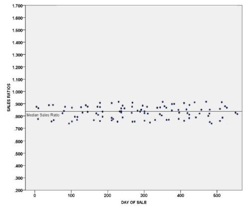
Considerable dispersion:
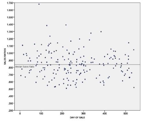
No dispersion:
Measures of dispersion or variability are either absolute or relative.
Absolute Measures
- Range
- Variance
- Standard Deviation
- Average Mean Absolute Deviation
- Average Median Absolute Deviation
Relative Measures
- Coefficient of Dispersion
- Coefficient of Variation
Absolute Measure
Median deviation is the average of the absolute deviations of the observations from their own median value. The absolute deviation is calculated by subtracting the median from the sales ratio. The resulting number will be treated as “absolute” or without a positive or negative sign.
Absolute value is defined as the value of a number regardless of its sign, e.g., the numbers (3) and (-3) both have an absolute value of 3.
Example:
| Parcel | Sales Ratio | - Median | = Absolute Deviation from Median |
|---|---|---|---|
| 1 | 1.0730 | 0.9574 | 0.1156 |
| 2 | 1.0648 | 0.9574 | 0.1074 |
| 3 | 0.9574 Median | 0.9574 | 0.0000 |
| 4 | 0.8977 | 0.9574 | 0.0597 |
| 5 | 0.8305 | 0.9574 | 0.1269 |
| 0.4096 |
Sum of absolute deviations from median / Number of observations = Average absolute deviation from the median
0.4096 ÷ 5 = 0.0819
Advantages and disadvantages:
The average absolute deviation from the median requires somewhat involved computation, but it uses all the data items, and it is a good measure of the typical dispersion among the items. It is not severely affected by an occasional very high or very low value among the observations.
Relative Measure
The coefficient of dispersion (COD) is a relative measure of dispersion. It measures the amount of dispersion among the observations in a set of data compared to a measure of central tendency for the same data set. The COD is a measure of dispersion widely used in assessment work. It is computed as follows:
(Average absolute deviation from the median ÷ Median sales ratio) × 100 = COD
It is the percentage by which the various individual sales ratios differ, on the average, from the median or mean ratio. The COD is the single most useful measure of assessment variability. Six steps are required to calculate the COD:
- Compute the difference between each sales ratio and the measure of central tendency. The measure of central tendency used by the assessor’s office is the median.
- Take the absolute value of the difference.
- Sum the absolute differences.
- Divide that sum by the number of observations (N) to obtain the average deviation.
- Divide the average deviation by the appropriate measure of central tendency (the median).
- Multiply that quotient by 100.
For assessment work, the usual method is the absolute deviation from the median divided by the median sales ratio. This is because the absolute deviation from the median is a stable measure of dispersion, and the median sales ratio is a stable measure of central tendency, especially when there are extreme data values.
Example:
| Parcel | Sales Ratio | - Median | = Absolute Deviation from Median |
|---|---|---|---|
| 1 | 1.0730 | 0.9574 | 0.1156 |
| 2 | 1.0648 | 0.9574 | 0.1074 |
| 3 | 0.9574 | 0.9574 | 0.0000 |
| 4 | 0.8977 | 0.9574 | 0.0597 |
| 5 | 0.8305 | 0.9574 | 0.1269 |
| 0.4096 |
0.4096 ÷ 5 = 0.0819 Average Absolute Deviation from the Median
Coefficient of Dispersion:
(Average absolute deviation from the median ÷ Median sales ratio) × 100 = COD
(0.0819 ÷ 0.9574) × 100 = 8.554 COD
Prorating Values
All property, real and personal, located in the state at 12:00 noon on January 1 is considered taxable unless expressly exempted by the Constitution or state statutes, § 39-1-105, C.R.S.
Statute requires all property in the state to be valued based on the condition and location of the property on January 1 of the assessment year. Certain exceptions to the rule require the assessor’s office to prorate values according to the period of time the property was legally taxable. The word “prorate” means to divide or distribute proportionately. Circumstances where proration/apportionment is required by law are:
- Real property that was destroyed after the assessment date, § 39-5-117, C.R.S.
- Real property that becomes exempt after the assessment date, §§ 39-3-124, 39-3-129, and 130(1)(a)(I), C.R.S.
- Exempt real property that becomes taxable after the assessment date, §§ 39-3-124, 39-3-129, and 130(1)(b)(I), C.R.S.
- Titled manufactured homes that enter or leave the state after the assessment date, §§ 39-5-204(1)(c)(II), and 205(3)(b), C.R.S.
- Manufactured homes located on sales display lots of manufactured home dealers and listed as inventories of merchandise by the dealer are exempt, § 39-5-203(3)(a), C.R.S. If the manufactured home becomes part of the dealer’s inventory and located on a display lot or is removed from the display lot to a taxable location, the value is prorated by the day, based on the date the home changed taxable status.
- The value of movable equipment and oil and gas rotary drilling rigs that enter or leave the county after the assessment date is apportioned between affected counties according to amount of time spent in each county, §§ 39-5-113 and 113.3, C.R.S.
- Works of art qualify for a property tax exemption when the works of art are in the custody and control of the state or a political subdivision thereof, a library or any art gallery or museum which is owned or operated by a charitable organization whose property is irrevocably dedicated to charitable purposes and whose assets shall not inure to the benefit of any private person. The exemption applies only for the period of time the works of art are actually on loan, §§ 39-1-102(18), 39-3-123, and 39-5-113.5, C.R.S.
General Proration Rules
Prorate the actual value to the exact number of days the real property was legally taxable, except when a titled manufactured home moves into and out of the state. In those circumstances, the assessed value is prorated using whole months.
- Determine the number of days the real property was legally taxable by adding together the number of days in each taxable month.
Hint: September, April, June, and November have 30 days. All the other months have 31 days except for February. February has 28 days except in a leap year, then it has 29 days.
- Determine the actual value per day by dividing the total actual value of the property by 365, or 366 for leap year. Round to the nearest cent.
- Determine the taxable actual value by multiplying the resulting proportion (dollars per day) by the number of taxable days. Round to the nearest dollar.
- Determine the prorated assessed value by multiplying the prorated taxable actual value by the appropriate assessment ratio. Round according to your county’s policy.
- Verify the calculations.
- It is essential to maintain a system to track records with prorated values so the appropriate changes can be made each January 1. See Chapter 3, Specific Assessment Procedures, for details.
Example:
A parcel of real property was taxable on January 1 and becomes exempt on June 1 of a non-leap year. The total actual valuation is $300,000, with $60,000 allocated to the land and $240,000 allocated to the building. The property will be classified as a charitable doctor’s office (9184/9284); however, the current subclassification codes are 2120/2220. Determine the prorated taxable value of the property.
FIRST: Determine the number of taxable and exempt days. The property is taxable from January 1 through May 31:
January ........... 31
February ......... 28
March ............. 31
April ............... 30
May ................ 31
151 Days
June 1 is not included because that is the day it became exempt.
SECOND: Determine the land and improvement actual value per day.
Land:
$60,000 Actual value ÷ 365 Days = $164.38 Per day (2120)
Improvement:
$240,000 Actual value ÷ 365 Days = $657.53 Per day (2220)
THIRD: Determine the prorated taxable and exempt actual values.
Land:
$164.38 Per day × 151 Taxable days = $24,821 Prorated taxable actual value (2120)
$164.38 Per day × 214 Exempt days = $35,177 + 2 Prorated exempt actual value (9184)
Improvement:
$657.53 Per day × 151 Taxable days = $99,287 Prorated taxable actual value (2220)
$657.53 Per day × 214 Exempt days = $140,711 + 2 Prorated exempt actual value (9284)
NOTE: The rounding adjustment is made to the time-frame with the greatest number of days.
FOURTH: Determine the prorated taxable and exempt assessed values.
Land:
$24,821 Prorated taxable actual value × 0.29 Assessment rate = $ 7,198 Assessed taxable value
$35,179 Prorated exempt actual value × 0.29 Assessment rate = $10,201 Assessed exempt value
Improvement:
$99,287 Prorated taxable actual value × 0.29 Assessment rate = $28,793 Assessed taxable value
$140,713 Prorated exempt actual value × 0.29 Assessment rate = $40,806 Assessed exempt value
Round the prorated taxable assessed value to the nearest $1.
FIFTH: There are many ways to verify the calculations. The following is one example:
Land:
$24,821 Taxable actual value (2120)
$35,179 Exempt actual value (9184)
$60,000
Improvement:
$99,287 Taxable actual value (2220)
$140,713 Exempt actual value (9284)
$240,000
A record reflecting four subclass codes for the property should appear on the assessment roll: a taxable land code, a taxable improvement code, an exempt land code and an exempt improvement code.
Destroyed or Demolished Property Proration Rule
The assessed value of a real property improvement that is demolished or destroyed is prorated from January 1 of the current year to the date of destruction. The date the property was destroyed is not counted as a taxable day.
The property owner has the responsibility of reporting the real property as destroyed and the date of the occurrence. A demolition permit may serve as notification of destruction. If the destruction or demolition is not reported, the assessor is not required to prorate the value in accordance with § 39-5-117, C.R.S. If the destruction is well publicized, the assessor may wish to initiate a re-inspection of the property or properties involved in the interest of public relations. Statute does not authorize the proration of value for damaged property.
Property improvements destroyed after assessment date.
Whenever any improvements are destroyed or demolished subsequent to the assessment date in any year, it is the duty of the owner thereof or the owner’s agent to promptly notify the assessor of such destruction or demolition and the date upon which the same occurred. In all such cases, such improvements shall be valued by the assessor at the proportion of its valuation for the full calendar year that the period of time in such year prior to its destruction or demolition bears to the full calendar year. Failure of the owner thereof or of the owner’s agent to so notify the assessor prior to the date taxes are levied shall be considered a waiver, and no proportionate valuation by the assessor shall then be required.
§ 39-5-117, C.R.S.
Reclassifying the land associated with a destroyed improvement:
If the improvement is entirely destroyed the assessor must determine how to classify the underlying land on the following assessment date. Non-residential land should be classified as vacant lots, with abstract codes 0200, 0300, or 0400, according to zoning and permitted uses. However, as provided in § 39-1-102(14.4)(b), C.R.S., if the improvement is residential and destroyed by a “natural cause,” the residential land classification shall remain in place for the year of destruction and the two subsequent property tax years. The residential classification may remain in place for additional subsequent property tax years if the assessor determines there is evidence the owner intends to rebuild or locate a residential improvement on the land.
Additionally, if a residential improvement is destroyed, demolished, or relocated after January 1, 2018, § 39-1-102(14.4)(c)(I), C.R.S., allows the residential land classification to stay in place for the year in which the improvements were destroyed, demolished or relocated and one subsequent property tax year as long as the assessor is able to determine that there is evidence that the owner intends to rebuild or locate a residential improvement on the property. The same proration rules apply to these types of residential improvements that are destroyed, demolished or relocated. These improvements, however, do not qualify for the reimbursement from the state of Colorado as they were not destroyed by natural causes.
When calculating prorated values for destroyed or demolished real property, the most important thing to remember is to prorate only the improvement value. Separate the land value from the improvement value, prorate the improvement value to the date of destruction, then add the land back to the prorated improvement value to arrive at the total taxable value for the property.
Example: Real Property Destroyed or Demolished
A commercial property has an actual value of $575,860, with $100,000 allocated to land and $475,860 allocated to improvements. The building was completely destroyed by explosion and fire on March 12 of the current year. The owner notified the assessor prior to the date taxes were levied. Determine the prorated value of the property.
First: Determine the number of taxable days; do not count the day of destruction. The property is taxable from January 1 through March 11.
January ...........31
February .........28
March .............11
70 Days
Second: Determine the actual value per day for the improvement. The land value is not prorated.
$475,860 Improvement actual value ÷ 365 Days = $1,303.73 Per day
Third: Determine the prorated taxable actual value of the improvement.
$1,303.73 Per day × 70 Taxable days = $91,261 Prorated taxable improvement actual value
Fourth: Determine the prorated taxable assessed value of the improvement.
$91,261 Prorated taxable improvement actual value × 0.29 Assessment rate = $26,465.69
$26,465.69 Rounded to the nearest $1 = $26,466 Improvement assessed value
Fifth: Verify the calculations:
$475,860 Actual value imp. × 0.29 Assessment rate = $138,000 Assessed value
$138,000 Assessed value ÷ 365 Days = $378.08 Assessed value per day
$378.08 Assessed value per day × 70 Taxable days = $26,466 Taxable assessed value
365 Days - 70 Taxable days = 295 Non-Taxable days
$378.08 Per day × 295 Non-taxable day = $111,534 Non-taxable assessed value
$111,534 Non-taxable assessed value + $26,466 Taxable assessed value = $138,000
A record reflecting the full land value and the prorated improvement value should appear on the assessment roll.
Tax Calculation:
Determine the amount of the tax bill the owner will receive in January assuming a tax rate of 0.043270 (43.270 mills.)
Determine the total taxable assessed value of the property by adding the assessed value of the land to the prorated assessed value of the improvements.
$100,000 Actual value land × 0.29 Assessment rate = $29,000 Assessed value
$ 91,261 Actual value improvement × 0.29 Assessment rate = $26,466 Assessed value
$55,466 Total assessed value
Multiply the total assessed value by the tax rate to determine the taxes due.
$55,466 Total assessed value × 0.043270 Tax rate = $2,400 Tax
Property Taxes Reimbursed by the State on Destroyed Property – Report to Treasurer
In 2014, the legislature passed HB 14-1001 that created § 39-1-123, C.R.S. This provides for a reimbursement of property taxes to a property owner whose real and/or business personal property was destroyed by a natural cause.
Definitions.
(8.4) “Natural cause” means fire, explosion, flood, tornado, action of the elements, act of war or terror, or similar cause beyond the control of and not caused by the party holding title to the property destroyed.
§ 39-1-102, C.R.S.
The value removed from the tax roll due to real property proration is NOT reimbursed by the state through this process. Only the assessed value of the destroyed improvement(s) that remains on the tax roll in the year of the event is reported. Except in rare circumstances as detailed below, the assessed value of the land and site improvements are not reported. In the case of business personal property, the entire value of the qualifying account is reported.
In the case of real property improvements with multiple buildings, there may be certain buildings that are totally destroyed while others are only damaged or not affected. In such cases, the appraiser should make note of the status of each building so the value of destroyed improvements can be prorated to the date of the event and the remaining value of those destroyed improvements tracked for this report. The land value is not prorated or included in the report, neither are the assessed values of any damaged or unaffected improvements.
If there are no buildings, but site improvements such as septic system, utility or sewer lines/hookups, well or water system which are totally destroyed, any contributory value of these site improvements should be tracked as reimbursable for the report to the county treasurer. However, the value is NOT prorated for the year of the event.
If the event causes the entire legally described parcel to lose all value, the total value of the land should be tracked for the reimbursement report. The value is NOT prorated for the year of the event.
An example of such “destroyed land” would be if the streambed was permanently changed so that the entire legal description was under water. There would have to be a presumption that the cost to reclaim the parcel would not be financially feasible or not allowed by a federal or state authority.
For business personal property, the property must be totally destroyed, and be reported on a single schedule to qualify for reimbursement. The personal property can be owned or leased, but if the owner or lessor owns/leases other property in the county that is also reported on the same schedule, there is no qualifying value for reimbursement. This provision effectively prevents any personal property of a state assessed company from qualifying. The total value of the qualifying personal property account should be tracked for the report to the county treasurer, but no proration is made for the year of the event.
An example of qualifying destroyed personal property would be: a flood or tornado destroyed/damaged a grocery store building so that all the shelving, office equipment and furniture, cash registers, and grocery carts were completely destroyed, AND all this was listed on the owner’s personal property schedule. If ANY of the personal property listed was merely damaged or not affected, there is not any value qualifying as reimbursable.
On or before December 15, the assessor will forward to the county treasurer a report of the property that was destroyed by a natural cause through November of that year. Be careful that property destroyed/demolished due to non-reimbursable causes is not included (intentionally torn down or demolished; destroyed by property owner; or removed for any reason other than a natural cause.) These properties still qualify for proration, but are not reimbursable under this statute. The reimbursable report must include the following information:
For real property (includes site improvements and land, if applicable):
- Legal description of each parcel
- Schedule or parcel number
- Name of owner
- Description of destroyed property
- Date of destruction
- The prorated property taxes due on the property
For taxable business personal property:
- Schedule or identifying number
- Name of the owner or lessor and business name if applicable
- Property taxes due (no proration)
If, after submitting the December report to the county treasurer, the assessor discovers additional real or personal property that was destroyed by the natural cause; the assessor shall forward to the treasurer a supplemental report by July 1 of the next tax year (October 1 for public utility property).
Property Changing Taxable Status
A change in tax status occurs when a governmental entity buys or sells property, or when the Administrator issues a determination granting exemption, a forfeiture, or a revocation. A change in tax status also occurs when real property is used for governmental purposes and is leased or rented, for at least a one-year term, to the state, a political subdivision, or a state-supported institution of higher education, § 39-3-124(1)(b)(I)(A).
If an exempt property becomes taxable or a taxable property becomes exempt for a portion of the assessment year, general proration rules are used to determine the number of taxable days, the actual value per day, the prorated actual value, and the prorated assessed valuation. As illustrated previously, this is accomplished by determining the number of taxable days, multiplying the number of taxable days by the actual value per day, and then multiplying by the appropriate assessment ratio.
Exemption Proration Rules
First: Determine the number of days the real property was legally taxable by adding together the number of days in each month.
Note: The date the exemption was granted is not taxable. The date the exemption was lost is taxable.
Exemption for governmental entities is determined by the delivery date of the deed; the property is exempt for the number of days the exempt entity held title. Refer to Title Conveyance, Chapter 3, Specific Assessment Procedures, for additional information on deed priority dates.
Priority of deed dates:
- Date of delivery; date title passes to the grantee (shown in the signature area of the deed).
- Acknowledgment date; date deed signed by grantor and acknowledged by a notary public.
- Date made; date deed was prepared.
- Recording date; date deed was recorded by the clerk and recorder.
Second: Divide the actual value of the land and improvement by 365 days (366 for leap year) to find the value per day for each.
Third: Multiply the value per day by the number of taxable days. Multiply the value per day by the number of exempt days.
Fourth: If a determination involves a percentage of the property, a double calculation is required. The number of days the property was 100 percent taxable must be multiplied by the value per day. This total is then added to the total value for the number of days exempt, multiplied by the value per day, and then multiplied by the percent taxable. See Example 2.
Fifth: Sum the taxable value and the exempt values to verify they equal the full actual value. See Example 1.
A record reflecting four subclass codes for the property should appear on the assessment roll; a taxable land code, a taxable improvement code, an exempt land code and an exempt improvement code.
Example 1:
Owner A was granted exemption effective April 15 of the current year. The total property actual value is $99,460, with $24,000 allocated to the land and $75,460 allocated to the building.
First: Determine the number of taxable and exempt days.
January .............31
February ...........28
March ...............31
April .................14
104 Taxable days
April ................ 16
May ................. 31
June ................. 30
July .................. 31
August ............. 31
September ....... 30
October ............ 31
November ........ 30
December ........ 31
261 Exempt days
Second: Determine the land and improvement actual values per day.
Land:
$24,000 Actual value ÷ 365 Days = $65.75 Per day
Improvement: $75,460 Actual value ÷ 365 Days = $206.74 Per day
Third: Determine the taxable actual value and exempt actual value.
Land:
$65.75 Per day × 104 Taxable days = $6,838 Taxable actual value
$65.75 Per day × 261 Exempt days = $17,160.75 ($17,161) Exempt actual value
Improvement:
$206.74 Per day × 104 Taxable days = $21,500.96 ($21,501) Taxable actual value
$206.74 Per day × 261 Exempt days = $53,959.14 ($53,959) Exempt actual value
Fourth: The exemption involves 100 percent of the property; thus, this step is unnecessary.
Fifth: Sum the taxable and exempt values to verify they equal the full actual value.
$ 6,838 Taxable actual value
$17,161 (+1) Taxable actual value
$24,000
$21,501 Taxable actual value
$53,959 Exempt actual value
$75,460
Note: $1 was added to the taxable land value because it is the largest of the land values.
Example 2:
Owner B lost exemption on 64 percent of the real property effective November 11 of the current year. The total property actual value is $230,877 with $55,410 allocated to the land and $175,467 allocated to the building.
Note: The property is 100 percent exempt from January 1 thru November 10 and 64 percent taxable from November 11 to December 31.
First: Determine the number of taxable and exempt days.
January ................. 31
February ............... 28
March ................... 31
April ..................... 30
May ...................... 31
June ...................... 30
July ....................... 31
August .................. 31
September ............ 30
October ................. 31
November ............. 10
314 Exempt days
November ......... 20
December .......... 31
51 Partially taxable days
Second: Determine the land and improvement actual values per day.
Land:
$55,410 Actual value ÷ 365 Days = $151.81 Per day
Improvement:
$175,467 Actual value ÷ 365 Days = $480.73 Per day
Third: Determine the taxable actual value and exempt actual value.
Land:
$151.81 Per day × 51 Partially taxable days = $7,742 Partially taxable actual value
$151.81 Per day × 314 Exempt days = $47,668 Exempt actual value
Improvement:
$480.73 Per day × 51 Partially taxable days = $24,517 Partially taxable actual value
$480.73 Per day × 314 Exempt days = $150,949 Exempt actual value
Fourth: Determine the taxable and exempt value for the partially exempt period of time.
Land:
$7,742 Partially taxable actual value × 64% = $4,955 Taxable actual value for 51 days
$7,742 Partially taxable actual value × 36% = $2,787 Exempt actual value for 51 days
Improvement:
$24,517 Partially taxable actual value × 64% = $15,691 Taxable actual value for 51 days
$24,517 Partially taxable actual value × 36% = $8,826 Exempt actual value for 51 days
Fifth: Sum the taxable and exempt values to verify they equal the full actual value.
Land:
$47,668 Exempt actual value for 314 days
$ 4,955 Taxable actual value for 51 days
$ 2,787 Exempt actual value for 51 days
$55,410
Improvement:
$150,949 (+1) Exempt actual value for 314 days
$ 15,691 Taxable actual value for 51 days
$ 8,826 Exempt actual value for 51 days
$175,467
Note: $1 was added to the exempt improvement value because it is the largest of the improvement values.
Example 3:
Non-residential land and improvements of a previously exempt organization are sold to a non-qualifying organization on August 1. The total actual value of the property is $495,000, with $118,800 allocated to the land and $376,200 allocated to the building. Determine the prorated taxable assessed value.
First: Determine the number of taxable and exempt days.
August 31
September 30
October 31
November 30
December 31
153 Days
Second: Determine the land and improvement actual values per day.
Land:
$118,800 Actual value ÷ 365 Days = $325.48 Per day
Improvement:
$376,200 Actual value ÷ 365 Days = $1,030.68 Per day
Third: Determine the taxable actual value and exempt actual value.
Land:
$325.48 Per day × 153 Taxable days = $49,798 Taxable actual value
$325.48 Per day × 212 Exempt days = $69,002 Taxable actual value
Improvement:
$1,030.68 Per day × 153 Taxable days = $157,694 Taxable actual value
$1,030.68 Per day × 212 Exempt days = $218,504 Exempt actual value
Fourth: The exemption involves 100 percent of the property; thus, this step is unnecessary.
Fifth: Sum the taxable and exempt values to verify they equal the full actual value.
Land:
$ 49,798 Taxable actual value
$ 69,002 Exempt actual value
$118,800
Improvement:
$157,694 Taxable actual value
$218,504 (+2) Exempt actual value
$376,200
Note: $2 was added to the exempt value because it is the largest value.
Rotary Drilling Rig/Portable Equip. Apportionment
Rotary oil and gas drilling rigs, also called rotary rigs, and movable and portable equipment are personal property. They are subject to special apportionment rules. The actual value of a drilling rig, or the movable or portable equipment is divided among the counties where the property was located the previous year.
Owners of movable or portable equipment are required to file a statement accompanying the personal property declaration schedule indicating the counties in which the property is apt to be located during the assessment year, § 39-5-113, C.R.S. The county assessor then apportions the value based on the proposed location(s) during the year and notifies the owner and the other county assessors of the value and apportionment. If an assessor discovers that property was located in his or her county for a period of time that is different from the original apportionment, the county assessor discovering the error must request an amended apportionment. Failure to request an amended apportionment shall permit the original apportionment to stand, § 39-5-113(3), C.R.S.
Each year not later than April 15, rig owners are required to submit a rig location log for each rig they operated during the previous year. They submit the logs to the county of original assessment, that is, the county where the rig was first located during the previous year. This procedure is pursuant to § 39-5-113.3, C.R.S.
Apportionment occurs after the actual value of a rig has been determined by the county of original assessment. The actual value is divided by 365 to determine the actual value per day (366 for leap years). The actual value per day is then multiplied by the number of days the rig was located in each county to determine the apportioned value.
The county of original assessment notifies each Colorado county of its apportionment of the rig’s actual value and sends a copy of the log and apportionment. The company is notified in the same way. Both notifications must occur on or before June 15, § 39-5-113.3, C.R.S. Sections 39-5-121(1.5) and (1.7), C.R.S., requires that notices of value be sent to owners of personal property or upon the taxpayers request, the NOV may be sent electronically; therefore, the county of original assessment is responsible for mailing the Notice of Valuation to the rig owner. The notice should state the total value of the rig. Notices of Valuation may be mailed by the counties receiving an apportioned value, but this is purely optional. If the rig owner wishes to file a protest on the rig value assigned by the assessor, the owner must file a protest with the county of original assessment.
Travel days are assigned to the destination county. Stacked rig days are assigned to the county in which the rig was stacked. Final actual value rounding errors, either plus or minus, are assigned to the county of original assessment.
If assessor errors are found after the original apportionment but before August 1, the county of original assessment may submit a revised apportionment to the owner and other counties involved. Operator errors can only be corrected by the county of original assessment and only prior to August 10. After August 10, no changes can be made due to the August 25 Abstract of Assessment deadline.
Example: Rig Apportionment
The rig operator submits the following log to the county of original assessment. The assessor determines the actual value of the rig to be $750,000. Determine the apportioned actual value that should be assigned to each county.
First: Determine the number of taxable days attributable to each county. Calculate the number of days for each well.
| Well Name | County | Date-From | To | #Days |
|---|---|---|---|---|
| Idler #2 | Prowers, CO | 01-01 | 01-23 | 23 |
| Twombly #1-12 | Cimmaron, OK | 01-24 | 02-09 | 17 |
| Robbins Ranch “A” #1 | Baca, CO | 02-10 | 03-18 | 37 |
| Idler “F” #1 | Prowers, CO | 03-19 | 05-01 | 44 |
| Pinkard #1 | Baca, CO | 05-02 | 06-28 | 58 |
| Hoffman-Federal #1 | Prowers, CO | 06-29 | 07-28 | 30 |
| Buxton #1 | Bent, CO | 07-29 | 08-08 | 11 |
| Hinrich #1 | Wallace, KS | 08-09 | 08-28 | 20 |
| Bailey Farms,Inc. #4 | Prowers, CO | 08-29 | 10-19 | 52 |
| Hudson-Persyn #1 | Bent, CO | 10-20 | 11-02 | 14 |
| Negley “A” #1 | Kiowa, CO | 11-03 | 12-03 | 31 |
| Hefley #2 | Baca, CO | 12-04 | 12-31 | 28 |
| Total | 365 |
Second: Determine the actual value per day.
$750,000 Actual value ÷ 365 Days = $2,054.79 Per day
Third: Determine the apportioned taxable actual value attributable to each county.
| Days × $2,054.79 | Actual Value | |
|---|---|---|
| Days in Baca County, CO | 123 × $2,054.79 | $252,739 |
| Days in Bent County, CO | 25 × $2,054.79 | 51,370 |
| Days in Kiowa County, CO | 31 × $2,054.79 | 63,698 |
| Days in Prowers County, CO | 149 × $2,054.79 | 306,164 + 2 |
| Days in Wallace County, KS | 20 × $2,054.79 | 41,096 |
| Days in Cimmaron County, OK | 17 × $2,054.79 | 34,931 |
| Total | $750,000 |
Note: $2 was added to Prowers County to account for the rounding error because it is the county of original assessment.
Manufactured Homes
Titled manufactured homes are prorated by month when the owner notifies the assessor that the home will be moved out of state or a manufactured home moves into the county from out of state, §§ 39-5-204(1)(c)(II) and 205(3)(b), C.R.S. The value is not prorated if a titled manufactured home is moved to another county in the state or when the home is moved within the county. Upon notification to the treasurer, the taxes become due and payable for the full calendar year to the county in which it was located on January 1, if the home is removed from the county, § 39-5-205(3)(a), C.R.S.
A fraction of any month is counted as a full month if the titled manufactured home leaves the state on or after the 16th. The assessed value of the titled manufactured home is divided by 12 to determine the assessed value per month. The assessed value per month is then multiplied by the number of taxable months to arrive at a prorated assessed value. The prorated assessed value is then multiplied by the tax rate (previous year if tax rate has not been set) to determine taxes dues.
Example: Manufactured Home Out-of-State Move
A titled manufactured home, which was in the county on the assessment date, has an assessed value of $5,020. The home is permitted to move out of state on May 15. The tax rate is 0.103680. Determine the prorated tax.
First: Determine the number of taxable months. The home is taxable from January through April. May is not counted because the home was not in the county on or after the 16th.
January + February + March + April = 4 Months
Second: Determine the taxable assessed value per month. Round to the nearest cent.
$5,020 Total assessed value ÷ 12 Months = $418.33 Per month
Third: Determine the prorated taxable assessed value. Round to the nearest dollar.
$418.33 Per month × 4 Months = $1,673 Taxable assessed value
Fourth: Multiply the prorated taxable assessed value by the tax rate to determine the taxes due prior to movement of the titled manufactured home.
$1,670 Taxable assessed value × 0.103680 Tax rate = $173.15 Tax
Example: Titled Manufactured Home In-State Move
A titled manufactured home was delivered to Cheerful Manufactured Home Park in Shine County, Colorado on May 17 from Nebraska. The titled manufactured home has an assessed value of $3,264. The tax rate is 0.081432. Determine the prorated tax.
First: Determine the number of taxable months. The home is taxable from June through December. May is not counted because the home was not in the county prior to the 16th.
June + July + August + September + October + November + December = 7 Months
Second: Determine the taxable assessed value per month. Round to the nearest cent.
$3,264 Total assessed value ÷ 12 Months = $272.00 Per month
Third: Determine the prorated taxable assessed value. Round to the nearest dollar.
$272.00 Per month × 7 Months = $1,904 Taxable assessed value
Fourth: Multiply the prorated taxable assessed value by the tax rate to determine the taxes due prior to movement of the titled manufactured home.
$1,904 Taxable assessed value × 0.081432 Tax rate = $155.05 Tax
Titled manufactured homes which are located on sales display lots of manufactured home dealers and listed as inventories of merchandise by the dealer are exempt, § 39-5-203(3)(a), C.R.S. If the manufactured home becomes part of the dealer’s inventory and located on a display lot, the value is prorated by the day, based on the date the home changed taxable status.
New or used manufactured homes taken in trade or purchased by dealers and which remain on locations other than the dealer’s sales display lot are taxable.
Note: If the manufactured home remains in dealer inventory, the dealer is not required to obtain a new Certificate of Title, § 38-29-115, C.R.S.
Example: Manufactured home traded in on new manufactured home
A used titled manufactured home is traded in on a new titled manufactured home. The ownership of the used home is transferred to the dealer, moved to the dealer’s sales display lot, and listed as inventory August 1. The ownership change of the new titled manufactured home is also effective August 1. The actual value of the used home is $10,500. The new home as an actual value of $102,500. Calculate the prorated taxable value for each home.
First: Determine the number of taxable and exempt days.
The used home is taxable from January 1 through July 31:
January 31
February 28
March 31
April 30
May 31
June 30
July 31
212 Days
The new home is taxable from August 1 through December:
August 31
September 30
October 31
November 30
December 31
153 Days
Second: Determine the used and new home actual value per day.
Used home:
$10,500 Actual value ÷ 365 Days = $28.77 Per day (1235)
New home:
$102,500 Actual value ÷ 365 Days = $280.82 Per day (1235)
Third: Determine the prorated taxable and exempt actual values.
Used home:
$28.77 Per day × 212 Taxable days = $6,099 – $1 Prorated taxable actual value (1235)
$28.77 Per day × 153 Exempt days = $4,402 Prorated exempt actual value (1235)
New home:
$280.82 Per day × 153 Taxable days = $42,965 Prorated taxable actual value (1235)
$280.82 Per day × 212 Exempt days = $59,534 + 1 Prorated exempt actual value (1235)
Note: The rounding adjustment is made to the time-frame with the greatest number of days.
Fourth: Determine the prorated taxable and exempt assessed values.
Used home:
$6,098 Prorated taxable actual value × TBD Assessment rate = $TBD Assessed taxable value
$4,402 Prorated exempt actual value × TBD Assessment rate = $TBD Assessed exempt value
New home:
$42,965 Prorated taxable actual value × TBD Assessment rate = $TBD Assessed taxable value
$59,535 Prorated exempt actual value × TBD Assessment rate = $TBD Assessed exempt value
Round the prorated taxable assessed value to the nearest $1.
Fifth: There are many ways to verify the calculations. The following is one example:
Used home:
$ 6,098 Taxable actual value (1235)
$ 4,402 Exempt actual value (1235)
$10,500
New home:
$ 42,965 Taxable actual value (1235)
$ 59,535 Exempt actual value (1235)
$102,500
Notice
A property owner must be sent a Notice of Valuation (NOV) every year regardless of whether or not the value has changed, § 20(8)(c), art. X, COLO. CONST. Statute requires that a protest form accompany the NOV, §§ 39-5-121(1) and (1.5), C.R.S. The notice must be mailed no later than May 1. In an intervening year (even-numbered years), the assessor may include the NOV with the tax bill, provided the notice meets the criteria set forth in § 39-5-121(1.2), C.R.S. With the passage of HB 10-1117, a taxpayer may also request the Notices of Valuation by electronic transmission, § 39-5-121(1.7), C.R.S. The required language for the NOV and other forms used in the appeals process are identified in Chapter 9, Form Standards.
Taxpayer’s Responsibilities
Filing a Protest
If a taxpayer disagrees with the value assigned by the assessor, the taxpayer may file a protest during the statutory protest period. Real property protests must be postmarked or taxpayers must appear in person to protest no later than June 8, § 39-5-121(1)(a), C.R.S. Personal property protests must be postmarked or physically delivered no later than June 30. A protest form is included with the Notice of Valuation; however, it is not mandatory that the taxpayer use this form, or any other particular form, when protesting.
All Colorado counties have an option to elect to alter the protest process for real and personal property by expanding the assessor’s time to answer protests from the last regular working day in June to August 15. This gives the assessors additional time in which to answer protests. The alternate protest process must be requested by the assessor and approved by the board of county commissioners, who shall notify the Board of Assessment Appeals (BAA) and district court, § 39-5-122.7(1), C.R.S.
If the protested property is rent producing commercial real property, and the county has elected to follow the alternate appeals process, the taxpayer shall submit to the assessor no later than July 15 the following information:
Two full years including the base year for the relevant property tax year:
- actual annual rental income
- tenant reimbursements
- itemized expenses
- rent roll data as of the valuation date, including the name of any tenants, the address, unit, or suite number of the subject property, lease start and end dates, option terms, base rent, square footage leased, and vacant space; for two years including the year of valuation date and the prior year.
A taxpayer may protest the total value of the property, not individual components. See H.R. Cherne et al. v. Boulder County Board of Equalization, 885 P.2d 258 (Colo. App. 1994).
Filing Requirements
The United States Postal Service is the primary means of delivery of most documents. As such, the postmark is the qualifier as to whether the document has been considered timely filed with the assessor. The law provides that the document is considered to be received on the date it is postmarked, §§ 39-1-120(1) and (2), C.R.S.
If either the form initiating a protest or a written objection to the valuation of property is hand-delivered, the assessor must date stamp the protest because the protest will be presumed to be timely filed unless the assessor can present evidence to show otherwise, § 39-5-122(2), C.R.S.
Any taxpayer filing deadline that falls on a Saturday, Sunday, or legal holiday, shall be deemed to be timely filed if filed on the next business day, § 39-1-120(3), C.R.S.
Standing
Property owners are the parties given statutory authority to protest an assessor’s valuation or classification of their property. However, an owner may expressly designate others to pursue a property tax appeal on their behalf. Protests may be filed by an agent of a property owner when the agent has proper authority from the owner to represent the owner in their protest. The Division recommends that assessors require written authorization of agency from persons who are not the owner of record but are filing a protest on behalf of the owner. The title of the document containing this express authority is not important. Regardless of agency authority granted to others, the owner remains liable for payment of the property taxes. Legal considerations associated with agency and assignment differ. For questions concerning this difference or other issues, it is recommended that the assessor consult with the county attorney.
Assessor’s Responsibilities
After the passage of the 1982 Amendment One to the Colorado Constitution, there were many complaints to legislators regarding the treatment that taxpayers were receiving in their county offices. In the 1988 Legislative Session the following legislating declaration regarding taxpayer rights was passed into law:
Legislative declaration – taxpayer rights.
The general assembly hereby finds and declares that section 3 of article X of the state constitution was approved in 1982 by the voters of Colorado in order to ensure the fair and uniform valuation for assessment of real and personal property located in Colorado; that, since the adoption of said constitutional amendment, the property tax system in Colorado has developed into an impersonal system which is more concerned with the mechanisms to levy and collect such tax than with the fair and courteous treatment of the owners of real and personal property who pay such tax; that the purpose of the property tax system is to raise revenues to be used for purposes which benefit the citizens of Colorado, including such property owners; that property owners accept their civic responsibility to pay their fair share of taxes to be used for such purposes; that all levels of government involved in the property tax system should recognize that they exist to serve their citizens; and that the owners of real and personal property should be accorded the respect and courtesy which they deserve and should be provided such services which are necessary to assist them in complying with the property tax laws of this state.
§ 39-1-101.5, C.R.S.
This is a strong mandate that the county officials not adopt policies and procedures that impede the property owners’ access to their due process, or discourage them from exercising their full rights as granted by the Colorado Constitution. Further, that the property owners should be treated with respect and courtesy and assisted in every way possible to comply with the property tax laws of the state. This includes:
- providing accurate information and clear instructions on filing all levels of protests and appeals;
- providing sufficient notice for all hearings and proceedings;
- making no distinction between property owners who live within the county and those who do not; and
- making no distinction between property owners who represent themselves versus those who choose to engage an attorney or an agent.
All personal inquiries and letters received by the assessor regarding property valuations during the protest period are logged and date stamped because all protests are considered timely filed unless the assessor can show evidence to the contrary, § 39-5-122(2), C.R.S. As a part of good office policy, the assessor should consider logging telephone calls and filing a copy of the telephone contact in the property record file. Inquiries that require follow-up but are not considered by the assessor to be formal protests, should be answered by letter. Inquiries considered to be formal protests must be answered with a Notice of Determination, § 39-5-122(2), C.R.S. These procedures will help alleviate future questions regarding the nature and content of the conversation with the taxpayer.
The assessor should establish office procedures regarding facsimile correspondence and on-line filings. The Division recommends that the assessor consult the county attorney or district attorney on this issue. Each assessor needs to provide staff with written guidelines as to how to handle these types of protests.
Within seven working days, at the written request of the taxpayer, the assessor must make available the data used to determine the actual value of the taxpayer’s property, § 39-5-121.5, C.R.S.
The assessor must send two copies of the Notice of Determination form to the person presenting the objection on or before the last regular working day in June for real property or by July 10 for personal property, § 39-5-122(2), C.R.S.
For those counties using the alternate protest process, the assessor has until August 15 to mail Notices of Determination for both real and personal property.
In each determination, the assessor includes the reason(s) for denial and information regarding the taxpayer’s right of appeal to the county board of equalization, § 39-8-106, C.R.S. The presumption of correctness of the assessor’s values, as has existed in the past, was eliminated by § 20, art. X, COLO. CONST. As such, assessors must be prepared to provide sound evidence in all appeal hearings. Likewise, the taxpayer’s burden of proof requires a taxpayer to demonstrate that an assessment is incorrect, Board of Assessment Appeals v. Sampson, 105 P.3d 198 (Colo. 2005). Additional statutory requirements for information to be included in the Notice of Determination can be found in Chapter 9, Form Standards.
The assessor shall correct erroneous or improper valuations, § 39-5-122(2), C.R.S. When a protest is filed, adjustments that raise or lower the valuation may be made during protest period. By filing a protest, the taxpayer opens the door to all corrections, San Miguel County Board of Equalization et al. v. Telluride, 947 P.2d 1381 (Colo. 1997). The taxpayer, as a matter of due process, always has the right to continue the appeal process until remedies are exhausted.
Due Process
If the assessor fails or refuses to hear a protester, the taxpayer may appeal directly to the county board of equalization, § 39-8-106(3), C.R.S.
County Board of Equalization
In every county except the City and County of Denver and the City and County of Broomfield, the board of county commissioners sits as the county board of equalization (county board) from July 1 until August 5 each year until all hearings are concluded and decisions rendered, § 39-8-107(2), C.R.S. Counties have the option of using an alternate protest period. When the alternate protest period is used, the county board sits from September 1 until November 1, §§ 39-8-104(2) and 107(2), C.R.S.
The county board also hears individual taxpayers’ appeals of the assessor’s decisions. In order for the taxpayers to preserve their right of appeal, the appeal must be postmarked or delivered on or before July 15 for real property, and July 20 for personal property. The deadline for counties using the alternate protest period is September 15 for real and personal property, § 39-8-106(1)(a), C.R.S. If a taxpayer deadline falls on a Saturday, Sunday, or legal holiday, the document shall be deemed to have been timely filed if filed or postmarked on the next business day, § 39-1-120(3), C.R.S.
In addition, the county board reviews the valuations for assessment of all taxable property appearing in the assessment roll of the county, directing the assessor to supply any omissions which may come to its attention. Section 39-8-102(1), C.R.S., also directs the county board to correct any errors made by the assessor. Whenever appropriate, the board is allowed to raise, lower, or adjust any valuation for assessment appearing in the assessment roll to ensure that all valuations for assessment of property are just and equalized within the county.
If the county board determines that an adjustment is warranted, the county board issues a resolution to effect the change and a county board of equalization decision letter is mailed to the taxpayer explaining the reason for the adjustment and the taxpayer’s appeal rights. If errors are discovered by the assessor during the county board’s appeal period that impact the valuation of a class or subclass of property, the assessor shall recommend an adjustment to correct the error.
When circumstances arise that may require the county board to sit outside the statutory timeframe, the Division recommends that the commissioners discuss the situation with the county attorney and review Wenner v. Board of Assessment Appeals, 866 P.2d 172 (Colo. 1993).
At a meeting of the county board of equalization on or before each September 15 in a county using the alternate protest period pursuant to section § 39-5-122.7(1) and (4),C.R.S., or on or before each July 15 in all other counties, the assessor reports the valuation for assessment of all taxable real property in the county, submits a list of all persons who have protested valuations of real property, and reports the assessor’s action in each case, § 39-8-105(1), C.R.S.
At the meeting of the county board described above, the assessor reports the valuation of all taxable personal property in the county. The report includes the valuation for assessment of all portable or movable equipment which has been apportioned to the county pursuant to § 39-5-113, C.R.S. The assessor submits a listing of those persons in the county who have failed to return any declaration schedules and the action for each case. The assessor also submits a list of all persons who have protested valuations of personal property and the action taken, § 39-8-105(2), C.R.S.
The taxpayer may appear before the county board in person or may be represented by an authorized representative. If desired, the taxpayer may choose not to be present and simply provide written documentation to the county board, Isbill Associates Inc. v. Jefferson County Board of County Commissioners, 894 P.2d 52 (Colo. App. 1995). The assessor, or a representative of the assessor, must be present at the hearing and present evidence to support the basis and amount of the valuation, § 39-8-107(1), C.R.S.
At the written request of any taxpayer or taxpayer’s agent, the assessor must make available the data used in determining the actual value of any property owned by the taxpayer within three (3) working days following the written request. Upon receiving the request, the assessor must immediately advise the taxpayer or agent of the estimated cost of providing the data. The intent of the statute is that the assessor immediately estimates the cost because payment must be sent to the assessor prior to providing the data. Once the data is gathered, the assessor can choose whether the data is mailed, faxed, or sent by electronic transmission to the taxpayer or agent. No transmission fee may be charged for records sent via electronic mail. If the estimated cost was lower than actual costs, the assessor may include a bill with the data for any reasonable cost above the estimated cost subject to the statutory maximum. The additional costs are due and payable upon receipt of the data, § 39-8-107(3), C.R.S.
Section 24-72-205, C.R.S., was amended in 2014 with the addition of paragraph (6), which delineates how the charges may be calculated; a custodian may now impose a fee when responding to a request for the research and retrieval of public records if they have a written policy in place regarding charges. The policy must have been published or made available on the custodian’s website prior to receiving the request for information.
The statute does not allow the custodian to charge for the first hour of time expended in connection with the research and retrieval of public records. However, after the first hour, the custodian may charge a fee for the research and retrieval of public records. The fee may not exceed thirty-three dollars and fifty-eight cents per hour. This hourly rate will remain in effect until July 1, 2024, when the Director of Research of the Legislative Council adjusts the maximum hourly fee. This adjustment will occur every five years in accordance with the percentage change over the period in the United States Department of Labor, Bureau of Labor Statistics, Consumer Price Index for Denver-Aurora-Lakewood, all items, all urban consumers, or its successor index, § 24-72-205(6), C.R.S.
The assessor is to produce information, including the primary method and rates used to support the basis and amount of the assigned value. The assessor may not rely on any confidential data during the hearing which is not available for review by the taxpayer, unless the data is presented in such a manner that the source cannot be identified, § 39-8-107(3) and (4), C.R.S. The county board is required to consider all testimony and exhibits, § 39-8-107(1), C.R.S.
The county board shall grant or deny the petition, in whole or in part, and shall notify the petitioner in writing within five (5) business days of the decision, § 39-8-107(2), C.R.S., and Tri-Havana Limited Liability Company v. Arapahoe County Board of Equalization, 961 P.2d 604 (Colo. App. 1998). County boards of equalization may send decisions via fax, email to a phone number, or email to an electronic address if a person or an agent requests such notification, § 39-8-107(2)(b), C.R.S. The county board should also notify the county assessor of its decisions in order to ensure that appropriate adjustments are made to the Abstract of Assessment pursuant to § 39-5-123(1)(a), C.R.S. The county board must conclude its hearings and render all decisions by August 5. The county board decisions must be rendered no later than November 1 for counties that use the alternate protest process, § 39-8-107(2), C.R.S.
If any hearing on appeal is heard by a referee, at the written request of any taxpayer or taxpayer’s agent, the county board must make available the referee’s findings and recommendations within seven (7) working days following the written request. Upon receiving the request, the county board must immediately advise the taxpayer or agent of the estimated cost of providing the recommendations. The intent of the statute is that the county board immediately estimates the cost because payment must be sent to the county board prior to providing the data. Once the data is gathered, the county board can choose whether the data is mailed, faxed, or sent by electronic transmission to the taxpayer or agent. If the estimated cost was lower than actual costs, the county board may include a bill with the data for any reasonable cost above the estimated cost subject to the statutory maximum. The additional costs are due and payable upon receipt of the data, § 39-8-107(1), C.R.S.
BAA, District Court, Binding Arbitration
BAA and District Court
The decision of the county board must include language that the petitioner has the right to appeal the county board’s decision within thirty (30) days from the date of the decision to the Board of Assessment Appeals or district court, or to submit the case to binding arbitration, §§ 39-8-107(1) and 108(1), C.R.S. House Bill 21-1083 allows the board of assessment appeals, or district court, or the arbitrator to determine a value, based on the evidence presented, that is higher than the value determined by the county board of equalization. If the petitioner requests binding arbitration, the decision reached by the arbitrator shall be final and not subject to review, § 39-8-108(4), C.R.S. Two (2) working days prior to any hearing, the assessor, upon request, is required to make available to the taxpayer data supporting the assigned property valuation, § 39-8-108(5)(d), C.R.S.
Such request must be accompanied by the data supporting the taxpayer’s valuation. This disclosure does not prohibit the introduction of additional data at the hearing discovered as a result of the exchange of the information, § 39-8-108(5)(d), C.R.S.
If the assessor or the county board fails to respond within the time provided by statute, the taxpayer may file directly with the BAA, § 39-2-125(1)(e), C.R.S.
Appeals to district court and the BAA are de novo hearings; in other words, the taxpayer and the county may present new evidence. Evidence submitted originally to the county board can be supplemented, §§ 39-8-107(1) and 108(1), C.R.S.
Any petitioner appealing either a valuation of rent-producing commercial real property to the Board of Assessment Appeals pursuant to § 39-8-108(1), C.R.S., or a denial of an abatement of taxes pursuant to § 39-10-114, C.R.S., shall provide rental income, tenant reimbursement, itemized expenses and rent roll data; including the name of any tenants, the address, unit, or suite number of the subject property, lease start and end dates, option terms, base rent, square footage leased, and vacant space to the county board of equalization or the board of county commissioners in the case of an abatement. The information shall be provided to the county board of equalization or the board of county commissioners within ninety (90) days after the appeal with the Board of Assessment Appeals is filed. The information is considered confidential and is not to be sent to the Board of Assessment Appeals, § 39-8-107(5)(a)(I), C.R.S. The county assessor should be aware that if the submitted data is used to establish value, only data prior to the appraisal date can be used. Data subsequent to the appraisal date cannot be used to establish value. A petitioner who has already provided information prior to July 15 to an assessor in a county using the alternate appeals process is not required to provide additional information under this subsection.
Upon request from the petitioner, the assessor, county board of equalization or board of county commissioners shall identify within ninety (90) days of the request the primary method used by the county to determine the value of the subject and the rates used by the county to determine that value under the method identified above, § 39-8-107(5)(b)(I)(A), C.R.S.
The rates identified in this statute include such things as rent rates, vacancy rates, expense rates, and capitalization rates. This list is not exhaustive as there could be other rates associated with any of the three approaches to value that should be identified. The goal of this law is to increase transparency earlier in the process § 39-8-107(5)(b)(I)(B), C.R.S.
Taxpayers filing an appeal in district court can represent themselves, however, they should be made aware that there are costs associated with filing in district court, as well as certain filing requirements, which if not followed could result in the court’s not taking jurisdiction. Guidance to actions brought in district court is located in title 13 – Courts and Court Procedure, C.R.S., and in The Colorado Rules of Civil Procedure for Courts of Record in Colorado. Additionally, information regarding filing information as well as forms can be found on the Colorado Courts website.
If an agent or an attorney files an appeal with the BAA on behalf of the taxpayer, the BAA requires a filing fee in an amount specified in §§ 39-2-125(1)(h) and 39-8-108(1), C.R.S. All fees collected by the BAA shall be transmitted to the state treasurer, who shall credit the same to the Board of Assessment Appeals Cash Fund, § 39-2-125(1)(h), C.R.S. A pro se (self-represented) taxpayer may file up to two appeals in a fiscal year with no filing fee. A pro se taxpayer includes the trustee of a trust that may be represented by an attorney admitted to practice law in this state, by the trustee of the trust, or by the trustee’s designee, §§ 39- 2-125(1.5) and 39- 2-127(4), C.R.S.
The BAA publishes its own rules and the most recent version of the rules is available on BAA’s website. One rule, Rule 11, requires parties to exchange documentation at least 28 calendar days prior to the hearing. The documentation must be in the possession of the petitioner and respondent 28 business days prior to the hearing; therefore, additional time must be allowed for mailing the documents. Rebuttal information is exchanged 21 calendar days prior to hearing. Information and documentation not provided to the other party will generally not be admitted into evidence.
Senate Bill 13-146 changed the written decision format to allow either a full decision or a summary decision. A request for a summary decision must be requested by both parties before the board. If a party is dissatisfied with the summary decision, a written request for a full decision must be received by the board within ten (10) working days after the date on which the summary decision was mailed. A full decision is required to proceed to Court of Appeals, § 39-8-108(2), C.R.S.
NOTE: To date, the BAA has issued only full decisions.
If the board members who conduct the hearing are unable to reach a decision, an additional board member may be added after the hearing to review the evidence and hearing transcript or recording, § 39-2-127(2), C.R.S. Additionally, the BAA may permit, in its discretion and upon prior written application, the intervention of another affected party in a matter pending before the BAA. The intervenor’s participation, however, may be limited by the BAA.
Decisions of the BAA may be appealed to the Court of Appeals within forty-nine (49) days for judicial review. However, the respondent (county) may appeal only when the matter is of statewide concern, the decision results in a significant decrease in county valuation, or when alleged procedural errors or errors of law have occurred. The BAA may or may not grant permission to appeal the issues of statewide concern or a significant decrease in valuation. If the BAA does not grant permission, the county may petition the Court of Appeals for judicial review of such questions. Appeals by the respondent (county) must be made within thirty (30) days of the date of the decision, § 39-8-108(2), C.R.S. Decisions of the district court may be appealed to the Court of Appeals for judicial review within forty-nine (49) days, §§ 24-4-106(9) and 39-8-108(3), C.R.S.
If the appeal is granted (in whole or in part) by the BAA or district court, then the taxpayer need only present a certified copy of the order or judgment to the county assessor. The county assessor presents the order or judgment to the county treasurer, who subsequently refunds the appropriate amount of taxes and delinquent interest to the taxpayer. The refund interest accrues from the date the payment of taxes and delinquent interest was received by the treasurer. Such refund shall be paid to the appellant even if the appellant is not the current owner of the property, § 39-8-109, C.R.S. Effective August 11, 2010, the appellant and the county shall each be responsible for their respective costs in said court or Board of Assessment Appeals, as the case may be, § 39-8-109(1), C.R.S. If the Board of Assessment Appeals, District Court or an arbitrator orders an increase in value, the assessor makes the correction to the year(s) ordered and presents the order or judgment to the county treasurer who subsequently processes the difference as omitted property according to § 39-10-101(2)(a)(1), C.R.S. The assessor will capture and report the value and taxes received on the Certification of Valuation form, DLG 57, on the appropriate lines related to omitted property and revenue.
The above proceedings are specified in §§ 39-5-122, and 39-8-101 through 109, C.R.S.
Petitions to the Board of Assessment Appeals, Form BAA-1, can be obtained from:
Board of Assessment Appeals
1313 Sherman Street, Room 315
Denver, CO 80203
Board of Assessment Appeals Website
Phone: 303-864-7710
The Board of Assessment Appeals mails notices of hearing to the county commissioners and petitioners at least thirty (30) days prior to the hearing date.
It is very important that county assessors be aware of such hearing dates. Assessors should arrange with their board of county commissioners and the county attorney to obtain a copy of notices of hearing affecting the county.
Binding Arbitration
Proceedings
The arbitration hearing is held within sixty (60) days from the date the arbitrator was selected, § 39-8-108.5(3)(a), C.R.S. Both the county board and the taxpayer may participate in arbitration, § 39-8-108.5(3)(d), C.R.S. These hearings are informal and may be confidential and closed to the public if there is mutual agreement between the county board and the taxpayer, § 39-8-108.5(3), C.R.S. Typically, the assessor is the expert witness for the county board.
In order to prepare for the hearing, both the taxpayer and assessor gather information to support the valuation of the property, § 39-8-108.5(3), C.R.S. Valuation of like property similarly situated is credible evidence, § 39-8-108(5)(b), C.R.S. Once the taxpayer raises the issue, the assessor should be prepared to explain/prove why the values are different. The value being appealed to arbitration may be a value set by the county board and not the assessor’s value. So, upon request, the county must make the data supporting the assessor’s valuation available within two (2) working days prior to hearing. Each request must include the data supporting the taxpayer’s valuation, § 39-8-108(5)(d), C.R.S.
Please note that the county cannot rely on any confidential data which is not available to the taxpayer. If confidential data is used and made available to the taxpayer, the data must be presented so that the source cannot be identified, § 39-8-108(5)(c), C.R.S.
The arbitrator then considers all information presented by both parties and makes a decision in accordance with applicable Colorado property tax laws, § 39-8-108.5(3), C.R.S. An arbitrator may determine a value, based on the evidence presented, that is higher than the value determined by the county board of equalization.
Arbitrator’s Decision
The arbitrator’s written decision is delivered to both parties personally or by registered mail within ten (10) days of the hearing. The decision is final and not subject to further review, § 39-8-108.5(3)(g), C.R.S.
Arbitrator’s Fee
The arbitrator’s fees and expenses are an amount agreed upon by the taxpayer and the county board, § 39-8-108.5(5)(a) and (b), C.R.S. In the case of residential real property, fees and expenses are not to exceed $150 per case. The arbitrator’s fees and expenses, not including counsel fees, are paid as provided in the decision.
Selection of Arbitrator
The taxpayer requesting binding arbitration and the county board must select an arbitrator within forty-five (45) days after the county board’s decision, or thirty (30) days after the list is available, § 39-8-108.5(2)(a), C.R.S.
Taxpayers’ Rights and Responsibilities
The petitioner may request binding arbitration following the denial of an appeal to the county board of equalization (county board). The arbitrator’s decision is final and not subject to further review, § 39-8-108.5, C.R.S.
In order to pursue arbitration, the taxpayer must notify the county board of the intent to pursue binding arbitration within thirty (30) days of the county board decision and select an arbitrator from the official list of arbitrators prepared by the county board. If the county board and the taxpayer cannot reach an agreement as to the selection of the arbitrator, the district court of the county in which the property is located selects an arbitrator from the list.
County Commissioners’ Responsibilities
List Of Arbitrators
The county commissioners develop a list of persons who are qualified to act as arbitrators of property valuation disputes. The official list of arbitrators is kept in the county clerk and recorder’s office, § 39-8-108.5(1)(a), C.R.S.
Arbitrator’s Qualifications
All arbitrators must be licensed or certified appraisers, § 39-8-108.5(1)(b), C.R.S. In addition to being licensed or certified, they must be experienced in the area of property taxation.
The county commissioners may require any other qualifications that they deem necessary.
The law does not require arbitrators to be residents of the county. They are also not prohibited from serving as arbitrators in more than one county. If, however, a person has represented a taxpayer in a protest, appeal, or abatement/refund action in the same tax year in the county where such property is located, he cannot be an arbitrator, § 39-8-108.5(1)(c), C.R.S.
Assessment Appeal Procedures Flowchart
Not later than May 1
Assessor must send valuation notice and protest form to real property taxpayers. Upon taxpayer’s request, the NOV may be transmitted electronically, §§ 39-5-121(1) and (1.7), C.R.S.
First working day after NOVs are mailed or e-mailed
Assessor begins to hear real property protests,
§ 39-5-122(1), C.R.S.
By June 8
Taxpayers must file real property protests via the U.S. mail or in person,
§§ 39-5-121(1) and 122(1), (2), C.R.S.
June 8
Assessor concludes real property protest hearings,
§§ 39-5-122(1) and (4), C.R.S.
Not later than June 15
Assessor must send valuation notice and protest form to owners of personal property, apportioned movable equipment, drilling rigs, oil and gas leaseholds and lands, and producing and nonproducing mines. Upon taxpayer’s request, the NOV may be transmitted electronically, §§ 39-5-113.3(2) and 121(1.5) and (1.7), 39-6-111.5, and 39-7-102.5, C.R.S.
Beginning on June 15
Assessor begins to hear personal property protests, §§ 39-5-122(1), 39-6-111.5, and 39-7-102.5, C.R.S.
Last working day in June
Assessor must notify real property taxpayers of determination, § 39-5-122(2), C.R.S. (Except for counties using the alternate appeal process – August 15.)
Not later than June 30
Taxpayer must physically deliver or mail personal property protest, §§ 39-5-121(1.5) and 122, C.R.S. (Except for counties using the alternate appeal process.)
July 1
County board of equalization begins to hear real and personal property appeals, § 39-8-104(1), C.R.S. (Except for counties using the alternate appeal process.)
July 5
Assessor concludes personal property protest hearings, § 39-5-122(4), C.R.S.
July 10
Assessor must notify personal property taxpayers of determination, § 39-5-122(2), C.R.S. (Except for counties using the alternate appeal process.)
On or before July 15
Real property taxpayers must file appeals to county board of equalization, §§ 39-5-122(3), 39-8-101 and 106(1)(a), C.R.S. (Except for counties using the alternate appeal process.)
On or before July 20
Personal property taxpayers must file appeals to county board of equalization, § 39-8-106(1)(a), C.R.S.
August 5
County board of equalization must conclude all hearings and render all decisions. Decisions are mailed to taxpayers within five (5) business days of the date the decision was made. County boards of equalization may send decisions via fax, electronic mail to a phone number, or email to an electronic address if a person or an agent requests such notification, § 39-8-107(2), C.R.S. (Except for counties using the alternate appeal process.)
August 15
If alternate protest process is chosen, assessor must notify real and personal property taxpayers of determination, § 39-5-122(2), C.R.S.
September 1
If alternate protest process is chosen, county board of equalization begins to hear real and personal property appeals, § 39-8-104(2), C.R.S.
On or before September 15
If alternate protest process is chosen, real and personal property taxpayers must file appeals to county board of equalization, §§ 39-5-122(3), and 39-8-106(1)(a), C.R.S.
November 1
If the alternate protest process is chosen, county board of equalization must conclude all hearings and render all decisions. Decisions are mailed to taxpayers within five (5) business days of the date the decision was made. County boards of equalization may send decisions via fax, electronic mail to a phone number, or email to an electronic address if a person or an agent requests such notification, § 39-8-107(2), C.R.S.
Within thirty (30) days of denial
Taxpayer may file appeal with Board of Assessment Appeals or district court, or request binding arbitration within thirty (30) days of the mailing of the county board’s written decision, § 39-8-108(1), C.R.S.
Within ninety (90) days of denial
Any petitioner appealing rent-producing commercial real property to the Board of Assessment Appeals must provide rental income, tenant reimbursement, etc., to the county board of equalization or board of county commissioners within ninety (90) days after the appeal is filed, § 39-8-107(5)(a)(I), C.R.S.
Within forty-nine (49) days of denial
Taxpayer may file appeal with Court of Appeals within forty-nine (49) days after Board of Assessment Appeals or district court decision, § 39-8-108(2), C.R.S. Respondent may appeal under certain circumstances, § 39-8-108(2), C.R.S.
Court of Appeals hears appeals when calendar permits, § 24-4-106(11), C.R.S.
Either party may appeal decision to the Colorado Supreme Court.
Correction of Errors
Prior to the delivery of the tax warrant, it is the duty of the assessor to correct any errors or omissions found on the assessment roll, § 39-5-125, C.R.S. Errors found prior to the mailing of NOVs can be corrected by the assessor. Errors discovered after NOVs have been mailed or electronically transmitted can be corrected by the assessor if the taxpayer protests, or by the county board whether or not the taxpayer files a protest, San Miguel County Board of Equalization et al. v. Telluride, 947 P.2d 1381 (Colo. 1997). Case law, specifically Athmar Park v. Denver, 151 Colo. 424, 378 P.2d 638 (Colo. 1963) and Yen LLC, v. Jefferson, 2021COA107, precludes the assessor from adjusting valuations for prior assessment years. In Athmar Park v. Denver, the court stated, “Every time an assessor finds that a new adjustment in value is indicated it is neither realistic nor required to say that taxes for prior years, even if paid under protest, must be refunded when no action was brought as required by C.R.S., ‘53, 137-3-38, otherwise there could be no certainty in tax revenues to operate the government. By the same token it would be as untenable to urge that a prior year’s tax should be increased due to a later increase in valuation.”
Many county attorneys believe that once the county board hearings have concluded, no value changes can be made to the assessment roll. Other county attorneys feel that corrections lowering the value can be made by the assessor prior to the delivery of the tax roll to the treasurer. If a taxpayer should bring a correction to the assessor’s attention after values have been finalized by the county board, the assessor should consult the county attorney for an opinion. If the county attorney agrees that the correction should be made, and the taxpayer and the assessor agree to a corrected value, then the value should be corrected. If, however, the taxpayer and the assessor disagree on the proper valuation of the property, the taxpayer should file an abatement petition after the tax warrant is published.
Omitted property can be added to the tax roll at any time upon discovery. A Special Notice of Valuation must be mailed to the taxpayer allowing the taxpayer the opportunity to protest the new valuation of the property. If the taxpayer disagrees with the valuation, an abatement may be filed. The abatement should be treated like a protest; in other words, approval is not automatic. Both the taxpayer and the assessor need to present evidence to the board of county commissioners regarding the correct valuation of the property. For additional information on omitted property, refer to Chapter 3, Specific Assessment Procedures.
Abatement/Refund Process
The abatement process enables taxpayers to object to the property taxes billed by a county, and its use is required to change tax amounts after the tax warrant is delivered to the treasurer, § 39-10-114, C.R.S. A property owner or the owner’s agent files an abatement petition with the county to officially request either an abatement of taxes due or a refund of taxes paid. The term “abatement” is frequently used to refer to either abatement or refund because the abatement petition is used under both circumstances. Abatement petitions are available at county assessors’ offices, county treasurers’ offices, or abatement petitions can be downloaded from the Division of Property Taxation’s website.
Definitions
A refund is given to the taxpayer when the tax has already been paid to the treasurer. The refund amount may include statutory interest, § 39-10-114(1)(b), C.R.S. An abatement of tax is a cancellation or reduction in the amount of tax owed by the taxpayer. In some cases, the taxpayer may owe penalty interest on the amount outstanding, § 39-10-104.5(9), C.R.S.
Due Process
The U.S. Constitution and the Colorado Constitution guarantee that no person shall be deprived of life, liberty, or property without “due process.” Due process means the notice of and opportunity to challenge the legality of an action. The abatement process is considered to be a part of due process.
Through the abatement process, a taxpayer has an opportunity to challenge the validity of an assessment as established by the county assessor. A taxpayer may take the issue as far as the Colorado Supreme Court, if so desired. It should be noted that while it is the taxpayer’s right to file an abatement, approval is not automatic. The taxpayer should be prepared to present evidence that the value or tax is incorrect. In cases of overvaluation, abatement action is barred if a protest was filed and the assessor mailed a notice of determination for the assessment year for which abatement is sought, § 39-10-114(1)(a)(I)(D), C.R.S. A statutory exception to the overvaluation rule exists for personal property that is undergoing an audit by the assessor, § 39-10-114(1)(a)(I)(D), C.R.S.
Colorado Case Law Concerning Abatements
Thibodeau v. Denver County Board of Commissioners, 2018 COA 124 428 P.3d 706 . The Court of Appeals ruled that assessors have the authority to revalue properties in an intervening year under three circumstances: “(1) to correct a clerical error or supply a clerical omission; (2) to adjust for an unusual condition; or (3) to correct an incorrect value.”
Lowe Denver Hotel v. Arapahoe County Board of Equalization, 890 P.2d 257 (Colo. App. 1995). The Court of Appeals ruled that an adjudicated value in the first year of a reassessment cycle must carry forward as the valuation in the second year of that cycle. The court clarified that assessors may make “corrective” intervening year revaluation only when the assessor’s original base period valuation for the first year of reassessment cycle is subsequently asserted to be incorrect, and therefore, in need of correction.
Cherry Hills Country Club v. Arapahoe County Board of Commissioners, 832 P.2d 1105 (Colo. App. 1992). If property value is reduced through the appeal process in the intervening year, that value also applies to the first year even if the value was protested and adjusted.
Wyler/Pebble Creek Ranch v. Board of Assessment Appeals, 883 P.2d 597 (Colo. App. 1994). The Court of Appeals denied an abatement on the grounds that reclassification from agricultural to vacant residential land was overvaluation and because the petitioner had availed himself of the protest procedure based upon overvaluation. This case defines reclassification from agriculture to residential land to be an issue of overvaluation.
5050 S. Broadway Corporation v. Arapahoe County Board of Commissioners, 815 P.2d 966 (Colo. App. 1991). This case defines clerical errors that include “transcription mistakes, errors of law, mistakes appearing on the face of the record, and other defects or omissions in record.” Clerical errors do not encompass mistakes of assessors who make factual errors in valuing property.
Woodmoor Improvement Association v. Property Tax Administrator, 895 P.2d 1087 (Colo. App. 1994). The petitioner requested an abatement for the previous six years citing the taxes were illegal and erroneous. The court held that the two-year time limitation found in § 39-10-114(1)(a)(I)(A), C.R.S., was binding.
Landmark Petroleum, Inc. v. Mesa County Board of Commissioners, 870 P.2d 610 (Colo. App. 1993). An arbitrator’s decision was enforced through the abatement procedure because the arbitrator made a clerical error.
South Suburban Park and Recreation District v. Board of Assessment Appeals, 894 P.2d 771 (Colo. App. 1994). Due to lack of notice of taxes due and reclassification of the property, the two-year abatement limit was waived.
Property Tax Adjustment Specialists, Inc. v. Mesa County Board of Commissioners, 956 P.2d 1277 (Colo. App. 1998). Property was valued as a state assessed company for 13 years before it was discovered that it should have been exempt. No procedures were violated and taxpayer was given proper notice; therefore, relief was given only for two years.
Bea Kay Real Estate Corp. v. Aragon (Huerfano County Assessor), 782 P.2d 837 (Colo. App. 1989). When the Notice of Valuation is not sent by the statutory deadline, the taxpayer has the abatement remedy.
Huerfano County Board of Commissioners v. Atlantic Richfield Company, 976 P.2d 893 (Colo. App. 1999) . The board of county commissioners does not have the ability to appeal the Property Tax Administrator’s decision on an abatement petition.
Boulder Country Club v. Boulder County Board of Commissioners, 97 P.3d 119 (Colo. App. 2003). The case dealt with a matter of law. The court determined the valuation for 1999 and 2000 must be the same. No unusual conditions existed that would have allowed the property to be reappraised for the intervening year.
Red Junction LLC v. Mesa County Board of Commissioners, 174 P.3d 841 (Colo. App. 2007). The court determined that multiple abatement petitions are not permissible for the same property for the same tax year.
Boulder County Board of Commissioners; and JoAnn Groff, Colorado Property Tax Administrator, and Board of Assessment Appeals v. HealthSouth Corporation, 246 P.3d 948 (Colo. 2011). HealthSouth Corporation filed two abatement petitions with Boulder County for reduction in the valuation of personal property for refund of taxes for property tax year 2002 stemming from the self-reporting of fictitious assets in an effort to support a fraudulent scheme of inflating earnings to meet expectations set by Wall Street analysts. Both the Boulder board of county commissioners and the Board of Assessment Appeals denied HealthSouth’s petition for abatement. The Court of Appeals, then reversed the Board of Assessment Appeal’s decision and ordered a refund. The Colorado Supreme Court reversed the Court of Appeals’ decision and held that section 39-10-114, C.R.S., (2010) does not contain a provision for abatement or refund of property taxes paid by a taxpayer based on self-reporting of personal property it knows does not exist.
The Abatement Process
Abatement petitions must be filed within two years after January 1 of the year following the year in which the taxes were levied, § 39-10-114(1)(a)(I)(A), C.R.S. Case law provides that the taxpayer has until the first working day of the January following the two-year deadline, Golden Aluminum Company v. Weld County Board of Commissioners, 867 P.2d 190 (Colo. App. 1993). For instance, a taxpayer has until the first working day in January 2023, to file an abatement petition for assessment year 2020. A United States postmark constitutes filing as provided in Leprino v. Huddleston (Property Tax Administrator), 902 P.2d 962 (Colo. App. 1995).
The county commissioners conduct a hearing on the taxpayer’s petition or appoint independent referees to conduct the hearing on his/her behalf. The referee submits a recommendation to the commissioners for the commissioners’ final decision. The assessor has the opportunity to be present, § 39-1-113(1), C.R.S. The taxpayer must also be notified of the hearing, §§ 39-1-113(1) and (5), C.R.S. In some counties, the board of county commissioners has authorized the assessor, through a formal resolution, to settle abatements or refunds of $10,000 or less in tax without the necessity of holding a hearing. The settlement must be by written, mutual agreement, § 39-1-113(1.5), C.R.S. The county commissioners, or the assessor if appropriate, must act upon the petition within six (6) months of the date the petition was filed with the county, § 39-1-113(1.7), C.R.S.
If the petition is approved by the county commissioners, or settled by the assessor, and the amount of tax involved is $10,000 or less per year, per schedule, the abatement petition remains in the county for processing by the county treasurer.
If the county commissioners approve the petition and the tax amount is more than $10,000 per schedule, per year, the petition is forwarded to the Administrator for review, §§ 39-1-113(3) and 39-2-116, C.R.S. The review ensures that the approval of the petition is in conformity with statutes and case law. The Administrator may approve the petition and return it to the county for processing, or the petition may be denied in whole or in part.
If the county commissioners deny the abatement in whole or in part, the commissioners notify the taxpayer of the denial in writing and provide information on the right to appeal to the BAA within thirty (30) days of the date of the decision, § 39-2-125(1)(f), C.R.S. Any petitioner appealing the denial of abatement of taxes regarding rent-producing commercial real property, must provide rental income, tenant reimbursement, etc., to the board of county commissioners within ninety (90) days after the appeal with the Board of Assessment Appeals is filed, § 39-8-107(5)(a)(I), C.R.S. If the Administrator denies the abatement in whole or in part, the Administrator notifies the taxpayer of the denial in writing and provides information on the right to appeal to the BAA within thirty (30) days of the date of the decision, §§ 39-2-125(1)(b)(I) and (1)(f), and 39-10-114.5(1), C.R.S. If the taxpayer disagrees with the decision rendered by the BAA, the decision may be appealed to the Court of Appeals, and the Court of Appeals’ decision may be appealed to the Colorado Supreme Court, § 39-10-114.5(2), C.R.S.
Need for Abatements
The abatement process begins after the tax roll is printed. The process corrects illegal or erroneous value or tax.
Illegal and erroneous assessments or taxes are defined in statute as, “erroneous valuation for assessment, irregularity in levying, clerical error, or overvaluation,” § 39-10-114(1)(a)(I)(A), C.R.S. “Overvaluation” is defined as valuation adjustments that require judgment. Factors that can contribute to overvaluation include effective age of a property, quality, condition, depreciation, or economic obsolescence.
Taxpayers may file abatement petitions requesting a value adjustment for years in which a protest was filed. However, in cases involving “overvaluation,” the abatement should be denied if the taxpayer filed a protest with the assessor for the same property tax year and the assessor mailed a notice of determination.
The Notice of Determination provides the property owner with the assessor’s decision on the protest, § 39-10-114(1)(a)(I)(D), C.R.S.
It is not necessary to process abatement petitions on properties that the Division grants exemption due to religious, charitable, or private school uses. The notice from the Administrator granting exemption is sufficient for the treasurer to process an abatement or refund.
Standing
Abatements filed by individuals other than the owner must have specific authority in either a letter of agency or in the lease agreement. Abatement petitions filed for any reason may be considered only for assessment years in which the taxpayer owned the property. When a taxpayer takes ownership during an assessment year, the new owner of record has standing to file an abatement petition. If the former owner filed a protest for the assessment year in question, the new owner has no standing to file an overvaluation petition, Yale Investments, Inc. v. Property Tax Administrator, 897 P.2d 890 (Colo. App. 1995). If, however, a protest was not filed, then the new owner may challenge the value, even though the new owner may have held title for only part of the assessment year, Utah Motel Assoc. v. Denver County Board of Commissioners, 844 P.2d 1290 (Colo. App. 1992).
Division policy is to allow the foreclosing party to have standing to file an abatement petition when the foreclosing party paid back taxes. However, in cases where a protest was filed based on overvaluation and the assessor mailed a Notice of Determination, the abatement should be denied, § 39-10-114,(1)(a)(I)(D), C.R.S. See Yale Investments, Inc. v. Property Tax Administrator, 897 P.2d 890 (Colo. App. 1995).
Tax lien certificate holders do not have standing to file an abatement petition prior to the county treasurer’s issuing a treasurer’s deed, Hughey v. Jefferson County Board of Commissioners, 921 P.2d 76 (Colo. App. 1996).
Prior owners sometimes give new property owners “abatement rights.” The written “assignment of abatement rights” allows the new owner to file for an abatement for prior years’ taxes and keep the refund. When the situation occurs, the assessor should consult the county attorney before approving or denying the abatement.
The Division recommends that assessors establish policies for processing abatement petitions. These policies should include procedures for deciding when a petition is properly filed and when a petition is considered timely filed. Most questions seem to arise when petitions are filed by agents and/or the petition contains incomplete information. By establishing office policies, staff can be sure that each petition is handled according to policy, statutes, and case law.
Typical Abatement Situations
Examples of typical abatement situations that can be approved include:
- Illegal Assessment Rate
A property was erroneously classified, i.e., a residential property was assessed as commercial. - Illegal Levy
A property was assigned an incorrect tax area code, resulting in the application of an illegal mill levy. - Clerical Errors
Examples of clerical errors include data entry errors, computation errors, and incorrect measurement of improvements. - Real Property Changed from Taxable to Exempt
The value is prorated based on the number of days the real property was exempt from taxation, §§ 39-3-129 through 132, C.R.S. - Incorrect Acreage or Square Footage of Land
The petition will be approved if a clerical error occurred when the land area was calculated. If, however, the acreage was provided on a deed or survey that has been recorded by the clerk and recorder, the abatement will be denied as the assessor relied on information provided and of record, Citibank v. Board of Assessment Appeals, 826 P.2d 871 (Colo. App. 1992). - Improvement Assessed to Incorrect Parcel
The improvement value is removed from the incorrect parcel via an abatement petition and added to the parcel of the correct owner through a special notice of valuation. The tax roll is adjusted. If the property was incorrectly assessed as improved residential property and the parcel is vacant, the assessment rate applied to the land is changed to reflect the correct assessment rate. Due to the change in assessment rate, the abatement will be the net of the applicable tax on the value of the improvement and the increase in tax on the value of the vacant land at the correct assessment rate. Double check the applicable assessment rate based on the year of the petition. - Double Assessment
Real or personal property is on the tax roll twice. - Taxpayer Reporting Error
A taxpayer misreported the amount or value of property owned when completing a personal property declaration schedule, § 39-10-114(1)(a)(I)(A), C.R.S. - Overvaluation
A taxpayer believes the value is incorrect for a previous assessment year, and no protest was filed for that year. - Overpayment on Destroyed or Demolished Property
This includes the overpayment of tax on destroyed or demolished real property that was reported to the assessor prior to the levying of taxes (January 22, for 2024 only). If the owner fails to notify the assessor of the destruction, a proportionate valuation by the assessor is not required by law, § 39-5-117, C.R.S. Taxes assessed on destroyed improvements in subsequent years are considered illegal assessments. - Overpayment or Underpayment of Prepaid Tax
This includes the overpayment or underpayment of prepaid tax on titled manufactured homes that were relocated, § 39-5-205(4), C.R.S. - Net Overpayment of Audited Personal Property
This includes the net overpayment of audited personal property accounts, oil and gas leaseholds or producing mines, § 39-10-114(1)(a)(I)(E), C.R.S. - Value Adjustments
This includes value or classification adjustments made during protest or the county board appeals period that were not reflected on the tax warrant. - BAA or Court Order
This includes value changes made by the BAA or a court. The court or BAA order is presented to the treasurer, in lieu of an abatement petition, for a refund or abatement of taxes, § 39-8-109, C.R.S. - Tax Lien Sold in Error
Whenever an abatement petition is processed due to a tax lien sold in error on land upon which no tax was due at the time, the county shall reimburse the purchaser in the amount paid by him in connection with the purchase of the tax lien on the land, together with interest from the date of the purchase, § 39-12-111(1), C.R.S.
Examples of typical abatement situations that should be denied include:
- Best Information Available (BIA) Assessments
When an owner does not file a personal property declaration schedule with the assessor, the assessor assigns a BIA assessment to the property, § 39-5-116(1), C.R.S. A Notice of Valuation is mailed to the owner, and if the BIA value is not protested during the statutory time frame, an abatement petition filed by the owner on the BIA assessment should be denied, § 39-5-118, C.R.S. See Property Tax Administrator v. Production Geophysical Services, Inc. et al., 860 P.2d 514 (Colo. 1993). - Personal Property No Longer Used by a Business
If personal property was located in the county on the assessment date, the property continues to be taxable. It is important to remember that if personal property is sold during the calendar year or is put into storage, the property remains taxable for the entire assessment year and an abatement petition should be denied. Property in storage remains on the tax roll until it is sold, removed from the state, or put into use as personal effects. Newly acquired personal property remains non-taxable until January 1 following the year in which it is put into use, § 39-3-118.5, C.R.S. - Overvaluation
The law precludes owners from filing a protest and an abatement petition for the same assessment year when overvaluation is the reason the abatement was filed, § 39-10-114(1)(a)(I)(D), C.R.S. A statutory exception to the rule exists for personal property when 1) a Notice of Determination has been mailed to the taxpayer, and 2) an objection or protest is withdrawn or not pursued, and 3) the county assessor has undertaken an audit of the personal property that shows a reduction in value is warranted, § 39-10-114(1)(a)(I)(D), C.R.S. - Late Filing
Abatement or refund of taxes is limited to a maximum of two years after January 1 of the year following the year in which the taxes were levied, § 39-10-114(1)(a)(I)(A), C.R.S. The court ruled in Golden Aluminum Company v. Weld County Board of Commissioners, 867 P.2d 190 (Colo. App. 1993), “that the two-year period in which [the] taxpayer was required to file...[a] property tax abatement petition commenced on January 1 of [the] year after [the] year in which [the] disputed taxes were levied, and expired on [the] first business day of [the] calendar year two years later.” The court ruled in Leprino v. Huddleston (Property Tax Administrator), 902 P.2d 962 (Colo. App. 1995), that the abatement petition must be postmarked no later than the first working day in January following the two-year anniversary of the date the taxes were levied. - Best Information Available – State Assessed
If a state assessed company (public utility) fails to file a “statement of property,” the Administrator assigns a BIA value and mails a notice of the assigned value to the taxpayer. If the public utility does not file a petition or complaint as provided in § 39-4-108, C.R.S., the public utility shall be deemed to have waived any right to file an abatement petition, § 39-4-103(1.5)(c), C.R.S. - Tax Lien Certificate Holders
Tax lien certificate holders do not have standing to file petitions for years prior to obtaining a treasurer’s deed, Hughey v. Jefferson County Board of Commissioners, 921 P.2d 76 (Colo. App. 1996). - Homeowners Association Common Elements
The value of common elements transferred to a homeowners association after January 1 is not prorated. The full value remains on the tax roll for the current year. There is no provision in the law for prorating the value in these cases.
The Abatement Hearing
Abatement petitions are typically heard at regular commissioners’ meetings. The county commissioners must provide a seven (7) day notice of hearing to the taxpayer, § 39-1-113(5), C.R.S. Boards of county commissioners may send notices of hearing via fax, electronic mail to a phone number, or email to an electronic address if a person or an agent requests such notification. Statute requires that both the taxpayer and the assessor shall have the opportunity to be present at the abatement hearing, § 39-1-113(1), C.R.S.
If the assessor recommends denial of the petition, the assessor should prepare for the abatement hearing in the same manner as for protest hearings before the county board of equalization. The assessor should present evidence to substantiate the value assigned. If the recommendation from the assessor is that the petition be adjusted and then approved, the evidence should support the assessor’s recommendation for adjustment and approval.
Upon request, the respondent (commissioners) shall make available to the taxpayer, two working days prior to the hearing, data supporting the assessor’s valuation. The request shall be accompanied by data supporting the taxpayer’s valuation. The exchange of information does not prohibit the introduction at the hearing of data discovered as a result of the exchange, § 39-8-108(5)(d), C.R.S. This statute applies to appeals authorized under §§ 39-8-108, 39-5-122, 39-5-122.7, or 39-10-114, C.R.S.
The taxpayer should also be prepared to present evidence regarding the requested adjustment. The commissioners make their decision based upon the preponderance (greater weight) of evidence.
After the hearing, the commissioners may approve the petition, deny the petition, or approve the petition in part and deny the petition in part. If the commissioners deny a petition in whole or in part, the taxpayer must be notified of the commissioners’ decision to preserve the taxpayer’s rights. The notification should tell the taxpayer that the appeal is to the BAA and that any appeal must be filed within thirty (30) days of the mailing date of the commissioners’ decision, § 39-10-114.5, C.R.S., and Ward v. Douglas County Board of Commissioners, 886 P.2d 310 (Colo. App. 1994). The notice should also include the address and telephone number for the BAA.
If the petition is approved and the tax amount per schedule, per request year is $10,000 or less, the petition remains in the county for processing, going to the treasurer’s office to have the value adjusted and a new tax bill sent for processing the refund check.
If the petition is approved and the tax amount is over $10,000, two copies of the petition are forwarded to the Administrator for review, §§ 39-1-113(3) and 39-2-116, C.R.S. The clerk to the county board should include with the abatement petition, a transmittal, the assessor’s recommendation form, appraiser worksheet, and any other documentation that shows how the value was adjusted and how the amount to be abated or refunded was calculated.
Review by Property Tax Administrator
The Administrator reviews the petition only if the amount approved in whole or in part exceeds $10,000 in tax per year, per schedule. If the total abatement exceeds $10,000, but each year requested is $10,000 or less, the Administrator does not review the petition, § 39-1-113(2)(a), C.R.S., and the Administrator will return the petition to the commissioners. The same applies to “blanket” abatement petitions when each schedule, per year is $10,000 or less. In addition, if the petition is not in proper form the Administrator will return the petition, § 39-2-116, C.R.S.
The Administrator reviews the petition to ensure that the commissioners’ decision is in conformity with the Colorado Constitution, state statutes, and case law. If further clarification or documentation is required, the Administrator contacts the assessor. Sometimes, documentation is also requested from the petitioner.
The Administrator may approve the petition, deny the petition, or approve the petition in part and deny the petition in part. If the petition is approved, the original petition is returned to the office designated by the commissioners (the clerk and recorder, the treasurer, or the commissioners) for final processing. The Division keeps the copy of the petition for its records.
If the Administrator denies the petition, or denies the petition in part, the taxpayer is notified in writing of the decision and also of the right of appeal to the BAA within thirty (30) days of the date the Administrator’s decision was mailed, § 39-2-125(1)(b)(I), C.R.S., and Ward v. Douglas County Board of Commissioners, 886 P.2d 310 (Colo. App. 1994). A copy of the denial letter is included with the copy of the petition returned to the county official designated by the commissioners.
Copies of the denial letter also are mailed to the assessor, treasurer, and the commissioners. The Division retains the original petition for its records.
The BAA hears appeals on orders and decisions of the Administrator, § 39-2-124(1)(b)(I), C.R.S. If the BAA finds that the decision is either a matter of statewide concern or has resulted in a significant decrease in the total valuation for assessment of the county wherein the property is located, the Administrator may petition to the court of appeals, §§ 24-4-106(11) and 39-10-114.5(2), C.R.S. If the BAA does not find the decision a matter of statewide concern or has not resulted in a significant decrease in the total valuation for assessment of that county, the Administrator may petition the court of appeals for judicial review of such questions. If the Administrator is petitioning the court of appeals, it is recommended that the county not process the abatement refund until the court of appeals renders a decision.
Refund of Interest
For abatement petitions filed prior to January 1, 2018, refund interest accrues from the date the taxes are paid, § 39-10-114(1)(b), C.R.S.
Refund interest is not included in a refund of prior years’ taxes in cases involving an error made by a taxpayer in completing personal property schedules pursuant to § 39-5-107, C.R.S.
Regarding refunds involving errors or omissions made by a taxpayer in completing statements pursuant to article 7 of title 39, C.R.S., interest accrues from the date the abatement petition is filed if the county pays the refund within the time frame described in §§ 39-10-114(1)(a)(I)(B) and 39-10-114(1)(b), C.R.S., which could be as long as a year.
Abatement – cancellation of taxes.
Where a final determination is made granting an abatement or refund pursuant to the provisions of this section, the abatement or refund granted shall be payable at such time as determined by the board of county commissioners after consultation with affected taxing entities but no later than upon the payment of property taxes for the property tax year in which said final determination was made.
§ 39-10-114(1)(a)(I)(B), C.R.S
For abatement petitions filed after January 1, 2018, refund interest begins to accrue from the date the complete abatement petition is filed. Beginning January 1, 2020, refund interest begins to accrue from the date the complete petition was filed or the date payment is received by the treasurer, whichever is later, § 39-10-114(1)(b), C.R.S.
If, based on competent evidence, a property owned by a non-profit organization should have been exempt from taxation but remained taxable due to a taxpayer’s error or omission, then interest on the abatement may be awarded for up to two years, § 39-10-114(1)(c), C.R.S.
Classification
Property classification and assessment rates go hand-in-hand. Property is classified according to its use on January 1, the assessment date. The assessment rate and the approach to value (cost, market, or income) used to value a property are based upon the classification. All taxable property and exempt property that is used for religious, charitable, and private schools within each county is classified, valued, and listed on the assessment roll §§ 39-5-101 and 39-3-128, C.R.S. Property is categorized as either real or personal, taxable or exempt, and based on its use, is placed in at least one of the property classes. Once the use of a property is determined, the property is assigned to one or more of the various subclasses defined within this section. A class and subclass tree is provided in Addendum 6-A, Property Classes and Subclasses.
Property is classified according to its actual use on January 1. Evidence for determining actual use can include observations made during a field inspection, correspondence with the owner or other individuals, the legally permitted use, and the use for which improvements were constructed or later modified. If the actual use cannot be determined, the property should be classified according to its most probable use.
Except for residential improvements destroyed by natural causes as outlined in § 39-1-102(14.4)(b), C.R.S., and residential improvements demolished or relocated as outlined in § 39-1-102(14.4)(c), C.R.S., once any property is classified for property tax purposes, it remains classified as such until the actual use changes or the assessor discovers that the classification is erroneous. The assessor may request information from the property owner to determine the actual use in order to reclassify the property, but failure of the owner to supply such information shall not be the sole reason for reclassifying the property, § 39-1-103(5)(c), C.R.S. Refer to Property Changing Use in this chapter.
The actual value is multiplied by the appropriate assessment rate to arrive at the assessed value.
| Property Class | Assessment Rate |
|---|---|
| Vacant land 0000 | 29% |
| Residential 1000 | TBD |
| Residential Multi-family 1000 | 6.8% |
| Commercial 2000 | 29% |
| Renewable Energy 2000 | 26.4% |
| Industrial 3000 | 29% |
| Agricultural 4000 | 26.4% |
| All Other Ag 4000 | 29% |
| Natural resources 5000 | 29% |
| Producing mines* 6000 | 25% gross/100% net, whichever is greater |
| Oil and gas 7000 | 87.5% primary; 75% secondary/tertiary |
| State assessed 8000 | 29% |
| State assessed Renewable Energy 8000 | 26.4% |
| Exempt 9000 | According to use |
* There is no assessment rate applied to producing mines land. The actual and assessed values are the same figure, which is the greater of 25 percent of gross proceeds or 100 percent of net proceeds.
NOTE: Renewable energy personal property is assessed at 26.4% for tax year 2024. All other taxable personal property is assessed at 29% for tax year 2024.
The most important distinction when classifying property is determining whether the property is real or personal. This distinction is important because different laws apply to these different types of property. The guidelines and definitions provided in this section can assist you in this process.
Real Property Classification
Real property classification may be determined by the following:
Does a residential dwelling exist?
If a residential dwelling exists, the land is classified as residential property unless the land use is agricultural. The land underlying an agricultural residence is classified according to the predominant agricultural land subclassification. However, as of January 1, 2012, up to two acres of land under a residential improvement that is not integral to an agricultural operation is classified as residential. Residential land and all residential improvements, including those located on agricultural land, are assessed at the appropriate residential assessment rate. The actual value must be determined by the market approach to value.
Is the use other than residential?
If so, the land and improvements are classified according to their use and assessed at the appropriate assessment rate. Actual value is determined through application and reconciliation of the cost, market, and income approaches to value.
Do fixtures exist within the structure?
Property may include fixtures. Fixtures are real property subject to assessment and are defined by statute, § 39-1-102(4), C.R.S.
Definitions.
(4) “Fixtures” means those articles which, although once movable chattels, have become an accessory to and a part of real property by having been physically incorporated therein or annexed or affixed thereto. “Fixtures” includes systems for the heating, air conditioning, ventilation, sanitation, lighting, and plumbing of such building. “Fixtures” does not include machinery, equipment, or other articles related to a commercial or industrial operation which are affixed to the real property for proper utilization of such articles. In addition, for property tax purposes only, “fixtures” does not include security devices and systems affixed to any residential improvements, including but not limited to security doors, security bars, and alarm systems.
§ 39-1-102, C.R.S.
NOTE: Service station hydraulic lifts, gasoline pumps, and underground storage tanks fall under the fixture exception listed in § 39-1-102(4), C.R.S. Furthermore, these items do not fit the definition of real property contained in § 39-1-102(14), C.R.S. Consequently, according to § 39-1-102(11), C.R.S., these items must be classified and valued as personal property.
Is the land used to produce agricultural products or for grazing livestock for the primary purpose of obtaining a monetary profit?
If the land produces agricultural products or is grazed by livestock, it is classified as agricultural. The term “livestock” refers to domestic animals used for food for human or animal consumption, breeding, draft, or profit. The value of agricultural land is determined by considering the net earning or productive capacity of the land to the landlord over the past ten years. The net earning or productive capacity is capitalized at a rate of 13 percent, § 39-1-103(5)(a), C.R.S. The assessment rate for agricultural land and non-residential improvements is 26.4% for property tax years 2022 and 2023.
Is the production of natural resource products occurring? If so, that portion must be separately classified.
Refer to this section of this manual for more detail on natural resources subclasses. The procedures for the valuation and assessment of producing natural resources are generally specified by statute. Refer to ARL Volume 3, REAL PROPERTY VALUATION MANUAL, Chapter 6, Valuation of Natural Resources, Leaseholds and Lands, for a complete discussion.
Personal Property Classification
Personal property is virtually any property other than real property. Specific classification instructions are found in this section of the manual. Specific guidelines and procedures for valuing personal property are in ARL Volume 5, PERSONAL PROPERTY VALUATION MANUAL.
General Definitions
Taxable Property
Definitions.
(16) “Taxable property” means all property, real and personal not expressly exempted from taxation by law.
§ 39-1-102, C.R.S.
Exempt Property
Exempt property includes properties owned by the United States, State of Colorado, and any political subdivision. Exemptions granted by the Division of Property Taxation are for property owned and used for religious purposes, strictly charitable purposes, and private non-profit schools. Titled mobile homes and manufactured homes with an actual value of $28,000 or less are exempt as of January 1, 2022.
Real Property
Real property is defined as:
Definitions.
(14) “Real property” means:
(a) All lands or interests in lands to which title or the right of title has been acquired from the government of the United States or from sovereign authority ratified by treaties entered into by the United States, or from the state;
(b) All mines, quarries, and minerals in and under the land, and all rights and privileges thereunto appertaining; and
(c) Improvements.
§ 39-1-102, C.R.S.
Definitions.
(6.3) “Improvements” means all structures, buildings, fixtures, fences, and water rights erected upon or affixed to land, whether or not title to such land has been acquired.
§ 39-1-102, C.R.S.
NOTE: Water rights are not valued separately, but as a unit with the real property served by those rights, §§ 39-5-105(1.1)(a)(I) and (II), C.R.S.
Wind energy rights are not severable from the surface estate, § 38-30.7-103(1), C.R.S.
Personal Property
Personal property is defined as:
Definitions.
(11) “Personal property” means everything that is the subject of ownership and that is not included within the term “real property”. “Personal property” includes machinery, equipment, and other articles related to a commercial or industrial operation that are either affixed or not affixed to the real property for proper utilization of such articles. Except as otherwise specified in articles 1 to 13 of this title, any pipeline, telecommunications line, utility line, cable television line, or other similar business asset or article installed through an easement, right-of-way, or leasehold for the purpose of commercial or industrial operation and not for the enhancement of real property shall be deemed to be personal property, including, without limitation, oil and gas distribution and transmission pipelines, gathering system pipelines, flow lines, process lines, and related water pipeline collection, transportation, and distribution systems. Structures and other buildings installed on an easement, right-of-way, or leasehold that are not specifically referenced in this subsection (11) shall be deemed to be improvements pursuant to subsection (6.3) of this section.
§ 39-1-102, C.R.S.
Parcel
As established by the Division, a parcel is a defined area of real estate. See Chapter 13, Land Identification and Real Property Descriptions.
Residential Real Property
Definitions.
(14.5) “Residential real property” means residential land and residential improvements but does not include hotels and motels as defined in subsection (5.5) of this section.
§ 39-1-102, C.R.S.
Uniform taxation – exemptions.
(1)(b) Residential real property, which shall include all residential dwelling units and the land, as defined by law, on which such units are located, and mobile home parks, but shall not include hotels and motels . . . .
§ 3, art. X, COLO. CONST.
Residential Land
Definitions.
(14.4)(a)(I) “Residential land” means a parcel of land upon which residential improvements are located. The term also includes:
(A) Land upon which residential improvements were destroyed by natural cause after the date of the last assessment as established in section 39-1-104(10.2);
(B) Two acres or less of land on which a residential improvement is located where the improvement is not integral to an agricultural operation conducted on such land; and
(C) A parcel of land without a residential improvement located thereon, if the parcel is contiguous to a parcel of residential land that has identical ownership based on the record title and contains a related improvement that is essential to the use of the residential improvement located on the identically owned contiguous residential land.
(II) “Residential land” does not include any portion of the land that is used for any purpose that would cause the land to be otherwise classified, except as provided for in section 39-1-103(10.5). (III) As used in this subsection (14.4):
(A) “Contiguous” means that the parcels physically touch; except that contiguity is not interrupted by an intervening local street, alley, or common element in a common-interest community.
(B) “Related improvement” means a driveway, parking space, or improvement other than a building, or that portion of a building designed for use predominantly as a place of residency by a person, a family, or families.
(b)(I) Notwithstanding section 39-1-103 (5)(c) and except as provided in subparagraph (II) of this paragraph (b), when residential improvements are destroyed, demolished, or relocated as a result of a natural cause on or after January 1, 2010, that, were it not for their destruction, demolition, or relocation due to such natural cause, would have qualified the land upon which the improvements were located as residential land for the following property tax year, the residential land classification shall remain in place for the year of destruction, demolition, or relocation and the two subsequent property tax years. The residential land classification may remain in place for additional subsequent property tax years, not to exceed a total of five subsequent property tax years, if the assessor determines there is evidence the owner intends to rebuild or locate a residential improvement on the land. For purposes of this determination, the assessor may consider, but shall not be limited to considering, a building permit or other land development permit for the land, construction plans for such residential improvement, efforts by the owner to obtain financing for a residential improvement, or ongoing efforts to settle an insurance claim related to the destruction, demolition, or relocation of the residential improvement due to a natural cause.
(II) The residential land classification of the land described in subparagraph (I) of this paragraph (b) shall change according to current use if:
(A) A new residential improvement or part of a new residential improvement is not constructed or placed on the land in accordance with applicable land use regulations prior to the January 1 after the period described in subparagraph (I) of this paragraph (b), unless the property owner provides documentary evidence to the assessor that during such period a good-faith effort was made to construct or place a new or part of a new residential improvement on the land but that additional time is necessary;
(B) The assessor determines that the classification at the time of destruction, demolition, or relocation as a result of a natural cause was erroneous; or
(C) A change of use has occurred. For purposes of this sub-subparagraph
(C), a change of use shall not include the temporary loss of the residential use due to the destruction, demolition, or relocation as a result of a natural cause of the residential improvement.(c)(I) Notwithstanding section 39-1-103 (5)(c) and except as provided in subsection (14.4)(c)(II) of this section, when residential improvements are destroyed, demolished, or relocated on or after January 1, 2018, that, were it not for their destruction, demolition, or relocation, would have qualified the land upon which the improvements were located as residential land for the following property tax year, the residential land classification shall remain in place for the year of destruction, demolition, or relocation and one subsequent property tax year if the assessor determines there is evidence that the owner intends to rebuild or locate a residential improvement on the land. For purposes of this determination, the assessor may consider, but is not limited to considering, a building permit or other land development permit for the land, construction plans for such residential improvement, or efforts by the owner to obtain financing for a residential improvement.
(II) The residential land classification of the land described in subsection
(14.4)(c)(I) of this section shall change according to current use if:(A) A new residential improvement or part of a new residential improvement is not constructed or placed on the land in accordance with applicable land use regulations prior to the January 1 after the period described in subsection (14.4)(c)(I) of this section;
(B) The assessor determines that the classification of the land at the time of the destruction, demolition, or relocation was erroneous; or
(C) A change of use has occurred. For purposes of this subsection (14.4)(c)(II)(C), a change of use shall not include the temporary loss of the residential use due to the destruction, demolition, or relocation of the residential improvement.
§ 39-1-102, C.R.S.
Residential Improvement
Definitions.
(14.3) “Residential improvements” means a building, or that portion of a building, designed for use predominantly as a place of residency by a person, a family, or families. The term includes buildings, structures, fixtures, fences, amenities, and water rights that are an integral part of the residential use. The term also includes a manufactured home, a mobile home, a modular home, a tiny home, and a nursing home as defined in subsection (8.6) of this section, regardless of a resident’s length of stay.
§ 39-1-102, C.R.S.
Definitions
Definitions.
(7.8) “Manufactured home” means any preconstructed building unit or combination of preconstructed building units that:
(a) Includes electrical, mechanical, or plumbing services that are fabricated, formed, or assembled at a location other than the residential site of the completed home;
(b) Is designed and used for residential occupancy in either temporary or permanent locations;
(c) Is constructed in compliance with the “National Manufactured Housing Construction and Safety Standards Act of 1974”, 42 U.S.C. sec. 5401 et seq., as amended;
(d) Does not have motive power;
(e) Is not licensed as a vehicle; and
(f) Is eligible for a certificate of title pursuant to part 1 of article 29 of title 38, C.R.S.§ 39-1-102, C.R.S.
Definitions.
(8) “Mobile home” means a manufactured home built prior to the adoption of the “National Manufactured Housing Construction and Safety Standards Act of 1974”, 42 U.S.C. sec. 5401 et seq., as amended.
§ 39-1-102, C.R.S.
Definitions.
(8.3) “Modular home” means any preconstructed factory built building that:
(a) Is ineligible for a certificate of title pursuant to part 1 of article 29 of title 38, C.R.S.;
(b) Is not constructed in compliance with the “National Manufactured Housing Construction and Safety Standards Act of 1974”, 42 U.S.C. sec. 5401 et seq., as amended; and
(c) Is constructed in compliance with building codes adopted by the division of housing in the department of local affairs.§ 39-1-102, C.R.S.
Definitions.
(8.6)(a) Nursing home means a nursing care facility, regardless of a resident’s length of stay, that is licensed by the department of public health and environment under section 25-1.5-103(1) and that meets the definition of a nursing care facility as set forth in the department of public health and environment regulations, including a nursing care facility that provides convalescent care or rehabilitation services such as physical and occupational therapy.
(b) As used in this subsection (8.6), “nursing care facility” means a licensed health care entity that is planned, organized, operated, and maintained to provide supportive, restorative, and preventative services to a person who, due to physical or mental disability, require continuous or regular inpatient nursing care.§ 39-1-102, C.R.S.
Definitions.
(16.3) “Tiny home” means a tiny home, as defined in section 24-32-3302(35), that is certified by the division of housing in the department of local affairs to be designed for long-term residency and that is not registered in accordance with article 3 of title 42.
§ 39-1-102, C.R.S.
Possessory Interest
For purposes of the procedures, the Division defines possessory interest as a private property interest in government-owned property that has been granted under lease, permit, license, concession, contract, or other agreement.
Generally, possessory interests constitute a right to the possession and use of government property for a period of time less than perpetuity. It represents a portion of the bundle of rights that would normally be included in a fee ownership; and its value, therefore, is typically something less than the value in perpetuity of the whole bundle of rights.
See ARL Volume 3, REAL PROPERTY VALUATION MANUAL, Chapter 7, Special Issues in Valuation, for details on possessory interest.
Special Classification Topics
Property Changing Use
The assessor is prohibited by § 39-1-103(5)(c), C.R.S., from changing a property’s classification unless the actual use changes or the assessor discovers the classification is erroneous.
Actual value determined when.
(5)(c) Except as provided in sections 39-1-102(14.4)(b) or 39-1-102 (14.4)(c) and in subsections (5)(e) and (5)(f) of this section, once any property is classified for property tax purposes, it shall remain so classified until such time as its actual use changes or the assessor discovers that the classification is erroneous. The property owner shall endeavor to comply with the reasonable requests of the assessor to supply information which cannot be ascertained independently but which is necessary to determine actual use and properly classify the property when the assessor has evidence that there has been a change in the use of the property. Failure to supply such information shall not be the sole reason for reclassifying the property. Any such request for such information shall be accompanied by a notice that states that failure on the part of the property owner to supply such information will not be used as the sole reason for reclassifying the property in question. Subject to the availability of funds under the assessor’s budget for such purpose, no later than May 1 of each year, the assessor shall inform each person whose property has been reclassified from agricultural land to any other classification of property of the reasons for such reclassification including, but not limited to, the basis for the determination that the actual use of the property has changed or that the classification of such property is erroneous.
§ 39-1-103, C.R.S.
The assessor has the burden to prove that a property’s classification has changed or that the current classification is erroneous.
Assessors may request information from the taxpayer regarding the property’s use, but failure by the taxpayer to provide this information shall not be the sole reason for changing the property’s classification. The taxpayer must be advised of this in writing when additional information regarding property use is requested that could affect the property’s classification.
When the use of a property changes after January 1, the assessment date, the classification assigned to the property as of January 1 remains in place until the following January 1. This includes a class or subclass change mid-year, such as a subdivision plat filed after January 1, a titled manufactured home that moves onto or is removed from a parcel, or a single-family residence converted to a retail store. For example:
- A residential subdivision plat is filed in June of the current year. The plat is processed by deleting the original unplatted vacant land parcel (0550) and creating new parcels for the platted residential lots. The new lots remain classified as unplatted vacant land (0550) for the remainder of the current year. The following January 1, the platted lots are reclassified as vacant residential lots (0100).
- A titled manufactured home moves from another Colorado county onto a vacant residential lot (0100) in April of the current year. The land remains classified as a vacant residential lot (0100) for the entire current year. On January 1 of the following year, the land is reclassified as residential manufactured home land (1135), and the titled manufactured home is classified as a manufactured home improvement (1235).
- A Certificate of Permanent Location, along with an application for purging a Certificate of Title is filed and recorded in June of the current year for a titled manufactured home located on land (1135/1235). The titled manufactured home and land remain classified as 1135/1235 for the current year. On January 1 of the following year, the land and the manufactured home are reclassified as single-family residential (1112/1212).
- A single-family residence (1112/1212) is converted to a retail store in February of the current year. The property remains classified as a single-family residence for the entire year and is reclassified the following January 1 as commercial merchandising property (2112/ 2212).
Exceptions to the rule include:
- Real property that changed taxable status after January 1.
- The classification of land when a structure is assessed as omitted property. (The omitted structure was in place on January 1; therefore, the use of the land must correspond.)
- Residential improvements that are destroyed by natural causes (i.e., fire, explosion, flood, tornado, action of the elements, act of war or terror, or similar cause beyond the owner’s control). In these cases, the residential land classification may remain in place for additional subsequent property tax years, if the assessor determines there is evidence the owner intends to rebuild or locate a residential improvement on the land, § 39-1-102(14.4)(b), C.R.S.
- Residential improvements that are destroyed or demolished on or after January 1, 2018, where the owner intends to rebuild or locate a residential improvement on the land. In these cases, the residential land classification may remain in place for the year of destruction, demolition, or relocation and one subsequent tax year if the assessor determines there is evidence the owner intends to rebuild or locate a residential improvement on the land, § 39-1-102(14.4)(c), C.R.S.
Partially Completed Structures
Section 3(1)(b) of article X of the Colorado Constitution requires that residential real property include a residential dwelling unit. The Colorado Court of Appeals addressed this requirement in Vail Assoc., Inc. v. BAA, 765 P.2d 593 (Colo. App. 1988). The court in that case affirmed the requirement that a “dwelling unit” be present for a property to be classified as residential. The court rejected the argument that residential platting, residential zoning, completed roads, natural gas lines, electricity lines, sanitary sewer lines, storms sewer lines, cable TV lines, telephone lines, water lines and ski ways were sufficient to meet the constitutional requirement for residential classification.
A completed structural foundation for a residential improvement must be in place on January 1 to meet the “dwelling unit” minimum requirement set out by the Constitution and the Court of Appeals for a property to be classified as residential. For manufactured homes, a support system such as tie-downs or footers must be in place on January 1 to meet the “dwelling unit” minimum requirement. Guidelines for valuation of partially completed structures are published in ARL Volume 3, REAL PROPERTY VALUATION MANUAL, Chapter 1, Statutory and Case Law References.
Destroyed Property
Residential Property Destroyed Where the Owner Intends to Rebuild or Locate a Residential Improvement on the Land:
Where residential improvements are destroyed, demolished, or relocated after January 1, 2018, and the assessor determines there is evidence that the owner intends to rebuild or relocate a residential improvement on the land, the residential land classification shall remain in place for the year of destruction, demolition, or relocation and one subsequent property tax year. For purposes of this determination, the assessor may consider, but is not limited to considering, a building permit for the land, construction plans for such residential improvement, or efforts by the owner to obtain financing for a residential improvement, § 39-1-102(14.4)(c), C.R.S..
The value of an improvement that is destroyed or demolished after January 1 is prorated according to § 39-5-117, C.R.S. For further information on prorating the value of destroyed structures, refer to Chapter 4, Assessment Math, Prorating Values.
Fully Destroyed Structures:
Structures that were fully destroyed prior to January 1 of the current year are removed from the current assessment roll, and if no other structures exist on the parcel, the land is reclassified as vacant for the current assessment year, unless the destroyed structure was a residential improvement destroyed by natural causes as outlined below. Structures fully destroyed after January 1 are classified according to their use on January 1 of the current year, and the value is prorated according to § 39-5-117, C.R.S. For further information on prorating the value of destroyed structures, refer to Chapter 4, Assessment Math, Prorating Values.
Partially Destroyed Structures:
Structures that were partially destroyed prior to January 1 of the current year are classified for the current year according to their previous use. If no effort is made to repair the partially destroyed structure within a year, reclassify the property as vacant land, unless the partially destroyed structure is a residential improvement destroyed by natural causes as outlined below. The assessor, after physically inspecting the property and reviewing the facts, may make the determination to allow the improved classification to continue.
Property Destroyed by Natural Causes:
When residential improvements are destroyed due to a natural cause, e.g., fire, flood, tornado, etc., the residential land classification shall remain in place for the year of destruction and the two subsequent property tax years. If the assessor determines there is evidence the owner intends to rebuild or locate a residential improvement on the land, the residential land classification may remain in place for additional subsequent tax years, not to exceed a total of five subsequent property tax years, unless the property owner provides documentation to the assessor that a good-faith effort was made to construct a new residential improvement and that additional time is necessary, § 39-1-102(14.4)(b), C.R.S.
Similarly, when the productivity of a parcel of agricultural land is destroyed due to a natural cause, the agricultural classification shall remain in place for the year of destruction and up to four subsequent property tax years so long as the assessor receives evidence that the owner is in the process of rehabilitating the land for agricultural use, § 39-1-103(5)(e)(1), C.R.S. Refer to ARL Volume 3, REAL PROPERTY VALUATION MANUAL, Chapter 5, Valuation of Agricultural Land, for a complete discussion of agricultural classification.
Definitions.
(8.4) “Natural cause” means fire, explosion, flood, tornado, action of the elements, act of war or terror, or similar cause beyond the control of and not caused by the party holding title to the property destroyed.
§ 39-1-102, C.R.S.
Equities in State Land
According to the Colorado State Board of Land Commissioners (State Land Board), equities in state lands are no longer sold under contract and the last such sale occurred in 2014. The State Land Board’s current practice is to sell any such lands and to transfer fee simple title to such lands via patent. The state no longer finances these purchases. For further information, refer to Chapter 3, Specific Administrative Procedures.
Contiguous Parcels of Land With Residential Use
Beginning January 1, 2022, a parcel of land may receive the residential real property classification under certain circumstances. Residential land is defined in § 39-1-102(14.4)(a), C.R.S., as “a parcel of land upon which residential improvements are located.” The definition includes contiguous parcels under § 39-1-102(14.4)(a)(I)(C).
The definition has the following requirements:
- The parcel of land must be contiguous with the residential parcel,
- The parcel of land must have identical ownership based on record title, and
- The parcel of land must contain a related improvement that is essential to the use of the residential improvement.
Section 39-1-102(14.4)(a)(III) defines:
- Contiguous to mean parcels that physically touch; except that contiguity is not interrupted by an intervening local street, alley, or common element in a common-interest community, and
- Related improvements to mean a driveway, parking space, or improvement other than a building, or that portion of a building designed for use predominantly as a place of residency by a person, a family, or families.
As with all classification decisions, a property inspection is recommended.
Growth Valuation for Assessment
Qualifying counties severely impacted by residential growth may opt to assess new construction that occurs between January 1 and July 1, § 39-5-132, C.R.S.
If the county commissioners make a finding of severe growth impact as provided in § 39-5-132, C.R.S., the assessor values new construction on both January 1 and July 1. The prorated value of the construction completed between January 1 and July 1 is added to the assessment roll.
The classification of the land is based on its status on the January 1 assessment date, unless the newly constructed building is a residential unit. If the newly constructed building is a residential unit and if the land was classified as vacant, the land is reclassified as residential and the assessment rate applied to the land is based on the residential classification, § 39-5-132(2)(c), C.R.S. ARL Volume 3, REAL PROPERTY VALUATION MANUAL, Chapter 4, Valuation of Vacant Land Present Worth, provides procedures for present worth valuation. In the procedures, it directs that the present worth value is applied only to vacant land. Once a building is on the land, present worth valuation does not apply; thus, the Division suggests the present worth valuation be removed when the land classification is changed to residential due to the installation of a residential improvement.
Manufactured Home With a Non-Residential Use
Manufactured homes with a non-residential use are classified according to their use and the corresponding assessment rate is applied to the actual value. An example of this is a manufactured home used as a sales office.
Camper Trailers, Multipurpose Trailers, Trailer Coaches, and Camper Coach
Camper trailers, multipurpose trailers, and trailer coaches are categorized as Class D vehicles and are issued license plates by the clerk and recorder of the county in which the owner resides. Controversy over classification often occurs when these types of vehicles are parked in one place for an extended period of time. In contrast to titled manufactured homes, titles to these types of vehicles are not purged. The Division of Motor Vehicles considers them to be temporary living quarters rather than manufactured homes. The definitions of these vehicles are as follows:
Definitions.
(14) “Camper trailer” means a wheeled vehicle having an overall length of less than 26 feet, without motive power, which is designed to be drawn by a motor vehicle over the public highways and which is generally and commonly used for temporary living or sleeping accommodations.
§ 42-1-102, C.R.S.
Definitions.
(60.3.) “Multipurpose trailer” means a wheeled vehicle, without motive power, that is designed to be drawn by a motor vehicle over the public highways. A “multipurpose trailer” is generally and commonly used for temporary living or sleeping accommodation and transporting property wholly upon its own structure and is registered as a vehicle.
§ 42-1-102, C.R.S.
Definitions.
(106)(a) “Trailer coach” means a wheeled vehicle having an overall length, excluding towing gear and bumpers, of not less than twenty-six feet, without motive power, that is designed and generally and commonly used for occupancy by persons for residential purposes, in temporary locations, and that may occasionally be drawn over the public highways by a motor vehicle and is licensed as a vehicle.
§ 42-1-102, C.R.S.
Definitions.
(13) “Camper coach” means an item of mounted equipment, weighing more than five hundred pounds, which when temporarily or permanently mounted on a motor vehicle adapts such vehicle for use as temporary living or sleeping accommodations.
§ 42-1-102, C.R.S.
Agricultural Type Buildings on Non-Agricultural Property
Like all property, the use of the structure must be determined.
- If the structure is used as an integral part of a residence, it is classified as residential.
- If the structure is used in conjunction with a commercial/industrial enterprise, it is classified accordingly.
- If the structure is used in conjunction with a farm/ranch operation, it is classified as a farm/ranch support building.
Residential Properties That are Hotel Units
Units in condominium projects that are operated as hotels, including units held in time share estates or other partial ownership interests, are classified as residential property (1230) unless they meet the definition of a “hotel unit” as defined below. Residential units that qualify as “hotel units” are classified as commercial lodging (2115/2215) unless they meet the exceptions in §§ 39-1-102(5.5)(a)(II) and (III), C.R.S. (See statutory definitions below.)
Definitions.
(5.5)(a) “Hotels and motels” means improvements and the land associated with such improvements that are used by a business establishment primarily to provide lodging, camping, or personal care or health facilities to the general public and that are predominantly used on an overnight or weekly basis; except that “hotels and motels” does not include:
(I) A residential unit, except for a residential unit that is a hotel unit;
(II) A residential unit that would otherwise be classified as a hotel unit if the residential unit is held as inventory by a developer primarily for sale to customers in the ordinary course of the developer’s trade or business, is marketed for sale by the developer, and either has been held by the developer for less than two years since the certificate of occupancy for the residential unit has been issued or is not depreciated under the internal revenue code, as defined in section 39-22-103(5.3), while owned by the developer;
(III) A residential unit that would otherwise be classified as a hotel unit if the residential unit has been acquired by a lender or an owners’ association through foreclosure, a deed in lieu of foreclosure, or a similar transaction, is marketed for sale by the lender or owners’ association and is not depreciated under the internal revenue code, as defined in section 39-22-103(5.3), while owned by the lender or owners’ association.
(b) If any time share estate, time share use period, undivided interest, or other partial ownership interest in any hotel unit is owned by any non-hotel unit owner, then, unless a declaration or other express agreement binding on the non-hotel unit owners and the hotel unit owners provides otherwise:
(I) The hotel unit owners shall pay the taxes on the hotel unit not required to be paid by the non-hotel unit owners pursuant to subparagraph (II) of this paragraph (b).
(II) Each non-hotel unit owner shall pay that portion of the taxes on the hotel unit equal to the non-hotel unit owner’s ownership or usage percentage of the hotel unit multiplied by the property tax that would have been levied on the hotel unit if the actual value and valuation for assessment of the hotel unit had been determined as if the hotel unit was residential real property.
(III) For purposes of determining the amount due from any hotel unit owner or non-hotel unit owner pursuant to subparagraph (II) of this paragraph (b), the assessor shall, upon the request of any hotel unit owner or non-hotel unit owner, calculate the property tax that would have been levied on the hotel unit if the actual value and valuation for assessment of the hotel unit had been determined as if the hotel unit were residential real property. A hotel unit owner or non-hotel unit owner may petition the county board of equalization for review of the assessor’s calculation pursuant to the procedures set forth in section 39-10-114. Any appeal from the decision of the county board shall be governed by section 39-10-114.5.
(c) As used in this subsection (5.5):
(I) “Condominium unit” means a unit, as defined in section 38-33.3-103(30), C.R.S., and also includes a time share unit.
(II) “Hotel unit owners” means any person or member of a group of related persons whose ownership and use of a residential unit cause the residential unit to be classified as a hotel unit.
(III) “Hotel units” means more than four residential unit ownership equivalents in a project that are owned, in whole or in part, directly, or indirectly through one or more intermediate entities, by one person or by a group of related persons if the person or group of related persons uses the residential units or parts thereof in connection with a business establishment primarily to provide lodging, camping, or personal care or health facilities to the general public predominantly on an overnight or weekly basis. “Hotel unit” means any residential unit included in hotel units. For purposes of this subparagraph (III):
(A) “Control” means the power to direct the business or affairs of an entity through direct or indirect ownership of stock, partnership interests, membership interests, or other forms of beneficial interests.
(B) “Related persons” means individuals who are members of the same family, including only spouses and minor children, or persons who control, are controlled by, or are under common control with each other. Persons are not related persons solely because they engage a common agent to manage or rent their residential units, they are members of an owners’ association or similar group, they enter into a tenancy in common or a similar agreement with respect to undivided interests in a residential unit, or any combination of the foregoing.
(IV) “Project” means one or more improvements that contain residential units if the boundaries of the residential units are described in or determined by the same declaration, as defined in section 38-33.3-103(13), C.R.S.
(V) “Residential unit” means a condominium unit, a single family residence, or a townhome.
(VI) “Non-hotel unit owner” means any owner of a time share estate, time share use period, undivided interest, or other partial ownership interest in any hotel unit who is not a hotel unit owner with respect to the hotel unit.
(VII) “Residential unit ownership equivalent” means:
(A) In the case of time share units, time share interests or time share use periods in one or more time share units that in the aggregate entitle the owner of such time share interests or time share use periods to 365 days of use in any calendar year or 366 days of use in any calendar year that is a leap year; and
(B) In the case of residential units other than time share units, undivided interests or other ownership interests in one or more such residential units that total 100 percent. For purposes of this sub-subparagraph (B), any undivided interest or other ownership interest not stated in terms of a percentage of total ownership shall be converted to a percentage of total ownership based on the rights accorded to the holder of the undivided interest or other ownership interest.
(VIII) “Time share unit” means a condominium unit that is divided into time share estates as defined in section 38-33-110(5), C.R.S., or that is subject to a time share use as defined in section 12-10-501(4), C.R.S.
§ 39-1-102, C.R.S.
Example – Single unit ownership equivalent of non-time share units
John Q. Taxpayer owns:
| 1/4 interest | (25.0%) in Unit 1 |
| 1/2 interest | (50.0%) in Unit 5 |
| 1/4 interest | (25.0%) in Unit 10 |
| (100%) |
NOTE: If the above unit ownership equivalent is part of a block of more than four unit ownership equivalents, but is not used as part of a lodging facility, the units are classified
as residential.
A residential unit that meets the definition of a “hotel unit” is still classified as residential if:
- The residential unit is held as inventory primarily for sale and marketed by a developer to customers in the ordinary course of the developer’s business, and the unit has either been held by the developer for less than two years since the certificate of occupancy for the unit was issued or the unit has not been depreciated under the internal revenue code while owned by the developer, § 39-1-102(5.5)(a)(II).
- The residential unit has been acquired by a lender or owners’ association through foreclosure, a deed in lieu of foreclosure, or a similar transaction, and the unit is marketed for sale by the lender or owners’ association, and the unit has not been depreciated under the internal revenue code, § 39-1-102(5.5)(a)(III), C.R.S.
For additional information, refer to ARL Volume 3, REAL PROPERTY VALUATION MANUAL, Chapter 7, Special Issues in Valuation.
Tax Apportionment for Hotel and Non-Hotel Owners
The ownership interests in a hotel unit may be split between hotel unit owners and non-hotel unit owners, §§ 39-1-102(5.5)(c)(II), (III), and (VI), C.R.S. When the two types of owners, hotel unit owners and non-hotel unit owners, hold ownership of a unit, the entire unit is classified and taxed as commercial lodging.
Unless an express agreement between the owners states otherwise, the non-hotel unit owner pays only the amount of tax that would be paid if the unit were classified as residential. The hotel unit owner pays the difference between the tax paid by the non-hotel unit owner and the total tax due, § 39-1-102(5.5)(b), C.R.S.
To assist the owners in determining the apportionment of the tax, at the request of any owner, the assessor calculates the tax that would have been levied if the unit had been classified as residential property, § 39-1-102(5.5)(b)(III), C.R.S. If any owner disagrees with the assessor’s calculation, a petition may be filed with the county for a review under the abatement statute, § 39-10-114, C.R.S. Any appeal of the decision is governed by § 39-10-114.5, C.R.S.
Example – Apportionment of tax
- The unit has an actual value of $500,000.
- A hotel unit owner owns a 50% interest in the unit.
- Two non-hotel unit owners own the remaining 50% interest, each with a 25% interest.
- The tax rate is 80 mills.
Calculation of total taxes due:
$500,000 Actual value × 0.29 Assessment rate = $ 145,000 Assessed value
$ 145,000 Assessed value × 0.080000 Tax rate = $11,600 Tax due to treasurerHypothetical calculation of total tax, had the property been classified residential:
(The assessor must provide this upon request of the owner(s).)
$500,000 Actual value × TBD Assessment rate = $TBD Assessed value
$TBD Assessed value × 0.080000 Tax rate = $ TBD TaxApportionment of tax between owners:
Non-hotel unit owner #1:
$TBD Tax × 0.25 25% interest = $TBD Residential tax for owner #1Non-hotel unit owner #2:
$TBD Tax × 0.25 25% interest = $TBD Residential tax for owner #2Hotel unit owner:
$11,600 Total tax - $TBD Owner #1 tax - $TBD Owner #2 tax = $TBD Hotel unit owner taxTotal tax due to the county treasurer: $ 11,600
Property Class and Subclass Descriptions
This section contains a description of each property class, as well as detailed criteria and classification codes for each property subclass.
Vacant Land
Vacant land is land that has no buildings or fixtures, other than minor structures or non-minor structures. Minor structures are improvements that do not add value to the land on which they are located and that are not suitable to be used for and are not used for any commercial, residential, or agricultural purpose, § 39-1-103(14)(c)(II)(A), C.R.S. See the Minor structures subclass code and description below. See the non-minor subclass code and description below.
Land or site improvements such as sewer, water, electricity, curb and gutter, and street paving may exist on vacant land. The land may be platted or unplatted. Vacant land includes all vacant lots, parcels, sites, or tracts whether platted or unplatted. Agricultural land, as defined by § 39-1-102(1.6)(a), C.R.S., and producing natural resource lands are excluded from this classification. Zoning and most probable future use are the classification criteria for platted vacant land. Unplatted parcels are classified by size.
Vacant Real Property Subclass Codes and Descriptions
Vacant Land – Possessory Interest Code: 0010
Possessory interests in government-owned, tax-exempt vacant land are assigned to this subclass. This subclass includes, but is not limited to, unimproved parking lots.
Report the following information:
Number of leases
Possessory interest value
Vacant Residential Lots Land Code: 0100
Platted lots are assigned to this subclass. Land or site improvements such as manufactured home hook-ups, sewer, water, electricity, curb and gutter, and street paving may exist on vacant land.
Report the following information:
Number of parcels
Land value
Vacant Commercial Lots Land Code: 0200
Platted lots zoned commercial are assigned to this subclass. Land or site improvements such as sewer, water, electricity, curb and gutter, and street paving may exist. Vacant unplatted parcels may be included under this subclass, (e.g., a vacant unplatted parcel used as a pay-parking lot).
Report the following information:
Number of parcels
Land value
Vacant Industrial Lots Land Code: 0300
Platted lots zoned industrial are assigned to this subclass. Land or site improvements such as sewer, water, electricity, curb and gutter, and street paving may exist on vacant land.
Report the following information:
Number of parcels
Land value
Vacant Planned Unit Development Lots Land Code: 0400
Platted lots which are zoned for residential, commercial, or industrial planned unit development use are assigned to this subclass. Land or site improvements such as manufactured home hook-ups, sewer, water, electricity, curb and gutter, and street paving may exist on this land.
Report the following information:
Number of parcels
Land value
All Other Vacant Land
This subclass is for unplatted parcels, sites, or tracts of land which range in size from less than one acre to over one hundred acres. Land or site improvements such as manufactured home hook-ups, sewer, water, electricity, curb and gutter, and street paving probably will not exist. Classify properties according to parcel size.
Less than 1.0 Acre Land Code: 0510
Report the following information:
Number of parcels
Land value
At Least 1.0 Acre but Less than 5.0 Acres Land Code: 0520
Report the following information:
Number of parcels
Land value
At Least 5.0 Acres but Less than 10.0 Acres Land Code: 0530
Report the following information:
Number of parcels
Land value
At Least 10.0 Acres but Less than 35.0 Acres Land Code: 0540
Report the following information:
Number of parcels
Land value
At Least 35.0 Acres but Less than 100.0 Acres Land Code: 0550
Report the following information:
Number of parcels
Land value
100.0 Acres and Above Land Code: 0560
Report the following information:
Number of parcels
Land value
Minor Structures Imp. Code: 0600
Minor structures consist primarily of sheds and other minor improvements which are not used in conjunction with a residence, a commercial enterprise, or agricultural land. Minor structures do not add value to the land on which they are located, § 39-1-103(14)(c)(II)(A), C.R.S. Structures that have value should be classified using the appropriate subclass code based on use. Minor structures located on agricultural land are classified as farm/ranch support buildings.
Report the following information:
Improvement value
Non-Minor Structures Imp. Code: 0700
Non-minor structures are buildings that add value to what would otherwise be considered vacant land, but do not meet the statutory requirements to be classified as residential, commercial, industrial or agricultural.
Report the following information:
Improvement value
Residential Property
All residential dwellings, land, improvements, and taxable personal property that are used in conjunction with residential dwellings, as well as conforming common interest community property, are classified according to use into the subclasses of residential property. If two or more residential uses apply to a property, each use shall be assigned to the appropriate subclass. Agricultural residences are assessed at the prevailing residential rate. All of the residential subclasses are listed on the residential page of the Abstract of Assessment (abstract).
A subclass was not created for properties where the owner qualifies for the senior citizen or veteran with a disability exemptions. The assignment of such code would create a method of identifying such properties which would jeopardize the confidentiality of the exemption. The Division discourages the creation of an internal code by assessors for the senior citizen or veteran with a disability exemptions.
Residential Parcel Size
There is no prescribed parcel size that may be entitled to residential classification. Each situation must be reviewed individually. Two court cases are relevant in this situation. In Gyurman v. Weld County Board of Equalization, 851 P.2d 307 (Colo. App. 1993), the owner presented sufficient evidence to prove a 36.75-acre tract should be classified as residential. In Farny v. Dolores County Board of Equalization, 985 P.2d 106 (Colo. App. 1999), it was determined a 320-acre parcel should be classified as residential based on the owner’s use of the parcel in conjunction with the residential use of a cabin.
Mixed-Use Properties
When a portion of an improvement is used for residential purposes and a portion is also used for any other purpose, the actual value of each portion of the improvement is determined using the appropriate approaches to appraisal. The actual value of the land is determined by application of the appropriate approaches to appraisal. The land value is allocated to the appropriate classes based upon the proportion that the actual value of each of the classes to which the improvement is allocated bears to the total actual value of the improvement.
The appropriate assessment rate is then applied to each portion of the land and improvement, § 39-1-103(9)(a), C.R.S. In the case of land containing more than one improvement, one of which is a residential dwelling, the classification of the land is based on the predominant or primary use of the land in compliance with land use regulations. If multi-use is permitted by land use regulations, the land is allocated in the manner described in § 39-1-103(9)(b), C.R.S.
When there are no county land use regulations, the allocation of land to the primary and secondary uses is determined by the assessor based on his/her judgment. It is acceptable to determine the land allocation for the secondary use based on the square footage of the secondary use within the improvement and a reasonable area around the improvement. The classification of the remaining portion of the land is tied to the primary use. The appropriate assessment rate is then applied to each portion of the land.
An exception to this is land underlying an agricultural residence that is integral to an agricultural operation conducted on such land. In this case, the land classification is based on the predominant agricultural land class.
Residential Real Property Subclass Codes and Descriptions
Residential - Possessory Interest Code: 1020
Possessory interests in government-owned, tax-exempt residential land and improvements are assigned to this subclass. Improvements owned by the lessee (taxpayer) are classified according to use and assigned to the corresponding subclass. This subclass includes, but is not limited to, single-family residences and manufactured homes.
Report the following information:
Number of leases
Possessory interest value
Single Family Residential Land Code: 1112 Imp. Code: 1212
Land and structures used as a residential dwelling unit by one family and other improvements related to residential use are classified under this subclass. The subclass includes townhomes and factory-built* residential structures. It also includes individual dwelling units of duplexes, triplexes, and planned unit developments when the parcel is split by the filing of a resubdivision plat. It also includes manufactured homes (mobile homes) if the manufactured home title has been properly purged with the Division of Motor Vehicles and the manufactured home owner has recorded a Certificate of Permanent Location or a Certificate of Permanent Location, Long-Term Land Lease. It does not include condominiums.
*Factory built homes, also known as modular homes, are residential structures built to IRC/IBC/UBC standards, the same standards used in the construction of stick built homes. Factory built residential structures can be identified by a silver plate located under the kitchen sink. The outriggers and I-beams are removed when the structure is placed on a permanent foundation. Refer to Chapter 3, Specific Assessment Procedures, Manufactured Homes, Terminology, for additional information.
Report the following information:
Number of parcels
Number of residences
Land value
Improvement value
Farm or Ranch Residence Imp. Code: 4277
Residential dwellings that are integral to an agricultural operation and that are located on farms or ranches, along with garages, carports, storage sheds, or other improvements directly related to the residence, are classified under this subclass. Residential dwellings that are not integral to an agricultural operation as outlined in § 39-1-102(1.6)(a)(I)(B), C.R.S., and that are located on land classified as subclass 1177, are classified under subclass 1277, Property Not Integral to an Agricultural Operation.
This subclass includes manufactured homes (mobile homes) if the manufactured home title has been properly purged with the Division of Motor Vehicles and a Certificate of Permanent Location is recorded. It also includes factory built (modular) residential structures as defined in the single family residential subclass. Any structures or improvements listed in the “all other agricultural property” or farm/ranch support buildings subclasses are excluded.
Land underlying a residence that is integral to an agricultural operation is included in the predominant agricultural land subclass.
Report the following information:
Number of residences
Improvement value
Duplexes - Triplexes (Multi-Family) Land Code: 1115 Imp. Code: 1215
Land and structures connected with duplexes and triplexes are classified under this subclass. A duplex is two residential dwelling units and a triplex is three units. While parcels may have one or more buildings that are duplexes or triplexes, typically there will be one parcel with two or three residential units. If the parcel is split by the filing of a resubdivision plat, the parcel is classified as single family residential.
Report the following information:
Number of parcels
Number of residences
Land value
Improvement value
Multi-Units (4 to 8 Units) (Multi-Family) Land Code: 1120 Imp. Code: 1220
Land and structures designed as residential dwellings which include four to eight living units are classified under this subclass. Apartments, row-houses, boarding houses, dormitories, and nursing or rest homes are typical multi-unit dwellings in this subclass.
Report the following information:
Number of parcels
Number of residences
Land value
Improvement value
Multi-Units (9 Units and Up) (Multi-Family) Land Code: 1125 Imp. Code: 1225
Land and structures designed as residential dwellings which have nine or more living units are classified under this subclass. Apartments, row-houses, dormitories, boarding houses, and nursing or rest homes are typical multi-unit dwellings.
Report the following information:
Number of parcels
Number of residences
Land value
Improvement value
Residential Condominiums Imp. Code: 1230
A condominium is a single real estate unit in a multi unit development in which a person has both separate ownership of a unit and a common ownership interest, along with the development’s other owners, in the common areas.
A condominium declaration and plat, which define the character, duration, rights, obligations, limitations of ownership, and physical location, are filed with the clerk and recorder.
Condominiums used as residential dwelling units are listed under this subclass. Commercial condominiums are classified as 2245 and industrial condominiums are classified as 3230.
Report the following information:
Number of residences (individual condominium units)
Property value (land and improvement)
Manufactured Homes (Including pre-1976 mobile homes) Land Code: 1135 Imp. Code: 1235
Manufactured homes (including pre-1976 mobile homes*), which are titled through the Division of Motor Vehicles and have a residential use, are classified in this subclass. Properties where both the land and the titled manufactured home are owned by the same owner, or the titled manufactured home is situated on land owned by another person, or where the titled manufactured home is located in a manufactured home park, are included in this subclass. Factory built (modular) residential structures are classified as single family residential.
NOTE: Manufactured home hook-up values are included with and abstracted with the land. Detached garages and sheds used in conjunction with a manufactured home are classified as manufactured homes (1235).
*Manufacturers stopped producing mobile homes in 1976. This type of structure is now called a manufactured home. Manufactured homes are built to HUD standards and can be identified by a red plate usually located on the back of the structure. If the structure is shipped in more than one piece, each piece will have a red plate. If the red plate is missing, an 8 1/2 × 11 inch paper “data plate,” which gives the specifications of the structure, may be located near the water heater or furnace. The outriggers and I-beams are left in place when manufactured homes (mobile homes) are parked. The axles and wheels may or may not be removed. For purposes of property taxation, the terms mobile home and manufactured home are used synonymously.
Report the following information:
Number of parcels
Number of residences
Land value
Improvement value
Farm or Ranch Manufactured Homes (Including pre-1976 mobile homes) Imp. Code: 4278
Manufactured homes (including pre-1976 mobile homes*), which are titled through the Division of Motor Vehicles and are being used as a farm or ranch residential dwellings, are assigned to this subclass. Also included are garages, carports, or storage sheds directly related to the residence. It excludes those improvements listed in the “all other agricultural property” or “farm/ranch support buildings.” Titled manufactured homes that are not integral to an agricultural operation as outlined in § 39-1-102(1.6)(a)(I)(B), C.R.S., and that are located on land classified as Property Not Integral to an Agricultural Operation (1177), are classified as Manufactured Homes Not Integral to Agricultural Operation (1278).
Land underlying a titled manufactured home residence that is integral to an agricultural operation is included in the predominant agricultural land subclass. Refer to ARL Volume 3, REAL PROPERTY VALUATION MANUAL, Chapter 5, Valuation of Agricultural Land, for additional information.
*See details under the residential manufactured homes subclass.
Report the following information:
Number of residences
Improvement value
Manufactured Home Parks Land Code: 1140 Imp. Code: 1240
Manufactured home park improvements and amenities owned by the landlord are included in this subclass. Improvements that may exist are park offices, resident manager’s housing, swimming pools, playgrounds or recreation areas, site or manufactured home space storage buildings, and laundry rooms. Only manufactured home parks are classified in this subclass.
NOTE: Manufactured home hook-up values are included with and abstracted with the land.
Report the following information:
Number of parks
Land value
Improvement value
Parsonages, Rectories, Manses Land Code: 1145 Imp. Code: 1245
Effective January 1, 1990, these properties are generally either fully exempt and are abstracted under religious purposes (9154 and 9254), or fully taxable and abstracted under the appropriate residential subclass.
Partially Exempt - Residential - Annual Percentage Determinations Land Code: 1150 Imp. Code: 1250
The taxable portion of residential properties which have been granted a partial exemption by the Division pursuant to §§ 39-3-109(1)(b) or 39-3-112, C.R.S., and for which your office receives “Annual Percentage Determinations” from the Division, are included in this subclass.
The types of residential facilities which are included are “elderly or disabled low-income residential facilities,” “family service facilities” occupied by low-income single-parent families, “transitional housing facilities” occupied by low-income homeless or abused persons, housing for low-income elderly persons, housing for low-income disabled persons, and housing for persons receiving care or treatment from a licensed health care facility or institution for physical or mental disabilities.
Report the following information:
Number of parcels
Land value
Improvement value
Property Not Integral to Agricultural Operation Land Code: 1177 Imp. Code: 1277
This subclass includes two acres or less of land on which a residential improvement is located where the improvement is not integral to a farm or ranch agricultural operation conducted on such land. See § 39-1-102(1.6)(a)(I)(B), C.R.S., and ARL Volume 3, REAL PROPERTY VALUATION MANUAL, Chapter 5, Valuation of Agricultural Land, for additional information.
Report the following information:
Number of parcels
Number of residences
Land value
Improvement value
Manufactured Homes Not Integral to Agricultural Operation Imp. Code: 1278
This subclass includes titled manufactured homes that are not integral to a farm or ranch agricultural operation. Up to two acres of land under the manufactured home is classified as Property Not Integral to an Agricultural Operation (1177).
Report the following information:
Number of residences
Improvement value
Residential Personal Property Subclass Code and Description
Residential Personal Property Pers. Code: 1410
A description of this subclass is located under commercial personal property.
Commercial Property
Commercial property includes all lands, improvements, and personal property used as a commercial enterprise. Commercial improved property may have one or more uses.
Hotels and Motels
Hotels and motels are classified, valued, and assessed as lodging property, which is a subclass of nonresidential property unless documentation exists to support a classification as mixed-use property. To be classified as a mixed-use property, the hotel or motel property owner and/or operator must be able to document the use of any portion of the property as residential property. Specifically, evidence of overnight accommodation that is leased or rented for thirty consecutive days or longer by the same person or business entity must be provided. See ARL Volume 3, REAL PROPERTY VALUATION MANUAL, Chapter 7, Special Issues in Valuation, for additional information.
Bed and Breakfast Properties
A bed and breakfast (B&B) is a type of overnight lodging establishment as defined by Colorado law:
Definitions.
(2.5) “Bed and breakfast” means an overnight lodging establishment, whether owned by a natural person or any legal entity, that is a residential dwelling unit or an appurtenance thereto, in which the innkeeper resides, or that is a building designed but not necessarily occupied as a single family residence that is next to, or directly across the street from, the innkeeper’s residence, and in either circumstance, in which:
(a) Lodging accommodations are provided for a fee;
(b) At least one meal per day is provided at no charge other than the fee for the lodging accommodations; and
(c) There are not more than thirteen sleeping rooms available for transient guests
§ 39-1-102, C.R.S.
To be considered for this class, the property must first qualify based on one of the following two scenarios:
- A property can be considered for B&B classification if it is used for overnight lodging AND the innkeeper resides on the property, regardless of whether or not the property was originally designed as a single family home. An example of this would be a small apartment house that has been converted to overnight lodging. The key criterion in this situation is that the innkeeper must reside on the property, or
- A property can be considered for B&B classification if it was designed as a single-family residence, such as an old mansion or large house that was once a family home and it is now being used for lodging. In this situation, the innkeeper may reside in the property, or may reside next door or directly across the street.
The difference between these two situations is as follows:
- If the property was NOT originally designed as a residence, the innkeeper must reside on the property.
- If the property was originally designed as a residence, the innkeeper may reside there but also may reside either next door or directly across the street.
In addition to the occupancy requirements described above, a property must meet ALL of the following criteria to be classified as a B&B:
- Lodging accommodations are provided for a fee; and
- At least one meal per day is provided at no charge other than the fee for the lodging accommodations; and
- There are not more than thirteen (13) sleeping rooms available for transient guests.
See ARL Volume 3, REAL PROPERTY VALUATION MANUAL, Chapter 7, Special Issues in Valuation, for information regarding valuation of these properties.
Mixed-Use Properties
In the case of an improvement which is used as a residential dwelling unit and is also used for any other purpose, the residential use must be classified as residential and assessed at the prevailing residential assessment rate. Procedures for valuing this kind of property are provided in § 39-1-103(9), C.R.S. Once the residential use has been separated, the commercial use or uses can be determined.
- When two commercial uses exist after the residential use is extracted, the commercial portion of the property is classified according to the predominant use.
- When there is no residential use, but two commercial uses exist, the property is classified according to the predominant use.
- When three or more commercial uses exist, the property is classified as multiple use (2140/2240).
If a property has a commercial and industrial use, the property is classified according to the predominant use. The predominant use can be determined by the number of square feet used for each purpose.
Commercial Real Property Subclass Codes and Descriptions
Airport – Possessory Interest Code: 2020
Possessory interests in government-owned, tax-exempt airport land and improvements are assigned to this subclass. Improvements owned by the lessee (taxpayer) are classified according to use and assigned to the corresponding subclass.
Report the following information:
Number of leases
Possessory interest value
Entertainment – Possessory Interest Code: 2021
Possessory interests in government-owned, tax-exempt entertainment land and improvements are assigned to this subclass. Improvements owned by the lessee (taxpayer) are classified according to use and assigned to the corresponding subclass. This subclass includes, but is not limited to, sports arenas, amphitheaters, and convention centers.
Report the following information:
Number of leases
Possessory interest value
Recreation – Possessory Interest Code: 2022
Possessory interests in government-owned, tax-exempt recreation land and improvements are assigned to this subclass. Improvements owned by the lessee (taxpayer) are classified according to use and assigned to the corresponding subclass. This subclass includes, but is not limited to, ski areas, historical sites, parks, alpine slide areas, marinas, outfitters, and rafters.
Report the following information:
Number of leases
Possessory interest value
Other Commercial – Possessory Interest Code: 2023
Possessory interests in government-owned, tax-exempt commercial land and improvements other than airport, entertainment, and recreation are assigned to this subclass. Improvements owned by the lessee (taxpayer) are classified according to use and assigned to the corresponding subclass. This subclass includes, but is not limited to, office and retail buildings, and leased land under towers.
Report the following information:
Number of leases
Possessory interest value
Merchandising Land Code: 2112 Imp. Code: 2212
Land, structures, and improvements that are used for businesses engaged in merchandising or the sale of goods and services are assigned to this subclass. It includes, but is not limited to, the following types of businesses:
- Apparel & accessory stores
- Appliance stores
- Barber or beauty shops
- Bakeries (retail)
- Book & stationery stores
- Building materials stores
- Camera shops
- Cigar stores
- Coin-op laundries
- Confectionery stores
- Dairy product stores
- Department stores
- Drapery & upholstery
- Drug & liquor stores
- Fabric & sewing
- Floor covering stores
- Floral shops
- Fruit & vegetable stores
- Furniture stores
- Garden supply
- General merchandising
- Grocery stores
- Hardware
- Hobby shops
- Jewelry stores
- Laundromat and dry cleaners
- Limousine & taxicab services
- Meat & fish markets
- Manufactured home dealers
- Music stores
- Newsstands
- Photo studios
- Quick-copy centers
- Radio & TV sales
- Shoe repair shops
- Small appliance & repair
- Souvenir & gift shops
- Sporting goods stores
- Used merchandise stores
Report the following information:
Number of parcels
Land value
Improvement value
Lodging Land Code: 2115 Imp. Code: 2215
The land, structures, and improvements which typically provide temporary overnight lodging or sleeping facilities are assigned to this subclass. It includes, but is not limited to, the following types of businesses:
- Bed and breakfasts
- Cabins
- Hotels
- Inns
- Motels
- Overnight campgrounds
- YMCA/YWCA
Report the following information:
Number of parcels
Land value
Improvement value
Renewable Energy Land Code: 2117 Imp. Code: 2217
Real property associated with renewable energy personal property valued under §39-5-104.7, C.R.S. is assigned to this subclass. This includes onsite improvements such as fencing or buildings and land owned by the renewable energy facility. Leased land associated with a locally assessed renewable energy facility, other than solar, should be classified according to its current use and assigned to the corresponding subclass. However, leased land associated with a locally assessed solar energy facility, including agrivoltaics and floatovoltaics, should continue to be classified as it was prior to the installation of the solar energy facility in accordance with §§ 39-5-104.7(2)(b) and 39-4-102(1.5)(c), C.R.S.
Offices Land Code: 2120 Imp. Code: 2220
Land, structures, and improvements that are assigned to this subclass include, but are not limited to, the following types of offices:
- Accounting & auditing
- Abstract companies
- Advertising firms
- Bookkeeping services
- Collection agencies
- Commodity exchanges
- Computer services
- Credit bureaus
- Detective agencies
- Insurance services
- Law offices
- Mailing services
- Management consultants
- Personnel services
- Public relations
- Real estate sales
- Subdividers & developers
Report the following information:
Number of parcels
Land value
Improvement value
Recreation Land Code: 2125 Imp. Code: 2225
Land, structures, and improvements used for recreation and related goods or services are assigned to this subclass. It includes, but is not limited to, the following types of businesses:
- Amusement parks & rides
- Arenas-athletic & rodeo
- Athletic fields and clubs
- Billiard parlors
- Bowling alleys
- Country clubs
- Game & video centers
- Golf courses
- Movies-indoor & outdoor
- Rinks-ice & roller skating
- Ski areas (private) including improvements
- Swimming pools
- Theaters & stages
- Tracks & raceways
Report the following information:
Number of parcels
Land value
Improvement value
Limited Gaming Land Code: 2127 Imp. Code: 2227
Land, structures, and improvements designed and used for limited stakes gaming are assigned to this subclass.
Report the following information:
Number of parcels
Land value
Improvement value
Special Purpose Land Code: 2130 Imp. Code: 2230
Land, structures, and improvements designed and used for specific purposes are assigned to this subclass. Special purpose buildings are designed and built for a specific use and usually are not easily converted to a secondary use. For example, a service station building is not normally used for a restaurant or office. However, when such improvements are converted and used specifically for those purposes, they are reclassified accordingly. It includes, but is not limited to, the following types of businesses:
- Auditoriums
- Auto dealers
- Auction barns (auto & livestock)
- Banks
- Car repair & paint shops
- Car washes
- Commercial contractors
- Convalescent homes (short term)
- Dental labs/offices
- Doctors’ offices
- Fast food service
- Funeral parlors
- Hospitals
- Garage (parking)
- Kennels
- Medical clinics
- Pre-parole facility (short term)
- Private correction facility (includes reformatories, prisons, and treatment facilities, including those where individuals are housed by order or direction of a governmental entity)
- Radio & TV studios
- Rehabilitation centers
- Restaurants & lounges
- Savings & loans
- Service stations
Report the following information:
Number of parcels
Land value
Improvement value
Warehouse/Storage Land Code: 2135 Imp. Code: 2235
Land, structures, and improvements used for storing or warehousing goods and/or services are assigned to this subclass. Structures will range in size from small mini-storage sheds to large commercial storage brokers. Commercial elevators, agricultural product brokers and storage improvements are assigned to this subclass. Personal storage buildings or miscellaneous non-residential structures used for personal recreation or hobbies, but which do not produce income, may be assigned to this subclass.
Report the following information:
Number of parcels
Land value
Improvement value
Multi-Use Land Code: 2140 Imp. Code: 2240
Multi-use properties have three or more specific commercial uses and are assigned to this subclass. Any residential portion is separately abstracted.
When less than three commercial uses exist, the classification is determined according to the predominant commercial use. When a residential use exists, the residential portion is abstracted under the appropriate residential subclass.
Report the following information:
Number of parcels
Land value
Improvement value
Commercial Condominiums Imp. Code: 2245
A condominium is a single real estate unit in a multi-unit development in which a person has both separate ownership of a unit and a common ownership interest, along with the development’s other owners, in the common areas.
A condominium declaration and plat, which define the character, duration, rights, obligations, limitations of ownership, and physical location, are filed with the clerk and recorder.
Condominiums used as business enterprise units and not as residential dwelling units are classified under this subclass.
This subclass includes, but is not limited to, the following types of uses:
Retail Office Warehouse
Report the following information:
Property value (land and improvement)
Partially Exempt Property Taxable Portion Land Code: 2150 Imp. Code: 2250
Properties owned by a tax exempt entity such as a church, school or strictly charitable institution that are partially taxable because a portion of the structure is leased or used by a business, organization, or group are assigned to this subclass. Include the taxable portion of any otherwise exempt properties.
NOTE: Partially taxable vacant land parcels are classified under the appropriate vacant land subclass.
Report the following information:
Number of parcels
Land value
Improvement value
Commercial Personal Property Subclass Codes and Descriptions
Residential Personal Property Pers. Code: 1410
All equipment, furniture, and household furnishings or personal effects used for production of income related to residential rental units are assigned to this subclass.
Report the following information:
Number of schedules
Personal property value
Commercial Personal Property - Possessory Interest Pers. Code: 2040
Possessory interests in government-owned, tax-exempt commercial personal property are assigned to this subclass. Personal property owned by the lessee (taxpayer) is classified according to use and assigned to the corresponding subclass.
Report the following information:
Number of schedules
Personal property value
Limited Gaming Personal Property Pers. Code: 2405
Equipment, furniture, and machinery used by a limited stakes gaming enterprise are assigned to this subclass.
Report the following information:
Number of schedules
Personal property value
Other Commercial Personal Property Pers. Code: 2410
Equipment, furniture, and machinery used by commercial businesses are assigned to this subclass.
Report the following information:
Number of schedules
Personal property value
Lodging Personal Property Pers. Code: 2412
Equipment, furniture, and machinery used by lodging establishments are assigned to this subclass.
Report the following information:
Number of schedules
Personal property value
Renewable Energy Personal Property Pers. Code: 2415
Locally assessed renewable energy personal property is assigned to this subclass. Examples include: photovoltaic (solar), hydroelectric, wind turbine, biomass, and geothermal personal property.
Report the following information:
Number of schedules
Personal property value
Industrial Property
Any enterprise which purchases, receives or holds property within any county for the purpose of adding value by any process of manufacturing, reducing, processing, milling, extracting, refining, or purifying, or by combining different materials and substances, is classified as industrial improved property.
Industrial Real Property Subclass Codes and Descriptions
Industrial – Possessory Interest Code: 3020
Possessory interests in government-owned, tax-exempt industrial land and improvements are assigned to this subclass. Improvements owned by the lessee (taxpayer) are classified according to use and assigned to the corresponding subclass.
Report the following information:
Number of leases
Possessory interest value
Contracting/Service Land Code: 3112 Imp. Code: 3212
Land, structures, and improvements used by general contractors, specialty trade contractors, and service businesses to manufacturers, processors, milling and refining firms are assigned to this subclass. This subclass includes, but is not limited to, the following types of businesses:
- Bridge & road builders
- Core drilling contractors
- Engineering & seismographic
- General building contractors
- Home builders
- Industrial contractors
- Industrial repair
Report the following information:
Number of parcels
Land value
Improvement value
Manufacturing/Processing Land Code: 3115 Imp. Code: 3215
Land, structures, and improvements used for processing goods and materials or for manufacturing finished products are assigned to this subclass. This subclass includes, but is not limited to, the following types of businesses:
- Apparel & textile products
- Chemical & allied products
- Domestic water companies (locally assessed)
- Electric & electric equipment
- Feed mills
- Food & kindred products
- Furniture & fixtures
- Lumber & wood products
- Metal fabrication
- Paper & allied products
- Printing & publishing (in-house system)
- Rubber & plastic
- Textile & mill products
- Transportation equipment
Report the following information:
Number of parcels
Land value
Improvement value
Refining/Milling Land Code: 3120 Imp. Code: 3220
Land, structures, and improvements used for milling, extracting, and refining of mineral ore concentrates and the separation of recoverable metals, precious stones and related products are assigned to this subclass. Oil shale surface retort properties are to be classified in the producing mines class. Oil shale in-situ properties are to be classified in the oil and gas properties class.
Report the following information:
Number of parcels
Land value
Improvement value
Refining/Petroleum Land Code: 3125 Imp. Code: 3225
Land, structures, and improvements used for refining crude oil into various petroleum by-products are assigned to this subclass. This includes oil refineries, gas plants and cracking plants. Oil shale surface retort properties are to be classified in the producing mines class. Oil shale in-situ properties are to be classified in the oil and gas properties class.
Report the following information:
Number of parcels
Land value
Improvement value
Industrial Condominiums Imp. Code: 3230
A condominium is a single real estate unit in a multi-unit development in which a person has both separate ownership of a unit and a common ownership interest, along with the development’s other owners, in the common areas.
A condominium declaration and plat, which define the character, duration, rights, obligations, limitations of ownership, and physical location, are filed with the clerk and recorder. Condominiums used as industrial enterprise units and not as residential dwelling units are classified under this subsection.
This subclass includes, but is not limited to, the following types of businesses:
Contracting Service Manufacturing
Report the following information:
Property value (land and improvement)
Industrial Personal Property Subclass Code and Description
Industrial Personal Property – Possessory Interest Pers. Code: 3040
Possessory interests in government-owned, tax-exempt industrial personal property are assigned to this subclass. Personal property owned by the lessee (taxpayer) are classified according to use and assigned to the corresponding subclass.
Report the following information:
Number of schedules
Personal property value
Industrial Personal Property Pers. Code: 3410
Equipment, furniture, and machinery used for manufacturing, processing, and industrial service-related businesses are assigned to this subclass.
Report the following information:
Number of schedules
Personal property value
Agricultural Property
Land, structures, and improvements used as a farm or ranch are assigned to the agricultural land and improvements classifications provided. Those agribusinesses which do not meet the definition of a farm or ranch are classified as “all other agricultural” property. See the description of “all other agricultural” property for details.
The value of water rights is reflected in the productive or grazing capacity of the land.
Wind energy rights are not severable from the surface estate, § 38-30.7-103(1), C.R.S.
Agricultural Classification Criteria
Land that meets one or more of the following definitions is classified as agricultural land.
Land that is used as a farm or ranch pursuant to §§ 39-1-102(3.5) and (13.5), C.R.S. The land must have been used as a farm or ranch during the previous two years and presently be used as a farm or ranch, Aberdeen Investors, Inc. v. Adams County Board of County Commissioners, 240 P.3d 298 (Colo. App. 2009). As provided in § 39-1-102(1.6)(a)(I), C.R.S., the land can be in the process of being restored through conservation practices if:
- The land was placed in a conservation reserve program established under § 01 to 5506, cl. 7, U.S. CONST., or;
- A conservation plan approved by the appropriate conservation district has been implemented for a period of up to ten crop years as if the land were placed in such a conservation reserve program.
The owner of the land used as a farm or ranch can also have a decreed water right to appropriated water or a final permit to appropriated ground water, § 39-1-102(1.6)(a)(IV), C.R.S.
NOTE: The use of a portion of the land for hunting, fishing, or other wildlife purposes, for monetary profit or otherwise, does not affect the agricultural classification.
- Forested land that consists of at least 40 acres and is used to produce tangible wood products is subject to a forest management plan, and is not classified as a farm or ranch, § 39-1-102(1.6)(a)(II), C.R.S. Also see §§ 39-1-102(4.3), (4.4), (4.5), and (4.6), C.R.S.
- Land that consists of at least 80 acres, or less than 80 acres if no residential improvements exist, and that is subject to a perpetual conservation easement if:
- The land was classified as agricultural under §§ 39-1-102(1.6)(a)(I) or (II), C.R.S., at the time the easement was granted; and
- The grant of the easement was to a qualified organization; and
- The easement was granted exclusively for conservation purposes; and
- Contemplated future uses of the land are described in the conservation easement.
NOTES: Land designated as agricultural because it is subject to a perpetual conservation easement does not include any portion of the land that is actually used for nonagricultural commercial or nonagricultural residential purposes, § 39-1-102(1.6)(a)(III), C.R.S. Also see §§ 39-1-102(3.2), (8.7), and (13.2), C.R.S.
The land under residential improvements that are integral to the agricultural operation and that are located on land qualifying under numbers one and two above is classified as agricultural. The land under other improvements existing on land qualifying under number one above is agricultural if the improvements are an integral part of the farm or ranch and if the other improvements and the land area are typically used as an ancillary part of the operation, §§ 39-1-102(1.6)(a)(I) and (II), C.R.S.
Illegal use of the land, such as trespass grazing, cannot qualify a parcel for the agricultural classification. See Besch v. Jefferson County Board of Commissioners, 20 P.3d 1195 (Colo. App. 2000).
When a residential improvement is not integral to a farm or ranch, the residential improvement(s) and up to two acres of land under the residence are classified as residential and listed under Property Not Integral to Agricultural Operation (1177 and 1277) or Manufactured Homes Not integral to Agricultural Operation (1278). Land underlying any residential improvements on forest ag land is classified as agricultural land.
Property that is used solely for the cultivation of medical marijuana shall not be classified as agricultural land, § 39-1-102(1.6)(d), C.R.S.
When the productivity of a parcel of agricultural land is destroyed due to a natural cause, the agricultural classification shall remain in place for the year of destruction and up to four subsequent property tax years so long as the assessor receives evidence that the owner is in the process of rehabilitating the land for agricultural use, § 39-1-103(5)(e)(1), C.R.S.
Refer to ARL Volume 3, REAL PROPERTY VALUATION MANUAL, Chapter 5, Valuation of Agricultural Land, for a synopsis of agricultural court cases that may assist in determining if parcels qualify for the agricultural classification.
Agricultural Definitions
Use the following definitions for farm or ranch agricultural classification.
Farm
Definitions.
(3.5) “Farm” means a parcel of land which is used to produce agricultural products that originate from the land’s productivity for the primary purpose of obtaining a monetary profit.
§ 39-1-102, C.R.S.
Ranch
Definitions.
(13.5) “Ranch means a parcel of land which is used for grazing livestock for the primary purpose of obtaining a monetary profit. For the purposes of this subsection (13.5), “livestock” means domestic animals which are used for food for human or animal consumption, breeding, draft, or profit.
§ 39-1-102, C.R.S.
Agricultural and Livestock Products
Definitions.
(1.1) “Agricultural and livestock products” means plant or animal products in a raw or unprocessed state that are derived from the science and art of agriculture, regardless of the use of the product after its sale and regardless of the entity that purchases the product. “Agriculture,” for the purposes of this subsection (1.1), means farming, ranching, animal husbandry, and horticulture.
§ 39-1-102, C.R.S.
Agribusiness
Agricultural property which does not meet the definition of farm or ranch is classified as “all other agricultural property” and valued using appropriate consideration of the three approaches to value based on its use on the assessment date, § 39-1-102(1.6)(b), C.R.S. Personal property used in agribusiness is taxable because it is not equipment used on a farm or ranch, § 39-1-102(1.3), C.R.S.
Agricultural Real Property Subclass Codes and Descriptions
Agricultural – Possessory Interest Code: 4020
Possessory interests in government-owned, tax-exempt agricultural land and improvements are assigned to this subclass. Improvements owned by the lessee (taxpayer) are classified according to use and assigned to the corresponding subclass. This subclass includes, but is not limited to, grazing leases.
Report the following information:
Number of leased acres (if available)
Number of leases
Possessory interest value
Sprinkler Irrigated Land Land Code: 4107
Irrigated lands used for raising crops, feeds, and food products, excluding orchards, are assigned to this subclass. These lands are cultivated, and the crops are maintained through use of sprinkler systems.
Report the following information:
Number of acres
Land value
Flood Irrigated Land Land Code: 4117
Irrigated lands used for raising crops, feeds, and food products, excluding orchards, are assigned to this subclass. These lands are cultivated, and the crops are maintained through use of surface water flood systems.
Report the following information:
Number of acres
Land value
Dry Farm Land Land Code: 4127
Cultivated lands used for growing crops that are not irrigated and rely on rainfall for all crop production are assigned to this subclass.
Report the following information:
Number of acres
Land value
Meadow Hay Land Land Code: 4137
Meadow hay land may be irrigated or sub-irrigated and is suitable for mowing and harvesting of hay, but typically is not cultivated.
Report the following information:
Number of acres
Land value
Grazing Land Land Code: 4147
Lands more suitable for grazing than cultivation on a continuing basis are assigned to this subclass. Land with a carrying capacity of no more than 80 acres per animal unit is included.
Report the following information:
Number of acres
Land value
Orchard Land Land Code: 4157
Lands used for fruit orchards and vineyards are assigned to this subclass.
Report the following information:
Number of acres
Land value
Farm/Ranch Waste Land Land Code: 4167
Non-producing land owned for and operated as a farm or ranch where the total property is valued using the production formula (for example, permanent blow out acres, seep and wasteland) is assigned to this subclass. The carrying capacity of this land must be more than 80 acres per animal unit.
Report the following information:
Number of acres
Land value
Forest Land Land Code: 4177
Land consisting of at least 40 acres of forest land which is subject to a forest management plan and is used to produce tangible wood products that originate from the productivity of the land for the primary purpose of obtaining a monetary profit is assigned to this subclass.
Only properties reported by the forest service on March 1 of each year are assigned to this subclass. Agricultural forest land includes land underlying any residential improvement located on such agricultural land, §§ 39-1-102(1.6)(a)(II), (4.3), and (4.4), C.R.S.
Report the following information:
Number of acres
Land value
Farm or Ranch Residence Imp. Code: 4277
A description of this subclass is located under residential real property.
Manufactured Homes (mobile homes) Imp. Code: 4278
A description of this subclass is located under residential real property.
Farm/Ranch Support Buildings Imp. Code: 4279
Agricultural improvements built for the support, shelter, or enclosure of animals or property used as an integral part of a farm or ranch are assigned to this subclass. Land underlying the support buildings is to be included in the predominant agricultural land subclass. These buildings include, but are not limited to, the following:
- Corrals & holding pens
- Feedlots (farmer)
- Feed mills (located on ag land)
- Hay sheds
- Lean-to buildings
- Livestock barns
- Loafing sheds
- Machinery sheds
- Pole sheds
- Storage bins & granaries
Report the following information:
Improvement value
All Other Agricultural Properties Land Code: 4180 Imp. Code: 4280
Property which does not meet the statutory definition of agricultural land must be classified, valued, and abstracted as “all other property” pursuant to § 39-1-102(1.6)(b), C.R.S. For purposes of identifying these types of properties, the “all other agricultural properties” classification includes greenhouse and nursery production areas used to grow food products, agricultural products, or horticultural stock for wholesale purposes only that originate above the ground. This class of property also includes controlled environmental agricultural facilities. Refer to ARL Volume 3, REAL PROPERTY VALUATION MANUAL, Chapter 5, Valuation of Agricultural Land, for details on the types of properties to include in this subclass.
Report the following information:
Number of acres
Land value
Improvement value
Agricultural Personal Property Subclass Code and Description
Personal Property - Agribusiness Pers. Code: 4410
Personal property used in conjunction with “all other agricultural” businesses which do not qualify as a farm or ranch is taxable. These include, but are not limited to, the following types of properties:
- Apiaries (bee farms)
- Aquaculture
- Feed lots
- Fur bearing animal farms
- Greenhouses
- Mushroom farms
Report the following information:
Number of schedules
Personal property value
Natural Resources Property
Natural resource properties, other than producing mines or producing oil and gas properties, are classified under this property class. It includes mines excepted under § 39-6-104, C.R.S., and severed mineral interests. Production is considered a leasehold interest attributable to the land. Each of the separate types of property must be assigned to one of the following subclasses:
Natural Resources Real Property Subclass Codes and Descriptions
Coal Land Code: 5110 Imp. Code: 5210
Lands, leaseholds, and improvements used for the production of coal from strip and underground mines are assigned to this subclass.
Report the following information:
Number of mines
Tons of production
Land value
Improvement value
Earth or Stone Products Land Code: 5120 Imp. Code: 5220
Mines and improvements operated for earth and stone products are assigned to this subclass. However, if no production has occurred during the prior year, classify these lands and leaseholds according to surface use. Included in this subclass are:
- Clay
- Dolomite
- Flagstone
- Gravel
- Gypsum
- Peat
- Perlite
- Rock
- Sand
- Shealite
- Stone
- Turquoise
- Volcanic scoria
Report the following information:
Number of operations
Tons of production
Land value
Improvement value
Nonproducing Patented Mining Claims Land Code: 5140 Imp. Code: 5240
Natural resource mining properties for which ownership was granted by the federal government are assigned to this subclass. The mining claim includes both the land surface and minerals in or under the land, with any buildings or improvements. If mining occurs, the annual gross proceeds must be less than $5,000.
Properties used for residential or other non-mining use are classified according to their primary use.
Report the following information:
Number of acres
Land value
Improvement value
Nonproducing Unpatented Mining Claim Improvements Imp. Code: 5250
Under § 3(1)(b), art. X, COLO. CONST., lands associated with nonproducing unpatented mining claims are exempt from taxation. Unpatented mining claims are defined in § 39-6-116, C.R.S.
Improvements located on unpatented mining claims are taxable and are assigned to this subclass. Properties used for residential or other non-mining use are classified according to their primary use.
Report the following information:
Number of structures
Improvement value
Severed Mineral Interests Land Code: 5170
Severed mineral interests are separate ownerships that do not include surface land ownership. All severed mineral interests regardless of probable mineral production are assigned to this subclass.
Report the following information:
Number of acres
Land value
Natural Resources Personal Property Subclass Codes and Descriptions
The equipment, furniture, and machinery used in the operation of the businesses found in the natural resources real property class (excluding producing mines and oil and gas properties) are assigned to the corresponding subclasses:
Coal Pers. Code: 5410
Report the following information:
Number of schedules
Personal property value
Earth or Stone Products Pers. Code: 5420
Report the following information:
Number of schedules
Personal property value
Nonproducing Patented Mining Claims Pers. Code: 5440
Report the following information:
Number of schedules
Personal property value
Nonproducing Unpatented Mining Claims Pers. Code: 5450
Report the following information:
Number of schedules
Personal property value
Producing Mines Property
Mine operations whose gross proceeds during the preceding calendar year have exceeded $5,000 qualify as producing mines pursuant to § 39-6-105, C.R.S. Producing mining operations, except those operations producing minerals excepted pursuant to § 39-6-104, C.R.S., are assigned to this property class. Included in this subclassification are:
- Cadmium
- Copper
- Diamonds
- Gold
- Iron
- Lead
- Molybdenum
- Oil produced from oil shale by surface retort methods
- Silver
- Tin
- Tungsten
- Uranium
- Vanadium
- Zinc
There is no assessment rate applied to producing mines land. The actual and assessed values are the same figure, which is the greater of 25 percent of gross proceeds or 100 percent of net proceeds.
Producing Mines Real Property Subclass Codes and Descriptions
Molybdenum Land Code: 6110 Imp. Code: 6210
Land, buildings, and structures used for mining molybdenum are assigned to this subclass.
Report the following information:
Number of producing mines
Tons of production
Land value (value of product)
Improvement value
Precious Metals Land Code: 6120 Imp. Code: 6220
Mines and improvements that are operated for the production of precious metal ores or stones are assigned to this subclass.
Diamonds Gold Silver
Report the following information:
Number of producing mines
Tons of production
Land value (value of product)
Improvement value
Base Metals Land Code: 6130 Imp. Code: 6230
Land and improvements used for mining the following mineral ores are assigned to this subclass.
[insert table 6.45]
Report the following information:
Number of producing mines
Tons of production
Land value (value of product)
Improvement value
Strategic Minerals Land Code: 6140 Imp. Code: 6240
Land, buildings and structures used primarily for mining of uranium and vanadium ores are assigned to this subclass.
Report the following information:
Number of producing mines
Tons of production
Land value (value of product)
Improvement value
Oil Shale/Retort Land Code: 6150 Imp. Code: 6250
Land and buildings used to produce oil from shale by a surface retort (heating) method are assigned to this subclass.
Report the following information:
Number of operations
Tons of production
Land value (value of product)
Improvement value
Producing Mines Personal Property Subclass Codes and Descriptions
Equipment, furniture, and machinery used by producing mine operators are assigned to the corresponding subclasses:
Molybdenum Pers. Code: 6410
Report the following information:
Number of schedules
Personal property value
Precious Metals Pers. Code: 6420
Report the following information:
Number of schedules
Personal property value
Base Metals Pers. Code: 6430
Report the following information:
Number of schedules
Personal property value
Strategic Metals Pers. Code: 6440
Report the following information:
Number of schedules
Personal property value
Oil Shale/Retort Pers. Code: 6450
Report the following information:
Number of schedules
Personal property value
Oil and Gas Property
Oil and gas lands, leaseholds, improvements, and personal property are assigned to this property class. Oil and Gas leaseholds and lands are assessed at 87.5% for primary production and 75% for secondary/tertiary production.
Assign improvements to the predominant use when both oil and gas are produced from the same well. The unit count denoting the number of wells is assigned to the predominant use. Land, improvements, and personal property used in the refining process are classified as industrial property.
Oil and Gas Real Property Subclass Codes and Descriptions
Producing Oil/Primary Land Code: 7110 Imp. Code: 7210
Leaseholds/land and improvements used for primary oil production are assigned to this subclass.
Report the following information:
Number of wells
Production in barrels
Leaseholds/land value (based on production)
Improvement value
Producing Oil/Secondary Land Code: 7120 Imp. Code: 7220
Leaseholds/land and improvements used for oil production using secondary or tertiary recovery methods or recycling projects are assigned to this subclass.
Report the following information:
Number of producing wells
Production in barrels
Leaseholds/land value (based on production)
Improvement value
Producing Gas/Primary Land Code: 7130 Imp. Code: 7230
Leaseholds/land and improvements used for primary gas production are assigned to this subclass.
Report the following information:
Number of producing wells
Production in thousands of cubic feet (MCF)
Leaseholds/land value (based on production)
Improvement value
Producing Gas/Secondary Land Code: 7140 Imp. Code: 7240
Leaseholds/land and improvements used for secondary or tertiary gas recovery methods or recycling projects are assigned to this subclass.
Report the following information:
Number of producing wells
Production in thousands of cubic feet (MCF)
Leaseholds/land value (based on production)
Improvement value
CO2 (Carbon Dioxide) Land Code: 7145 Imp. Code: 7245
Leaseholds/land and improvements used for naturally occurring CO2 are assigned to this subclass.
Report the following information:
Number of producing wells
Production in thousands of cubic feet (MCF)
Leaseholds/land value (based on production)
Improvement value
Helium Land Code: 7147 Imp. Code: 7247
Leaseholds/land and improvements used for naturally occurring helium are assigned to this subclass.
Report the following information:
Number of producing wells
Production in thousands of cubic feet (MCF)
Leaseholds/land value (based on production)
Improvement value
Oil Shale/In-Situ Land Code: 7150 Imp. Code: 7250
Leaseholds/land and improvements used to produce oil from shale by the in-situ process are assigned to this subclass.
Report the following information:
Number of operations
Production in barrels
Leaseholds/land value (based on production)
Improvement value
Natural Gas Liquids and/or Land Code: 7155 Imp. Code: 7255
Oil and Gas Condensate
Leaseholds/land and improvements used to extract liquid hydrocarbons that are gases at reservoir temperatures and pressures but are separately recovered through condensation or absorption. This subclass is used only for primary or secondary gas wells that separately declare the value of the dry gas and the value of the natural gas liquids as part of the annual oil and gas declaration schedule. For counties that have both primary and secondary gas wells, an additional internal code may be needed in order to account for the different assessment rates (87.5% for primary and 75% for secondary). Any internal codes must be reported under the state equivalent codes (7155 and 7255) on the Abstract. Refer to ARL Volume 3, REAL PROPERTY VALUATION MANUAL, Chapter 6, Valuation of Natural Resources, for details on this type of product.
Report the following information:
Production in barrels
Leaseholds/land value (based on production)
Improvement value
NOTE: The number of wells is reported as a primary or secondary gas well (7130 or 7140).
Oil and Gas Personal Property Subclass Codes and Descriptions
Equipment, furniture, and machinery used for the exploration or production of all petroleum resources are assigned to the corresponding subclass. When oil and gas are produced from the same well, assign personal property to the predominant use. Oil and gas personal property used in primary or secondary production and processing may include pumping or lifting units, wellheads, heaters/treaters, separators, free-water knockouts, production units, dehydration units, chemical injection pumps, submersible pumps, sucker rods, flowlines, storage tanks, environmental control devices, and other surface equipment.
Oil and gas pipelines, whether used as gathering systems, transmission systems, distribution systems, or any combination thereof, are classified under 7460. Also included under 7460 are compressor stations and processing plants.
Oil and gas skid-mounted or platform rotary drilling rigs are classified under 7470. Truck-mounted drilling rigs are not to be valued by the assessor, as they are considered Special Mobile Machinery (SMM).
Producing Oil/Primary Pers. Code: 7410
Report the following information:
Number of schedules
Personal property value
Producing Oil/Secondary Pers. Code: 7420
Report the following information:
Number of schedules
Personal property value
Producing Gas/Primary Pers. Code: 7430
Report the following information:
Number of schedules
Personal property value
Producing Gas/Secondary Pers. Code: 7440
Report the following information:
Number of schedules
Personal property value
CO2 (Carbon Dioxide) Pers. Code: 7445
Report the following information:
Number of schedules
Personal property value
Helium Pers. Code: 7447
Report the following information:
Number of schedules
Personal property value
Oil Shale/In-Situ Pers. Code: 7450
Report the following information:
Number of schedules
Personal property value
Natural Gas Liquids and/or Oil and Gas Condensate Pers. Code: 7455
Report the following information:
Number of schedules
Personal property value
Pipeline Gathering/Transmission/Distribution Systems Pers. Code: 7460
Report the following information:
Number of schedules
Personal property value
Oil and Gas Rotary Drill Rigs Pers. Code: 7470
Report the following information:
Number of schedules
Personal property value
State Assessed Property
State assessed companies (public utilities) which include railroad companies, airlines, electric companies, small or low impact hydroelectric energy facilities, geothermal energy facilities, biomass energy facilities, wind energy facilities, solar energy facilities (including agrivoltaics and floatovoltaics), rural electric companies, telephone and telegraph companies, gas companies and gas pipeline carriers, domestic water companies selling at retail (except nonprofits), pipeline companies, coal slurry pipelines, and private car line companies are valued by the Property Tax Administrator § 39-4-101(3)(a), C.R.S.
State Assessed v. Locally Assessed
Operating property is assessed by the Administrator. Property that is not part of the operating property can be locally assessed. The details surrounding these properties should be discussed with the State Assessed Section of the Division before any action is taken.
State Assessed Property Subcodes and Descriptions
Real property Code: 8299
Land and improvements owned by a state assessed company is assigned to this subclass.
Report the following information:
Real property value
Personal property Code: 8499
Personal property owned by a state assessed company is assigned to this subclass.
Report the following information:
Personal property value
State Assessed Property Internal Subcodes and Descriptions
The internal codes listed below may be used for more detailed tracking. Values must be reported under the state equivalent codes (8299 and 8499) on the abstract.
| TYPE OF COMPANY (Industry Code) | REAL | PERSONAL | |
|---|---|---|---|
| Rail transportation companies | Common carriers regular property (RR) | 8210 | 8410 |
| Other railroad companies (RR) | 8211 | 8411 | |
| Rail car (private car line) companies (PC) | 8412 | ||
| Airline companies (AL) | 8220 | 8420 | |
| Petrochemical (fluid) pipeline companies (PF) | 8230 | 8430 | |
| Telephone companies | Fixed based telephone companies (TL) | 8240 | 8440 |
| Independent telephone companies (TL) | 8241 | 8441 | |
| Mobile telephone companies (TM) | 8242 | 8442 | |
| Telephone resellers (TX) | 8243 | 8443 | |
| Rural telephone companies (TR) | 8244 | 8444 | |
| Electric systems and companies | Major electric companies (EL) | 8250 | 8450 |
| Rural electric companies (ER) | 8251 | 8451 | |
| Affiliated Power Producers (EN) | 8253 | 8453 | |
| Gas transmission pipeline companies (PT) | 8260 | 8460 | |
| Gas distribution pipeline companies (PD) | 8270 | 8470 | |
| Domestic water companies (selling at retail) (WA) | 8280 | 8480 | |
| TOTAL STATE ASSESSED | 8299 | 8499 | |
State Assessed Renewable Energy – Real and Personal
State Assessed Renewable Energy (EG) 8252
This includes the real property of a renewable energy facility valued as a state assessed public utility under §§ 39-4-102(1)(e) or (1.5), C.R.S.
Examples include: fencing, support structures, improvements, land owned by the facility, etc.
State Assessed Renewable Energy (EG) 8452
This includes the personal property of a renewable energy facility valued as a state assessed public utility under §§ 39-4-102 (1)(e) or (1.5), C.R.S.
Examples include; wind turbines, transmission lines, solar panels, hydroelectric generators, geothermal or biomass electricity generation property, inverters, battery storage, etc.
State assessed renewable energy properties have a temporary reduced assessment rate of 26.4% for property tax years 2022, 2023 and 2024.
Exempt Property
The exempt property portion of the abstract provides for the recording of tax exempt land and improvements. Exempt personal property is no longer tracked on the abstract.
Exempt Real Property Subcodes, Internal Subcodes, and Descriptions
Federal
Residential Property Land Code: 9110 Imp Code: 9210
Non-Residential Property Land Code: 9119 Imp Code: 9219
Land and improvements owned by the United States government are assigned to this subclass. The following internal codes may be used for more detailed tracking. The internal codes must be reported under the state equivalent code (9110, 9210, 9119, and 9219) on the abstract.
Tie the following codes to the appropriate code listed above.
| Land | Imp. | |
|---|---|---|
| General Service Administration | 9111 | 9211 |
| National parks and monuments | 9112 | 9212 |
| National forest | 9113 | 9213 |
| Bureau of Land Management | 9114 | 9214 |
| Native American | 9115 | 9215 |
| Mineral reserves | 9116 | ----- |
| Military | 9117 | 9217 |
| Miscellaneous | 9118 | 9218 |
State
Residential Property Land Code: 9120 Imp. Code: 9220
Non-Residential Property Land Code: 9129 Imp. Code: 9229
Land and improvements owned by the state of Colorado are assigned to this subclass. The following internal codes may be used for more detailed tracking. The internal codes must be reported under the state equivalent code (9120, 9220, 9129, and 9229) on the abstract.
Tie the following codes to the appropriate code listed above.
| Land | Imp. | |
|---|---|---|
| Administration | 9121 | 9221 |
| Wildlife parks and recreation | 9122 | 9222 |
| Land commission | 9123 | 9223 |
| Highway department | 9124 | 9224 |
| Institutions | 9125 | 9225 |
| Mineral reserves | 9126 | ----- |
| Colleges | 9127 | 9227 |
| Miscellaneous | 9128 | 9228 |
County
Residential Property Land Code: 9130 Imp. Code: 9230
Non-Residential Property Land Code: 9139 Imp. Code: 9239
Land and improvements owned by the county are assigned to this subclass. The following internal codes may be used for more detailed tracking. The internal codes must be reported under the state equivalent code (9130, 9230, 9139, and 9239) on the abstract.
Tie the following codes to the appropriate code listed above.
| Land | Imp. | |
|---|---|---|
| Administration | 9131 | 9231 |
| Road and bridge department | 9132 | 9232 |
| Tax title | 9133 | 9233 |
| Other Colorado counties | 9134 | 9234 |
| Parks and recreation | 9135 | 9235 |
| Mineral reserves | 9136 | 9236 |
| Housing authority | 9137 | 9237 |
| Miscellaneous | 9138 | 9238 |
Political Subdivisions
Residential Property Land Code: 9140 Imp. Code: 9240
Non-Residential Property Land Code: 9149 Imp. Code: 9249
Land and improvements owned by a political subdivision are assigned to this subclass. The following internal codes may be used for more detailed tracking. The internal codes must be reported under the state equivalent code (9140, 9240, 9149, and 9249) on the abstract.
Tie the following codes to the appropriate code listed above.
| Land | Imp. | |
|---|---|---|
| Town | 9141 | 9241 |
| School district | 9142 | 9242 |
| Cemetery district | 9143 | 9243 |
| Fire, water & sanitation | 9144 | 9244 |
| General imp. and recreation | 9145 | 9245 |
| Drainage and irrigation | 9146 | 9246 |
| Conservation and conservancy | 9147 | 9247 |
| Miscellaneous, including housing authority | 9148 | 9248 |
Religious Purposes
Residential Property Land Code: 9150 Imp. Code: 9250
Non-Residential Property Land Code: 9159 Imp. Code: 9259
Land and improvements owned by religious organizations are assigned to this subclass. The following internal codes may be used for more detailed tracking. The internal codes must be reported under the state equivalent code (9150, 9250, 9159, and 9259) on the abstract.
Tie the following codes to residential codes 9150 and 9250
| Land | Imp. | |
|---|---|---|
| Convent/Monastery | 9153 | 9253 |
| Parsonage | 9154 | 9254 |
| Residential-other | 9155 | 9255 |
Tie the following codes to non-residential codes 9159 and 9259
| Land | Imp. | |
|---|---|---|
| Church | 9151 | 9251 |
| Camp/Retreat | 9152 | 9252 |
| Religious child care | 9156 | 9256 |
| Religious school | 9157 | 9257 |
| Miscellaneous | 9158 | 9258 |
| Parking lot* |
*Parking lot value is assigned to the appropriate land use code.
Private Schools
Residential Property Land Code: 9160 Imp. Code: 9260
Non-Residential Property Land Code: 9169 Imp. Code: 9269
Land and improvements owned by private schools are assigned to this subclass. The following internal codes may be used for more detailed tracking. The internal codes must be reported under the state equivalent code (9160, 9260, 9169, and 9269) on the abstract.
Tie the following code to residential codes 9160 and 9260
| Land | Imp. | |
|---|---|---|
| Residential | 9165 | 9265 |
Tie the following codes to non-residential codes 9169 and 9269
| Land | Imp. | |
|---|---|---|
| Elementary/Secondary | 9161 | 9261 |
| College | 9162 | 9262 |
| Technical Colleges | 9163 | 9263 |
| Miscellaneous | 9164 | 9264 |
Charitable
Residential Property Land Code: 9170 Imp. Code: 9270
Non-Residential Property Land Code: 9179 Imp. Code: 9279
Land and improvements owned by strictly charitable organizations are assigned to this subclass. The following internal codes may be used for more detailed tracking. The internal codes must be reported under the state equivalent code (9170, 9270, 9179, and 9279) on the abstract.
Tie the following codes to residential codes 9170 and 9270
| Land | Imp. | |
|---|---|---|
| Housing integral part/no annual % | 9174 | 9274 |
| Housing integral part/annual % | 9175 | 9275 |
| Senior citizen disabled housing | 9178 | 9278 |
| Family service facility | 9181 | 9281 |
| Orphanage | 9182 | 9282 |
| Transitional housing | 9185 | 9285 |
| Federally owned-homeless | 9186 | 9286 |
Tie the following codes to non-residential codes 9179 and 9279
| Land | Imp. | |
|---|---|---|
| Non-residential | 9171 | 9271 |
| Health care facility | 9172 | 9272 |
| Domestic water company | 9173 | 9273 |
| Child care center | 9176 | 9276 |
| Fraternal/Veterans | 9177 | 9277 |
| Amateur sports organization | 9183 | 9283 |
| Rented doctor office | 9184 | 9284 |
| Community corrections | 9187 | 9287 |
All Other
Residential Property Land Code: 9190 Imp. Code: 9290
Non-Residential Property Land Code: 9199 Imp. Code: 9299
Land and improvements owned by miscellaneous organizations are assigned to this subclass. This subclass also includes real property that qualifies for exemption because it is used for governmental purposes and is leased or rented, for at least a one-year term, to the state, a political subdivision, or a state-supported institution of higher education, § 39-3-124(1)(b)(I), C.R.S. This subclass does not include exemptions granted by the Division for religious purposes, charitable purposes, or private schools. Titled mobile homes and manufactured homes with an actual value of $28,000, or less, are reported under 9290. The following internal codes may be used for more detailed tracking. The internal codes must be reported under the state equivalent code (9190, 9290, 9199, and 9299) on the abstract.
| Land | Imp. | |
|---|---|---|
| Public libraries | 9191 | 9291 |
| Fairgrounds | 9192 | 9292 |
| Irrigation improvements | 9193 | 9293 |
| International | 9194 | 9294 |
| Leased (non-residential) | 9195 | 9295 |
| Leased (residential) | 9196 | 9296 |
| Cemeteries | 9197 | 9297 |
| Miscellaneous | 9198 | 9298 |
Report the following information:
Number of parcels
Land value
Improvement value
Agricultural Property Pers. Code: 9410
CEA facilities:
Any personal property within a facility, whether attached to a building or not, that is capable of being removed from the facility, and is used in direct connection with the operation of a controlled environment agricultural facility, which facility is used solely for planting, growing, or harvesting crops in a raw or unprocessed state.
Report the following information:
Number of schedules
Personal property value
Electric Vehicle (EV) Charging Station: 9420
Personal property for electric vehicle charging stations, as defined in § 39-12-601(6)(a) are exempt from the levy and collection of taxes for tax years 2023-2029.
Colorado Assessment Percentages
Assessors calculate the actual value of property. However, property taxes are based on a property’s assessed value, which is a fixed percentage of the actual value. Assessment percentages differ for residential property, primary production of oil and gas lands or leaseholds, secondary production of these lands or leaseholds, producing mines, and “all other” classifications of property. The General Assembly has the authority to set the assessment rates for all of the classifications of property.
Refer to Chapter 12, Special Topics, for a more complete explanation of the history of the adjustment of the residential rate. It should be noted that the Colorado Constitution prohibits an increase in the assessment rate of any class of property unless the increase is approved at a general election, § 20, art. X, COLO. CONST.
The data below shows the residential rate adjustments as enacted into law from 1982, when the Colorado Constitution was amended to create this requirement.
| 1983 through 1986 | 21% |
|---|---|
| 1987 | 18% |
| 1988 | 16% |
| 1989 and 1990 | 15% |
| 1991 and 1992 | 14.34% |
| 1993 and 1994 | 12.86% |
| 1995 and 1996 | 10.36% |
| 1997 and 1998 | 9.74% |
| 1999 and 2000 | 9.74% |
| 2001 and 2002 | 9.15% |
| 2003 and 2004 | 7.96% |
| 2005 and 2006 | 7.96% |
| 2007 and 2008 | 7.96% |
| 2009 and 2010 | 7.96% |
| 2011 and 2012 | 7.96% |
| 2013 and 2014 | 7.96% |
| 2015 and 2016 | 7.96% |
| 2017 and 2018 | 7.20% |
| 2019 and 2020 | 7.15% |
| 2021 | 7.15% |
| 2022 | 6.95% |
| 2023 | 6.765% |
| Multi-family 2022 | 6.80% |
| Multi-family 2023 | 6.765% |
| 2024 | TBD |
| Multi-family 2024 | 6.8% |
The following summary lists specific categories of property and their respective assessment percentages.
| Residential real property: §§ 39-1-104.2(3) and 104.3, C.R.S. | TBD% of the actual value at the specified level of value |
|---|---|
| Multi-family property: §§ 39-1-104.2(3)(q) and 39-1-104.3, C.R.S. | 6.8% of the actual value at the specified level of value |
| Manufactured homes: §§ 39-1-104.2(3), and 104.3, C.R.S. | TBD% of the actual value at the specified level of value |
| Agricultural land: §§ 39-1-103(5)(a) and 39-1-104(1), C.R.S. (Except All Other Agriculture) | 26.4% of the actual value based on a specified ten year average earning or productive capacity capitalized at 13% |
| Renewable Energy Production Property: § 39-1-104(1.8)(a), C.R.S. | 26.4% of the actual value at the specified level of value |
| Commercial and industrial property: §§ 39-1-104(1) and (10.2), C.R.S. | 29% of the actual value at the specified level of value |
| Oil and gas leaseholds and land production (primary recovery): §§ 39-1-104(12)(b) and 39-7-102(2), C.R.S. | 87.5% of the selling price of the oil or gas sold or transported from premises excluding selling price of the oil and gas delivered to any governmental agency as royalty during the preceding year. If oil and gas are transported off premises, then the selling price is the same as that for other oil and gas sales “in the same field.” |
| Oil and gas production (secondary recovery, tertiary recovery or recycling projects which conserve and avoid waste): §§ 39-1-104(12)(b) and 39-7-102(2), C.R.S. | 75% of the selling price of the oil or gas sold or transported from and premises excluding selling price of the oil and gas delivered to any governmental agency as royalty selling price is the same as that for other oil and gas sales “in the same field.” |
| Taxable personal property: §§ 39-1-104(1) and (12.3), and 39-1-104(1.8)(b) (II) C.R.S. | 29% of current actual value which is then adjusted to the level of value applicable to real property |
| Taxable renewable energy personal property: §39-1-104(1.8)(a), C.R.S | 26.4% of the current actual value which is then adjusted to the level of value applicable to real property |
| Producing mines: §§ 39-1-104(12)(a) and 39-6-106(2), C.R.S. | 25% of gross proceeds for prior year or 100% of net proceeds, whichever is greater. (There is no assessment rate applied to producing mines land. The actual and assessed values are the same figure, which is the greater of 25 percent of gross proceeds or 100 percent of net proceeds.) |
| Producing coal mines and other lands producing nonmetallic minerals: §§ 39-1-104(12.4) and 39-6-111, C.R.S. | 29% of current actual value determined pursuant to manuals and data published by the Administrator |
| State assessed companies: §§ 39-1-104(1) and 39-4-102(3)(b) and 39-1-104(1.8)(b)(II) C.R.S. | 29% of current actual value which is then adjusted to the level of value applicable to other properties. |
| Severed mineral interests: §§ 39-1-104(4) and (10.2), C.R.S. | 29% of the actual value at the specified level of value |
Addendum 6-A, Property Classes and Subclasses
For a list of property classes and subclasses, see the following chart.
Property Classes and Subclasses
Vacant Land
Real Property:
- 0010 Vacant-Possessory Interest
- 0100 Residential Lots
- 0200 Commercial Lots
- 0300 Industrial Lots
- 0400 PUD Lots
- 0510 < 1.0 Acre
- 0520 1.0 Acre but < 5.0 Acres
- 0530 5.0 Acres but < 10.0 Acres
- 0540 10.0 Acres but < 35.0 Acres
- 0550 35.0 Acres but < 100.0 Acres
- 0560 100.0 Acres +
- 0600 Minor Structures
- 0700 Non-Minor Structures
Residential
Real Property:
- 1020* Residential-Possessory Interest
- 1112/1212 Single Family Residence
- 4277 Farm/Ranch Residence
- 1115/1215 Duplexes-Triplexes
- 1120/1220 Multi-Units (4-8)
- 1125/1225 Multi-Units (9+)
- 1230** Condominiums
- 1135/1235 Manufactured Housing
- 1145/1245 Parsonages
- 4278 Farm/Ranch Mfd. Homes
- 1140/1240 Mfd. Housing Parks
- 1150/1250 Partially Exempt
- 1177/1277 Property Not Integral to Ag Operation
- 1278 Mfd. Home Not Integral to Ag
Commercial
Real Property:
- 2020* Airport-Possessory Interest
- 2021* Entertainment-Possessory Interest
- 2022* Recreation-Possessory Interest
- 2023* Other Comm-Possessory Interest
- 2112/2212 Merchandising
- 2115/2215 Lodging
- 2117/2217 Renewable Energy
- 2120/2220 Offices
- 2125/2225 Recreation
- 2127/2227 Limited Gaming
- 2130/2230 Special Purpose
- 2135/2235 Warehouse/Storage
- 2140/2240 Multi-Use
- 2245** Commercial Condominiums
- 2150/2250 Partially Exempt (Tax. part)
Personal Property:
- 1410 Residential Personal Property
- 2040 Comm PP Possessory Interest
- 2405 Ltd Gaming Personal Property
- 2410 Other Personal Property
- 2412 Lodging Personal Property
- 2415 Renewable Energy Pers. Prop.
Industrial
Real Property:
- 3020* Industrial-Possessory Interest
- 3112/3212 Contracting/Service
- 3115/3215 Manuf./Processing
- 3120/3220 Refining/Milling
- 3125/3225 Refining/Petroleum
- 3230** Industrial Condominiums
Personal Property:
- 3040 Industrial PP-Possessory Interest
- 3410 Industrial Personal Property
Agricultural
Real Property:
- 4020 Agricultural-Possessory Interest
- 4107 Sprinkler Irrigated Land
- 4117 Flood Irrigated Land
- 4127 Dry Farm Land
- 4137 Meadow Hay Land
- 4147 Grazing Land
- 4157 Orchard Land
- 4167 Farm/Ranch Waste Land
- 4177 Forest Land
- 4279 Farm/Ranch Support Bldgs.
- 4180/4280 All Other Agricultural
Personal Property:
- 4410 Agribusiness Personal Property
Natural Resources
Real Property:
- 5110/5210 Coal
- 5120/5220 Earth/Stone Products
- 5140/5240 Nonprod. Pat. Mining Claim
- 5250 Nonprod. Unpat. Mining Claim Imps.
- 5170 Severed Mineral Interest
Personal Property:
- 5410 Coal
- 5420 Earth/Stone Products
- 5440 Nonprod. Pat. Mining Claim
- 5450 Nonprod. Unpat. Mining Claim
Producing Mines
Real Property:
- 6110/6210 Molybdenum
- 6120/6220 Precious Metals
- 6130/6230 Base Metals
- 6140/6240 Strategic Minerals
- 6150/6250 Oil Shale/Retort
Personal Property:
- 6410 Molybdenum
- 6420 Precious Metals
- 6430 Base Metals
- 6440 Strategic Minerals
- 6450 Oil Shale/Retort
Oil and Gas
Real Property:
- 7110/7210 Producing Oil/Primary
- 7120/7220 Producing Oil/Secondary
- 7130/7230 Producing Gas/Primary
- 7140/7240 Producing Gas/Secondary
- 7145/7245 Producing CO2
- 7147/7247 Producing Helium
- 7150/7250 Oil Shale/In-Situ
- 7155/7255 Natural Gas Liquids and/or Oil and Gas Condensate
Personal Property:
- 7410 Producing Oil/Primary
- 7420 Producing Oil/Secondary
- 7430 Producing Gas/Primary
- 7440 Producing Gas/Secondary
- 7445 Producing CO2
- 7447 Producing Helium
- 7450 Oil Shale/In-Situ
- 7455 Natural Gas Liquids and/or Oil & Gas Condensate
- 7460 Pipeline Gather/Trans/Dist. Systems
- 7470 Oil/Gas Rotary Drill Rigs
State Assessed
- 8299 Real Property
- 8499 Personal Property
- 8252 Real Renewable Energy
- 8452 Personal Renewable Energy
Exempt
Real Property:
Federal
- 9110/9210 Residential
- 9119/9219 Non-residential
State
- 9120/9220 Residential
- 9129/9229 Non-residential
County
- 9130/9230 Residential
- 9139/9239 Non-residential
Political Subdivisions
- 9140/9240 Residential
- 9149/9249 Non-residential
Religious Purposes
- 9150/9250 Residential
- 9159/9259 Non-residential
Private Schools
- 9160/9260 Residential
- 9169/9269 Non-residential
Charitable
- 9170/9270 Residential
- 9179/9279 Non-residential
All Other
- 9190/9290 Residential
- 9199/9299 Non-residential
Agricultural Exempt
Personal Property:
- 9410 CEA facilities
- 9420 EV Charging Station
NOTE: There are internal codes under each subclass. See next page.
Internal Subcodes for State Assessed Properties
*The value listed represents the possessory interest value of land and improvements.
** The value listed represents a total value of the property: land and improvements.
Internal codes must be reported under the state equivalent codes, (8299 and 8499).
Type of Company (Industry Code)
| REAL | PERSONAL | ||
|---|---|---|---|
| Rail transportation companies | Common carriers regular property (RR) | 8210 | 8410 |
| Other railroad companies (RR) | 8211 | 8411 | |
| Rail car (private car line) companies (PC) | 8412 | ||
| Airline companies (AL) | 8220 | 8420 | |
| Petrochemical (fluid) pipeline companies (PF) | 8230 | 8430 | |
| Telephone companies | Fixed based telephone companies (TL) | 8240 | 8440 |
| Independent telephone companies (TL) | 8241 | 8441 | |
| Mobile telephone companies (TM) | 8242 | 8442 | |
| Telephone resellers (TX) | 8243 | 8443 | |
| Rural telephone companies (TR) | 8244 | 8444 | |
| Electric systems and companies | Major electric companies (EL) | 8250 | 8450 |
| Rural electric companies (ER) | 8251 | 8451 | |
| Affiliated Power Producers (EN) | 8253 | 8453 | |
| Gas transmission pipeline companies (PT) | 8260 | 8460 | |
| Gas distribution pipeline companies (PD) | 8270 | 8470 | |
| Domestic water companies (selling at retail) (WA) | 8280 | 8480 | |
| TOTAL STATE ASSESSED | 8299 | 8499 | |
| Renewable Energy Companies (EG) | 8252 | 8452 | |
Internal Subcodes for Exempt Properties
Federal: (9110, 9210, 9119, and 9219)
Internal codes must be reported under the state equivalent code.
| Land | Imp. | |
|---|---|---|
| General Service Administration | 9111 | 9211 |
| National parks and monuments | 9112 | 9212 |
| National forest | 9113 | 9213 |
| Bureau of Land Management | 9114 | 9214 |
| Native American | 9115 | 9215 |
| Mineral reserves | 9116 | ----- |
| Military | 9117 | 9217 |
| Miscellaneous | 9118 | 9218 |
State: (9120, 9220, 9129, and 9229)
Internal codes must be reported under the state equivalent code.
| Land | Imp. | |
|---|---|---|
| Administration | 9121 | 9221 |
| Wildlife parks and recreation | 9122 | 9222 |
| Land commission | 9123 | 9223 |
| Highway department | 9124 | 9224 |
| Institutions | 9125 | 9225 |
| Mineral reserves | 9126 | ----- |
| Colleges | 9127 | 9227 |
| Miscellaneous | 9128 | 9228 |
County: (9130, 9230, 9139, and 9239)
Internal codes must be reported under the state equivalent code.
| Land | Imp. | |
|---|---|---|
| Administration | 9131 | 9231 |
| Road and bridge department | 9132 | 9232 |
| Tax title | 9133 | 9233 |
| Other Colorado counties | 9134 | 9234 |
| Parks and recreation | 9135 | 9235 |
| Mineral reserves | 9136 | 9236 |
| Housing authority | 9137 | 9237 |
| Miscellaneous | 9138 | 9238 |
Political Subdivisions: (9140, 9240, 9149, and 9249)
Internal codes must be reported under the state equivalent code.
| Land | Imp. | |
|---|---|---|
| Town | 9141 | 9241 |
| School district | 9142 | 9242 |
| Cemetery district | 9143 | 9243 |
| Fire, water & sanitation | 9144 | 9244 |
| General imp. and recreation | 9145 | 9245 |
| Drainage and irrigation | 9146 | 9246 |
| Conservation and conservancy | 9147 | 9247 |
| Miscellaneous, including housing authority | 9148 | 9248 |
Religious Purposes:
Internal codes must be reported under the state equivalent code.
Residential: (9150 and 9250)
| Land | Imp. | |
|---|---|---|
| Convent/Monastery | 9153 | 9253 |
| Parsonage | 9154 | 9254 |
| Residential-other | 9155 | 9255 |
Non-residential: (9159 and 9259)
| Land | Imp. | |
|---|---|---|
| Church | 9151 | 9251 |
| Camp/Retreat | 9152 | 9252 |
| Religious child care | 9156 | 9256 |
| Religious school | 9157 | 9257 |
| Miscellaneous | 9158 | 9258 |
Parking lot value is assigned to the appropriate land use code.
Private Schools:
Internal codes must be reported under the state equivalent code.
Residential: (9160 and 9260)
| Land | Imp. | |
|---|---|---|
| Residential | 9165 | 9265 |
Non-residential: (9169 and 9269)
| Land | Imp. | |
|---|---|---|
| Elementary/Secondary | 9161 | 9261 |
| College | 9162 | 9262 |
| Technical Colleges | 9163 | 9263 |
| Miscellaneous | 9164 | 9264 |
Charitable:
Internal codes must be reported under the state equivalent code.
Residential: (9170 and 9270)
| Land | Imp. | |
|---|---|---|
| Housing integral part/no annual % | 9174 | 9274 |
| Housing integral part/annual % | 9175 | 9275 |
| Senior citizen disabled housing | 9178 | 9278 |
| Family service facility | 9181 | 9281 |
| Orphanage | 9182 | 9282 |
| Transitional housing | 9185 | 9285 |
| Federally owned-homeless | 9186 | 9286 |
Non-residential: (9179 and 9279)
| Land | Imp. | |
|---|---|---|
| Non-residential | 9171 | 9271 |
| Health care facility | 9172 | 9272 |
| Domestic water company | 9173 | 9273 |
| Child care center | 9176 | 9276 |
| Fraternal/Veterans | 9177 | 9277 |
| Amateur sports organization | 9183 | 9283 |
| Rented doctor office | 9184 | 9284 |
| Community corrections | 9187 | 9287 |
All Other:
Internal codes must be reported under the state equivalent code.
Residential: (9190 and 9290)
Non-residential: (9199 and 9299)
See ARL Volume 2, Chapter 6 for a listing of these internal code
Abstract of Assessment
The Abstract of Assessment (abstract) is a compilation of all real and personal property located within the boundaries of each county, § 39-5-123, C.R.S. Each county assessor is required to file this report with the Administrator annually. Real and personal property is classified according to use and listed accordingly within ten property classes. The ten property classes, as established by the Administrator, are: vacant land, residential, commercial, industrial, agricultural, natural resources, producing mines, oil and gas, state assessed, and exempt property. Within each property class, various subclasses are designated. The various subclasses are assigned a four-digit code for identification purposes.
Purpose
The assessed valuations and related statistics provide source information for the Administrator’s Annual Report to the Governor and the General Assembly, impact statements, state aid to schools, private corporations, and other governmental agencies and taxing entities.
Completing the Abstract
The assessment roll, which lists individual real and personal property records, serves as the primary source for compiling the abstract. The individual property records contain property subclass and tax area designations which serve as a tool for generating the various reports needed to complete the abstract. The distribution of the final state assessed property values must be finished prior to completing the abstract and certification of values. See Chapter 11, State Assessed Property, for value distribution guidelines.
The aggregate valuation of each property is compiled by subclass after the assessor renders decisions on real and personal property protests, applies appropriate value adjustments and prior to decisions rendered by the county board of equalization (county board or CBOE). The aggregate valuation of towns and school districts is compiled by property class after the county board renders decisions on appeals. The county board renders decisions no later than August 5 or no later than November 1 for counties that use the alternate protest procedure. The county board value changes are tracked by subclass for reporting purposes.
The prior year’s abstract is a valuable resource in completing the current abstract.
The Division recommends that assessors produce and review in-house abstract reports on a monthly basis to assist the assessor in keeping a tight control of value data maintained on the assessment roll. The following schedule is recommended as a minimum:
- January 1: documents the value base on the assessment date
- january 3: provides values for recertification of values to taxing entities (for 2024 only)
- May 1: documents the value base before the protest period
- July 10: documents the value base after the assessor’s protest period
NOTE: This is important, as the individual class pages of the abstract reflect values as of this time frame. - August 5: documents the value base after county board appeals
NOTE: This is important, as the cities and towns and school district pages of the abstract reflect values as of this time frame. - August 25: provides values for the abstract and certification of values
- December 10: provides values for recertification of values to taxing entities
NOTE: The Division recommends the recertification be completed by December 1. - Run an abstract report before and after installing a computer upgrade or when going through a system conversion.
Counties that use the alternate protest and appeals process will modify the above schedule.
Computations and Codes
Agricultural and mineral acreages, and production volumes, are entered as whole numbers. The property class designations and the corresponding four-digit subclass codes are established by the Administrator and are described in Chapter 6, Property Classification Guidelines and Assessment Percentages.
The various property subclasses allow the assessor to closely track property. This assists the assessor in performing administrative and appraisal functions such as sales confirmation and analysis, valuation, and application of the appropriate assessment rate. Individual counties may establish internal subclass codes, which allow for more detailed tracking and data analysis. Internal codes established by a county are tied to a four-digit subclass code established by the Administrator for abstract reporting purposes.
Substantial Changes from Preceding Year
Substantial changes from the preceding year are specified in writing and attached to the abstract filed with the Administrator. These changes include, but are not limited to, large increases or decreases in assessed valuation, classification, parcel, unit, and other numerical counts, and any other significant differences from the prior year’s abstract.
Sections within Abstract of Assessment Form
A copy of the Abstract of Assessment may be obtained from the Division. This form is generated from the automated abstract program found on the Division’s web site.
Property Class Pages
Property values for each of the ten classes of property are shown on pages 2 through 11 of the abstract, listed by property subclass. The values reported on these pages reflect the value of
property in the county after protests to the assessor are processed. Exempt personal property is no longer tracked for the abstract of assessment report.
New Construction
New construction and demolished/destroyed property values are reported by class. They are expressed in terms of assessed values and reflect county board adjustments.
The value reported on the abstract for new construction is identical to the value reported on the county and sum of school district certifications for the 5.5 percent statutory property tax revenue limitation. A detailed description of new construction for the abstract and certifications (5.5% limit) is found later in this chapter under the heading Line E – New Construction.
Destroyed property is the full assessed value of all real property demolished or destroyed in the current year and personal property associated with real property demolished or destroyed in the previous year. New construction is entered into the abstract program by school district. It appears in the Abstract of Assessment on two pages, one by county, and one by school district. Each page includes the categories described below.
Shine – 20XX
Abstract of Assessment (CRS 39-5-123)
Colorado Department of Local Affairs - Division of Property Taxation
New Construction
| Description | New Construction | Demo Destroyed | Net Total |
|---|---|---|---|
| State Assessed | 120,000 | 0 | 120,000 |
| Residential Real Property (Including Ag Res MH’s) | 39,250 | 0 | 39,250 |
| Residential Personal Property (Only) | 0 | 0 | 0 |
| Commercial | 40,910 | -2,500 | 38,410 |
| Industrial | 0 | 0 | 0 |
| Agricultural (Excluding Ag Res & Res MH’s) | 0 | 0 | 0 |
| Natural Resources | 0 | 0 | 0 |
| Producing Mines | 0 | 0 | 0 |
| Oil & Gas | 0 | 0 | 0 |
| Total | 200,160 | -2,500 | 197,660 |
- Column One - Property Classes: The residential real and personal property amounts are reported separately because the personal property is assessed at a different rate. The personal property and real property amounts associated with the non-residential classes are reported as a total by class.
- Column Two - All New Construction: Shows the assessed value of all new construction including new personal property connected to new improvements, additions to structures, new improvements, and substantial remodeling assessed as of January 1 of the current year. For natural resources, producing mines, and oil and gas, new construction is comprised of new improvements associated with the operation, and new personal property associated with those new improvements. Do not report increased production on this page, as we get this data from the oil and gas page of the abstract. For state assessed new construction, report the value shown under the 5.5% limit column on the final notice of valuation.
- Column Three - Demolished and Destroyed: Shows the full assessed value of all real property demolished or destroyed in the current year and personal property associated with real property demolished or destroyed in the previous year. For natural resources, producing mines, and oil and gas, destroyed property is comprised of destroyed improvements associated with the operation and personal property associated with those destroyed improvements. Enter the destroyed property value as a negative number.
NOTE: The Division does not provide assessors with the value of destroyed state assessed property; thus, the assessor does not report a value in this field. - Column Four - Net New Construction: The result of column two minus column three. This number is calculated by the automated program.
Municipalities and School Districts
The assessed value of property within each city and town is reported by property class in the abstract. The assessed value of property within each school district is also reported by property class in the abstract. The values listed on these pages reflect county board adjustments. The Total column on these two pages of the abstract represents the total value of all property within the city, town, or school district boundary.
Tax Increment Financing
The assessed values of the base and the increment for either a Downtown Development Authority (DDA) or an Urban Renewal Authority (URA) are listed for school districts and cities and towns within the tax increment financing area of the Schools and Cities and Towns pages. A negative increment is listed as a zero. The total value for the TIF area(s) within each school district and municipality is the sum of the base and increment values. It is calculated by the automated abstract program and listed on the printed Cities and Towns TIF page and the School District TIF page of the abstract. Refer also to Chapter 12, Special Topics.
Summary of Assessment Roll
The land, improvement, personal property, and total assessed values for each property class are carried forward from the property class pages of the abstract by the automated program.
Abstract Counts
The various types of counts entered for each subclass and the total assessed value of property within each subclass are reflected in the abstract. Oil and gas volumes, barrels, or MCFs, should reflect volumes sold at the wellhead. Abstract counts for possessory interest are the counts for the number of leases and are reported in the “Improvements” column.
County Board of Equalization Changes
The total number of county board changes and the net assessed value change are shown by subclass in the abstract. Value reductions are entered as a negative number. When value increases are entered, it is not necessary to use a plus sign.
Summary of County Board Changes
The total assessed value of the individual property class values plus or minus county board changes must equal the school district values by property class. This is possible because the school district values reflect county board changes, and the individual property class values do not. To verify the balance, match the property class values listed under the heading “School Districts” to the property class values listed under the heading “Total” on the Summary of County Board of Equalization Changes page of the abstract. A “0” in the “Difference” column for each property class, provides verification that the number sets match.
Shine – 20XX
Abstract of Assessment (CRS 39-5-123)
Colorado Department of Local Affairs - Division of Property Taxation
Summary of CBOE Changes
| Description | Assessed | CBOE | Total | School District | Difference |
|---|---|---|---|---|---|
| Vacant | 39,740 | 0 | 39,740 | 39,740 | 0 |
| Residential | 3,729,860 | 0 | 3,729,860 | 3,729,860 | 0 |
| Commercial | 3,967,190 | 17,620 | 3,984,810 | 3,984,810 | 0 |
| Industrial | 5,366,800 | 0 | 5,366,800 | 5,366,800 | 0 |
| Agricultural | 47,780 | 0 | 47,780 | 47,780 | 0 |
| Natural Resources | 350 | 0 | 350 | 350 | 0 |
| Producing Mines | 2,350 | 0 | 2,350 | 2,350 | 0 |
| Oil and Gas | 6,480 | 0 | 6,480 | 6,480 | 0 |
| State Assessed | 5,368,900 | 0 | 5,368,900 | 5,368,900 | 0 |
| Total Taxable: | 18,529,450 | 17,620 | 18,547,070 | 18,547,070 | 0 |
| Total Exempt: | 485,260 | 0 | |||
| Grand Total: | 19,014,710 | 0 |
Please verify that the final amount certified is the total assessed valuation of all property after changes by the county board.
Affidavit of Assessor
The assessor must complete and sign the affidavit. The deputy assessor cannot sign for the assessor. The county clerk notarizes the assessor’s signature.
NOTE: The State Board of Equalization (state board) requires original signatures on the abstract. Stamped signatures are unacceptable.
Certification by County Board of Equalization
The chair of the county board of commissioners must complete and sign the Certification by County Board of Equalization. The county clerk notarizes the chair’s signature.
NOTE: The State Board of Equalization requires original signatures on the abstract. Stamped signatures are unacceptable.
State Board of Equalization Changes and Certification
Any changes made by the state board are noted on the final page of the abstract. This page also includes the state board’s certification to the county assessor.
Review of Abstract Data
The current abstract should be compared to the prior year’s abstract. Data that seems out of line should be verified and corrected if necessary. The following items are examples of situations to verify when generating your reports or the final review of your abstract.
- Internal codes that are not tied to a subclass code established by the Administrator
- Vacant land classification code with improvement code
- Exempt classification code with taxable code
- Mismatched classification codes
- Improvement classification code with no land code
- Inordinately large or small values for the class (compared to prior year)
- Significant increase/decrease in the number of parcels within a classification (compared to prior year)
- Within a subclass, parcel unit count higher than the improvement count
- Land value higher than improvement value
- Omission of entire class or subclass (compared to prior year)
- Classification codes that do not match the state assigned codes or internal codes
- Acreages are rounded to the nearest whole number
- Proper entry of new construction and destroyed property
- Verify school districts and cities and towns listed in the automated abstract (If changes occurred, contact the Division)
- Zero parcel/unit count for a subclass with a value entry
- Proper entry of the CBOE adjustments (including the number of adjustments and the value change)
- Cities and Towns page must reflect CBOE adjustments
- School District page must reflect CBOE adjustments
Balancing the Abstract
The following areas within the abstract must balance:
- Both the State Assessed Property class page and the state assessed class total for school district(s) from the School District page of the abstract = August County Notice of Valuation (companies and carlines) from the Division
- Property class pages +/- CBOE adjustments = School District Values by Class
The Summary of County Board of Equalization Changes page of the abstract can be used to verify the balancing. The “Assessed” column represents the class values prior to CBOE changes. The “Total” column represents the “Assessed” column +/- the “CBOE” changes. The “School District” column represents the class values from the school district page. A “0” in the “Difference” column for each property class, provides verification that the number sets match. - The base value total on the Cities and Towns page and the base value total on the School District page should match.
- The increment value total on the Cities and Towns page and the increment value total on the School District page should match.
Colorado County 2001
Abstract of Assessment (CRS 39-5-123)
Colorado Department of Local Affairs Division of Property Taxation
Cities and Towns (Tax Increment Financing)
| Name | Base | Increment | Total |
|---|---|---|---|
| City One | 0 | 0 | 0 |
| City Two | 2,846,460 | 21,765,420 | 24,611,880 |
| City Three | 2,966,140 | 204,850 | 3,170,990 |
| City Four | 0 | 0 | 0 |
| City Five | 12,746,450 | 3,949,280 | 16,695,730 |
| City Six | 0 | 0 | 0 |
| Total | 18,559,050 | 25,919,550 | 44,478,600 |
Colorado County 2001
Abstract of Assessment (CRS 39-5-123)
Colorado Department of Local Affairs Division of Property Taxation
Cities and Towns (Tax Increment Financing)
| Name | Base | Increment | Total |
|---|---|---|---|
| School One | 0 | 0 | 0 |
| School Two | 12,746,450 | 3,949,280 | 16,695,730 |
| School Three | 5,812,600 | 21,970,270 | 27,782,870 |
| School Four | 0 | 0 | 0 |
| Total | 18,559,050 | 25,919,550 | 44,478,600 |
When balancing within the abstract, be reminded that:
- The Residential Personal Property subclass (1410), which has a residential abstract code, is reported on the Commercial page.
- The Agricultural Residences subclass (4277), which has an agricultural abstract code, is reported on the Residential page.
- The Agricultural Manufactured Homes subclass (4278), which has an agricultural abstract code, is reported on the Residential page.
Because these subclasses are reported on a class page that does not correspond with the abstract code, an adjustment is required on the Cities and Towns page and the School District page for those property classes. When this process is not completed correctly, the Summary of County Board of Equalization Changes page will reflect the error. Administrative systems may be programmed to adjust for this situation. When this capability is missing within the system, the adjustments must be made manually.
Balancing Abstract to Certification of Values
- Total taxable value of school districts from the Summary of CBOE Changes page and/or the School District page of the abstract = Current Year’s Assessed Value certified to the country
- Total taxable value of school districts from the Summary of CBOE Changes page and/or the School District page of the abstract = Sum of Current Year's Assessed Value certified to school district(s)
- Total taxable value for cities from the Cities and Towns page of the abstract = Sum of Current Year's Assessed Value certified to city(s)/town(s)
- Total new construction shown in the new construction column on the New Construction page of the abstract = Total New Construction certified to the country
- New construction shown in the new construction column for each School District page of abstract = Total New Construction certified to each school district
Filing the Abstract
The assessor prepares three copies of the abstract, and is required to file two copies with the Administrator no later than August 25 of each year or no later than November 21 for counties that elect to use the alternate protest period, §§ 39-5-123(1)(a) and (2), C.R.S. The third copy is maintained in the assessor’s office for endorsement of the tax warrant, § 39-5-124(1), C.R.S. If the alternate protest and appeals procedure is used, the Division requests that the assessor complete a preliminary abstract as of August 25, without CBOE adjustments. The preliminary abstract should include a note explaining that the values are preliminary and that a final abstract will be provided after county board hearings are completed. Value changes that occur after August 25 are reflected in the November abstract.
To assist the assessor in meeting this deadline, an automated abstract program is provided to each county by the Division. A unique county account will need to be created when the county logs into the automated system for the first time. At the time of the creation of the account, the county will need to agree and accept the mandatory terms and conditions before logging into the system. Please contact the Division if school district names change or new cities are created in your county so the automated abstract can be updated.
The assessor and the chair of the county commissioners must sign the copies filed with the Administrator, §§ 39-5-123(1)(a) and (b), C.R.S. The abstract may be mailed or hand-delivered to the Property Tax Administrator at 1313 Sherman Street, Room 419, Denver, Colorado 80203.
If the individual abstracts are found to be complete and in balance, the Administrator certifies such fact to each assessor. When an abstract is not completed properly or does not balance, the assessor is contacted for a correction. The certification is conclusive evidence of the correctness as to form, time, and place of filing, § 39-5-124(2), C.R.S.
Certification of Abstract of Assessment
After the abstracts have been reviewed and accepted by the Administrator, they are forwarded to the state board no later than October 15 for review and certification by the chair, § 39-2-115(3), C.R.S. Abstracts for counties that elect to use the alternate protest and appeals procedure are submitted no later than November 21. The Administrator will review and accept those abstracts and will forward the abstract to the state board for review as soon after their receipt as possible.
The state board reviews the assessed value of the various classes and subclasses of taxable real and personal property as reflected in the abstract of each county, § 15, art. X, COLO. CONST., and § 39-9-103(4), C.R.S. The state board may, by order, change the valuation of any class or subclass of property changed by a county board, § 39-9-103(7), C.R.S. The state board corrects any obvious errors in an abstract, § 39-9-104, C.R.S. The changes are noted on the State Board of Equalization Certification page of the abstract.
The abstract is returned to the county assessor upon certification of the assessed values by the state board chair. This certification must be completed no later than December 20 of each year, § 39-9-105(1), C.R.S. The returned copy contains all required signatures. The assessor must implement any changes made by the state board, §§ 39-5-127 and 39-9-104, C.R.S.
Certification of Values to Taxing Entities
Certification of values is a process by which the assessor reports value and revenue information to each taxing entity for property within its boundary. The final state assessed value distribution must be finished and actual value adjustments applied to properties prior to completing the certification of values. See Chapter 11, State Assessed Property, for value distribution guidelines.
Purpose
The data certified by the assessor to a taxing entity is used by the entity to determine such information as the amount of revenue that can be generated from the taxable property within its boundary, the maximum revenue and spending increase over the prior year’s revenue and spending, and the mill levy needed to generate the desired revenue.
Each year, taxing entities are required to develop a budget for the upcoming year. Once the projected expenses have been determined and the budget is finalized at a public hearing, revenue must be generated to fund the expenses. Most taxing entities derive some of their operating revenue from property tax. The data furnished by assessors is essential to the process.
Revenue and Spending Limitations
Local Limits
Section 20 of article X of the Colorado Constitution (TABOR), places several limits on the budgets of local and state governments. Two of the local government (taxing entity) limits, the fiscal year spending limit and the property tax revenue limit, are calculated in part from information provided by the assessor to each taxing entity on the certification of values form. The limits require voter approval for any increase in annual spending or property tax revenue that exceeds the rate of inflation plus the rate of local growth. For non-school taxing entities, “local growth” is the percentage change in the actual value of real property resulting from new construction and other taxable additions of real property minus destroyed property and other taxable deletions of real property. The certification of values form includes the total actual value of real property and line items for additions to and deletions from taxable real property. For school districts, “local growth,” is the percentage change in student enrollment.
TABOR also prohibits an increase to a taxing entity’s mill levy, unless the increase was approved by voters. However, the Colorado Supreme Court ruled in Bolt v. Arapahoe County School District Number Six, 898 P.2d 525 (Colo. 1995), that voter approval is not required for a mill levy increase certified to recover revenue lost through abatements because such an increase does not constitute growth in government. The responsibility for enforcing any of the limits found in TABOR rests with the taxpayers.
Most local taxing entities, other than school districts and home rule municipalities, are also subject to a limitation found in § 29-1-301, C.R.S. This restriction, called the 5.5% limit, is similar in concept to the TABOR property tax revenue limit, but it is calculated using different information. The 5.5% limit allows taxing entities to increase their property tax revenue above the previous year by a maximum of 5.5 percent, and excludes certain types of revenue from the limit. Examples of excluded revenue include revenue associated with the assessed value of new construction, annexations/inclusions, increases in the production of a producing mine, and new oil and gas production. These amounts and others needed to calculate the limit are also listed on the assessor’s certification of values form. The limit can be exceeded with voter approval.
The assessor sends a copy of each taxing entity’s certification of values to the Division of Local Government. The Division of Local Government calculates the 5.5% limit for each taxing entity subject to the limitation and enforces the provisions of the law. Taxing entities, assessors and county commissioners may contact the Division of Local Government for a copy of the 5.5% limit calculation worksheet. The form number is DLG 53.
An attorney general’s opinion issued August 27, 1993, states that the more restrictive of the constitutional and statutory property tax limitations shall prevail. See Addendum 7-A, Attorney General’s Opinion, for a copy of the attorney general’s opinion.
State Limits
In addition to the local limits described above, § 20, art. X, COLO. CONST., places various limits on the revenue and spending of state government, including a state limit on fiscal year spending and prohibitions against new taxes and tax rate increases without voter approval.
Assessor Reporting Requirements
The assessor is required to certify values to all legally formed taxing entities, including entities that have never levied or did not levy for property tax the previous year. The Division recommends that assessors also certify values to special districts that have declared themselves inactive pursuant to § 32-1-104(3), C.R.S. See Inactive Special Districts in Chapter 3, Specific Assessment Procedures.
The data assessors are required to certify is detailed in this section and is separated into “local growth data” and “5.5 percent limitation data.” Other reporting requirements are also placed upon the assessor. Those are detailed later in this section under the headings School District Elections,” “truth in taxation,” and “growth valuation for assessment.”
The Division of Local Government publishes a form (DLG 57) annually that can be used for the certification of values process. The Division of Local Government does not mandate the use of the DLG 57 form. Assessors may generate their own form, as long as the required data is included.
The values reported to taxing entities reflect county board of equalization adjustments unless the county implemented the alternate protest and appeals procedure. If the alternate protest and appeals procedure is used, the assessor will certify values as of August 25, without CBOE adjustments. Value changes that occur after August 25 are reflected in the January recertification, for 2024 only. An example of a certification of values form is shown below, and a detailed description of each line item is found on the pages that follow the form.
House Bill 21-1312 states the assessor shall calculate the aggregate value of exempt business personal property within the county based on the property that is listed on schedules for the property tax year with a total value that is more than seven thousand nine hundred dollars and less than or equal to fifty thousand dollars. Additionally, for property tax years commencing on January 1, 2022, and each year thereafter, each assessor shall calculate an estimate of the aggregate value of exempt business personal property for the county and each local governmental entity located within the county that is equal to the applicable baseline exemption total adjusted by the growth factor for each property tax year commencing on and after January 1, 2022.
Senate Bills 22-238 and 23B-001 states that reporting of property tax revenue reductions to reimburse local governmental entities, as a result of these bills, shall be administered in the following manner:
For property tax year 2023, for counties with a population of three hundred thousand or less, as determined by the most recently published population estimates from the state demographer, each assessor shall calculate the total property tax revenue lost by each local governmental entity, excluding school districts, within the county as a result of Senate Bill 22-238, enacted in 2022, exclusive of any changes made in Senate Bill 23B-001, enacted in 2023.
For property tax year 2023, for counties with a population greater than three hundred thousand, as determined by the most recently published population estimates from the state demographer, each assessor shall calculate for each municipality, fire district, health service district, water district, sanitation district, library district, the aggregate reduction of local government property tax revenue during the 2023 property tax year as a result of Senate Bill 22-238, enacted in 2022, exclusive of any changes made in Senate Bill 23B-001, enacted in 2023. Each assessor shall calculate for each local governmental entity besides ambulance districts, fire districts, and health districts, the difference in assessed value of real property for the tax years commencing on January 1, 2022 and January 1, 2023. Each assessor shall calculate, for all local governmental entities besides municipalities, fire districts, health service districts, water districts, sanitation districts, school districts, and library districts, the aggregate reduction of local government property tax revenue during the property tax year commencing on January 1, 2023, as a result
of the changes made in Senate Bill 22-238, enacted in 2022, exclusive any changes made in Senate Bill 23B-001, enacted in 2023, that reduced valuations for assessment.
For the property tax year commencing on January 1, 2023, each assessor shall calculate the total property tax revenue reduction for each local governmental entity within the assessor’s county as a result of the cumulative temporary reduction in valuation for assessment made in Senate Bill 23B-001, enacted in 2023, exclusive of any changes made in Senate Bill 22-238, enacted in 2022.
When calculating the property tax revenue loss or revenue reduction for a local government entity, the assessor shall use the entity’s modified mill levy for property tax year commencing January 1, 2022. The modified mill levy is calculated by excluding, from the approved mill levy, any mills levied for payment of bonds and interest or for payment of any other contractual obligations that have been approved by a majority of the local governmental entity’s voters.
No later than March 1, 2024, each treasurer shall report the reduction in property tax revenue, and any additional information as necessary, to the Administrator. After confirming the amounts are correct, the administrator shall forward the correct amounts for each county to the State Treasurer for reimbursement to each county treasurer in accordance with
§ 39-3-210, C.R.S.
5.5 Percent Statutory Property Tax Revenue Limitation
No later than August 25, the assessor must certify to each taxing entity located in the county the total valuation for assessment and the exceptions to the 5.5% limitation described in §§ 29-1-301 and 39-5-121(2)(a), C.R.S. The following information must be certified:
Line A - Previous Year’s Net Total Taxable Assessed Valuation
Certify the prior year’s net total assessed value of taxable real and personal property within each taxing entity’s boundaries. Generally, this value is taken from the prior year’s final certification of values.
Line B - Current Year’s Gross Total Taxable Assessed Valuation
Certify the current year’s gross assessed value of the taxable real and personal property, including taxable real and personal property possessory interests, within each taxing entity’s boundaries.
- When a non-school taxing entity gives a personal property exemption as allowed under the Colorado Constitution, the assessed value must reflect that action.
- If a school district gives a personal property exemption as allowed under the Colorado Constitution, the assessed value must reflect that action, but the reduction must also be itemized on the certification. Section 22-54-106(9), C.R.S., provides that any such exemption granted by a school district will not result in an increase to the state’s share of the total program.
- The assessed value for state assessed property is shown in the column titled “$ Assessed” on the Notice of Valuation. This amount reflects the taxable value of both real and personal property. The assessor must split each company’s value between real and personal according to the company’s distribution letter or according to Division recommendations.
Line C - TIF Area Increments
Certify the sum of the increment values of any tax increment finance areas that lie within the boundaries of the taxing entity.
Line D - Current Year’s Net Total Taxable Assessed Valuation
Certify the current year’s net total assessed value. The value is the difference between the current year’s gross total assessed value and the increment value. If there is no tax increment financing area or no increment value, the “Current Year’s Net Total Assessed Value” is the same as the “Current Year’s Gross Total Assessed Value.”
The mill levy is calculated using the current year’s net assessed value, but it is levied against the current year’s gross assessed value. The tax revenue produced by the increment valuation is paid into the funds of the tax increment financing authority, §§ 39-5-128(3), 31-25-107(9)(a), and 31-25-807(3)(a), C.R.S. Please refer to the discussion of Tax Increment Financing found in Chapter 12, Special Topics.
Line E - New Construction
Certify the assessed value of taxable real property improvements newly constructed in the previous year and new personal property connected with the new construction. Also certify the current year assessed value of taxable real property that was constructed during a recent prior year, and associated personal property, if the value of the property had never been reported as new construction because it was omitted from the assessment roll. New construction includes remodels and additions. A titled manufactured home may be considered new construction if it is new to the county and is not replacing a manufactured home that previously existed at the same location. For state assessed properties, use the new construction amount listed in the “5.5% Limit” column on the Notice of Valuation.
- The value assigned to new construction must reflect the new property’s contribution to the total value of the property, at the current level of value. It is the difference between the assessor’s total value of the property and what the total value would have been if the new construction had not occurred. In the first year of a revaluation period, new construction is the amount of value equal to the additional percentage of completion or the percentage of contribution to the new total value.
Example: If a structure increases from 80% complete to 100% complete, the new construction will reflect 20% of the total value of the improvement calculated at the new level of value. Similarly, if a remodel or addition contributes 20% of the value to the structure, then new construction would be reported at 20% of the new reappraised value - For residential properties, the value of the remodel or addition must be determined by the market approach to value. If the structure change results in added value to the improvement, it is reported as new construction.
For structures that take longer than one year to complete, two options exist for reporting the value of the new construction. Option one: report only that portion of the value of the structure completed each year as new construction. Any portion of the value of the structure that was reported as new construction the previous year is not reported again. Option two: report the full value of the new structure as new construction when the structure is 100 percent complete.
NOTE: New construction does not include the production-based value of a new well, and it does not include the personal property associated with a new well.
Line F – Increased Production of Producing Mine
Certify the increased assessed valuation due to the increased volume of production of a producing mine (abstract codes 6110, 6120, 6130, 6140, 6150). Do not certify the increased valuation of a natural resources property. For instructions on classification, refer to Producing Mines Property in Chapter 6, Property Classification Guidelines and Assessment Percentages.
There is no assessment rate applied to producing mines land. The actual and assessed values are the same amount, which is the greater of 25 percent of gross proceeds or 100 percent of net proceeds.
The assessor certifies this value automatically; however, before a taxing entity can exclude this from the limit, it must provide evidence showing that the increase causes an increase in the level of services provided by the taxing entity. The impact certification document is obtained from the Division of Local Government. The Division of Local Government recommends that each affected entity file the impact certification document no later than ten days after the certification of values is received.
Line G – Annexations/Inclusions
Certify the assessed value of taxable real and personal property annexed into the boundary of a municipality, and the assessed value of taxable real and personal property included within the boundary of a special district. The amount is certified ONLY to the entity that is affected.
- If new construction exists within an annexed or included area, the value of the new construction is certified as either new construction OR as an annexation for that taxing entity, NOT BOTH.
- The assessed value of the taxable real and personal property within the annexed or included area is reflected in the “Current Year’s Gross Assessed Value” for the taxing entity that included the property in its boundaries.
Line H – Previously Exempt Federal Property
Certify the increased assessed valuation due to previously exempt real and personal federal property that became taxable. The assessed value of real and personal property possessory interests is included in this amount the first year the interest is valued. The assessor certifies this value automatically; however, the affected taxing entity must file an impact certification document with the Division of Local Government. The impact certification document is obtained from the Division of Local Government. The Division of Local Government recommends that each affected entity file the impact certification document no later than ten days after the certification of values is received.
Line I – New Primary Oil or Gas Production
Certify the assessed valuation due to new oil and gas production. The assessment rates for oil and gas leaseholds and lands are 87.5 percent for primary production and 75 percent for secondary production.
In order for an entity to exclude this value from the limit, the Division of Local Government must grant the authority to do so, § 29-1-301(1)(b), C.R.S. The entity makes a request for exclusion by filing an impact certification document with the Division of Local Government. The Division of Local Government recommends that each affected entity file the impact certification document no later than ten days after the certification of values is received.
The definition for “new oil and gas primary production” is the primary production of oil and gas wells that reported production for the first time in the preceding year. It does not include:
- Increased level of production from old wells
- Renewed production from shut-in wells
- Any valuation of equipment or fixtures
- Any site improvements, buildings, or other structures
Because of the nature of coal bed methane gas wells, new primary production for this type of well will include increased levels of production for the wells until they have reached their maximum production.
Example:
| Year | Reported Production | Certified New Production |
|---|---|---|
| 2019 | 1,200 MCF | 1,200 MCF |
| 2020 | 151,200 MCF | 150,000 MCF |
| 2021 | 160,000 MCF | 8,800 MCF |
| 2022 | 142,000 MCF | 0 MCF |
| 2,023 | 150,000 MCF | 0 MCF |
Line J – Omitted Taxes and Taxes Received Last Year on Omitted Property
Certify the amount of revenue received by the taxing entity between August 1 of the preceding year and July 31 of the current year as taxes paid on taxable property that was previously omitted from the tax warrant. This includes omitted property revenue from taxable real and personal property possessory interests. It also includes revenue received in conjunction with oil and gas leaseholds and lands that had been omitted from the assessment roll, but it does not include revenue received for a prior year from oil and gas leaseholds and lands due to underreporting of the selling price or quantity sold, § 29-1-301(1), C.R.S. Increases in value ordered by the Board of Assessment Appeals, District Court, or an arbitrator are tracked as omitted property for the most current year.
Based on the Supreme Court’s decision in Aggers, Assessor v. People Ex Rel. The Town of Montclair, 20 Colo. 348, 38 P. 386 (1894), the concept of omitted property has been expanded to include property for which the mill levies of one or more taxing entities were omitted from the property on the tax warrant. According to the Division of Local Government, revenue collected on this type of omitted property is included in the calculation of the 5.5% limit. As such, it is certified as omitted property revenue for the 5.5% limit calculation. The Division’s policy on this issue is discussed in Chapter 3, Specific Assessment Procedures, under Omitted Revenue.
Example:
A residential improvement was assessed as omitted property for the prior year. The tax amount collected by the treasurer was $569.84. The property is located in a tax area where the following taxing entities have the authority to levy. The mill levies for those entities are listed below. Calculate the amount that should be certified as omitted revenue to each entity.
Two mathematical approaches are:
Tax ÷ Mill levy = Assessed value
Assessed value × Individual mill levy = Tax
OR
Individual entity mill levy ÷ Total mill levy = Decimal relationship for that entity
Total tax amount × Decimal for entity = Tax
| Entity | Mill Levy | Tax Amount Certified to Entity |
|---|---|---|
| County | 26.779 | $224.25 |
| School | 32.608 | $273.06 |
| Town | 6.420 | $53.76 |
| Recreation District | + 2.241 | + $18.77 |
| Total Levy | 68.048 | $569.84 |
Manual calculation examples:
| Total Tax | Total Tax Rate | Assessed Value |
|---|---|---|
| $569.84 ÷ | 0.068048 = | $8,374.00 |
| Assessed Value | Entity Tax Rate | Entity Tax Amount |
|---|---|---|
| $8,374 X | 0.026779 = | $224.247 ($224.25) |
| $8,374 X | 0.032608 = | $273.059 ($273.06) |
| $8,374 X | 0.006420 = | $53.761 ($ 53.76) |
| $8,374 X | 0.002241 = | $18.766 ($ 18.77) |
OR
| 0.026779 ÷ | 0.068048 = | 0.393531 (39.3531%) |
| 0.032608 ÷ | 0.068048 = | 0.479191 (47.9191%) |
| 0.006420 ÷ | 0.068048 = | 0.094345 ( 9.4345%) |
| 0.002241 ÷ | 0.068048 = | 0.032933 ( 3.2933%) |
| Total Tax | Entity Percentage | Entity Tax Amount |
|---|---|---|
| $569.84 X | 0.393531 = | $224.247 ($224.25) |
| $569.84 X | 0.479191 = | $273.062 ($273.06) |
| $569.84 X | 0.094345 = | $53.762 ($ 53.76) |
| $569.84 X | 0.032933 = | $18.766 ($ 18.77) |
The assessor obtains this information from the county treasurer. The amount is the total property tax revenue received by the taxing entity from August 1 of the previous year through July 31 of the current year from taxes paid on property that was previously omitted from the assessment roll of any year.
Omitted revenue for purposes of certification of values does not include typographical errors or otherwise erroneous levies applied for a specific taxing entity. Omitted revenue should only include revenue from property completely omitted from the tax roll or property omitted from a taxing district.
Line K – Abated and Refunded Revenue
Certify the amount of revenue abated or refunded by the taxing entity. The assessor obtains this information from the county treasurer. The amount reported is the total property tax revenue for any year that was abated or refunded by the taxing entity from August 1 of the previous year through July 31 of the current year. The amount includes revenue lost as a result of BAA and court decisions on appeals of value. The amount reported includes abatements for real and personal property possessory interests.
Tabor Local Growth Data
No later than August 25, the assessor notifies non-school taxing entities of the total actual value of all real property within the taxing entity; the actual value of newly constructed taxable real property improvements; the actual value of destroyed taxable real property improvements; and additions to, minus deletions from, taxable real property, in accordance with the manner prescribed by the Administrator, § 39-5-121(2)(b), C.R.S. The local growth data is located in the lower half of the certification form (DLG 57). The following information must be certified:
Line L – Current Year’s Total Actual Value of All Real Property
Certify the actual value of the real property, including taxable real property possessory interests, located within each non-school taxing entity’s boundaries. This amount includes the actual value of all taxable real property plus the actual value of religious, private schools, and charitable real property, §§ 39-1-102(14) and 39-3-128, C.R.S.
- The actual value for state assessed property is shown in the column titled “$ Actual” on the Notice of Valuation. This amount reflects the value of both real and personal property. The assessor must split each company’s value between real and personal, according to the company’s distribution letter or according to Division recommendations.
- For producing mines land (abstract codes 6110, 6120, 6130, 6140, 6150), the actual and assessed values are the same amount, which is the greater of 25 percent of gross proceeds or 100 percent of net proceeds.
Line M – Construction of Taxable Real Property Improvements
Certify the actual value of taxable real property improvements newly constructed in the previous year (assessed as of January 1 of the current year). Also, certify the current year’s actual value of taxable real property that was constructed during a recent prior year if the value of the property had never been reported as new construction because the property was omitted from the assessment roll. New construction includes remodels and additions. For state assessed properties, use the new construction amount listed in the “Tabor Actual” column on the notice of valuation. Titled manufactured homes new to the county may be considered as new construction. If the assessor chooses to recognize titled manufactured homes as new construction, titled manufactured homes that move out of the county must be recognized as destroyed property.
- The value assigned to new construction must reflect the new property’s contribution to the total value of the property, at the current level of value. It is the difference between the assessor’s total value of the property and what the total value would have been if the new construction had not occurred. In the first year of a revaluation period, new construction is the amount of value equal to the additional percentage of completion or the percentage of contribution to the new total value.
Example: If a structure increases from 80% complete to 100% complete, the new construction will reflect 20% of the total value of the improvement calculated at the new level of value. Similarly, if a remodel or addition contributes 20% of the value to the structure, then new construction would be reported at 20% of the new reappraised value. - For residential properties, the value of the remodel or addition must be determined by the market approach to value. If the structure change results in added value to the improvement, it is reported as new construction.
For structures that take longer than one year to complete, two options exist for reporting the value of the new construction. Option one: report only that portion of the value of the structure completed each year as new construction. Any portion of the value of the structure that was reported as new construction the previous year is not reported again. Option two: report the full value of the new structure as new construction when the structure is 100 percent complete.
Line N – Annexations/Inclusions
Certify the actual value of taxable real property annexed into the boundary of a municipality and the actual value of taxable real property included within the boundary of a special district. The amount is certified ONLY to the entity that is affected.
- If new construction exists within an annexed or included area, the value of the new construction is certified as either new construction OR as an annexation/inclusion for that taxing entity, NOT BOTH.
- The actual value of the taxable real property within the annexed or included area is reflected in the current year’s actual valuation for the taxing entity that included the property in its boundaries.
Line O – Increased Mining Production
Producing Mines Land (abstract codes 6110, 6120, 6130, 6140, 6150): For a new producing mine, certify the actual value of the producing mines land. For an existing producing mine, certify an increase to the actual value of the producing mines land, § 39-6-106(5), C.R.S. Producing mines are defined in §§ 39-6-101(1), 104 and 105, C.R.S. There is no assessment rate for producing mines land. The actual and assessed values are the same amount, which is the greater of 25 percent of gross proceeds or 100 percent of net proceeds. (For instructions on classification, refer to Producing Mines Property in Chapter 6, Property Classification Guidelines and Assessment Percentages.)
Natural Resources Land (abstract codes 5110, 5120): For a new producing natural resources property, certify the actual value of the natural resources land. Do not certify an increase to the actual value of a previously existing natural resources property. The assessment rate for natural resources land is 27.9 percent. (For instructions on classification, refer to Natural Resources Property in Chapter 6, Property Classification Guidelines and Assessment Percentages.)
Line P – Previously Exempt Property
Certify the actual value of real property that changed from an exempt status to a taxable status (previously exempt).
To simplify the reporting of this value, it is recommended that assessors report the full-year value of the property that changed taxable status rather than certifying prorated values over two years. In some instances, the property that became taxable is only a portion of the entire property.
The actual value of real property possessory interests is included in this amount the first year the interest is valued. The value reported is for the current year only, and is the full value of the possessory interest.
The actual value of real property that was exempt pursuant to a lease with the state, a political subdivision, or a state supported institution of higher education is included in this amount when the property returns to a taxable status. See § 39-3-124(1)(b)(I), C.R.S., for details regarding this exemption.
Line Q – Oil or Gas Production from a New Well
Certify the actual value of new oil or gas production. This production must be from a new well. For all wells except coal bed methane wells, the production certified to taxing entities will be the amount reported in the first year of production.
The value certified for coal bed methane gas wells includes the first 12 months of product sold or transported from the premises unsold. In most cases, the 12 months of production will be reported by the operator over a two-year time period. For example, a well began producing in June of 2021. The June through December 2021 production values are reported by the operator in 2022. The value from this seven-month period is certified to the taxing entities in August of 2022. The January through December 2022 production values are reported by the operator in 2023. The value reported in 2023 must be prorated to account for the full 12-month period (seven months reported in 2022 as 2021 production + five months reported in 2023 as 2022 production = 12 months). The assessor must determine the value attributable to the five-month period from January 2022 through May 2022. The value from this five-month period is certified to taxing entities in August of 2023.
Line R – Taxable Real Property Omitted from The Previous Year’s Tax Warrant
Except for omitted property that is being certified as new construction, certify the current year actual value of real property omitted from the previous year’s tax warrant. The value certified reflects property that was discovered and valued as omitted property at any time after values were recertified in December of the prior year. The actual value of taxable real property possessory interests is included in this amount. Increases in value ordered by the Board of Assessment Appeals, District Court, or an arbitrator are tracked as omitted property for the most current year.
Based on the Colorado Supreme Court’s decision in Aggers, Assessor v. People Ex Rel. The Town of Montclair, 20 Colo. 348, 38 P. 386 (1894), the concept of omitted property has been expanded to include property for which the mill levies of one or more taxing entities were omitted from the property on the tax warrant. Revenue collected on this type of omitted property is included in the omitted revenue certified to taxing entities for the 5.5% limit calculation. However, the question of whether it should also be included in the actual value certified to taxing entities as omitted property for local growth is more complex. The Division recommends that such value should not be included in the total actual value of omitted property certified, but it should be separately listed and explained on an addendum to the certification.
Omitted revenue for purposes of Certification of Values does not include typographical errors or otherwise erroneous levies applied for a specific taxing entity. Omitted revenue should only include revenue from property completely omitted from the tax roll or property omitted from a taxing district.
Depending on the circumstances of the omission, a taxing entity, in consultation with its attorney, may determine that the actual value associated with such revenue should be included in its local growth calculation. For instance, if the omission occurred because a recent annexation or inclusion was not processed correctly, the entity may determine that it had not been certified the appropriate value for the annexation or inclusion, resulting in a reduced local growth calculation for a prior year. The entity might then determine that it should correct the error by including the additional omitted value as local growth for the current year. However, if the omission was caused by the placement of a wrong tax area on property that had been serviced by the taxing entity for many years, the entity might determine that the error had no effect or a nominal effect on its local growth calculation. The question of whether such value should be included as local growth is a decision for the taxing entity, not the assessor.
The Division suggests that the addendum to the certification include a description of the properties involved, the tax year or years for which the entity’s mill levy was omitted, and a statement explaining why it was omitted. In addition, the statement should recommend that the entity consult with its attorney to determine if the value should be included in the calculation of its fiscal year spending and property tax limits pursuant to § 20(7)(b) and (c), art. X, COLO. CONST.
The collection of omitted revenue is discussed in Chapter 3, Specific Assessment Procedures, under Omitted Revenue.
NOTE: If land and/or an improvement, including real property possessory interests, was picked up as omitted property for multiple years, only the most current year’s value is reported as omitted property.
Line S – Destruction of Taxable Real Property Improvements
Certify the actual value of taxable real property improvements destroyed or demolished in the current year. Two options exist for tracking the total amount attributable to demolished and destroyed property. Option one: certify the full value of the destroyed property, not the prorated amount used for tax purposes. Option two: for the current year certify the prorated value removed from the current year’s tax roll and certify the remaining prorated value the following year; thus, the full value of the destroyed property is reported over a two-year period. If the assessor chooses to recognize titled manufactured homes as new construction, titled manufactured homes that move out of the county must be recognized as destroyed property.
Line T – Disconnections/Exclusions
Certify the actual value of taxable real property disconnected from the boundary of a municipality and the actual value of taxable real property excluded from the boundary of a special district. The amount is certified ONLY to the taxing entity that is affected.
The actual value of the taxable real property within the area disconnected or excluded is not reported in the current year’s actual valuation for the taxing entity that removed the property from its boundaries.
Property owners may be liable for taxes levied to retire outstanding indebtedness. In the case of property disconnected from a municipality, statute requires that the disconnected property remain responsible for any outstanding indebtedness §§ 31-12-502, 31-12-604, 31-12-705, C.R.S. In the case of property excluded from a special district, statute requires that the excluded property is responsible for debt but only if the court order recites the existence of debt and the date it is scheduled to be retired §§ 32-1-501(4)(d) and 32-1-503(1), C.R.S. When a bond exists, the taxable value of the property within the area disconnected or excluded may have to be separately certified to the taxing entity each year until the bond is retired. Please refer to the section below on “subdistricts” for further discussion of this issue.
Line U – Previously Taxable Property
Certify the actual value of real property that changed from a taxable status to an exempt status (previously taxable). The value reflected is for the current year only. To simplify the reporting of this value, it is recommended that assessors report the full-year value of the property that changed taxable status rather than certifying prorated values over two years. In some instances, the property exempted is only a portion of the entire property.
The actual value of real property possessory interests is included in this amount if an agreement (lease/permit) is not renewed. The value reported is for the current year only and is the full value of the possessory interest.
The actual value of real property that becomes exempt pursuant to a lease with the state, a political subdivision, or a state supported institution of higher education is included in this amount. See § 39-3-124(1)(b)(I), C.R.S., for details regarding this exemption.
School District Elections
Line V – Total Actual Value of All Taxable Property
No later than August 25, the assessor certifies to school districts the total actual value of all taxable real and personal property, including taxable real and personal property possessory interests, § 39-5-128(1), C.R.S. This information is utilized by school districts for election purposes.
- If a school district gives a personal property exemption as allowed under the Colorado Constitution, the actual value must reflect that action, but the reduction must also be itemized on the certification. Section 22-54-106(9), C.R.S., provides that any such exemption granted by a school district will not result in an increase to the state’s share of the total program.
Line W - HB21-1312 Assessed Value of Exempt Business Personal Property
The tax revenue lost due to the exemption will be reimbursed to the taxing entities by the County Treasurer.
Law Enforcement Authorities
By August 25 the assessor certifies to each law enforcement authority the total assessed value of all taxable property within the territorial limits of the authority and the mill levy that when applied to such value, [exclusive of the assessed value attributable to annexations or inclusions (real and personal property); new construction; increased volume of production by a producing mine if the mine is wholly or partially within the authority and if such increased production causes an increase in the level of services provided by the authority; and previously exempt federal property which becomes taxable if such property causes an increase in the level of services provided by the authority], will generate the same property tax revenue as was generated in the previous year.
Any authority that proposes to certify a mill levy in excess of the previous year’s mill levy, must submit the proposal at an election, § 30-11-406.5, C.R.S. There are seven law enforcement authorities in Colorado. They are located in Weld (3), Arapahoe, Douglas, Montezuma, and Jefferson counties.
Subdistricts
A subdistrict is a geographic area created when the mill levy certified for a portion of a taxing entity is different from the mill levy certified for the remainder of the taxing entity. Subdistricts are formed in two ways:
- A subdistrict is formed when property is detached from a taxing entity, and the entity certifies a bond or other debt service levy to retire debt incurred prior to the exclusion or disconnection. This type of subdistrict is no longer part of the parent district. The property owners cannot vote in parent district elections, they do not receive the district’s services, and they are not responsible for payment of the district’s general operating levy or other non-debt service levies. However, the property owners remain liable for any debt incurred prior to the exclusion or disconnection.
- Pursuant to § 32-1-1101(1)(f), C.R.S., a title 32 special district may impose a mill levy on a portion of the district (subdistrict) that is different from the mill levy on the remainder of the district. This authority was granted with the intent of allowing an area located within a district, or an area to be included in a district, to fund the construction or operation of services in that area without imposing the same burden on the entire district. Owners of property in other areas of the district are entitled to use the services of the subdistrict without paying additional fees. The subdistrict is considered an independent quasi-municipal corporation, but its board of directors is the board of the parent district.
When a subdistrict is created by either method, the assessor must create a new tax area for the subdistrict. The following example illustrates the administration of a subdistrict created when property was disconnected. The administration of a subdistrict created pursuant to § 32-1-1101(1)(f), C.R.S., is similar.
Example:
The assessed value of the property within the boundary of a municipality is $9,569,300 and the actual value is $65,622,500. Several properties were disconnected from the municipality. The boundary of the original tax area is changed and a new tax area is established for the excluded area. The disconnected property has an assessed value of $46,420 and an actual value of $686,180.
| Actual | Assessed | |
|---|---|---|
| TA 9 (prior to disconnection) | $65,622,500.00 | $9,569,300.00 |
| TA 22 (disconnected area) | $686,180.00 | $46,420.00 |
| TA 9 (after disconnection) | $64,936,320.00 | $9,522,880.00 |
The current year’s certification of values reflects:
- The total assessed value reported to the municipality in the 5.5 percent revenue limit section of the form is $9,522,880. $64,936,320 is reported as the total actual value for local growth (TABOR). This area is identified as Tax Area 9.
- $686,180 actual value is reported to the municipality as “disconnected” property for local growth (TABOR).
- The bond mill levy is also extended against the $46,420 assessed value of the property disconnected from the municipality. This area is now identified as Tax Area 22.
- This information must be provided to the municipality until the bond is retired.
Growth Valuation for Assessment
Assessors of counties that operate under the provisions of § 39-5-132(3), C.R.S., must, by August 25, notify the county commissioners of:
- The growth value for assessment of the county,
- The percentage that such growth valuation for assessment bears to the total valuation for assessment of the county,
- The portion of such growth valuation for assessment that is attributable to newly constructed taxable buildings within the boundaries of each taxing authority in the county, and
- The percentage that such portion bears to the total valuation for assessment of each taxing authority in which such newly constructed taxable buildings are located.
Balancing the Certification of Values
The following areas within the certification must balance:
- Current Year's Assessed Value certified to the county = Sum of Current Year's Assessed Values certified to the school district(s)
- Items certified to county for 5.5% Limit = Sum of Items certified to school(s) for 5.5% Limit
*This works for new construction, increased production of producing mines, previously exempt federal property, and new primary oil or gas production.
The following areas of the certification must balance to the abstract:
- Total taxable value of school districts from the Summary of CBOE Changes page and/or the School District page of the abstract = Current Year's Assessed Value certified to the county
- Total taxable value of school districts from the Summary of CBOE Changes page and/or the School District of the abstract = Sum of current Year's Assessed Value certified to school district(s)
- Total taxable value for municipalities from the Cities and Towns page of the abstract = Sum of Current Year's Assessed Value certified to municipalities
- Tota new construction shown in the new construction column on the New Construction page of the abstract = Total New Construction certified to the county
- New Construction shown in the new construction column for each school district on the New Construction for School District page of the Abstract = Total New Construction certified to each school district
Assessor’s Filing Requirements
Pending Board of Assessment Appeals and Court Cases
Assessors are encouraged to notify taxing entities of pending Board of Assessment Appeals and court cases of both state assessed and locally assessed properties that may affect the value and taxes. This action can assist the taxing entities in planning for value reductions and/or abatements. This can be achieved by including a note with the August 25 certification and the January 3 recertification.
Non-School Taxing Entities
No later than August 25, a copy of the certification of valuation (DLG 57) for non-school taxing entities is sent to each taxing entity and the Division of Local Government, § 39-5-121(2), C.R.S. Taxing entity names and addresses may be obtained from the Division of Local Government website.
The address for the Division of Local Government is:
Division of Local Government
1313 Sherman Street, Room 521
Denver, CO 80203
Phone: 303-864-7720
School Districts
No later than August 25, the assessor certifies the total valuation for assessment to each school district. A copy of the certification of valuation (DLG 57) for school districts is also sent to the Colorado Department of Education, § 39-5-128(1), C.R.S. The Department of Education utilizes the assessed valuations to calculate state aid to schools under the Public School Finance Act of 1994, § 22-54-101, C.R.S., et. seq. Addresses for the school districts may be obtained from the Department of Education.
The address for the Colorado Department of Education is:
Department of Education
Public School Finance Unit
Attn: Gene Fornecker
201 East Colfax Avenue, Room 206
Denver, CO 80203
Email: fornecker_g@cde.state.co.us
Phone: 303-868-2447
Recertification of Values
The assessor is required to send a single notification prior to January 3 if value changes are made after the August 25 certification deadline, § 39-1-111(5), C.R.S.
In the short time-frame between the recertification of values and certification of levies deadlines, taxing entities must review the recertified values, review the budget, review the 5.5 percent revenue limit and TABOR calculations, making adjustments as necessary, in order to certify the levy. In an effort to assist the taxing entities with this challenge, the Division recommends that the assessor recertify values to taxing entities by December 1.
Senate Bill 21-130 authorizes any county, municipality, or special district to exempt up to 100% of any business personal property for the property tax year commencing on January 1, 2021. This will require any of the entities to notify the assessor if they are going to exempt a portion of, or 100% of, the business personal property value. Any exemption granted will require the assessor to calculate the current year’s gross total taxable assessed valuation and current year’s net total taxable assessed valuation and remove the value from these two values. Additionally, the assessor will be required to take exemptions per Senate Bill 21-130 under consideration when calculating the aggregate value for House Bill 21-1312.
Pursuant to § 39-1-111.5, C.R.S., any local government may approve a temporary property tax credit or temporary mill levy reduction to provide property tax relief. The temporary reduction must be certified annually, by the local government, on its certification to the board of county commissioners. This does not apply to school districts.
Recertified Data
The certification process followed in August is duplicated in December. The amounts reported for items that are tied to a specific tracking period, such as revenue from omitted property and abated/refunded revenue, are not changed for the December recertification.
The balancing processes used for the August certification of values are used for the recertification of values. Dating the recertification forms will assist the taxing entities and the Division of Local Government in identifying the most current data. If the alternate protest and appeals procedure is used, the county board of equalization adjustments are reflected in the recertification data.
Filing Requirements
As a courtesy, the Division recommends that each taxing entity receive a copy of the recertification because the county commissioners will not adjust a tax rate on behalf of a taxing entity. Addresses for taxing entities may be obtained from the Division of Local Government’s web site.
Contact the Department of Education for school district addresses.
Copies of the December recertification of values are sent to:
All entities:
Board of County Commissioners
All non-school district entities:
Division of Local Government
1313 Sherman Street. Room 521
Denver, CO 80203
Email: victor.chen@state.co.us
Phone: 303-864-7720
All school districts:
Department of Education
Public School Finance Unit
Attn: Gene Fornecker
201 East Colfax Avenue, Room 206
Denver, CO 80203
Email: fornecker_g@cde.state.co.us
Phone: 303-868-2447
Levy Adjustments
Upon being notified that the valuation has changed, the county commissioners or equivalent body shall adjust the levies certified by affected taxing entities to ensure compliance with the 5.5% limit found in § 29-1-301, C.R.S., if applicable, and may make adjustments in order that the same amount of revenue be raised. A copy of any adjustment to tax levies is transmitted to the Administrator and assessor, § 39-1-111(5), C.R.S. No statutory authority exists to adjust levies to conform to § 20, art. X, COLO. CONST. The intent of this provision is as follows:
- To require county commissioners, or the equivalent body in Denver or Broomfield, to lower the mill levy if the valuation increases. This serves to prevent excess revenues over what was previously calculated by the Division of Local Government for the 5.5% limit.
AND/OR
- To give permission to increase the mill levy if the valuation decreases to ensure the allowed revenues are derived under the 5.5% limit as calculated by the Division of Local Government. However, § 20, art. X, COLO. CONST, prohibits increasing the mill levy without voter approval.
Value changes subsequent to the compilation of the abstract and the certification of values are usually the result of prorations caused by titled manufactured home movement, changes in taxable status of real property, demolition of real property, discovery of omitted property, and correction of errors. All such value changes are listed and explained in an internal supplemental record. Changes occurring after the August 25 certification are tracked and a final certification is made to the affected taxing entities before January 3, for 2024 only. At the time of the certification of values to taxing entities, the assessor also notifies the entities that levies must be certified to the board of county commissioners no later than January 10, for 2024 only, § 39-5-128, C.R.S.
It is recommended that each assessor maintain a record of all changes in the assessment roll to provide a tool for balancing the valuations between the abstract, certification of values, and the tax warrant. It is much easier to pull a file to refresh one’s memory than to try and recreate the various changes which may have occurred between the three reports.
Taxing Entities Calculate the Limitations
As previously mentioned, much of the information furnished by the assessor through the certification of values process is used by taxing entities to determine legal increases in revenue and spending. A worksheet is available from the Division of Local Government that details the steps each taxing entity must use to determine its legal revenue and spending limits as required by the Colorado Constitution and Colorado statute.
Certification of Levies
No later than December 15, each city, town, school district, and special district certifies its tax levy to the board of county commissioners, § 39-5-128(1), C.R.S. The county board, or its authorized party, certifies and orders into its record the levy for all towns, cities, school districts, and special districts that are in the county. No later than December 22, the county board certifies all levies to the assessor and mails a copy of the certification to the Property Tax Administrator, the Division of Local Government, and the Department of Education, §§ 39-1-111(1) and (2), C.R.S. The Certification of Levies and Revenue form (3-CLR-01) that is used to report the levies, is developed by the Division of Property Taxation.
In the event that a levy is not certified to the assessor, it is the duty of the assessor, upon direction of the Division of Local Government, to extend the levies of the previous year, subject to the limitations prescribed in § 29-1-301, C.R.S., (5.5% limit), § 39-1-111(3), C.R.S. Due to the limitations described in § 20, art. X, COLO. CONST., the Division recommends that the assessor discuss the issue with the county commissioners and county attorney to determine the best course of action. Neither the county commissioners nor the local board of education has the authority to modify the general fund levy of a school district, § 22-40-103, C.R.S. In the event that a school district should have certified a bond levy, but failed to do so, refer to § 22-42-118, C.R.S., for direction.
Tax Increment Financing Authorities
Urban renewal authorities (URA) and downtown development authorities (DDA) are the only bodies authorized to implement tax increment financing (TIF). These authorities receive the property tax revenue from the increment valuation, which is the portion of value that exceeds the base valuation of the tax increment area, §§ 31-25-107(9)(a) and 31-25-807(3)(a), C.R.S. The revenues received by taxing entities that include a TIF area within their boundaries are calculated on the current year’s net assessed valuation. The net assessed valuation is the difference between the current year’s gross assessed valuation and the increment valuation.
When completing the Certification of Levies and Revenue form, the assessor must use the gross assessed valuation and total revenue for the county and each city, town, school district, and special district as if the TIF district did not exist. Some assessors in the past have mistakenly reported the net valuation. This causes problems at the Division as the computer program used to compile values for all counties, automatically deducts the valuation for the TIF. This, in essence, causes the TIF value to be deducted twice. The increment valuation and the revenue due to the tax increment financing authority for each taxing entity affected are reported on the last page of Form 3-CLR-01.
Tax Warrant
As soon as practicable after taxes for the year have been levied, but no later than January 24 of the following year, the assessor delivers the tax warrant to the treasurer. The tax warrant is a public document, and the treasurer must make it available to the general public. The assessor also retains one or more copies of the warrant, § 39-5-129, C.R.S.
Balancing Tax Warrant to Certification
The best practice is not to make changes to the tax warrant file after the December certification. Abatement petitions and orders from appeals should be processed after the warrant is published if at all possible. Any unavoidable changes between the value reported on the January 3, for 2024 only, recertification report and the tax warrant should be reported to the Division of Local Government to ensure proper calculation of the 5.5% limit for taxing entities.
Abstract and entity reports should be run frequently to maintain tight data control.
- Total mill levy reflected in the Certification of Levies and Revenue Report for each entity = Total mill levy for each entity listed in the tax warrant
- Total assessed value for each entity as of the January (for 2024 only) recertification = Total assessed value for each entity listed in the tax warrant
Mandatory Information
The tax warrant lists the owners of taxable property in the county, the class and valuation for assessment of such property, the individual levies extended against the valuation, and the total amount of taxes due on each property. At the end of the warrant, the aggregate of all taxes levied shall be totaled, balanced, and prorated to the funds of each levying entity, and the treasurer shall be commanded to collect all such taxes, § 39-5-129, C.R.S.
Temporary Tax Credit or Mill Levy Reduction
Taxing entities may approve and enact a temporary property tax credit or mill levy rate reduction for effecting refunds to taxpayers. If a taxing entity utilizes a temporary property tax credit or mill levy rate reduction, the assessor must itemize the gross mill levy, and the temporary tax credit or mill levy rate reduction by footnote, § 39-1-111.5, C.R.S.
Attachment of Lien
Property taxes become due and payable one year after the lien attaches. The lien of general taxes for the current year, including taxes levied against new construction in severe growth counties under the provisions of § 39-5-132, C.R.S., attaches to all taxable property on the assessment date. Taxes levied on real and personal property, together with any delinquent interest, advertising costs, and fees prescribed by law, shall be a perpetual lien on the property, and such lien shall have priority over all other liens until the taxes, delinquent interest, advertising costs, and fees are paid in full, § 39-1-107, C.R.S.
The fact that the tax lien attaches on the assessment date, January 1, provides the ability to prorate and/or collect taxes during the current year, before the taxes are actually levied. This applies to:
- Titled manufactured homes removed from the state, § 39-5-205, C.R.S.
- Real property destroyed after the assessment date, § 39-5-117, C.R.S.
- Real property gaining or losing exempt status, §§ 39-3-129, 130, 131, and 132, C.R.S.
- Removal of property from state or transfer of personal property, § 39-10-113, C.R.S.
Exceptions to lien attaching on assessment date:
Personal property brought into the state, § 39-5-110(1), C.R.S. The property tax lien attaches the assessment year following the year the property is put into use. The exceptions are mobile equipment and drilling rigs, which are apportioned based on the number of days the property is located in each Colorado county, §§ 39-5-113 and 113.3, C.R.S.
Titled manufactured homes brought into the county from out of state, § 39-5-204, C.R.S. If a titled manufactured home is brought into the county from out of state after January 1, but before December 16, the lien attaches on the date of location in the county.
Possessory interest:
Property tax for real or personal property possessory interests is assessed to the holder of the possessory interest and collected in the same manner as property taxes for real or personal property, except that the property tax does not become a lien against the property. The tax becomes a debt due from the lessee to the board of county commissioners or other such body as is authorized by law to levy property taxes. When unpaid, the tax is recoverable by the board or body by direct action in debt on behalf of each governmental entity for which a property tax levy was made, § 39-1-107(4), C.R.S.
Treasurer’s Responsibility
The county treasurer is commanded to collect all taxes listed in the tax warrant, § 39-5-129, C.R.S. The treasurer does not have discretion to determine whether or not taxes should be adjusted without statutory authority, People v. Pitcher, 61 Colo. 149 (1916). An informality in complying with the requirements of the delivery of the tax warrant or errors that may exist in the warrant do not invalidate the warrant, §§ 39-5-130 and 39-10-101(3), C.R.S., and Haley v. Elliott, 20 Colo. 379 (1894).
Changes to Tax Warrant
When the intent can be determined, omissions and errors may be supplied or corrected by the assessor at any time before the tax warrant is delivered to the treasurer or by the treasurer at any time after the tax warrant is delivered to the treasurer, § 39-5-125, C.R.S. Section 39-10-101(2), C.R.S., gives the treasurer the authority to add omitted property to the tax warrant after the tax warrant is delivered. The treasurer may also correct an error in the name of a person owing taxes and collect the taxes from the person intended, § 39-10-101(3), C.R.S. The treasurer may not correct valuation errors in the tax roll without an official document such as an abatement petition, Board of Assessment Appeals order, or court order.
A certified copy of the order or judgment of the BAA or district court may be presented to the treasurer for a refund of taxes and interest. The document is used by the treasurer as authority to change the value listed on the tax warrant. The document becomes a part of the treasurer’s records, § 39-8-109, C.R.S. An abatement petition signed and approved by the appropriate parties gives the treasurer authority to change the value listed on the tax warrant, § 39-10-114, C.R.S. The petition becomes a part of the treasurer’s records.
After a one-year period, uncollectible taxes levied on personal property, including titled manufactured homes, may be canceled by the board of county commissioners. When any real property has been stricken off by virtue of a tax sale and there has been no transfer by the county of a certificate of purchase, the taxes may be determined to be uncollectible after six years and may be canceled by the board of county commissioners, § 39-10-114(2), C.R.S. The commissioners’ resolution becomes a part of the treasurer’s records.
Addendum 7-A, Attorney General’s Opinion
General Objectives
The duties of the assessor, as expressed in the Colorado constitution and statutes, can be summarized into four categories: the discovery, listing, classification, and valuation of taxable property. The four categories are sometimes referred to as the assessment function. Most taxable property is subject to biennial valuation, while certain categories of property, such as personal property and natural resource, producing mines, and oil and gas leaseholds and lands, are valued each year. To accomplish these tasks, the assessor must plan for and implement an assessment program. The guidelines found in this chapter to assist Colorado assessors in researching and identifying their individual needs and to translate those needs into a detailed written plan.
Specific County Objectives
Planning involves setting objectives and then developing strategies through which the objectives can be accomplished. The objectives of an effective assessment plan are:
- To establish guidelines for an adequate budget, competent staff, and internal controls.
- To establish specific assessment practices that achieves uniformity and consistency through fair, equitable, and defensible values.
- To establish mechanisms to complete the assessment function.
Essential Planning Guidelines
The following planning guidelines are offered to aid the assessor in the planning process:
- Establish general goals and specific objectives with key personnel for an annual assessment plan for personal property and a biennial assessment plan for real property.
- Evaluate existing practices and processes to determine the merits and deficiencies that exist.
Establish procedures to meet goals and objectives through a comprehensive written plan including both real and personal property. The plan should include what needs to be done, who needs to do it, what resources are available or needed, and the reasonable timeframes required to complete each task.
Additionally, a personal property audit plan is mandated by the State Board of Equalization. The following topics should be included in the county audit plan:
- Purpose of the plan; personal property account characteristics;
- Plan timeframe and interim progress review points;
- Listing of office resources involved in the audit program;
- Account review selection criteria and specific audit “triggers”;
- Audit work paper and documentation guidelines; and
- Assessor signature page.
The plan must be reviewed each year and updated as needed. Recommendations for specific information to be included under each of these topics can be found in ARL Volume 5, PERSONAL PROPERTY VALUATION MANUAL, Addendum 5-A, Audit Standards.
- Determine workload areas; workforce requirements; equipment needs to complete the annual assessment plan; and the cost to accomplish these tasks.
- Present the annual assessment plan and budget requirements at the assessor’s scheduled budget meeting with the board of county commissioners. The assessor should clearly identify the duties mandated by the constitution, statute, and the State Board of Equalization, and explain the ramifications of non-compliance.
- After approval, review the plan with staff and start implementation. If the budget request is not fully approved, first review and modify the plan to fit the approved budget and to complete the statutorily required duties of the office before presentation to the staff and implementation.
- Establish procedures for evaluation of the results.
- Establish components for a public relations program.
Assessment Practices
Mapping
The administration of a successful real property appraisal is dependent on proper mapping of the county. The appraisal personnel will need adequate maps at a scale large enough for the identification of individual parcels, subdivisions, blocks, lots, and streets. The mapping system may be a simple drafting system or a sophisticated computerized geographic information system (GIS). Ideally, the county should also be completely parceled in accordance with approved mapping specifications. For additional information concerning mapping specifications and parcel guidelines, refer to Chapter 14, Assessment Mapping and Parcel Identification.
Assessment maps are essential for the following general uses:
- Master control: An overall county map should be used to show progress and time projections for the completion of the biennial reappraisal.
- Appraisal staff: Work maps for the appraisal staff should be available. Use of these maps is detailed later in this section.
- Tax entity and tax area maps: These maps ensure that each property is listed within the proper taxing entities and tax area.
Geographic Information System
The geographic information system stores maps as computer databases. Various kinds of information are often stored in different layers. The databases can be combined and analyzed in many different ways to produce maps for specific needs in a variety of forms. The base map generally has the parcel boundaries and parcel identification numbers. One layer may contain property characteristics such as streets, rivers, and highways. A second layer may show the various tax areas, a third layer may show zoning information, while a fourth layer may contain topographical or aerial features, and so on. A great variety of spatial analysis can be performed through the overlaying or merging of different data layers. Many counties use GIS as an appraisal tool by linking their computer-assisted mass appraisal (CAMA) data to the various layers. Sales maps can be created showing the location and sale price of sold properties and the assessor’s values for each property. Comparable amenities may also be analyzed, such as building square feet, land size, price per square foot, and other relevant data.
Creating a GIS is usually a cooperative effort among several county offices. The base map containing parcel information is essential to the system.
Specifications and guidelines for computer-assisted mapping can be found in Addendum 14-A, Guidelines for Assessor Digital Parcel Mapping.
Land Sales Map
The real property appraisal program begins with the valuation of the land. The most valid and supportive method of land valuation is through the sales comparison approach. However, except for improved residential land, all other methods to determine land value must be considered in accordance with § 39-1-103(5)(a), C.R.S. Sales maps are a vital tool in the completion of a proper revaluation.
For a detailed description of land valuation methods, refer to ARL Volume 3, REAL PROPERTY VALUATION MANUAL, Chapter 2, Appraisal Process, Economic Areas, and the Approaches to Value, and Chapter 4, Valuation of Vacant Land Present Worth.
Information that can be shown on sales maps by parcel includes:
- Sale date(s)
- Confirmed sale price of all sales occurring during the time period prescribed by statute.
- Confirmed sale price converted to a price per comparable unit
- Land size and dimension
- Classification code (refer to Chapter 6, Property Classification Guidelines and Assessment Percentages)
- Analysis of comparability (neighborhood boundaries, physical differences in topography, etc.)
- Assigned actual value
- Zoning which can determine legal land use
- Neighborhood and economic area boundaries
In addition to the maps, the above information should be entered in a computerized database for analysis. If the county is not using a computer-assisted mass appraisal system that is capable of statistical analysis, this information can be entered into a commercially available database or spreadsheet program. All atypical characteristics of a property should be noted.
The statistical analysis should minimally include calculating measures of central tendency for sales ratios (mean, median, and weighted mean); measure of uniformity (coefficient of dispersion); and a measure of assessment bias (price-related differential) for various strata of sales (by property class, economic area, neighborhood, architectural style, size, age, etc.). A more thorough analysis will include tests for validity, reliability, and sampling size. Additional information concerning statistical analysis can be found in ARL Volume 3, REAL PROPERTY VALUATION MANUAL, Chapter 8, Statistical Measurements.
Improvement Sales Maps
Maps for residential, commercial, and industrial properties should be kept current and show the following items when possible:
- Improved parcels
- Type of improvements
- Sale date(s)
- Confirmed sale price occurring during the time period prescribed by statute
- Classification code
- Assigned actual value
- Zoning which can determine legal land use
- Neighborhood and economic area boundaries
Information for qualified/verified sales, along with income and expense data, should be entered into the database for analysis of commercial/industrial property. Also, number of units, number of stories, value per unit, and atypical property characteristics can be analyzed at this time.
Real Property Ownership Files
The assessment roll database is the primary real property ownership file. It should be based on the parcel identification number. Minimally, it should contain: the name of the owner, the owner’s mailing address, legal description of the property (often abbreviated), current actual and assessed valuation, tax area code, and classification code. The file should be cross-indexed by owner’s name, property address, and parcel identification number.
Real Property Characteristics File
The real property characteristics file, or property record, contains data for each property. It documents the factors and methods used in appraising each property. The file records are examined and revised regularly.
Typically the file includes the parcel identification number, street address, site characteristics, improvement characteristics, building(s) perimeter sketch, building permit history, sales history, record of inspections, the cost, market and income approaches to appraisal data, photograph(s) of the property, newspaper articles, correspondence (unless confidential), and assessment appeal history. Thus, the property characteristics file is essentially a record of the current status of properties and in some cases may provide a five to ten year assessment history.
Many counties not only have easily accessed electronic files for this data, they also have websites wherein most of this information is readily available to the public through the internet.
Real Property Sales File
The sales file is a record of all documentary fee and non-documentary fee transfers of real properties recorded with the clerk and recorder. This should be an ongoing list that can be accessed for analysis. The sales file should contain:
- Parcel or identification number
- Physical description of the sold property as of the date of sale
- Confirmed sale price
- Actual value
- Book and page or reception number of conveyance document
- Address or legal description of the property
- Use and zoning codes
- Sales disqualification code (if applicable)
- Source of verification (TD-1000, MHTD, letter, telephone, in-person, buyer, seller, agent)
- Neighborhood and economic area code.
The file is distinct and independent from the property characteristics file because it only contains information on properties that sold or transferred. Qualified sales that were sold within the data gathering period will be used to establish appraisal models and defend the values set by the appraisers. Additional information concerning sales files and confirmation of sales can be found in ARL Volume 3, REAL PROPERTY VALUATION MANUAL, Chapter 3, Sales Confirmation and Stratification.
Real Property and Sales Data
Real Property Classification
Proper classification coding will provide essential property information for many governmental organizations to use for planning, legislative impact studies, and statistical measurement. For the assessor, correct coding is essential to establish equitable values, proper assessment percentages, and to determine growth patterns of neighborhoods and economic areas. For more information concerning classification descriptions, refer to Chapter 6, Property Classification Guidelines and Assessment Percentages.
Physical Characteristics Collection
Appraised values are only as accurate as the property data upon which they are based. Of primary importance is data related to the physical characteristics of each property. Current, accurate physical data will ensure effective application of the cost, market, and income approaches to value. The collection of current physical characteristics data can be obtained through the implementation of complete physical appraisal and drive-by review programs, which are systematically scheduled. Also, if the county and municipalities have building inspection departments, the assessor should acquire copies of the issued building permits on a regular basis.
Sales Confirmation Program
An ongoing and well organized sales confirmation program is the most vital element in the collection of accurate sales data for the general appraisal of real property. Sales confirmation, which involves the discovery, collection, listing and confirmation of sales, is essential to the effective application of the three approaches to value and the development of a reliable assessment ratio analysis program. A good sales confirmation program involves both administrative and appraisal personnel, and it must be continuously administered because properties sell or transfer throughout the year. For additional details on the sales confirmation process, refer to ARL Volume 3, REAL PROPERTY VALUATION MANUAL, Chapter 3, Sales Confirmation and Stratification.
Data Processing and Record Storage
Computers are used for many administrative functions such as printing and storage of property data, generating notices of valuation, compiling reports for the Abstract of Assessment, and producing the tax warrant. Many other reports may be produced, such as:
- New and deactivated parcel lists
- Value change audit reports
- Edit reports with error and warning messages
- Cross reference indexes
- Building permit listings
- Classification code listings
- Property neighborhood and economic area listings
- Provide data which support the annual budget.
- New construction lists which are used in calculating both the local growth factor and the 5.5 percent statutory property tax revenue limitation.
Other local agencies, such as a county or municipality planning department and a downtown development authority, may also use computerized information in the assessor’s database.
Computer technology lends itself to appraisal applications. The major advantage of computer-assisted mass appraisal systems is improvement of assessment uniformity and quality. Some of the most common appraisal applications are:
- Cost approach
- Market approach
- Income approach
- Reconciliation (Correlation)
- Statistical reports for specific factors:
- Economic area and neighborhood analysis
- Time trend analysis
- Market adjustments
- Property use
- Resold properties
- Sales-ratio studies
- Market depreciation studies
- Simple linear and multiple regression analyses
The internet, in combination with a real property database and GIS, has greatly expanded the assessor’s ability to make public records accessible to the general public. Many counties have a website that contains much, if not all of the information in their public databases, as well as parcel maps and sales lists.
Personal Property Data
Personal Property Appraisal
Unlike real property, which is predominately subject to a biennial cycle of review and value determination, personal property is reviewed each year in accordance with the assessor’s mandated personal property audit plan and valued annually utilizing reported data. One of the most difficult jobs for a county assessor is the discovery of personal property. However, good discovery practices will yield positive results in accurate property records and assessments. Personal property discovery must be an ongoing task because personal property is movable and may leave the county faster than the assessor can discover it. A thorough program of discovery must be created and maintained to ensure accurate property listings. Inaccurate property listings mean that certain personal property owners may escape paying their legal share of property taxes.
In addition to locally assessed personal property, most of the value of state assessed companies is classified as personal property. The state assessed companies are valued by the Division of Property Taxation. The Division is responsible for responding to protests and appeals of value. Determining and defending the state assessed values by the Division removes much of the workload away from the assessor. For more information concerning state assessed property, see Chapter 11, State Assessed Property.
Personal Property Ownership Files
The personal property listing process begins by setting up account records for owners of taxable personal property. A cross-check should be conducted on existing office records to determine if a new business is filing under another name and/or at another location. An assessor’s staff member should call or visit the property owner to gather any necessary information for the listing process. A primary source of personal property discovery is the annual declaration schedule. After the names of the businesses and owners have been recorded in the personal property account records, a declaration schedule is mailed. It is especially important that owners of personal property located in the county on the January 1 assessment date receive the declaration schedule as soon after January 1 as possible. Additional details regarding the personal property declaration schedule can be found in ARL Volume 5, PERSONAL PROPERTY VALUATION MANUAL, Chapter 2, Discovery, Listing, and Classification.
Accurate property appraisal files must be maintained for each personal property owner. These files, and their associated records, serve as the permanent documentation for any assessments made by the assessor. The files are the repository of all information gathered by the assessor regarding the owner’s property. Files should include all declaration schedules and documents submitted by an individual owner or business, along with appraisal records, worksheets, copies of notices of valuation, correspondence, and any other data pertaining to that specific owner or business. These records contain confidential information, such as detailed lists of personal property reported by the owner. There are statutory penalties for divulging confidential information.
To provide overall control of the ownership files and records, a permanent unique personal property account identification number should be assigned to each account. Account identification numbers provide for control accounts. They also enable the assessor to keep records for similar types of businesses together for easy reference and comparison, on a business-by-business basis, when needed.
Public Relations
Every assessor’s office should have an effective public relations program that conveys what the office does, and how, why, and for whom its services are performed. An effective public relations program in the assessor’s office provides current and useful information regarding the laws, policies, and operations affecting the assessment of real property. It can result in more accurate and thorough coverage from the news media, a better informed public, and an increased awareness of the important role that property tax plays in the funding of local government. Public outreach prior to sending the biennial revaluation notices of value can greatly assist in lowering protest numbers.
An integral part of the public relations program is quality customer service. In many ways, it is the front line in the assessor’s efforts to improve his or her image with the public. Daily contacts between the assessor’s office and the public via the telephone, questions at the counter, and contact in the field set the tone for the public’s impression of the office. “Customer service is an attitude. It can be expressed in terms such as thoughtfulness, courtesy, integrity, reliability, helpfulness, and efficiency” (Tschohl 1991).
Effective public relations can be categorized into three phases:
- Determine the public relations needs
- Develop a comprehensive public relations plan
- Implement the plan
Phase one consists of observing public opinion and determining what the concerns are. Is the new assessment level a major issue? Why are the assessor’s appraisers physically reviewing all properties on the north end of town? Is the public aware of the role of the State Board of Equalization? What was the latest legislation passed concerning property valuations? The assessor and key personnel should establish a plan to address any areas that may have a negative impact on the office. By anticipating problems, strategies can be developed for addressing them in advance. Part of this anticipation should be the development of an office response that all staff can relay to the public. A uniform message from the staff conveys to the public that the assessor’s office is informed. Staff will also be more confident dealing with the public when the public’s response has been anticipated. All staff should be well versed on the most frequently asked questions and the appropriate office responses.
Phase two is developing an effective plan to answer the questions and concerns observed in phase one. The public relations plan should include:
- The timing of each public relations event
- Justification of the selection of the media used
- An outline of the contents or subject matter of each event
- A list of relevant guidelines to be used in explaining the situation to property owners
Phase three is execution of the plan developed in phase two. Public opinion has been recorded and analyzed, objectives have been formulated, and a plan constructed. Now the plan must be carried out.
Each of these phases operates simultaneously, since public opinion can change constantly. For this reason, the public relations plan must be flexible with actions corresponding to the needs of both the property owner and the assessor. The following diagram illustrates the continual process of the three phases of public relations:
The assessor is highly dependent on other parties to fulfill their job requirements. Some of these other parties are:
- Board of county commissioners for budget appropriations
- Other county and governmental agencies for such data as zoning, building permits, building regulations, and recorded documents
- Software vendors for accurate reliable software to assist in the valuation and reporting of mass appraisal values
- Banks, real estate agencies, appraisers, developers, and title companies for sales data, sales confirmations, sales trends, and correct title chains
- Property owners for sales, income, and expense data
The assessor can encourage the above participants by conducting an effective public relations program.
Staffing
In order for the assessor to discover, list, classify, and value all property in the county, adequate staff and organization plans are needed. The number of staff in an assessor’s office is influenced by many factors. Some of these factors are: size of county, rate of growth in new construction, complexity and capabilities of appraisal program and mapping software, and non-assessment duties of the assessor.
Production Planning
“Production planning” is a term borrowed from the manufacturing sector that refers to the creation of a plan or chart to explain the interaction of various work stations in the production process. Production planning of assessment activities can lead to a more accurate estimation of the time estimates for each task and may result in a more efficient use of office personnel and resources. Annual calendars showing appraisal and administrative production quotas by month are some examples of production planning. Meeting or exceeding the established quotas will assure that all activities are completed within a planned time and that statutory deadlines are met. If the quotas are not consistently met, an additional study should be conducted or processes should be reviewed to determine the problem. The problem may be that the quotas are unreasonable for the time necessary to perform specific activities; the staff is not managing its time well, the overall process is cumbersome and needs to be “streamlined,” or a combination of these reasons. If production consistently exceeds the quota, activity planning and the appropriate quota should be reanalyzed and revised as well.
Internal Controls
A set of internal controls is essential to the effective and efficient functioning of an assessment system. Internal controls ensure that laws, policies, and regulations are followed, standards of appraisal accuracy are maintained, work is finished on time, and resources are used efficiently. The degree to which internal controls should be formally set depends upon the size of the assessor’s staff. A larger staff requires more extensive controls. The five major types of internal controls are:
- Office organization
- General workflow plan
- Standards of practice
- Monitoring procedures
- Record security procedures
Office Organization
The primary objective of an office organization plan is to allocate duties to appropriate personnel and avoid duplication. An office organization plan consists of two parts:
- Office organization chart
- Statements of function and responsibility for each employee
The office organization chart is a graphic representation of supervisory positions and lines of authority for all employees. The chart should be prepared so that the chain of command is clear to everyone. It should show the hierarchy of reporting relationships of departments and personnel and the number of people assigned to each function.
The basic office organization chart can be divided into three distinct groups. These groups are:
- Management Team
- Administration Team
- Appraisal Team
Each team, while being an integral part of the whole, has an important specialized function of its own. The Administration Team requires technical expertise in the administrative, mapping, listing, and reporting functions of the assessor. The Appraisal Team requires a staff of technically trained and licensed appraisers to value property. The Management Team may consist of the assessor, administrative officer (chief deputy), and the chief appraiser. The Management Team must coordinate the efforts of all teams, as well as perform the management function. Depending upon the staffing size of an office, additional divisions may occur within each team. For example, the Appraisal Team may have a further division into a Real Property group and a Personal Property group. The Real Property group may also be further subdivided into the various types of property being appraised, such as Land, Residential, Commercial, and so on.
Along with an office organization chart, statements of team functions and personnel duties and responsibilities should be outlined in writing. This will give each employee and Management Team member an understanding of the nature of the work and the level of performance expected. This is customarily done using a generic county job description form which has open areas to fill in the individual job description or a specific job description form developed within the assessor’s office.
Once an office organization chart has been drafted, the assessor must determine if the workforce needs are being met. Projecting adequate workforce for the assessor’s office on an annual basis requires analysis of the time requirements of both administrative and appraisal activities within the office.
General Workflow Plan
The general workflow plan should show the functional organization of the office. The physical arrangement of the office should be planned to enhance the internal controls that have been established and to maximize the efficiency and comfort with which employees perform their job duties.
Standards of Practice
An efficient assessment system requires that each function or procedure be performed in a complete and professional manner. Quality assurance procedures are a key to maintaining the soundness and integrity of any valuation system. This is important for single or repetitive functions such as processing property transfers or measuring and diagramming a building. Written standards of practice should be prepared for personal conduct, property characteristic observation and description, data processing codes, and completing office and inter-departmental forms.
Monitoring Procedures
The assessment system cannot operate effectively without some form of monitoring or “quality control” procedures. These procedures check for progress and performance of office functions and personnel. Some typical monitoring procedures include:
Time and Production Reports
Having employees keep records of the time they spend on various activities not only serves as a gauge for individual performance, but also assists in time management, scheduling, budget planning, and workforce requirements studies.
Sales Ratio Studies
This is the primary method of evaluating appraisal performance. The assessor should have appraisal analyses programs in place to test performance. Statistical analyses of the sales ratio data are ongoing indicators of appraisal performance. For additional information on statistical measurements, refer to ARL Volume 3, REAL PROPERTY VALUATION MANUAL, Chapter 8, Statistical Measures.
Data and Procedural Audits
While sales ratio studies evaluate overall appraisal performance, the administrative functions within the assessor’s office also need to be monitored. Automated and manual computer data entry and procedural audits monitor both the completeness and accuracy of data. An active on-going monitoring system should be in place to edit daily work. Internal edits are particularly important in fully automated systems to ensure that errors do not become universally applied. Because of the nature of the assessor’s work, the administrative and appraisal data files are constantly being updated. Some of this updating concerns ownership, mailing addresses, legal descriptions, and other changes to “literal” information. While input errors to these data entry fields can be serious and should be subject to a review process, they do not affect the valuation of a parcel. However, other input errors, such as value prorations, abstract coding, split or merged assessments, square footage measurements or other property characteristics, and neighborhood coding have the potential of producing significant assessment valuation errors. If such errors are not discovered before critical reporting and processing, such as in the notices of valuation, the distribution of state assessed values, the Abstract of Assessment, and the Certification of values to taxing entities, required corrections can be publicly embarrassing. When errors are discovered after the publication of the tax warrant, remedies are limited and costly. The errors also create public relations problems. Therefore control total audits can assist in reducing this possibility.
Control Total Audits
A two-phase control audit procedure should be implemented: Phase one is designed to detect such general input errors, and phase two is designed to correct the property record for the parcel where the error occurred. The actual procedure may vary according to the reporting capabilities of the computer system. Additional guidelines on control can be found in Chapter 7, Abstract, Certification, and Tax Warrant. However, every procedure should incorporate the following elements:
Phase one is a summary report or series of reports run on the entire database file with the same acceptable value ranges for classes and subclasses of property at regular intervals. Exception reports listing properties outside these value ranges are analyzed. For example, a summary report of all residences that have an appraised value over $500,000 can be generated. Comparing this report with the previously run report can spot properties inadvertently overvalued due to an entry error.
Class and subclass totals can be compared to corresponding totals on subsequent report(s). One report most counties run is the in-house abstract report for this audit. Unexplainable significant differences should then be researched. Typically, phase one reports are totaled by class and subclass of property, but may also be totaled by tax area or taxing entity.
A summary report of the state assessed values from the database should be compared to the notice of value provided by the Division of Property Taxation. The database values should exactly match the values on the Division’s report.
A summary report delineated by abstract code and value for each abstract code can indicate errors of improper coding between the land and improvements.
In phase two, corrections are made and the phase one reports are rerun to ensure the errors have not been compounded. Some assessors use the notice of valuation preview report for phase two because it will show differences between the prior year’s assessment and the current year’s assessment on a parcel-by-parcel basis.
The frequency of audits may depend upon the activity in the county, but the Division recommends that the abstract report should be produced and reviewed on a monthly basis. Some counties may run audit reports daily or weekly. If control total audits are performed on a regular basis, valuation, classification, tax area, etc. errors are discovered within the office and can be corrected prior to the completion of critical reports. For additional discussion, refer to pages 1 and 2 of Chapter 7, Abstract, Certification, and Tax Warrant.
Supervisory Review of Appraisals
Supervisory review is another means of evaluating accuracy and uniformity of appraisals. Difficult or complex appraisal assignments and appraisals completed by new appraisers should always be reviewed. It is also advisable to review a random sampling of all appraisals completed by the appraisal staff to ensure that good appraisal judgment is applied consistently and similar properties are treated similarly by different appraisers.
Record Security Procedures
The integrity of the assessment system cannot be maintained without some form of record security procedures. Such procedures could be in the form of record modification restrictions and/or authorization and “audit trails” of daily changes made to property records. The public should be limited to “read only” access to the database files on in-house computers. Website data is normally a periodic copy of “live” data with no ability for modification by the user. Great care must also be taken to preserve those records which are confidential and not available for public viewing, such as the reported information on the Real Property Transfer Declaration, the Manufactured Home Transfer Declaration, and all of the personal property and natural resource schedules and forms. Additional confidential data sources include: commercial property income data; veteran with a disability tax exemption applications; and senior property tax exemption applications.
Office Performance Evaluation
With the myriad of changes that may directly affect the overall performance of the assessor’s office, it is necessary to periodically review the internal controls. These changes can result from legislation, new policies, and advances in technology. For example, the legislation affecting titled manufactured homes in which their valuation and assessment transferred from the county clerk’s office to the assessor’s office required a major adjustment in the assessor’s office. Internal controls are best reviewed in an intervening year between revaluations. Occurrences such as budget cuts, a loss of trained staff, or a computer software conversion may require an immediate review. The depth necessary for the review is dependent upon the number and degree of changes that have occurred since the last review. The review should answer such questions as:
- Does the overall flow of work in the office system progress in an orderly manner?
- Can any segment of this flow be streamlined to eliminate redundancies and make the office system more efficient while maintaining the needed integrity?
- Are the individual task assignments within the office system adequately staffed?
Management can also discover many of the inefficiencies within the current office system during the periodic employee performance evaluations. Feedback from the individual employees can point out office system problems that may have been overlooked by management.
Budget Requirements
The most important part of an effective assessment system is an adequate budget. Recognizing the statutory duties of the office, a budget should be economical but sufficient to maintain an accurate database, personnel, and support services for the coming fiscal year.
Each year, the assessor prepares a budget, which is presented to the board of county commissioners. The assessor should prepare a detailed budget, which explains why each expense item is being requested with documentation and constitutional or statutory cites for all duties that are required to be completed by the assessor. Generally, being well-prepared to present the budget to the commissioners increases the chances of receiving the requested budget. While not necessarily complete, the following is a checklist of expense items that should be considered for an annual appraisal program:
Personnel Expenses
- Salaries
- Benefits
- Overtime
- In-house training
- Education
- Appraiser licensing and certification
Supply Expenses
- Office supplies
Professional Services Expenses
- Outside appraisal contract
- Mapping or GIS contract
- Data processing contract
- Temporary clerical
- Legal counsel
Communications Expenses
- Postage
- Telephone service
- Fax service
- Computer Network Fees
- On line data retrieval systems (Public access to data through the internet)
Travel and Transportation Expenses
- Property inspections
- Schools, workshops, seminars, conferences, meetings
- Vehicle maintenance and fuel
- Vehicle replacement
- Vehicle insurance
Advertising and Legal Notice Expenses
- Statutory notice of hearings concerning real and personal property protests
- Voluntary media releases, such as the senior citizen and veteran with a disability property tax exemptions or the personal property filing reminder
- Announcements of job vacancies
Computer and Office Equipment Expenses
- Purchase
- Rental or lease fees
- Repair and maintenance contracts
- Software and support
Other Specific Expenses
- Professional membership dues
- Printing
- Multiple Listing Service (MLS)
- Aerial Photographs
Selected References
Textbooks
Property Appraisal and Assessment Administration. International Association of Assessing Officers, Kansas City, 1990.
Property Assessment Valuation, Third Edition. International Association of Assessing Officers, Kansas City, 2010.
IAAO Technical Standards
Guide to Assessment Administration Standards, International Association of Assessing Officers, Kansas City, (August 2004).
Standard on Assessment Appeal, International Association of Assessing Officers, Kansas City, (July 2001).
Standard on Automated Valuation Models, International Association of Assessing Officers, Kansas City, (September 2003).
Standard on Contracting for Assessment Services, International Association of Assessing Officers, Kansas City, (December 2008).
Standard on Digital Cadastral Maps and Parcel Identifiers, International Association of Assessing Officers, Kansas City, (January 2009).
Standard on Facilities, Computers, Equipment, and Supplies, International Association of Assessing Officers, Kansas City, (September 2003).
Standard on Manual Cadastral Maps and Parcel Identifiers, International Association of Assessing Officers, Kansas City, ( August 2004).
Standard on Mass Appraisal of Real Property, (January 2011), International Association of Assessing Officers, Kansas City, (January 2011).
Standard on Oversight Agency Responsibilities, International Association of Assessing Officers, Kansas City, (July 2010).
Standard on Professional Development, International Association of Assessing Officers, Kansas City, (December 2000).
Standard on Property Tax Policy, International Association of Assessing Officers, Kansas City, (January 2010).
Standard on Public Relations, International Association of Assessing Officers, Kansas City, (January 2010).
Standard on Ratio Studies, International Association of Assessing Officers, Kansas City, (January 2010).
Standard on Valuation of Personal Property, International Association of Assessing Officers, Kansas City, (December 2005).
Standard on the Valuation of Properties Affected by Environmental Contamination, International Association of Assessing Officers, Kansas City, (July 2001).
Standard on Verification and Adjustment of Sales, International Association of Assessing Officers, Kansas City, (November 2010).
Other References
Tschohl, John. Achieving Excellence through Customer Service. Minneapolis: Best Sellers Publishing, 2002.
Garber, Peter R. 25 Reproducible Activities for Customer Service Excellence. Amherst: HRD Press, 2005.
Addendum 8-A, Workforce Analysis
In the late 1970s, homeowners concerned about skyrocketing residential property taxes pressured the state Legislature to address the problem. As a result, in 1982 Speaker of the House Bev Bledsoe appointed nine members from the General Assembly to study the problem and recommend solutions. The Legislature wanted to know what kind of impact biennial reappraisals would have on county assessors. The Division was asked to help with this analysis. A questionnaire concerning the additional workforce needs was mailed to each assessor, with a request to provide specific information to the Division. At the Law Seminar, Division employees interviewed assessors and captured the information needed to estimate the impact of biennial reappraisals. Those results were presented to the Legislature. The Workforce Study was born out of that process. Originally created in 1988, the workforce template has evolved over time. The latest revision was finalized in early 2018, analyzed and created with the help of a number of Category I through Category VI counties, and utilizes Excel.
The Division has two workforce analysis templates. The Comprehensive Workforce Analysis template is used when a study is conducted by Division staff. When a county conducts an independent study, the Limited Workforce Analysis template is used. It is highly recommended that prior to any presentation or implementation of the Limited Workforce Analysis the results be sent to the Division for review. An electronic copy of the template may be obtained from the Assessment Resources section of the Division.
The workforce template was created as a tool to assist the assessor in the analysis of staffing needs to perform the necessary duties of the assessor’s office. The template was not designed to account for any additional workforce needs for atypical yearly activities such as state board ordered reappraisal, database computer software changes, or a work backlog.
The template is only an analytical tool. The results are only as good as the information researched by the county. There is great diversity between the counties in Colorado with respect to characteristics such as county size, density of properties, computerization, task responsibilities, and numerous other factors. The default times for each task or activity in the template were developed with input from a variety of Category I through Category VI counties. Regardless of the county size, it is highly recommended that each assessor’s office research and develop its own time requirements for each activity listed. This will assure that the workforce analysis accurately represents the duties and responsibilities of the office and the personnel required to complete them.
General Template Instructions and Contents
The following instructions and (11) interrelated Excel worksheets are for use with the Limited Workforce Analysis template. The name of each worksheet below corresponds with the name of the template worksheet tabs.
| Worksheet Name and Description | Page | Worksheet “Tab” Name |
|---|---|---|
| Cover Sheet Identifies county name, date prepared, and Division and county staff. | na | COVER |
| Summary Displays total hours and staff needed for administrative and appraisal functions. Displays the appraisal review cycle. | Page 1 | SUMMARY |
| Administrative Data Gathering Worksheet Allows for entry of annual work units. Shows default time for each task. | Page 2 | ADMINISTRATIVE WORKSHEET |
| Administrative Time Requirement Estimate Worksheet Calculates the work hours for each task. A summary of required administrative staff is displayed. | Page 3 | ADMINISTRATIVE TIME |
| Administrative Calculations Converts the work hours to total administrative hours and total administrative FTE. | Page 4 | ADMINISTRATIVE CALCULATIONS |
| Abstract Data Gathering Worksheet Allows for entry of counts for each subclass. | Page 5 | ABSTRACT WORKSHEET |
| Cyclic Appraisal Worksheet Allows for entry of the appraisal review cycle for real property and the audit cycle for personal property. Combines certain subclasses that are included in the Cyclic Appraisal Review Cycle. | Page 6 | CYCLIC APPRAISAL WORKSHEET |
| Other Appraisal and Other Appraisal Functions Worksheet Combines certain subclasses that are included in Other Appraisal. Allows for entry of counts for Other Appraisal Functions. | Page 7 | OTHER APPRAISAL WORKSHEET |
| Appraisal Time Requirement Estimate Worksheet Shows subclasses included in the Cyclic Appraisal Review Cycle, Other Appraisal, and Other Appraisal Functions. Shows default times for each. | Page 8 | APPRAISAL TIME |
| Cyclic Appraisal Calculations Calculates the number of properties per subclass to receive an on-site cyclic review and an office review. Calculates total appraisal hours and total appraisal FTEs for each subclass receiving a cyclic review. | Page 9 | CYCLIC APPRAISAL CALCULATIONS |
| Other Appraisal and Other Appraisal Functions Calculation Converts the work hours to total appraisal hours and total appraisal FTE. A summary of required appraisal staff is displayed. | Page 10 | OTHER APPRAISAL CALCULATIONS |
Where to Begin: Basic Steps for Data Entry
Many cells and columns of the various template worksheets are locked and the template is password protected. This is necessary because many cells contain formulas that should not be inadvertently overridden for proper performance of the template. As you review the various worksheets, note that cells where data entry is necessary appear in red. Entries that are blue indicate the data was populated into the cell from another worksheet.
Step One: Create a back-up copy of the Excel template.
Step Two: On the Cover Worksheet, enter: the county name, the date of the study, and the county staff person(s) conducting the study. Once this information is entered, the date and county name populates to all of the worksheets in the template.
Step Three: On the Administrative Data Gathering Worksheet (page 2), enter the annual unit numbers for each of the listed administrative duties. The default times represent an average work time for each task. The Work Unit Time Measure column specifies if the default time is expressed in minutes or hours.
Entries for other administrative duties/tasks, other mapping tasks, and/or special projects are included to capture time spent on projects that are not identified in the template, such as scanning historical documents. The work time for these added tasks is entered on the Administrative Time Requirement Estimate Worksheet (page 3).
At the bottom of this worksheet is a box titled FTE Yearly Hour Calculation for Administrative and Appraisal Staff. Enter the hours worked in a typical day, the number of holidays, sick days, vacation days, days spent on in-house training for new programs/procedures (in-house training), and out-of-the office education days allowed for employees, on average. This information is used to calculate the number of full-time employees (FTEs) necessary to accomplish the required duties of the assessor’s office.
Step Four: The information from the Administrative Data Gathering Worksheet (page 2) and the Administrative Time Worksheet (page 3) populate the Administrative Calculations Worksheet (page 4). Note there is an office meeting head-count adjustment, which is calculated by formula, and captures the time for all staff to attend office meetings. (The calculation reflected under Office Management captures the time for one FTE.) The number of FTE hours and staff needed for to complete each administrative duty is automatically populated to the administrative section of the Summary (page 1).
The number of administrative FTEs, First-line supervision, and Top-level management is shown at the bottom of the Administrative Calculations Worksheet (page 4). When reviewing these staffing estimates, keep in mind, there are crossover duties where administrative staff complete appraisal duties and appraisal staff complete administrative duties.
Step Five: On the Abstract Data Gathering Worksheet (page 5), enter the parcel count data. Most of the needed counts come from the Abstract of Assessment. Other counts will require running reports and obtaining estimates from experienced employees. Cells highlighted in yellow; indicates the count cannot be obtained from the Abstract. Two cells are gray shaded; this indicates the field is prepopulated and an entry is not necessary. This information is transferred by formula to the other worksheets where appropriate.
Step Six: Most of the data on the Cyclic Appraisal Worksheet (page 6) is populated from the Abstract Data Gathering Worksheet (page 5). Data entry is required in the box labeled Appraisal Review Cycle. Refer to section Cyclic Appraisal for an explanation.
Step Seven: On the Other Appraisal and Other Appraisal Functions Worksheet (page 7), the parcel counts in the Other Appraisal section are populated from the Abstract Data Gathering Worksheet (page 5). The counts for the Other Appraisal Functions come from county staff knowledge and from reports generated by county staff. Entries for other appraisal duties/tasks, and/or special projects are included to capture time spent on projects that are not identified in the template. The work time for these added tasks is entered on the Appraisal Time Requirement Estimate Worksheet (page 8).
Step Eight: Work times for the cyclic appraisal tasks, other appraisal, and other appraisal functions are displayed on the Appraisal Time Requirement Estimate Worksheet (page 8). The work unit time measure identifies if the default time is minutes, hours, or some other measure. The cyclic appraisal section has two default times for each subclass. One for physical inspection and one for office review. The default times represent an average work time for each task. An explanation of cyclic appraisal is provided in the appraisal tasks section.
The work time for additional appraisal duties/tasks and special projects added on the Other Appraisal and Other Appraisal Functions Worksheet (page 7) is entered on this page.
Step Nine: The Cyclic Appraisal Calculations Worksheet (page 9) and the Other Appraisal and Other Appraisal Functions Calculations Worksheet (page 10) show the total appraisal hours and FTE needed for each task. Review these results. Note there is an office meeting head-count adjustment, which is calculated by formula, and captures the time for all staff to attend office meetings. (The calculation made for Office Meetings on page 8, captures the time for one FTE.)
The number of appraisal FTEs is shown at the bottom of the Other Appraisal and Other Appraisal Functions Calculations Worksheet (page 10) and entered into the appraisal section of the Summary (page 1). When reviewing the staffing estimates, keep in mind, there are crossover duties where administrative staff complete appraisal duties and appraisal staff complete administrative duties.
Step Ten: Review the Summary worksheet.
Printing the Template Pages
The individual worksheets that makeup the Comprehensive Workforce Analysis template are print-ready. In Excel, the following worksheets have been identified using Name Manager and can be accessed by using the Name Box.
- Cover
- Page1Summary
- Page2AdminGatheringWorksheet
- Page3AdminTimeEstimates
- Page4AdminCalculations
- Page5AbstractDataGatheringWorksheet
- Page6CyclicAprslWorksheet
- Page7OtherAppraisalandOtherFunctionWorksheet
- Page8AAprslTimeEstimate
- Page8BAppraisalTime
- Page9CyclicAprslCalc
- Page10OtherAprslandOtherAprslFunctionsCalc
The individual worksheets can be printed by selecting a page name from the Name Box (upper left below paste icon – drop down) and choosing print on the Print Menu. Note that when printing Pages 8A and 8B, select “print selection” on the Print Menu before choosing print. The whole template can be printed by choosing print on the Print Menu and selecting Entire Workbook. Page 8A must be separately printed.
Workforce Data
FTE Yearly Hour Calculation
Intrinsic to both the administrative and appraisal time estimates is the calculation of typical total full-time employee (FTE) yearly hours. The workforce template is designed to calculate the total yearly net hours.
The first step to calculating the net yearly hours is to determine the hours in a typical workday. The net daily hours is calculated by subtracting from the gross daily hours (typically 8 hours) any incidental non-work related time such as mandatory “work breaks.” The second is to determine the gross yearly days. This is calculated by multiplying the weeks in the year by the working days in a week, which typically results in 260 days (52 weeks per year times five days per week). Finally, the net yearly days is determined by subtracting holidays, typical employee sick and vacation days, new programs/procedures (in-house training), and out-of-office education and training days, from the gross yearly days. The new programs and procedures includes in-house training for new and existing appraisal staff, training for new programs enacted by legislation, additional computer training for new programs, and other similar duties.
The workforce template calculates the total net yearly hours. The net yearly hours per FTE is calculated by multiplying the net yearly days by the net daily hours. This figure represents the total net yearly hours that constitute full-time employment for a single employee. The required staff size can be estimated by dividing the total number of hours to complete all of the tasks necessary to operate the assessor’s office in a typical year by the total net yearly hours per FTE. This calculation is used for administrative and appraisal functions. The actual calculation is located at the bottom of the Administrative Data Gathering Worksheet (page 2).
Example:
The employees in Shine County work an eight-hour day (not including lunch), with two 15 minute mandatory work breaks, equaling a 7.5 hour workday. The county is closed for 10 holidays. The number of sick days is determined by averaging the number of sick days taken the previous year by all employees; it is determined that five days per employee are taken as sick leave. In-house training for new programs and procedures is estimated to be three days. There are 10 vacation days allowed for all full-time employees and the majority of the employees take the full 10 days each year. Based on the budgeted funding and the educational needs of staff, each employee is expected to spend 10 days each year in training. The computation of full-time employee (FTE) yearly hours is:
| Days | |
|---|---|
| Gross yearly work days | 260 |
| Holidays | -10 |
| Sick days (typical for the office) | -5 |
| Vacation days (typical for the office) | -10 |
| New programs/procedures (in-house training) | -3 |
| Education and training days | -10 |
| Yearly net days | 222 |
222 Days × 7.5 Hours (typical work day minus breaks, etc.) = 1,665 Yearly net hours
Work Units
The workload of an assessor’s office is separated between administrative and appraisal functions (tasks). For each of these tasks, a work unit type is defined. The work unit for each task is shown on each template worksheet. For appraisal functions, the parcel or schedule count is common. The administrative work unit may be the number of inquiries, subdivision plats, conveyance documents, tax increment financing areas, etc.
Work Time Estimates
An average time to complete each task in the template is listed as a default time. The default times for each task or activity were developed with input from a group of category I, II, III, IV, V, and VI counties. The Work Unit Time Measure column specifies if the default time is minutes or hours. The default times represent an average work time for each task.
Administrative Tasks
To establish appropriate work units and work time estimates for the administrative functions, the tasks are divided into these categories:
- Public Information
- Office Management
- Protest, Appeals, and Abatements
- Statutory Mailings
- Statutory Reports
- Data Control
- Forms Development and Approval
- Real Property Value Proration
- Movement of Titled Manufactured Homes
- State Assessed Properties
- Senior Citizen and Veteran with a Disability Exemptions
- Ownership Changes
- Sales Confirmation
- Address Changes
- Boundary Changes
- Tax Increment Financing
- Forest Land
- Create/Eliminate Property Subclass
- GIS/Mapping
- Computer System Maintenance
- Other Administrative Tasks/Duty and Special Projects
Administrative Functions
The following is a list of administrative functions (tasks) and work units for completing each task. Care should be taken when estimating the annual work units for each task. The yearly estimate would be greatly skewed if it were based on a week or month that was overly slow or busy.
Public Information
The public information section is divided into three categories: public inquiries, public inquiries requiring more extensive research/conversation, and public relations. Descriptions of each follow.
Public Inquiries
This category includes the normal, day-to-day requests for information received from the public in-person or by telephone. Such inquiries generally include use of parcel maps and ownership records, website information, or general taxation information. The work unit for these activities is the typical number of such requests per year and the work time estimate is an average of time spent. If records have not been kept for these activities, the annual work units can be estimated using the number of requests in the last week or month.
Public Inquiries Requiring More Extensive Research/Conversation
The category includes requests for information in-person, by telephone, or by letter that extend beyond the time allowed for a public inquiry. The work unit type for this activity is also the number of requests per year and can be estimated in the same manner as inquiries. The work time estimate is an average of time spent.
Some of the tasks that could be included in this activity are:
- Explaining the senior and veteran with a disability exemptions
- Providing information to the Division for legislative fiscal impact purposes
- Explaining personal property taxes to a new business owner
- Explaining the effect of proposed or newly enacted statutes or constitutional amendments to property owners or county officials.
Public Relations
This category includes time for specially planned public relations projects such as speeches, radio/television interviews, writing newspaper columns for the local newspaper, creating public notices and releases, and posting information on Facebook or a website. The work unit type is the number of occurrences per year and the work time estimate is an average amount of time spent.
Office Management
The office management section is broken into a number of categories. Descriptions of each follow.
Budget Preparation
Preparation of the assessor’s office budget is an annual event. The time for this activity should include: budget information gathering, prior year’s budget analysis, the analysis of future events or requirements that may cause additional budget needs, assessor budget meetings, and final budget report preparation and presentation. The work unit type is per year and the annual work unit is one. The work time estimate is the time spent by any staff involved in the process.
Budget Maintenance
Periodically reviewing the individual line items of the budget is a critical responsibility of the assessor or deputy assessor. Some counties may review their budget line items weekly while others review them monthly. The work unit type is per month and the work unit is 12. The work time estimate is the time spent by any staff involved in the review process. When the review occurs weekly, the work time estimate can be adjusted to accommodate the additional time.
Top Level Management
This category is used when the assessor or deputy assessor are not the primary supervisors of office staff. This category captures the time for the management of the assessor’s deputy assessor, chief administrative, and chief appraiser, contract employees, and other employees managed by the assessor or deputy assessor. The work unit is the number of employees managed. The work time estimate is the average time spent managing this group of employees per year, per employee. When this management/supervision structures does not exist, do not include a count entry for the task.
First-line Supervision of Administrative Staff
This category captures the time necessary for the supervision of the administrative personnel including performance monitoring, evaluation, hiring, and other related duties. The work unit is populated based on the calculation of FTE by the template. As workload data is added or modified, the FTE total automatically recalculates. The work time estimate is the average time spent on supervisory tasks per year, per employee.
Department Meetings
This includes such activities as attending regularly scheduled board of county commissioners meetings, general county budget hearings, meetings with the county clerk and the treasurer, county zoning meetings, or meetings with other department. The work unit type is the number of departments. The work time estimate for this activity is an average of the time spent.
Office Meetings
This includes in-house section and office meetings for the administrative staff. The annual work unit is the number of meetings per year and the work time estimate is an average of the time spent meeting with staff. The line-item calculation is the time for one staff person, consequently an office meeting head-count adjustment is made in the Administration Summary on the Administrative Calculations worksheet (page 4).
Office Support
This includes activities such as general correspondence, review and processing employee timesheets, payroll, processing travel expenses, tracking employee leave, county vehicle coordination, and other such support duties. The annual work unit is 52. The work time estimate is the time spent by any staff involved in the process, as several employees could share the duties.
Protests, Appeals, and Abatement Petitions
The protest and appeals section is broken into six categories and captures the administrative time spent handling protests, appeals, and abatement petitions. Descriptions of each follow.
- Protests to assessor: The administrative duties generally include a review of the protest, date-stamping the documents, determining if the protest was timely filed, entry into a protest log, and passing the protest to the appropriate appraisal staff. The annual work unit is an average number of the reappraisal year’s and the intervening year’s protests as reported on the Other Appraisal and Other Appraisal Functions Worksheet (page 7) and is populated by formula to the Administrative Data Gathering Worksheet (page 2). The work time estimate is the average time spent per protest.
- Appeals to County Board of Equalization (CBOE): This generally includes receiving hearing notice from the commissioner’s office, noting the hearing date in the file, and passing the file and appeal to the appropriate appraisal staff. The annual work unit is an average number of the reappraisal years and the intervening year’s CBOE appeals as reported on the Other Appraisal and Other Appraisal Functions Worksheet (7) and is automatically populated by formula to the Administrative Data Gathering Worksheet (page 2). The work time estimate is the average time spent per appeal.
- Appeals to Board of Assessment Appeals (BAA): This shows the administrative time spent handling appeals to the BAA, and includes tasks such as logging appeal and docket number, notifying the appropriate appraiser, assisting with the file preparation, and processing the final order. The annual work unit is reported on the Other Appraisal and Other Appraisal Functions Worksheet (page 7) and is populated by formula to the Administrative Data Gathering Worksheet (page 2). The work time estimate is the average time spent per appeal.
- Appeals to court: This accounts for the administrative time spent handling appeals and related duties for district court or appellant court hearings (Court of Appeals and Supreme Court). Tasks include logging appeal and court docket number, notifying the appropriate appraiser, and processing the final order. The annual work unit is reported on the Other Appraisal and Other Appraisal Functions Worksheet (page 7) and is populated by formula to the Administrative Data Gathering Worksheet (page 2). The work time estimate is the average time spent per appeal.
- Appeals to arbitration: The administrative duties can include tasks such as, logging the appeal, notifying the appropriate appraiser, assisting with the file preparation, and processing the final order. The annual work unit is reported on the Other Appraisal and Other Appraisal Functions Worksheet (page 7) and is populated by formula to the Administrative Data Gathering Worksheet (page 2). The work time estimate is the average time spent per appeal.
- Abatement petitions: This category includes tasks such as, review of the abatement petition, date-stamping the documents, determine if a protest was previously filed, determine if the filer has standing, forward the petition to the appropriate appraisal staff, track scheduled hearing, and enter decision. The annual work unit is an average number of abatement petitions filed in the reappraisal year and the intervening year, for all levels, as reported on the Other Appraisal and Other Appraisal Functions Worksheet (page 7) and is populated by formula to the Administrative Data Gathering Worksheet (page 2). The work time estimate is the average time spent per abatement petition.
Statutory Mailings
Computerization and outsourcing can have a significant impact on the work time necessary for each report. The work unit type is the number of mailings, the annual work unit is one for each mailing, and the work time estimate includes verification of information, proofreading, and preparation for mailing. The various mailings are listed below.
- Personal Property Declaration Schedules
- Subdivision Land Valuation Questionnaires
- Senior and Veteran Exemption Notices to owners
- Notices of Valuation for Real Property
- Notices of Valuation for Personal Property, Rigs, Producing Natural Resources
- Real Property Notices of Determination
- Personal Property, Rigs, Producing Natural Resources Notices of Determination
- Senior and Veteran Exemption Denials
Statutory Reports
Preparation of the statutory reports required by the assessor’s office is accounted for under this category. The work unit type is the number of reports, the annual work unit is one for each report, and the work time estimate includes generating reports, verification of information, proofreading, and preparation of the report. The various reports are listed below.
- Senior and veteran exemption data to Division (two downloads)
- Out-of-State Owners List
- CBOE report
- Abstract of Assessment
- Certification of Values
- Approved senior and veteran exemptions to Division (two downloads)
- Recertification of values
- Tax warrant
- Destroyed real property, personal property due to natural causes to county treasurer
Data Control Measures
Abstract (class and subclass) reports should be run at least on a monthly basis to assist the assessor in catching data input and program calculation errors. This may be a daily or monthly function in some counties. The following are examples of situations to verify. Internal codes that is not tied to a subclass code established by the Administrator, subclass code with a zero value, vacant land subclass code with improvement subclass code, exempt subclass code with taxable subclass code, and mismatched land and improvement classification codes.
Forms Development and Approval
The category includes the time required to review the forms requirements, create, edit, and submit forms for approval by the Division. Outsourcing can have a significant impact on the time. The annual work unit is the number of forms and the work time estimate is the average time per form.
Real Property Valuation Prorations
The category includes the administrative time required to prorate or apportion values for such transactions as destroyed property, changes in taxable status, and rotary drill rig value apportionment. The annual work unit is the number of prorations per year and the work time estimate is the average time per proration.
Movement of Titled Manufactured Homes
The category includes the administrative time required to complete or review an Authentication/Certification – Manufactured Home Tax form, identify tax area changes based on a location change or when the home is new to the county, create or change the property record, prorate the value if necessary, and pass the information to the appropriate appraiser if home is new to the county. The annual work unit is the number of homes that move per year and the work time estimate is the average time per movement.
State Assessed Properties
Typically, the records regarding state assessed companies are entered into the county database and maintained by administrative staff. This requires the entry of new companies, the distribution of values between real and personal property, value distribution to tax areas, verification and distribution of new construction values, confirmation of tax areas, and balancing entries to the notice of valuation. The time necessary to manage state assessed values can vary greatly depending on several factors such as the number of new companies vs. companies taxed the previous year, whether the breakdown between real and personal property is known or must be researched, the manner in which the state assessed values are apportioned to the correct tax areas or taxing entities, and the number of taxing entities or tax areas in the county. The annual work unit is the number of companies and the work time estimate is the average time per company. The category is broken down between existing companies and new companies.
Senior Citizen and Veteran with a Disability Exemptions
The category includes the administrative time required to review and approve or disapprove exemption applications, request additional information, review previously approved exemptions on other property, and remove the exemption status if necessary. The annual work unit is the number of exemption applications received and the work time estimate is the average time spent per application.
Ownership Changes
Ownership changes include processing all types of conveyance documents, including titled manufactured homes and severed mineral interests. The category is separated into two areas, straight transfer and split/combination.
Straight Transfer
Straight ownership transfers are the result of conveyance documents recorded in the clerk’s office that transfer property without any division of parcels or interests. It also includes verification of title application or copy of Certificate of Title/Ownership, which indicates the ownership transfer of a titled manufactured home. The annual work unit is the number of transfers per year. The average number can be estimated starting on a typical per-week or per-month basis and multiplying the count by the number of weeks or months per year to obtain the annual figure. The work time estimate is the average time spent per conveyance.
Split/Combination
Split/combination ownership transfers are the result of conveyance documents recorded in the clerk’s office that transfer a portion of a property or an interest in property. This includes identifying the conveyed portion of a parcel or the interest conveyed, writing legal descriptions, and creating new records. Severed mineral interests are included in this category. The annual work unit is the number of splits/combinations per year and the work time estimate is the average time spent per split/combination. The work time estimate does not include any appraisal or mapping duties.
Sales Confirmation
A sales confirmation program includes administrative activities such as mailing Real Property Transfer Declarations (TD-1000), Manufactured Home Transfer Declarations (MHTD), questionnaires, logging the returned documents, and sales coding them into the system. This entry does not include any appraisal time spent in sales confirmation or time that is accounted for in the property transfer process. The annual work unit is the number of sales confirmations handled yearly and is separated by type of declaration. The work time estimate is the average time spent per sale.
Address Changes
Processing all mailing address changes where there is no transfer of ownership is included in this function. The annual work unit is the number of address changes per year and the work time estimate is the average time spent per change.
NOTE: If the address changes are completed by another county office, do not include a count entry for the task.
Boundary Changes
Boundary changes result from documents recorded in the clerk’s office. The documents that cause boundary changes include subdivision plats, a court order creating a new taxing entity, annexation, inclusion, exclusion, and disconnection orders.
New Subdivision, Townhome, Condominium, and PUD Plats
This category accounts for the process of setting up new subdivisions and condominiums. It does not include mapping or appraisal duties. Mapping duties are included in GIS/Mapping and appraisal duties are captured in the appraisal functions. In the template, plats are separated into new subdivision plats (subdivisions, townhomes, and PUDs) and new condominium plats. The annual work unit is estimated based on the prior year’s activity and any reliable future projections. The work time estimate is the average time spent per plat.
New Taxing Entity
This category accounts for the process of setting up a new taxing entity and includes verification that the necessary documents were filed according to the statutory requirements, identifying real and personal property affected, and creating and modifying all records. Mapping duties are included in GIS/Mapping. The annual work unit is estimated based on the prior year’s activity and any reliable future projections. The work time estimate is the average time spent per new entity.
Annexation/Inclusion
This category accounts for the processing of annexation and inclusion orders and includes verification that the documents were filed according to the statutory requirements, determining the effective date, identifying real and personal property affected, and modifying all records. Mapping duties are included in GIS/Mapping. The annual work unit is estimated based on the prior year’s activity and any reliable future projections. The work time estimate is the average time spent per order.
Disconnection/Exclusion
This category accounts for the processing of disconnection and exclusion orders and includes verification that the documents were filed according to the statutory requirements, determining the effective date, identifying real and personal property affected, and modifying all records. Mapping duties are included in GIS/Mapping. The annual work unit is estimated based on the prior year’s activity and any reliable future projections. The work time estimate is the average time spent per order.
Tax Increment Financing
Urban renewal authorities and downtown development authorities have the authority to use property tax revenue for redevelopment, infrastructure, and other community-improvement projects. The assessor plays a critical role in identifying the boundaries of the area and providing base and increment values via certification of values yearly. The category is broken between new TIF area and existing TIF areas.
New TIF Area
For a new tax increment financing area, included is verification that the documents were filed according to the statutory requirements, identifying real and personal property impacted, creation of new tax area codes for each portion of the area, and establishing the initial base. Mapping duties are included in GIS/Mapping. The annual work unit is estimated based on any reliable future projections. The work time estimate is the average time spent per area.
Existing TIF Area
For an existing area, this includes the annual calculation of the base and increment, as a result of general reassessment, new construction, and other events that change property tax values in the area. The annual work unit is the number of existing areas and the work time estimate is the average time spent per area.
Forest Land
The category includes the administrative time required to review the documentation provided by the Forest Service, and confirm or modify the classification of parcels based on that documentation. The annual work unit is the number of forest agriculture properties and the work time estimate is the average time spent per parcel.
Create/Eliminate Property Subclasses
The category includes the administrative time required to create or eliminate property subclass codes, as required by the Division. The county has one year to implement a new requirement. The annual work unit is based on the number of subclass codes added by the Division the previous year. The work time estimate is the average time spent per subclass code.
Other Administrative Tasks or Duties
There may be atypical administrative duties that are periodically completed, but are not captured in the Workforce Template. The template therefore provides for the ability to account for these activities by providing three separate line items. When used, these entries are automatically included in the totals calculated by the template. Since they are atypical, the work units and work time fields are blank. The title “Other Administrative Task/Duty” and the work unit type may be replaced with appropriate titles. The annual work unit is determined by the county and the work time estimate is expressed in hours.
GIS/Mapping
With the variability and complexity of mapping systems between counties, this section of the template must be modified to fit each individual county’s mapping duties. Some counties still rely on hand-drafted cadastral maps, while many others have progressed to Geographic Information Systems. The assessor’s office may be responsible for all or a portion of a system that combines data from many departments and other sources. In some counties, the assessor may not have any responsibilities for the GIS system. Because of the variability, the time estimates for GIS/mapping duties must be locally determined through an individual study. If the GIS/mapping function is completed entirely outside of the assessor’s office, this duty will have few or no hours attributed to it. The GIS/Mapping function includes the creation and updating of parcel boundaries, the creation and updating of entity boundaries, customer questions and research, and other mapping tasks. A description of each follows.
Create/Update Parcel Boundaries
This category is for tracking the time necessary for maintaining parcel boundary lines including new subdivisions, land splits, and land combinations. The annual work unit is the number of parcels and the work time estimate is an average time per parcel.
Create/Update Entity Boundaries
This category captures the time necessary to update maps to reflect tax area boundary changes that occur with the formation of a new district, annexations, inclusions, disconnections, or exclusions. The annual work unit is the number of entities and the work time estimate is an average time per entity.
Customer Questions/Research
Apart from the general inquiries tracked under Public Information, specific mapping questions or research commonly occurs. The annual work unit is the number of inquiries and the work time estimate is an average time per inquiry.
Other Mapping Tasks
There may be an atypical mapping activity that is conducted periodically, but does not fit into the given descriptions. For instance, the office might complete a special mapping project for another county office. The template provides tracking and accounting for these activities with a separate line item. The title “Other mapping tasks” may be replaced with an appropriate title. The annual work unit it determined by the county and the work time estimate is expressed in hours.
Computer System Maintenance
Computer system maintenance will vary, based on the system employed by the assessor. Maintenance may be a daily or weekly activity, or may be performed by the vendor or county IT staff. It may include such tasks as: updating the software programs with those sent out by the software vendor, periodic file backup, review of internal tables, and any other activity that may be a system-wide operation. The annual work unit is the number of days maintenance is performed and the work time estimate is an average number of hours spent on this task per day.
Special Projects
This category is available to capture projects an office has committed to complete over a longer period of time, such as scanning historical records or verifying severed mineral ownership. When used, this entry is automatically included in the totals calculated by the template. The title “Special Projects” and the work unit type may be replaced with appropriate titles. The annual work unit is determined by the county and the work time estimate is expressed in hours.
Appraisal Tasks
There are various tasks listed within the appraisal worksheets of the template. Some are directly related to the appraisal of real and personal property. Other tasks involve other appraisal functions, such as sales confirmation, model building, protests and appeals, and supervision.
Abstract Parcel Counts
An important step in determining the workforce requirements for yearly appraisal duties starts with an accurate parcel and improvement count. Most of the needed counts come from the Abstract of Assessment. Other counts will require running reports and obtaining estimates from experienced employees. The counts are entered on the Abstract Data Gathering Worksheet (page 5). As the entries are made, the data is populated by formula to the Cyclic Appraisal Worksheet (page 6) and a part of the Other Appraisal and Other Appraisal Functions Worksheet (page 7).
Appraisal Review/Audit Cycle
On-site inspections and audits are necessary to ensure an accurate inventory of all real and personal property. Additionally, these tasks are performed to meet the two-year reappraisal requirement for real property. Over a predetermined period-of-time, all real property parcels should be physically inspected to make sure the correct characteristics are reflected in the database. The workforce template uses a cyclic appraisal review cycle, which is comprised of an on-site inspection and an office review of a percentage of the real property annually. The assessor determines the cyclic review cycle of most real property. The Division recommends a five-year on-site inspection cycle for farm/ranch support buildings. The audit cycle for personal property, natural resource, producing mines, and oil and gas properties is discussed below.
The first step in the appraisal review cycle is to determine the timeframe by which each parcel in the county will have an on-site inspection. Once the review cycle is determined, the next step is to enter the number of years in the workforce template. The template calculates the percentage of properties that will receive an on-site review and the percentage that will receive an office review annually, based on the appraisal review cycle entered in the template. The appraisal review cycle is located on the Cyclic Appraisal Worksheet (page 6).
Physical Inspection of Real Property
Prior to on-site physical inspections, economic and neighborhood areas should be developed. Real property values may be differentiated by these area determinations. The on-site physical inspection includes a visual observation of the land along with exterior and interior (where permitted) inspections of all buildings. Measuring and diagramming buildings may be necessary if changes have been made since the last inspection. Any changes made to the property characteristics will need to be updated in the appraisal system.
Properties to be reviewed may be grouped according to geographic location, economic area, building type, or subclassification. For example, the on-site review of commercial properties for a specific year may include all motels, or it may consist of all commercial properties within a specific location such as a particular town. The properties requiring on-site inspections can be discovered upon the receipt of a building permit, major physical changes observed while visiting the area for another reason or through communication with property owners. To avoid duplication of travel, vacant land should be inspected in conjunction with the improved land whenever possible.
Office Review of Real Property
Office reviews are performed for various reasons and may require only a minimal review. Economic, social or governmental changes may need to be considered when doing office reviews. Appraisers may receive information from property owners that requires a change to the property, but does not warrant an on-site review. Additionally, database maintenance, running error reports, percent change reviews, verification of tax area, or quality control procedures may also be considered office reviews. Tasks that are completed to determine values for the reappraisal, that did not require an on-site review, fall under this category. The default time varies with the type of property being reviewed and are listed on the Appraisal Time Requirement Estimate Worksheet (page 8).
Example:
There are 50,000 parcels in Shine County. The assessor established a 10-year appraisal review cyclic for real property; in the next 10 years, all real property will have an on-site inspection. As mandated by Colorado law, the assessor’s office is required to complete a county reappraisal every two years.
During the first year of the 10-year appraisal review cycle, 10 percent of all parcels will have an on-site inspection to verify property characteristics and collect changes. Forty percent of the real property parcels receive an office review each year. Over two reappraisal cycles, 20% of the real property parcels are physically inspected and 80% of the properties are reviewed in the office.
10-year appraisal review cycle
50,000 real property parcels in the county
Reappraisal #1
| Year 1 | 20,000 parcels will have an office review 5,000 parcels will have an on-site inspection |
|---|---|
| Year 2 | 5,000 different parcels will have an on-site inspection 20,000 different parcels will have an office review |
At the completion of the reappraisal (two of the 10 years) 10,000 parcels will have had an on-site inspection and the remaining parcels in the county would have been reviewed in the office per the biennial reappraisal. After the fifth reappraisal, over the 10-year span, every property in the county would have had an on-site inspection.
Time for such activities such as mass appraisal table-building, sales analysis, simple linear and multiple regression analysis, time trending, and statistical analysis should be included in Model Building, Analysis, and Statistical Testing located on the Other Appraisal and Other Appraisal Functions Worksheet (page 7). See Out-of-Area Travel for an explanation on capturing time lost to traveling from the office to other populated areas.
Personal Property Audit Cycle
The State Board of Equalization required assessors to develop a personal property audit plan for determining which personal property schedules and/or businesses will be audited each year. ARL Volume 5, PERSONAL PROPERTY VALUATION MANUAL, Chapter 5, Personal Property Reviews, Field Audit/Physical Inspection says that the personal property audit cycle should correspond with the audit plan that is prepared each year. The template allows the user to select a cycle for personal property. The personal property audit count is automatically calculated by the workforce template and appears on the Other Appraisal and Other Appraisal Functions Worksheet (page 7).
Natural Resources, Producing Mines, and Oil and Gas Audits
Audits for natural resource, producing mines, and oil and gas property can be captured under Other Appraisal Functions on the Other Appraisal and Other Appraisal Functions Worksheet (page 7). The annual work unit is the number of mines, operations, or wells audited annually for each class and is manually entered.
Classes and Subclasses Included in Cyclic Appraisal
The abstract classes and subclasses included in the cyclic appraisal are listed on the Cyclic Appraisal Worksheet (page 6).
Vacant Land
- Residential
- Commercial
- Industrial
- PUD lots
- All Other
- Minor Structures
Improved Land
- Residential
- Commercial
- Industrial
Residential Improvements
- Single Family Residential and Farm/Ranch Residences
- Duplex - Triplex and all Multi-Unit
- Residential Condominiums
- Manufactured Homes and Farm/Ranch Manufactured Homes
- Manufactured Home Parks
- Partially Exempt (Taxable Part)
- Property Not Integral to Agricultural Operation
Commercial
- Merchandising
- Lodging
- Offices
- Recreation
- Limited Gaming
- Special Purpose
- Warehouse Storage
- Multi-Use (3+)
- Commercial Condominium
- Partially Exempt (Taxable Part)
Industrial
- Contracting/Service
- Manufacturing/Processing
- Refining/Milling
- Refining/Petroleum
- Industrial Condominium
Agriculture
- Farm Support Buildings
- Other Agriculture land and improvements
Exempt Land
- Residential
- Non-residential
Exempt Improvements
- Residential
- Non-residential
Appraisal Time Requirement Estimates
As with the administrative tasks, an estimate of time to complete each task listed in the template is shown as a default time. The default times for each task or activity in the template were developed with input from a group of category I, II, III, IV, V, and VI counties. It is critical that prior to completing a workforce study, a county review the default times for each appraisal task to ensure the times reflect an accurate estimate for the county. This will ensure that the analysis accurately represents the appraisal personnel required for each office.
Other Appraisal
There are other property types are not included in the cyclic appraisal because each property requires yearly review. Most of the counts for these properties are pulled from the Abstract Data Gathering Worksheet (page 5) of the template and are populated by formula to the Other Appraisal category on the Other Appraisal and Other Appraisal Functions Worksheet (page 7). A list of the properties included in this section is below.
The counts for agricultural land are based on yield area, rather than acreage. For each of these subclasses, the agricultural land appraiser divides the county into areas. The areas have differences in expenses, soil types, production, and other possible factors. Within each area, they have the same basic characteristics, but have different agricultural yields. The count for these subclasses is the number of agricultural yield areas.
For the purposes of determining agricultural appraisal time for the workforce study, the counts for agricultural land are based on yield areas, rather than acreage. For the purposes of this study, a yield area is the breakdown of each subclass (irrigated land, for example) into sub-categories. There are eight subclasses for agricultural land (sprinkler irrigated, flood irrigated, grazing land, etc.). The study is determining the time for the agricultural appraiser to calculate a value for each yield area their county has under these eight subclasses. The agricultural land appraiser determines the yield area based on property characteristics such as soil types, yield (production), income, expenses, and other possible factors. The entry for the worksheet is equal to the number of yield areas a county has for each subclass of agricultural land.
Example:
For Sprinkler Irrigated Land, the county has three areas. Area One has three separate yield formulas: one is for five-ton production of alfalfa hay; another has four ton; the third has 3 ton. Therefore, Area One has a count of three Yield Areas for Sprinkler Irrigated Land. Area Two has four yield formulas, and Area Three has two yield formulas. The count for the Sprinkler Irrigated Land yield areas is nine.
Subclasses that are found on the Abstract Data Gathering Worksheet (page 5) and transferred to the Other Appraisal and Other Appraisal Functions Worksheet (page 7) include:
Agricultural
- Sprinkler Irrigation
- Flood Irrigation
- Dry Farm Land
- Meadow Hay Land
- Grazing Land
- Orchard Land
- Farm/Ranch Waste Land
- Forrest Land
Natural Resources
- Coal
- Earth/Stone
- Non-producing Patented Mining Claims - land and improvements
- Non-producing Unpatented Mining Claims - improvements
- Severed Mineral Interest
Producing Mines
- Molybdenum
- Precious Metal
- Base Metals
- Strategic Minerals
- Oil Shale/Retort
Oil and Gas
- Producing Oil Primary and Secondary
- Producing Gas Primary and Secondary
- Producing CO2 (carbon dioxide)
- Helium
- Oil Shale/In-Situ
- Natural Gas Liquids and/or Oil Gas and Condensate
- Pipeline Gathering/Transmission/Distribution Systems
- Oil and Gas Rotary Drilling Rigs
Possessory Interests
- Vacant
- Residential
- Airport
- Entertainment
- Recreation
- Other Commercial
- Commercial Personal Property
- Industrial
- Industrial Personal Property
- Agricultural
Personal Property
- Residential
- Commercial
- Industrial
- Agricultural
Other Appraisal Functions
The appraisal tasks captured in the Other Appraisal Functions on the Other Appraisal and Other Appraisal Functions Worksheet (page 7) are detailed below.
- First-line Supervision
- Office Meetings
- Extra travel: Out-of-area
- New Construction
- Boundary Changes
- Subdivision Discounting
- Verification of Agriculture Classification
- Sales Confirmation
- Model Building, Analysis, and Statistical Testing
- Non-Agriculture Table Building, not provided by vendor
- Protest, Appeals, and Abatements
- Protests filed in reappraisal year and intervening year
- Appeals to CBOE, BAA, district court, and arbitration
- Abatements satisfied by the assessor, BOCC, BAA, and district court
- Audits
- Personal Property
- Natural Resources
- Producing Mines
- Oil and Gas
- Meet with the Annual Study Auditor
- Annual Study Audit Preparation
- Other Appraisal Task/Duty
- Special Projects
First-line Supervision
This category calculates the time necessary for the supervision of the appraisal personnel including performance monitoring, evaluation, hiring, and other related duties. The measurement of this category is an automated calculation based on the needed employees. As workload data is added or modified, this category automatically recalculates. The time estimate in the template is the typical amount of time spent in supervisory tasks per year, per employee.
Office Meetings
This includes in-house section and office meetings for the appraisal staff. The annual work unit is the number of meetings per year and the work time estimate is an average of the actual time spent meeting. The line-item calculation is the time for one staff person, consequently an office meeting head-count adjustment is made in the Appraisal Summary on the Other Appraisal and Other Appraisal Functions Calculations worksheet (page 10).
Extra Travel Out-of-Area
Typically, driving time between the assessor’s office and the properties is accounted for in the time allotted for conducting an appraisal. However, in some counties, there are population centers some distance away from the assessor’s office, such as another city or town, or a remote part of the county. The commute to such a population center requires additional driving time before any physical inspections can be completed. This category is used to account for this travel time. The annual work unit is the miles that are typically traveled each year to other population centers. The work time is the average miles-per-hour. By formula, the miles traveled are multiplied by the rate of travel to calculate the hours spent in extra travel.
Example:
Sun City is 90 miles away from the assessor’s office. Typically, this area is visited six times a year for reviews. The speed limit averages 45 miles per hour between the assessor’s office and Sun City. Therefore, one appraiser has a travel distance of 1,080 miles (180 miles round trip, multiplied by six trips a year.) At an average speed of 45 miles an hour, 24 working hours are lost in the commute (1,080 miles divided by 45 miles per hour = 24 hours).
New Construction
The work unit for new construction is the number of structures being constructed, with the time estimate based on the duties of a physical inspection. This category includes all new construction and has separate entries for residential, commercial, and industrial, agricultural out-buildings, exempt residential, and exempt non-residential properties.
Boundary Changes
This category is separated into splits and new subdivisions. The appraisal duties for the establishment of land values for these parcels normally includes a physical examination of the general and specific characteristics of the lots in the subdivision or the split parcel, and includes inspection of any existing structures to determine where the improvements are situated. The annual work unit for splits is the number of splits per year and the time estimate is the average time spent per split. The annual work unit for a new subdivision is estimated based on the prior year’s activity and any reliable future projections. The time estimate is the average time spent per plat or split. The administrative duties for the new parcel creation are measured in the administrative part of the template.
Subdivision Discounting
Discounting of vacant land establishes the present worth of vacant land that will likely be sold within one year. After new subdivisions are created, it is necessary to examine each subdivision to determine if it is subject to discounting. For more information concerning this subject, see ARL Volume 3, REAL PROPERTY VALUATION MANUAL, Chapter 4, Valuation of Vacant Land Present Worth. The annual work unit is the number of subdivisions reviewed annually. The estimated work time is the average time it takes to perform the appraisal duties for one subdivision.
Verification of Agriculture Classification
This category captures the review time to determine if a parcel meets the qualifications for receiving an agricultural designation. This includes mailing and reviewing agriculture land questionnaire, on-site inspections, soil survey review, and use of satellite imagery. The annual work unit is the number of parcels reviewed annually. The estimated work time is the average time it takes to review one parcel.
Sales Confirmation
Sales confirmation work has become more time consuming as market conditions change. Examples of these changes may include fluctuating markets, increased sales activity, and creative financing. This category captures the time that is spent confirming and analyzing sales occurring within a year. It includes physical inspections as well as office evaluation and telephone calls. The determination of valid sales in the county is essential for a valuation program. The annual work unit is the number of sales and the estimated work time is the average time it takes to perform these duties for one sale. The work time estimate does not include any administrative time mentioned in the administrative tasks.
Model Building, Analysis, and Statistical Testing
To utilize a market approach to value in mass appraisal, computer modeling is necessary, especially for residential improved properties. Mass appraisal, by definition, includes statistical testing. It is essential that determined property values be statistically tested to assure that they comply with State Board of Equalization standards as well as assuring accurate, consistent, and equitable values. The annual work unit is based on the statistical groupings that are analyzed. This may include economic areas, neighborhoods, or individual classes and subclasses of property. This section should not include any analysis or statistical testing that is being measured in another category. The annual work unit is the number of models created. The estimated work time includes time spent creating analyzing, and testing economic areas, neighborhoods, or individual classes and subclasses of property not tested and accounted for anywhere else in this template.
Non-Agriculture Table Building, Not Provided by Vendor
Depending on the software provided by the vendor, it may be necessary to table-build the “old” way. This category includes data research, spreadsheet creation, analysis, and statistical testing. The annual work unit is the number of hand-built tables and the work time is the average time spent per table.
Protests, Appeals, and Abatements
The protest and appeals section is broken into six categories and captures the appraisal time spent handling protests, appeals, and abatement petitions. Since preparation time and the appeal numbers vary depending on the level of the protest or appeal, the additional categories are available for separate estimates. The categories include:
- Protests to the assessor: Normally, the number of protests filed during a reappraisal year is much higher than during an intervening year. Therefore, the annual work unit captures a count for protests filed in a reappraisal year and a count for protests filed in the intervening year. The counts are averaged for a more accurate typical measurement. The work time estimate is the average time spent per protest.
- Appeals to the county board of equalization: The annual work unit captures a count for appeals filed with the CBOE and the work time estimate is the average time spent per appeal.
- Appeals to the Board of Assessment Appeals: The annual work unit captures a count for appeals filed with the BAA and the work time estimate is the average time spent per appeal.
- Appeals to district court: The annual work unit captures a count for appeals filed in district court and the work time estimate is the average time spent per appeal.
- Appeals to arbitration: The annual work unit captures a count for appeals filed for an arbitration hearing and the work time estimate is the average time spent per appeal.
- Abatement petitions: The number of abatement petitions satisfied by the assessor, at the BOCC, at the BAA, and at district court. Ideally, annual work unit captures a count for petitions filed and satisfied at the various levels for a reappraisal year and an intervening year. The work time estimate is the average time spent per petition at each level.
The number of protests, appeals, and abatement petitions entered on the Other Appraisal and Other Appraisal Functions Worksheet (page 7) is populated by formula to the Administrative Data Gathering Worksheet (page 2) and the Other Appraisal and Other Appraisal Functions Calculations Worksheet (page 10).
Meeting with the Annual Study Auditor
The annual study auditor, hired by Legislative Council, periodically meets with the assessor and members of the appraisal staff. This may be to review the valuation methodology, sales documentation, statistical reports, and other documents related to assuring the county’s compliance with statewide equalization of values. The annual work unit is the number of meetings per year. The work time estimate is the average number of hours spent per meeting. The meetings may involve the time of one or more staff person(s).
Annual Study Audit Preparation
Included in this category is the time spent preparing data for the Annual Study Auditor and time spent preparing for the annual meeting with the auditor. The annual work unit is the number of occurrences per year. The work time estimate is the average number of hours spent. The preparation time may include the time of one or more staff person(s).
Other Appraisal Task/Duty
Three separate line items are included to allow a county to add an appraisal duty that is specific to the county and not captured in the Workforce Template. When used, these entries are automatically included in the totals calculated by the template. Since they are atypical, the work units and work time fields are blank. The title “Other Appraisal Task/Duty” and the work unit type may be replaced with appropriate titles. The annual work unit is determined by the county and the work time estimate is expressed in hours.
Special Projects
This category allows for one entry specific to the county for projects an office has committed to complete over a longer period of time, such as aiding an adjoining county with training new appraisal staff or aiding the county commissioners with a special project. When used, this entry is automatically included in the totals calculated by the template. The title “Special Projects” and the work unit type may be replaced with appropriate titles. The annual work unit is determined by the county and the work time estimate is expressed in hours.
Introduction
By law, the Property Tax Administrator must approve all personal property schedules, forms, and notices furnished or sent by assessors to owners of taxable property, the form of petitions for abatement or refund, the form of all field books, plat and block books, maps, and appraisal cards, and other forms and records used and maintained in the office of the assessor, §§ 39-2-109(1)(d) and (h), C.R.S.
This chapter includes information that provides the required content of many of the forms that are used in the assessor’s office. Additionally, form templates are provided on the Division's website under Forms Templates. The information in this chapter and the form templates are based on the statutory dates and deadlines used for the standard protest and appeal procedures. The statutory dates and deadlines may be changed to reflect the alternate protest procedure, or adjusted to dates that do not conflict with weekends or holidays. Refer to Addendum 9-A, Statutory and Adjusted Dates for Standard and Alternate Protest and Appeal Procedures.
Each county may develop forms that differ from the form templates in design or content (except Senior Citizen and Veteran With a Disability Property Tax Exemption applications and manufactured home forms). However, county-developed forms that differ in content must be submitted to the Division for review and approval. This centralized form approval system helps achieve statewide uniformity of the forms and ensures that the information requested of taxpayers and reported by assessors is consistent.
Form Approval Procedures
County-developed forms may be submitted to the Division for approval between January 1 and March 31. The form review process typically takes less than 10 business days. Following the procedures outlined below will expedite the approval process:
- Prior to developing a new form, review the form templates provided on the division website to ensure that the required content is incorporated into the county’s form. Any additional information that appears on the form must not conflict with or detract from the required content.
- Assign a number to the form that uniquely identifies the form. The form numbering system developed by the Division is shown in Addendum 9-B, Form Numbering System.
- The Division recommends submitting the form for approval prior to having it typeset or entered into the county’s computer program in an effort to reduce costs.
- Notification of form approval will typically be communicated within 10 working days.
- Any changes that must be made to the form prior to approval will typically be communicated within 10 working days.
- If changes are required, the revised form is submitted to the Division for a second review. (Steps four and five will continue until the form meets the required criteria.)
Availability of Forms
The forms referenced in this chapter are available on the Division's website. The availability of the forms that are in Microsoft Word format, or on the Division’s website, are shown below. Forms that are available in Microsoft Word format will be e-mailed to you upon request. The year in the templates are formatted as “20__” in order to provide greater flexibility in use. The assessor’s office will be required to fill in the appropriate year before making the form available to the public.
| Form | Microsoft Word | Website |
|---|---|---|
| Notices of Valuation (all) | x | x |
| Protest Forms (all) | x | x |
| Notices of Determination (all) | x | x |
| Special Notices of Valuation (all) | x | x |
| Special Protest Forms (all) | x | x |
| Special Notices of Determination (all) | x | x |
| Petitions for Abatement or Refund of Taxes | x | x |
| Manufactured Home Transfer Declaration | x | |
| Certificate of Permanent Location for a Manufactured Home | x | |
| Certificate of Permanent Location for a Manufactured Home Subject to a Long-Term Land Lease | x | |
| Affidavit of Real Property for a Manufactured Home | x | |
| Certificate of Removal for a Manufactured Home | x | |
| Certificate of Destruction for a Manufactured Home | x | |
| Mobile Equipment Form 301 | x | |
| Senior Citizen Property Tax Exemption Applications | x | x |
| Veteran with a Disability Property Tax Exemption Application | x | x |
| Spouse of a Veteran with a Disability Property Tax Exemption Application | x | x |
| Senior Citizen and Veteran with a Disability Tax Exemptions Notification Insert and Brochures | x | x |
| Real Property Transfer Declaration* | x |
Pre-approved forms that are not listed above (Certification of Levies, Certification of Valuation, Declaration Schedules, etc.) are available on the Division’s website.
Notice of Valuation – Real Property
Specific Requirements
The sample Real Property Notice of Valuation illustrates the form content required by the Property Tax Administrator and § 39-5-121(1), C.R.S. While the majority of the data that must be inserted in each section of the form is self-explanatory, items that may require additional explanation are addressed below.
Date of Notice/Mailing Deadline: A Notice of Valuation (NOV) must be mailed annually to each owner of real property no later than May 1. Upon taxpayer’s request, the NOV may be sent electronically. During intervening years, the Real Property NOV may be mailed with the tax bill when the value of the property has not changed, § 39-5-121(1.2), C.R.S.
Property Classification: The property must be listed by its class or subclassification description, e.g., Single Family Residence, Offices, Warehouse/Storage, etc.
Reclassification of Agricultural Property: Subject to the availability of funds under the assessor's budget for such purpose, no later than May 1 of each year, the assessor shall inform each person whose property has been reclassified from agricultural land to any other classification of property of the reasons for such reclassification including, but not limited to, the basis for the determination that the actual use of the property has changed or that the classification of such property is erroneous, § 39-1-103(5)(c), C.R.S. The reasons for the reclassification may appear in the Property Classification section of the NOV.
Property Values: Property values must be stated in the form of actual values. Listing the assessed value on the NOV is prohibited by law. For agricultural property, land and improvements must be LISTED and valued separately. For all other property, the total property value must be listed, § 39-5-121(1)(a), C.R.S.
Estimate of Taxes: The assessor shall include in the notice an estimate of the taxes, or an estimated range of the taxes, owed for the current property tax year. The following statement must be included in bold-faced type:
The tax amount is merely an estimate based upon the best information available. You have the right to protest the adjustment in valuation, but not the estimate of taxes, § 39-5-121(1), C.R.S.
Commercial Property Approach to Value Statement: Any NOV sent to the owner of commercial property must include contact information for the relevant county assessor along with the following statement: "If you would like information about the approach used to value your property, please contact your county assessor."§ 39-5-121(4)(b), C.R.S.
Timely Objection Statement: Any notice of valuation required by subsections (1) and (1.5) of this section sent to the owner of any real property must include the following statement: "if a property owner does not timely object to their property's valuation by June 8 under section 39-5-122, C.R.S., they may file a request for an abatement under section 39-10-114, C.R.S., by contacting the county assessor.".
Spanish Language Requirements: On October 21, 1985, the State Board of Equalization issued an order requiring certain counties to print a Spanish language statement on their NOVs. A second order, issued July 10, 1986, modified the Spanish language statement. The orders were issued pursuant to an action filed against the state board in Denver District Court by a group of Conejos County taxpayers. One of the points argued by the group was that county taxpayers were denied their right of due process by receiving NOVs written solely in English when a majority of county residents speak Spanish. The parties stipulated, and the court remanded the matter back to the state board to issue orders consistent with the stipulation.
The Director of the Census Bureau determines which counties must comply with the minority language assistance provisions of Section 203 of the voting rights act of 1965, as amended in 1982, 42 US CONST. 1973 et seq. Based on the results of the 2015 American Community Survey, the following counties must comply: Costilla, Denver, Rio Grande, and Saguache. Refer to Addendum 9-C, Spanish Language Requirements, for the required Spanish language that must be included on the NOV.
Notice of Senior Citizen and Veteran with a Disability Property Tax Exemptions: Notice for the senior exemption must be included with the treasurer’s tax bill in January. If the notice for the veteran with a disability exemption is not also included in the treasurer’s tax bill in January, the assessor must include it with the assessor’s Real Property Notice of Valuation, or send it as a separate mailing, § 39-3-204, C.R.S. Refer to Addendum 9-D, Notice of Senior Citizen and Veteran with a Disability Property Tax Exemptions for required content.
Protest Form: A form that may be completed by the property owner to initiate a protest of the classification or valuation of the property must be included with the Real Property NOV. A Real Property Protest Form is available on the Division's website under Forms Templates.
Required Alternative Protest Period Criteria
Property owners who are protesting the value of rent producing commercial real property, in accordance with § 39-5-122(2), C.R.S., shall provide the county assessor’s office on or before July 15 the following information pursuant to § 39-5-122(2.5), C.R.S.:
- Actual annual rental income for two full years including the base year for the relevant property tax year;
- Tenant reimbursements for two full years including the base year for the relevant property tax year;
- Itemized expenses for two full years including the base year for the relevant property tax year; and
- Rent roll data as of the valuation date, including the name of any tenants, the address, unit, or suite number of the subject property, lease start and end dates, option terms, base rent, square footage leased, and vacant space for two years including the year of the valuation date and the prior year.
Counties using the alternative protest period shall provide information about this requirement on their NOVs in order to inform taxpayers in a timely fashion. Refer to Alternate Protest Period Real Property Notice of Valuation in this chapter for required content.
Required Reappraisal Year Criteria
Property Characteristics: An itemized listing of the land and improvements, as well as the property characteristics that are germane to value must be included, §§ 39-5-121(1)(b)(I) and (II), C.R.S. To satisfy the first requirement, assessors may choose to provide a count and a total square footage or acreage for each subclassification comprising the subject property. To satisfy the second requirement, the physical characteristics relied upon to determine the actual value of the property (characteristics “germane to value”) must be listed. Each assessor must determine the categories of data to be included to satisfy the requirements set forth in §§ 39-5-121(1)(b)(I) and (II), C.R.S.
Required Intervening Year Criteria
Increase in Value of Land or Improvement Greater than 75%: If the difference between the actual value of the land or improvement in the reappraisal year and the actual value of the land or improvement in the intervening year increases by more than 75%, the assessor shall mail together with the NOV an explanation for the increase in value, § 39-5-121(1)(a), C.R.S. Note that the explanation is required when either the land or the improvement value increases by more than 75% – not simply when the total actual value increases by more than 75%.
County Discretion
Data Gathering Period: In the last two sentences of the Valuation Information section shown on the reverse side of the NOV, the references to the 18-month data gathering period may be changed to reflect the data gathering period used by the county, e.g. a 24-month data gathering period.
Protest Form: In lieu of sending a separate Real Property Protest Form with the NOV, an abbreviated version of the protest form may be printed below the Protest Procedures section on the reverse side of the NOV. Refer to the Real Property Protest Form standards shown in this chapter.
If an abbreviated version of the protest form is incorporated into the Real Property NOV, the sentence following the dates, time and location of hearings should be changed to:
To assist you in the protest process, you may elect to complete and submit the Real Property Protest Form shown below.
Alternate Protest and Appeal Procedure: If the county is utilizing the alternate protest and appeal procedure set forth in § 39-5-122.7, C.R.S., the dates that appear on the NOV must be changed as shown in Addendum 9-A, Statutory and Adjusted Dates for Standard and Alternate Protest and Appeal Procedures.
Adjusted Dates: The statutory dates and deadlines may be adjusted to reflect dates that do not conflict with weekends or holidays. Refer to Addendum 9-A, Statutory and Adjusted Dates for Standard and Alternate Protest and Appeal Procedures.
Access County Assessors' Template Forms.
Notice of Valuation Postcard – Real Property
Senate Bill 21-019 amended § 39-5-121, C.R.S., to allow the use of an abbreviated, postcard-sized Notice of Valuation. The intent of the bill is to help reduce county mailing costs as well as streamline the complexity of the language required by the Long Form Notice of Valuation.
Specific Requirements
The sample Real Property Notice of Valuation Postcard illustrates the form content required by the Property Tax Administrator and § 39-5-121(1.8), C.R.S. While the majority of the data that must be inserted in each section of the form is self-explanatory, items that may require additional explanation are addressed below.
Summary of Valuation Information: Postcard Notices of Valuation must contain an “accurate summary of the valuation information required under §§ 39-5-121(1) and (1.5), C.R.S.”
Provide Contact Information: Postcard Notices of Valuation must contain contact information for the assessor’s office.
Link to a Long Form Notice of Valuation: Postcard Notices of Valuation must include a link to the assessor’s website that will allow taxpayers to access a Long Form Notice of Valuation that contains all of the valuation information required under § 39-5-121(1), C.R.S. For long form requirements, consult the previous real property Notice of Valuation section of this document.
Option to Request Long Form Notice of Valuation by Mail (Current and Future): Postcard Notices of Valuation must contain a statement that informs taxpayers of their right to opt out of receiving a Postcard Notice of Valuation and instead receive a Long Form Notice of Valuation by mail in future years. Assessors must also honor requests to receive Long Form Notice of Valuation by mail if the taxpayer would prefer to not access the document via the internet.
Property Values: Property values must be stated in the form of actual values. Listing the assessed value on the Notice of Valuation is prohibited.
Commercial Property Approach to Value Statement: Any Notice of Valuation sent to the owner of commercial property must include contact information for the relevant county assessor along with the following statement: "If you would like information about the approach used to value your property, please contact your county assessor." § 39-5-121(4)(b), C.R.S.
Timely Objection Statement: Any Notice of Valuation sent to the owner of any real property must include the following statement: "If a property owner does not timely object to their property's valuation by June 8 under section 39-5-122, C.R.S., they may file a request for an abatement under section 39-10-114, C.R.S., by contacting the county assessor." § 39-5-121(4)(a), C.R.S.
Access County Assessors' Template Forms.
Notice of Valuation – Personal Property
Specific Requirements
The Personal Property Notice of Valuation is to be used for reporting the value of:
- Personal property (furnishings, machinery, and equipment)
- Non-producing mines (gross proceeds in the preceding calendar year of $5,000 or less)
- Producing mines that are excepted from the provisions of § 39-6-104, C.R.S., (coal, asphaltum, rock, limestone, dolomite, or other stone products, sand, gravel, clay or earths).
Non-producing mines and mines excepted from § 39-6-104, C.R.S., are valued in the same manner as other real property, § 39-6-111, C.R.S.
The sample Personal Property Notice of Valuation illustrates the form content required by the Property Tax Administrator and §§ 39-5-121(1.5)(a) and 39-6-111, C.R.S. While the majority of the data that must be inserted in each section of the form is self-explanatory, items that may require additional explanation are addressed below.
Date of Notice/Mailing Deadline: A Notice of Valuation (NOV) must be mailed annually to each owner of personal property no later than June 15. Upon taxpayer’s request, the NOV may be sent electronically.
Property Owner: With the exception of personal property located on oil and gas leaseholds and lands, the name and address of the owner of the personal property should be inserted in this section of the Personal Property NOV. For personal property located on oil and gas leaseholds and lands, the name and address of the operator who filed the declaration schedule should be inserted in this section of the Personal Property NOV, § 39-5-121(1.5)(b), C.R.S
Property Classification: The property may be described by its subclassification description or by type, e.g., Furniture, Fixtures, Machinery, Equipment, etc.
Property Values: Property values must be stated in the form of actual values. Listing the assessed value on the NOV is prohibited by law, § 39-5-121(1.5)(a), C.R.S.
Commercial Property Approach to Value Statement: Any NOV sent to the owner of commercial property must include contact information for the relevant county assessor along with the following statement: "if you would like information about the approach used to value your property, please contact your county assessor."§ 39-5-121(4)(b), C.R.S.
Estimate of Taxes: The assessor shall include in the notice an estimate of the taxes, or an estimated range of the taxes, owed for the current property tax year.
The following statement must be included in bold-faced type:
The tax amount is merely an estimate based upon the best information available. You have the right to protest the adjustment in valuation, but not the estimate of taxes, § 39-5-121(1), C.R.S.
Spanish Language Requirements: On October 21, 1985, the State Board of Equalization issued an order requiring certain counties to print a Spanish language statement on their NOVs. A second order, issued July 10, 1986, modified the Spanish language statement. The orders were issued pursuant to an action filed against the state board in Denver District Court by a group of Conejos County taxpayers. One of the points argued by the group was that county taxpayers were denied their right of due process by receiving NOVs written solely in English when a majority of county residents speak Spanish. The parties stipulated, and the court remanded the matter back to the state board to issue orders consistent with the stipulation.
The Director of the Census Bureau determines which counties must comply with the minority language assistance provisions of Section 203 of the voting rights act of 1965, as amended in 1982, 42 US CONST. 1973 et seq. Based on the results of the 2015 American Community Survey, the following counties must comply: Costilla, Denver, Rio Grande, and Saguache. Refer to Addendum 9-C, Spanish Language Requirements, for the required Spanish language that must be included on the NOV.
Protest Form: A form that may be completed by the property owner to initiate a protest of the valuation of the property must be included with the Personal Property NOV. Refer to the Personal Property Protest Form standards shown in this chapter.
County Discretion
Protest Form: In lieu of sending a separate Personal Property Protest Form with the NOV, an abbreviated version of the protest form may be printed below the Protest Procedures section on the reverse side of the NOV. Refer to the Personal Property Protest Form standards shown in this chapter.
If an abbreviated version of the protest form is incorporated into the Personal Property NOV, the sentence following the dates, time and location of hearings should be changed to:
To assist you in the protest process, you may elect to complete and submit the Personal Property Protest Form shown below.
Alternate Protest and Appeal Procedure: If the county is utilizing the alternate protest and appeal procedure set forth in § 39-5-122.7, C.R.S., the dates that appear on the NOV must be changed as shown in Addendum 9-A, Statutory and Adjusted Dates for Standard and Alternate Protest and Appeal Procedures.
Adjusted Dates: The statutory dates and deadlines may be adjusted to reflect dates that do not conflict with weekends or holidays. Refer to Addendum 9-A, Statutory and Adjusted Dates for Standard and Alternate Protest and Appeal Procedures.
In 2021 Senate Bill 21-019 amended § 39-5-121, C.R.S., in order to allow the use of an abbreviated postcard sized notice of valuation. The intent of the bill is to help reduce county mailing costs as well as streamline the complexity of the language required by the long form notice of valuation.
Specific Requirements
The Personal Property Notice of Valuation is to be used for reporting the value of:
- Personal property (furnishings, machinery, and equipment)
- Non-producing mines (gross proceeds in the preceding calendar year of $5,000 or less)
- Producing mines that are excepted from the provisions of § 39-6-104, C.R.S., (coal, asphaltum, rock, limestone, dolomite, or other stone products, sand, gravel, clay or earths).
Non-producing mines and mines excepted from § 39-6-104, C.R.S., are valued in the same manner as other real property, § 39-6-111, C.R.S.
The sample Personal Property Notice of Valuation Postcard illustrates the form content required by the Property Tax Administrator and §§ 39-5-121(1.8) and 39-6-111, C.R.S. While the majority of the data that must be inserted in each section of the form is self-explanatory, items that may require additional explanation are addressed below.
Summary of Valuation Information: Postcard Notices of Valuation must contain an “accurate summary of the valuation information required under § 39-5-121(1.5), C.R.S.”
Provide Contact Information: Postcard Notices of Valuation must contain contact information for the assessor’s office.
Link to a Long Form Notice of Valuation: Postcard Notices of Valuation must include a link to the assessor’s website that will allow taxpayers to access a Long Form Notice of Valuation that contains all of the valuation information required under §§ 39-5-121(1) and (1.5), C.R.S. For long form requirements, consult the previous personal property notice of valuation section of this document.
Option to Request Long Form Notice of Valuation by Mail (Current and Future): Postcard Notices of Valuation must contain a statement that informs taxpayers of their right to opt out of receiving a Postcard Notice of Valuation and instead receive a Long Form Notice of Valuation by mail in future years. Assessors must also honor requests to receive the Long Form Notice of Valuation by mail if the taxpayer would prefer to not access the document via the internet.
Property Values: Property values must be stated in the form of actual values. Listing the assessed value on the Notice of Valuation is prohibited.
Notice of Valuation – Oil and Gas Leaseholds and Lands
Specific Requirements
The Oil and Gas Leaseholds and Lands Notice of Valuation is to be used solely for reporting oil and gas production. Personal property used in the production of oil and gas should be reported on a Personal Property Notice of Valuation.
The sample Oil and Gas Leaseholds and Lands Notice of Valuation illustrates the form content required by the Property Tax Administrator and §§ 39-5-121(1.5)(a) and 39-7-102.5, C.R.S. While the majority of the data that must be inserted in each section of the form is self-explanatory, items that may require additional explanation are addressed below.
Date of Notice/Mailing Deadline: A Notice of Valuation (NOV) must be mailed annually to the operator of oil and gas leaseholds and lands no later than June 15. Upon taxpayer’s request, the NOV may be sent electronically.
Property Classification: The property must be described by its subclassification description, e.g., Producing Oil/Primary, Producing Oil/Secondary, Oil Shale/In-Situ, etc.
Actual/Production Value: Pursuant to § 39-7-102, C.R.S., the calculation of value for property classified as oil and gas leaseholds and lands is the valuation for assessment. The valuation for assessment of oil and gas leaseholds and lands is 87.5% of primary production, and 75% of secondary and tertiary production, § 39-7-102, C.R.S.
Estimate of Taxes: The assessor shall include in the notice an estimate of the taxes, or an estimated range of the taxes, owed for the current property tax year.
The following statement must be included in bold-faced type:
The tax amount is merely an estimate based upon the best information available. You have the right to protest the adjustment in valuation, but not the estimate of taxes, § 39-5-121(1), C.R.S.
Spanish Language Requirements: On October 21, 1985, the State Board of Equalization issued an order requiring certain counties to print a Spanish language statement on their NOVs. A second order, issued July 10, 1986, modified the Spanish language statement. The orders were issued pursuant to an action filed against the state board in Denver District Court by a group of Conejos County taxpayers. One of the points argued by the group was that county taxpayers were denied their right of due process by receiving NOVs written solely in English when a majority of county residents speak Spanish. The parties stipulated, and the court remanded the matter back to the state board to issue orders consistent with the stipulation.
The Director of the Census Bureau determines which counties must comply with the minority language assistance provisions of Section 203 of the voting rights act of 1965, as amended in 1982, 42 US CONST. 1973 et seq. Based on the results of the 2010 census, the following counties must comply: Costilla, Denver, and Rio Grande. Refer to Addendum 9-C, Spanish Language Requirements, for the required Spanish language that must be included on the NOV.
Protest Form: A form that may be completed by the property owner to initiate a protest of the valuation of the property must be included with the NOV. Refer to the Oil and Gas Leaseholds and Lands Protest Form standards shown in this chapter.
County Discretion
Schedule Number and Property Classification: Rather than sending multiple NOVs to a single owner, a spreadsheet showing the classification and value of each property may be attached to the NOV. “See attached spreadsheet” should appear in the Schedule Number and Property Classification sections of the NOV.
Protest Form: In lieu of sending a separate Protest Form with the NOV, an abbreviated version of the protest form may be printed below the Protest Procedures section on the reverse side of the NOV. Refer to the Oil and Gas Leaseholds and Lands Protest Form standards shown in this chapter.
If an abbreviated version of the protest form is incorporated into the NOV, the sentence following the dates, time and location of hearings should be changed to:
To assist you in the protest process, you may elect to complete and submit the Oil and Gas Leaseholds and Lands Protest Form shown below.
Alternate Protest and Appeal Procedure: If the county is utilizing the alternate protest and appeal procedure set forth in § 39-5-122.7, C.R.S., the dates that appear on the NOV must be changed as shown in Addendum 9-A, Statutory and Adjusted Dates for Standard and Alternate Protest and Appeal Procedures.
Adjusted Dates: The statutory dates and deadlines may be adjusted to reflect dates that do not conflict with weekends or holidays. Refer to Addendum 9-A, Statutory and Adjusted Dates for Standard and Alternate Protest and Appeal Procedures.
Notice of Valuation – Producing Mines
Specific Requirements
The Producing Mines Notice of Valuation is to be used for mines that are not excepted from the provisions of § 39-6-104, C.R.S. Mines that are excepted from § 39-6-104, C.R.S., are those that primarily produce coal, asphaltum, rock, limestone, dolomite, or other stone products, sand, gravel, clay or earths. A Personal Property Notice of Valuation must be used to report the value of non-producing mines and mines that are excepted from the provisions of § 39-6-104, C.R.S.
The sample Producing Mines Notice of Valuation illustrates the form content required by the Property Tax Administrator and §§ 39-5-121(1.5)(a) and 39-6-106(2), C.R.S. While the majority of the data that must be inserted in each section of the form is self-explanatory, items that may require additional explanation are addressed below.
Date of Notice/Mailing Deadline: A Notice of Valuation (NOV) must be mailed no later than June 15, annually, to each owner of a producing mine (except mines that primarily produce coal, asphaltum, rock, limestone, dolomite, or other stone products, sand, gravel, clay or earths. Upon taxpayer’s request, the NOV may be sent electronically.
Property Classification: The property must be described by its subclassification description, e.g., Precious Metals, Molybdenum, Strategic Minerals, etc.
Actual/Production Value: Pursuant to § 39-6-106(2), C.R.S., the calculation of value for property classified as producing mines (except mines that primarily produce coal, asphaltum, rock, limestone, dolomite, or other stone products, sand, gravel, clay or earths) is the valuation for assessment. The valuation for assessment of producing mines not excepted from the provisions of § 39-6-106(2), C.R.S., is either 25% of gross proceeds or 100% of the net proceeds of the prior year’s production, whichever is greater, § 39-6-106(2), C.R.S.
Estimate of Taxes: The assessor shall include in the notice an estimate of the taxes, or an estimated range of the taxes, owed for the current property tax year.
The following statement must be included in bold-faced type:
The tax amount is merely an estimate based upon the best information available. You have the right to protest the adjustment in valuation, but not the estimate of taxes, § 39-5-121(1), C.R.S.
Spanish Language Requirements: On October 21, 1985, the State Board of Equalization issued an order requiring certain counties to print a Spanish language statement on their NOVs. A second order, issued July 10, 1986, modified the Spanish language statement. The orders were issued pursuant to an action filed against the state board in Denver District Court by a group of Conejos County taxpayers. One of the points argued by the group was that county taxpayers were denied their right of due process by receiving NOVs written solely in English when a majority of county residents speak Spanish. The parties stipulated, and the court remanded the matter back to the state board to issue orders consistent with the stipulation.
The Director of the Census Bureau determines which counties must comply with the minority language assistance provisions of Section 203 of the voting rights act of 1965, as amended in 1982, 42 US CONST. 1973 et seq. Based on the results of the 2010 census, the following counties must comply: Costilla, Denver, and Rio Grande. Refer to Addendum 9-C, Spanish Language Requirements, for the required Spanish language that must be included on the NOV.
Protest Form: A form that may be completed by the property owner to initiate a protest of the valuation of the property must be included with the NOV. Refer to the Producing Mines Protest Form standards shown in this chapter.
County Discretion
Protest Form: In lieu of sending a separate Protest Form with the NOV, an abbreviated version of the Producing Mines Protest Form may be printed below the Protest Procedures section on the reverse side of the NOV. Refer to the Producing Mines Protest Form standards shown in this chapter.
If the Protest Form is incorporated into the NOV, the sentence following the dates, time and location of hearings should be changed to:
To assist you in the protest process, you may elect to complete and submit the Producing Mines Protest Form shown below.
Alternate Protest and Appeal Procedure: If the county is utilizing the alternate protest and appeal procedure set forth in § 39-5-122.7, C.R.S., the dates that appear on the NOV must be changed as shown in Addendum 9-A, Statutory and Adjusted Dates for Standard and Alternate Protest Procedures.
Adjusted Dates: The statutory dates and deadlines may be adjusted to reflect dates that do not conflict with weekends or holidays. Refer to Addendum 9-A, Statutory and Adjusted Dates for Standard and Alternate Protest Procedures.
Protest Form – Real Property
Specific Requirements
Pursuant to §§ 39-5-121(1) and 39-5-122(2), C.R.S., every NOV must be sent along with a form that, if completed by the property owner, allows the property owner to explain the basis for the protest of the property’s valuation or classification. However, completion of the protest form does not constitute the exclusive means of protesting the assessor's classification or valuation.
Access County Assessors' Template Forms.
County Discretion
The assessor may elect to print the Real Property Questionnaire, on the reverse side of the Real Property Protest Form. If the Real Property Questionnaire is used, the following language should appear on the Protest Form:
Completing the Real Property Questionnaire may help you determine an estimate of value for your property. Colorado law requires consideration of the market approach for residential property, and consideration of the cost, market, and income approaches to value for all other types of real property.
If desired, a line for the agent or property owner’s e-mail address may be inserted in the “Agent Authorization” and “Attestation” sections of the form.
Rather than sending a separate protest form, elements of the Real Property Protest form may be incorporated into the Real Property NOV. To satisfy form standards, the elements of the protest form that must be incorporated into the Real Property NOV are shown below.
Real Property Protest Form
You may use this section of the form to initiate the protest process. If you wish to protest the classification or valuation of your property, please complete this section and return a copy of both sides of this form to the Assessor’s office at the address shown on the Notice of Valuation.
What is your estimate of the property’s value as of June 30, __________ $_____________
What is the basis for your estimate of value or your reason for requesting a review? (Please attach additional sheets as necessary and any supporting documentation, i.e., comparable sales, photos, rent roll, appraisal, etc.)
________________________________________________________________________________
________________________________________________________________________________
________________________________________________________________________________
Attestation
I, the undersigned owner or agent1 of the property identified above, affirm that the statements contained herein and on any attachments hereto are true and complete.
____________________________
Signature
____________________________
Telephone Number
____________________________
Date
____________________________
Email Address
1 Attach letter of authorization signed by the property owner.
Protest Form – Personal Property
Specific Requirements
Pursuant to §§ 39-5-121(1.5)(a), and 39-5-122(2), C.R.S., every NOV must be sent along with a form that, if completed by the property owner, allows the property owner to explain the basis for the protest of the property’s valuation or classification. However, completion of the protest form does not constitute the exclusive means of protesting the assessor's classification or valuation.
Access County Assessors' Template Forms.
County Discretion
The assessor may elect to print the Personal Property Questionnaire, on the reverse side of the Personal Property Protest Form. If the Personal Property Questionnaire is used, the following language should appear on the Protest Form:
Completing the Personal Property Questionnaire may help you determine an estimate of value for your property. Colorado law requires consideration of the cost, market, and income approaches to value for personal property.
If desired, a line for the agent or property owner’s e-mail address may be inserted in the “Agent Authorization” and “Attestation” sections of the form.
Rather than sending a separate protest form, elements of the Personal Property Protest Form may be incorporated into the Personal Property NOV. To satisfy form standards, the elements of the protest form that must be incorporated into the Personal Property NOV are shown below.
Personal Property Protest Form
You may use this section of the form to initiate the protest process. If you wish to protest the valuation of your property, please complete this section and return a copy of both sides of this form to the Assessor’s office at the address shown on the Notice of Valuation.
What is your estimate of the property’s value? $_____________
What is the basis for your estimate of value or your reason for requesting a review? (Please attach additional sheets as necessary and any supporting documentation, i.e., original installed cost, comparable sales, rental income, etc.)
________________________________________________________________________________
________________________________________________________________________________
________________________________________________________________________________
________________________________________________________________________________
Attestation
I, the undersigned owner or agent1 of the property identified above, affirm that the statements contained herein and on any attachments hereto are true and complete.
____________________________
Signature
____________________
Telephone Number
______________________
Date
____________________________
Email Address
1 Attach letter of authorization signed by the property owner.
Protest Form – Oil and Gas Leaseholds and Lands
Specific Requirements
Pursuant to §§ 39-5-121(1.5)(a), 39-5-122(2), and 39-7-102.5, C.R.S., every NOV must be sent along with a form that, if completed by the property owner, allows the property owner to explain the basis for the protest of the property’s valuation or classification. However, completion of the protest form does not constitute the exclusive means of protesting the assessor's classification or valuation.
The sample Oil and Gas Leaseholds and Lands Protest Form illustrates the form content required by the Property Tax Administrator and §§ 39-5-121(1.5)(a), 39-5-122(2), and 39-7-102.5, C.R.S
County Discretion
If desired, a line for the agent or property owner’s e-mail address may be inserted in the “Agent Authorization” and “Attestation” sections of the form.
Rather than sending a separate protest form, elements of the Oil and Gas Leaseholds and Lands Protest Form may be incorporated into the Oil and Gas Leaseholds and Lands NOV. To satisfy form standards, the elements of the protest form that must be incorporated into the Oil and Gas Leaseholds and Lands NOV are shown below.
Oil and Gas Leaseholds and Lands Protest Form
You may use this section of the form to initiate the protest process. If you wish to protest the valuation of your property, please complete this section and return a copy of both sides of this form to the Assessor’s office at the address shown on the Notice of Valuation.
What is your estimate of the property’s actual/production value? $_____________
What is the basis for your estimate of value or your reason for requesting a review? (Please attach additional sheets as necessary and any supporting documentation.)
________________________________________________________________________________
________________________________________________________________________________
________________________________________________________________________________
Attestation
I, the undersigned owner or agent1 of the property identified above, affirm that the statements contained herein and on any attachments hereto are true and complete.
____________________________
Signature
____________________
Telephone Number
______________________
Date
____________________________
Email Address
1 Attach letter of authorization signed by the property owner.
Protest Form – Producing Mines
Specific Requirements
Pursuant to §§ 39-5-121(1.5)(a), 39-5-122(2), and 39-6-111.5, C.R.S., every NOV must be sent along with a form that, if completed by the property owner, allows the property owner to explain the basis for the protest of the property’s valuation or classification. However, completion of the protest form does not constitute the exclusive means of protesting the assessor's classification or valuation.
The sample Producing Mines Protest Form illustrates the form content required by the Property Tax Administrator and §§ 39-5-121(1.5)(a), 39-5-122(2), and 39-6-111.5, C.R.S.
County Discretion
If desired, a line for the agent or property owner’s e-mail address may be inserted in the “Agent Authorization” and “Attestation” sections of the form.
Rather than sending a separate protest form, elements of the Producing Mines Protest Form may be incorporated into the Producing Mines NOV. To satisfy form standards, the elements of the protest form that must be incorporated into the Producing Mines NOV are shown below.
Producing Mines Protest Form
You may use this section of the form to initiate the protest process. If you wish to protest the valuation of your property, please complete this section and return a copy of both sides of this form to the Assessor’s office at the address shown on the Notice of Valuation.
What is your estimate of the property’s actual/production value? $_____________
What is the basis for your estimate of value or your reason for requesting a review? (Please attach additional sheets as necessary and any supporting documentation.)
________________________________________________________________________________
________________________________________________________________________________
________________________________________________________________________________
Attestation
I, the undersigned owner or agent1 of the property identified above, affirm that the statements contained herein and on any attachments hereto are true and complete.
____________________________
Signature
____________________
Telephone Number
______________________
Date
____________________________
Email Address
1 Attach letter of authorization signed by the property owner.
Notice of Determination
Specific Requirements
Two copies of the Notice of Determination (NOD) must be mailed to each property owner who filed a protest with the assessor, § 39-5-122(2), C.R.S.
The sample Notice of Determination illustrates the form content required by the Property Tax Administrator and § 39-5-122(2), C.R.S. While the majority of the data that must be inserted in each section of the form is self-explanatory, items that may require additional explanation are addressed below.
Date of Notice: Under the standard protest and appeal procedures, NODs for real property protests must be mailed on or before the last working day in June, and NODs for personal property protests must be mailed on or before July 10. Under the extended protest and appeal procedures, NODs for both real property and personal property protests must be mailed on or before August 15. Upon taxpayer’s request, the NOD may be sent electronically, § 39-5-121(1.7), C.R.S.
Property Classification: Real property must be listed by its class or subclassification description, e.g., Single Family Residence, Offices, Warehouse/Storage, etc. For agricultural property, land and improvements must be listed and valued separately. Personal property may be described by its subclassification description or by type, e.g., Furniture, Fixtures, Machinery, Equipment, etc.
Property Values: Property values must be stated in the form of actual values, § 39-8-106(1)(b)(II), C.R.S. Listing the assessed value on the NOD is prohibited by law. For agricultural property, land and improvements must be listed and valued separately. For all other property, the total property value must be listed, §§ 39-5-121(1)(a) and 39-5-121(1.5)(a), C.R.S.
The Assessor’s determination of value after review is based on the following: This section of the NOD must be completed in accordance with § 39-8-106(1)(b)(III), C.R.S., which states that the grounds for the assessor’s determination “are appropriate consideration of the approaches to appraisal set forth in § 39-1-103(5)(a), C.R.S.” The Division recommends using the applicable statement(s) shown below:
| Property Classification | Statement |
|---|---|
| Residential | The actual value of residential property is determined solely by consideration of the market approach to appraisal, § 39-1-103(5)(a), C.R.S. |
| Agricultural Land | The actual value of agricultural lands, exclusive of building improvements, is determined by consideration of the earning or productive capacity of such lands, capitalized at a rate of 13%, § 39-1-103(5)(a), C.R.S |
| Vacant Land Commercial Industrial Personal | The actual value of the property is based on appropriate consideration of the cost approach, market approach, and income approach to appraisal, § 39-1-103(5)(a), C.R.S. |
| Possessory Interests | The property is valued in accordance with the specific standards and procedures established in § 39-1-103(17)(a), C.R.S. |
County Discretion
Alternate Protest and Appeal Procedure: If the county is utilizing the alternate protest and appeal procedure set forth in § 39-5-122.7, C.R.S., the dates that appear on the NOD must be changed as shown in Addendum 9-A, Statutory and Adjusted Dates for Standard and Alternate Protest and Appeal Procedures.
Adjusted Dates: The statutory dates and deadlines may be adjusted to reflect dates that do not conflict with weekends or holidays. Refer to Addendum 9-A, Statutory and Adjusted Dates for Standard and Alternate Protest and Appeal Procedures.
Counties may wish to include information on the back of the Notice of Determination for appeals beyond the county board of equalization. The following language may be added at the county’s discretion:
If you are dissatisfied with the County Board of Equalization’s decision and you wish to continue your appeal, you must appeal within 30 days of the date of the County Board’s written decision with ONE of the following options: The Board of Assessment Appeals, District Court, or Binding Arbitration. Information concerning further appeals will be included with the County Board’s written decision. For a list of arbitrators, contact the County Commissioners at the address listed for the County Board of Equalization.
Notice of Determination – Oil and Gas Leaseholds and Lands
Specific Requirements
Two copies of the Notice of Determination (NOD) must be mailed to each property owner who filed a protest with the assessor, § 39-5-122(2), C.R.S.
The sample Oil and Gas Leaseholds and Lands Notice of Determination illustrates the form content required by the Property Tax Administrator and § 39-5-122(2), C.R.S. While the majority of the data that must be inserted in each section of the form is self-explanatory, items that may require additional explanation are addressed below.
Date of Notice: Under the standard protest and appeal procedures, NODs for oil and gas leaseholds and lands protests must be mailed on or before July 10. Under the extended protest and appeal procedures, NODs for oil and gas leaseholds and lands must be mailed on or before August 31 (the last working day in August).
Property Classification: The property must be described by its subclassification description, e.g., Producing Oil/Primary, Producing Oil/Secondary, Oil Shale/In-Situ, etc.
Actual/Production Value: Pursuant to § 39-7-102, C.R.S., the calculation of value for property classified as oil and gas leaseholds and lands is the valuation for assessment. The valuation for assessment of oil and gas leaseholds and lands is 87.5% of primary production, and 75% of secondary and tertiary production, § 39-7-102, C.R.S.
County Discretion
Alternate Protest and Appeal Procedure: If the county is utilizing the alternate protest and appeal procedure set forth in § 39-5-122.7, C.R.S., the dates that appear on the NOD must be changed as shown in Addendum 9-A, Statutory and Adjusted Dates for Standard and Alternate Protest and Appeal Procedures.
Adjusted Dates: The statutory dates and deadlines may be adjusted to reflect dates that do not conflict with weekends or holidays. Refer to Addendum 9-A, Statutory and Adjusted Dates for Standard and Alternate Protest and Appeal Procedures.
Counties may wish to include information on the back of the Notice of Determination regarding appeals beyond the county board of equalization. The following language may be added at the county’s discretion.
If you are dissatisfied with the County Board of Equalization’s decision and you wish to continue your appeal, you must appeal within 30 days of the date of the County Board’s written decision with ONE of the following options: The Board of Assessment Appeals, District Court, or Binding Arbitration. Information concerning further appeals will be included with the County Board’s written decision. For a list of arbitrators, contact the County Commissioners at the address listed for the County Board of Equalization.
Access County Assessors' Template Forms.
Notice of Determination – Producing Mines
Specific Requirements
Two copies of the Notice of Determination (NOD) must be mailed to each property owner who filed a protest with the assessor, § 39-5-122(2), C.R.S.
The sample Producing Mines Notice of Determination illustrates the form content required by the Property Tax Administrator and § 39-5-122(2), C.R.S. While the majority of the data that must be inserted in each section of the form is self-explanatory, items that may require additional explanation are addressed below.
Date of Notice: Under the standard protest and appeal procedures, NODs must be mailed on or before July 10. Under the extended protest and appeal procedures, NODs for both real property and personal property protests must be mailed on or before the last working day in August.
Property Classification: The property must be described by its subclassification description, e.g., Precious Metals, Molybdenum, Strategic Minerals, etc.
Actual/Production Value: Pursuant to § 39-6-106(2), C.R.S., the calculation of value for property classified as producing mines (except mines that primarily produce coal, asphaltum, rock, limestone, dolomite, or other stone products, sand, gravel, clay or earths) is the valuation for assessment. The valuation for assessment for producing mines not excepted from the provisions of § 39-6-106(2), C.R.S., is either 25% of gross proceeds or 100% of the net proceeds of the prior year’s production, whichever is greater, §39-6-106(2), C.R.S.
County Discretion
Alternate Protest and Appeal Procedure: If the county is utilizing the alternate protest and appeal procedure set forth in § 39-5-122.7, C.R.S., the dates that appear on the NOD must be changed as shown in Addendum 9-A, Statutory and Adjusted Dates for Standard and Alternate Protest and Appeal Procedures.
Adjusted Dates: The statutory dates and deadlines may be adjusted to reflect dates that do not conflict with weekends or holidays. Refer to Addendum 9-A, Statutory and Adjusted Dates for Standard and Alternate Protest and Appeal Procedures.
Counties may wish to include information on the back of the Notice of Determination regarding appeals after the county board of equalization. The following language may be added at the county’s discretion.
If you are dissatisfied with the County Board of Equalization’s decision and you wish to continue your appeal, you must appeal within 30 days of the date of the County Board’s written decision with ONE of the following options: The Board of Assessment Appeals, District Court, or Binding Arbitration. Information concerning further appeals will be included with the County Board’s written decision. For a list of arbitrators, contact the County Commissioners at the address listed for the County Board of Equalization.
Access County Assessors' Template Forms.
Special Notices of Valuation
Assessors are allowed under statute to change property values after regular Notices of Valuation have been mailed, but only in the following circumstances:
- Omission of property from the tax warrant
- New construction added to assessment roll after May 1
- Titled manufactured home moved into the county from out of state
- Titled manufactured home not exempt as inventory
- Forfeiture of exempt status of property
- Revocation of exempt status by the Property Tax Administrator
- Loss of exempt status due to transfer of property
- Loss of exempt status because property is no longer leased by the state or political subdivision of the state
- Under-reported oil and gas volume
If values are changed based on one of the reasons above, the taxpayer must be given due process to challenge the new value. The Division of Property Taxation recommends that the assessor send the taxpayer a Special Notice of Valuation that gives the taxpayer notice of the new value and the opportunity to challenge the value.
For a more detailed discussion of the circumstances under which a Special Notice of Valuation should be issued, as well as the procedures for issuing a Special Notice of Valuation, refer to Chapter 3, Specific Assessment Procedures, and to ARL Volume 3, REAL PROPERTY VALUATION MANUAL, Chapter 6, Valuation of Natural Resources.
Sections 39-5-125 and 39-10-101(2)(a), C.R.S., authorize retroactive assessments only against “omitted property” not against “omitted value.”
Section 39-8-102(1), C.R.S., authorizes the county board to correct any errors made by the assessor. Such errors should be brought to the attention of the county board of equalization. A sample memo from an assessor notifying the county board of an error in valuation is shown in Addendum 9-E, Memo to CBOE Requesting Change in Value or Classification. If the county board determines that an adjustment is warranted, the county board issues a resolution to effect the change and mails a notice to the property owner that explains the board’s decision and advises the property owner of his/her appeal rights. A sample notice from the county board of equalization to an owner whose property was valued in error is shown in Addendum 9-H, Sample Notice from CBOE to Property Owner Regarding Change in Value or Classification.
Section 39-10-101(2)(d), C.R.S., authorizes retroactive assessments of omitted property or production of mines and oil and gas leaseholds and lands.
Access County Assessors' Template Forms.
Special Notice of Valuation – Real Property
Specific Requirements
The sample Real Property Special Notice of Valuation illustrates the form content required by the Property Tax Administrator and § 39-5-121(1), C.R.S. While the majority of the data that must be inserted in each section of the form is self-explanatory, items that may require additional explanation are addressed below.
Property Classification: The property must be listed by its class or subclassification description. For agricultural property, land and improvements must be listed and valued separately.
Property Values: Property values must be stated in the form of actual values. Listing the assessed value on the NOV is prohibited by law. For agricultural property, land and improvements must be listed and valued separately. For all other property, the total property value must be listed, § 39-5-121(1)(a), C.R.S.
Prior Actual Value: This section should be completed using the value that appeared on the last NOV that was issued for the property.
Actual Value for Tax Year _____: The appropriate tax year must be inserted.
Full Year: If the property is being assessed for the full year, the actual value should be listed in this section of the form.
Partial Year: If the property is being assessed for a portion of the year, the prorated value of the property should be listed in this section of the form.
Spanish Language Requirements: On October 21, 1985, the State Board of Equalization issued an order requiring certain counties to print a Spanish language statement on their NOVs. A second order, issued July 10, 1986, modified the Spanish language statement. The orders were issued pursuant to an action filed against the state board in Denver District Court by a group of Conejos County taxpayers. One of the points argued by the group was that county taxpayers were denied their right of due process by receiving NOVs written solely in English when a majority of county residents speak Spanish. The parties stipulated, and the court remanded the matter back to the state board to issue orders consistent with the stipulation.
The Director of the Census Bureau determines which counties must comply with the minority language assistance provisions of Section 203 of the voting rights act of 1965, as amended in 1982, 42 US CONST. 1973 et seq. Based on the results of the 2010 census, the following counties must comply: Costilla, Denver, and Rio Grande. Refer to 9-C, Spanish Language Requirements, for the required Spanish language that must be included on the Special NOV
Special Protest Form: A form that may be completed by the property owner to initiate a protest of the classification or valuation of the property must be included with each Special NOV. Refer to the Real Property Special Protest Form shown in this chapter.
Property Characteristics: An itemized listing of the land and improvements, as well as the property characteristics that are germane to value must be included, § 39-5-121(1)(b)(I) and (II), C.R.S. To satisfy the first requirement, assessors may choose to provide a count and a total square footage or acreage for each subclassification comprising the subject property. To satisfy the second requirement, the physical characteristics relied upon to determine the actual value of the property (characteristics “germane to value”) must be listed. Each assessor must determine the categories of data to be included to satisfy the requirements set forth in § 39-5-121(1)(b)(I) and (II), C.R.S.
Although this information is only required by law to appear on the Special NOV if the tax year at issue was a reappraisal year, the Division recommends supplying an itemized listing of the land and improvements, as well as the property characteristics that are germane to value on all Real Property Special NOVs.
Estimate of Taxes: The assessor shall include in the notice an estimate of the taxes, or an estimated range of the taxes, owed for the current property tax year.
The following statement must be included in bold-faced type:
The tax amount is merely an estimate based upon the best information available. You have the right to protest the adjustment in valuation, but not the estimate of taxes, § 39-5-121(1), C.R.S.
Commercial Property Approach to Value Statement: Any NOV sent to the owner of commercial property must include contact information for the relevant county assessor along with the following statement: "if you would like information about the approach used to value your property, please contact your county assessor."§ 39-5-121(4)(b), C.R.S.
The value of the property will be entered on the tax warrant for the following reason(s):
This section of the form must be completed. Possible explanations include but are not limited to the following:
- Your newly-constructed property was discovered after Notices of Valuation were mailed on May 1 of this year.
- Your property was omitted from the tax warrant for the tax year shown above.
- Your improvement was assessed as partially completed last year. As of January 1 of the tax year shown above, the improvement was fully completed.
- Your newly-constructed property was partially completed as of January 1 of the tax year shown above.
- Your titled manufactured home was moved into the county from another state.
- The exempt status of the titled manufactured home changed because it is no longer listed as inventory and located on a manufactured home dealer’s sales display lot.
- The exempt status of the property was forfeited because your organization failed to file an Exempt Property Report (Form 970) with the Property Tax Administrator.
- The exempt status of the property was revoked by the Property Tax Administrator.
- The property no longer qualifies for exemption due to transfer of ownership. If you think the property may qualify for exemption for religious purposes, private schools, or strictly charitable purposes, please contact the Division of Property Taxation at 303-864-7780 to apply for an exemption.
- The property no longer qualifies for exemption as the lease or rental agreement with the state, political subdivision or state-supported institution of higher education has been vacated.
Data Gathering Period: The year of the 18-month data gathering period and the year of the five-year data gathering period applicable to the tax year at issue must be completed.
Intervening Year Criteria
Increase in Value of Land or Improvement Greater than 75%: If the tax year at issue was an intervening year and the difference between the actual value of the land or improvement in the reappraisal year and the actual value of the land or improvement in the intervening year increased by more than 75%, an explanation for the increase in value must be provided, § 39-5-121(1)(a), C.R.S. Note than the explanation is required when either the land or the improvement value increases by more than 75% - not simply when the total actual value increases by more than 75%.
County Discretion
Data Gathering Period: In the last two sentences of the Valuation Information section shown on the reverse side of the NOV, the references to the 18-month data gathering period may be changed to reflect the data gathering period used by the county, e.g. a 24-month data gathering period.
Special Protest Form: In lieu of sending a separate protest form with the Special NOV, an abbreviated version of the Special Protest Form may be printed below the Protest Procedures section on the reverse side of the Special NOV. Refer to the Real Property Special Protest Form standards shown in this chapter.
If an abbreviated version of the protest form is incorporated into the Real Property Special NOV, the second paragraph in the section entitled “Protest Procedures” should be changed to:
To assist you in the protest process, you may elect to complete and submit the Real Property Special Protest Form shown below.
Access County Assessors' Template Forms.
Special Notice of Valuation – Personal Property
Specific Requirements
The sample Personal Property Special Notice of Valuation illustrates the form content required by the Property Tax Administrator and § 39-5-121(1.5)(a), C.R.S. While the majority of the data that must be inserted in each section of the form is self-explanatory, items that may require additional explanation are addressed below.
Property Owner: With the exception of personal property located on oil and gas leaseholds and lands, the name and address of the owner of the personal property should be inserted in this section of the Special NOV. For personal property located on oil and gas leaseholds and lands, the name and address of the operator who filed the declaration schedule should be inserted in this section of the Special NOV, § 39-5-121(1.5)(b), C.R.S.
Property Classification: The property may be described by its subclassification description or by type, e.g., Furniture, Fixtures, Machinery, Equipment, etc.
Property Values: Property values must be stated in the form of actual values. Listing the assessed value on the NOV is prohibited by law. For agricultural property, land and improvements must be listed and valued separately. For all other property, the total property value must be listed, § 39-5-121(1)(a), C.R.S.
Prior Actual Value: This section should be completed using the value that appeared on the last NOV that was issued for the property.
Actual Value for Tax Year ___ : The appropriate tax year must be inserted.
Estimate of Taxes: The assessor shall include in the notice an estimate of the taxes, or an estimated range of the taxes, owed for the current property tax year.
The following statement must be included in bold-faced type:
The tax amount is merely an estimate based upon the best information available. You have the right to protest the adjustment in valuation, but not the estimate of taxes, § 39-5-121(1), C.R.S.
Spanish Language Requirements: On October 21, 1985, the State Board of Equalization issued an order requiring certain counties to print a Spanish language statement on their NOVs. A second order, issued July 10, 1986, modified the Spanish language statement. The orders were issued pursuant to an action filed against the state board in Denver District Court by a group of Conejos County taxpayers. One of the points argued by the group was that county taxpayers were denied their right of due process by receiving NOVs written solely in English when a majority of county residents speak Spanish. The parties stipulated, and the court remanded the matter back to the state board to issue orders consistent with the stipulation.
The Director of the Census Bureau determines which counties must comply with the minority language assistance provisions of Section 203 of the voting rights act of 1965, as amended in 1982, 42 US CONST. 1973 et seq. Based on the results of the 2010 census, the following counties must comply: Costilla, Denver, and Rio Grande. Refer to Addendum 9-C, Spanish Language Requirements, for the required Spanish language that must be included on the Special NOV.
Special Protest Form: A form that may be completed by the property owner to initiate a protest of the valuation of the property must be included with each Special NOV. Refer to the Personal Property Special Protest Form shown in this chapter.
Commercial Property Approach to Value Statement: Any NOV sent to the owner of commercial property must include contact information for the relevant county assessor along with the following statement: "if you would like information about the approach used to value your property, please contact your county assessor." § 39-5-121(4)(b), C.R.S.
The value of the property will be entered on the tax warrant for the following reason(s):
This section of the form must be completed. Possible explanations include but are not limited to the following:
- Your taxable personal property was omitted from the tax warrant for the tax year shown above.
- The exempt status of the personal property was forfeited because your organization failed to file an Exempt Property Report (Form 970) with the Property Tax Administrator.
- The exempt status of the personal property was revoked by the Property Tax Administrator.
- The personal property no longer qualifies for exemption due to transfer of ownership.
County Discretion
Special Protest Form: In lieu of sending a separate protest form with the Special NOV, an abbreviated version of the protest form may be printed below the Protest Procedures section on the reverse side of the Special NOV. Refer to the Personal Property Special NOV form standards shown in this chapter.
If the protest form is incorporated into the Personal Property Special NOV, the second paragraph in the section entitled “Protest Procedures” should be changed to:
To assist you in the protest process, you may elect to complete and submit the Personal Property Special Protest Form shown below.
Access County Assessors' Template Forms.
Special Notice of Valuation – Oil and Gas Leaseholds and Lands
Specific Requirements
The Oil and Gas Leaseholds and Lands Special Notice of Valuation is to be used solely for reporting oil and gas production. Personal property used in the production of oil and gas should be reported on a Personal Property Notice of Valuation.
The sample Oil and Gas Leaseholds and Lands Special Notice of Valuation illustrates the form content required by the Property Tax Administrator and §§ 39-5-121(1.5)(a) and 39-7-102.5, C.R.S. While the majority of the data that must be inserted in each section of the form is self-explanatory, items that may require additional explanation are addressed below.
Property Classification: The property must be described by its subclassification description, e.g., Producing Oil/Primary, Producing Oil/Secondary, Oil Shale/In-Situ, etc.
Actual/Production Value: Pursuant to § 39-7-102, C.R.S., the calculation of value for property classified as oil and gas leaseholds and lands is the valuation for assessment. The valuation for assessment of oil and gas leaseholds and lands is 87.5% of primary production, and 75% of secondary and tertiary production, § 39-7-102, C.R.S.
Actual/Production Value for Tax Year : The appropriate tax year must be inserted.
Estimate of Taxes: The assessor shall include in the notice an estimate of the taxes, or an estimated range of the taxes, owed for the current property tax year.
The following statement must be included in bold-faced type:
The tax amount is merely an estimate based upon the best information available. You have the right to protest the adjustment in valuation, but not the estimate of taxes, § 39-5-121(1), C.R.S.
Spanish Language Requirements: On October 21, 1985, the State Board of Equalization issued an order requiring certain counties to print a Spanish language statement on their NOVs. A second order, issued July 10, 1986, modified the Spanish language statement. The orders were issued pursuant to an action filed against the state board in Denver District Court by a group of Conejos County taxpayers. One of the points argued by the group was that county taxpayers were denied their right of due process by receiving NOVs written solely in English when a majority of county residents speak Spanish. The parties stipulated, and the court remanded the matter back to the state board to issue orders consistent with the stipulation.
The Director of the Census Bureau determines which counties must comply with the minority language assistance provisions of Section 203 of the voting rights act of 1965, as amended in 1982, 42 US CONST. 1973 et seq. Based on the results of the 2010 census, the following counties must comply: Costilla, Denver, and Rio Grande. Refer to Addendum 9-C, Spanish Language Requirements, for the required Spanish language that must be included on the Special NOV.
Special Protest Form: A form that may be completed by the property owner to initiate a protest of the valuation of the property must be included with each Special NOV. Refer to the Oil and Gas Leaseholds and Lands Special Protest Form shown in this chapter.
The value of the property will be entered on the tax warrant for the following reason(s):
This section of the form must be completed. Possible explanations include but are not limited to the following:
- The property was omitted from the tax warrant for the tax year shown above.
County Discretion
Schedule Number and Property Classification: Rather than sending multiple Special NOVs to a single owner, a spreadsheet showing the classification and value of each property may be attached to the Special NOV. “See attached spreadsheet” should appear in the Schedule Number and Property Classification sections of the NOV.
Special Protest Form: An abbreviated version of the protest form may be printed below the Protest Procedures section on the reverse side of the Special NOV. Refer to the Oil and Gas Leaseholds and Lands Special Protest Form standards shown in this chapter.
If the protest form is incorporated into the Oil and Gas Leaseholds and Lands Special NOV, the second paragraph in the section entitled “Protest Procedures” should be changed to:
To assist you in the protest process, you may elect to complete and submit the Oil and Gas Leaseholds and Lands Special Protest Form shown below.
Access County Assessors' Template Forms.
Special Notice of Valuation – Producing Mines
Specific Requirements
The sample Producing Mines Special Notice of Valuation illustrates the form content required by the Property Tax Administrator and §§ 39-5-121(1.5)(a) and 39-6-111.5, C.R.S. While the majority of the data that must be inserted in each section of the form is self-explanatory, items that may require additional explanation are addressed below.
Property Classification: The property must be described by its subclassification description, e.g., Precious Metals, Molybdenum, Strategic Minerals, etc.
Actual/Production Value: Pursuant to § 39-6-106(2), C.R.S., the calculation of value for property classified as producing mines (except mines that primarily produce coal, asphaltum, rock, limestone, dolomite or other stone products, sand, gravel, clay or earths) is the valuation for assessment. The valuation for assessment for producing mines not excepted from the provisions of § 39-6-106(2), C.R.S., is either 25% of gross proceeds or 100% of the net proceeds of the prior year’s production, whichever is greater, § 39-6-106(2), C.R.S.
Prior Actual/Production Value: This section should be completed using the value that appeared on the last NOV that was issued for the property.
Actual/Production Value for Tax Year : The appropriate tax year must be inserted.
Estimate of Taxes: The assessor shall include in the notice an estimate of the taxes, or an estimated range of the taxes, owed for the current property tax year.
The following statement must be included in bold-faced type:
The tax amount is merely an estimate based upon the best information available. You have the right to protest the adjustment in valuation, but not the estimate of taxes, § 39-5-121(1), C.R.S.
Spanish Language Requirements: On October 21, 1985, the State Board of Equalization issued an order requiring certain counties to print a Spanish language statement on their NOVs. A second order, issued July 10, 1986, modified the Spanish language statement. The orders were issued pursuant to an action filed against the state board in Denver District Court by a group of Conejos County taxpayers. One of the points argued by the group was that county taxpayers were denied their right of due process by receiving NOVs written solely in English when a majority of county residents speak Spanish. The parties stipulated, and the court remanded the matter back to the state board to issue orders consistent with the stipulation.
The Director of the Census Bureau determines which counties must comply with the minority language assistance provisions of Section 203 of the voting rights act of 1965, as amended in 1982, 42 US CONST. 1973 et seq. Based on the results of the 2010 census, the following counties must comply: Costilla, Denver, and Rio Grande. Refer to Addendum 9-C, Spanish Language Requirements, for the required Spanish language that must be included on the Special NOV.
Special Protest Form: A form that may be completed by the property owner to initiate a protest of the valuation of the property must be included with each Special NOV. Refer to the Producing Mines Special Protest Form shown in this chapter.
The value of the property will be entered on the tax warrant for the following reason(s):
This section of the form must be completed. Possible explanations include but are not limited to the following:
- The property was omitted from the tax warrant for the tax year shown above.
County Discretion
Special Protest Form: In lieu of sending a separate protest form with the Special NOV, an abbreviated version of the protest form may be printed below the Protest Procedures section on the reverse side of the Special NOV. Refer to the Producing Mines Special Protest Form standards in this chapter.
If the protest form is incorporated into the Producing Mines Special NOV, the second paragraph in the section entitled “Protest Procedures” should be changed to:
To assist you in the protest process, you may elect to complete and submit the Producing Mines Special Protest Form shown below.
Access County Assessors' Template Forms.
Special Notice of Valuation – Possessory Interest
Specific Requirements
The sample Possessory Interest Special Notice of Valuation illustrates the form content required by the Property Tax Administrator and § 39-5-121(1), C.R.S. While the majority of the data that must be inserted in each section of the form is self-explanatory, items that may require additional explanation are addressed below.
Property Classification: The property must be listed by its subclassification description. For mixed-use properties, although not required by statute, the Division recommends listing and valuing each subclassification that comprises the mixed-use.
Property Values: Property values must be stated in the form of actual values. Listing the assessed value on the NOV is prohibited by law.
Prior Actual Value: This section should be completed using the value that appeared on the last NOV that was issued for the property.
Actual Value for Tax Year _____: The appropriate tax year must be inserted.
Estimate of Taxes: The assessor shall include in the notice an estimate of the taxes, or an estimated range of the taxes, owed for the current property tax year.
The following statement must be included in bold-faced type:
The tax amount is merely an estimate based upon the best information available. You have the right to protest the adjustment in valuation, but not the estimate of taxes, § 39-5-121(1), C.R.S.
Commercial Property Approach to Value Statement: Any NOV sent to the owner of commercial property must include contact information for the relevant county assessor along with the following statement: "if you would like information about the approach used to value your property, please contact your county assessor."§ 39-5-121(4)(b), C.R.S.
Spanish Language Requirements: On October 21, 1985, the State Board of Equalization issued an order requiring certain counties to print a Spanish language statement on their NOVs. A second order, issued July 10, 1986, modified the Spanish language statement. The orders were issued pursuant to an action filed against the state board in Denver District Court by a group of Conejos County taxpayers. One of the points argued by the group was that county taxpayers were denied their right of due process by receiving NOVs written solely in English when a majority of county residents speak Spanish. The parties stipulated, and the court remanded the matter back to the state board to issue orders consistent with the stipulation.
The Director of the Census Bureau determines which counties must comply with the minority language assistance provisions of Section 203 of the voting rights act of 1965, as amended in 1982, 42 US CONST. 1973 et seq. Based on the results of the 2010 census, the following counties must comply: Costilla, Denver, and Rio Grande. Refer to 9-C, Spanish Language Requirements, for the required Spanish language that must be included on the Special NOV.
Special Protest Form: A form that may be completed by the property owner to initiate a protest of the classification or valuation of the property must be included with each Special NOV. Refer to the Possessory Interest Special Protest Form shown in this chapter.
Property Characteristics: An itemized listing of the land and improvements, as well as the property characteristics that are germane to value must be included, § 39-5-121(1)(b)(I) and (II), C.R.S. To satisfy the first requirement, assessors may choose to provide a count and a total square footage or acreage for each sub-classification comprising the subject property. To satisfy the second requirement, the physical characteristics relied upon to determine the actual value of the property interest (characteristics “germane to value”) must be listed. Each assessor must determine the categories of data to be included to satisfy the requirements set forth in § 39-5-121(1)(b)(I) and (II), C.R.S.
The value of the property will be entered on the tax warrant for the following reason(s):
This section of the form must be completed. Possible explanations include but are not limited to the following:
Examples of Taxable Possessory Interests
Taxable possessory interests may include, but are not limited to:
- Private concessionaires utilizing government owned land, improvements, or personal property that are not operating pursuant to a management contract as defined in § 39-1-103(17)(a)(III), C.R.S.
- Government land and improvements used in the operation of a farm or ranch.
- Government land, improvements, and/or personal property used in the operation of ski or recreational areas.
- Land underlying privately owned cabins or other residential property located on government land that are rented.
- Recreational use of lakes, reservoirs, and rivers in a revenue-generating capacity.
- Land, improvements, and personal property at a tax-exempt airport.
- Other government property leased to private parties. However, the property may be otherwise exempt pursuant to Colorado Revised Statutes.
County Discretion
Special Protest Form: In lieu of sending a separate protest form with the Special NOV, an abbreviated version of the Special Protest Form may be printed below the Protest Procedures section on the reverse side of the Special NOV. Refer to the Real Property Special Protest Form standards shown in this chapter.
If an abbreviated version of the protest form is incorporated into the Possessory Interest Special NOV, the second paragraph in the section entitled “Protest Procedures” should be changed to:
To assist you in the protest process, you may elect to complete and submit the Possessory Interest Special Protest Form shown below.
Access County Assessors' Template Forms.
Special Protest Form – Real Property
Specific Requirements
Pursuant to §§ 39-5-121(1) and 39-5-122(2), C.R.S., every NOV must be sent along with a form that, if completed by the property owner, allows the property owner to explain the basis for the protest of the property’s valuation or classification. However, completion of the protest form does not constitute the exclusive means of protesting the assessor's classification or valuation.
The sample Real Property Special Protest Form illustrates the form content required by the Property Tax Administrator and §§ 39-5-121(1) and 39-5-122(2), C.R.S. While the majority of the data that must be inserted in each section of the form is self-explanatory, items that may require additional explanation are addressed below.
Data Gathering Period: The assessor’s office should complete the blank following “June 30” with the year of the applicable data-gathering period.
County Discretion
The assessor may elect to print the Real Property Questionnaire on the reverse side of the Real Property Special Protest Form. If the Real Property Questionnaire is used, the following language should appear on the protest form:
Completing the Real Property Questionnaire may help you determine an estimate of value for your property. Colorado law requires consideration of the market approach for residential property and consideration of the cost, market, and income approaches to value for all other types of real property.
If desired, a line for the agent or property owner’s e-mail address may be inserted in the “Agent Authorization” and “Attestation” sections of the form.
Rather than sending a separate protest form, elements of the Real Property Special Protest form may be incorporated into the Real Property Special NOV. To satisfy form standards, the elements of the protest form that must be incorporated into the Real Property Special NOV are shown below.
Access County Assessors' Template Forms.
Real Property Special Protest Form
You may use this section of the form to initiate the protest process. If you wish to protest the classification or valuation of your property, please complete this section and return a copy of both sides of this form to the Assessor’s office at the address shown on the Special Notice of Valuation.
What is your estimate of the property’s value as of June 30, ______?
$_____________
What is the basis for your estimate of value or your reason for requesting a review? (Please attach additional sheets as necessary and any supporting documentation, i.e., comparable sales, photos, rent roll, appraisal, etc.)
________________________________________________________________________________
________________________________________________________________________________
________________________________________________________________________________
________________________________________________________________________________
Attestation
I, the undersigned owner or agent1 of the property identified above, affirm that the statements contained herein and on any attachments hereto are true and complete.
____________________________
Signature
____________________
Telephone Number
______________________
Date
____________________________
Email Address
1 Attach letter of authorization signed by the property owner.
Special Protest Form – Personal Property
Specific Requirements
Pursuant to §§ 39-5-121(1.5)(a) and 39-5-122(2), C.R.S., every NOV must be sent along with a form that, if completed by the property owner, allows the property owner to explain the basis for the protest of the property’s valuation or classification. However, completion of the protest form does not constitute the exclusive means of protesting the assessor's valuation.
The sample Personal Property Special Protest Form illustrates the form content required by the Property Tax Administrator and §§ 39-5-121(1.5)(a) and 39-5-122(2), C.R.S. While the majority of the data that must be inserted in each section of the form is self-explanatory, items that may require additional explanation are addressed below.
County Discretion
The assessor may elect to print the Personal Property Questionnaire on the reverse side of the Personal Property Special Protest Form. If the Personal Property Questionnaire is used, the following language should appear on the protest form:
Completing the Personal Property Questionnaire may help you determine an estimate of value for your property. Colorado law requires consideration of the cost, market, and income approaches to value for personal property.
If desired, a line for the agent or property owner’s e-mail address may be inserted in the “Agent Authorization” and “Attestation” sections of the form.
Rather than sending a separate protest form, elements of the Personal Property Protest Form may be incorporated into the Personal Property NOV. To satisfy form standards, the elements of the protest form that must be incorporated into the Personal Property NOV are shown below.
Access County Assessors' Template Forms.
Personal Property Special Protest Form
You may use this section of the form to initiate the protest process. If you wish to protest the valuation of your property, please complete this section and return a copy of both sides of this form to the Assessor’s office at the address shown on the Notice of Valuation.
What is your estimate of the property’s value? $_____________
What is the basis for your estimate of value or your reason for requesting a review? (Please attach additional sheets as necessary and any supporting documentation, i.e., original installed cost, comparable sales, rental income, etc.)
________________________________________________________________________________
________________________________________________________________________________
________________________________________________________________________________
________________________________________________________________________________
Attestation
I, the undersigned owner or agent1 of the property identified above, affirm that the statements contained herein and on any attachments hereto are true and complete.
____________________________
Signature
____________________
Telephone Number
______________________
Date
____________________________
Email Address
1 Attach letter of authorization signed by the property owner.
Special Protest Form – Oil and Gas Leaseholds and Lands
Specific Requirements
Pursuant to §§ 39-5-121(1.5)(a) and 39-5-122(2), C.R.S., every NOV must be sent along with a form that, if completed by the property owner, allows the property owner to explain the basis for the protest of the property’s valuation or classification. However, completion of the protest form does not constitute the exclusive means of protesting the assessor's classification or valuation.
The sample Oil and Gas Leaseholds and Lands Special Protest Form illustrates the form content required by the Property Tax Administrator and §§ 39-5-121(1.5)(a) and 39-5-122(2), C.R.S.
County Discretion
If desired, a line for the agent or property owner’s e-mail address may be inserted in the “Agent Authorization” and “Attestation” sections of the form.
Rather than sending a separate protest form, elements of the Oil and Gas Leaseholds and Lands Special Protest Form may be incorporated into the Oil and Gas Leaseholds and Lands Special NOV. To satisfy form standards, the elements of the protest form that must be incorporated into the Oil and Gas Leaseholds and Lands Special NOV are shown below.
Oil and Gas Leaseholds and Lands Special Protest Form
You may use this section of the form to initiate the protest process. If you wish to protest the valuation of your property, please complete this section and return a copy of both sides of this form to the Assessor’s office at the address shown on the Notice of Valuation.
What is your estimate of the property’s actual/production value? $_____________
What is the basis for your estimate of value or your reason for requesting a review? (Please attach additional sheets as necessary and any supporting documentation.)
________________________________________________________________________________
________________________________________________________________________________
________________________________________________________________________________
Attestation
I, the undersigned owner or agent1 of the property identified above, affirm that the statements contained herein and on any attachments hereto are true and complete.
____________________________
Signature
____________________
Telephone Number
______________________
Date
____________________________
Email Address
1 Attach letter of authorization signed by the property owner.
Special Protest Form – Producing Mines
Specific Requirements
Pursuant to §§ 39-5-121(1.5)(a) and 39-5-122(2), C.R.S., every NOV must be sent along with a form that, if completed by the property owner, allows the property owner to explain the basis for the protest of the property’s valuation or classification. However, completion of the protest form does not constitute the exclusive means of protesting the assessor's classification or valuation.
The sample Producing Mines Special Protest Form illustrates the form content required by the Property Tax Administrator and §§ 39-5-121(1.5)(a) and 39-5-122(2), C.R.S.
County Discretion
If desired, a line for the agent or property owner’s e-mail address may be inserted in the “Agent Authorization” and “Attestation” sections of the form.
Rather than sending a separate protest form, elements of the Producing Mines Special Protest Form may be incorporated into the Producing Mines Special NOV. To satisfy form standards, the elements of the protest form that must be incorporated into the Producing Mines Special NOV are shown below.
Producing Mines Special Protest Form
You may use this section of the form to initiate the protest process. If you wish to protest the valuation of your property, please complete this section and return a copy of both sides of this form to the Assessor’s office at the address shown on the Notice of Valuation.
What is your estimate of the property’s actual production value? $_____________
What is the basis for your estimate of value or your reason for requesting a review? (Please attach additional sheets as necessary and any supporting documentation.)
________________________________________________________________________________
________________________________________________________________________________
________________________________________________________________________________
Attestation
I, the undersigned owner or agent1 of the property identified above, affirm that the statements contained herein and on any attachments hereto are true and complete.
____________________________
Signature
____________________
Telephone Number
______________________
Date
____________________________
Email Address
1 Attach letter of authorization signed by the property owner.
Special Notice of Determination
Specific Requirements
Two copies of the Special NOD must be mailed to each property owner who filed a protest with the assessor, § 39-5-122(2), C.R.S.
The sample Special Notice of Determination illustrates the form content required by the Property Tax Administrator and § 39-5-122(2), C.R.S. While the majority of the data that must be inserted in each section of the form is self-explanatory, items that may require additional explanation are addressed below.
Date of Notice: The Special NOD must be mailed within 30 days of the date the protest was filed.
Property Classification: Real property must be listed by its subclassification description, e.g., Single Family Residence, Offices, Warehouse/Storage, etc. For agricultural property, land and improvements must be listed and valued separately. Personal property may be described by its subclassification description or by type, e.g., Furniture, Fixtures, Machinery, Equipment, etc.
Property Values: Property values must be stated in the form of actual values, § 39-8-106(1)(b)(II), C.R.S. Listing the assessed value on the NOD is prohibited by law. For agricultural property, land and improvements must be listed and valued separately. For all other property, the total property value must be listed, § 39-5-121(1)(a), C.R.S.
The Assessor’s determination of value after review is based on the following: This section of the Special NOD must be completed in accordance with § 39-8-106(1)(b)(III), C.R.S., which states that the grounds for the assessor’s determination “are appropriate consideration of the approaches to appraisal set forth in § 39-1-103(5)(a), C.R.S.” The Division recommends using the applicable statement(s) shown below:
| Property Classification | Statement |
|---|---|
| Residential | The actual value of residential property is determined solely by consideration of the market approach to appraisal, § 39-1-103(5)(a), C.R.S. |
| Agricultural Land | The actual value of agricultural lands, exclusive of building improvements, is determined by consideration of the earning or productive capacity of such lands, capitalized at a rate of 13%, § 39-1-103(5)(a), C.R.S. |
| Vacant Land Commercial Industrial Personal | The actual value of the property is based on appropriate consideration of the cost approach, market approach, and income approach to appraisal, § 39-1-103(5)(a), C.R.S. |
| Possessory Interests | The property is valued in accordance with the specific standards and procedures established in § 39-1-103(17)(a), C.R.S. |
Special Notice of Determination – Oil and Gas Leaseholds and Lands
Specific Requirements
Two copies of the Special NOD must be mailed to each property owner who filed a protest with the assessor, § 39-5-122(2), C.R.S.
The sample Oil and Gas Special Notice of Determination illustrates the form content required by the Property Tax Administrator and § 39-5-122(2), C.R.S. While the majority of the data that must be inserted in each section of the form is self-explanatory, items that may require additional explanation are addressed below.
Date of Notice: The Special NOD must be mailed within 30 days of the date the protest was filed.
Property Classification: The property must be described by its subclassification description, e.g., Producing Oil/Primary, Producing Oil/Secondary, Oil Shale/In-Situ, etc.
Actual/Production Value: Pursuant to § 39-7-102, C.R.S., the calculation of value for property classified as oil and gas leaseholds and lands is the valuation for assessment. The valuation for assessment of oil and gas leaseholds and lands is 87.5% of primary production, and 75% of secondary and tertiary production, § 39-7-102, C.R.S.
Special Notice of Determination – Producing Mines
Specific Requirements
Two copies of the Special NOD must be mailed to each property owner who filed a protest with the assessor, § 39-5-122(2), C.R.S.
The sample Producing Mines Special Notice of Determination illustrates the form content required by the Property Tax Administrator and § 39-5-122(2), C.R.S. While the majority of the data that must be inserted in each section of the form is self-explanatory, items that may require additional explanation are addressed below.
Date of Notice: The Special NOD must be mailed within 30 days of the date the protest was filed.
Property Classification: The property must be described by its subclassification description, e.g., Precious Metals, Molybdenum, Strategic Minerals, etc.
Actual/Production Value: Pursuant to § 39-6-106(2), C.R.S., the calculation of value for property classified as producing mines (except mines that primarily produce coal, asphaltum, rock, limestone, dolomite, or other stone products, sand, gravel, clay or earths) is the valuation for assessment. The valuation for assessment for producing mines not excepted from the provisions of § 39-6-106(2), C.R.S., is either 25% of gross proceeds or 100% of the net proceeds, whichever is greater, § 39-6-106(2), C.R.S.
Petitions for Abatement or Refund of Taxes
Specific Requirements
Petitions for Abatement or Refund of Taxes are used to correct illegal or erroneous assessments discovered after the tax warrant for the year at issue has been delivered to the treasurer. The abatement process also provides the means by which a property owner may challenge the validity of the assessment. For additional information regarding the abatement process, refer to Chapter 5, Taxpayer Administrative Remedies, and Chapter 3, Specific Assessment Procedures.
A Petition for Abatement or Refund of Taxes for a single tax year, as well as a Petition for Abatement or Refund of Taxes covering two tax years are included in this section.
Both the one-year and two-year Petitions for Abatement or Refund of Taxes are available in writeable PDF format and on the Division’s website.
The sample Petitions for Abatement or Refund of Taxes illustrate the form content required by the Property Tax Administrator. While the majority of the data that must be inserted in each section of the form is self-explanatory, items that may require additional explanation are addressed below.
Date Received: An abatement petition must be filed within two years after January 1 of the year following the year in which the taxes were levied, § 39-10-114(1)(a)(I)(A), C.R.S. For example, an abatement petition for tax year 2020 must be filed on or before the first working day in January 2023.
In the case of omitted property, an abatement petition must be filed within two years of the January 1 following the date the tax bill was mailed.
add
Written Mutual Agreement of Assessor and Petitioner: This section of the form is to be completed only if the commissioners have, by resolution, authorized the assessor to settle petitions for abatement or refund in the amount of $10,000 or less in accordance with § 39-1-113(1.5), C.R.S.
Decision of the County Commissioners: This section of the form is to be completed only if the preceding section does not apply.
Forms in writable format and additional information are available on the Division’s website https://cdola.colorado.gov/property-taxation under the forms link.
Manufactured Home Forms
The following manufactured home forms and detailed instructions for completing each form are included in this section:
- Authentication/Certification - Manufactured Home Tax, also called Authentication of Paid Ad Valorem Taxes (authentication)
- Manufactured Home Transfer Declaration
- Certificate of Location for a Manufactured Home
- Affidavit of Real Property for a Manufactured Home
- Certificate of Removal for a Manufactured Home
- Certificate of Destruction for a Manufactured Home
For additional information regarding the use of each of the manufactured home forms, refer to Chapter 3, Specific Assessment Procedures.
Forms in writable format and additional information are available on the Division’s website.
Movable Equipment Certification
The Movable Equipment Certification is used to provide proof that ad valorem taxes have been paid on mobile machinery and self-propelled construction equipment that will be moved through a port of entry. For additional information, refer to Chapter 3, Specific Assessment Procedures and ARL Volume 5, PERSONAL PROPERTY VALUATION MANUAL.
Senior Citizen Property Tax Exemption Applications
Two application forms exist for the Senior Citizen Property Tax Exemption. The short form may be completed by an applicant who meets the basic requirements for age, ownership, and occupancy (the response to each question in section 5 is “True”). The long form must be completed by an applicant who is the surviving spouse of a senior citizen who previously qualified or who falls under one or more of the exceptions to the 10-year ownership and occupancy requirements. The application deadline is July 15. For additional information, refer to Chapter 3, Specific Assessment Procedures.
Both the short form and long form applications, along with detailed instructions for completing each form are available in PDF format and on the Division's website at http://dola.colorado.gov/dpt-forms.
Veteran With A Disability Property Tax Exemption Application
The Veteran with a Disability Property Tax Exemption is available to applicants who sustained a service-connected disability rated by the Federal Department of Veterans Affairs as a 100 percent permanent disability through disability retirement benefits pursuant to a law or regulation administered by the Department, the United States Department of Homeland Security, or the Department of the Army, Navy, or Air Force. VA unemployability awards do not meet the requirement for determining an applicant’s eligibility. In 2014, Colorado’s legislature extended this exemption to the surviving spouse of a veteran with a disability who previously received the exemption. The application deadline is July 1. For additional information, refer to Chapter 3, Specific Assessment Procedures.
The Veteran with a Disability Property Tax Exemption application and detailed instructions for completing the application are available in PDF format and on the Division's website at http://dola.colorado.gov/dpt-forms.
Gold Star Spouse Property Tax Exemption Application
The Gold Star spouse Property Tax Exemption is available to surviving spouses of “Gold Star”
Veterans. The property must be owner occupied as of January 1 in the year of the application
and used as the primary residence of an owner-occupier who is the surviving spouse of a
qualifying Gold Star Veteran. The application deadline is July 1. For additional information,
refer to Chapter 3, Specific Assessment Procedures.
The Gold Star spouse Property Tax Exemption application and detailed instructions for
completing the application are available in PDF format and on the Division’s website at http://dola.colorado.gov/dpt-forms.
Real Property Transfer Declaration
Any conveyance document presented for recording must be accompanied by a Real Property Transfer Declaration, § 39-14-102(1)(a), C.R.S. A conveyance document is defined as any document upon which a documentary fee is imposed, § 39-14-101(2), C.R.S. For additional information and the form itself, refer to ARL Volume 3, REAL PROPERTY VALUATION MANUAL, Chapter 3, Sales Confirmation and Stratification.
Standards for the Appraisal Property Record
Specific Requirements
All appraisal property records (hard copy or electronic record) must contain the items listed below.
- City or town
- Schedule number
- Tax area
- Property address
- Owner's name and mailing address
- Date(s) of sale and sales information
- Book/page or reception number
- Legal description
- Diagram of property
- Inventory of improvements
- Land value calculations
- Market approach data as well as cost and income approach data, if applicable
- Correlation of value data
- Actual value
- Assessed value
- Assessment percentage
The following items are recommended for inclusion:
- List of three prior owners and sales data
- Photograph of property
- Building permit information
- Remark
Addendum 9-A, Statutory and Adjusted Dates for Standard and Alternate Protest and Appeal Procedures
| Standard Protest and Appeals 2024 | Alternate Protest and Appeals 2024 | |||
|---|---|---|---|---|
| Task | Statutory Date | Adjusted Date | Statutory Date | Adjusted Date |
| Real Property NOVs mailed | May 1 | May 1 | May 1 | May 1 |
| Deadline for property owners to mail or deliver real property protests | June 8 | June 10 | June 8 | June 10 |
| Personal Property, Oil and Gas, and Producing Mine NOVs mailed | June 15 | June 17 | June 15 | June 17 |
| Real Property NODs mailed | Last wkg. Day in June | June 28 | Aug 15 | Aug 15 |
| Deadline for property owners to mail or deliver Personal Property, Oil and Gas, and Producing Mine protests | June 30 | June 30 | June 30 | June 30 |
| Personal Property NODs mailed | July 10 | July 10 | Aug 15 | Aug 15 |
| CBOE appeal hearings begin | July 1 | July 1 | Sept 1 | Sept 2* |
| Deadline for property owners to mail or deliver real property appeal to CBOE | July 15 | July 15 | Sept 15 | Sept 16 |
| Deadline for property owners to mail or deliver personal property, oil and gas and producing mine appeals to CBOE | July 20 | July 22 | Sept 15 | Sept 16 |
| CBOE concludes all hearings | Aug 5 | Aug 5 | Nov 1 | Nov 1 |
| CBOE mails decisions | 5 business days from date of decision | Same | 5 business days from date of decision | Same |
| Appeals to BAA, arbitration or district court | Within 30 days of CBOE's mailed decision | Same | Within 30 days of CBOE's mailed decision | Same |
| Deadline to appeal to BAA if CBOE decision is not received | September 11 | September 11* | December 9 | December 9 |
In the event that protest and appeal deadlines conflict with a weekend or holiday, the following statement must appear on the form:
If the date for filing any report, schedule, claim, tax return, statement, remittance, or other document falls upon a Saturday, Sunday, or legal holiday, it shall be deemed to have been timely filed if filed on the next business day, § 39-1-120(3), C.R.S.
* Date determined based on date CBOE decision is mailed.
Addendum 9-B, Form Numbering System
All forms should be assigned a number which uniquely identifies the form. The form numbering system developed by the Division consists of four elements: form series code, form number, county number, and edition and revision date.
Form Series Codes
- AR - Appraisal Record
- DS - Declaration Schedule
- NOV - Notice of Valuation
- PR - Protest and Review, includes Notices of Determination
- TD - Real Property Transfer Declaration
- AD - Cadastral Records
- SVE - Senior Veteran Exemption
Form Number
Existing form numbers are as follows:
Notices of Valuation
181 – Real Property
185 – Personal Property
186 – Oil and Gas Leaseholds and Lands
187 – Producing Mines
Special Notices of Valuation
189 – Real Property
190 – Personal Property
191 – Oil and Gas Leaseholds and Lands
192 – Producing Mines
193 - Possessory Interest
Transfer Declarations
1000 – Real Property
305 – Manufactured Homes
Protest Forms
212 – Real Property
213 – Personal Property
217 – Oil and Gas Leaseholds and Lands
218 – Producing Mines
Special Protest Forms
214 – Real Property
215 – Personal Property
219 – Oil and Gas Leaseholds and Lands
220 – Producing Mines
223 - Possessory Interest
Notices of Determination
207 – Real and Personal Property
208 – Oil and Gas Leaseholds and Lands
209 – Producing Mines
Senior Veteran Exemption
001 - Short Form Instructions
002 - Short Form Application
003 - Long Form Instructions
004 - Long Form Application
005 - Veteran with a Disability Instructions
006 - Veteran with a Disability Application
007 - Gold Star Spouse Instructions
008 - Gold Star Spouse Application
Special Notices of Determination
216 – Real and Personal Property
221 – Oil and Gas Leaseholds and Lands
222 – Producing Mines
County Number
Each county is assigned a number as follows:
01-Adams
02-Alamosa
03-Arapahoe
04-Archuleta
05-Baca
06-Bent
07-Boulder
08-Chaffee
09-Cheyenne
10-Clear Creek
11-Conejos
12-Costilla
13-Crowley
14-Custer
15-Delta
16-Denver
17-Dolores
18-Douglas
19-Eagle
20-Elbert
21-El Paso
22-Fremont
23-Garfield
24-Gilpin
25-Grand
26-Gunnison
27-Hinsdale
28-Huerfano
29-Jackson
30-Jefferson
31-Kiowa
32-Kit Carson
33-Lake
34-La Plata
35-Larimer
36-Las Animas
37-Lincoln
38-Logan
39-Mesa
40-Mineral
41-Moffat
42-Montezuma
43-Montrose
44-Morgan
45-Otero
46-Ouray
47-Park
48-Phillips
49-Pitkin
50-Prowers
51-Pueblo
52-Rio Blanco
53-Rio Grande
54-Routt
55-Saguache
56-San Juan
57-San Miguel
80-Broomfield
58-Sedgwick
59-Summit
60-Teller
61-Washington
62-Weld
63-Yuma
Edition and Revision Date
The edition and revision date is indicated by the last two digits of the year the form was developed and the year the form was last revised. When the forms development date is uncertain XX will be used to denote the year developed.
Example of Form Number for County Developed Forms
Real Property Notice of Valuation developed by Adams County:

This should appear as NOV181-01 85/07 in a corner of the form.
Form Number for Division Developed Forms
In addition to the above information, forms developed by the Division will contain the following:
- 15 - Department of Local Affairs
- DPT - Division of Property Taxation
- One of the following codes which distinguishes the section that prepared the form:
- AS - Appraisal Standards Section
- EX - Exemption Section
- SA - State Assessed Section
- AR - Assessment Resources Section
Addendum 9-C, Spanish Language Requirements
On October 21, 1985, the State Board of Equalization issued an order requiring certain counties to print a Spanish language statement on their NOVs. A second order, issued July 10, 1986, modified the Spanish language statement. The orders were issued pursuant to an action filed against the state board in Denver District Court by a group of Conejos County taxpayers. One of the points argued by the group was that county taxpayers were denied their right of due process by receiving NOVs written solely in English when a majority of county residents speak Spanish. The parties stipulated, and the court remanded the matter back to the state board to issue orders consistent with the stipulation.
Spanish Language for Notices of Valuation
The Spanish language shown below must be printed verbatim on all Notices of Valuation (Real Property, Personal Property, Oil and Gas Leaseholds and Lands, and Producing Mines) issued by the counties that must comply with the minority language assistance provisions of Section 203 of the voting rights act of 1965, as amended in 1982, 42 US CONST. 1973 et seq. Items shown in bold face print must be printed in bold face print. The English language translation is provided for informational purposes only, and does not need to appear on the Notices of Valuation. If using the alternate protest and appeal procedures, the dates in the statements shown below must be changed.
NOTICIA IMPORTANTE sobre la valuación de impuestos (tasación) de su propiedad. Si usted no comprende esta noticia o si tiene algunas preguntas, haga sus preguntas a la oficina del asesor en su condado inmediatamente y le darán información acerca de sus derechos a protestar dichos valores. Si esta noticia se refiere a su casa u otro terreno, usted debe comunicarse con su asesor antes del 8 de Junio a más tardar. Si este aviso se refiere a su propiedad personal, usted debe comunicarse con su asesor antes del 30 de junio a más tardar. Si usted no se comunica con su asesor, usted perderá todos los derechos a apelar.
This IMPORTANT NOTICE concerns your property tax assessment. If you do not understand this notice or if you have any questions, contact your county assessor's office immediately for information about your rights. If this notice concerns your house or other lands, you must contact your assessor by June 8. If this notice concerns personal property, you must contact your assessor by June 30. If you do not contact your assessor, you will lose your rights to appeal.
The Spanish Language for Special Notices of Valuation is shown on the following page.
Spanish Language for Special Notices of Valuation
The Spanish language shown below must be printed verbatim on all Special Notices of Valuation (Real Property, Personal Property, Oil and Gas Leaseholds and Lands, and Producing Mines) issued by the counties that must comply with the minority language assistance provisions of Section 203 of the voting rights act of 1965, as amended in 1982, 42 US CONST. 1973 et seq. . Items shown in bold face print must be printed in bold face print. The English language translation is provided for informational purposes only, and does not need to appear on the Special Notice of Valuation.
¡ESTOS SON SUS DERECHOS BAJO LA LEY! Si usted no está de acuerdo con el valor actual o si cree que es impropio por alguna razón, usted debe protestar por escrito o personalmente a la oficina del asesor de su condado dentro de 30 días de la fecha en esta noticia. Después de los 30 días, usted pierde su derecho a protestar.
THESE ARE YOUR RIGHTS UNDER THE LAW! If you disagree with this actual value or if you think it is improper for any reason, you must protest in writing or personally to the office of the assessor in your county within 30 days of the date of this notice. After the 30 days, you lose the right to protest.
Addendum 9-D, Notice of Senior Citizen and Veteran With A Disability Property Tax Exemptions
Proper notice includes the insert language shown on the next page. Counties may include the two brochures entitled “Property Tax Exemption for Senior Citizens” and “Property Tax Exemption for Veterans with a Disability” shown on the following four pages.
Addendum 9-E, Memo to CBOE Requesting Change in Value or Classification
Addendum 9-E, Memo to CBOE Requesting Change in Value or Classification
Addendum 9-F, Sample Notice From CBOE to Property Owner Regarding Change in Value or Classification
Addendum 9-F, Sample Notice from CBOE to Property Owner Regarding Change in Value or Classification
General
All property, both real and personal, is subject to property taxation unless specifically exempted by law, as specified in article X of the Colorado Constitution and § 39-1-102(16), C.R.S. This is the first rule to bear in mind when considering the exemption of property. Some exemptions are determined by ownership while other exemptions are dependent upon one or more specific conditions being met. The courts have held that “the firmly established rule is that the presumption is against tax exemption, and the burden is on the one claiming the exemption to establish clearly his right thereto,” United Presbyterian Association et al. v. Jefferson County Board of Commissioners, 167 Colo. 485, 448 P.2d 967 (1968). Before granting any exemption, all applicable statutes must be reviewed to determine that the owner and the property meet all criteria specified. Refer to Addendum 10-A, Statutory Exemptions, for a complete list of categories of exempt property and the corresponding statutory citations.
Owners of property which may qualify for exemption as owned and used for religious purposes, a private school, or strictly charitable purposes must file an application with the Property Tax Administrator. All other exemptions listed are the responsibility of the assessor.
The statutes listed here apply primarily to the exemption of various types of properties and owners. Definitions and applicable criteria may be contained in related citations.
Exemptions Determined by the County Assessor
Public Property
Federal
United States Government Property
Property owned by the United States government is exempt from taxation, as stipulated in section 4 of the Enabling Act. While ownership is normally the only requirement for exemption of such property, some exceptions are listed in this section under Property Repossessed by Federal Agencies.
American National Red Cross
Property owned by the American National Red Cross is exempt from taxation. It is considered an instrumentality of the federal government, and, therefore, is included under the supremacy clause, Department of Employment v. U. S., 87 S. Ct. 464 (1966).
Federal District Court
Property acquired by a district court is exempt as owned by the federal government. If an individual forfeits their bond, the court may order that the property used to obtain that bond be placed in the court’s ownership. This action is done by court order, and should indicate the date that this transfer occurs. If it does not, the date of the court order is the date of the transfer.
As soon as the property transfers to the court, it becomes exempt. However, if there are taxes due for the time period prior to the transfer, the county attorney should file a notice of lis pendens with the court so that the judge is aware that there is a tax lien on the property.
Internal Revenue Service (IRS)
Property seized by the Internal Revenue Service and then declared purchased by the United States or redeemed from foreclosure by the United States is exempt from property tax. Such property may be titled either in the name of the United States or the District Director of the Internal Revenue Service.
However, property of a delinquent taxpayer which is seized or levied upon, pursuant to 26, U.S.C. §6331, is not titled in the name of the United States or the District Director of the IRS. The delinquent taxpayer continues to have legal title to the property until it is sold and a deed is issued to the purchaser. Such purchaser takes the property subject to pre-existing valid liens, including liens for prior unpaid property taxes.
United States Postal Service
Property owned by the United States Postal Service is exempt from taxation. It is considered an independent branch of the federal government, and is, therefore, included under the supremacy clause. 39 U.S.C. §201.
Property Repossessed by Federal Agencies
Housing and Urban Development (HUD)
HUD will assume liability for property taxes while such real property is in HUD’s name, and will consider paying back taxes on a case-by-case basis.
Veterans Affairs (VA)
The Veterans Affairs will assume liability for property taxes while such real property is in the VA’s name, and will consider paying back taxes on a case-by-case basis.
Department of Agriculture, Farmers Home Administration (FmHA)
Farmers Home Administration will assume liability for property taxes while such real property is in FmHA’s name, and will assume liability for back taxes.
Small Business Administration (SBA)
The SBA will not assume liability for property taxes while such real property is in the name of the SBA, but will consider paying back taxes on a case-by-case basis.
Farm Credit Services (f/k/a Farm Credit Bank and Federal Land Bank)
The Farm Credit Services will assume liability for taxes while such real property is in the name of the FCB, and will consider back taxes on a case-by-case basis. The personal property of the Farm Credit Services remains exempt from property taxes.12 U.S.C. §§ 2023, 2098.
Federal Deposit Insurance Corporation (FDIC)
Real property acquired by the FDIC, when acting as a receiver of any insured national or state bank, retains the same ad valorem tax status as it had before being taken over by the FDIC. Personal property acquired by the FDIC is exempt from taxation. The real property is taxable to the FDIC from the date such property is placed in receivership. The county treasurer should file a claim with the FDIC, as the liquidating authority, for taxes attributable to the property prior to the date the property is placed in receivership.
The FDIC is exempt by federal law from payment of any penalties or fines, including penalty interest on delinquent real property taxes. 12 U.S.C. §1825(b)(3). This is true regardless of when the FDIC acquired title to the property or whether the late payment of taxes was caused by the FDIC or another party.
As a result of the dissolution of the Resolution Trust Corporation, the FDIC is now responsible for administering all RTC properties. FDIC rules apply to the property for purposes of ad valorem taxation unless there are specific provisions in the contract stating that the former RTC rules apply.
Department of Agriculture, Commodity Credit Corporation (CCC)
The CCC will assume liability for all back taxes and will assume liability for property taxes while such real property is in the name of CCC. This does not apply to special assessments for which CCC is not liable. 15 U.S.C. §713(a)(5).
Department of Commerce, Economic Development Admin. (EDA)
Where a specific obligation for taxes has accrued before the EDA takes title or accepts a deed to property, EDA normally will not pay those taxes. However, if EDA determines that it is appropriate that such taxes be paid as part of an overall liquidation of collateral, it may decide to do so on a case-by-case basis. EDA will not pay assessments for property taxes that accrue after it takes title to property.
Resolution Trust Corporation (RTC)
The RTC has been dissolved. The properties previously administered by the RTC are now handled by the Federal Deposit Insurance Corporation. These properties are subject to FDIC rules for purposes of ad valorem taxation unless the contract specifically states that RTC rules still apply. Refer to the section on FDIC properties for specifics.
United States
The violation of certain federal criminal statutes can lead to the forfeiture of property used in the commission of those offenses. Drug trafficking, money laundering, and bank fraud are three examples of such crimes.
When such a crime has been committed and an investigative body such as the Drug Enforcement Administration (DEA), the FBI, the IRS-CID, or the Bureau of Alcohol, Tobacco, Firearms and Explosives (ATF) feels forfeiture may be warranted, that body would refer the case to the Department of Justice. That Department would initiate the proceedings if the case had merit. Should the courts ultimately order a forfeiture, title to the property would vest in the United States, not the investigating agency.
There are criminal and civil types of forfeiture proceedings. In terms of the United States covering outstanding tax obligations, both start from the position that title to the property vests in the United States as of the date of the offense giving rise to the forfeiture action. This is known as “relation back.” However, there are defenses in both types of cases.
On the civil side, taxing entities can claim to be “innocent owners” of their interests in the subject property. Based on the United States Supreme Court’s decision in United States v. 92 Buena Vista Ave., 113 S. Ct. 1126 (1993), the Justice Department will assume innocent owner status for taxing jurisdictions in the absence of exceptional circumstances. The result is that the United States will pay standard ad valorem property taxes up to the date of entry of an order of forfeiture.
In criminal forfeiture proceedings, a taxing entity may be able to improve its position by establishing that it received its ownership interest by being a “bona fide purchaser for value.” To date, whether this is a valid claim has not been decided in the courts. The Justice Department’s position is that taxing entities cannot make such a claim. Therefore, the doctrine of relation back applies and title vests as of the date of the offense and the property becomes exempt on that date.
When either action is commenced, the Justice Department will file a notice of lis pendens with the clerk and recorder. This serves as notice that the property is the subject of legal action. At that point, contact your county attorney so that the appropriate steps can be taken to best protect the county’s interests.
After the property has been sold by the federal government, any taxes due and owing would be paid from the proceeds of the sale.
Native American Property
There is a presumption against state taxation of property located within the boundaries of Indian Country if a particular tribe exercises jurisdiction or sovereignty over that property. Congress has defined Indian Country broadly to include formal and informal reservations, dependent Indian communities, and Indian allotments, whether restricted or held in trust by the United States. However, if anyone other than a tribal member operates upon the subject land, additional information is required to determine if the presumption against taxation still applies.
The U.S. Supreme Court provides some direction. In Cotton Petroleum Corp. et al. v. New Mexico et al., 490 U.S. 163 (1989), the U.S. Supreme Court ruled that on-reservation production of oil and gas by non-Indian lessees is taxable. The U.S. Supreme Court also struck down a Minnesota Supreme Court decision that allowed the taxation of a manufactured home located on land held in trust for members of the homeowner’s tribe, Bryan v. Itasca County, Minnesota, 426 U.S. 373 (1976). When questions arise, discuss the situation with the county attorney, and review the above case law.
In 1996, the Southern Ute Indian Tribe, La Plata County and the state of Colorado entered into a compact to address issues regarding the taxation of certain property within the Southern Ute Indian Reservation. The taxation compact can be found in § 24-61-102, C.R.S.
Federal Jurisdiction
Privately Owned Property within a Federal Enclave
Property owned by private individuals located within federal holdings may or may not be taxable. This depends on the extent to which the United States has taken jurisdiction within that area. Section 8, art. I, cl. 17, U.S. CONST., gives the United States exclusive jurisdiction over property acquired with the consent of the state.
In 1940 Congress enacted a statute (now 40 U.S.C. §255) which requires the appropriate federal official to file a statement that sets out the extent to which the federal government will accept jurisdiction. This statement is the controlling document as to the limit of federal jurisdiction for property acquired by the federal government since its enactment.
The general rule for property acquired before 1940 is that the federal government is presumed to have exclusive jurisdiction over that area. For federal enclaves acquired by the government after 1940, the statement of acceptance of jurisdiction controls. This may reserve specific powers to state or local governments. If there is no statement on record, jurisdiction has not transferred to the federal government, and the state still has authority.
Jurisdiction over many specific federal holdings is addressed in title 3 of the Colorado Revised Statutes.
State, County, City, Political Subdivisions, School Districts, and Special Districts
The property, real and personal, of the state and its political subdivisions, including counties, cities, towns, other municipal corporations, and school districts, or any cooperative association thereof, and public libraries, is exempt from taxation, § 4, art. X, COLO. CONST., and §39-3-105, C.R.S. Ownership is normally the only requirement for exemption.
Charter Schools
A charter school is a public, nonsectarian, non-religious, non-home-based school which operates within a public school district. It is a public school which is part of the district in which it is located and which is accountable to the local board of education for purposes of ensuring compliance with applicable laws and charter provisions, § 22-30.5-104(2), C.R.S.
As the statute states that a charter school is part of the school district, the property owned by a charter school is exempt pursuant to § 39-3-105, C.R.S., which exempts property owned by a school district.
With regard to property leased by a charter school, based upon our conclusion that charter schools are part of the school district in which they are located, the property is exempted pursuant to § 22-32-127(1)(b), C.R.S.
Leases or installment purchases for periods exceeding one year.
(1)(b) Under any installment purchase agreement or under any lease or rental agreement, with or without the option to purchase, or similar agreement pursuant to which the subject real or personal property is used by the school district for school district purposes, title shall be considered to have passed to the school district at the time or execution of the agreement for purposes of determining liability for or exemption from property taxation.
§22-32-127, C.R.S.
State Board of Land Commissioners
State land, under the control of this board, which is leased for development into commercial, industrial, or residential use is subject to payments in lieu of property taxes. The amount is based on what the assessed valuation of the land would be if it were privately owned, §36-1-120.5(5), C.R.S.
State Division of Parks and Wildlife
In any county in which the Division of Parks and Wildlife owns property, the board of county commissioners certifies once a year during the regular tax assessment period to the parks and wildlife commission the current dollar amount representing the negative financial impact which such ownership has on the county’s finances by considering the factors listed in §§ 30-25-302(1)(a)(I), (II), and (III), C.R.S., and the finances of any political subdivision which lies within such county.
The parks and wildlife commission then reviews those dollar amounts, and certifies those amounts to the general assembly. The general assembly may then make an appropriation in the form of an impact assistance grant to the county upon such certification, §§ 30-25-301 and 302, C.R.S. Upon receipt of an impact assistance grant, the Board of County Commissioners must pay to each school district, special district, or other political subdivision that portion of the grant attributable to the amount certified on behalf of that entity. The application process does not include real property interests acquired with funds made available from the Great Outdoors Colorado Trust Fund. Payments in lieu of taxes on those properties are addressed in § 33-60-104.5, C.R.S.
Funds Provided by the Great Outdoors Colorado Trust Fund Board
Each year during the regular tax assessment period, the board of county commissioners of each county in which a state agency holds title to property purchased with funds provided from the Great Outdoors Colorado Trust Fund provides to each state agency:
- The current assessed value of each real property interest;
- The amount of the payment in lieu of taxes due on each real property interest, based on the value and tax rate that would be applicable to the real property interest if it were taxable; and
- The date the payment in lieu of taxes is due for such real property interests.
The state agency forwards this information to the Trust Fund Board, along with information concerning the portion of the total acquisition cost of the interest that was paid with moneys from the Trust Fund.
The Trust Fund Board then pays from the Trust to the state agency that portion of the payment in lieu of taxes that is equivalent to the portion of the total acquisition cost of the interest that was paid with moneys from the Trust Fund. Each state agency that receives a payment from the Trust Fund must then transmit the payment to the county. The county treasurer pays to each school district, special district or other political subdivision in which said real property interest is located its appropriate share of the total payment, minus any costs the treasurer may incur in administering this payment, § 33-60-104.5(4), C.R.S.
State Historical Society
Title to property - disbursement of revenues.
(1)The title to all property acquired by the society by gift, purchase, or otherwise shall absolutely vest in and belong to the state of Colorado when accepted or received by the society . . . .
§ 24-80-209, C.R.S.
Public Airport Authority
Authorizing legislation declared public airport authorities to be political subdivisions of the state, exercising essential governmental powers for a public purpose. As a political subdivision, exemption may be granted to the airport authority for the airport and any facilities owned by the airport, Denver Beechcraft v. Board of Assessment Appeals, 681 P.2d 945 (Colo. 1984).
Title 32 Special Districts
Ambulance, fire protection, hospital, recreation, metropolitan, park and recreation, sanitation, water and sanitation, water, tunnel, and any other districts organized under title 32, C.R.S., are considered political subdivisions of the state, and property owned by them is exempt under § 39-3-105, C.R.S.
Power Authorities
All property owned by a power authority is exempt from general taxation.
Establishment of separate governmental entity.
(1) Any combination of cities and towns of this state which are authorized to own and operate electric systems may, by contract with each other or with cities and towns of any adjoining state, establish a separate governmental entity, to be known as a power authority . . . .
§ 29-1-204, C.R.S.
Establishment of separate governmental entity.
(4) [The power authority] shall be a political subdivision and a public corporation of the state....It shall have the duties, privileges, immunities, rights, liabilities and disabilities of a public body politic and corporate....
§ 29-1-204, C.R.S.
Soil Conservation Districts
According to an opinion by the Attorney General dated July 29, 1957, property owned by a soil conservation district is exempt under § 4, art. X, COLO. CONST. as public property.
Water Authorities
All property owned by a water authority is exempt from general taxation.
Establishment of separate governmental entity to develop water resources, systems, and drainage facilities.
1) Any combination of municipalities, special districts, or other political subdivisions of this state that are authorized to own and operate water systems or facilities or drainage facilities may establish, by contract with each other, a separate governmental entity, to be known as a water or drainage authority. . . .
§ 29-1-204.2, C.R.S.
Establishment of separate governmental entity to develop water resources, systems, and drainage facilities.
(4) [The water authority] shall be a political subdivision and a public corporation of the state....It shall have the duties, privileges, immunities, rights, liabilities, and disabilities of a public body politic and corporate....
§ 29-1-204.2, C.R.S.
Downtown Development Authorities
The governing body of every municipality in the state may create and establish a downtown development authority, which shall be a body corporate, pursuant to § 31-25-803, C.R.S. All property owned by the authority is exempt from taxation.
Housing Authorities - City, County, Multi-Jurisdictional, and Middle Income
Property that is owned by or leased to a city housing authority, a county housing authority, a multi-jurisdictional housing authority, or a middle-income housing authority is exempt from both general property taxation and special assessments. City housing authorities are exempt under §§ 29-4-226 and 227, C.R.S. This includes property that is part of a project and is:
- Occupied by low-income persons; and
- Is not used as a store, office or other commercial facility; and,
- Is owned by or leased to:
- An entity that is wholly owned by a city housing authority, or
- An entity in which a city housing authority has an ownership interest, or
- An entity in which an entity wholly owned by a city housing authority has an ownership interest.
County housing authorities are exempt in the same manner as the city housing authorities under § 29-4-507, C.R.S., which connects exemptions for county housing authorities to those set out in §§ 29-4-226 and 227, C.R.S. They also have the authority to make payments in lieu of taxes, if that is determined to be appropriate.
Multi-jurisdictional housing authorities are also exempt in the same manner. Section 29-1-204.5(10), C.R.S., provides exemptions as set out in §§ 29-4-226 and 227, C.R.S.
Multi-jurisdictional housing authorities also have the power to levy an ad valorem tax under § 29-1-204.5(3)(f.2), C.R.S. This brings these authorities under the definition of political subdivision found in § 39-1-102(12), C.R.S., and allows for exemption of property owned by these authorities under § 39-3-105, C.R.S.
Any property owned or co-owned by a middle-income housing authority is tax exempt, §29-4-1104(12)(a), C.R.S. However, property co-owned by the middle-income authority and a private entity must be an affordable rental housing component, as defined by § 24-4-1103(b),C.R.S., to qualify for tax exempt status.
Urban Renewal Authorities
Property of an urban renewal authority, as defined in § 31-25-103(8.5), C.R.S., is exempt from all taxation, except as to any property sold or leased to a non-public entity, § 31-25-110(2), C.R.S.
Colorado Housing Finance Authority (CHFA)
The Colorado Housing and Finance Authority (CHFA) is a body corporate and a political subdivision of the state, as provided in § 29-4-704(1), C.R.S. As such, CHFA is exempt from the payment of property taxes. CHFA is authorized by statute to make payment in lieu of taxes, but has never done so.
When CHFA is involved in a joint project with a sponsor organization, CHFA may be liable for the equivalent of the property taxes depending on the status of that sponsor organization. If there is no agreement to make a payment in lieu of taxes, and the sponsor is not eligible for property tax exemption, then CHFA would pay “a sum equal to the amount of tax which the taxing entity[ies] would annually receive if title to the property were held directly by the sponsor...,” § 29-4-727(3), C.R.S.
In the past, on those properties acquired by CHFA through foreclosure, the authority has allowed the county to leave some of the single family residential properties on the tax roll. On those single-family residences for which CHFA wanted exemption, it would write the assessor and request an exemption. The remainder of those single-family residences were allowed to remain on the tax roll. CHFA has notified the Division that they are willing to continue this practice.
Fire and Police Pension Association
In 2007 the General Assembly enacted § 31-31-201(1.5), C.R.S., which exempts all real property “owned, used, and occupied” by the Fire and Police Pension Association (FPPA) and also personal property “owned and used” by the Association. Property owned by FPPA for purely investment purposes remains taxable. This statute was enacted in response to the Colorado Supreme Court’s decision in City and County of Denver v. Board of Assessment Appeals, 30 P.3d 177 (Colo. 2001).
State and County Courts
Property acquired by a state or county court is exempt as owned by a political subdivision of the state. If a bond is secured by real estate, the owner of the real estate must file a deed of trust to the public trustee with the clerk of the court that approved the bond named as the beneficiary. If an individual forfeits his bond, the court may order that the property used to obtain that bond be placed in the court’s ownership, §§ 16-4-104(3)(b) and (c), C.R.S.
This action is done by court order, and should indicate the date that this transfer occurs. If it does not, the date of the court order is the date of the transfer. As soon as the property transfers to the court, it becomes exempt. However, if there are taxes due for the time period prior to the transfer, the county attorney should file a notice of lis pendens with the court so that the judge is aware that there is a tax lien on the property.
Council of Governments
Two or more political subdivisions of the state may form and maintain an association for the purposes of promoting the interests and welfare of the several political subdivisions. An association so formed has been determined to be an instrumentality of the political subdivisions. Any property owned by the association is thus exempt from property taxes, §§ 29-1-401 and 402, C.R.S.
Colorado Uninsurable Health Insurance Plan
The Colorado Uninsurable Health Insurance Plan is a nonprofit unincorporated public entity created by the general assembly. The purpose of the plan is to provide access to health insurance for those Colorado residents who are now termed “uninsurable” because they are unable to obtain health insurance. Any property owned by this entity is exempt from property taxes, § 10-8-523, C.R.S.
Law Enforcement Authorities
The Board of County Commissioners of any county may by resolution create a law enforcement authority, which shall be a political subdivision of the state, § 30-11-404(1), C.R.S.
These entities are created for the purpose of providing additional law enforcement by the county sheriff to the residents of the developed or developing unincorporated area of the county. As a political subdivision of the state, property owned by a law enforcement authority is exempted under § 39-3-105, C.R.S.
Colorado Beef Council Authority
The Colorado Beef Council Authority is a body corporate and a political subdivision of the state, as provided in § 35-57-104(1), C.R.S. As such, property owned by the Colorado Beef Council Authority is exempt from taxation pursuant to § 39-3-105, C.R.S.
Private Property
Agricultural Equipment
Agricultural equipment, which is used on the farm or ranch in the production of agricultural products, is exempt from property taxation, § 3(1)(c), art. X, COLO. CONST. and § 39-3-122, C.R.S.
Agricultural equipment includes any mechanical system used on a farm or ranch for the conveyance and storage of animal products in a raw or unprocessed state, regardless of whether or not such mechanical equipment is affixed to real property, § 39-1-102(1.3), C.R.S.
Controlled Environment Agricultural Facility Personal Property
House Bill 22-1301 creates an exemption for personal property used in direct connection with the operation of a CEA facility for property tax years 2023 through 2027.
Agricultural and Livestock Products
Agricultural and livestock products are also exempt from property taxation, § 3(1)(c), art. X, COLO. CONST. and § 39-3-121, C.R.S.
Cemeteries
Cemetery Districts
Cemetery districts organized under article 20, part 8, and article 35, part 9, of title 30, C.R.S., are considered political subdivisions of the state, and property owned by them is exempt, § 39-3-105, C.R.S.
Cemetery Companies
Nonprofit Cemetery Companies
Cemeteries not used or held for private or corporate profit are exempt from general taxation, § 5, art. X, COLO. CONST. and § 39-3-117, C.R.S. They are also exempt from special assessments, lien, or attachment, § 7-47-106, C.R.S. However, a mortuary or funeral home located in an exempt cemetery is not exempt, § 12-135-201, C.R.S.
Profit Cemetery Companies
The property of any cemetery corporation or association organized for profit is taxable; except “when any block, lot, or parcel of land has been disposed of for cemetery purposes or burial sites for the dead, the same...shall be exempt...” from general taxation and special assessments, § 7-47-107, C.R.S. However, a mortuary or funeral home located in an exempt cemetery is not exempt, § 12-135-201, C.R.S.
Colorado Seminary (University of Denver)
A special charter was granted by the legislature of the Territory of Colorado in 1864 whereby properties owned by Colorado Seminary (now better known as the University of Denver) and used for its school purposes are exempt from taxation. The Colorado Supreme Court has taken a broad view of what it means for property to be used for school purposes. See Denver v. Colorado Seminary, 96 Colo. 109, 41 P. 2d. 1109 (1934).
County Fair Association
The real and personal property of any association duly organized under the laws of this state for the purpose of holding county fairs to promote and advance the interests of agriculture, horticulture, animal husbandry, home economics, and the mechanical attributes thereof shall be exempt from the levy and collection of property tax so long as such property is being actually and exclusively used for said purpose and not for pecuniary profit, § 39-3-127, C.R.S.
Credit Unions
A credit union is exempt from taxation on personal property only. Real estate owned by a credit union must be assessed, § 11-30-123, C.R.S.
Household Furnishings
Household furnishings - exemption.
Household furnishings, including free-standing household appliances, wall-to-wall carpeting, an independently owned residential solar electric generation facility, and security devices and systems that are not used for the production of income at any time shall be exempt from the levy and collection of property tax. If any household furnishings are used for the production of income for any period of time during the taxable year, such household furnishing shall be taxable for the entire taxable year. An independently owned residential solar electric generation facility shall not be considered to be used for the production of income unless the facility produces income for the owner of the residential real property on which the facility is located. For property tax purposes only, rebates, offsets, credits, and reimbursements specified in section 40-2-124, C.R.S., shall not constitute the production of income. For purposes of this subsection (1), for property tax purposes only, security devices and systems shall include, but shall not be limited to, security doors, security bars, and alarm systems.
§ 39-3-102, C.R.S.
Horticultural Improvements
Any increase in value of private lands arising from the planting of trees shall not be taken into account in determining the actual value of such lands for a period of thirty years from the date of planting the trees, and such condition shall apply to all lands so planted; but in the event that, prior to the expiration of thirty years, any such trees become sufficiently mature as to be of economic use and value, then any such increase in use and value shall be thereafter taken into account in determining the actual value of such lands, § 39-3-126, C.R.S.
Improvements on Otherwise Exempt Property
Some improvements located on exempt land, such as forest service land or public airport authority land, are privately owned and may be taxable. The land is leased from the exempt entity with permission from the lessor to build an improvement. Assessors should maintain current copies of all leases in order to determine the taxable or exempt status of the improvement. The leases may also create taxable possessory interests in the land.
Please refer to ARL Volume 3, REAL PROPERTY VALUATION MANUAL, Chapter 7, Special Issues in Valuation, for information on determining taxable possessory interests.
Intangible Personal Property
Intangible personal property is exempt from general taxation, §§ 39-3-118 and 39-22-611, C.R.S. Intangible personal property includes, but is not limited to, computer software, § 39-3-118, C.R.S. Section 39-22-611, C.R.S., excepts the use or inclusion of tangible personal property in the valuation of public utilities.
Inventories of Merchandise, Materials, and Supplies
Inventories of merchandise and materials and supplies which are held for consumption by a business or are held primarily for sale are exempt from property taxation, § 3(1)(c), art. X, COLO. CONST. and § 39-3-119, C.R.S.
The term is defined in § 39-1-102(7.2), C.R.S. It includes items which are: rented for 30 days or less; which can be returned at the option of the person renting the property, in a transaction on which the sales or use tax is collected on rental payments before the item is finally sold, whether or not such personal property is subject to depreciation.
It does not include inventory in the possession of the manufacturer which has previously been leased to a customer unless such inventory has been designated by the manufacturer for scrapping, substantial reconditioning, renovating, or remanufacturing. Please refer to ARL Volume 5, PERSONAL PROPERTY VALUATION MANUAL for a more detailed discussion on inventories.
Irrigation Improvements
Ditches, canals and flumes owned and used by any person for irrigating land owned by such person are exempt from separate taxation so long as they are owned and used exclusively for such purpose, § 3(1)(d), art. X, COLO. CONST. and § 39-3-104, C.R.S.
The courts have held that this statute applies to the entire irrigation system, including dams and reservoirs. This exemption does not extend to machinery and equipment used for maintenance, as stated in Logan Irrigation District v. Holt, 110 Colo. 253, 133 P.2d 530 (1943). This exemption also does not apply to domestic water companies, which are exempted pursuant to § 39-3-108(1)(c), C.R.S., and are the responsibility of the Division.
Livestock
Livestock is exempt from property taxation, § 3(1)(c), art. X, COLO. CONST. and § 39-3-120, C.R.S.
Mobile Homes and Manufactured Homes
For property tax years commencing January 1, 2022, titled mobile and manufactured homes with an actual value of $28,000 or less are exempt from the levy and collection of property taxes.
Motor Vehicles and Aircraft
Motor vehicles are required to pay a graduated annual specific ownership tax which shall be in lieu of all ad valorem taxes, § 6, art. X, COLO. CONST. and § 42-3-101(1), C.R.S
Classified personal property, including a motor vehicle, that is owned or leased by an individual or organization exempt from payment of Colorado ad valorem taxes shall be exempt from annual specific ownership tax, § 42-3-104(7), C.R.S.
A special state excise tax is imposed on all aviation fuel used in non-commercial aircraft. The gasoline tax is imposed in lieu of personal property tax on the aircraft, except as otherwise provided in article 4 of title 39, C.R.S., and §§ 43-10-111 and 39-27-102(1)(a)(IV)(A), C.R.S.
Personal Effects
Personal effects are exempt from taxation so long as they are not used for the production of income at any time, § 3 (1)(c), art. X, COLO. CONST. and § 39-3-103, C.R.S.
Soldiers’ and Sailors’ Civil Relief Act
This federal act prohibits the taxation of personal property, except that used in a trade or business, owned by United States military personnel who are stationed in the state in compliance with military orders.
This exemption is applicable to titled manufactured homes which are owned by such military personnel, and which are not permanently affixed to the realty on which they are located, 50 U.S.C.A. §574.
Works of Art
Works of art, as defined in § 39-1-102(18), C.R.S., literary materials, and artifacts loaned to, and in the custody and control of the state, a political subdivision thereof, a library or any art gallery or museum which is owned or operated by a charitable organization, as defined in § 39-26-102(2.5), C.R.S., shall be exempt. Such charitable organization’s property must be irrevocably dedicated to charitable purposes and the assets of such organization shall not inure to the benefit of any private person upon the liquidation, dissolution, or abandonment by the owner, and the works of art must be used for charitable purposes. This exemption shall apply only for the period during which such property is on loan, § 39-3-123, C.R.S.
The assessor of each county in which these works of art are displayed shall determine their value in proportion to the periods of time during which such works of art may be displayed. A copy of this valuation shall be furnished to the owner, § 39-5-113.5, C.R.S.
Works of art, which are household furnishings, are exempt if they are not used for the production of income at any time. They do not lose their exempt status if they are stored or displayed for a time on premises other than a residence.
Household furnishings - exemption.
2) [N]o work of art, as defined in 39-1-102(18), which is not subject to annual depreciation and which would otherwise be exempt under this section shall cease to be exempt because it is stored or displayed on premises other than a residence.
§ 39-3-102,C.R.S.
Private Property Leased to Public Entities
State or Political Subdivision of the State
Real and personal property acquired through an installment sales agreement or lease-purchase agreement or any other agreement is exempt if the property is used by the state or a political subdivision of the state, and the entity acquires title at the end of the agreement for no cost or nominal consideration, § 39-3-124, C.R.S.
Real Property Leased and Used by the State, a Political Subdivision, or a State-Supported Institution of Higher Education
Section 39-3-124, C.R.S., has been amended to include the following subparagraphs.
Property used by state entity – installment sales or lease agreement – lease-purchase or leveraged lease agreement - exemptions
1)(b)(I)(A) Subject to the provisions of sub-subparagraph (B) of this subparagraph (I), on and after January 1, 2009, the part of real property that is used by the state, a political subdivision, or a state-supported institution of higher education pursuant to the provisions of any lease or rental agreement for at least a one-year term, with or without an option to purchase, and pursuant to which the subject real property is used for purposes of the state, political subdivision, or institution of higher education, as applicable, shall be exempt from the levy and collection of property tax . . . .
B) The state, a political subdivision, or a state-supported institution of higher education shall reduce, deduct, or offset property taxes from rent due under any lease or rental agreement pursuant to sub-subparagraph (A) of this subparagraph (I). Upon receipt of a lease or rental agreement for the state, a political subdivision, or a state supported institution of higher education, the county assessor shall send a notice to the landlord acknowledging receipt of the lease or rental agreement. The notice shall identify the property, the property address, and the parties to the lease or rental agreement.
(C) To the extent that real property taxes are shared and payable by one or more tenants under the lease of property that are not state, a political subdivision, or a state-supported institution of higher education, real property taxes otherwise due but for the application of this paragraph (b) shall be deemed taxes paid by the property owner or the landlord of a property leased in part to the state, a political subdivision, or a state-supported institution of higher education.
(D) Only a tenant that is the state, a political subdivision, or a state-supported institution of higher education shall receive any benefit related to the tenant’s property tax-exempt status pursuant to this paragraph (b). (E) It is the general assembly’s intent that the application of this paragraph (b) be cost-neutral in that the tax reduction and the rent reduction pursuant to this paragraph (b) are equal.§ 39-3-124, C.R.S.
(E) It is the general assembly’s intent that the application of this paragraph (b) be cost-neutral in that the tax reduction and the rent reduction pursuant to this paragraph (b) are equal.
§ 39-3-124, C.R.S.
As a result, the lessee is now required to both provide the assessor a copy of the lease (including subleases), as well as notify the assessor’s office if the lease terminates before the stated term expires. The assessor must send a notice to the landlord acknowledging receipt of the lease or rental agreement. Refer to Chapter 3, Specific Assessment Procedures, of this manual for detailed information. Please see Chapter 6, Property Classification Guidelines and Assessment Percentages, of this manual for classification information. Also see individual statutes for Municipality, County, and School District under this section.
Municipality
Property, real and personal, that is leased to a municipality on a long-term basis pursuant to §§ 31-15-801 and 802, C.R.S., is exempt from taxation as long as:
- It is used for authorized governmental or proprietary functions of municipalities; and
- The lease was concluded by ordinance with an effective date thirty days after passage and publication.
The term “municipality” limits the exemption to a statutory city or town or to a home rule city or town, § 31-1-101(6), C.R.S.
County
Lease purchase agreements.
1) In order to provide for financing of a public park, a public trail, a public golf course, or public open space, or a courthouse, jail, or other county building or equipment used, or to be used, for governmental purposes, any county is authorized to enter into lease purchase agreements.
2) Such agreements may include an option to purchase, transfer, and acquire title to such property and the improvements thereon, if any, within a period not exceeding the useful life of such property and any improvements, but in no case exceeding thirty years.
§ 30-11-104.1, C.R.S.
Tax exemption.
1) Property financed pursuant to the provisions of section 30-11-104.1 shall be exempt from taxation so long as it is used for governmental purposes.
§ 30-11-104.2, C.R.S.
School District
Title to real or personal property leased or rented to a school district and used by that district for school district purposes shall be considered to have passed to the school district at the time of execution of the agreement for purposes of determining liability for or exemption from property taxation, § 22-32-127(1)(b), C.R.S. Consequently, such property is exempt under § 4, article X, COLO. CONST., and §§ 39-3-105, and 39-3-124(1)(b)(I)(A), C.R.S. This would also apply to properties leased to charter schools, as described in article 30.5 of title 22, C.R.S.
Sections 22-32-127 and 22-45-103(1), C.R.S., also apply to any installment purchase agreement or any lease or rental agreement entered into by a board of cooperative services or by the boards of education of the school districts participating in a cooperative service agreement, § 22-5-111(2), C.R.S.
State of Colorado Department of Labor and Employment
The Department of Labor and Employment consists of two divisions – The Division of Employment and Training, and The Division of Unemployment Insurance. The Division of Unemployment Insurance has the authority under § 8-82-101, C.R.S., to create a nonprofit corporation or authority, and in the name of this corporation or authority, purchase land and cause to be erected thereon a building or buildings suitable for offices, or for housing equipment, or for both such purposes. The Divisions may enter into rental or leasehold agreements with that nonprofit corporation or authority. The agreements must provide that the particular division acquire title to the land or buildings, or both, upon the payment of stipulated aggregate annual rentals, § 8-82-103, C.R.S. Property acquired or occupied pursuant to article 82 of title 8 shall be exempt from taxation so long as it is used for the purposes of the divisions or other public purposes, §§ 8-82-101 through 104, C.R.S.
State of Colorado Department of Transportation
Department to acquire land - buildings.
For the purpose of constructing, maintaining, and supervising the public highways of this state, the department of transportation is authorized to purchase land and cause to be erected thereon by a nonprofit corporation or authority buildings suitable for offices or for housing machines, tools, and equipment, or for both of such purposes.
§ 43-1-211, C.R.S.
Department rental agreements.
The department of transportation is authorized to enter into rental or leasehold agreements under which the department shall acquire title to such buildings within a period not exceeding thirty years upon payment of the stipulated aggregate annual rentals.
§ 43-1-212, C.R.S.
Property exempt from taxation.
Property acquired or occupied pursuant to this part 2 shall be exempt from taxation so long as it is used for state highway or other public purposes.
§ 43-1-214, C.R.S.
Housing Authorities
Please refer to Exemptions Determined by County Assessor in this chapter, for detail on Housing Authorities - City, County, and Multi-Jurisdictional.
Miscellaneous
List and Value
The assessor lists and values real property exempted from the levy and collection of property tax pursuant to § 39-3-128, C.R.S. This includes religious, private schools, and charitable real property. Although not required by statute, the assessor should value and list the other categories of exempt property in the county.
The total assessed value of each subclass of exempt property is reported on the Abstract of Assessment. Chapter 6, Property Classification Guidelines and Assessment Percentages, of this manual provides a detailed classification for exempt property, usage of which will facilitate the abstracting process.
When valuing exempt property, the assessor utilizes the correct level of value, considers all limitations applicable, and values the property the same as if the property were taxable.
Property Changing Tax Status
Whenever any previously taxable real property becomes legally exempt, the person conveying such property shall be relieved from all further tax obligations with respect to such property on the date the title is conveyed by agreement or pursuant to a court order. Likewise, whenever any previously exempt real property becomes taxable, the person acquiring title thereto shall become subject to subsequent tax obligations on the date title is acquired, § 39-3-130(1), C.R.S.
Whenever any previously taxable personal property becomes legally exempt, the exempt status becomes effective on the assessment date following the change in status. If the change in status occurred due to the conveyance of the personal property, the person conveying the property shall not be relieved of any tax obligation with respect to that personal property for the tax year in which the conveyance occurred.
Likewise, whenever any previously exempt personal property becomes taxable, the taxable status becomes effective on the assessment date following the change in status. If the change in taxable status occurred due to conveyance of the personal property, the person acquiring title is not liable for any tax obligation with respect to that personal property for the property tax year in which the conveyance occurred, § 39-3-130(1), C.R.S.
The assessor must send a Special Notice of Valuation to notify the taxpayer of any value added to the tax roll due to real property changing tax status and also of the taxpayer’s right to protest the new valuation. See Chapter 3, Specific Assessment Procedures, of this manual for circumstances warranting a special notice of valuation.
Property Changing Tax Status - Public Roads and Highways
When taxable real property is acquired by condemnation and used for public highways, the date of the possession and use agreement is the date the property becomes exempt. This document, because it does not convey real property, typically, is not seen by the assessor. The Colorado Department of Transportation notifies county treasurers or assessors by letter, giving notice of property that will become exempt as of the date of possession. If the property is acquired through a court order, the Colorado Attorney General will send notification to the county. Proceedings through cities and towns may vary. Typically, municipalities have possession and use agreements or file a court order for possession. The language in the possession and use agreements may contain provisions requiring the current owner to notify the assessor of possession by the municipality. The statutes governing cities and towns are found in articles 6 and 7 of title 38, C.R.S.
The current owner may still be using the property, but it is no longer taxable even before a deed of conveyance is recorded.
Property exempt from taxation.
Property acquired or occupied pursuant to this part 2 shall be exempt from taxation so long as it is used for state highway or other public purposes.
§ 43-1-214, C.R.S.
Condemnation by tax exempt agency - duties of treasurer.
In all cases where an entire property, or a portion of any parcel, tract, or lot of real property, is likely to become exempt from the levy and collection of property tax through exercise of the power of eminent domain, the treasurer shall be joined as a party respondent in any such eminent domain action . . . .
§ 39-3-134, C.R.S.
Tax exemption.
The accomplishment by the department of transportation of the authorized purposes stated in this part 2 being for the benefit of the people of the state and for the improvement of their commerce and prosperity in which accomplishment the department of transportation will be performing essential governmental functions, the department of transportation shall not be required to pay any taxes or assessments on any property acquired or used by it for the purposes provided in this part 2.
§ 43-3-209, C.R.S.
Treaties
Consular and embassy premises and the residence of its career head, of which the sending state or any person acting on its behalf is the owner or lessee, may be exempt from taxation. These exemptions are dependent upon specific agreements between the United States government and the foreign country.
If the property is owned individually, under no circumstances does the property qualify for exemption based on the Vienna Convention on Consular Relations Treaty. Additionally, no treaty exists with the Mexican government which provides exemption from property taxation of individually owned residences.
The Exemptions Section of the Division of Property Taxation maintains a listing of treaties, and upon request, will assist counties in determining the exempt status of these properties.
Exemptions Determined by the Administrator
All applications for exemption of privately owned property that is owned and used solely and exclusively for religious purposes, for private schools, or for strictly charitable purposes are submitted to the Property Tax Administrator. The Administrator reviews each application to determine whether the exemption is justified and in accordance with the intent of the law.
Statute restricts property tax collection efforts while an application is pending. Section 39-2-117(1)(a)(II), C.R.S., says:
Applications for exemption – review –annual reports -procedures.
(1)(a)(II) On all properties for which an application is pending in the office of the administrator, taxes shall not be due and payable until such determination has been made. Such property shall not be listed for the tax sale, and no delinquent interest will be charged on any portion of the exemption that is denied.
§ 39-2-117, C.R.S.
To aid counties in complying with this restriction, no later than June 1 of each year the Administrator shall provide to the assessor, treasurer, and board of county commissioners of each county a list of all applications pending within their county, § 39-2-117(1)(a)(III), C.R.S. Please see Chapter 3, Specific Assessment Procedures, of this manual for more information.
Listed below are the pertinent statutes relating to the exemptions determined by the Property Tax Administrator.
Religious Purposes
Property, real and personal, which is owned and used solely and exclusively for religious purposes and not for private gain or corporate profit is exempt. The general assembly has declared that religious worship has different meanings to different religious organizations; that the constitutional guarantees regarding establishment of religion and the free exercise of religion prevent public officials from inquiring as to whether particular activities of religious organizations constitute religious worship; that many activities of religious organizations are in the furtherance of the religious purposes of such organizations; that such religious activities are an integral part of the religious worship of religious organizations; and that activities of religious organizations which are in furtherance of their religious purposes constitute religious worship for purposes of § 5, art. X, COLO. CONST., § 39-3-106, C.R.S.
When property, which is otherwise exempt pursuant to § 39-3-106, C.R.S., is used for non-exempt purposes, the property remains completely exempt as long as the non-exempt uses are less than 208 hours per year; or income from those uses is less than $10,000 in gross rental income and less than $10,000 in unrelated trade or business income, during the calendar year, § 39-3-106.5 (1.5), C.R.S.
Private Schools
Property, real and personal, which is owned and used solely and exclusively for schools which are not held or conducted for private or corporate profit is exempt. School is defined in § 39-1-102(15.5)(a), C.R.S., as:
Definitions.
(15.5)(a) “School” means: (I) An educational institution having a curriculum comparable to that of a publicly supported elementary or secondary school or college, or any combination thereof, and requiring daily attendance; or
(II) An institution that is licensed as a child care center pursuant to part 3 of article 5 of title 26.5, C.R.S., that is:
(A) Operated by and as an integral part of a not-for-profit educational institution that meets the requirements of subparagraph (I) of this paragraph (a); or
(B) A not-for-profit institution that offers an educational program for not more than six hours per day and that employs educators trained in preschool through eighth grade educational instruction and is licensed by the appropriate state agency and that is not otherwise qualified as a school under this paragraph (a) or as a religious institution.
(b) “School” includes any educational institution that meets the requirements set forth in subparagraph (I) or (II) of paragraph (a) of this subsection (15.5), even if such educational institution maintains hours of operation in excess of the minimum hour requirements of section 22-32-109(1)(n)(I), C.R.S.
§ 39-1-102, C.R.S.
When property, which is otherwise exempt pursuant to § 39-3-107, C.R.S., is used for non-exempt purposes, the property remains completely exempt as long as the non-exempt uses are occasional and non-continuous, and are less than 208 hours or result in less than $25,000 in gross rental income during the calendar year, § 39-3-106.5(2), C.R.S.
Strictly Charitable Purposes
Property, real and personal, that is owned and used solely and exclusively for strictly charitable purposes and not for private gain or corporate profit is exempt, contingent upon its qualifying under one of the statutes below.
When property, which is otherwise exempt pursuant to §§ 39-3-108 through 113.5, 116, and 127.7, C.R.S., except for §§ 39-3-108(3) and 111, C.R.S., is used for non-exempt purposes, the property remains completely exempt as long as the non-exempt uses are occasional and non-continuous, and are less than 208 hours or result in less than $25,000 in gross rental income during the calendar year, § 39-3-106.5(2), C.R.S.
Property may be exempted as owned and used for strictly charitable purposes if:
- Such property is nonresidential. This exemption statute is used whenever an entity and its operation do not specifically fit within any of the other ‘charity’ statutes, but its operations are charitable § 39-3-108(1)(a), C.R.S. The Colorado courts have adopted this definition of charity:
A gift to be applied consistently with existing laws, for the benefit of an indefinite number of persons, either by bringing their minds or hearts under the influence of education or religion, by relieving their bodies from disease, suffering or constraint, by assisting them to establish themselves in life, or by erecting or maintaining public buildings or works, or otherwise lessening the burdens of government. See United Presbyterian Association et al. v. Jefferson County Board of Commissioners, 167 Colo. 485, 448 P.2d 967 (1968). - Such property is licensed by the state of Colorado as a health care facility. When property, or any portion thereof which is otherwise exempt pursuant to this statute is used for non-exempt purposes, the property, or any portion thereof, remains completely exempt as long as the gross income derived from any unrelated trade or business to the owner does not exceed fifteen percent of the total gross revenues derived from the operation of the property, §§ 39-3-108(1)(b) and (3)(a), C.R.S., and Jefferson County Board of Commissioners v. Property Tax Administrator, 989 P.2d 227 (Colo. App. 1999).
- Such property is used as an integral part of a nonprofit domestic water company, § 39-3-108(1)(c), C.R.S. A nonprofit domestic water company is defined for this purpose as “any company which has as a major function the providing of water for human consumption within the state of Colorado. This does not include irrigation companies.”
- Such property is nonresidential and is owned and used exclusively by a qualified amateur sports organization. “Qualified amateur sports organization” means any organization organized and operated exclusively to foster local, statewide, national, or international amateur sports competition if such organization is also organized and operated primarily to support and develop amateur athletes for national or international competition in sports; except that no part of the net earnings of such organization inure to the benefit of any private shareholder or individual, § 39-3-108(1.3), C.R.S.
- Such property is residential and is used as an integral part of a church, an eleemosynary hospital, an eleemosynary licensed health care facility, a school, or an institution whose property is otherwise exempt from taxation, and the property is not leased or rented at any time to persons other than:
- Persons who are attending such school as students, or
- Persons who are actually receiving care or treatment from such hospital, licensed health care facility, or institution for physical or mental disabilities and who, in order to receive such care or treatment, are required to be domiciled within such hospital, licensed health care facility, or institution, or within affiliated residential units, § 39-3-109, C.R.S.
- Such property is used as an integral part of a child care center, which, pursuant to § 39-3-110, C.R.S.:
- Is licensed pursuant to part 3 of article 5 of title 26.5, C.R.S.;
- Is maintained for the whole or part of a day for the care of five or more children under the age of sixteen years;
- Is not owned or operated for private gain or corporate profit;
- The costs of operation of which, including salaries, are reasonable based upon the services and facilities provided and as compared with the cost of operation in any comparable public institution;
- Provides its services to an indefinite number of persons free of charge or at reduced rates equal to five percent of the gross revenues of such child care center or equal to ten percent of the amount of tuition charged by such child care center to the financially needy or charges on the basis of ability to pay;
- The operation of which does not materially enhance, directly or indirectly, the private gain of any individual except as reasonable compensation for services rendered or goods furnished; and
- The property of which is claimed for exemption does not exceed the amount of property reasonably necessary for the accomplishment of the exempt purpose.
NOTE: If a child care center is privately owned and is rented to, leased to, or otherwise operated by a person other than the owner, exemption is based solely on the user’s use of the property. The provisions of this statute do not apply to any child care center which is operated for religious purposes and which is exempt pursuant to the provisions of §§ 39-3-106 or 106.5, C.R.S., or to any child care center which qualifies for exemption as a school pursuant to §§ 39-1-102(15.5) and 39-3-107, C.R.S.
- Such property is owned and used by a fraternal or veterans organization if the organization meets the following criteria, § 39-3-111, C.R.S.
- The organization fits the description in §§ 24-21-602(18) or (43), C.R.S., except for the organization being in existence for five years.
- The net income from the use of such property is irrevocably dedicated to religious, school, or charitable purposes, and to the purpose of operating and maintaining such organization.
- The use of the property for non-exempt purposes is non-continuous and such use either: (a) amounts to less than 208 hours during the calendar year; or (b) results in less than $25,000 annual gross rental income for the owner.
- Such property is owned by a nonprofit corporation, and is used by one or more physicians or dentists, or both, licensed to practice medicine or dentistry under the laws of the state of Colorado. Health care services must be provided to patients who request such services, and the financially needy must be charged based upon their ability to pay. In addition, the Board of County Commissioners must certify that a need exists for the provision of such health care services, § 39-3-111.5, C.R.S.
- Such property is residential, and is:
- occupied as an orphanage, or
- occupied by single individuals sixty-two years of age or over, or disabled as described in § 39-3-112 (1)(a.3), or by a family, the head of which is sixty-two years of age or over or disabled, whose incomes are within one hundred fifty percent of the limits prescribed for similar individuals or families who occupy low-rent public housing operated by a city or county housing authority which is nearest to the subject property, or
- occupied exclusively by single-parent families residing in a family service facility, as defined in § 39-3-112(1)(b), C.R.S., whose incomes are within one hundred fifty percent of the limits prescribed for similar individuals or families who occupy low-rent public housing operated by a city or county housing authority which is nearest to the subject property, and such family service facility is owned by an organization exempted from federal income tax pursuant to section 501(c)(3) of the Internal Revenue Code, or
- occupied by individuals or families who are homeless or abused or who have resided in a shelter for the homeless during the past six months residing in a transitional housing facility, as defined in § 39-3-112(1)(c), C.R.S., whose incomes are within one hundred fifty percent of the limits prescribed for similar individuals or families who occupy low-rent public housing operated by a city or county housing authority which is nearest to the subject property, and such transitional housing facility is owned by an organization exempted from federal income tax pursuant to section 501(c)(3) of the Internal Revenue Code, or
- operated as an “elderly or disabled low-income residential facility,” with a portion being occupied exclusively by elderly or disabled persons who meet the requirements of subsection (b) above, and the remainder being operated as a health care facility which is licensed by the state of Colorado.
- Beginning January 1, 2003, low-income housing is exempt if the property is
- operated as a residential facility for low-income households;
- for which the published rent schedule includes rents that a low-income
household can afford by expending no more than thirty percent (30%) of the low-income household’s total income for rent and utilities, and; - for which the owner of the facility has shown that the rent for the facility for which the exemption authorized applies is lower than the rent for a comparable facility for which said exemption does not apply by an amount equal to at least the value of said exemption, § 39-3-112(1)(b.5), C.R.S.
- Low-income household means an individual or family whose total income is no greater than thirty percent (30%) of the area median income as published annually by the United States Department of Housing and Urban Development, §§ 39-3-112(1)(a) and (b.3), C.R.S.
- In a departure from all other exemptions administered by the Division, properties used in the manner described in subsections (b), (d), and (f) above may be exempted even though they are not owned by a nonprofit organization. These properties may also be owned by a limited partnership of which a nonprofit corporation is the general partner, or by a limited partnership of which all of the general and limited partners are nonprofit corporations.
- In addition, properties used in the manner described in subsection (e) or (f) above may be owned by a limited partnership where each of the general partners is a for-profit corporation, seventy-five percent or more of the outstanding stock of which is owned by, and seventy-five percent or more of the members of the board of directors of which is elected by, one or more nonprofit corporations.
- Except in cases where all general and limited partners are nonprofit corporations, the limited partnership must have been formed for the purpose of obtaining low-income housing tax credits pursuant to section 42 of the Internal Revenue Code of 1986, and an allocation of those credits must have been made to the structure for which the exemption is sought
- Such property is owned by the United States, and is leased by the U.S. to any nonprofit organization for the purpose of housing individuals or families who are homeless, § 39-3-112.5, C.R.S.
- Such property is owned and used by a nonprofit community corrections agency for a community correctional facility or program, and the agency is exempt from federal income tax pursuant to the Internal Revenue Code, § 39-3-108.5, C.R.S.
Such property is acquired by a nonprofit housing provider upon which the provider intends:
The property is deemed as being used for strictly charitable purposes, regardless of whether or not there is actual physical use of the property, and shall be exempt from property taxation. For property tax years commencing on or after January 1, 2011, in determining whether a nonprofit housing provider satisfies the intent requirement of subsection (2) with respect to particular property, the Administrator may consider, but is not limited to, indicators of intent as provided in this subsection, § 39-3-113.5, C.R.S.
In cases where the property is sold to low-income applicants for the purpose of constructing or rehabilitating housing as mentioned in 12.b., the exemption remains in effect until a certificate of occupancy is issued for the property or for one year, whichever is shorter.
A property tax exemption allowed to a nonprofit housing provider by § 39-3-113.5, C.R.S. is subject to the following limitations:
- The exemption may be allowed for a maximum of ten consecutive property tax years beginning with the property tax year in which the nonprofit housing provider obtained title to the property; and
- If the nonprofit housing provider is allowed an exemption for any property tax year and subsequently sells, donates, or leases the property to anyone other than a low-income applicant, or to a community land trust or nonprofit housing provider intending to sell the improvements on the property to a low-income applicant and lease the underlying land to the low-income applicant through a land lease, the provider shall be liable for all property taxes that the provider did not previously pay due to the exemption.
- Such property is acquired by a community land trust or a nonprofit affordable homeownership developer, is split into a separate taxable parcel from the improvements, and leased to the owner of the improvements as an affordable homeownership property, § 39-3-127.7, C.R.S.
An affordable homeownership property is defined under § 39-3-127.7(2)(a), C.R.S., as a dwelling restricted by a deed that impacts ownership of the property, limits its resale price, requires a long-term land lease with a community land trust or a nonprofit affordable homeownership developer, or any other restriction such that it may only be purchased by a qualifying household, community land trust, or nonprofit affordable homeownership developer. The property must also be sold to a household that is at or below 100 percent of the area median income at the time of purchase, and which will use the property as its primary residence.
The owner of the real property that qualifies for exemption under § 39-3-127.7, C.R.S., must submit the land lease for each qualifying real property to the appropriate county assessor within twenty-five days of the initial execution of the land lease, § 39-3-127(6), C.R.S.
Initial Determination of Exemption
Property which is owned and used solely and exclusively for religious purposes, for private schools, or for strictly charitable purposes is exempt, §§ 39-3-106 through 113.5, 116, and 127.7, C.R.S. These exemptions are conditioned upon the nature of the owner, user, if applicable, and the specific use of the property. All such exemptions must be determined by the Property Tax Administrator upon the written application of the owner. Each application is reviewed, and if it is determined that the exemption is justified and in accordance with the intent of the law, the exemption is granted. The exemption is to be effective upon such date as the Administrator shall determine, as specified in § 39-2-117(1)(a), C.R.S., but in no event shall such exemption apply to any year prior to the year preceding the year in which application is made.
Generally, exemptions determined by the Administrator are for property owned and used solely and exclusively for religious, schools, or strictly charitable purposes and not for private gain or corporate profit. But there are two situations that deviate from this:
- Pursuant to § 39-3-112, C.R.S., property used for certain residential purposes may be owned by an organization that includes a non-qualifying entity. For additional information, see Strictly Charitable Purposes.
- Pursuant to § 39-3-127.5, C.R.S, when property is owned by a qualified business entity (QBE), only the general partner or managing member needs to qualify for property tax exemption under §§ 39-3-106 to 39-3-113.5 and 39-3-127.7, C.R.S. A QBE is formed for the purposes of obtaining federal tax credits.
For applications filed on or after January 1, 2013, or that are pending on that date, the State Board of Equalization may authorize the Administrator to make an exemption effective for additional time but “not more than the time allowed pursuant to section 39-10-101(2)(b)(II) when the property has been added back to the tax roll as omitted property,” § 39-9-109(6), C.R.S.
The property owner is required to send the application for exemption to the county assessor of the county in which the property is located. All applications received by the assessor’s office are date-stamped and logged. In addition, the assessor verifies the ownership and legal description of the property and promptly forwards the application, and the accompanying check, to the Administrator for processing.
Applications for exemption – review –annual reports – procedures - rules.
(2) No assessor shall classify any real or personal property as being exempt from taxation pursuant to the provisions of sections 39-3-106 to 39-3-113.5, 39-3-116, or 39-3-127.7 in any year unless the application for exemption for the current year has been reviewed and has been granted as provided by law, nor shall any assessor classify any real or personal property as being taxable after having been notified in writing that such property has been determined to be exempt from taxation by the property tax administrator.
§ 39-2-117, C.R.S.
Forms for claiming exemption are furnished by the Division of Property Taxation without charge. There are two separate application forms, one for property being applied for under the religious purposes statute, and a second for property being applied for under the private school or charitable purposes statutes. The initial application for exemption must be accompanied by a one hundred seventy-five dollar fee ($175), § 39-2-117(1)(a)(I), C.R.S.
Prior to a denial of an exemption, the Property Tax Administrator is required to provide an opportunity for the owner (and qualified users pursuant to §§ 39-3-101, 106 to 113.5, and 116, C.R.S.) of the property to be heard at a public hearing before the Property Tax Administrator or her designee. If the finding is against the owner, the owner and users will have sixty days to comply in order to qualify for the exemption, § 39-2-117(5)(a), C.R.S.
Annual Exempt Property Reports
The owners of all properties, which have been granted exemption pursuant to §§ 39-3-106 to 113, 116, or 127.7, C.R.S., must annually file a report with the Property Tax Administrator on or before April 15 together with a seventy-five dollar fee ($75). For property exempted under the school or charitable statutes, if the annual exempt property report is filed later than April 15, but before July 1, the late filing fee is two hundred fifty dollars ($250), § 39-2-117(3)(a)(I), C.R.S.
For property exempted under the religious statute, if the annual exempt property report is filed later than April 15, but before July 1 of the following year, the late filing fee is two hundred fifty dollars ($250), § 39-2-117(3)(a)(III), C.R.S.
The Administrator has the authority to waive all or a portion of the late filing fee for good cause shown.
The owners of all properties which have been granted exemption pursuant to § 39-3-111, C.R.S., are not required to file the annual exempt property report if:
- The property has been used for non-qualifying purposes for less than 208 hours during the calendar year, or
- The use of the property for those non-qualifying purposes results in annual gross rental income to the owner of less than $25,000.
The owners of properties exempted pursuant to § 39-3-111, C.R.S., are still required to file a declaration of the above facts. The declaration is found on the annual Exempt Property Report form, § 39-2-117(3)(a)(I), C.R.S.
Exempt Property Report forms are provided by the Division and are mailed around the first of March to all owners of property for which exemption has been granted or continued by the Administrator.
A copy of the exempt property master record, for each county, is furnished annually to the county assessor. This master record lists all property for which exemption has been granted, or continued, by the Administrator and no additional property may be classified as being exempt under these provisions except upon notification by the Administrator of the granting of such exemption.
The assessor should consider that the continued exemption of the listed property has been approved unless notified that such exemption has been declared forfeited, or has been revoked by the Administrator.
Forfeitures
Exemption is forfeited if the exempt property owner fails to file an annual report by July 1, either of the current year, if the exemption is pursuant to the school or charitable statutes, or July 1 of the following year, if the exemption is pursuant to the religious purposes statute, §§ 39-2-117(3)(a)(II) and (III), C.R.S. The owner may, following that forfeiture, file a new application for that forfeited property. For forfeitures issued after July 1, 2011, exemption will be effective no earlier than the date upon which the application was filed. The owner may also petition the State Board of Equalization for a waiver of the filing deadline. Under § 39-9-109(5), C.R.S., the state board may allow a post-deadline filing when the “interests of justice and equity would be served thereby.” This may result in exemption for the forfeited time period.
In the case of a forfeiture, the Administrator notifies the owner, the assessor, the treasurer and the county commissioners of the loss of exemption due to failure to file an annual report. The assessor notifies the owner that the property has become taxable and allows a period of time for the owner to protest the value. This is accomplished by mailing a Special Notice of Valuation to the owner. The Division recommends the owner be provided a 30-day protest period. Procedures for issuing a Special Notice of Valuation can be found in Chapter 3, Specific Assessment Procedures.
Revocations
Exemptions may be revoked for the following reasons:
- Inclusion of false or misleading information in the initial application or the annual report, or any false information provided by owners or users, § 39-2-117(4), C.R.S.
- Termination of qualified use through:
- Vacation of the property by the existing exempt owner and/or qualifying user.
- Change in usage of the property by the exempt owner.
- Use by another organization which does not qualify under §§ 39-3-106 through 113.5, 116, and 127.7, C.R.S.
- Change in the organization so as to no longer qualify as a religious or charitable organization or as a school, §§ 39-3-106 through 113.5, 116, and 127.7, C.R.S.
- Failure to provide sufficient information on an annual report to justify the continuation of the exemption.
Prior to the revocation of an exemption, the Property Tax Administrator is required to provide an opportunity for the owner and users of the property to be heard at a public hearing before the Property Tax Administrator or her designee, § 39-3-116, C.R.S. If the finding is against the owner, the owner and users will have sixty days to comply in order to retain or regain the exemption, § 39-2-117(5), C.R.S.
In the case of a revocation, the Administrator notifies the owner and the assessor of the loss of exemption. The assessor must mail a Special Notice of Valuation to the owner and allow a period of time for the owner to protest the value. The Division recommends that the owner be provided a 30-day protest period. Procedures for issuing a Special Notice of Valuation can be found in Chapter 3, Specific Assessment Procedures.
Prorations are calculated based on the date specified on the notice issued by the Administrator. Proration procedures can be found in Chapter 4, Assessment Math.
Property owners who lose their exemptions due to failure to file sufficient information as noted in item 4 above may obtain a waiver of the balance of taxes owed contingent upon the reestablishment of the organization’s tax exempt status by the Property Tax Administrator, as authorized by the State Board of Equalization, § 39-3-137(2), C.R.S.
NOTE: With the passage of SB 09-042, the State Board of Equalization may authorize the Property Tax Administrator to reestablish tax-exempt status for any organization that meets the criteria specified in (a) to (d) of subsection (1) of § 39-3-137, C.R.S., and that paid all or any portion of the property tax bill for a year or years in which the organization was denied tax-exempt status, § 39-3-137(3), C.R.S.
Transfer of Title of an Exempt Property
Whenever assessor’s personnel process a transfer on a property that has been granted an exemption by the Division, a copy of the deed should be forwarded to the Division as owners rarely remember to notify the Division when property is sold. Such a property should be appraised and assessed and the new owner notified by Special Notice of Valuation. See Loss of Exempt Status Because of Transfer of Property in Chapter 3, Specific Assessment Procedures.
If it appears that the new owner might also qualify for exemption, the owner should be contacted by the assessor’s office with instructions to either contact the Exemptions Section at the Division, or to visit the Division’s website to get an application form. Exemptions do not run with the land, and each new owner must be granted its own exemption. A good example of this is when one church sells its property to another, even if the churches appear to be affiliated. The new church must apply for its own exemption. It is important to notify the new owner promptly that an application must be filed. The Administrator may not grant an exemption for tax years earlier than the year prior to the year in which the application was filed. Delay in notifying the owner could result in the denial of the opportunity to apply for exemption for years in which it could be granted. There are no remedies such as abatements available to those who fall outside the noted time frame.
If personal property loses exempt status, the property is not taxable until the following January 1.
Rules
The Division has extensive rules and regulations governing both property tax exemptions and the procedures used to determine those exemptions. Copies of the rules and regulations are available from the Exemptions Section at the Division of Property Taxation.
Addendum 10-A, Statutory Exemptions
Statutory Exemptions by Category of Property
The following is a reference list of categories of exempt property and the corresponding statutory citations.
| Category | Citation | |
|---|---|---|
| Agricultural and livestock products | § 39-3-121, C.R.S. | |
| Agricultural equipment (farm and ranch) | § 39-3-122, C.R.S. | |
| Charitable property* | § 39-3-108, C.R.S. § 39-3-109, C.R.S. § 39-3-110, C.R.S. § 39-3-111, C.R.S. § 39-3-111.5, C.R.S. § 39-3-112, C.R.S. § 39-3-112.5, C.R.S. § 39-3-113, C.R.S. § 39-3-113.5, C.R.S. § 39-3-116, C.R.S. § 39-3-127.7, C.R.S. | |
| City or town property | § 39-3-105, C.R.S. | |
| Community solar garden partial exemption of personal property tax beginning January 1, 2015 but before January 1, 2021 | § 39-3-118.7, C.R.S. | |
| Consumable personal property | § 39-3-119, C.R.S. | |
| County fair property | § 39-3-127, C.R.S. | |
| County lease-purchase property | § 30-11-104.1, C.R.S. § 30-11-104.2, C.R.S. | |
| County owned property | § 39-3-105, C.R.S. | |
| Credit union personal property | § 11-30-123, C.R.S. | |
| Household furnishings not producing income | § 39-3-102, C.R.S. | |
| Intangible personal property | § 39-3-118, C.R.S. § 39-22-611, C.R.S. | |
| Inventories of merchandise and materials and supplies held for sale or consumption by a business | § 39-3-119, C.R.S. | |
| Livestock | § 39-3-120, C.R.S. | |
| Municipality leasing property | § 31-15-802, C.R.S. | |
| Native American property (on reservation) | By Treaty § 24-61-101 C.R.S. § 24-61-102 C.R.S. | |
| Non-producing unpatented mining claims | § 39-6-116, C.R.S. | |
| Personal effects not producing income | § 39-3-103, C.R.S. | |
| Private school property * | § 39-3-107, C.R.S. | |
| Public library property | § 39-3-105, C.R.S. | |
| Qualified business entities | § 39-3-127.5, C.R.S. | |
| Real property leased to the state, a political subdivision of the state, or state supported institution of higher education | § 39-3-124, C.R.S. | |
| Religious purposes property * | § 39-3-106, C.R.S. | |
| School district lease-purchase property | § 22-32-127(1)(b), C.R.S. | |
| School district leased or rented property | § 22-32-127(1)(b), C.R.S. | |
| School district owned property | § 39-3-105, C.R.S. | |
| Software | § 39-3-118, C.R.S. | |
| Special district property | § 39-3-105, C.R.S. | |
| Special district lease-purchase property | § 39-3-124, C.R.S. | |
| State lease-purchase property | § 39-3-124, C.R.S. | |
| Personal property; $52,000 actual value or less for property tax years 2023 and 2024 | § 39-3-119.5, C.R.S. | |
| Until personal property is first used by current owner | § 39-3-118.5, C.R.S. | |
| U.S. government property | Article VI, Clause 2, U.S. Constitution McCullough v. Maryland, 17 US (4 Wheat.) 316 (1819) | |
| Works of art | § 39-3-102, C.R.S. § 39-3-123, C.R.S. |
*Exemption initially must be granted and subsequently reviewed annually by the Property Tax Administrator. Questions regarding these exemptions should be directed to the Division of Property Taxation, Exemptions Section.
Property Subject to State Assessment
Public utility companies, collectively called state assessed companies, are valued for property tax purposes by the Property Tax Administrator. The statutes governing the classification, valuation, and assessment of these companies are found in article 4 of title 39, Colorado Revised Statutes.
Definitions.
(3)(a) “Public utility” means, for property tax years commencing on or after January 1, 1987, every sole proprietorship, firm, limited liability company, partnership, association, company, or corporation, and the trustees or receivers thereof, whether elected or appointed, that does business in this state as a railroad company, airline company, electric company, small or low impact hydroelectric energy facility, geothermal energy facility, biomass energy facility, wind energy facility, solar energy facility, energy storage system, clean energy resource, rural electric company, telephone company, telegraph company, gas company, gas pipeline carrier company, domestic water company selling at retail except nonprofit domestic water companies, pipeline company, coal slurry pipeline, or private car line company.
(b) On and after January 1, 2010, for purposes of this article 4, “public utility” shall not include any affiliate or subsidiary of a sole proprietorship, firm, limited liability company, partnership, association, company, or corporation of any type of company described in subsection (3)(a) of this section, that is not doing business in the state primarily as a railroad company, airline company, electric company, small or low impact hydroelectric energy facility, geothermal energy facility, biomass energy facility, wind energy facility, solar energy facility, energy storage system, clean energy resource, rural electric company, telephone company, telegraph company, gas company, gas pipeline carrier company, domestic water company selling at retail except nonprofit domestic water companies, pipeline company, coal slurry pipeline, or private car line company. Valuation and taxation of any such affiliate or subsidiary of a public utility as defined in subsection (3)(a) of this section, shall be assessed pursuant to article 5 of this title 39.
§ 39-4-101, C.R.S.
Definitions.
(2.3) “Biomass energy facility” means a new facility first placed in production on or after January 1, 2010, that uses real and personal property, including leaseholds and easements, to generate and deliver to the interconnection meter any source of electrical or mechanical energy by combusting only biomass or biosolids derived from the treatment of wastewater and that is not primarily designed to supply electricity for consumption on site.
§ 39-4-101, C.R.S.
Definitions.
(2.4) “Clean energy resource” has the same meaning as set forth in section 40-2-125.5(2)(b).
(2.6) “Energy storage system” means commercially available technology that is capable of retaining electricity, storing the energy for a period of time, and delivering the electricity after storage by chemical, thermal, mechanical, or other means. “Energy storage system” does not include a solar energy facility, as defined in subsection (3.5) of this section, or a wind energy facility, as defined in subsection (4) of this section.
§ 39-4-101, C.R.S.
Definitions.
(2.7) “Geothermal energy facility” means a new facility first placed in production on or after January 1, 2010, that uses real and personal property, including but not limited to leaseholds and easements, to generate and deliver to the interconnection meter any source of electrical or mechanical energy by harnessing the heat energy of groundwater or the ground and that is not primarily designed to supply electricity for consumption on site.
§ 39-4-101, C.R.S.
Definitions.
(3.3)(a) “Small or low impact hydroelectric energy facility” means a new facility first placed in production on or after January 1, 2010, that uses real and personal property, including but not limited to leaseholds and easements, to generate and deliver to the interconnection meter any source of electrical or mechanical energy by harnessing the kinetic energy of water, that is not primarily designed to supply electricity for consumption on site, and that is:
(I) A new facility that is a small facility that has a nameplate rating of ten megawatts or less; or
(II) A new facility that has a nameplate rating of more than ten megawatts and that:
(A) Is an addition to water infrastructure such as a reservoir, a ditch, or a pipeline that existed before January 1, 2010;
(B) Does not result in any change in the quantity or timing of diversions or releases for purposes of peak power generation;
(C) Includes measures to prevent fish mortality in facilities on on-stream reservoirs and natural waterways; and
(D) Does not cause any violation of state water quality standards when operated; or
(III) A new facility that has a nameplate rating of more than ten megawatts and that:
(A) Is placed into production as part of new water infrastructure such as a reservoir, a ditch or a pipeline constructed on or after January 1, 2010, and operated for primary beneficial uses of water other than solely for production of electricity;
(B) Includes measures to prevent fish mortality in facilities on reservoirs and natural waterways; and
(C) Does not cause any violation of state water quality water standards when operated.
(b) For purposes of this subsection (3.3), “new facility” includes a combined facility that is a combination of a facility placed in production before January 1, 2010, that uses real and personal property to generate and deliver to the interconnection meter any source of electric or mechanical energy by harnessing the kinetic energy of water and that is not primarily designed to supply energy for consumption on site and an addition or energy efficiency improvement to the facility first placed in production on or after January 1, 2010, if the addition or efficiency improvement increases the electrical or mechanical energy-producing capacity of the combined facility by at least twenty-five percent over the capacity of the facility placed in production before January 1, 2010, alone.
§ 39-4-101, C.R.S
Definitions.
(4) “Wind energy facility” means a new facility first placed in production on or after January 1, 2006, that uses property, real and personal, including one or more wind turbines, leaseholds, and easements, to generate and deliver to the interconnection meter any source of electrical or mechanical energy in excess of two megawatts by harnessing the kinetic energy of the wind, including any connected device for which the primary purpose is to store energy.
§ 39-4-101, C.R.S.
Definitions.
(3.5)(a) “Solar energy facility” means a new facility first placed in production on or after January 1, 2009, that uses real and personal property, including one or more solar energy devices, as defined in section 38-32.5-100.3(2), leaseholds, and easements, to generate and, except as provided in subsection (3.5)(b) of this section, deliver to the interconnection meter any source of electrical, thermal, or mechanical energy in excess of two megawatts by harnessing the radiant energy of the sun, including any connected device for which the primary purpose is to store energy, and that is not primarily designed to supply electricity for consumption on site.
§ 39-4-101, C.R.S.
Duties of the Division of Property Taxation
The following are the duties and functions of the Division of Property Taxation that relate directly to state assessed properties. The first three items are covered in greater detail later in this section.
- Value the operating property and plant owned, leased or used by state assessed companies, within and without the state, that is directly connected with the business in which the company is engaged, § 39-4-102, C.R.S.
- Allocate value to the state. When a company operates in more than one state, allocation of value to the state is based on a combination of its tangible and intangible assets or its intangible assets in Colorado, § 39-4-106, C.R.S. Then, the assessment rate of 27.9 percent is applied as required by § 39-1-104(1.8)(b), C.R.S.
- Apportion value to the counties. The apportionment of value to the counties is based on the tangible or intangible investment in the county, § 39-4-106, C.R.S.
- Defend the state assessed valuations that are protested by the state assessed companies, by assessors, or by boards of county commissioners, § 39-4-108, C.R.S.
- Conduct capitalization and equalization studies, § 39-4-102, C.R.S.
- Conduct research and develop procedures for improving the valuation and apportionment of state assessed properties.
- Assist counties and taxpayers with inquiries and problems pertaining to such properties.
The Division has a staff that performs the duties listed above. All questions relating to state assessed properties should be directed to the State Assessed Section, at 303-864-7777.
Valuation
The following are definitions used when valuing state assessed properties.
Operating Property
Operating property is defined as all property; real and personal, tangible and intangible, that is used in the operation of the state assessed company, regardless of its contribution to earnings. The definition typically includes leased property.
Non-Operating Property
Property that is not directly connected with the day-to-day operation of the company is considered non-operating property.
State Assessed v. Locally Assessed
The Administrator values only the company’s operating property. However, Federal Communications Commission (FCC) spectrum licenses are excluded as provided by § 39-4-102(1)(b), C.R.S. The assessor values the company’s taxable non-operating property. For purposes of valuing public utilities, the value cannot include any affiliate or subsidiary that is not doing business in the state primarily as a public utility, § 39-4-101(3)(b), C.R.S. The valuation and taxation of any such affiliate is done pursuant to article 5 of title 39, C.R.S.
Statute states that the direct charges for providing internet access services shall not be taxed, § 24-79-102(1.5), C.R.S. Companies that provide only internet access services are locally assessed.
State Assessed Companies – Valuation
A state assessed company is valued as a unit, with consideration given to the three unitary appraisal approaches.
- The cost approach utilizes the historical cost less accumulated depreciation of all property, both tangible and intangible, that comprises the operating property of the company. The depreciation includes all forms of economic obsolescence.
- The income approach - The company’s income is capitalized. It is Division policy to exclude costs associated with issuing stock or debt and to exclude flotation costs. In Colorado Interstate Gas Company v. Property Tax Administrator Mary Huddleston, 28 P.3d 958 (Colo. App. 2000), the court held that the Property Tax Administrator is not required to include costs associated with issuing stock or debt.
- The market approach - Due to a lack of sales, a variation on the market approach is used. The variation is called the stock and debt approach. The approach uses the average market value of the company’s outstanding securities during the preceding calendar year, if the market value of the securities is determinable.
The Administrator may assign any weight to these valuation factors that will, in the Administrator’s judgment, determine a fair and equitable valuation. The Administrator also has the option of valuing a company on the basis of its Colorado property and earnings if, in the Administrator’s judgment, the books and records accurately reflect the actual value of the property and plant in Colorado, § 39-4-102, C.R.S.
When determining the actual value of a renewable energy facility that primarily generates electricity, except for small or low impact hydroelectric energy, biomass energy, wind energy or solar energy facilities, the Administrator determines the additional incremental cost of construction of the facility that is higher than the cost of a comparable nonrenewable energy facility. The incremental cost difference cannot be included in the valuation of the renewable energy facility, § 39-4-102(1)(e), C.R.S.
The valuation of a small or low impact hydroelectric energy facility, biomass energy facility, wind energy facility or a solar energy facility shall be based solely upon the income approach. The actual value of a small or low impact hydroelectric energy facility, biomass energy facility, wind energy facility or a solar energy facility shall be at an amount equal to a tax factor times the selling price at the interconnection meter, § 39-4-102(1.5), C.R.S. The methodology and current factors for small or low impact hydroelectric, biomass, wind and solar energy facilities are available on the Division’s website.
Confidentiality - All statements filed with the Administrator are considered confidential and are available only to the Administrator, the employees of the Division, assessors, and the county treasurers, § 39-4-103(2), C.R.S.
Allocation
Unit valuations of state assessed companies include consideration of all property, on a system-wide basis within and without the state. A portion of the system valuation is "allocated" to Colorado.
Allocation methods vary by type of company depending on the physical and economic factors inherent within each company type. Except for railroad company allocations that are based on statutes, the Administrator may select any method or unit of measure that will produce an equitable allocation to Colorado, § 39-4-106, C.R.S. The most common unit is the depreciated or net book value of the property. For the specific industries listed below, state allocation is based on other factors:
Allocation of railroad company valuation is based on the ratio of Colorado main-line railroad track mileage to the total main-line railroad track mileage of the company, § 39-4-106(7)(a)(V), C.R.S.
Allocation of private car line companies valuation is normally based on car miles traveled in Colorado.
Allocation of fluid pipeline valuation is based on an equal weighting of net book value, barrel miles, and inch miles.
Allocation of telephone resellers of long distance service valuation is based on customers in Colorado and gross revenue in Colorado.
After the allocation procedure is completed, non-taxable items, such as the personal property portion of construction work-in-progress, licensed vehicles, materials and supplies, and inventory held for sale are deducted from the value allocated to Colorado.
Equalization and Assessment
Once the allocation procedure is applied, state assessed property valuations are equalized or adjusted to the specified year’s level of value, § 39-4-102(3)(b), C.R.S. The purpose of this adjustment is to equalize the state assessed property valuations with the local valuations of other commercial/industrial property.
The equalization or adjustment factor applied to current actual value is developed from the following economic indicators as of the end of December each year: GDP price deflator, producer price for total finished goods, and GDP non-residential fixed investment and producer prices for capital equipment.
After equalization, the adjusted Colorado actual value is multiplied by an assessment rate to determine the Colorado assessed value. For any personal property that is classified as renewable energy, the property is assessed at 26.4% for tax years 2022, 2023, and 2024. All other taxable personal property is assessed at 29% for tax years 2022 and 2024. For tax year 2023, taxable personal property is assessed at 27.9%. This value is then apportioned to the counties.
Railroad and Airline Equalization
In 1976, Congress passed the Railroad Revitalization and Regulatory Reform Act, also known as the 4-R or Quad-R Act. The act mandates that rail transportation property cannot be assessed at a rate higher than the effective assessment rate for other commercial and industrial property in the state.
On September 3, 1982, Congress passed the Tax Equity and Fiscal Responsibility Act (TEFRA). In a manner similar to the Quad-R Act, TEFRA mandates that air transportation property cannot be assessed at a rate higher than the effective assessment rate for other commercial and industrial property. The equalization factor ensures compliance with Quad-R and TEFRA.
Apportionment
The Colorado valuation for state assessed companies is “apportioned” to each county that has the companies’ tangible and/or intangible property, § 39-4-106, C.R.S. The most common apportionment unit is historic cost. If use of the gross cost apportionment methodology clearly imposes inequities among the counties involved, variations may include apportionment by pipe miles, revenue, or customers.
The Colorado valuation for railroad main-line companies and private car line companies is apportioned based on the ratio of track mileage in each county to the total main-line track mileage in Colorado.
Protest and Appeal Remedies
By July 1 each year, the Administrator must notify the assessors of each county in which state assessed property is located and the state assessed company of the valuation of the company, § 39-4-107, C.R.S.
After notification, the company, the assessor, or the board of county commissioners may file a protest petition with the Administrator setting forth the reason for the protest, § 39-4-108, C.R.S. All protests concerning state assessed valuations or apportionments must be filed no later than July 15.
When a protest petition is timely filed by a state assessed company, by a county assessor, or by a board of county commissioners, the Administrator schedules a hearing for the purpose of discussing and reviewing the protest. All such hearings must be held between the first working day after notices are mailed, July 1 and July 27. Companies and counties are notified in writing of the date of the hearing at least five days prior to the scheduled hearing, § 39-4-108(3), C.R.S. The Administrator shall notify all affected parties of the decision by August 1, § 39-4-108(5), C.R.S.
The decision of the Administrator may be appealed to the Board of Assessment Appeals (BAA) within thirty (30) days of the entry of the Administrator’s decision or to the Denver District Court within thirty (35) days of the entry of the Administrator’s decision, § 39-4-108(8), C.R.S. An appeal to the BAA or Denver District Court is a de novo hearing, § 39-4-108(8), C.R.S., and Board of Assessment Appeals v. Valley Country Club, 792 P.2d 299 (Colo. 1990). Final decisions of the BAA are made by agreement of at least two members of the board, § 39-2-127(2), C.R.S.
“[P]etitioner or any other public utility, assessor, or board of county commissioners adversely affected or the Administrator may appeal any decision of the Board of Assessment Appeals or the district court denying a petition in whole or in part to the court of appeals . . . .” § 39-4-109(1), C.R.S. Appeals to the Court of Appeals are filed under § 24-4-106(11), C.R.S.
If the appeal is taken to the Court of Appeals by the state assessed company, the company must pay the full amount of all taxes levied upon its property prior to taking of the appeal to the court, § 39-4-109(2), C.R.S.
The appeal is heard exclusively on the record of the BAA or the district court. No new evidence is considered unless any adversely affected party did not have the opportunity to present such evidence at the BAA’s hearing or at the trial in the district court, § 39-4-109(1), C.R.S.
Assessor’s Role in State Assessment Process
Assessors should review the valuation assigned to all state assessed companies. The following are recommendations for assessor review during the months of July and August.
July Notice of Value (NOV) – Review the data reported – Direct questions or concerns to a Division appraiser
- Review the value and the value apportionment on the current year’s NOV prior to July 15. Compare that information with the values on the prior year’s final NOV. Wide variations in either dollar amount or percent change from the prior year’s valuation may indicate a problem.
- Verify that companies new to the county in the prior year are listed on the NOV.
- Verify that private car line companies that traveled through the county in the prior year are listed on the NOV. One option would be to observe the tracks regularly and log the car markings and car type. However, your count may be inaccurate because private car lines are apportioned solely by main track miles.
- Verify that new construction is listed for companies that added real property to their operations in the prior year.
- Verify that state assessed companies new to Colorado did not submit a Personal Property Declaration Schedule, which could cause a double assessment.
- The Division provides an address and contact person for each company identification number listed on the NOV. Company names on the NOV that do not match the company names on the address list may indicate outdated company information. Please call the State Assessed Section with questions.
- Contact the companies for the location of new construction and value distribution information. Companies are encouraged to report the distribution of value to the assessor in July. However, companies that protest to the Administrator usually wait to send the distribution until after the final value is set, August 1.
August Notice of Value (NOV) – Review the data reported – Direct questions or concerns to a Division appraiser
- Review the final NOV (August 1), verifying that all changes were made.
- Separate the company valuation into real property and personal property. Each company is to report the percentage of its total operating property that is defined as personal property.
Assessors use the information when providing valuation data to each taxing entity for the local growth calculation. Also, under section 20 of article X of the Colorado Constitution, taxing entities may choose to give personal property exemptions or tax credits. Personal property owned by state assessed companies would be included in any exemptions or credits. - Distribute the county value to the proper taxing entities within the county.
If the distribution is not received by August 25, the assessor may rely on the prior year’s distribution percentages, rely on the best information available, contact the company for information, or contact the Division for assistance. - File appeals with the BAA or Denver District Court within the requisite time frame after the Administrator’s decision. A company or a county must appeal the value to preserve its appeal rights.
Analysis for Discrepancies
The valuation for assessment of any state assessed company is assumed to include all operating property, plant and equipment, located within Colorado. The valuations, as assigned by the Division, should be analyzed by the assessor for valuation or apportionment discrepancies. Wide variations either in dollar amount or percentage change from the prior year’s valuation may indicate a problem which should be brought to the attention of the Division of Property Taxation.
Interpreting the Notice of Valuation
Assessors may receive two notices of valuation from the Division; one for state assessed companies and one for private car lines, if railroad properties are located in the county. A notice is mailed July 1 and the final notice is mailed August 1. The notices list the companies that have operating property within the county boundary. A summary of value changes made after August 1, as a result of BAA decisions, court decisions, and corrections of errors, is mailed to assessors in November.
The value stated on the notice is based on what each state assessed company submitted to the Division on its Annual Statement of Property (ASOP). Companies provide information such as a balance sheet and income statement, a five-year income history, and information about destroyed real property and new construction for the local growth (TABOR) limitation and the 5.5 percent statutory property tax revenue limit.
Many times, the value attributable to new construction is not the same as the amount reflected on the building permit, or the value appears lower than what the actual cost of construction would be. The reason is the allocation and apportionment methodologies. Except for railroad companies, calculations are generally based on a comparison or ratio of the net book value of the Colorado assets to the net book value of the entire company, which is the allocation of value to Colorado. Then, the apportionment to the county is based on the ratio of the original installed cost of assets in the county to the original installed cost of the assets in Colorado. Whenever questions arise, contact the appropriate appraiser within the State Assessed Section of the Division.
State Assessed Company Notice of Valuation
Colorado State Assessed Property
Notice of Valuation -County Summary
August 1, 20xx
Colorado County
| ID | Company Name | $ Assessed | $ Actual | 5.5% Limit | Tabor Actual |
|---|---|---|---|---|---|
| AL004 | ABX Air, Inc. | $100,804 | $347,600 | $0 | $0 |
| TX414 | ACN Communications Services, Inc. | $812 | $2,800 | $0 | $0 |
| AL823 | Air Wisconsin | $1,548,513 | $5,339,700 | $0 | $0 |
| TX525 | Airnex Communications, Inc. | $87 | $300 | $0 | $0 |
| AL005 | American Airlines | $1,300,012 | $4,482,800 | $0 | $0 |
| TX991 | AmeriVision Communications, Inc. | $12,789 | $44,100 | $0 | $0 |
| AL674 | Astar Air Cargo fka DHL | $101,587 | $350,300 | $0 | $0 |
| TL369 | AT&T Communications, Inc. | $8,544,995 | $29,465,500 | $0 | $0 |
| RR345 | BNSF Railway Company | $2,162,791 | $7,457,900 | $0 | $0 |
| TL031 | Broadwing Communications LLC (fka: CIII) | $21,199 | $73,100 | $0 | $0 |
| AL633 | Champion Air aka Grand Holdings | $14,790 | $51,000 | $0 | $0 |
| AL766 | Chautauqua Airlines | $112,114 | $386,600 | $0 | $0 |
| PT328 | Colorado Interstate Gas Company | $15,121,296 | $52,142,400 | $0 | $0 |
| AL017 | Comair | $513,909 | $1,772,100 | $0 | $0 |
| TX108 | Cooperative Communications, Inc. | $87 | $300 | $0 | $0 |
| TX160 | CTI Long Distance. Inc. | $609 | $2,100 | $0 | $0 |
| TR475 | El Paso County Telephone Company | $1,845,792 | $6,364,800 | $371,200 | $11,700 |
| TX271 | Enhanced Comm Network, Inc. | $493 | $1,700 | $0 | $0 |
| TL677 | France Telecom Long Distance USA, LLC | $8,207 | $28,300 | $0 | $0 |
| EN304 | Front Range Power LLC * | $29,149,814 | $100,516,600 | $0 | $0 |
| TX147 | GTC Telecom Corp | $899 | $3,100 | $0 | $0 |
| AL739 | Horizon Air Industries | $2,001 | $6,900 | $0 | $0 |
| ER077 | Intermountain Rural Electric Association | $337,705 | $1,164,500 | $0 | $0 |
| TX865 | Inter-Tel Net Solutions | $39,411 | $135,900 | $0 | $0 |
| PT920 | KM Interstate Gas Transmission LLC | $2,987 | $10,300 | $0 | $0 |
| TX515 | LDMI Telecommunications, Inc. | $203 | $700 | $0 | $0 |
| TX762 | Matrix Telecom, Inc. | $87 | $300 | $0 | $0 |
| TL391 | MCI Metro Access Transmission Services | $117,914 | $406,600 | $0 | $0 |
| AL663 | Mesa Air Group | $3,909,287 | $13,480,300 | $0 | $0 |
| TM459 | MetroCall, Inc | $73,602 | $253,800 | $0 | $0 |
| TX751 | Norlight Telecommunications, Inc. | $10,904 | $37,600 | $0 | $0 |
| AL030 | Northwest Airlines | $1,483,611 | $5,115,900 | $0 | $0 |
| PF320 | Phillips Pipe Line Company | $214,687 | $740,300 | $0 | $0 |
| TX347 | Primus Telecommunications, Inc. | $25,404 | $87,600 | $0 | $0 |
| TM602 | Qwest Wireless LLC | $3,359,389 | $11,584,100 | $0 | $0 |
| AL747 | Ryan International Airlines | $812 | $2,800 | $0 | $0 |
| AL561 | SkyWest Airlines | $5,278,812 | $18,202,800 | $0 | $0 |
| TL607 | SMC of Colorado Springs, CO | $66,613 | $229,700 | $0 | $0 |
| TX684 | Talk America, Inc. | $30,102 | $103,800 | $0 | $0 |
| TX348 | Telemanagement Systems, Inc. | $2,494 | $8,600 | $0 | $0 |
| TL060 | Transaction Network Services, Inc. | $235,509 | $812,100 | $0 | $0 |
| TX413 | Transworld Network Corp | $87 | $300 | $0 | $0 |
| AL049 | United Airlines | $669,697 | $2,309,300 | $0 | $0 |
| TX270 | Unity Communications, Inc. | $406 | $1,400 | $0 | $0 |
| TM455 | Verizon Wireless (VAW) LLC | $5,397,393 | $18,611,700 | $1,555,400 | $1,393,800 |
| TM499 | VoiceStream PCS II aka T-Mobile | $2,712,602 | $9,353,800 | $0 | $0 |
Column One - ID: The numbers shown in this column are tied to specific companies. The two alpha-characters identify the type of company; the three numeric-characters identify the company. Together, they create a unique number for each company. The alpha-character identifications are shown below.
Airlines ...............................................AL
Renewable energy companies ..........EG
Electric companies ............................EL
Affiliated power producers .................EN
Rural electric companies ...................ER
Gas distribution pipelines ..................PD
Fluid pipelines ...................................PF
Gas transmission pipelines ...............PT
Railroad .............................................RR
Private car lines .................................PC
Telephone companies........................TL
Mobile telephones .............................TM
Rural telephones................................TR
Telephone resellers ...........................TX
Water companies ...............................WA
Column Two - Company Name: The name of the company is identified in this column.
Column Three - $ Assessed: The amount listed in this column represents the assessed value of the real and personal property for each company. The assessor splits either the actual or assessed value between real and personal property based on information obtained from the company or according to the company type. The value is distributed by taxing entities/tax areas based on the location of the company’s operating property. Details on distribution are discussed in the section below.
Abstract of Assessment: The total value, split between real and personal, is shown on the State Assessed Property class page of the abstract. The state assessed values for each city/town and school district are also listed in the abstract.
Certification of values to taxing entities: The total assessed value is included in the “current year’s gross assessed value” under the 5.5% limit data, for each taxing entity.
Column Four - $ Actual: The amount listed in this column represents the actual value of the real and personal property for each company. The assessor splits either the actual or assessed value between real and personal property based on information obtained from the company or according to the company type. The value is distributed by taxing entities/tax areas based on the location of the company’s operating property. Details on distribution are discussed in the section below.
Certification of values to taxing entities: The actual value of the real property is included in the “current year’s total actual value of all real property” under the TABOR revenue limit data, for each taxing entity.
Column Five – 5.5% Limit: The new construction value listed in this column is a component of the formula used for calculating the 5.5% limit.. The amount represents the assessed value of new real property and new personal property connected to new real property, additions to structures, and substantial remodeling. It is not necessary to split the new construction value between real and personal property, because both real and personal are included for the purposes described below.
Abstract of Assessment: The total new construction value is listed on the New Construction page of the abstract, under the state assessed subclass.
Certification of values to taxing entities: The new construction value is distributed to each taxing entity/tax area based on where the new construction is located. Generally, the new construction is located at a single or small number of sites, and the distribution percentages for the new construction will not match the distribution of the total value. When the assessor is unable to obtain this information, the methodology employed to distribute the total company value may be used. The state assessed new construction is included with taxable new construction from other property classes and reported by taxing entity for non-school entities.
When a new power line or pipeline (personal property) is constructed, the construction often includes a new building or structure (real property). When this occurs, the NOV should list both the real property structure and the new pipeline or power line extending away from the structure. In some instances, this can result in the reporting of newly constructed personal property for the 5.5% limit that is associated with new real property located in a different county.
Column Six – TABOR Actual: The new construction value listed in this column is a component of the formula used for calculating “local growth” for the TABOR revenue and spending limitations. The amount represents the actual value of new real property less destroyed real property. It is not necessary to split the new construction value between real and personal property, as the value includes only real property.
Certification of values to taxing entities: The new construction value is distributed to each taxing entity/tax area based on where the new construction is located. Generally, the new construction is located at a single or small number of sites, and the distribution percentages for the new construction will not match the distribution of the total value. When the assessor is unable to obtain this information, the methodology employed to distribute the total company value may be used. The state assessed new construction is included with taxable new construction from other property classes and reported by taxing entity for non-school entities.
State Assessed Private Car Line Notice of Valuation
Colorado State Assessed Property - Private Carline
Notice of Valuation - County Summary
August 1, 20xx
Colorado County
| ID | Company Name | $ Assessed | $ Actual |
|---|---|---|---|
| PC930 | Ag Processing Inc. | $1,189 | $4,100 |
| PC181 | AMG Resources | $87 | $300 |
| PC604 | Centennial Gas Liquids, LLC | $87 | $300 |
| PC702 | Cryo-Trans, Inc. | $812 | $2,800 |
| PC036 | Dakota Gasification Company | $203 | $700 |
| PC148 | Equistar Chemicals, LP | $203 | $700 |
| PC100 | Exelon Generation Company, LLC | $1,508 | $5,200 |
| PC231 | Fuel Supply Trust | $812 | $2,800 |
| PC719 | Golden Leasing | $87 | $300 |
| PC664 | Intercoastal Leasing | $406 | $1,400 |
| PC878 | J.R. Simplot Co. | $3,799 | $13,100 |
| PC847 | MHF Logistical Solutions | $1,914 | $6,600 |
| PC403 | Midwest Generation, LLC | $87 | $300 |
| PC945 | Northern States Power | $14,094 | $48,600 |
| PC226 | Occidental Chemical Corporation | $609 | $2,100 |
| PC236 | PLM International Inc. | $1,595 | $5,500 |
| PC548 | Praxair, Inc. | $87 | $300 |
| PC926 | Rampart Range Corp. | $290 | $1,000 |
| PC255 | Southwestern Electric Power Company | $1,305 | $4,500 |
| PC287 | Texas Genco fka Reliant Energy | $59,711 | $205,900 |
| PC636 | Transportation Equipment, Inc. | $986 | $3,400 |
| PC985 | Tube City LLC | $203 | $700 |
| PC196 | Tyson Fresh Meats | $87 | $300 |
| PC201 | Well Services of Schlumberger Technology | $87 | $300 |
| PC883 | Wisconsin Electric Power | $899 | $3,100 |
| TOTALS | $91,553 | $315,700 |
Column One -ID: The numbers shown in this column are tied to specific companies. The two alpha-character PC identifies that the company is a private car line; the three numeric-characters identify the car line company. Together, they create a unique number for each car line company.
Column Two - Company Name: The name of the car line company is identified in this column.
Column Three - $ Assessed: The amount listed in this column represents the assessed value of the personal property for each company. (Private car lines are 100 percent personal property.) The value is distributed by taxing entities/tax areas based on the track mileage of the common carrier railroad company(ies). Currently there are two primary common carrier railroad companies operating in Colorado; Burlington Northern Santa Fe (BNSF) and Union Pacific. Details on distribution are discussed in the section below.
Abstract of Assessment: The total value is listed under personal property on the State Assessed Property class page of the abstract. The state assessed values for each city/town and school district are also listed in the abstract.
Certification of values to taxing entities: The total assessed value is included in the “current year’s gross assessed value” under the 5.5% limit data, for each taxing entity.
Column Four - $ Actual: The amount listed in this column represents the actual value of the personal property for each company. (Private car lines are 100 percent personal property.) The value is distributed by taxing entities/tax areas based on the track mileage of the common carrier railroad company(ies). Details on distribution are discussed in the section below.
Distribution of Valuations to Taxing Entities
The law does not assign specific responsibility to any one party for ensuring that the values are properly distributed to the taxing entities. The Division’s position is that the assessor is the final authority in the distribution of value within the county. State assessed companies have traditionally accepted primary responsibility in locating their properties because they have the extensive property location and valuation records.
It is important that assessors provide companies with updated tax area maps or taxing entity maps. It is also important to mail a copy of the documentation for any annexation, inclusion, disconnection, or exclusion in addition to a map for a new taxing entity. The information assists the companies in the value distribution process. Companies that are unable to determine the taxing entities in which their property is located may be asked to provide the location of or the legal descriptions of their properties.
The assessor distributes the values to taxing entities. If an assessor does not understand a company’s distribution method or cannot secure cooperation from a company for property location information, the Division appraiser handling the company will provide assistance in resolving the issue.
If information is not received or is unavailable from the company, the assessor may use the distribution percentages from the prior year, may contact the Division for assistance, or may use the best information available.
Companies that do not protest their valuations report their distribution of values to the assessor during the month of July. Companies that protest their valuations in July report their distributions after the Division renders decisions on appeals on August 1. When the distribution is received, the values are entered into the county’s records.
In addition to the value distribution, each company reports the percentage of its total operating property that is attributable to personal property. Assessors include this information in the certification of values to taxing entities. Also, pursuant to the provisions of § 20(8)(b), art. X, COLO. CONST., the state and local governments can enact exemption credits to reduce or end taxation of personal property. State assessed companies’ personal property would be included in any exemptions or credits.
Distribution of Non-Railroad Company Values
The county valuation can be distributed by tax area or taxing entity. The distribution information supplied by each company should be reviewed for accuracy. In the review, verify that the company’s distribution reflects the value shown on the final NOV, that new tax areas are included in the company distribution, and that the distribution amounts look reasonable. It is beneficial to compare the current year’s distribution to prior year’s distribution.
The county value for airlines, electric companies, rural electric companies, telephone companies, gas companies, gas pipeline carrier companies, fluid pipelines, and domestic water companies is distributed at the county level based on the location of the companies’ operating property.
Example – The company value distributed by tax area
The Division reported an assessed value of $3,449,400 on the final NOV. The distribution letter received from Quad-State Electric Company shows that 90 percent of its property is personal property. The company value is distributed as follows:
| Tax Area | Percent | Mill Levy |
|---|---|---|
| 1 | 26.30% | 073.852 |
| 2 | 1.70% | 102.930 |
| 3 | 24.00% | 091.002 |
| 4 | 48.00% | 062.632 |
First - Verify that the company used the August 1 NOV value
Second - Total the percentages to make sure they equal 100%
Third - Determine the value distribution to each tax area
Fourth - Determine the value distribution of the real and personal property to each tax area
Fifth - Verify work: sum distributed amounts to ensure they equal the full company value
FIRST: The company used the August 1 NOV value of $3,449,400.
SECOND: Total the percentages to make sure they equal 100%.
26.3% + 1.7% + 24.0% + 48% + 100%
THIRD: Determine the value distribution to each tax area.
Tax area 1: $3,449,400 × 0.263 (26.3%) = $ 907,192
Tax area 2: $3,449,400 × 0.017 (1.7%) = $ 58,640
Tax area 3: $3,449,400 × 0.24 (24%) = $ 827,856
Tax area 4: $3,449,400 × 0.48 (48%) = $1,655,712
FOURTH: Determine the value distribution of the real and personal property to each tax area.
Tax area 1: $907,192
$907,192 × 0.90 (90%) = $816,473 Personal property 8499
$907,192 × 0.10 (10%) = $ 90,719 Real property 8299
Tax area 2: $58,640
$58,640 × 0.90 (90%) = $52,776 Personal property 8499
$58,640 × 0.10 (10%) = $ 5,864 Real property 8299
Tax area 3: $827,856
$827,856 × 0.90 (90%) = $745,070 Personal property 8499
$827,856 × 0.10 (10%) = $ 82,786 Real property 8299
Tax area 4: $1,655,712
$1,655,712 × 0.90 (90%) = $1,490,141 Personal property 8499
$1,655,712 × 0.10 (10%) = $ 165,571 Real property 8299
FIFTH: Verify work: sum distributed amounts to ensure they equal the full company value.
$816,473 + $90,719 + $52,776 + $5,864 + $745,070 + $82,786 + $1,490,141 + $165,571 = $3,449,400
Example – The company value distributed by taxing entity
The Division reported an assessed value of $1,347,100 on the final NOV. The distribution letter received from Quality Gas Company shows that 98 percent of its property is personal property. The notification also shows the company value is distributed as follows:
County $1,347,100
School District A-1 $ 275,960
School District JT-4 $1,071,140
Quick Fire $ 563,000
First - Verify that the company used the Aug. 1 NOV value
Second - Determine the value distribution of the real and personal property to each taxing entity
Third - Verify work: sum distributed amounts to ensure they equal the full company value
FIRST: The company used the August 1 NOV value of $1,347,100.
SECOND: Determine the value distribution of the real and personal property to each taxing entity.
County:
$1,347,100 × 0.98 (98%) = $1,320,158 Personal property 8499
$1,347,100 × 0.02 (2%) = $ 26,942 Real property 8299
School District A-1:
$275,960 × 0.98 (98%) = $270,441 Personal property 8499
$275,960 × 0.02 (2%) = $ 5,519 Real property 8299
School District JT-4:
$1,071,140 × 0.98 (98%) = $1,049,717 Personal property 8499
$1,071,140 × 0.02 (2%) = $ 21,423 Real property 8299
Quick Fire:
$563,000 × 0.98 (98%) = $551,740 Personal property 8499
$563,000 × 0.02 (2%) = $ 11,260 Real property 8299
THIRD: Verify work: sum distributed amounts to ensure they equal the full company value.
[insert equation 11.17]
County: $1,320,158 + $26,942 = $1,347,100
School Districts: $270,441 + $5,519 + $1,049,717 + $21,423 = $1,347,100
Example – The company provided the distribution by tax area; however, the county wants to distribute the information by taxing entity
The Division reported an assessed value of $3,449,400 on the final NOV. The distribution letter received from XYZ Electric Company shows that 90 percent of its property is personal property. The distribution also shows the company value should be distributed as follows:
| Tax Area | Value |
|---|---|
| 1 | $907,192 |
| 2 | $58,640 |
| 3 | $827,856 |
| 4 | $1,655,712 |
First - Verify that the company used the Aug. 1 NOV value
Second - Determine which taxing entities have the authority to levy in each of the tax areas
Third - Give the company value in each tax area to each entity authorized to levy in that tax area
Fourth - Sum the value for each taxing entity
Fifth - Determine the value distribution of the real and personal property
Sixth - Verify work: sum value distributed to school districts to ensure they equal the full company value
FIRST: The company used the August 1 NOV value of $3,449,400.
SECOND: Determine which taxing entities have the authority to levy in each of the tax areas.
In the example below, the “×” indicates which entities have the authority to levy in each of the tax areas.
| Tax Area | County | City | School 1B | School 2A | Fire | Water/San | Cemetery |
|---|---|---|---|---|---|---|---|
| 1 | x | x | x | x | |||
| 2 | x | x | x | x | |||
| 3 | x | x | x | x | x | ||
| 4 | x | x | x | x |
THIRD: Give the company value in each tax area to each entity authorized to levy in that tax area.
FOURTH: Sum the value for each taxing entity.
| Tax Area | County | City | School 1B | School 2A | Fire | Water/San | Cemetery |
|---|---|---|---|---|---|---|---|
| 1 | $907,192 | $907,192 | $907,192 | $907,192 | |||
| 2 | $58,640 | $58,640 | $58,640 | $58,640 | |||
| 3 | $827,856 | $827,856 | $827,856 | $827,856 | $827,856 | ||
| 4 | $1,655,712 | $1,655,712 | $1,655,712 | $1,655,712 |
FIFTH: Determine the value distribution of the real and personal property.
| Entity | Entity Value | %PP | Personal | Real |
|---|---|---|---|---|
| County | $3,449,400 | 90% | $3,104,460 | $344,940 |
| City | $58,640 | 90% | $52,776 | $ $5,864 |
| School 1B | $965,832 | 90% | $869,249 | $96,583 |
| School 2A | $2,483,568 | 90% | $2,235,211 | $248,357 |
| Fire | $1,735,048 | 90% | $1,561,543 | $173,505 |
| Water/San | $2,483,568 | 90% | $2,235,211 | $248,357 |
| Cemetery | $3,449,400 | 90% | $3,104,460 | $344,940 |
SIXTH: Verify work: sum value distributed to school districts to ensure it equals the full company value.
$869,249 + $96,583 + $2,235,211 + $248,357 = $3,449,400
Distribution of Railroad/Private Car Line Values
Colorado statute directs the Administrator to apportion the valuation of a railroad company to each county based on the ratio of main-line track miles in each county to the total main-line track miles in Colorado. The Division recommends the assessor use the same theory to distribute railroad, or common carrier, and car line company values within the county, unless it creates inequities.
The Division recommends that private car line company valuations be distributed by tax area or to the taxing entities in proportion to the percentage of common carrier railroad track miles in each tax area or taxing entity compared to the total common carrier track miles in the county.
Distribution of Value for Railroad Companies
The Division reported a value of $510,000 on the final NOV for Fast and Smooth Railroad. The distribution letter shows that 84 percent of its property is personal property. It shows that, based on track mileage, 53.7 percent of the company value should be distributed to tax area 1; 15.2 percent to tax area 3; and 31.1 percent to tax area 4.
First - Verify that the company used the Aug. 1 NOV value
Second - Total the percentages to make sure they equal 100%
Third - Determine the value distribution to each tax area
Fourth - Determine the value distribution of the real and personal property
Fifth - Verify work: Sum distributed amounts to ensure equal the full company value
FIRST: The company used the August 1 NOV value of $510,000.
SECOND: Total the percentages to make sure they equal 100%.
53.7% + 15.2% + + 31.1% = 100.0%
THIRD: Determine the value distribution to each tax area
Tax area 1: $510,000 × 0.537 (53.7%) = $273,870
Tax area 3: $510,000 × 0.152 (15.2%) = $ 77,520
Tax area 4: $510,000 × 0.311 (31.1%) = $158,610
FOURTH: Determine the value distribution of the real and personal property
Tax area 1:
$273,870 × 0.84 (84%) = $230,051 Personal property 8499
$273,870 × 0.16 (16%) = $ 43,819 Real Property 8299
Tax area 3:
$ 77,520 × 0.84 (84%) = $ 65,117 Personal property 8499
$ 77,520 × 0.16 (16%) = $ 12,403 Real Property 8299
Tax area 4:
$158,610 × 0.84 (84%) = $133,232 Personal property 8499
$158,610 × 0.16 (16%) = $ 25,378 Real Property 8299
FIFTH: Verify work: sum distributed amounts to ensure they equal the full company value.
$230,051 + $43,819 + $65,117 + $12,403 + $133,232 + $25,378 = $510,000
Distribution of Value for Private Car Lines
As stated above, private car line company valuations should be distributed in proportion to the percentage of common carrier railroad track miles in each tax area or taxing entity compared to the total common carrier track miles in the county. Currently there are two primary common carrier (class one) railroad companies operating in Colorado; BNSF Railways (BNSF) and Union Pacific (UP).
Counties may have more than one common carrier (class one) railroad company. In that instance, the car line value distribution is based on the total main-line track mileage of both common carrier railroad companies.
Track Mileage for Two Common Carriers
Steps to determine track mileage when county has two common carrier railroad companies:
Total track mileage:
Common carrier railroad company Union Pacific: 100 miles
Common carrier railroad company BNSF: 200 miles
Total mileage = 300 miles
Track mileage and percentage for each tax area:
Tax Area 1: 150 miles ÷ 300 = 0.50 ( 50%) + Tax Area 2: 90 miles ÷ 300 = 0.30 ( 30%) + Tax Area 3: 60 miles ÷ 300 = 0.20 ( 20%) = 1.00 (100%)
Track Mileage for One Common Carrier
Counties may have only one common carrier (class one) railroad company. The car line value distribution is based on the total main-line track mileage for that railroad company.
Steps to determine track mileage when county has one common carrier railroad company:
Common carrier railroad total track mileage:
Common carrier railroad company: BNSF: 175 miles
Common carrier track mileage and percentage in each tax area:
Tax Area 1: 94 miles ÷ 175 = 0.537 ( 53.7%) + Tax Area 2: 26.6 miles ÷ 175 = 0.152 ( 15.2%)+ Tax Area 3: 54.4 miles ÷ 175 = 0.311 ( 31.1%) = 1.00 (100.0%)
Group Method for “Small” Car Line Value
The method described above is used for the distribution of all private car line values. However, an alternate method is available for “small” private car line values. This method is referred to as the “group method.”
Example – Distribution using track mileage for individual companies
The Division reported a value of $28,300 for Trailer Train. Using the distribution information from Fast and Smooth Railroad, determine the value distribution for the company.
First- Verify that the company used the Aug. 1 NOV Value
Second - Determine the value distribution to each tax area using the track mileage from Fast and Smooth Railroad.
Third - Verify work: sum the distributed amounts to ensure they equal the full company value.
NOTE: Car lines are classified as personal property; therefore, there is no value distribution between real and personal property.
FIRST: The company used the August 1 NOV value of $28,300.
SECOND: Determine the value distribution to each tax area, using the track mileage from the railroad company.
Tax area 1: $28,300 × 0.537 (53.7%) = $15,197 Personal property 8499
Tax area 3: $28,300 × 0.152 (15.2%) = $ 4,302 Personal property 8499
Tax area 4: $28,300 × 0.311 (31.1%) = $ 8,801 Personal property 8499
THIRD: Verify work: sum distributed amounts to ensure they equal the full company value.
$15,197 + $4,302 + $8,801 = $28,300
NOTE: Only use for “small” car line values. Companies that have significant value are excluded from this process.
Compared to valuations of other state assessed companies, the total county valuation of any private car line company is generally small. When the small value is distributed to accommodate the various tax areas or taxing entities through which the private cars travel, the result can be many schedules and small tax bills. The private car line companies have indicated that it is more cost effective to pay tax based on a higher rate in the county than to process multiple tax bills. Therefore, if the assessor’s computer system cannot generate one tax bill listing several tax areas or taxing entities, the following distribution process can be utilized to avoid multiple tax bills.
Sum the total valuation of the private car lines that have small values.
Using the percentages derived from track miles reported by common carrier railroad companies operating in the county, calculate the amount of value that should be distributed to each tax area.
Based on the above calculations, the valuations of private car line companies are added together to approximate the value determined for each tax area.
Example – The following calculates the breakdown for all private car line companies in a county
First - Verify that the companies used the Aug. 1 NOV value.
Second - Total the percentages to make sure they equal 100%.
Third - Determine which values are “significant” for the county.
Fourth - Calculate the distribution for the “significant” values.
Fifth - Assign each of the individual company values to one tax area so that the total value listed for each tax area equals the value that should be distributed to each tax area.
NOTE: Car lines are classified as personal property; therefore, there is no value distribution between real and personal property.
| ID | Company Name | $ Assessed | $ Actual |
|---|---|---|---|
| PC099 | ADM Transportation | $1,189 | $4,100 |
| PC125 | California Railcar Corp | $899 | $3,100 |
| PC533 | Cargill, Inc. | $19,691 | $67,900 |
| PC273 | Dow Chemical | $1,798 | $6,200 |
| PC556 | Exxon Corp | $493 | $1,700 |
| PC559 | GE Railcar Services Corp | $5,394 | $18,600 |
| PC878 | JR Simplot | $9,889 | $34,100 |
| PC537 | Mid-American Energy | $203 | $700 |
| PC200 | North American Chemical Co | $1,508 | $5,200 |
| PC234 | Phillips Petroleum Co | $2,204 | $7,600 |
| PC283 | Rail Transportation Services | $11,803 | $40,700 |
| PC271 | T.G. Soda Ash Inc. | $10,295 | $35,500 |
| PC346 | Trinity Rail Management Inc. | $493 | $1,700 |
| TOTALS | $65,859 | $227,100 |
FIRST: The companies used the August 1 NOV values.
SECOND: Total the percentages from the railroad company to make sure they equal 100%.
Track mileage from the railroad company:
Tax area 1: 0.537 = 53.7% + Tax area 3: 0.152 = 15.2% + Tax area 4: 0.311 = 31.1% = 100.0%
THIRD: Determine which values are “significant” for the county.
PC553 Cargill Inc. $19,700 Personal property 8499
PC878 JR Simplot $ 9,900 Personal property 8499
PC283 Rail Transportation Services $11,800 Personal property 8499
PC271 T. G. Soda Ash Inc. $10,300 Personal property 8499
FOURTH: Calculate the distribution for the “significant” values using the track mileage below.
Track mileage from the railroad company:
Tax area 1: 0.537 - 53.7%
Tax area 3: 0.152 - 15.2%
Tax area 4: 0.311 - 31.1%
Cargill, Inc.:
$19,700 × 0.537 = $10,579
$19,700 × 0.152 = $ 2,994
$19,700 × 0.311 = $ 6,127
$19,700
JR Simplot:
$9,900 × 0.537 = $ 5,316
$9,900 × 0.152 = $ 1,505
$9,900 × 0.311 = $ 3,079
$ 9,900
Rail Transportation Services:
$11,800 × 0.537 = $ 6,337
$11,800 × 0.152 = $ 1,794
$11,800 × 0.311 = $ 3,670
$11,800
T. G. Soda Ash Inc:
$10,300 × 0.537 = $ 5,531
$10,300 × 0.152 = $ 1,566
$10,300 × 0.311 = $ 3,203
$10,300
FIFTH: Sum the total valuation of the private car lines that have “small” values.
PC099 ADM Transportation 1,200
PC125 California Railcar Corp 900
PC273 Dow Chemical Co 1,800
PC556 Exxon Corp 500
PC559 GE Railcar Services Corp 5,400
PC537 Mid-American Energy 200
PC200 North American Hem Co. 1,500
PC234 Phillips Petroleum Co 2,200
PC346 Trinity Rail Mgmt. Inc. 500
= $14,200
SIXTH: Calculate the amount of value from car lines that should be distributed to each tax area using the track mileage from the railroad company
Tax area 1: $14,200 × 0.537 - 53.7% = $7,626 Personal property 8499
Tax area 3: $14,200 × 0.152 - 15.2% = $2,158 Personal property 8499
Tax area 4: $14,200 × 0.311 - 31.1% = $4,416 Personal property 8499
SEVENTH: Assign each of the individual company values to one tax area so that the total value listed for each tax area equals the value that should be distributed to each tax area.
| Required Totals → | $7,626 | $2,158 | $4,416 |
|---|---|---|---|
| TA 1 | TA 3 | TA 4 | |
| ADM Transportation. | 1,200 | ||
| Phillips Petroleum Co | $2,200 | ||
| Exxon Corp | 500 | ||
| Calif Railcar Corp | 900 | ||
| Dow Chemical Co | 1,800 | ||
| Mid-American Energy | 200 | ||
| North American Chemical Co | 1,500 | ||
| GE Railcar Service Corp | 5,400 | ||
| Trinity Rail Mgmt. Inc. | 500 | ||
| Actual Totals | $7,600 | $2,200 | $4,400 |
Maps
To make proper value distributions, state assessed companies must have up-to-date tax area or taxing entity maps. It is important that assessors provide companies with updated tax area maps or taxing entity maps. It is also important to mail a copy of the documentation of any annexation, inclusion, disconnection, or exclusion in addition to a map for a new taxing entity. The companies use the information in the distribution process. Without the updated information, state assessed companies cannot properly distribute their valuations. Further, some taxing entities will not receive all the value to which they are entitled.
Companies that are unable to determine the taxing entities in which their property is located may be asked to provide the location of or the legal descriptions of their properties.
Property Records
The Division does not keep detailed property records of state assessed companies. The valuations are not “built-up” from property descriptions, and the sheer volume of information prohibits keeping and updating such records. Questions on specific properties are referred to the companies involved.
Land and buildings that are owned by state assessed companies and that are operating property can be listed on the tax roll; however, the properties should not be classified “exempt.” Instead, classify according to use, assign a zero ($0) value, and add an explanation that the value is included in the state assessed value assigned to the county.
Abatements
The abatement process for a state assessed company is somewhat different from the process for other taxpayers. Because an adjustment to a state assessed value affects multiple counties, state assessed companies are asked to contact the Division to request a valuation review prior to filing an abatement petition in a county or counties.
During the state assessed review process, the Division may need assessor assistance in determining if double assessments exist or if there are questions related to the distribution of state assessed values. If the Division determines that an abatement or refund of taxes is warranted for prior years, the Division will notify the affected counties of the adjusted valuation. Assessors who receive abatement petitions without having been notified of adjustments by the Division should contact the State Assessed Section before processing the petitions.
In past years, the Division recommended that county commissioners conditionally approve abatement petitions submitted by state-assessed companies because the valuations are derived at the state level. However, in Huerfano County Board of Commissioners v. Atlantic Richfield Company, 976 P.2d 893 (Colo. App. 1999), the Huerfano County Commissioners, after their conditional approval, disagreed with the Division’s partial approval of an abatement petition and sought to challenge the decision. The court held that the board of county commissioners lacked standing to appeal the Administrator’s ruling on the petition. The court stated:
The record (at the BAA) does not reveal that the BOCC reserved or attempted to reserve any rights for later appeal in making its approval “conditional.” Indeed, there is no legal basis for such an action under the abatement and refund scheme. Rather, by approving taxpayer’s petition, “conditionally” or otherwise, and submitting it to the Administrator for further action, the BOCC’s procedural rights as a party ended under the statutory scheme governing abatement and refund proceedings. See §§ 39-1-113(3), 39-2-116, and 39-10-114.5(1), C.R.S., 1998.
Therefore, if county commissioners believe that the abatement should not be approved, either wholly or partially, they should deny the petition. The county commissioners would have procedural rights to be a party if the denial were appealed to the BAA.
If a state assessed company (public utility) fails to file an ASOP, the Administrator assigns a best information available (BIA) value and mails a notice of the assigned value to the taxpayer. If the public utility does not file a petition or complaint as provided in § 39-4-108, C.R.S., the public utility shall be deemed to have waived any right to file an abatement petition, § 39-4-103(1.5)(c), C.R.S.
Schedules of property – confidential records – late filing penalties.
(1.5)(c) If a public utility fails to file a statement of property and does not file a petition or complaint pursuant to section 39-4-108 regarding the actual value of its taxable property as determined on the basis of the best information available pursuant to this subsection (1.5), the public utility shall be deemed to have waived any right to file an abatement or refund petition regarding such actual value pursuant to section 39-10-114.
§ 39-4-103, C.R.S.
Problem Solving
Occasionally, problems will occur. Recognizing the problems in their early stages prevents loss of revenue to the districts or overpayment by the taxpayers. The following are problems that may occur:
- State assessed company purchases locally assessed real property resulting in double assessments in subsequent year(s).
The assessor should report any transfer of ownership to or from a state assessed company to the Division to determine whether or not it is operating property. The assessor should assume that the property will be state assessed and flag the account for
follow-up inspection. The state assessed property tax filing is not due until three months after the lien date. If the property should be locally assessed, it should be reinstated as omitted property. - State assessed company sells state assessed property.
State assessed property is valued as of the assessment date and is valued for the entire year. State assessed companies typically bill the buyer for the taxes after the tax bill is received. There is no need to prorate the value for the year the property is sold, and the property should be listed by the county as locally assessed on January 1 following the sale. - State assessed company constructs new facilities and fails to report to the Division.
The assessor should report construction of new facilities to the Division. - State assessed company distributes value to an incorrect taxing entity.
The assessor should notify the company. - State assessed company distributes value to an incorrect tax area.
The assessor should notify the company. - Change in property classification from locally assessed to state assessed and vice versa.
The assessor should contact the Division to confirm status. - A state assessed company files a personal property declaration schedule with the county.
The assessor should contact the Division to determine whether the property should be locally assessed.
The assessor can contact the company representative or the Division when a problem is discovered. If the company representative is unknown, the Division appraiser who handles such companies will provide assistance. The problems listed above are problems of property identification. If questions of valuation arise, such as drastic changes from one year to the next or full value of new construction not being apparent, the assessor should contact the Division appraiser who handles such companies.
State Assessed Renewable Energy Systems
Systems generating two megawatts of electricity or less are locally assessed. The methodology for locally assessed properties is described in ARL Volume 5, PERSONAL PROPERTY VALUATION MANUAL, Chapter 7, Special Issues. All renewable energy systems greater than two megawatts in size are valued as public utility property by the Division. Also classified as public utility property valued by the Division are small or low impact hydroelectric energy facilities, biomass energy facilities, energy storage systems, clean energy resources, wind energy facilities and solar energy facilities as defined in §§ 39-4-101(2.3), (2.4), (2.6), (3.3), (3.5), and (4), C.R.S. The valuation methodology is described in §§ 39-4-102(1)(e) and (1.5), C.R.S., and the methodology and current factors are available on the Division’s State Assessed Property web page.
Tax Increment Financing (TIF)
Overview
Throughout this section the following abbreviations are used:
- “URA” means urban renewal authority/ies
- “DDA” means downtown development authority/ies
- “UR” means urban renewal
- “DD” means downtown development
- “TIF” means tax increment financing
- “UR” or “DD” or simply “TIF” plan means a plan approved for urban renewal or downtown development that includes a provision authorizing a URA or DDA to utilize TIF
The statutory definitions related to these abbreviations are covered later in this section.
Title 31 of the Colorado Revised Statutes authorizes urban renewal authorities (URA) and downtown development authorities (DDA) to use tax increment financing (TIF). TIF revenue may be derived from municipal sales taxes, ad valorem property taxes, or both.
Both §§ 31-25-107(9)(h) (governing urban renewal TIF) and 31-25-807(3)(f) (governing downtown development TIF), C.R.S., require the Property Tax Administrator to prepare and publish manuals to give direction to county assessors regarding the manner and methods by which the statutory TIF provisions are to be implemented. Additionally, the Administrator has the general requirement to assist in the administration of all property tax laws, § 39-2-109, C.R.S.
Some differences between the urban renewal and downtown development statutes are identified in this section. Each TIF plan is unique. The Assessors’ Reference Library cannot anticipate every TIF related issue and does not summarize all provisions of UR/DD law. This section is intended to be a procedural resource for county assessors and focuses only on ad valorem property tax procedural issues related to administering the TIF provisions of the UR and DD statutes, § 31-25-101, C.R.S., et seq. and § 31-25-801, C.R.S., et seq. Sales tax issues do not fall under the authority of the Division or county assessors.
TIF statutes do not supersede or alter the ad valorem statutes in title 39, C.R.S., requiring assessors to value all taxable property according to its actual value pursuant to section 3 of article X of the Colorado Constitution.
The TIF Provision
A TIF provision is a component of an urban renewal plan or plan of development intended to finance projects from future tax revenues. When a TIF-funded project is undertaken as part of a UR or DD plan, there is an expectation that the project will drive new growth and redevelopment within the plan area and, in turn, new and increased property value within the plan area. The increase in value will generate increased tax revenue that the municipality can use to help pay for the project.
A UR plan may contain a provision that property taxes levied upon taxable property in the urban renewal area (TIF area) after the effective date of the plan may be split between the authority and local taxing entities for a period that cannot exceed 25 years. A DD plan may contain a provision that property taxes levied upon taxable property in the downtown development area (TIF area) after the effective date of the plan may be split between the authority and local taxing entities for a period that cannot exceed 30 years, except when a 20-year extension is enacted pursuant to § 31-25-807(3)(a)(IV), C.R.S. (See 20-Year Extension to DDA TIF Area in this section.) The process for determining the final year of a TIF’s life is discussed later in this section under Determining the Final Year.
The division of property tax is made according to the “base” valuation of the area and any “increment” valuation that may have occurred in the area. The base valuation of the tax increment area begins as the total assessed valuation of all taxable property last certified by the assessor prior to the effective date of the approval of the urban renewal or downtown development tax increment financing plan. All property taxes attributable to the base valuation are paid to each taxing entity (school district, county, city, etc.) within the area according to the mill levy rates fixed each year by or for each such political body.
The “increment” valuation of the tax increment financing area is the amount of assessed valuation, if any, which exceeds the base valuation. All property taxes attributable to the “increment” valuation are paid into the special fund of the URA or DDA to pay debt service on the bonds and other indebtedness. Division of Property Taxation policy is that the increment value never drops below zero even if the total valuation of the area drops below the established base valuation. The assessor reports a negative increment as a zero increment and does not certify a negative increment to taxing entities.
The mills of these same taxing authorities are also levied on the increment and paid into the special fund of the URA or, for a DDA, into the special fund of the municipality. There is no separate mill levy for the increment. However, an exception exists for certain urban renewal plans created or substantially modified after January 1, 2016. Authorities with such plans are not entitled to receive the additional revenue generated by voter-approved measures that allow taxing entities to assess an additional mill levy or to retain and spend previously collected excess revenue, if those measures were approved after January 1, 2016.
In its simplest form, a TIF project is funded with debt, typically in the form of bonds issued by the authority or the underlying municipality. Various other financing agreements involving government entities and private developers are permitted by UR and DD law, and are common. The tax revenue derived from the increment is pledged as the basis for payment of debt.
Once increment value exists, the taxes on that value are statutorily required to be put into a special fund of the URA or municipality (DDA) to pay debts and other obligations. When the obligations of the TIF have been paid, or the maximum time period authorized has elapsed, the base/increment division stops and all taxes from that point on are paid to the tax entities for that tax area. A TIF provision in a UR plan may last for a maximum of 25 years. A TIF provision in a DD plan may last for a maximum of 30 years, unless within the last 10 years of the 30 year term it is extended for no more than an additional 20 years.
The UR/DD statutes require the municipality in which the URA or DDA is established to timely notify the assessor when any of the following occur:
- A plan has been approved or modified that includes a TIF provision.
- TIF funded debt has been repaid.
- The purposes of the authority have been otherwise achieved.
The assessor’s role in TIF is to track and segregate the two property value components, base and increment, annually for the maximum duration authorized by statute, or until the assessor is notified that a project is completed, whichever comes first.
Base value generates property tax revenue within the plan area as if the TIF plan never existed. Once established, base and increment values are adjusted proportionately or exclusively as a result of at least one of nine of the following events:
NOTE: Proportional adjustments are covered in more detail later in this section, under the heading Base and Increment Proportional Adjustments.
- The biennial reassessment of real property to a new level of value. (proportionately)
- The annual valuation of personal property, natural resource production, state assessed property, and possessory interests. (proportionately)
- The adoption of a substantial modification to a UR or DD plan. (exclusively)
- Modifications to a UR or DD plan area adding property (exclusively)
- Modifications to a UR or DD plan area removing property (proportionately)
- The issuance of a reappraisal order by the State Board of Equalization. (proportionately or exclusively)
- A valuation adjustment ordered as a result of an appeal or abatement. (proportionately or exclusively)
- The identification of omissions or errors that the assessor is required to correct. (proportionately or exclusively)
- A 20-year extension of a DDA. (proportionately)
Increment value is tracked and calculated annually, as of the assessment date, to capture new and changed values not resulting from these nine events. Such non-reassessment changes are property specific and are presumed to result from the effects of the UR or DD plan.
NOTE: The increment value may be subject to proportional adjustment as described later in the section Base and Increment Proportional Adjustments.
All taxes in excess of the base are allocated to and, when collected, paid into the special fund. No taxes are exempt from this division. However, §§ 31-25-107(9.5) and (11), C.R.S. allow the URA and a taxing entity whose mill levy contributes to incremental property tax revenues to negotiate an agreement for sharing the incremental property tax revenue. These agreements are administered by the URA. The assessor has no role in the distribution of these shared funds. The assessor certifies values to the taxing entities and delivers the tax warrant to the treasurer such that 100 percent of the taxes derived from the increment is paid into the special fund without regard to the portion of that revenue that is shared by the URA with the various taxing entities.
Property Tax Administrator’s Authority
The manner and methods by which TIF provisions are to be implemented by assessors are prepared and published by the Property Tax Administrator. The Administrator has direct statutory authority over these procedures, §§ 31-25-107(9)(h) and 807(3)(f), C.R.S.
For most practical purposes, implementation of the TIF provisions of both the UR law and the DD law is the same except where noted.
NOTE: Other than certain provisions related to the inclusion of agricultural land in a UR plan, the assessor has no role in administering a UR or DD plan that has no property TIF provision.
Formation and Powers of URA and DDA Relevant to Tax Increment Financing
Creation
The governing body of any Colorado municipality may create and establish a URA, a DDA, or both. URA is created by a resolution of the governing body of the municipality upon the petition of twenty-five electors. A DDA may be created only after the qualified electors in the municipality have approved the establishment of a DDA at a regular or special election. The election question must state the boundaries of the DDA district and whether an ad valorem tax or sales tax, or both, will be used to finance DDA operations.
NOTE: If a UR plan and a DD plan that both contain a TIF provision coexist in the same area, only one TIF diversion is possible. However, the law does contemplate that the two authorities overseeing the coexisting plans could manage to share increment revenue through the terms of an intergovernmental agreement. When UR and DD plans coexist in the same area the Division recommends that assessors administer the TIF diversion according to whichever plan was first approved.
Area of Authority
URA boundaries are identical to those of the municipality. A governing body may approve any number of UR plans, each of which contain a UR project with one or more TIF areas. A UR plan may also include property outside the boundary of the municipality if that inclusion is approved by the county commissioners, the owners of each property, and the mortgagees of each property, § 31-25-112.5, C.R.S.
DDA boundaries are limited to the “central business district” of the municipality. A DDA TIF area can be any approved, specified area within that central business district. See Inclusion of Property to a TIF Area later in this section.
Authority to Levy Taxes
A URA does not have the authority to levy ad valorem taxes. It can only receive property tax revenue if that revenue is derived from ad valorem taxes on increment value from a UR plan with a TIF provision, or by agreement with another taxing body.
A municipality is authorized to levy up to five mills on behalf of its DDA, § 31-25-817, C.R.S. If the total valuation for assessment within a DD plan area is divided pursuant to a TIF provision, this levy is on the base (net) valuation within the DD plan area. A DDA therefore has potentially two separate property tax revenue streams authorized by two separate statutory provisions. Revenue from the ad valorem tax on the base (net) valuation may be used for a development project, for non-debt funded expenditures of the authority, and for its annually budgeted operations, § 31-25-817, C.R.S. TIF revenues paid into a special fund (which includes the increment portion of the DDA’s mill levy) are to be used to finance project debt, § 31-25-809, C.R.S.
All taxing entities determine their mill levies and derive their revenue from the net value. If increment value exists, the certifications of value that are annually prepared by the assessor, report the total valuation for assessment, the increment value and the net value. See Chapter 7, Abstract, Certification and Tax Warrant for more information about certification of levies.
Issuance of Bonds/Debt
A URA has the discretion to issue bonds or other debt obligations without prior voter approval. Such debt may finance URA activities or operations and may be either general obligations or special obligations. General obligations are secured by the full faith and credit of the authority. Special obligations are payable solely from and secured only by a pledge of the specific revenue identified in the debt documents, including money paid into the special fund of the URA from a TIF project, § 31-25-109, C.R.S.
DDA do not have independent authority to issue tax increment bonds, but the municipality may issue such bonds approved by the qualified electors within the boundaries of the DDA at a special election held for that purpose. Such bonds are payable either from revenues paid into the special fund derived from TIF or from property tax revenues derived from the DDA’s mill levy, § 31-25-809, C.R.S.
Relevant Statutes
UR Plans
UR plan “means a plan, as it exists from time to time, for an urban renewal project...,” § 31-25-103(9), C.R.S. A UR project “means undertakings and activities for the elimination and for the prevention of the development or spread of slums and blight...,” § 31-25-103(10), C.R.S. A UR area “means a slum area, or a blighted area, or a combination thereof which the local governing body designates as appropriate for an urban renewal project,” § 31-25-103(8), C.R.S. In other words, there is only one UR project, consisting of multiple undertakings and activities in each UR area designated by an approved UR plan.
Following is an abbreviated summary of some of the statutory provisions to which UR plans are subject pursuant to § 31-25-107, C.R.S. Familiarity with these statutes can aid in discovering information about proposed UR plans, planning workflow, and establishing communications with the appropriate personnel.
- (1)(a), Governing body must pass a resolution determining an area to be blighted before a URA can undertake a UR project within a UR area.
- (1)(c)(I), Except for UR plans subject to § 31-25-103(2)(l), C.R.S., the boundaries of a UR plan area shall be drawn as narrowly as feasible to accomplish the planning and development objectives of the proposed UR area.
- Further in (1)(c)(I), a URA shall not acquire real property for a UR project unless a UR plan has been approved.
- (1)(c)(II), No UR area shall contain agricultural land unless . . . . Refer to Agricultural Land Inclusion in this section.
- (1)(d), In the case of an urban renewal plan approved or substantially modified on or after June 1, 2010, the plan shall include a legal description of the urban renewal area, including the legal description of any agricultural land proposed for inclusion within the urban renewal area, pursuant to subparagraph (II) OR (III) of paragraph (c) of this subsection (1).
- (2), Prior to approval of a UR plan, the governing body shall submit such plan to the municipality planning commission for review and recommendations as to its conformity with the municipality’s master plan.
- (3)(a), The governing body shall hold a public hearing on a UR plan or substantial modification of an approved plan, no less than thirty days after public notice thereof.
- (3.5)(a), At least thirty days prior to the hearing on a UR plan or substantial modification of a plan, the governing body or URA shall submit such plan or modification to the county board of commissioners. If property taxes collected as a result of the county levy will be utilized, the governing body or URA shall also submit a UR impact report, which shall include certain information. (Refer to § 31-25-107(3.5)(a) for the complete list.)
- (7), If a plan is modified that substantially changes previously approved provisions of the UR plan regarding land area, land use, authorization to collect incremental tax revenue, the extent of the use of tax increment financing, the scope or nature of the urban renewal project, the scope or method of financing, design, building requirements, timing or procedure, or where such modification substantially clarifies a plan that, when approved, was lacking in specificity as to the urban renewal project or financing, then the modification is substantial and all of the requirements of § 31-25-107, C.R.S, apply.
- (8) Upon the approval by the governing body of a UR plan or a substantial modification, the provisions of the plan with respect to the land area, land use, design, building requirements, timing, or procedure applicable to the property covered by the plan shall be controlling with respect thereto.
- (9) The TIF provision, covered in more detail later in this section.
- (9.5) Before a municipal governing body may approve a UR plan, representatives of the governing body, the board of county commissioners and each public body whose taxes would be diverted shall negotiate an agreement governing the types and limits of tax revenues of each taxing entity to be allocated to the urban renewal plan. In the absence of an agreement the parties must submit to mediation.
- (9.6)(a) Permits urban renewal plans to specify that the valuation attributable to extraction of mineral resources shall not be subject to the division of base/increment value. If a UR plan specifies this exclusion, all property tax revenue derived from the extraction of mineral resources within the UR plan area is distributed to the public bodies as if the UR plan was not in effect. Value attributable to mineral resources includes both real and personal property associated with extracting oil, gas, coal, sand, gravel, and other minerals, § 36-1-100.3, C.R.S.
- (9.7)(b) The changes enacted by HB 15-1348 and SB 17-279 apply to municipalities, urban renewal authorities, and urban renewal plans created or substantially modified after January 1, 2016
- (10) The municipality in which an urban renewal authority has been established shall timely notify the assessor of the county in which such authority has been established when:
(a) An urban renewal plan or a substantial modification has been approved that contains a TIF provision or a substantial modification of the plan adds land to the plan, which plan contains a TIF provision;
(b) Any outstanding obligation incurred by such authority pursuant to the provisions of subsection (9) of this section has been paid off; and
(c) The purposes of such authority have otherwise been achieved.
(11) The governing body or the authority may enter into an agreement with any taxing entity within the boundaries of which property taxes collected as a result of the taxing entity's levy, or any portion of the levy, will be subject to allocation pursuant to subsection (9) of this section. The agreement may provide for the allocation of responsibility among the parties to the agreement for payment of the costs of any additional county infrastructure or services necessary to offset the impacts of an urban renewal project and for the sharing of revenues.
And, § 31-25-110(2), C.R.S. All property of an authority acquired or held for any purpose of this part 1 . . . shall be exempt from all taxes of the state of Colorado or any other public body thereof; except that such tax exemption shall terminate when the authority sells, leases, or otherwise disposes of the particular property to a purchaser, lessee, or other alienee which is not a public body entitled to tax exemption with respect to such property.
DD Plans
The term “DD plan” used in this section is synonymous with the statutory term “plan of development” which “means a plan as it exists from time to time, for the development or redevelopment of a downtown development area, including all properly approved amendments thereto,” § 31-25-802(6.6), C.R.S. “‘Development project’ or ‘project’ means undertakings and activities of an authority or municipality as authorized in this part 8 in a plan of development area…,” § 31-25-802(3.5), C.R.S. “‘Downtown’ means a specifically defined area of the municipality in the central business district, established by the governing body of the municipality pursuant to this part 8,” § 31-25-802(5), C.R.S. “‘Central business district’ means the area in a municipality which is and traditionally has been the location of the principal business, commercial, financial, service and governmental center, zoned and used accordingly,” § 31-25-802(3), C.R.S. As with a UR project, there is just one DD project consisting of multiple undertakings and activities within a DD area approved by a DD plan, and all properly approved amendments thereto.
The statutory provisions for creating a DD plan are less comprehensive than those for a UR plan. The DDA statutes do not provide a notification requirement similar to that found in the UR statute. The assessor should rely on the results of the election and public hearings in determining whether a DD plan has been approved, as provided for in §§ 31-25-804 and 807(4), C.R.S.
Following is an abbreviated summary of some of the provisions to which DD plans are subject, pursuant to § 31-25-807, C.R.S. The DDA may:
- (2)(d) Plan and propose, within the downtown development area, plans of development for public facilities and other improvements to public or private property of all kinds, including removal, site preparation, renovation, repair, remodeling, reconstruction, or other changes in existing buildings which may be necessary or appropriate to the execution of any such plan which in the opinion of the board will aid and improve the downtown development area;
- (2)(e) Implement, as provided in this part 8, any plan of development, whether economic or physical, in the downtown development area as is necessary to carry out its functions.
- (2)(f) In cooperation with the planning board and the planning department of the municipality, develop long-range plans designed to carry out the purposes of the authority as stated in section 31-25-801, C.R.S., and to promote the economic growth of the district and may take such steps as may be necessary to persuade property owners and business proprietors to implement such plans to the fullest extent possible.
- (3) The TIF provision, covered in more detail later in this section.
- (4)(a) A DDA shall not actually undertake a development project for a plan of development area unless the governing body, by resolution, has first approved the plan of development which applies to such development project.
- (4)(b) Prior to its approval of a plan of development, the governing body shall submit such plan to the planning board of the municipality, if any, for review and recommendations.
- (4)(c) The governing body shall hold a public hearing on a plan of development, or substantial modification of an approved plan of development.
- (4)(d) Following such hearing, the governing body may approve a plan of development if it finds that there is a need to take corrective measures in order to halt or prevent deterioration of property values or structures within the plan of development area or to halt or prevent the growth of blighted areas therein.
TIF Procedures for Assessors
TIF procedures are implemented when a municipality approves a new UR or DD plan that includes a TIF provision, or when an existing plan is substantially modified to add a TIF provision. Once notified of the approval of a plan that contains a TIF provision, the assessor sets up the TIF area in their records, establishes an initial base value for the TIF area, and then annually calculates and certifies the base and increment values in the TIF area. This process continues annually until the assessor receives notification that the TIF plan is complete, or after the statutory time limit of the TIF has expired.
All taxing entities that service the TIF area calculate their mill levies based on the net total taxable value (gross total taxable value minus increment value) certified each year by the assessor. The treasurer then divides property tax revenue between the taxing entity and the authority based on the annual base/increment split calculated by the assessor. The tax revenue on the base goes to the taxing entity. The tax revenue on the increment goes to the TIF special fund.
The assessor may enforce a provision that restricts the inclusion of agricultural land into an urban renewal area for which the use of sales or property tax TIF has been authorized. There is no such restriction for the inclusion of agricultural land in DDA law. Refer to Assessor Enforcement of Agricultural Land Restriction.
The assessor must annually account for the total assessed valuation of the tax increment area so that the amount of the increment, if any, can be determined. In order to identify all of the taxing entities authorized to levy within the boundaries of the TIF plan area, the assessor first maps the boundaries and then creates a specific tax area or authority area identification code, and then assigns each parcel this code.
See the following illustrations:
In the examples above, the individual property owner whose property is located in the DD plan
area pays taxes on the total assessed value of their property, then 73.53% of his taxes are
disbursed to the taxing entities and 26.47% is diverted into the special fund.
The procedures listed below explain the process by which the assessor:
- Establishes the TIF area in the assessor’s records
- Enforces the agricultural land restriction, if applicable. Refer to Agricultural Land in Urban Renewal Area in this section.
NOTE: Procedurally the agricultural land restriction analyses must occur before establishing the initial base value. But for clarity, these procedures are covered separately, later in this section.
Sets the initial base value - Calculates the base and increment value during each successive year
- Reports those values to taxing entities, the authority, and the county treasurer
Setting Up the TIF Area in the Assessor’s Records
The assessor typically receives advance notice when a municipality is considering adoption of a plan that uses TIF. The authority and municipality often consult with the assessor as they determine the boundaries of the proposed TIF area, which properties are located in the area, the classification of those properties, and the properties’ values. Assessors are encouraged to work with the municipality and authority during this process but are cautioned against providing forecasts of future valuations.
A municipality is required to timely notify the assessor when it has approved a UR plan authorizing the use of TIF, § 31-25-107(10), C.R.S. In addition, the plan shall include a legal description of the UR area, § 31-25-107(1)(d), C.R.S. The assessor should also obtain a copy of the plan, the relevant city ordinances and corresponding resolutions.
When a UR or DD plan containing a TIF provision is approved, the assessor’s office should first complete related steps A and B, then proceed with steps 1 through 7.
A - With a UR plan containing a TIF provision, determine whether agricultural land has been properly included within the area, even if the TIF provision only pertains to sales tax. Refer to Assessor Enforcement of Agricultural Land Restriction and Setting the Initial Base Value in this section. There are no such agricultural land restrictions for DD plans.
B - Determine whether the plan authorizes the use of property tax increment. If such a TIF provision is not part of the approved plan, the assessor has no further role other than opting to enforce the agricultural land restriction. If the approved plan authorizes property tax increment, complete the steps that follow:
- Determine the date on which the plan was approved by the municipality. The date of approval directly affects the establishment of the initial base value. Refer to Setting the Initial Base Value in this section.
NOTE: Both UR and DD statutes permit the addition of land to an existing plan. Although these statutes are silent on the issue of removing land from an existing plan, courts have concluded that such removal is permissible under statute. Either event, adding or removing land, does not necessarily restart the base value or the timing of TIF, unless such event is part of new or substantially modified plan, which then must include the due process, notification, or election requirements outlined in statute. Such events require the base value to be increased when land is added, and may require the base value to be reduced when land is removed. See, NURA v. Reyes, 300 P.3d 984 (Colo. App. 2013).
- Map the legal description of the TIF area. Confirm that the boundaries of the legal description stated in the plan match the boundaries on the map provided by the authority.
- Identify all property, real and personal, located within the TIF area.
- Establish a new tax area code for each portion of the TIF area that is serviced by the same set of taxing entities. When values are certified in subsequent years, taxing entities that overlap less than 100 percent of the TIF area will be certified only their proportionate share of the increment value. Refer to Taxing Entity Covers Part of TIF Area in this section.
- Assign the new tax area code to each parcel/schedule located within the TIF area.
- Closely analyze land uses, zoning regulations, classification codes, and property values to determine if any parcels are erroneously classified or valued. All errors should be corrected promptly to avoid future errors in the base/increment calculations.
- Establish the initial base value.
Upon completing these steps the assessor’s work file will include the following information. The assessor should strive to share this information with the municipality and/or authority to verify accuracy and correct mistakes prior to certifying final values:
- The map provided by the authority and reviewed by the assessor, showing the TIF area boundaries, the tax area boundaries within the TIF area, and each parcel/schedule located within the TIF area.
- A list of taxable and exempt parcels/schedules in the TIF area, including their classification, current year assessed value, tax area code and mill levy, along with any parcels whose classification and/or value should be corrected.
- If the initial base value is calculated from prior year values, provide a second list containing the same information stated above as it existed when values were last certified during the prior year. If corrections have been made to those values, include the corrected values.
- The initial base value
- A list of the taxing entities and mill levies associated with each tax area
Setting the Initial Base Value
The assessor’s annual calculations of the base and increment value begin with the establishment of the initial base value. Pursuant to §§ 31-25-107(9)(a)(I) and 31-25-807(3)(a)(I), C.R.S., the initial base value is the total assessed valuation of all taxable property last certified by the assessor prior to the effective date of the approval of the urban renewal or downtown development tax increment financing plan.
Assessors certify final values to entities by December 10. The base of any UR or DD plan with a TIF provision that is approved prior to this final certification will reflect the total taxable value in the plan area as of the prior assessment year. If a TIF plan is approved in December, after final values are certified, the base is derived from the most recent certified values, and the plan could not realize an increment until the following year.
For more information on this subject, see Determining the Final Year in this section.
Identify and Correct Errors Prior to Setting the Initial Base Value
Prior to establishing the initial base value, the assessor’s office should carefully review the classification and value of each property in the TIF area as it existed when values were last certified. If errors are discovered, they should be corrected prior to setting the initial base value. If the errors are for the prior tax year, they generally can be corrected only through the approval of abatement petitions or the issuance of Special Notices of Valuation. Such corrections should be made without delay because a failure to make them before setting the initial base value can cause repeating annual shortages or windfalls of TIF revenue.
- For locally assessed property, real and personal property appraisers should review the listing, classification, inventory and valuation of each property located within the TIF area.
- Areas included in a UR/DD plan containing a TIF provision are likely to transition from decline to redevelopment. Therefore, it is crucial for appraisers to accurately value land and improvements according to its condition, zoning and land-use regulations in place prior to the approval of a UR or DD plan.
- For state assessed property, provide each state assessed company with an updated tax area map and explain in a cover letter why it is important to have a correct distribution of state assessed values for the new TIF area. When a distribution appears to be unreasonable, contact the state assessed company and discuss how the distribution percentages were derived.
Adjusting the Base Value in Subsequent Years
Each year, the assessments of many properties within a TIF area change as a result of changes to the characteristics or use of properties and as a result of statutory reassessments. Therefore, the total assessed valuation of the area is recalculated annually at the appropriate level of value. When the total valuation of the TIF area exceeds the adjusted base valuation, the portion of value that exceeds the adjusted base is the increment.
Once established, the base valuation of the TIF area is adjusted in subsequent years to account for the following changes:
- Pursuant to §§ 31-25-107(9)(e), and 31-25-807(3)(e), C.R.S., whenever there is a general reassessment of property, the base and increment values are proportionately adjusted in accordance with the reassessment. UR and DD law does not define general reassessment. Current statutes provide that odd numbered years are years of general reassessment for real property, while the general reassessment of personal property, natural resources, state assessed public utilities and possessory interests occurs annually as of the January 1 assessment date. Therefore, the following events affect base valuation:
- A general reassessment of real property to a new “level of value” occurs in odd-numbered years, pursuant to § 39-1-104(10.2)(d), C.R.S.
- The State Board of Equalization issues an order pursuant to its authority to reappraise a class or subclass of property, some of which is located in a TIF area, pursuant to §§ 39-1-105.5, 39-2-111, and 114, C.R.S.
- The annual reassessment of personal property, § 39-1-104(12.3), C.R.S. In an intervening year the change in value attributable to personal property is proportionately adjusted, including personal property associated with oil and gas production, § 39-7-103, C.R.S.
- The annual reassessment of natural resource operations, oil & gas wells, and producing mines. The increase or decrease of such valuation is a reassessment change and therefore requires proportionate adjustment of the base and increment, §§ 39-6-104, 39-6-106, and 39-7-102, C.R.S.
- The annual reassessment of state assessed property, § 39-4-106, C.R.S. The increase or decrease of such valuation is a reassessment change and therefore requires proportionate adjustment of the base and increment.
- The annual reassessment of possessory interests, pursuant to § 39-1-103(17)(a)(I) and (II)(B), C.R.S.
- The base and increment may be proportionately adjusted as a result of abatement or an appeals board or court order. Abatement petitions can be filed up to two full tax years after a property’s change in level of value, and court ordered adjustments can take even longer. Therefore, the base/increment split must be recalculated retroactively, in the year that produced the incorrect value, and then carried forward; otherwise, base/increment proportions will be incorrect in subsequent years. Refer to Value Reductions Resulting from Abatements or Orders in this section.
- If a UR or DD plan is modified to include additional property in the TIF area, the added property value is included in the base value. Refer to Inclusion of Property to a TIF Area in this section.
- Pursuant to § 39-5-125 C.R.S., when errors or omissions are discovered that pertain to either the base or increment, and it can be ascertained what was intended, such errors should be corrected in the current year but not retroactively. The basis for correction should be documented and communicated to the authority and the taxing entities when the assessor certifies values annually. Such corrections do not include abatements or orders issued by an appeals board or court. See Value Corrections due to Mistakes in this section.
- When property is removed from a TIF area, the total valuation for assessment should be reduced according to the value of the removed property and the removed property’s base value should be removed from the base. The removal of property from a TIF area is significantly different from property within a TIF area going from taxable to exempt. In the former event the taxing entities continue to receive taxes from the removed property. In the latter event the tax revenue derived from the exempt property is eliminated. Refer to Removal of Property from a TIF Area in this section.
URA and DDA laws do not require an assessor to calculate an increment value for each property. Rather, the amount of the increment, if any, is based on the aggregate total valuation for assessment of the entire TIF area. However, the assessor must know of and track the changes in each property in a TIF area. The Division recommends that a TIF model or tracking system be developed that produces and preserves the portion of the increment value, if any, attributed to each property in TIF area due to non-reassessment changes.
Increment Value Adjustments Only: Attributable to Non-Reassessment Changes
Non-reassessment changes are property specific and affect the increment only. Value changes to specific properties are caused by one or more of three events:
- Changes to the physical characteristics of a property
- Changes to the legal characteristics of a property
- Changes in a property’s use
Typically these events follow the undertakings of a URA or DDA. The value, if any, attributed to new development is evidenced by these events. A non-reassessment event that impacts the value of property in a TIF area is attributable to the increment, whether or not such change is demonstrated to be directly caused by undertakings of the URA or DDA. However, indirect benefits resulting from market perceptions that properties located in a TIF plan are more or less desirable/valuable are evidenced when any sort of reassessment event occurs, and such event applies proportionately to both the base and increment.
Prior to the assessor’s annual calculation of the base and the increment, the URA or DDA is encouraged to provide the assessor with a description of planned redevelopment activities and a list of properties that the authority believes fall within any of the three events described above. Although the assessor is responsible for making any determination and calculating the associated value, it may be difficult for the assessor to identify every change that satisfies one or more of the above non-reassessment conditions.
Listed below are examples of changes to properties that may fall within one or more of the three events described above. The list is not intended to encompass all possible examples.
- Value attributable to new construction, including new improvements, remodels, additions, new personal property associated with newly constructed real property and state assessed new construction.
- Value attributable to new personal property accounts located within the TIF area as a result of the development project.
NOTE: Value changes to existing personal property accounts are the result of annual reassessment and affect the base and increment proportionately. - Value attributable to a change in taxable status. A classification change can increase value within a UR or DD plan area (for example, exempt to taxable or residential to commercial) or decrease value (for example, taxable to exempt or vacant to partially complete residential). Such changes are attributed entirely to the increment. Value attributable to demolished or destroyed real property. Demolition can decrease or increase the value of property, such as in the case of the demolition of an improvement that is contaminated or which has reached the end of its economic life.
- Value attributable to changes in land use entitlements, such as the platting or re-platting of land, the filing of a condominium declaration and plat, or a change in zoning.
- Value attributable to the assemblage or splitting of land parcels.
- Value attributable to an “unusual condition” as defined in § 39-1-104(11)(b)(I), C.R.S.
- Value attributable to the development of public improvements such as the installation of roads, streets, curbs, sidewalks and utilities; the mitigation of environmental contamination; the mitigation of unusual topography; or similar site improvements, when those improvements are an inherent characteristic of the property and are necessary to its intended development.
When errors are discovered that pertain solely to increment property, or when a value adjustment is ordered or abatement is processed on a property or a portion of a property that contributed solely to the increment value, only the increment should be adjusted.
In deriving changes in value due to a non-reassessment event, the objective is to isolate the value attributable solely to the change in the property. If the current value of the subject is at the current level of value and its prior year value is based on the prior level of value, simply subtracting the current year value from the prior year value will produce an inaccurate value change, one that accounts for reappraisal and non-reassessment changes. This mistake overstates the increment gain when the current level of value reflects an appreciating market. Similarly, when the current level of value reflects a depreciating market, the mistake will understate the increment gain.
When changes occur in an intervening year, the calculation is simple: the new value minus the prior year value accounts for the change. In a reappraisal year this calculation applies a hypothetical condition. The appraiser must compare the value of the changed property to its value as if the change had not occurred; both need to be at the current level of value. See the proper calculation that follows:
[Current assessed value of subject property (non-reassessment change effective at current level of value)] - [Assessed value assigned to the property (as if the change is not effective, but at the current level of value)] = Value attributable to non-reassessment change(s)
Base and Increment Proportional Adjustments
Proportional adjustment means that when a class or subclass of property is revalued as a result of statutory ad valorem provisions, such revaluation must be applied uniformly so that similar properties are valued similarly according to how the physical, economic, governmental, and social market forces affect such properties. Proportional adjustments recognize that the appreciation or depreciation of property located within a TIF area, whether caused directly by, or incidental to, the undertakings of a URA or DDA, affect all property similarly. This is why, after accounting for non-reassessment changes, the base and increment are adjusted annually by the change demonstrated within each TIF area due to reassessment.
The statutory ad valorem provisions that change the value of class or subclass of property are as follows, with the last item being a specific DD law provision:
- A change in the “level of value” of all taxable real property due to reappraisal every odd-numbered year.
- The annual valuation of existing personal property, natural resources, state assessed property, and possessory interests. This does not include new personal property associated with new development, state assessed new construction or new oil and gas well basic equipment lists.
- The State Board of Equalization issues a reappraisal order, if such order includes property located in a UR/DD plan area.
- A valuation adjustment resulting from an appeal or abatement, if such adjustment pertains to both base and increment.
- The identification of errors and omissions that the assessor is required to correct, if such corrections pertain equally to base and increment. For example, if a newly platted parcel with partially complete new construction is omitted by the assessor, the assessor should enter the omitted property on the tax roll and correct the base/increment calculation to reflect the base portion attributed to the value of the parent parcel, and the increment portion attributed to both new platting and new construction.
- The 20-year extension of DD plan containing a TIF provision. Refer to 20-Year Extension to DDA TIF Area later in this section.
Procedures for Annual Calculation of the Base and the Increment
Every year the base and increment are affected by two broad categories of changes:
- Changes due to non-reassessment
- Changes due to reassessment
Applying a single calculation annually creates consistency and accounts for all changes that can occur within these two broad categories. The outline for the annual calculation is as follows:
- Apply tax roll corrections to the prior year’s total valuation for assessment and re-establish a corrected base/increment split as if these corrections were in place and reflected on the annual certification of value that the assessor issued the prior year.
- Determine the current year total valuation for assessment.
- Subtract the corrected prior year total valuation for assessment (Step 1) from the current year total valuation for assessment (Step 2) to determine the year-over-year change in the total valuation for assessment. This includes changes due to both reassessment and non-reassessment.
- Identify and total the value changes resulting from non-reassessment events. This will be the increment gain or loss in the current year.
- Subtract the result in Step 4 from the result in Step 3. This reflects all value changes resulting from reassessment in any year. It includes increases or decreases in the prior year base and increment caused by a real property reassessment, personal property reassessment, reassessment of natural resources, reassessment of state assessed public utilities, and reassessment of possessory interests.
- The value derived in Step 5 is proportioned by multiplying by the prior year (corrected if necessary) base/increment percentages as follows:
- Multiply the result in Step 5 by last year’s base percentage to find the current year adjusted base portion.
- Multiply the result in Step 5 by last year’s increment percentage to find the current year’s adjusted increment portion.
- Add the adjusted increment calculated in Step 6.b. to the increment gain or loss calculated in Step 4. This is the total increment portion in the current year.
- Calculate the new total current year base and increment values
- New Base =
Result in Step 6.a. + the prior year corrected base value (Step 1) - New Increment =
Result in Step 7 + prior year corrected increment value (Step 1) - Step 8.a. + Step 8.b. = the current year total valuation for assessment
- New Base =
- Reconcile and calculate new base/increment percentages.
Step 8.a. + Step 8.b. should equal the current year total valuation for assessment (Step 2).
- Step 8.a. divided by Step 2 equal the new base percentage
- Step 8.b. divided by Step 2 equal the new increment percentage
Changes in Taxable/Exempt Status
A change in taxable status to property located in a UR/DD plan area can occur as a result of six events:
- Transfer of property from a taxable owner to an exempt owner, or the reverse.
- The Administrator grants or revokes tax exempt status to property owned by a religious, private school or charitable entity.
- Property is leased to a political subdivision of the state, § 39-3-124(1)(b)(I)(A), C.R.S.
- Property owned by a URA is leased to a non-public body, § 31-25-110, C.R.S.
- A change in use creates a different assessment rate, from non-residential to residential, or the reverse.
- When the value of a personal property account moves below the exempt threshold it becomes entirely exempt; and, when it moves above this threshold it becomes entirely taxable.
These events have both positive and negative effects on the total valuation for assessment within a UR or DD plan area and must be accounted for so as to track the change in value annually.
The statutory scheme, outlined below, which is identical in UR and DD law, precludes such events from applying to the base value. “Valuations for assessment” is comprised of taxable property and never includes exempt property. Only value that generates taxes can be attributable to the base value. The base value, excepting specific statutory provisions that require its adjustment, is constant. Increment value, however, is variable and is qualified by statute as being dependent on the base value. Mathematically, barring no other changes, this dependent function means that when the total valuation for assessment decreases from one year to the next due to property changing from taxable to exempt, the increment value must decrease accordingly.
On the other hand, property that is exempt when a TIF plan is approved contributes no assessed value to the base or to the plan area, even though the property may have significant market value. When such property becomes taxable, all the value and revenue it now generates was never before realized by the public bodies. Whether or not such increase in property valuation would, or would not, exist but for the project, the clear intent of the law is that the increment, if any, is comprised of value that exceeds the base.
Statutory scheme (only the UR provisions are referenced pertaining to § 31-25-107(9), C.R.S.):
- Exempt property does not generate “tax by or for the benefit of [any] designated public body [that] must be divided”, (9)(a).
- Exempt property is absent from “such portion” that “shall be paid into the funds of each public body”, (9)(a)(I) – the base.
- “Unless and until the total valuation for assessment of the taxable property exceeds the base valuation for assessment of the taxable property in such urban renewal area, all of the taxes levied upon the taxable property in such urban renewal area must be paid into the funds of the respective public bodies,” (9)(a)(II)
- When property goes from exempt to taxable, the increase in value creates a “portion of property taxes in excess of the property taxes paid into the funds of each public body”, (9)(a)(II) –the increment.
- “As used in this subsection (9), the word ‘taxes’ shall include all levies authorized to be made on an ad valorem basis”, (9)(c) – for exempt property no such levy exists.
- These changes are property specific, are not due to reassessment; therefore, (9)(e), does not apply.
Mathematical Scheme
Valuation for Assessment = Gross Taxable Value
Base Valuation = Net Value
Increment Value = Increment
Then, according to the statutory function,
Gross = Net + Increment; and, Gross – Net = Increment
If Gross = Net, then Increment = 0
If Gross < Net, then Increment is < 0 (taxable to exempt)
If Gross > Net, then Increment is > 0 (exempt to taxable)
In order to account for value increases and decreases resulting from the changes enumerated above the assessor must:
- Track these changes on a property by property basis;
- Quantify the difference from the prior year accounting for the change at the current level of value; and
- Include these value changes as non-reassessment events (Step 4) in the calculations for determining base and increment values annually.
The following example outlines and illustrates the negative impact that a change in taxable to exempt status can have on the increment. The impact will be positive when a property goes from exempt to taxable. Ultimately, the net effect of these possible events impacts the increment.
EXAMPLE
Assume that the base value in 2014 is $15,000,000 and that the only non-reassessment change occurring in the UR plan area in 2014 is the completed construction of a new office building. Here are the hypothetical facts:
- As of January 1, 2014 a new office building, 100% taxable, is completed as an undertaking of a UR plan with a TIF provision. This building’s 2014 market value, estimated by the assessor as of June 30, 2012 (the 2013/2014 level of value) is $1,724,140 with an assessed value of $500,000, producing an increment increase of $500,000.
- In March 2015, an abatement petition is filed with the assessor’s office demonstrating that, as of July 1, 2014, fifty percent of the subject office space was leased to a state agency, creating an exempt use, pursuant to § 39-3-124(1)(b), C.R.S. The assessor processes the abatement and determines a valuation reduction of $126,030 according to the following prorated corrections:
- 50% × $500,000 = $250,000 assessed value
- Taxable: January 1 to June 30, 2014 = 181 days taxable.
$250,000 assessed ÷ 365 days = $684.90 assessed value per day
$684.90 × 181 days = $123,970 assessed taxable value - Exempt: July 1 to December 31, 2014 = 184 days exempt
$684.90 × 184 days = $126,030 assessed exempt value
- The assessor applies these corrected values in 2015 to correct the prior year base/increment calculations as follows.
- Correct last year’s increment value increase.
- In 2015, the assessor revalues all real property within the county and determines that values in the subject UR plan area have appreciated since the prior level of value by 7%.
- The assessor applies a hypothetical condition and determines that the 2015 value for the office building at 100% taxable is $535,000 assessed.
- Unlike last year, in 2015 the exemption is complete (not prorated), reducing the total valuation for assessment (gross value) by last year’s taxable prorated assessed value, expressed at the current level of value, or $123,970 × 1.07 = $132,650.
- Such reduction eliminates any property tax revenues that could be collected by the taxing entities, and also reduces the increment diversion to the URA’s special fund.
- Applying the 9-Step base and increment calculations follow:
Illustration of the Annual Calculation of the Base and the Increment
Prior Year Value Reduction Increment Only Adjustment
Recall this procedure involves 9 basic steps. Depending on which events take place annually, each basic step may have to be further segregated into minor steps.
Step 1:
All tax roll corrections discovered in the current year were applied to the prior year. Corrected prior year base value = 3,375,000. Corrected prior year increment value = 1,125,000. Corrected percentages: 75% base, 25% increment.
Step 2:
Determine the current year total taxable assessed value. 5,000,000
Step 3:
Subtract the prior year corrected total taxable assessed value. -4,500,000
Difference = non-reassessment changes and all reassessment changes, if any = 500,000
Step 4:
Track and sum non-reassessment changes
New Construction +250,000
New Platted subdivision with installed site improvements +120,000
Contaminated land mitigated +70,000
Changes from taxable to exempt -20,000
Total = 420,000
Step 5:
Step 3 result minus Step 4 result = reassessment changes 500,000 - 420,000 = 80,000
Step 6:
Proportional allocation according to last year’s (corrected if necessary)
base/increment percentages.
- 80,000 × 75% = base portion 60,000
- 80,000 × 25% = increment portion 20,000
Step 7:
Non-reassessment gain (Step 4) 420,000 + Reassessment increment gain Step 6.b 20,000 = 440,000
Step 8:
Calculate the current year total base and increment values.
- Base = base gain in step 6 60,000 + prior year base value 3,375,000 = Current Year Total Base Value 3,435,000
- Increment = increment gain in step 7 440,000+ Prior year Increment value 1,125,000 = Current Year Total Increment Value 1,565,000
- Step 8.a 3,435,000 + Step 8.b 1,565,000 = Current Year Total Value (Step 2) 5,000,000
Step 9:
Reconcile and calculate new base/increment percentages
Base percentage = 3,435,000 ÷ 5,000,000 = 68.70%
Increment percentage = 1,565,000 ÷ 5,000,000 = 31.30%
Total = 100.00%
Exception: Value Reductions
Any time the total valuation for assessment is reduced as a result of appeals or ordered adjustments, the base and increment values must be adjusted. If the adjusted value pertains to base property in the year of the ordered adjustment, the base value is adjusted. If the adjustment was due to non-reassessment (e.g., new construction), adjustment is made to the increment value. The basic steps for these two scenarios are as follows:
Scenario 1: Ordered Adjustment Requiring Adjustment to Base Value
Step 1: Determine the current year total taxable assessed value.
Current year total taxable assessed value 9,310,000
Step 2: Adjust the prior year total and base values for abatement or appeals board reduction.
Prior year total value 9,248,220 100.00% - Prior year base value 5,553,300 60.05% = Prior year increment value 3,694,920 39.95%
Reduction ordered by appeals board for prior year: 42,220
Prior year total value 9,248,220 - Ordered reduction 42,220 = Adjusted prior year total taxable value 9,206,000
Adjusted prior year total assessed valuation 9,206,000 - Prior year increment value 3,694,920 = Prior year Adjusted base value 5,511,080
Step 3: Calculate the increment value and distribution percentages.
Adjusted Prior Year Total Assessed Value 100.00% 9,206,000 - Prior Year Base Value 59.86% 5,511,080 = Adjusted Prior Year Increment Value 40.14% 3,694,920
(If the calculated increment is negative, the increment for distribution purposes is zero.)
Scenario 2: Ordered Adjustment requiring adjustment to Increment Value
Step 1: Determine the current year total taxable assessed value.
Current year total taxable assessed value 9,310,000
Step 2: Adjust the prior year total and increment values for abatement or appeals board reduction.
Prior year total value 9,248,220 100.00% - Prior year base value 5,553,300 - 60.05% = Prior year increment value 3,694,920 39.95%
New construction property ordered reduction by appeals board for prior year: 42,220
Prior year total value 9,248,220 - Ordered reduction 42,220 = Adjusted prior year total taxable value 9,206,000 - Prior year base value 5,553,300 = Adjusted increment value 3,652,700
Step 3: Calculate the adjusted percentages.
Adjusted Prior Year Total Assessed Value 100.00% 9,206,000 - Prior Year Base Value 60.32% 5,553,300 = Adjusted Prior Year Increment Value 39.68% 3,652,700
Step 4: Apply Adjusted Percentages to Current Year’s Value
Current year total taxable assessed value 9,310,000 - Prior Year Base Value -5,553,300 = Current Year Increment Value 3,756,700
(If the calculated increment is negative, the increment for distribution purposes is zero.)
The reasons for the division of the reduced valuation are twofold. First, statute provides that when there is a general reassessment of taxable property in any county in which there is a TIF area, the portions of assessed valuation attributable to the base and the increment are to be proportionately adjusted in accordance with such reassessment, or change. A reassessment cycle is not complete until the review and appeal process has concluded and final values have been set for all properties. In certain instances, final values of appealed properties may not be determined until later.
Second, division of the reduced valuation ensures that only those increases in property tax revenue occurring because of the redevelopment project are used to pay the revenue bonds. This prevents a "windfall" in increased revenues to the authority caused only by a reappraisal at a higher level of value. When value accrues to the increment as a result of redevelopment, later reductions in that same value are subtracted from the increment.
Value Corrections Due To Mistakes
The statutory TIF provisions presume that the assessor’s certification of values prior to the approval of a TIF plan is accurate, that the information contained in the TIF plan is accurate, and that the communication of this information between the assessor and the authority is accurate. The Division instructs in these procedures that mistakes are to be identified and corrected prior to initially establishing the base value. However, it is always possible that some mistakes will be discovered later. Except with regard to abatements and refunds, UR/DD law does not provide any instruction on how mistakes should be corrected.
However, title 39, C.R.S. provides instruction:
Omission – correction of errors.
(2) Omissions and errors in the assessment roll, when it can be ascertained therefrom what was intended, may be supplied or corrected by the assessor at any time before the tax warrant is delivered to the treasurer or by the treasurer at any time after the tax warrant has come into his hands.
§ 39-5-125, C.R.S.
When mistakes are discovered relating to TIF plans, the assessor should first confirm the mistake and then correct it in the year that it is discovered, so that going forward the division of the valuation for assessment is reliable.
Corrections should be handled in a manner similar to that outlined in the above procedures for addressing value reductions. If the correction is related to base valuation, the base value should be increased or decreased according to the correction. If the correction is related to increment valuation, the same should apply. Unlike ordered valuation adjustments, such corrections are not applied retroactively.
Agricultural Land in Urban Renewal Area
The General Assembly has prohibited inclusion of agricultural land within an urban renewal area unless certain exceptions are satisfied. The prohibition does not affect agricultural land made part of a UR area prior to June 1, 2010. For the purposes of the prohibition, agricultural land is defined as land that was classified by the assessor as agricultural land at any time during the five years prior to its inclusion into a UR area, § 31-25-103(1), C.R.S.
UR plans approved or substantially modified after May 31, 2010, must include the legal description of any agricultural land added to the urban renewal area. It is crucial that assessors independently verify the existence of agricultural land when enforcing the agricultural land restriction.
Exceptions Under Which Agricultural Land May be Included
A municipality may not include agricultural land into a new or existing urban renewal area after May 31, 2010, unless the land meets one or more of the five conditions enumerated in subparagraph (II), OR, all three of the conditions enumerated in subparagraph (III) of § 31-25-107(1)(c), C.R.S.
The five conditions in subparagraph (II) are as follows:
- The land is a brownfield site. The term “brownfield site” is defined at § 31-25-103(3.1), C.R.S, as real property, the development, expansion, redevelopment, or reuse of which will be complicated by the presence of a substantial amount of one or more hazardous substances, pollutants, or contaminants, as designated by the United States Environmental Protection Agency (EPA).”
This brownfield site definition is based on the federal definition of the same term. The general portion of that definition reads as follows. “The term ‘brownfield site’ means real property, the expansion, redevelopment, or reuse of which may be complicated by the presence or potential presence of a hazardous substance, pollutant, or contaminant,” § 42 U.S.C. 9601(39)(A). The Colorado definition requires the “presence of a substantial amount” of hazardous substances, pollutants, or contaminants, whereas the federal definition requires only their “potential presence.” Therefore, it is possible for an area that has been labeled a “brownfield site” in accordance with federal law to fall short of the Colorado definition of a brownfield site.
The identification of a property as a brownfield site is typically made by the property owner, the Colorado Department of Public Health and Environment (CDPHE), a municipality, or other local government. For more information on brownfield sites, contact CDPHE.
- At least one-half of the urban renewal area consists of parcels containing “urban level development” that constitute a slum or blighted area, and at least two-thirds of the perimeter of the urban renewal area borders “urban level development.” The Division’s position is that “perimeter” means properties outside of and touching the UR plan boundary.
As defined in § 31-25-103(7.5), C.R.S., “‘urban level development’ means an area in which there is a predominance of either permanent structures or above-ground or at-grade infrastructure.”
- The land is an enclave within the municipality, and the entire perimeter of the enclave borders “urban level development.” The Division’s position is that enclave parcel(s) must be surrounded by urban level development.
- Each public body that levies a property tax on the agricultural land agrees to its inclusion into the urban renewal area.
- The agricultural land was included in an approved urban renewal plan prior to June 1, 2010.
Or agricultural land may be incorporated into an urban renewal area prior to June 1, 2020, if each of the conditions found in subparagraph (III) are satisfied:
- The agricultural land is contiguous to the urban renewal area, and the urban renewal area existed on June 1, 2010; and
- Since June 1, 2010, the current owner has owned both the agricultural land and other land located within the urban renewal area that is contiguous to the agricultural land; and
- Both the agricultural land, and the owner’s other land described in item b., are to be developed solely to create long-term jobs related to manufacturing.
Assessor Enforcement of Agricultural Land Restriction
The assessor has a statutory enforcement role over the inclusion of agricultural land in a UR plan. Within 30 days after receiving notice that an urban renewal plan authorizing the use of sales or property tax TIF has been approved or substantially modified, the assessor may notify the municipality if he or she believes that agricultural land has been improperly included within the urban renewal area. If the assessor does so, the municipality may file an action in district court to establish its right to include the area in conformance with the exceptions listed above. If the assessor fails to do so, the inclusion of the agricultural land becomes incontestable.
The Division recommends that assessors consult with their county attorney and county commissioners regarding the application of this provision, which reads as follows:
Approval of urban renewal plans by local governing body.
(13) Not later than thirty days after the municipality has provided the county assessor the notice required by paragraph (a) of subsection (10) of this section, the county assessor may provide written notice to the municipality if the assessor believes that agricultural land has been improperly included in the urban renewal area in violation of subparagraph (II) or (III) of paragraph (c) of subsection (1) of this section. If the notice is not delivered within the thirty-day period, the inclusion of the land in the urban renewal area as described in the urban renewal plan shall be incontestable in any suit or proceeding notwithstanding the presence of any cause. If the assessor provides notice to the municipality within the thirty-day period, the municipality may file an action in state district court exercising jurisdiction over the county in which the land is located for an order determining whether the inclusion of the land in the urban renewal area is consistent with one of the conditions specified in subparagraph (II) or (III) of paragraph (c) of subsection (1) of this section and shall have an additional thirty days from the date it receives the notice in which to file such action. If the municipality fails to file such an action within the additional thirty-day period, the agricultural land shall not become part of the urban renewal area.
§ 31-25-107, C.R.S. (emphasis added)
Procedures for Allowing Agricultural Land in an Urban Renewal Area
The following procedures provide an outline for analyzing and determining if the criteria established by § 31-25-107(1)(c)(II)(B), C.R.S., are met so that agricultural land can be included in a UR area. Statute requires that two criteria must be met: 1) not less than one-half of the urban renewal area as a whole consists of parcels of land containing urban-level development, and 2) not less than two-thirds of the perimeter of the urban renewal area as a whole is contiguous with urban-level development. Urban Level Development is defined as an area in which there is a predominance of either permanent structures or above-ground or at-grade infrastructure, § 31-25-103(7.5), C.R.S. The “area as a whole” requires that all land within the urban renewal area be considered in analyzing these two criteria: both the parcels to which the assessor has assigned a parcel identification number (PIN) as well as tracts of land to which the assessor does not assign a PIN, such as rights-of-way. The following procedures will refer to these two categories of land respectively as “assessor parcels” and “other tracts of land”.
General process and steps in the analysis:
- An approved UR plan shall include a legal description of the urban renewal area, § 31-25-107(1)(d), C.R.S. The assessor cannot determine if agricultural land is properly included unless a proper legal description, including area and perimeter, is prepared. If other tracts of land such as rights-of-way are included in the UR plan, the legal description should be sufficiently detailed to allow calculation of the area and perimeter of all land within the plan.
- Verify the physical characteristics of the UR area as of the date of approval. Based on the final adopted legal descriptions of the UR area provided by the urban renewal authority:
- Map the UR area.
- Identify and list individual assessor parcels based on assessor ownership records.
- Identify and list other tracts of land.
- Verify the total land area including assessor parcels and other tracts of land.
- Verify the total perimeter of the UR area.
- Categorize each assessor parcel and other tract of land in conformance with the statutory definition of “urban level development”.
- Verify current development status for each property based on field inspection or review of aerial photographs.
- Asphalt, concrete, or gravel surfaced roads and parking lots are considered urban level development.
- Assessor parcels such as undeveloped tracts of land, open space buffers, and vacant land that was previously developed are not considered urban level development. “Vacant Land” includes, but is not limited to, land classified by the assessor as agricultural for property tax purposes.
- Determine whether each assessor parcel or other tract of land contains a predominance of urban level development.
- Predominance means the permanent structures or above-ground or at-grade infrastructure that due to its nature, size, location or use is greater, superior, or more important to the overall nature or use of the parcel of land than the balance of the parcel. This definition generally conforms to that of The American Heritage Dictionary (Second College Edition): “To be of greater power, importance, or quantity; be most important or outstanding.”
- There is no pro-ration. If the predominance test is met, the entire assessor parcel or other tract of land is considered urban level.
- Verify current development status for each property based on field inspection or review of aerial photographs.
- Each assessor parcel or other tract of land in the UR area should be categorized into either Urban Level or Non-Urban Level.
- Label each assessor parcel or other tract of land determined to have a predominance of urban level development as Urban Level.
- Label each assessor parcel or other tract of land determined to not have a predominance of urban level development as Non-Urban Level.
- Categorize each assessor parcel and other tract of land bordering the UR area in accordance with the statutory definition of “urban level development”
- Verify current development status for each based on field inspection or review of aerial photographs.
- Asphalt, concrete, or gravel surfaced roads and parking lots are considered urban level development.
- Undeveloped tracts of land, open space buffers, vacant land that was previously developed and agriculturally classified land are not considered urban level development.
- Determine whether each assessor parcel and other tract of land contain a predominance of urban level development.
- For this determination, the definition of predominance provided in step 3.b.i. above is used.
- Verify current development status for each based on field inspection or review of aerial photographs.
- All assessor parcels or other tracts of land bordering the UR area should be categorized into either Urban Level or Non-Urban Level.
- Label each assessor parcel or other tract of land determined to have a predominance of urban level development as Urban Level.
- Label each assessor parcel or other tract of land determined to not have a predominance of urban level development as Non-Urban Level.
- Tabulate the total acreage of the Urban Level property and the total acreage of the Non-Urban Level property.
- Calculate the total, gross acreage of property identified as Urban Level development. That acreage total must be equal to or greater than 50% of the total acreage of the UR area in order to comply with Part B of § 31-25-107(1)(c)(II), C.R.S.
- The urban/non-urban analysis is on an individual assessor parcel or other tract of land basis. Each is determined to be either urban or non-urban. There is no pro-ration.
- The urban renewal area as a whole can include public rights-of-way if such are properly described and properly included as being “blighted.”
- Public rights-of-way cannot be included for area calculation purposes and then be excluded for perimeter calculations.
- Calculate the total, gross acreage of property identified as Urban Level development. That acreage total must be equal to or greater than 50% of the total acreage of the UR area in order to comply with Part B of § 31-25-107(1)(c)(II), C.R.S.
- Tabulate the total perimeter of the Urban Renewal area.
- Perimeter is defined in the Assessors’ Reference Library (ARL Vol 2, pg. 4.12) as “The total distance around the figure, expressed in linear units, such as feet, miles, yards.” This definition is similar to The Dictionary of Real Estate Appraisal, Appraisal Institute, which defines perimeter as “The total length of the periphery of a given area, e.g., the distance around the outside of a building, lot, or other defined area.”
- Calculate segments of the UR area perimeter that border assessor parcels and other tracts of land that have been determined to be Urban. That total perimeter must be equal to or greater than 66.67% of the total perimeter of the UR area in order to comply with part B of § 31-25-107(1)(c)(II), C.R.S.
- Public rights-of-way that border the UR plan area will be included in the calculation of perimeter of the UR plan boundary.
Assessor Determines Market Value of Agricultural Land
If land classified by the assessor as agricultural land is properly included in an urban renewal area the assessor must determine the market value of the agricultural land for the purpose of calculating the base value of the TIF area. This procedure does not affect the classification or valuation for assessment of the land. This procedure is discussed in more detail below.
Adjustment to Initial Base Value of a UR plan for Agricultural Land
As explained above Agricultural Land in Urban Renewal Area can only be included in a UR area after May 31, 2010, if the land meets a restrictive set of conditions. For this provision, agricultural land is defined in § 31-25-103(1), C.R.S., as land that was classified by the assessor as agricultural land at any time within five years prior to its inclusion into the UR area.
If agricultural land is included within a UR plan for which the use of property tax TIF has been authorized, § 31-25-107(9)(g), C.R.S., directs the assessor to determine the market value of the agricultural land for the purpose of calculating the base value. This provision applies only to land that was classified by the assessor as agricultural land at the time values were last certified prior to the land’s inclusion in the UR plan area. The purpose of § 31-25-107(9)(g), C.R.S., is to ensure that a future increase in assessed value resulting from the reclassification of agricultural land to another class of taxable property does not cause an increase to the increment value.
Because TIF values are calculated by the assessor in assessed values rather than actual values, the assessor’s market value estimate must be multiplied by the appropriate assessment rate prior to calculating the base value. The assessment rate for this purpose is 29 percent, the assessment rate applicable to agricultural land.
The agricultural land adjustment is made according to the following steps:
Step 1: Determine the total taxable assessed value of the TIF area at the time values were last certified after correcting for errors if necessary.
Step 2: Calculate the value adjustment for the agricultural land.
Market value of agricultural land
× 29% assessment rate
= Assessed value equivalent of market value of agricultural land
- True assessed value of agricultural land
= Agricultural land adjustment value
Step 3: Apply the agricultural land adjustment to calculate the initial base value.
Total taxable assessed value from Step #1
+ Agricultural land adjustment value from Step #2
= Initial base value
The procedures for making annual adjustments to the base and increment values in subsequent years do not change as a result of the presence of agricultural land.
NOTE: Assessors need to understand that if an agricultural land adjustment is used in establishing the initial base value, this value will not be duplicated by the assessor’s tax roll data base if the subject agricultural parcels continue to be classified and valued as agricultural land. Therefore the assessor needs to maintain and preserve a separate work file tracking market derived base values for agricultural land throughout the life span of the TIF plan.
TIF Calculation Examples
The following examples display the first six years of calculations for a TIF area. In the 5th year agricultural land is included.
Inclusion of Property to a TIF Area
If the governing body of the municipality modifies a UR or DD plan to include additional property in a TIF area, the assessor determines the value of the included property as of the date values were last certified and adds the value of the included property to the base value.
If values were last certified during the prior assessment year, the value of the included property is added to the prior year base and total values prior to calculating the current year base/increment split.
If values were last certified during the current assessment year, the base and increment values are calculated from the boundaries as they existed prior to the inclusion. The value of the included property is then added to the recalculated base and total values.
As soon as the governing body of the municipality approves the inclusion of additional property to a TIF area, the URA or DDA should furnish the assessor with a new map, legal description of the included area, applicable city ordinance, and the effective date of the inclusion.
A UR plan may include property that is outside the boundary of the municipality if the inclusion is approved by the county commissioners, the owners of each property, and the mortgagees of each property.
Removal of Property From a TIF Area
If the governing body of the municipality modifies a UR or DD plan to remove property from a TIF area, the assessor determines the value of the removed property as of the date values were last certified prior to such removal. This removed property value is subtracted from the total valuation for assessment of all property as last certified, prior to removal. The base value of the removed property should be subtracted from the base value of all property subject to the TIF, prior to removal. The resulting effect is that the removed property’s contribution to both base and increment is reflected in this reduction.
Effect of Residential Assessment Rate Change
If the residential assessment rate changes, it will not affect an assessor’s calculation of new base and increment values. The change is automatically apportioned to new base and increment values based on the prior year proportion used in the calculations done each year.
20-Year Extension to DDA TIF Area
A municipality may extend the use of TIF in an existing DDA plan of development from a maximum of 30 years to a maximum of 50 years. The municipality may enact the extension at any time during the final 10 years of the initial 30-year period. If enacted, the extension is effective beginning with year 31.
In 2023, SB23-175 permits a DDA to collect TIF revenues for additional 20-year extensions, provided that the governing body of the municipality approve each additional 20-year extension by a separate ordinance, prior to August 1 of the last year of the prior 20-year extension period. During any 20-year extension, subsequent to the prior 50-year time period, the DDA’s board shall also include one board member designated by the county commissioners and one member designated by the school board, and if not filled shall remain vacant. This provision does not apply to a City and County, with regard to a county commissioner appointment. Refer to §§ 31-25-805 and 31-25-807 (3)(a)(V), C.R.S.
For each year of any extension, only half (50 percent) of the revenue attributable to increment value from each taxing entity’s mill levy, or a greater percentage if agreed upon by the authority and each such entity, is distributed to the special fund of the municipality. The remaining revenue attributable to the increment value, and all of the revenue attributable to the base value, is distributed to the taxing entities.
Not later than August 1 of each year, the municipality is required to certify to the assessor the distribution percentages attributable to the special fund of the municipality from the mill levies of each taxing entity. When certifying values to taxing entities, the assessor applies the appropriate distribution percentage to the increment value and certifies only that percentage of increment value to the entity.
Advancement of the Base Value
In the first 10 years of the initial 20-year DD plan extension, a 10-year advancement of the initial base year is required. If the initial base year was 1983, the new advanced base valuation would be the total value of the TIF area in 1993. The 10-year advancement of the initial base eliminates from the remaining increment any value attributable to new construction and other non-reassessment changes that became taxable in years 1984 through 1993.
During each year of the final 10 years of the initial 20-year extension, or subsequent 20-year extensions, the statute requires further advancement of the initial base year by one additional year annually. This ensures that no more than 30 tax years of accrued increment value are ever reflected in the increment. For instance, in 2024 the TIF area described above would be in year 41 (from the year when the original TIF provision was adopted) and year 11 of the 20-year extension. In 2024, the base year would be advanced forward from 1993 to 1994. In 2025 (year 42), the base year would be advanced to 1995, and in 2026 (year 43), the base year would be advanced to 1996.
The advancements should produce results as illustrated in the following example: Initial DD plan approved December, 1983; expires in 2013; approved for 20-year extension in 2012, effective 2014.
| ACTUAL YEAR | TIF YEAR | EXTENSION YEAR | ADVANCE BASE YEAR | Years in which "growth" year accumulates to increment |
|---|---|---|---|---|
| 2013 | 30 | 1983 | 30 | |
| 2014 | 31 | 1 | 1993 | 21 |
| 2015 | 32 | 2 | 1993 | 22 |
| 2016 | 33 | 3 | 1993 | 23 |
| 2017 | 34 | 4 | 1993 | 24 |
| 2018 | 35 | 5 | 1993 | 25 |
| 2019 | 36 | 6 | 1993 | 26 |
| 2020 | 37 | 7 | 1993 | 27 |
| 2021 | 38 | 8 | 1993 | 28 |
| 2022 | 39 | 9 | 1993 | 29 |
| 2023 | 40 | 10 | 1993 | 30 |
| 2024 | 41 | 11 | 1994 | 30 |
| 2025 | 42 | 12 | 1995 | 30 |
| 2026 | 43 | 13 | 1996 | 30 |
| 2027 | 44 | 14 | 1997 | 30 |
| 2028 | 45 | 15 | 1998 | 30 |
| 2029 | 46 | 16 | 1999 | 30 |
| 2030 | 47 | 17 | 2000 | 30 |
| 2031 | 48 | 18 | 2001 | 30 |
| 2032 | 49 | 19 | 2002 | 30 |
| 2033 | 50 | 20 | 2003 | 30 |
After completing the 10-year advancement of the initial base year, § 31-25-807(3)(e), C.R.S., requires an adjustment of the advanced base value to account for the general reassessments that have occurred. This means that approximately 10 general reassessments must be accounted for (extension years 1-20) through an adjustment of the advanced base value to the current level of value. This prevents erroneously attributing general assessments to the increment and avoids an erroneous windfall payment to the DDA.
NOTE: The calculations below use the base and total values from early years of the TIF area. If these figures are not documented in the work files of the assessor, they should be obtainable from the Division’s Annual Report to the Governor and the General Assembly for the year in question.
Calculating the Year 31 Base and Increment – Basic Procedure
If there were no inclusions to the TIF area between years 10 and 30, the assessor should follow the “basic procedure” listed below to determine the advanced base value and adjust it to the level of value for year 30. However, if the municipality included additional property to the TIF area during years 10-30, the steps below must be modified to incorporate the steps listed under Calculating the Year 31 Base and Increment – Procedure for Inclusions in this section.
Both the “basic procedure” and the “procedure for inclusions” enable assessors to implement the provisions of § 31-25-807(3)(a)(IV)(A), C.R.S., without recalculating the base and increment for every year from the new initial base year to the current year.
The basic steps are as follows:
- Determine the year of the initial base value and the year in which the extension becomes effective.
- Count forward 10 years from the initial base year to determine the advanced base year. Identify the base, increment, and total values that were previously calculated for that year. That total value becomes the new base value to be used going forward.
- Identify the values previously calculated for the year 30 base and increment.
- Adjust the advanced base value to the appropriate level of value for year 30. To determine the adjustment factor, divide the year 30 base value by the year 10 base value. The advanced base value (year 10 total value) is then multiplied by that factor to determine the adjusted year 30 base value. The adjusted year 30 base value is used only for calculating the year 31 base/increment split. It is not used for distributing revenue for year 30.
- To calculate the base and increment for year 31, apply the appropriate reappraisal year or intervening year scenario. See Annual Calculation of the Base and the Increment in this section.
Illustration of the basic procedure:
Step 1: Determine the year of the initial base value and the year the extension is effective.
For this example, a DDA enacts an extension for a TIF area that was established on August 1, 1984. The assessor’s records indicate that the initial base year was 1983 and the initial base value was $1,200,000. The assessor counts forward 30 years from 1983 and determines that year 30 of the TIF area is 2013. See Final Year Calculating the Base and Increment later in this section.
Therefore 2014 is year 31, and it is year 1 of the 20-year extension.
Step 2: Determine the advanced base year and base value.
The assessor counts forward 10 years from 1983 to find the advanced base year is 1993. The advanced base value is the value for that year, or $4,000,000.
1993 total: $4,000,000 (advanced base value)
1993 base: $3,000,000
1993 increment: $1,000,000
Step 3: Determine the year 30 base and increment.
2013 total: $25,000,000 100%
2013 base: $10,000,000 40.00%
2013 increment: $15,000,000 60.00%
Step 4: Adjust the advanced base value to the appropriate level of value for year 30.
Determine adjustment factor:
$10,000,000 (2013 base) ÷ $3,000,000 (1993 base) = 3.3333
Advanced adjusted base for 2013:
$4,000,000 (1993 total) × 3.3333 = $13,333,200
2013 total: $25,000,000 100%
2013 adjusted base: $13,333,200 53.33%
2013 adjusted increment: $11,666,800 46.67%
Step 5: Calculate the base and increment for year 31.
Year 31 (2014) is an intervening year. There were no abatements, BAA decisions or court orders that reduced the total valuation for assessment for tax year 2013. Therefore, the base remains the same as the 2013 adjusted base, and any changes in value are reflected in the increment.
2014 total: $27,000,000 100.00%
2014 adjusted base: - $13,333,200 49.38%
2014 increment: $13,666,800 50.62%
Calculating the Year 31 Base and Increment – Procedure for Inclusions
If the DDA and municipality expanded the TIF area boundaries between years 10 and 30 to include additional property, step #4 above must be completed in stages so that the included property is added to the base value for the appropriate year. To do so, step #3 is also modified.
- Revised Step 3: For each inclusion, identify the before and after values for the year in which the inclusion was accounted for. The assessor also identifies the values previously calculated for year 30.
- Revised Step 4: Adjust the advanced base value in stages to the appropriate level of value for year 30.
- Adjust the advanced base value to the appropriate level of value for the year in which the first inclusion was accounted for. To do so, follow step #4 in Calculating the Year 31 Base and Increment – No Inclusions in this section, except, when calculating the adjustment factor, divide the “before inclusion” base value of the first inclusion year by the year 10 base value.
- Add the value of the included property to the base calculated in step a. See Inclusion of Property to a TIF Area in this section.
- Repeat steps a and b, as necessary, and adjust the base forward through each inclusion year. When doing so, the adjustment factor is calculated by dividing the original “before inclusion” base value of the year to which the adjustment is being made by the original “after inclusion” base value of the year from which the adjustment is made.
- After adjusting the base to the last inclusion year, and adding the included value, adjust the recalculated base to the appropriate level of value for year 30. When calculating the adjustment factor, divide the year 30 base value by the original “after inclusion” base value of the year to which the final inclusion adjustment was made.
Illustration of the procedural modifications for TIFs with prior inclusions in years 10 to 30:
Revised Step 3: Determine the values for each inclusion and for year 30.
The TIF area in this example had two inclusions. The first occurred in 1996 and the second occurred in 2005. (The beginning and ending values and years are the same in this example as they are in the non-inclusion example above.)
Inclusion 1: The development plan was modified on May 1, 1996, to include additional property to the TIF area. The taxable value of the included property as of the date values were last certified (December 10, 1995) was $400,000.
Prior to the inclusion, the values were as follows:
1995 total: $6,000,000 100.00%
1995 base: $3,500,000 58.33%
1995 increment: $2,500,000 41.67%
After accounting for the inclusion, the values were as follows:
1995 total: $6,400,000 10.00%
1995 base: $3,900,000 60.94%
1995 increment: $2,500,000 39.06%
Inclusion 2: The development plan was modified again on November 15, 2005. The taxable value of the included property as of the date values were last certified (August 25, 2005) was $1,000,000.
Prior to the inclusion, the values were as follows:
2005 total: $15,000,000 00.00%
2005 base: $7,650,000 51.00%
2005 increment: $7,350,000 49.00%
After accounting for the inclusion, the values were as follows:
2005 total: $16,000,000 100.00%]
2005 base: $8,650,000 54.06%
2005 increment: $7,350,000 45.94%
Year 30 values: The values previously calculated for the year 30 base and increment are identified.
2013 total: $25,000,000 100.00%
2013 base: $10,000,000 40.00%
2013 increment: $15,000,000 60.00%
Revised Step 4: Adjust the advanced base value in stages to the appropriate level of value.
Adjustment to first inclusion:
- Adjust base to year of inclusion:
Determine adjustment factor:
$3,500,000 (1995 pre-inclusion base) ÷ $3,000,000 (1993 base) = 1.1666.
Determine new adjusted pre-inclusion base for 1995:
$4,000,000 (1993 total) × 1.1666 = $4,666,400
1995 pre-inclusion total: $6,000,000 100.00%
1995 adjusted pre-inclusion base: $4,666,400 77.77%
1995 adjusted increment: $1,333,600 22.23% - Add the value of the inclusion to the base:
1995 post-inclusion total: $6,400,000 100.00%
1995 adjusted post-inclusion base: $5,066,400 79.16%
1995 adjusted increment: $1,333,600 20.84%
Adjustment to second inclusion:
- Adjust base to year of inclusion:
Determine adjustment factor:
$7,650,000 (2005 pre-inclusion base) ÷ $3,900,000 (1995 post-inclusion base) = 1.9615
Determine new adjusted pre-inclusion base for 2005:
$5,066,400 (1995 adjusted post-inclusion base) × 1.9615 = $9,937,744
2005 pre-inclusion total: $15,000,000 100.00%
2005 adjusted pre-inclusion base: $9,937,744 66.25%
2005 adjusted increment: $5,062,256 33.75% - Add the value of the inclusion to the base
2005 post-inclusion total: $16,000,000 100.00%
2005 adjusted post-inclusion base: $10,937,744 68.36%
2005 adjusted increment: $5,062,256 31.64%
Adjustment to year 30:
Determine adjustment factor:
$10,000,000 (2013 base) ÷ $8,650,000 (2005 post-inclusion base) = 1.1561
New adjusted base for 2013:
$10,937,744 (2005 adjusted post-inclusion base) × 1.1561 = $12,645,125
2013 total: $25,000,000 100.00%
2013 adjusted base: $12,645,125 50.58%
2013 adjusted increment: $12,354,875 49.42%
Reporting TIF Values
The assessor reports TIF information to the Division on the Abstract of Assessment. The information is also reported to the affected taxing entities and to the Division of Local Government on certifications of value. The Abstract of Assessment is completed no later than August 25. Values are preliminarily certified no later than August 25, and final values are certified no later than December 10. If value changes were made to properties in the TIF area between the certification dates, the base and increment must be recalculated prior to recertifying values. The Division recommends that the assessor provide a copy of the final TIF calculations to the authority each year.
The following items pertain to the reporting of TIF information.
Identify Causes of Changes From Prior Year
Various officials, governing boards, and taxpayer are apt to inquire as to why the base and increment amounts are not more or less than they actually are. It is important that all tax increment financing calculations are well documented, including itemization of major changes that are the result of redevelopment. It is also important to be aware of single factors that can have an outsized effect on the base or increment, such as large changes in personal property, significant value adjustments from abatements or orders, significant value going from exempt to taxable or the reverse, and so forth.
List Base and Increment on Abstract
Counties with a TIF must complete an additional area in the Abstract of Assessment. The assessed value of the base and increment as of August 25 are listed in the abstract on the Cities and Towns and School Districts pages, by city/town and by school district. The final base and increment values for certification are listed on the Certification of Levies and Revenues.
List Increment in Certifications of Value
The assessor annually certifies value to each taxing entity on the DLG 57 form, a portion of which is shown below. When all or part of a TIF area lies within a taxing entity’s boundary, the current total TIF increment amount (if any) must be listed on Line 3 and deducted from the gross valuation amount on Line 2. The result is the net valuation amount on Line 4. All taxing entities including DDAs use the amount on Line 4 as the basis for setting their mill levy, pursuant to §§ 31-25-107(9)(c) and 807(3)(c), C.R.S.
A portion of form DLG 70 is shown below. This form reiterates the DLG57 calculations by including both gross valuation taken from Line 2 of the DLG 57 form and net valuation from Line 4 of the DLG 57 form. The DLG 70 form includes a note that tax levies must be calculated using the net amount. The note goes on to say that total tax revenue for that entity will be derived from the entity’s mill levy multiplied against the net amount.
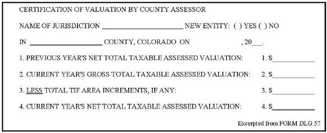
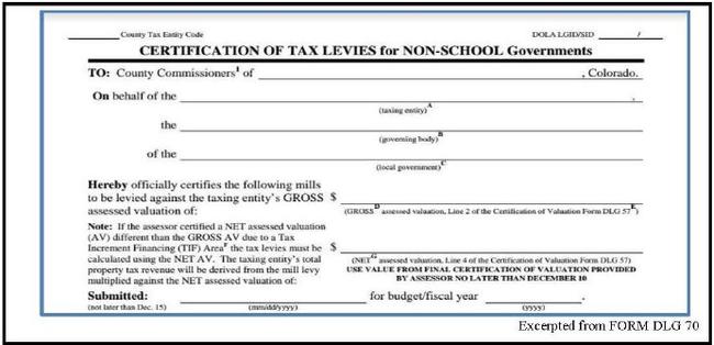
NOTE: A downtown development authority (DDA) may be both a taxing entity and have also created its own TIF area and/or have a URA TIF Area within the DDA’s boundaries. As a result DDAs may both receive operating revenue from their levy applied to their certified NET assessed value and also receive TIF revenue generated by any tax entity levies overlapping the DDA’s TIF Area, including the DDA’s own operating levy.
Taxing Entity Covers Part of TIF Area
Sometimes taxing entities encompass only a portion of the TIF area. They either lie fully within the TIF boundary but encompass only a portion of the TIF area, like the hole of a donut, or they lie both inside and outside the TIF boundary overlap only a portion of the TIF area. For both situations, that share of the increment which is proportionate to the taxing entity's portion of the total valuation in the TIF area should be deducted. Certifying more value than the taxing entity’s proportionate share of the increment would result in an excessive reduction of assessed valuation from which the entity’s portion of the property tax revenue is derived.
The steps for determining the entity’s proportionate share of the increment are as follows.
- Determine the total assessed valuation of those properties in the TIF area that are also within the taxing entity. This can be accomplished by assigning a special tax area code to such properties.
- Divide the total valuation of such properties by the total valuation of the entire TIF area.
- Multiply the resulting percentage by the total increment valuation to determine the amount of increment valuation certified to the taxing entity. This amount is deducted from the entity’s gross total assessed valuation to determine its net total assessed valuation.
The statutes specify that increment pertains to the total valuation for assessment that exceeds the base in such UR/DD area. So regardless of where within the UR/DD plan area the increment is derived, apportioning increment according to a ratio of the total value, or total area, is the only method permitted by statute.
Example 1: Entity fully within portion of TIF (donut hole)

TIF area total assessed valuation $10,000,000
TIF increment assessed valuation $ 2,000,000
Entity total assessed valuation $ 4,000,000
- Entity assessed valuation within the TIF area: $4,000,000
- Percent of entity TIF value to total value of TIF area: $4,000,000 ÷ $10,000,000 = 0.40 (40%)
- Amount of increment to be deducted from total valuation of entity: $2,000,000 × 0.40 = $800,000
Certified net total valuation of entity for levying purposes: $4,000,000 - $800,000 = $3,200,000
Example 2: Entity overlaps TIF area boundary

TIF area total assessed valuation $10,000,000
TIF increment assessed valuation $ 2,000,000
Entity total assessed valuation $ 4,000,000
- Entity assessed valuation within the TIF area : $1,000,000
- Percent of entity TIF value to total value of TIF area: $1,000,000 ÷ $10,000,000 = 0.10 (10%)
- Amount of increment to be deducted from total valuation of entity: $2,000,000 × 0.10 = $200,000
Certified net total valuation of entity for levying purposes: $4,000,000 - $200,000 = $3,800,000
Exception: 20-Year Extension Granted to DDA
As discussed above under 20-Year Extension to DDA TIF Area, a municipality may grant a 20-year extension of TIF in a DD plan area, after which the DDA receives only 50 percent of the revenue attributable to the increment value, unless a different percentage is negotiated with a taxing entity and certified to the assessor.
No later than August 1 of each year, the governing body certifies to the assessor the distribution percentages to the special fund for each taxing entity. When certifying values, the assessor applies the appropriate distribution percentage to the increment value and certifies only that percentage of increment value to the entity. However, the assessor reports the full value of the TIF area on the Abstract of Assessment.
The following illustration is an example of how an assessor can use a spreadsheet to track multiple different percentages to the DDA special fund based on different agreements with taxing entities. In this example, the first taxing entity is the St. Vrain School District, who shares back 100% from their general fund, but only the required 50% of revenue from their voter-approved mill levy override.
Exception 20-Year Extension Granted to DDA
Listing Increment in Certification of Levies Report
Counties with a TIF must complete an additional page in the Certification of Levies and Revenue form (DLG Form 3-CLR). When there is an increment, this form specifies the following:
- the name of the tax increment authority,
- the name of each entity that levies a tax in the TIF area,
- the assessed value of the increment for each entity and the amount of revenue generated from the increment by each entity, and
- the total assessed value and the amount of revenue generated from the TIF area.
When there is an increment in the TIF area, the county commissioners make the same levy for both the increment portion and the base portion of value. Thus, if the total levy of the taxing entities within the area is 90 mills, the levy for the increment is also 90 mills.
Concerning Treatment of Revenues Received by an Urban Renewal Authority Following Certain Voter-Approved Revenue Increases
Senate Bill 18-248 amended a section of Colorado’s urban renewal law that related to the incremental tax revenue generated from mill levies affected by voter-approved TABOR retain-and-spend provisions or voter-approved mill levy overrides. Such additional revenues may not be retained in the special fund of an urban renewal authority without the consent of the relevant taxing entity. The law requires this revenue to be repaid to the relevant taxing entity, and authorizes an authority and taxing entity to enter into an agreement governing the handling of these revenues. The provision applies to urban renewal plans adopted or substantially modified on or after January 1, 2016.
The intent of this bill was to remove the assessor from this process because it is a matter between the urban renewal authority and the taxing entity.
However, assessors may still be called upon to assist taxing entities and/or urban renewal authorities in understanding whether and when the provision applies, and how to proceed with implementation. Assessors should contact the Division for assistance if this occurs.
Information Listed in Tax Warrant
Section 39-5-129, C.R.S., states in part, “At the end of the warrant, the aggregate of all taxes levied shall be totaled, balanced, and prorated to the several funds of each levying authority, and the treasurer shall be commanded to collect all such taxes.”
In the case of a TIF area in which there is an increment, the property taxes for that area are totaled at the end of the tax roll. The proper amounts of the total taxes attributable to the base are prorated to each taxing entity in the area according to the mill levy for each such entity. The total taxes attributable to the increment are prorated to the special fund of the URA or DDA. This proration can be made by percentages or mill levies.
An illustration of how this can be done in a summary at the end of the tax warrant follows:
Assume the total base is $1,000,000 and the increment is $400,000, resulting in a total assessed valuation for the UR or DD area of $1,400,000.
Assume also that there are four taxing entities within the area and their current mill levies are:
| County | 0.020 |
|---|---|
| City | 0.015 |
| School district | 0.050 |
| Special improvement district | 0.005 |
| Total mill levy | 0.090 |
Total ad valorem taxes to be collected for area:
$1,400,000 × 0.090 = $126,000
Ad valorem taxes to be received by above four taxing entities:
$1,000,000 × 0.090 = $90,000
Ad valorem taxes to be paid into URA or DDA special fund:
$400,000 × 0.090 = $36,000
Example: Treasurer’s proration of taxes by mill levies:
| County | 0.020 x $1,000,000 base = $20,000 |
|---|---|
| City | 0.015 x $1,000,000 base = 15,000 |
| School district | 0.050 x $1,000,000 = 50,000 |
| Special improvement district | 0.005 x $1,000,000 = 5,000 |
| Totals | $90,000 |
Example: Treasurer’s proration of taxes by percentage:
The total ad valorem tax to be collected for the TIF area is $126,000. The percentage distributions of
| County | $20,000 ÷ $126,000 = 15.8730% |
|---|---|
| City | 15,000 ÷ $126,000 = 11.9048% |
| School district | 50,000 ÷ $126,000 = 39.6825% |
| Special improvement district | 5,000 ÷ $126,000 = 3.9683% |
| URA or DDA fund | 36,000 ÷ $126,000 = 28.5714% |
| Totals | $126,000 = 100.0000% |
Determining the Final Year
Calculating the Base and Increment
A TIF diversion may exist for a period not to exceed 25 or 30 years, except in the case of a DDA 20-year extension described previously. The only exception would be if the underlying bonds are in default.
The original base is calculated from the values last certified by the assessor prior to the approval of the plan containing the TIF provision. The August 25 preliminary certification of value is not used to produce the tax warrant. Rather, the final certification of value in December determines base and increment. If the plan was approved prior to the assessor certifying final values in December, the value of the initial base reflects the values as certified in December of the prior year. If the plan was approved after the final certification of values, the initial base reflects the values as certified in the current year. The first year in which it is possible to have increment is the year following the assessment year used for establishing the initial base.
Unless the approved plan specifies a more limited time frame, or the authority notifies the assessor that the indebtedness has been paid, the assessor should calculate base and increment for 25 or 30 consecutive tax years from the year used to establish the initial base.
Example 1: TIF Plan Approved Before Final Values are Certified
A UR plan with a TIF provision was approved on July 1, 2004. The initial base was established using 2003 certified values. Tax year 2004 was year one because it was the first year with the potential for an increment. The final year for calculating the base and increment is determined as follows:
2003 + 25 = 2028 (taxes collectable in 2029, or 2004 + 25 = 2029).
Example 2: TIF Plan Approved After Final Values are Certified
A DD plan with a TIF provision was approved on December 30, 2004. The initial base was established using 2004 certified values. Tax year 2005 was year one. The final year for calculating the base and increment is determined as follows:
2004 + 30 = 2034 (taxes collectable in 2035, or 2005 + 30 = 2035).
Final Year Revenue
Property tax revenue is collected in arrears from mill levies that are certified to generate a pre-determined annual revenue amount. For TIF, the anticipated revenue is calculated and divided at the time mill levies are certified, but some revenue is collected and/or adjusted after 25 or 30 years have expired from the date on which the TIF provisioned plan was approved. If the original base reflected values from the tax year in which the plan was approved (Example 2 above), the act of certifying the final year levies itself is likely to occur after 25 years have passed from the date on which the plan was approved. It is the Division’s position that the General Assembly intended for the TIF area to receive its proportionate share of revenue collected on tax bills issued pursuant to the tax warrant for the final tax year (year 25 or 30), even if the levies were certified more than 25 years and zero days from the date on which the plan was approved.
Abatements on Property in a TIF Area
Section 31-25-107(9)(a)(III), C.R.S., clarifies that an authority is obligated to repay its portion of revenue lost through abatements and refunds. The law allows county treasurers to offset future property tax payments to the URA and DDA on a pro rata basis. It requires that authorities make adequate provision for the return of overpayments and allows them to establish a reserve fund for that purpose or enter into an agreement to have the municipality in which the authority is established repay the money. If insufficient moneys are provided, the county treasurer may offset other allocations to the municipality. Any money that is required to be repaid cannot be pledged by the authority to repay bonds.
Court Cases Related to URA and TIF Issues
Following are some important court cases that assessors may refer to in order to gain a better understanding of how courts have interpreted TIF statutes. All of these are related to URAs but may be considered relevant when reviewing issues related to DDAs.
- Salient Issue: TIF Provision
- Denver Urban Renewal Auth. v. Byrne, 618 P.2d 1374 (Colo. 1980)
- Northglenn Urban Renewal Auth. v. Reyes, 2013 COA 24, 300 P.3d 984
- City of Aurora, AURA v. Marc Scott, 2017 COA (CASE NUMBER: 2016CA393)
- Salient Issue: Blight
- Rabinoff v. District Court, 145 Colo. 225, 360 P.2d 114 (1961).
- Interstate Trust Bldg. Co. v. Denver Urban Renewal Auth., 172 Colo. 427, 473 P.2d 978 (1970)
- Tracy v. City of Boulder, 635 P.2d 907 (Colo. App. 1981)
- City County of Denver v. Block 173, 814 P.2d 824 (Colo. 1991)
- Arvada Urban Renewal Auth. v. Columbine Prof’l Plaza Ass’n., 85 P.3d 1066 (Colo. 2004)
- Salient Issue: Standing
- E. Grand Co. Sch. Dist. 2 v. Winter Park, 739 P.2d 862 (Colo. App. 1987)
- Boulder County Bd. of Comm’rs v. City of Broomfield, 7 P.3d 1033 (Colo. App. 1999)
- Olson v. City of Golden, 53 P.3d 747 (Colo. App. 2002)
Residential Assessment Rate Adjustment
In 2020, the Colorado electorate voted to repeal the variable residential assessment rate requirement of the Gallagher amendment through the passage of Amendment B. Correspondingly, SB 20-223 was passed by the general assembly creating a moratorium on changing the assessment rates for any property class. It established the residential assessment rate at 7.15% for tax years commencing January 1, 2021 and later. The Gallagher amendment had been in place since 1982 and the history and methodology of its calculations are described below.
Until 1982, the assessment rate for both residential and non-residential property was 30 percent. However, beginning in the early 1970s, the market values of residential property increased much faster than values of non-residential property, shifting a greater percentage of the tax burden to residential property owners. In 1982, § 3(1)(b), art. X, COLO. CONST., was enacted to stabilize the tax burden on residential property. The amendment established a floating assessment rate for residential property while fixing the assessment rate for most other classes at 29 percent. The residential assessment rate (RAR) was to be adjusted during years of reappraisal to maintain a consistent ratio between the total statewide assessed values of residential and non-residential property. The Property Tax Administrator was responsible for performing the residential assessment rate study, § 39-1-104.2(4), C.R.S.
The General Assembly adjusts the residential assessment rate based on the findings of the study conducted by the Property Tax Administrator. The study begins with a calculation of the ratio of statewide residential to non-residential value for the prior reappraisal year. The ratio is then adjusted to account for new construction of residential and non-residential property that occurred during the prior two years. For the purpose of this study, new construction includes new real and associated new personal property, and the net change in production volumes of the natural resources, oil and gas, and producing mines classes if there was an increase in the assessed value of those classes over the two year period. If the assessed value of residential new construction is greater than the assessed value of non-residential new construction, the residential side of the ratio is likely to increase; if it is lower, the residential side of the ratio is likely to decrease.
The new ratio, also known as the “target percentage,” is the goal to be achieved through the establishment of the new residential assessment rate. A proportion problem was created in which the estimated statewide assessed value for non-residential property was applied to the ratio to calculate the assessed value for residential property. The residential assessed value was then compared to an estimated residential actual value to calculate the residential assessment rate.
Estimated values are used because the residential assessment rate study must be completed by April of each reappraisal year. This is prior to August when the new assessed values are reported by assessors in their Abstracts of Assessment.
For most property classes, two primary methods are used for making the estimates. Weighted monthly median sales ratio regression studies are performed on lists of qualified/verified sales that occurred during the appropriate data-gathering period, and in-depth interviews are conducted with county assessors and staff.
The final study completed in 2019 calculated a residential assessment rate of 7.15 percent for tax years 2019 and 2020. A history of changes to the residential assessment rate as it was enacted into law is shown below.
| Year(s) | RAR |
|---|---|
| Prior to 1983 | 30% |
| 1983-1986 | 21% |
| 1987 | 18% |
| 1988 | 16% |
| 1989-1990 | 15% |
| 1991-1992 | 14.34% |
| 1993-1994 | 12.86% |
| 1995-1996 | 10.36% |
| 1997-1998 | 9.74% |
| 1999-2000 | 9.74% |
| 2001-2002 | 9.15% |
| 2003-2004 | 7.96% |
| 2005-2006 | 7.96% |
| 2007-2008 | 7.96% |
| 2009-2010 | 7.96% |
| 2011-2012 | 7.96% |
| 2013-2014 | 7.96% |
| 2015-2016 | 7.96% |
| 2017-2018 | 7.20% |
| 2019-2020 | 7.15% |
Tax Relief
There are several tax relief programs to assist Colorado residents with reducing or delaying their property tax obligations. Senior citizen and veteran with a disability property tax exemption information can be found in Chapter 3, Specific Assessment Procedures. The Division publishes brochures explaining the various tax relief programs. The brochures may be viewed on the Division's website. For printable PDF versions of the brochures, please contact the Division.
Property Tax/Rent/Heat Rebates
This program is administered by the Colorado Department of Revenue. It is available to qualifying residential property owners and renters of residential property, § 39-31-101, et seq., C.R.S. The applications (Form 104 PTC) are filed with the Colorado Department of Revenue. An applicant has two years to file a Tax/Rent/Heat Rebate claim.
Additional information and assistance is available at the following Taxpayer Service Centers. You can obtain directions and hours of operation for each of these locations.
Colorado Springs Regional Service Center
2447 North Union Boulevard
Colorado Springs, CO 80909
Denver Metro (Lakewood) Service Center
1881 Pierce Street
Lakewood, CO 80214
Fort Collins Regional Service Center
3030 South College Avenue
Fort Collins, CO 80525
Grand Junction Service Center
222 South 6th Street, Rooms 208
Grand Junction, CO 81501
Pueblo Service Center
827 West 4th Street, Suite A
Pueblo, CO 81003
Tax Deferral
Beginning January 1, 2023, regardless of income, a senior citizen, any person called into military service, or a person who is not otherwise eligible for deferral may elect to defer the payment of the portion of real property taxes that exceed the person’s tax-growth cap for the year in which the person files a claim, pursuant to § 39-3.5-102, C.R.S. Real property taxes means ad valorem taxes levied on a homestead, including special assessments and other charges recoverable by law at the annual real estate tax sale, including the personal property tax sale of a mobile home, § 39-3.5-101(2), C.R.S.
“Tax-growth cap” means an amount equal to the average of the person’s real property taxes paid on the same homestead for the two property tax years preceding the year a deferral is claimed, increased by four percent.
Requirements for Eligibility
To qualify for the deferral, pursuant to § 39-3.5-102, C.R.S., the applicant must be either:
- An individual, 65 or older as of January 1 of the year claimed, or
A “person called into military service” on January 1, of the year in which a person files a claim.
Definitions.
(1.8) “Person called into military service” means a member of the Army National Guard of the United States, the Army reserve, the Naval reserve, the Marine Corps reserve, the Air National Guard of the United States, the Air Force reserve, or the Coast Guard reserve who has been ordered to active duty pursuant to 10 U.S.C. sec. 12301 (a) or 12302 for a period of more than thirty consecutive days in a time of war or national emergency declared by the congress or the president of the United States. “Active duty” includes any period during which a person called into military service is absent from duty on account of sickness, wounds, leave, or other lawful cause.
§ 39-3.5-101, C.R.S
- A person who is not otherwise eligible for deferral pursuant to § 39-3.5-102(1)(c)(I).
Limitations
In order to qualify for real property tax deferral, the property must meet all of the following requirements at the time the claim is filed and so long thereafter as payment is deferred.
- The taxpayer must not be earning income, such as rent, from the property, except if, the taxpayer is 65 years of age or older, is a taxpayer called into military service, or is the surviving spouse of a taxpayer who elects to continue the deferral,§ 39-3.5-103(1)(c), C.R.S.
- The taxpayer must own or be purchasing a fee simple estate or mobile home and occupy the residence. Residency elsewhere due to illness will not cause loss of the deferral, § 39-3.5-103(1)(b), C.R.S.
- All property taxes for prior years must have been paid, § 39-3.5-103(1)(e), C.R.S.
- The cumulative amount of the deferred taxes plus interest must not exceed the market value of the property less the value of any liens; otherwise title to the property could be lost, § 39-3.5-103(1)(f), C.R.S.
- Pursuant to § 39-3.5-103(1)(d.5)(I), C.R.S., the property shall not be eligible for the program unless the property meets either of the following requirements:
- Owner is 65 years of age or older, and the total value of all liens of mortgages and deeds of trust on the property, excluding any mortgage or deed of trust that the holder has agreed, on a form designated by the state treasurer, to subordinate to the lien of the state for deferred taxes, is less than or equal to 75% of the actual value of the property, as determined by the county assessor; or
- Owner is a person called into military service, or a person eligible for deferral under § 39-3.5-102(1)(c)(I), and the total value of all liens of mortgages and deeds of trust on the property, excluding any mortgage or deed of trust that the owner has agreed, on a form designated by the state treasurer, to subordinate to the lien of the state for deferred taxes, is less than or equal to 90% of the actual value of the property, as determined by the county assessor. Actual value of the property shall be the most recent appraisal by the county assessor as of the time the claim for deferral is submitted to the county treasurer. Pursuant to § 39-3.5-103(1)(d.5)(I)(B), C.R.S., this limitation does not apply to a person who has been called into military service and has a home loan that is guaranteed by the Veteran’s Administration of the United States.
- The minimum amount of real property taxes that may be deferred under this subsection 39-3.5-102(1)(c)(II) at one time is one hundred dollars ($100).
- The total amount of real property taxes that a person may defer under this subsection 39-3.5-102(1)(c)(II) for all years shall not exceed then thousand dollars ($10,000).
Procedures and Payment
- The claimant files an application/lien each year with the state treasurer between January 1 and April 1. The claim form must list the actual value of the property based on the assessor’s most recent appraisal.
- The state treasurer issues a certificate of deferral.
- Manufactured home owners must submit the title for recording the lien to the state treasurer.
- The state treasurer records the certificate of deferral with the county clerk and recorder’s office and sends a certificate of deferral to the county treasurer. This copy of the certificate is retained by the county treasurer’s office.
- The state treasurer charges interest beginning May 1 of the calendar year in which the deferral is claimed. Interest accrues at a rate equivalent to the rate per annum on the most recently issued ten-year United States Treasury note rounded to the nearest one-tenth of one percent, as reported by the “Wall Street Journal” as of February 1 of the calendar year in which such deferral is claimed.
- Any loan for deferred real property taxes, including accrued interest of a taxpayer who was a person in military service, shall not become payable upon the death of the taxpayer if the property is the homestead of the surviving spouse of the taxpayer, and the property meets other statutory requirements.
The county treasurer and the state treasurer will deny requests from individuals, corporations, or other private entities to inspect or produce the names, addresses, phone numbers, social security numbers, or other information identifying individuals who participate in the deferral program, § 39-3.5-119(1), C.R.S. This provision does not prohibit individuals from examining documents recorded with the clerk and recorder’s office, nor does it prohibit the disclosure of information required in connection with granting or denying a claim for deferral; required in connection with an administrative, judicial, or other legal proceeding; required in connection with the conveyance, sale, or encumbrance of a specific property; when the information is contained in a statistical compilation or other informational summary that does not disclose individual identifying information; or when the individual claiming the exemption has agreed to the disclosure, § 39-3.5-119(2), C.R.S.
Payment of Deferred Taxes
Pursuant to § 39-3.5-110, C.R.S., deferred taxes must be paid when:
- The claimant dies.
- The property is sold or title transfers to another person.
- The taxpayer moves for reasons other than poor health.
- The taxpayer rents the property or otherwise receives income from it.
- The location of the tax-deferred manufactured home has changed within the county or to another county.
All deferred taxes plus interest are due within one year of the death of the owner or in 90 days for other causes listed above. Taxes may be paid at any time without affecting the deferred status. If property taxes are paid as part of a mortgage payment, a certificate is presented to the mortgagor for refund of the property tax monies held in escrow. The property may be given to the state of Colorado in lieu of payment. If the taxes are not paid, the state of Colorado will foreclose on the property, § 39-3.5-111, C.R.S.
Deferred taxes are not payable, pursuant to § 39-3.5-112, C.R.S., when:
- The spouse of the taxpayer has elected to continue the deferral for that year if the spouse is 60 years of age or older and meets all other requirements of §§ 39-3.5-103(1)(b) and (1)(c), C.R.S.
- The spouse of the taxpayer of a person that was in military service, or was a person eligible for deferral under section 39-3.5-102(1)(c), has elected to continue the deferral for that year and meets all other requirements of §§ 39-3.5-103(1)(b) and (1)(c), C.R.S.
The spouse of the taxpayer or the spouse of the person that was in military service does not need to repay the deferred tax until the property is sold, changes into an income producing property, or title is transferred to someone other than the surviving spouse, §§ 39-3.5-110 and 39-3.5-112, C.R.S.
Required Forms
The deferral claim form may be obtained from the state treasurer. The county treasurer may enclose a deferral form reminder with the tax notice; however, the claimant must apply annually whether the reminder is received or not.
More information is available at the Property Tax Deferral Program website.
Property Tax Work-Off Program
Individual taxing entities such as a county, city and county, city, town, school district or special district, administer the property tax work-off program. The program allows taxpayers who are 60 years of age or older, a first responder with a permanent occupational disability, defined in § 33-4-104.5(2), C.R.S., or a person with a disability, defined in § 25.5-10-202, C.R.S.; to perform work for minimum wage in lieu of paying all or a portion of the property tax due to the entity, §§ 39-3.7-101 and 102, C.R.S.
Any taxpayer who is a first responder or a person with a disability that applies to participate in a property tax work-off program must include with their application either a signed and dated letter from the fire and police pension association verifying that the taxpayer is a first responder with a permanent occupational disability or a signed and dated letter from a Colorado licensed health care professional verifying the person has a disability.
Each participating entity establishes procedures for its program and must make information regarding the program available to the taxpayers living within the boundaries of the taxing entity.
NOTE: Not all entities may choose to participate in the program. Taxpayers that qualify must contact their respected taxing entities.
Homestead Exemption
In addition to the senior citizen and veteran with a disability exemptions described earlier in this chapter, Colorado statute also establishes a homestead exemption from execution and attachment arising from any debt, contract, or civil obligation not exceeding:
- $250,000 if the homestead is occupied as a home by an owner or an owner’s family; or
- $350,000 if the homestead is occupied as a home by an elderly or disabled owner, or elderly or disabled spouse of an owner, or an elderly or disabled dependent of an owner.
This exemption, found in §§ 38-41-201 through 212, C.R.S., has no bearing on an assessor’s duties or functions.
Mobile Home and Manufactured Home Exemption
For tax years commencing on or after January 1, 2022, titled manufactured and titled mobile homes with an actual value of less than or equal to $28,000 are exempt from the levy and collection of property taxes, § 39-3-126.5(3). This exemption is not available for manufactured and mobile homes that have received a certificate of permanent location or affidavit of real property.
Prepayment by Energy and Mineral Operations
The Colorado General Assembly has authorized prepayment of ad valorem taxes by qualified energy and mineral operations. The intent of the prepayment legislation located in article 1.5 of title 39, C.R.S., is that large, developing energy and mineral operations should be authorized to prepay ad valorem taxes to local governments for expenditure on capital improvements so that local governments can meet additional public service demands created by such operations. The additional demands for public service are usually created during the development or construction phases of such operations, prior to the generation of additional tax revenue.
Qualifications for Prepayment
To be authorized to prepay ad valorem taxes to local government entities:
- The venture must be an energy or mineral operation.
“Operation” is the development, construction, and operation of any facility for either or both the:- Production of energy, i.e., a power plant;
- Extraction, processing, conversion, or refining of minerals, including but not limited to a mine; oil and gas production, whether conventional or from oil shale; a mill, retort, refinery, smelter; or, related facility or combination thereof.
- The operation must be under the same ownership.
- The estimated assessed valuation of the operation must exceed $50,000,000 when it begins functioning.
- The taxable property of the operation must be located within the boundaries of the local government entity which will receive the prepayments.
Voluntary Prepayment
An owner of an operation may elect to prepay moneys to one or more local government entities for credit against general property taxes, which will be levied in the future.
The owner is not obligated by law to agree to a prepayment arrangement. The owner may agree to prepayments to one or more taxing entities, but such agreement does not require prepayments to all the taxing entities in the tax area.
A prepayment to one or more local government entities does not affect the operation’s obligations to pay general property taxes to the other taxing entities in the area which do not receive such prepayment.
Prepayment moneys can be expended by the local government only on capital improvements which are directly or indirectly related to the additional public service demands created by the operation.
“Capital improvement” means any road or highway; school facility or equipment; domestic, commercial, or industrial water facility; sewage facility; police and fire protection facility or equipment; hospital facility or equipment, or any other local government administrative or judicial facility which a local government is authorized by law to acquire or construct, § 39-1.5-102(1), C.R.S.
Prepayment Agreement and Limitations
The owners of the operation and the governing board of the local government entity, which will receive the prepayments, must jointly determine and agree upon:
- Total amount of prepayments to be made: The total amount of the prepayments cannot exceed 25% of the estimated tax liability to the local government over a 20-year period, beginning in the year in which the assessed value of the operation is estimated to exceed $50,000,000.
Example:
Assume that the county is to receive the prepayments; that the total county mill levy is expected to be approximately 20 mills for the next 20 years; and that the assessed valuation of the operation should average $50,000,000 for the 20-year period.
In this oversimplification, the operation’s projected tax liability to the county would be $1,000,000 per year, and the total projected tax liability for the next 20-year period would be $20,000,000 as shown below:
$50,000,000 Value × 0.020 = $1,000,000 Taxes per year
$1,000,000 Per year × 20 Years = $20,000,000 Total taxes
The total amount of the prepayments in this case cannot exceed 25% of $20,000,000, which is $5,000,000.
- When the prepayments are to be made: Prepayments may be made by the operation prior or subsequent to the year in which it begins functioning or when its assessed valuation exceeds $50,000,000. There may be only one prepayment, or there may be several prepayments, which extend over a period of time.
- The amounts of annual credits for prepayment to be allowed: There are two limitations, which affect the credit against property taxes that can be allowed to the operation in any year.
- An annual prepayment credit shall not be allowed prior to the taxable year in which the operation begins functioning or the assessed valuation of the operation exceeds $50,000,000, whichever is earlier.
- An annual prepayment credit shall not exceed 25% of the taxes due from the operation to the local government entity for the then current tax year.
Example of Prepayment, Credit Amounts and Intervals
The following is a hypothetical example. We will presume that this example is in compliance with all provisions required by TABOR.
A new mining operation, which is expected to employ 1,500 workers, is being developed in the county. The job requires the use of several pieces of heavy equipment which over the course of the project will cause above average wear and tear on the public roads and bridges.
As such, the board of county commissioners feels it must allocate some funding for road and bridge repair. However, the current assessed valuation of the county is too low to permit these additional expenditures from property tax revenue. The mining operation has indicated it would be willing to prepay a portion of its future property taxes to help with the repair of the damaged roads and bridges. Meetings of the county officials with officials of the mining operation are held to explore this proposal. As a result, the following prepayment and credit items are agreed upon:
- The total assessed valuation of the mining operation within the county boundaries should exceed $50,000,000 in 2018, which is also the year production commences.
- The total assessed valuation of the operation is expected to exceed $50,000,000 for the following 20 years, assuming there will be no radical changes in demand for the product, in the general economy, or in property taxation laws.
- The county mill levy is almost 20 mills and increases are subject to the requirements in section 20 of article X of the Colorado Constitution. Based on $50,000,000 assessed valuation, the operation’s property tax liability to the county in 2016 would be $1,000,000 ($50,000,000 Valuation × 0.020 Levy = $1,000,000). If the county levy remains at approximately 20 mills, the projected tax liability of the operation for the following 20 years would be $20,000,000 ($1,000,000 × 20 Years = $20,000,000).
- The operation will prepay a total of $2,000,000 property taxes to the county. $1,000,000 will be paid in each of the years 2016 and 2017. These prepayments will be in addition to any current property taxes due in each of these two years.
The maximum total amount of prepayments the operation could have agreed to would have been $5,000,000. This figure represents the 25% limitation of the operation’s projected tax liability to the county over a 20-year period ($20,000,000 total tax liability over 20 years × 0.25 = $5,000,000.). - The $2,000,000 total prepayment will be credited against the operation’s annual property tax liability at the rate of $250,000 per year for 8 years, beginning in 2016. The maximum allowable annual prepayment credit is 25% of the property taxes due to the county each property tax year. In this case, the annual tax liability to the county has been projected at $1,000,000 for 2017. Therefore, the annual credit cannot exceed $250,000 for that year ($1,000,000 Tax liability × 0.25 Maximum = $250,000).
- The projected prepayment and credit schedule agreed upon is listed below. It is based on the assumption that the operation’s tax liability to the county will be $1,000,000 in 2017 and will rise 5% per year due to valuation increases.
| Year | Property Tax Prepayment Amount | Property Taxes Due | Total Prepayment Credit | Minus Net Property Taxes Due |
|---|---|---|---|---|
| 2017 | $1,000,000 | $450,000 | $450,000 | |
| 2018 | $1,000,000 | $700,000 | $700,000 | |
| 2019 | $1,000,000 | $250,000 | $750,000 | |
| 2020 | $1,050,000 | $250,000 | $800,000 | |
| 2021 | $1,102,500 | $250,000 | $852,500 | |
| 2022 | $1,157,625 | $250,000 | $907,625 | |
| 2023 | $1,215,506 | $250,000 | $965,506 | |
| 2024 | $1,276,282.00 | $250,000 | $1,026,282 | |
| 2025 | $1,340,096 | $250,000 | $1,090,096 | |
| 2026 | $1,407,100 | $250,000 | $1,157,100 | |
| Totals | $2,000,000 | $2,000,000 | $250,000 |
Estimating Projected Valuation and Tax Liability
Pursuant to § 39-1.5-104, C.R.S., prior to the adoption of a formal agreement and resolution or ordinance pertaining to the total amount of prepayments and the amounts and intervals of the prepayments and the prepayment credits, a joint estimate shall be made by the following:
- The owner of the operation,
- The governing body of the local government which will receive the prepayments,
- The county assessor,
- The county treasurer, and
- The Division of Property Taxation.
The joint estimate shall include a determination of:
- The taxable year in which the assessed valuation of the operation will exceed $50,000,000.
- The total assessed valuation of the operation for the subsequent 20 years, and
- The projected property tax liability of the operation for the prepayment credit period, which cannot exceed 20 years.
By necessity, the estimate must be based primarily on the operation’s projected expenditures on land, improvements, and equipment, and its projected income from extraction of minerals or production of energy.
The assessor is an interested party to the estimate because the assessor will be listing and valuing the taxable property of all or part of the operation in accordance with the property tax provisions of the state constitution and statutes.
The Division of Property Taxation is also logically included in the estimating process. Part or all of an operation could be state assessed by the Division, as in the case of a power-generating plant.
If the operation should be locally assessed, the Division may become involved in valuation assistance or supervision. In addition, the Property Tax Administrator will be involved in the abatement process, which will be necessitated later by the prepayment credits.
The governing body of the local government, which will receive the prepayment moneys, is obviously an interested party to the estimate. It must know the anticipated amounts and intervals of the prepayments so that it can make proper budget and expenditure plans. It must also have a reasonable approximation of the future tax liability of the operation and know how much that liability will be offset by the prepayment credits.
The county treasurer is an interested party because the treasurer will be administering and accounting for the prepayment credits.
Prepayment Credit Treated as an Abatement
Credit allowed for prepayments does not affect the valuation of the property. The proper assessed valuation of the operation is to be determined each year as provided by law regardless of any tax prepayments or credit for prepayments.
The prepayment credit is to be shown on the tax statement for each taxable year that it applies to a local government, fund, or fund account. The general format for showing the credit would be:
Total property taxes due taxing entity $ xxxxxx.xx
Less tax prepayment credit allowed - xxxx.xx
Net property taxes due $ xxxxx.xx
The credit allowed in any taxable year for prepayments made to a local government shall be treated as an abatement of the property taxes due that local government for that year from the operation. Unlike other abatements which affect the revenue of each taxing entity within the specific tax area, a prepayment credit abatement will affect only the local government which received the prepayments.
This abatement provision does not affect the assessment roll while it is still in the possession of the assessor. The total assessed valuation of the operation shall be listed in the roll, along with the several levies applicable to the valuation and the total amount of such taxes levied against the valuation.
As an alternative to the completion and approval of an abatement petition each year an annual prepayment credit is allowed. The following one-time procedure may be implemented if all the involved parties agree.
The governing body of the local government, which is to receive tax prepayments, must adopt a resolution or ordinance which contains all the provisions relating to such prepayments and credits. The resolution could also contain statements to the effect that:
- The governing board acknowledges that each annual prepayment credit allowed is to be treated as an abatement of the property taxes due to the local government for the year the credit is allowed.
- The Property Tax Administrator has participated in the estimates to the operation’s future valuation and property tax liabilities and has knowledge of the anticipated amounts and intervals of prepayment credits.
- The Property Tax Administrator acknowledges that each annual prepayment credit shall be treated as an abatement, and that the resolution shall serve as an application for all such future prepayment credit abatements.
- The Property Tax Administrator finds that the abatement application is in proper form, is in conformity with the law, and is approved.
- The governing body, the county commissioners, and the Property Tax Administrator find and agree that the resolution and application shall serve as authorization to the county treasurer to abate each annual amount of tax prepayment credit allowed in that taxable year.
The resolution, or the abatement statements within it, would be signed by the governing body, the county commissioners, and the Property Tax Administrator. Such a resolution then serves as the approved abatement for the tax prepayment credits as they are allowed. All the legal steps of an abatement have been fulfilled in the resolution. Because this process is in conjunction with a voluntary prepaid agreement between the government entity and the operator, it is outside the statutory abatement process, and does not warrant refund interest.
Resolution to be Adopted by Local Government
The tax prepayment law requires that the governing body of the local government, which receives property tax prepayments, shall adopt a resolution or ordinance that must contain:
- A description of the capital improvement or improvements for which the tax prepayment moneys will be spent.
- A listing of the total amount of taxes to be prepaid with the anticipated amounts and intervals of the prepayments.
- If the one-time abatement procedure is to be used, a provision stating that prepayment credits shall be treated as an abatement of taxes and that all necessary parties have agreed the resolution shall serve as the approved abatement. If an abatement petition is to be submitted to the Property Tax Administrator for the applicable credit, this provision is not required.
Prepayment/Credits Do Not Affect Levy Limitation
Two provisions apply concerning tax prepayments and credits when determining the amount of revenue the local government is allowed to levy under § 29-1-301, C.R.S.:
- Tax prepayments are not to be considered property tax revenue to the local government in the year in which they are paid.
- The amount of tax liability against which a credit for prepayment is to be allowed is considered to be property tax revenue in the year in which the credit is allowed. However, it is considered to be tax revenue attributable to increased valuation for new construction or bond revenue, both of which are excluded when determining the statutory revenue limit.
Because of these two provisions, the assessor’s certification of value to the local government which received prepayments is not affected by either prepayments or credits for prepayments. Certification of the total valuation for assessment is made in the same manner as for any other taxing entity. Prepayments and credits for prepayments are ignored by the assessor when preparing certification of value.
The county treasurer collects the tax and, therefore, is the official responsible for administering each allowable annual tax prepayment credit. Before allowing an annual credit, the treasurer must ascertain that the amount allowed does not exceed 25% of the taxes due from the operation to the local government for the current year, § 39-1.5-104(1)(a), C.R.S.
The treasurer will then set up special procedures for allowing the credit and showing the amount of the credit on the operation’s tax statement, § 39-1.5-104(4), C.R.S.
Renewable Energy Incentives
Colorado does not have any general statewide property tax incentives for renewable energy. However, §§ 30-11-107.3 and 31-20-101.3, C.R.S., allow county and municipal governments to “offer an incentive, in the form of a [county/municipal] property tax or sales tax credit or rebate, to a residential or commercial property owner who installs a renewable energy fixture on his or her residential or commercial property.”
Introduction
All land is subject to ownership, whether by governmental or private entities. In order to physically and legally establish this ownership, a need to describe the boundaries of the land was created. The resulting method of land description, called a legal description, identifies a parcel of real property in such terms that it cannot be confused with any other parcel.
The purpose of this section will be to explain the various land description methods and how to rewrite legal descriptions to a condensed form.
Land Description Methods
There are four primary methods of land legal descriptions used in identifying land in Colorado. The methods are:
- United States Governmental Survey System, often referred to as the "rectangular survey system"
- Metes and bounds
- Lot and block system, sometimes called the "recorded plat system"
- Colorado Coordinate System
In addition, some land descriptions in several southern Colorado counties refer to the original land grant. Although these land grants are still referenced, all parcels within the original grants have alternative metes and bounds descriptions.
United States Governmental Survey System
Background
After the Revolutionary War, new areas of the United States public domain were added through discovery, treaties, and purchases. It became apparent to our government leaders that a plan must be worked out for selling and locating lands in this added territory.
In 1784, a committee headed by Thomas Jefferson authored the original rectangular survey plan, which was adopted by the Continental Congress. From 1785 to 1832, this plan underwent modification until the smallest statutory unit of subdivision was the quarter-quarter section (40 acres). This system became the principal land survey system for several states east of the Mississippi River and for most lands west of the Mississippi River. Any land settled prior to the act was not included and is still described by a metes and bounds description.
Base Lines and Principal Meridians
The purpose of the United States Government Survey System was to create a checkerboard of identical squares covering a given area of land. The first step in using this system was to establish an imaginary line running east and west, called a base line, and another imaginary line running north and south, called a principal meridian. These lines were tied, by celestial observations, to the worldwide system of latitude (east and west), and longitude (north and south) measures.
In Colorado, the three principal meridians and base lines in use are:
- The Sixth (6th) Principal Meridian and the Forty Degrees North Latitude Base Line
- The New Mexico Principal Meridian and the New Mexico Base Line
- The Ute Principal Meridian and the Ute Base Line
For an illustration of the principal meridians and base lines governing Colorado, please refer to Addendum 13-A, Public Land Survey System in Colorado, found at the end of this section.
After establishing the base line and principal meridian, the second step was dividing the land into six-mile square areas. This established parallel lines six miles apart both east and west of the principal meridian and parallel lines six miles apart both north and south of the base line. The lines running parallel to the base line are called township lines. The lines running parallel to the principal meridian are called range lines.
Typically, the range line that lies every 24 miles east and west of the principal meridian is also called a guide meridian. Each guide meridian ends where the line intersects a standard parallel. The purpose of this line is to act as a correction line to adjust the rectangular townships to the curvature of the earth.
Standard parallels, often called correction lines, serve the same purpose as guide meridians. Typically, standard parallel lines are the township lines located every 24 miles north and south of the base line.
In Colorado, the original surveys done in the 1800s created guide meridians and standard parallels at different intervals other than the 24-mile interval currently used. Meridians and parallels created pursuant to these old surveys are still valid. In addition, auxiliary guide meridians and standard parallel lines were established when additional governing lines were needed. Auxiliary meridians and parallel lines are similar to regular meridians and parallels. Refer to Figure 1 for an illustration of meridians, baselines, townships, and ranges.
Townships and Sections
When township lines and range lines intersect, they create rectangles called townships. A standard township is six miles square and contains 36 square miles. Because of the earth’s convergence of longitude lines, townships are about 3 rods or 49.5 feet narrower at the top (north) than at the bottom (south).
Each township is further divided into 36 one-mile square tracts called sections. Refer to Figure 2 for an illustration. A standard section contains 640 acres. Sections within a township are numbered consecutively from the northeast corner, following a back and forth course, until the last section in the southeast corner is numbered. At each of the four section corners, government surveyors placed a marker known as a “survey monument.” The composition of a survey monument depends on what materials were available in the locale under survey.
In most of Colorado, rocks were piled with one prominent stone selected as the marker. “Hash marks” or lines in the rock were chiseled indicating the location of the section within the township. In areas with few rocks, wooden posts or even growing trees were used.
Understanding the Rectangular Survey System
The proper understanding and writing of a legal description requires the reader to go from the specific to the general. The cardinal compass directions (north, south, east, and west) are used to locate tracts within each section. For purposes of land description, sections are commonly divided into half sections containing 320 acres, quarter sections containing 160 acres, and so forth. A legal description is written by describing the exact tract within the section and ends with the name of the principal meridian. An example legal description of a 40-acre parcel of land is:
NE¼SE¼, section 6, township 3 north, range 6 west, 6th Principal Meridian.
It is very important that the proper punctuation be used in separating the initial components of the description. The above description showing NE¼SE¼ without a comma between the two quarters is the NE¼ of the SE¼, a 40-acre tract.
By placing a comma between the quarters for example, NE¼, SE¼, a 320-acre tract more commonly known as the E½ of the section is described. Commas should also separate the section, township, and range so that the intent of the description is clear. Refer to Figure 3 and Figure 4 for illustrations of both tracts mentioned.
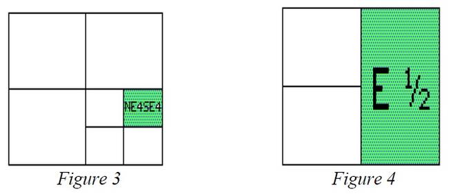
Government Lots
Government lots are tracts of land which usually exist adjacent to the northern and western borders of each township. Because of the curvature of the earth, the convergence of the longitude lines or meridians, and human errors, the subdivision of townships into sections could not be surveyed as accurately as it could be drawn on paper. To take care of these discrepancies and still have as many uniform sections of 640 acres in each township as possible, corrections to the sections were made on the north and west sides of each township. Consequently, sections 1 through 6 on the northern township border and sections 6, 7, 18, 19, 30, and 31 on the western township border may contain either more or less than 640 acres. Corrections within these specific numbered sections were made in that fraction of the section lying closest to the north and west lines of the township. These odd-sized subdivisions of a section were referred to as “government lots.” Government lots are given individual lot numbers rather than being described by compass directions, because they contain more or less than 40 acres of land. In the example shown in Figure 5, a tract of land, known as the NE¼NE¼ of Section 6, is assigned government lot number 1.
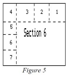
The use of lot numbers in legal descriptions is the proper way to describe these tracts. However, a cross reference can be made to show the location of the lot involved. For example, this description is proper:
Lot 1 (NE¼NE¼) of section 6, township 4 south, range 64 west, 6th Principal Meridian
Government lot numbers were also used when physical barriers prevented the establishment of complete 40-acre tracts. Lots were established where rivers, lake, and cliffs were located on the land under survey, as shown in Figure 6. Governmental lots established because of physical limitations can occur in any section of a township.
Obtaining Information on U.S. Government Surveys
When an original government survey was completed, a copy of the surveyor’s field notes was filed in the office of the county clerk and recorder, with the county engineer, or both. However, these field notes may require an engineer or surveyor to translate them. The best source of information for data pertaining to the original survey or resurveys is the Bureau of Land Management (BLM). Data available from this agency includes, but is not limited to:
- Initial survey and resurvey plats, (if any)
- Surveyor’s field notes
- Mineral survey plats and field notes
- Lot numbers, acreage, and acreage re-surveys
- Original patents
- Unpatented claims
For additional information and copies of maps of the above information, contact the BLM at:
United States Department of Interior
Bureau of Land Management - Colorado State Office
2850 Youngfield Street
Lakewood, CO 80215
Bureau of Land Management Website
Phone: 303-239-3600
Metes and Bounds Descriptions
In Colorado, the predominant method of land description is the government rectangular survey system. However, in areas not covered by the rectangular survey system or when it is necessary or desirable to describe an irregular tract, the land is described by metes and bounds.
Metes and bounds descriptions come from a system that measures and identifies land by describing the land’s boundaries, based on the land’s relation to its natural and cultural features. These features are called monuments. This method starts with a well-marked point of beginning and follows the boundaries of the parcel until it returns to the point of beginning.
Metes and bounds descriptions are expressed in bearings and distances. The direction of a line (its bearing) is stated in terms of the angle it makes with a true north-south line through the point of beginning. A bearing is described in degrees and fractions of a degree (minutes and seconds) from the cardinal directions of north or south, such as N 87º 29' 45" E 482 feet. A distance is the length of a line. It is generally stated in feet, but may also be stated in chains, rods, or other lineal measurements. A conversion chart is provided in Addendum 13-B, Typical Measurement Units and Conversions.
Every modern bearing has degrees and minutes of angulation, and sometimes, even seconds. There are 360 degrees (360º) in a complete circle with 180º between north and south or between east and west. Between north and east, north and west, south and east, and south and west there are 90o. If you were to measure N. 90º E., you would be measuring due east. In each degree (º), there are 60 minutes (60'); 30' is 1/2 a degree; 15' is found halfway between the degree and the half-degree marks. In each minute (') there are 60 seconds (60").
Example - Metes and bounds description
A tract of land in the northwest one-quarter of the northwest one-quarter (NW¼NW¼) of section 30, township 1 south, range 60 west of the 6th P.M., more particularly described as follows: Commencing from the northwest corner of said section 30; thence south 20º30' east 140.60 feet to the point of beginning; thence north 88º55' east 200 feet; thence south 125 feet; thence south 88º55' west 200 feet; thence north 125 feet to the point of beginning, County of Adams, State of Colorado.
Metes and bounds descriptions used in Colorado always tie to some established corner or line of an existing public lands survey or to recognized corners or lines of a recorded plat. Metes and bounds should be established by a registered land surveyor. Surveys cannot be used as official description reference unless made by a registered surveyor.
NOTE: Documents executed and recorded after July 1, 1992, which contain a newly created legal description must include the name and address of the person who created the legal description, § 38-35-106.5, C.R.S.
In several Colorado counties, large tracts of land known as land grants exist and are referenced in legal descriptions. Under a land grant, large tracts of unsurveyed and generally uninhabited land were conveyed to individuals and/or companies. The tracts were later divided into large agricultural tracts and/or smaller lot and block town sites.
Nearly all the land grants in Colorado are called Spanish land grants. These land grants were given by the king of Spain to favored individuals for services rendered to the Crown. Today, the boundaries of these grants have been established by metes and bounds descriptions and are subdivided into parcels described by metes and bounds and/or the rectangular survey systems.
Lot and Block Descriptions
The lot and block method is one of the earliest land description methods. Lots and blocks were used in Colonial America before the rectangular survey system was instituted.
In Colorado, the lot and block method began when land developers subdivided land described by the rectangular survey system and needed more detail to identify the individual sites they were creating. Each block and lot can be identified and located in relation to the monumented corners established as part of the subdivision boundary metes and bounds description. The subdivision boundary is then “tied” to government survey points of the original rectangular survey.
A tract of land may be subdivided into blocks and lots, with proposed streets, alleys, public utility easements and such other information that the owner desires to include as part of the plan for the tract. A map, called a plat, is created which identifies all blocks and lots by number and shows boundaries and measurements of the lots, blocks, and complete land tract. The plat is then submitted to the local planning commission and/or county commissioners for approval.
After the required local governmental approval, the plat is recorded in the office of the county clerk and recorder for permanent reference. Any lot of a recorded plat can thereafter be legally described and conveyed by simple reference to the lot and/or block numbers as shown on the plat. Each platted area is given a name, such as “Pine Meadows Subdivision” or “Riverside Addition” to distinguish it from other subdivided areas.
Example - Lot and block description from a recorded plat
“Lots 4 and 5, Block 26, Riverside Addition to the City of Fort Morgan, Colorado”
Colorado Coordinate System
The Colorado coordinate system is part of the state plane coordinate system established in 1933 by the United States Coast and Geodetic Survey agency, which later became the United States Geodetic Survey. This state plane coordinate system locates the boundary points of land parcels on a state coordinate grid in the same manner as graph paper is used to locate the points of a line graph. The state coordinate system is comprised of rectangular grids designed to fit the curved shape of the earth to a plane (flat) surface with as little distortion as possible.
A coordinate system establishes a set of two or more numerical values used to determine the position of a point, line, curve, or plane. For example, the intersection of latitude and longitude lines are coordinates for a point on the earth’s surface. For many years, professional land surveyors and engineers have used various types of coordinate systems.
In using the system, a point on the boundary of a tract is expressed in two distances in feet and decimals of a foot. An east-west direction is known as the "X-coordinate" and the north-south direction is known as the "Y-coordinate." The precise coordinates for the points of origin have been determined by the National Geodetic Survey. A sample is provided in Figure 7.
The United States is covered by a network of triangulation and traverse stations which determine the latitudes and longitudes of thousands of benchmark points. For each state, the U.S. National Geodetic Survey has devised a system of plane-rectangular coordinates for the purpose of stating the locations of established monuments and other points with reference to a point of origin.
Because Colorado is a large state, the state coordinate system is divided into three zones, each of which has its own plane-rectangular map projection. The appropriate zone must be stated in the legal description. When any tract of land to be defined by a single description extends from one zone into another, the positions of all points on its boundaries may be described according to either of the two zones. The zone used must be specifically named in the description.
Whenever the Colorado Coordinate System and the rectangular survey system are used to describe a tract of land in the same document, the description by rectangular survey shall control. In the event of a conflict of the two descriptions, the rectangular survey description shall prevail unless the coordinate description is upheld by adjudication.
Example – Metes and bounds description using state plane coordinates as supplemental information
Commencing at the corner of section 20, 21, 28, and 29, township 4 south, range 75 west, 6th P.M. and bearing north 20º15' west 202.50 feet to the point of beginning which is marked by a 5/8" diameter iron rod set in concrete; then bearing north 79º45' West 155 feet to a brass marker set in a granite ledge and stamped “2928,” said brass marker having grid coordinates X=1,916,572.14, and Y=624,697.82, on the Colorado Coordinate System, Central Zone; then south 22º45' west 106.50 feet; then south 70º15' east 145 feet; then north 25º30' east 133.50 feet to the point of beginning.
In Colorado, as in most states, the plane coordinate system developed by the National Geodetic survey has been approved by an act of the general assembly. The Colorado Coordinate System became effective July 1, 1967 and sections 38-52-101 through 107, C.R.S., pertain to its establishment and use. Its use is not mandatory at this time, but the system may become commonplace in the future.
For further information on this method of land description, refer to the Colorado Coordinate System statutes or contact a registered land surveyor.
Condensing Legal Descriptions
Many assessment roll legal descriptions in Colorado can be condensed by 25 to 50 percent. To create a condensed legal description:
- Rewrite descriptions in a shorter format;
- Use accepted abbreviations; and
- Eliminate unnecessary words and phrases.
Legal descriptions should not be condensed in any other manner.
Rewriting Legal Descriptions
Colorado statute allows for legal descriptions to be rewritten by the assessor.
Property described.
In listing tracts or parcels of real property, the assessor shall identify the same by section, or part of a section, township, and range, and if such part of a section is not a legal subdivision, then by some other description sufficient to identify the same. In listing town or city lots, he shall describe the same by number of lot and block, or otherwise, in accordance with the system of numbering or describing used by the town or city in which said lots are located.
§ 39-5-103, C.R.S.
An assessor has the authority to rewrite any description. The description is considered valid if it correctly and effectively describes the parcel so the parcel cannot be confused with any other parcel.
Descriptions should be rewritten only after parcels have been plotted on assessment maps. Information pertinent to each parcel, such as bearings or angles, distances, and acreage should be entered on the assessment maps. Condensed descriptions are written from information on the deed and assessment map and old descriptions from the assessor’s records. The condensed descriptions should be rechecked later for errors.
In understanding legal descriptions, you may encounter unfamiliar measurement terminology. Refer to Addendum 13-B, Typical Measurement Units and Conversions, for measurement terms.
Using Accepted Abbreviations
Abbreviations may be used for purposes of property taxation and collection.
Abbreviations, letters, and figures may be used.
In all advertisements for the sale of real property for taxes and in entries required to be made by the assessor, county clerk and recorder, treasurer, or other officers in lists, books, rolls, certificates, receipts, deeds, or notices, letters, figures, and abbreviations may be used to denote townships, ranges, sections, parts of sections, lots, blocks, dates and amounts of taxes, penalty interest, and costs.
§ 39-11-113, C.R.S.
Refer to Addendum 13-C, List of Abbreviations, listing of suggested abbreviations.
Eliminating Excess Words and Phrases
All words that are unnecessary to correctly and effectively describe or plat a parcel may be eliminated. When the bearing and distance is given for a course or meander, everything except the bearing and distance is unnecessary. In the following description, the most common forms of excess wordage found in deed descriptions are illustrated. The parts not underlined could be eliminated.
That part of the S½ of the NE¼ of the NE¼ of Sec 12, T 10 N, R 57 W commencing at the NE corner of said NE¼ of the NE¼ Sec 12, T 10 N, R 57 W, thence W 66 feet to W boundary of Highway Colo. 52, thence south along said right-of-way a distance of 660 feet for a point of beginning; thence west a distance of 594 feet to the SW corner of the NE¼ of the NE¼ of the NE¼; thence south a distance of 660 feet from said SW corner of the NE¼ of the NE¼ of the NE¼ to an iron stake two inches in diameter on the S line of the NE¼ of the NE¼, section 12, T 10 N, R 57 W; thence east a distance of 594 feet along said South line of said NE¼ of the NE¼ to a point on the west boundary of the right-of-way of highway Colo. 52; thence north a distance of 660 feet along west boundary of said right-of-way to the point of beginning, containing 9 acres.
By eliminating the words that are not underlined and using standard abbreviations, the description can be written in brief form as follows:
Com. at NE cor. Sec. 12, T 10 N., R 57 W; th. W. 66 ft.; th. S. 660 ft. to P.O.B.; th. W. 594 ft.; th. S 660 ft. th. E. 594 ft; th, N 660 ft. to P.O.B.; 9 A.
Some phrases cannot be eliminated when rewriting descriptions. Two phrases often eliminated, but which are usually necessary to plot descriptions, are, “parallel” and “at right angle to.” Examples are “thence northerly parallel to East line 100 feet” or “thence northerly at a right angle to the last mentioned line a distance of 100 feet.”
However, if the bearing of the east line is previously given in the description, this bearing may be used instead of the phrase. Also, if the bearing of the last mentioned line is given, the right angle of the northerly bearing may be computed and used instead of the phrase.
The inclusion of the following items will ensure clear legal land descriptions:
- Principal meridian (if you have more than one in your county)
- Township and range
- Section number
- Quarter section, quarter-quarter section, etc.
- Acreage
- Reception number and deed date, or book and page
Summary
The need for land description was created when land became subject to ownership. For physical and legal reasons, land description methods were developed to identify land in specific terms such that one parcel cannot be confused with any other parcel.
In Colorado, there are four primary land description methods:
- United States Governmental Survey System
- Metes and bounds
- Lots and blocks
- Colorado Coordinate System
The purpose of any land description method is to generate a legal description for every parcel.
Legal descriptions can be condensed by the assessor as a method of saving space in office files. Excess words and phrases can be eliminated and abbreviations used as long as the description is still understandable.
Addendum 13-A, Public Land Survey System in Colorado
Baselines and Prime Meridians for Colorado
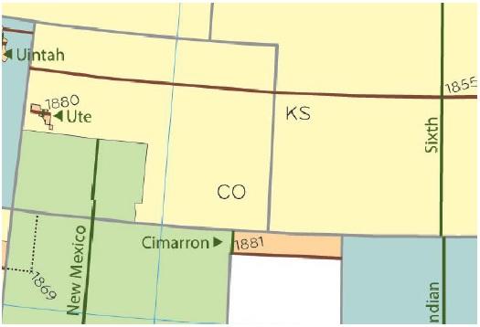
County Boundaries and Survey Areas
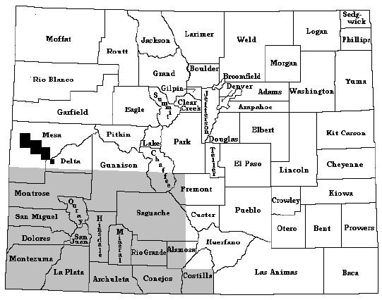
Addendum 13-B, Typical Measurement Units and Conversions
Below is a listing of commonly used measurement units and their conversions that can be found in Colorado legal descriptions.
Measurements of Length
1 foot = 12 inches
3 feet = 1 yard
1,760 yards = 1 mile
5,280 feet = 1 mile
2.54 centimeters = 1 inch
39.37 inches = 1 meter
3.281 feet = 1 meter
1,000 meters = 1 kilometer
Public Land Survey System Measurements
7.92 inches = 1 link
25 links = 1 rod
16.5 feet = 1 rod
100 links = 1 chain
4 rods = 1 chain
80 chains = 1 mile
320 rods = 1 mile
Measurements of Area
144 square (sq.) inches = 1 sq. foot
43,560 sq. ft. = 1 acre
160 sq. rods = 1 acre
16 sq. rods = 1 sq. chain
10 sq. chains = 1 acre
640 acres = 1 sq. mile
36 sq. miles = 1 township
1 sq. mile = 2.59 sq. kilometers
Measurements of Angles
60 seconds (") = 1 minute (')
60 minutes = 1 degree (o)
360 degrees = 1 circle
Addendum 13-C, List of Abbreviations
Below is a listing of abbreviations that are recommended in rewriting legal descriptions. All abbreviations will be given capital or lower-case letters the same as would be proper if the spelling were to be completed.
| Term | Abbreviation |
|---|---|
| Abstract | Abstr. |
| Acre | A.; Ac. |
| Addition | Addn.; Add. |
| Adjoining, Adjacent | Adj. |
| Also known as | A.K.A. |
| Amended | Am. |
| And Others | Et.Al.; et.al. |
| And Spouse | Et.Ux. |
| Angle | Ang.; < |
| Assessor(s) | Ass'r(s). |
| Avenue | Ave. |
| Beginning | Beg. |
| Between | Bet. |
| Block | Blk. |
| Book | Bk. |
| Bound, Bounded | Bd. |
| Boundary | Bdy.; Bdrs. |
| Building | Bldg. |
| Center | Ctr.; C. |
| Center Line | C.L.; C/L |
| Central Angle | C/A |
| Chain | Ch. |
| Commence, Commencing | Com. |
| Containing | Contg. |
| Continue | Cont. |
| Continuing | Contn. |
| Continued | Contd. |
| Corner(s) | Cor(s). |
| Correction | Corr. |
| Curve | Cv. |
| Dedication | Ded. |
| Degree | o or Deg. |
| Description, Described | Desc. |
| Diagonal | Diag. |
| Diameter | Diam. |
| Distance, District | Dist. |
| Easement | Esmt. |
| East | E. |
| Easterly | Ely. |
| Established, Estimated | Est. |
| Except | Ex.; Exc. |
| Filing | Flg. |
| Following | Fol. |
| Foot, Feet | Ft. |
| Fraction(al) | Fr(l). |
| From | Fr. |
| General Land Office Survey | G.L.O. |
| Government Lot | Gov't Lt. |
| Highway | Hwy. |
| Horizontal | Hor. |
| Inch(es) | In(s). |
| Including, Inclusive | Incl. |
| Incorporated | Inc. |
| Interest | Int. |
| Intersection | Inters. |
| Irregular | Irreg. |
| Left | Lt. |
| Line | Ln. |
| Link(s) | Lk(s). |
| Located, Location | Loc. |
| Lot | Lt. |
| Lying | Lyg. |
| Meridian | M.;Mer. |
| Mile | Mi. |
| Minutes | ' or M. |
| Miscellaneous | Misc. |
| More or Less | M/L |
| North | N. |
| Northeast | NE. |
| Northeasterly | Nely. |
| Northerly | Nly. |
| Northwest | NW. |
| Northwesterly | Nwly. |
| Number | No. |
| One half | 1/2 |
| One fourth | 1/4 |
| Original | Orig. |
| Page(s) | P.(PP) |
| Parallel | //; Par. |
| Place | Pl. |
| Point or Part | Pt. |
| Point of Beginning | P.O.B. |
| Point of Curvature | P.C. |
| Point of Ending | P.O.E. |
| Point of Tangency | P.T. |
| Portion | Ptn. |
| Principal | Prin.; P. |
| Private Claim | P.C. |
| Quarter | Qtr.; 1/4 |
| Radius | Rad. |
| Railroad | R.R. |
| Railway | Rwy. |
| Range(s) | R(s). |
| Reserve | Res. |
| Resubdivision | Resub. |
| Right | Rt. |
| Right of way | R/W; ROW. |
| Rods | Rds. |
| Running | Rng. |
| Said | Sd. |
| Seconds | " ; S. |
| Section(s) | Sec(s). |
| South | S. |
| Southeast | SE. |
| Southeasterly | SEly. |
| Southerly | Sly. |
| Southwest | SW. |
| Southwesterly | SWly. |
| Square | Sq. |
| Street(s) | St(s). |
| Strip | Stp. |
| Subdivision | Sub. |
| Thence, Then | Th. |
| Town | T. |
| Township(s) | Tp(s). |
| Tract | Tr. |
| Undivided | Und. |
| Unincorporated | Uninc. |
| Variation | Var. |
| Village | Vill. |
| West | W. |
| Westerly | Wly. |
| Whence | Wh. |
Introduction
Maps are the foundation of a good assessment system. Maps indicate parcel size, shape, location, and the relationship of the parcel to applicable features that affect market value.
Assessment maps simplify identification of each parcel within the county through the use of a parcel identification number. The parcel number, which is a numerical expression of a parcel legal description, provides a consistent and manageable method of representing sometimes lengthy legal descriptions.
Tax maps are at least 4,000 years old. The British Museum contains a series of clay tablets dating back to 2300 BCE. The tablets are inscribed with land surveys that were used for taxation purposes.
The Colorado assessment mapping and parcel numbering system was designed by the Colorado Tax Commission (now the Division of Property Taxation) in conjunction with the Colorado Division of Commerce and Development, the United States Geological Survey, and other interested parties. The purpose of the system was to promote a uniform mapping and parcel identification system statewide.
Statutory References
Colorado statutes require that assessors have accurate, up-to-date maps:
Maps of parcels of land in the county.
(1) Prior to January 1, 1981, each assessor shall prepare and maintain full, accurate, and complete maps showing the parcels of land in his county. The maps shall include a master county index map, together with applicable township, section, and quarter-section maps, depending on density. Guidelines shall be established by the administrator to produce uniformity throughout the state. The guidelines shall include the definition of a parcel, the development of a parcel numbering system, map size, map scale, and suggestions for minimum information to be plotted.
(2) In fulfilling the duty imposed upon him by subsection (1) of this section, the assessor may employ other mapping resources or maps available to him.§ 39-5-103.5, C.R.S.
Duties, powers, and authority.
(1)(d) To approve the form and size of all personal property schedules, forms and notices furnished or sent by assessors to owners of taxable property, the form of petitions for abatement or refund, the form of all field books, plat and block books, maps, and appraisal cards used in the office of the assessor and other forms and records used and maintained by the assessor and to require exclusive use of such approved schedules, books, maps, appraisal cards, forms and records by all assessors to insure uniformity . . . .
§ 39-2-109, C.R.S.
This chapter of the ARL Volume 2, ADMINISTRATIVE AND ASSESSMENT PROCEDURES MANUAL, provides the statutorily required guidelines for county maps and mapping programs.
Definitions of Basic Mapping Terms
Cadastral Map - A cadastral or tax map is a drawing of one or more segments of land showing the boundaries of subdivisions of land and the areas of individual tracts for the purposes of describing and recording land parcels. It is a graphical representation of a portion of the earth’s surface, on a flat surface. It shows the relative size and position of the land with respect to other properties, roads, highways, and major topographic features.
Tax Area (Tax District) - A geographic area where all properties are served by the same taxing entities.
Taxing Entity (Taxing Jurisdiction, Special District) - A political body which has the authority to levy for property tax, such as a school district, fire district, city, county, etc.
Parcel Identification Number - A parcel identification number is a composite of numbers representing a specific defined area of real estate on an assessment map.
Parcel - A parcel is a defined, single unit of real estate.
Contiguous Parcels - Contiguous parcels are adjoining parcels, under a common ownership and within the same tax area.
Uses and Advantages of a Mapping System
Assessment maps with parcel numbering provide a physical inventory listing of land within the assessor’s jurisdiction. Maps provide an excellent tool to verify that all taxable real estate appears on the tax roll. Through the inventory listing, omitted property and double assessed property can be easily discovered. Accurate assessment maps provide a method to locate overlapping parcels and to discover other legal entanglements. The system is a positive control measure, making property easier to locate and identify.
Another benefit of an accurate mapping system is that maps can be used to depict land use, neighborhoods, economic areas, sales data, assessment values, school or other taxing entity boundaries, legal descriptions, or any other desired compilation of assessment information. Sales data and neighborhood maps are essential in the development of plans for appraisal.
Establishing uniformity throughout the state enables other parties besides the assessor to make use of county maps without having to understand different mapping systems.
County commissioners, school boards, street and highway departments, taxing entities, private industry and individuals, and planning and zoning boards are examples of parties that can benefit from a uniform mapping system. Duplication of maps for sales data field work, land use studies, identifying land value, and for sale to anyone desiring the map, is easily and inexpensively accomplished. A parcel numbering system is the link between computerized assessment information about a property and the property’s location on the county map.
The maps are helpful when developing plans for the county. For example, when planning for a new road or sewage disposal, location and identification information for the area can be obtained simply by looking at the map. A property having basically one use is not apt to be split and put into different zoning districts when maps are utilized for zoning. In land-use studies and programs, each parcel could be color coded as to its use. Color-coding would make it easy to determine, for example, the number of motels or other specific businesses in the county and their locations.
By establishing and maintaining a map and parcel numbering system, the task of listing all real estate in the county becomes a simplified process. This method of data control simplifies the use of computerized assessment systems for sorting, computing, and distributing values and taxes. An effective filing system results when all appraisal records, maps, and computer data are indexed by parcel number.
Permanent parcel numbers reduce errors because it is easier to copy and check a 14-digit number than a lengthy legal description. The parcel number can be used as a numerical control system for either manual or automated systems.
A permanent parcel number system has the advantage of saving time in the performance of routine office work so that more time may be devoted to the assessor's task of determining the value of property.
Both the legal description and parcel number should be used on tax bills, notices of valuation, and the warrant. The parcel number is never to be used as a substitute description for a taxpayer’s real estate legal description.
Mapping Costs
The cost of a conventional mapping program will vary greatly depending on a number of items:
- County size
- Number and type of properties in county
- Accuracy and completeness of assessor’s records
- Availability of microfiche (subdivision plats, deeds, mineral plats)
- Availability of U.S. Geological Survey quadrangle maps
- Amount of state or federal land in the county
- Availability of county right-of-way information
- Extent of mapping devoted to mining claims and severed minerals
Additional costs will have to be considered if computerized mapping methods and GIS systems are to be incorporated into the mapping programs.
To substantiate costs for a mapping program, contact surrounding counties that have ongoing mapping programs. They should be able to provide information on start-up costs and any potential problems in setting up a mapping program.
The total cost of mapping can possibly be shared with other county agencies, such as the county planning department, depending upon whether these agencies have a need for the same mapping program.
Mapping Contracts
Each county must make a decision to either develop an in-house mapping program or to contract for the required professional services. If the decision is made to contract for mapping services, certain topics are important in developing and monitoring the contract.
Development of Request for Proposal
The initial step in the contractual process is development of the request for proposal (RFP). The RFP gives all prospective bidders general information about the mapping project, specific project specifications, and documentation requirements to be submitted by the bidder. The following checklist provides the minimum items to be included in an RFP:
- Project Specifications
- General scope of mapping services required
- Bid proposal packages developed during preliminary survey
- Work & delivery schedules & provisions for progress reports
- Insurance bonding requirements
- Performance bonding requirements
- Compensation requirements
- Work restrictions
- Penalties for non-timely completion of project
- General Information and Instructions to Bidders
- General county information
- County size (in square miles)
- Population
- Estimate of the total number of parcels to be mapped
- Name, address, and telephone # of project contact person
- Project timing estimate
- Final bid acceptance date
- Anticipated contract awarding date
- Time estimate to complete contract requirements
- Additional special scheduling instructions
- Special instructions/clarifications to specifications:
- Special mapping scales
- County data to be supplied to mapping contractor
- Additional work, not covered in project specifications
- Training to be conducted by contractor
- Bid requirements concerning format, forms, copies, etc.
- List of responsibility for interpretation of bid specs
- List of rights reserved in accepting or refusing bids
- General county information
- Documentation Requirements
- Bidder qualifications and references
- Staffing estimates to complete project
- Equipment needed to complete project
- Bidder's estimate of total project cost
- Qualifications & references for any subcontractors to be used
- Schedule showing time allotted to each phase of project
- Cost of any extra services not called for in the specs
Mapping Contractor Selection Process
Selection of a contractor should not be based on cost alone but should consider other aspects such as the following:
- Experience and competence of the bidder
- Quality of similar work completed by the bidder
- Nature and size of the bidder’s organization
Any firm or person that appears to have the personnel, material, and financial resources to successfully complete the project as specified should be considered. A good rule is to award the contract to the firm or person that submits the lowest and best bid.
After the contractor has been selected, the final mapping contract must be drafted and signed. The duties, obligations, and responsibilities of both the county and the contractor must be explicitly set forth in the contract.
Because the contract is a binding agreement between both parties, it is important that the project specifications, general information, bidder instructions, documentation requirements, and contractor bid proposal be made part of the contract.
NOTE: It is recommended that the final contract be reviewed by the county attorney and approved by the county commissioners.
Mapping Contract Monitoring
The designated county project director should monitor the mapping project throughout its duration. The monitoring process should include the following:
- Coordinate the flow of county data to the contractor.
- Keep the mapping project on schedule through review of periodic monthly reports.
- Check the quality and completeness of the finished product.
- Review specific phases of the project to see if project specifications and special scheduling are adhered to by the contractor.
- Provide proper and timely distribution of the finished product.
Mapping Specifications
The procedures for starting and maintaining a uniform mapping program encompass the following:
- Organization and preliminary work
- Drafting requirements
- Drafting procedures
- Edits and corrections
- Parcel number assignment
- Map filing
- Map maintenance
Mapping Organization and Preliminary Work
It should be determined how many maps are to be made and to what scale the maps are to be drawn. Township, section, quarter-section, and high density maps have specific recommended scales. A county map should be marked to indicate the areas to be mapped and the scale to be used. This map can also be used as an index of work completed.
An exact starting point should be established. All work should progress from this starting point to eliminate the possibility of overlooking parcels that overlap from one map to another and to ensure that the maps will join together accurately.
Any data common to all base maps, such as north arrow, graphic scale, county index map, township index map, county name, and revision block, can be pre-printed on a clear film (that is adhesive on one side) and applied to the Mylar base. Other methods are to photograph the common data into the film or print the data on the Mylar sheets. Both methods will add cost. If time and personnel are plentiful, these items can be manually drawn on each separate base map.
Standard specifications for maps are as follows.
Ink
Only ink that will adhere to plastics or drafting films is acceptable.
Film
Double matte Mylar film with a thickness of 0.004 of an inch. Mylar can be purchased by the roll or precut.
Sheet Size
A 32" high × 36" wide sheet size will accommodate most maps and still allow 2" for punching holes on the left side of the map for a hanging file.
Map Scales
The following map scales are recommended:
- Township Map (1 inch represents 1,200 feet)
- Section Map (1 inch represents 200 feet)
- Quarter-Section Map (1 inch represents 100 feet)
- High-Density Map (1 inch represents 50 feet)
Research indicates that the “breaking” point (conversion) for pulling a section from the Township map (1"=1200') and creating a new Section map (1"=200') occurs when it becomes necessary to plot 7 to 10 acre parcels. The breaking point from section (1" = 200') to quarter-section (1" = 100') occurs when it becomes necessary to plot 2 to 5 acre parcels, and in towns and cities which have 25 to 60 foot wide lots. The high density scale (1" = 50') is utilized to adequately portray areas that are densely parceled, such as townhouse or condominium projects. Good judgment should prevail at all times in the manner of scale selection and parceling in order to maintain consistency within the assessment mapping system. Scales other than those listed above must be approved by the Property Tax Administrator.
Line Weights and Symbols
If symbology is needed other than that listed below, it is recommended that the assessor use the standardization set up for the symbols needed. If the symbols are topographic, use the U.S. Geological Survey standard symbols. If the symbols are for industry, such as an oil company, use the standards set up by that particular industry, etc. Good drafting techniques and judgment should be used on line weights not covered below. Line weights and symbology are as follows:
| Symbol | Pen Size |
|---|---|
Rivers, creeks, and streams  | OO |
Lakes and reservoirs  | OO |
Highway and road rights-of-way  | OO |
Railroad  | OO |
Railroad right-of-way  | OO |
Canal or ditch right-of-way  | |
State line  | 4 |
County line  | 4 |
Township and Range line  | 3 |
Section lines  | OO |
Subdivision boundaries  | 3 |
Block boundaries  | 2 |
Lot and parcel lines  | 2 |
City limit lines  | 2 |
Ambiguous description  | OO |
Taxing jurisdiction boundary lines  | 3 |
Forest boundaries  | 2 |
Parcel boundaries where needed to clarify the boundary limits  | 3 |
Use for the division of lots  | |
Mining claims  | |
Tie bars  | |
Platted block number  | |
Assigned block numbers  | |
Assigned parcel number  | |
Assigned number for improvement only  | |
Severed mineral rights (interest) should be denoted by putting (S.M.R.) below the parcel number or where space permits  | |
Quarter-section numbering sequence within a section  | |
Division of Property Taxation State Assessed  |
Leroy Lettering Guides
It is difficult to establish comprehensive guidelines for all lettering sizes and design. Therefore, good drafting techniques and judgment should prevail on sizes and designs not covered below. If a county uses additional lettering guides, a documentation manual should be developed as a reference for future map maintenance.
| Description | Leroy Guide | Pen Size | |
|---|---|---|---|
| Legal description (lower right-hand corner of map) | 175 (vertical caps.) | 2 | |
| (upper left-hand corner, reading from bottom to top of map) | 100 (vertical caps.) | OO | |
| Sheet number identification (lower right-hand corner of map) | 500 (vertical) | 5 | |
| (upper left-hand corner, reading from bottom to top of map) | 175 (vertical) | 2 | |
| Adjoining sheet descriptions (all 4 edges of map | 175 (vertical upper and lower case) | 1 | |
| Assigned and platted (block numbers) | 140 (vertical) | 1 | |
| Street name | 140 (vertical upper and lower case) | 1 | |
| Subdivision name | 140 (vertical caps.) | 1 | |
| Platted lot number | 100 (vertical) | OO | |
| Assigned parcel number | 100 (vertical) | O | |
| Notation within a quarter section on a Township map, stating that a separate map of that section has been made. | 125 (vertical caps.) | 2 | |
| Notation within a quarter section on a Township map, stating that a separate map of that quarter section has been made. | 120 (vertical caps.) | O | |
| Notation within a quarter section on a section map, stating that a separate map of that quarter-section has been made. | 350 (vertical caps.) | 4 | |
| Notation within a high density area on a quarter-section map, stating that a separate map of that high density area has been made. | 350 (vertical caps.) | 4 | |
| Mining claims name and number | 140 (vertical upper and lower case) | 1 | |
| Water courses, such as rivers, canals, creeks | 100 (slant upper and lower case) | OO | |
| County township code index map | County name | 425 (vertical caps.) | |
| Township code numbers | 200 (vertical) | 3 | |
| Actual township and range numbers | 120 (vertical caps.) | O |
Mapping Drafting Requirements
The use of drafting tape should be kept to a minimum. It should be used only on boundaries that change frequently. Use of borderlines on the maps is optional. Every base film should have a light line just inside the map edge for ease and consistency of trimming the paper prints after reproduction.
Each map should have a north arrow, graphic scale, county index map, township index map, county name, and revision block on the left side of the sheet. There should be a 2" margin on the left side of the sheet for binding and for punching holes in the films for a hanging file.
Each map should be labeled in the lower right-hand corner and the upper left-hand corner with the proper identifying numbers and legal descriptions. In the lower right-hand corner of the map, there should be a notation as to the highest parcel number used within the unplatted areas. The tax area number or identification should be shown on the tax area boundary line. Unsurveyed land should be shown with a dashed line and labeled with the word “unsurveyed.”
The following items shall be shown on the maps:
- Section, township, and range numbers
- Addition or subdivision names
- Legal block numbers
- Lot numbers
- Lot, street, road, and highway dimensions
- Patented mining claims (names and patent numbers)
- Assigned township number
- Assigned block numbers
- Three-digit parcel number
- Ambiguous descriptions shown and noted
- Bearings and exact dimensions of metes and bounds parcels
- City limits
- County lines
- Property ownership lines
- Subdivision and addition boundaries
- Tax area boundaries
- Streets and names
- National and state forest boundaries
- Highway and road rights-of-way
- Highways, roads, numbers designating Federal, State, or local (names and boundaries)
- Railroads and/or right-of-ways
- Creeks, rivers, ditches, lakes, and any other bodies of water (names and boundaries)
- Highest parcel number used
- Notation that a map within a map has been made
- Map number to identify adjoining township, section or quarter-section maps (show on all four edges of map)
- Tie bars for ownership
- Use of public property, whenever known (courthouse, library, school, national park)
The following information is not mandatory for the primary purpose of the maps. However, such information could be valuable to the assessor and other parties, and may be added at some future date at an additional cost:
- Areas of land parcels
- Utility easements and other private rights-of-way
The following mapping source documents should be used in your mapping program:
- United States Geological Survey 7-1/2' and 15' quadrangle maps
- General land office plats and supplements
- Bureau of Land Management plats for oil, gas, and other minerals
- Department of Transportation maps (state and county)
- Aerial photos (if available)
- Subdivision, addition, and town plats
- Legal description of county road rights-of-way
- Legal description of all ditch and canal rights-of-way
- Legal description of all railroad rights-of-way
- List of all county-owned property by legal description
- County block books and land books
- Complete legal description of all parcels of land in the county (deeds)
- Legal descriptions and maps showing the boundary of each taxing entity
- State township four-digit code map, sample provided in packet
Some possible map sources include:
United States Geological Survey
United States Geological Survey Website
Phone: 888-275-8747
United States Department of Interior
Bureau of Land Management
Colorado State Office
2850 Youngfield Street
Lakewood, Colorado 80215
Bureau of Land Management Website
Phone: 303-239–3600
Mapping Drafting Procedures
Preliminary work should be done lightly in pencil on the films, then inked or mocked-up on paper, and then traced onto the film. Permanent data may be put on one side of the film and the data more frequently changed on the other side; or all of the data may be put on one side. The advantage of having permanent data on one side of the film and data more frequently changed on the other side is ease of correction.
The first sheet to be drafted should be a general explanation sheet. This sheet should show the 14-digit parcel numbering sequence, explaining what the numbers represent and how they are tied to a parcel of land.
In addition, a demonstration township map (not to scale) with numbered sections and one section broken into quarter-sections with assigned numbers should be completed. It should have a legend defining the symbology used and should show any other information needed to explain the mapping and parcel numbering system. A sample map (Example Map II) is available on request.
The first map to be drafted should be a map of the respective county showing the state's assigned township numbers, actual township and range numbers, adjoining county names, county seat, and a title. The scale of this map can be adjusted to fit on a 32" × 36" piece of film so it will be compatible with the other maps. A sample map (Example Map I) is available on request.
The next step in the process is the drafting of the township, section, or quarter-section maps as needed. Sample maps (Example Map IV and Example Map V) are available on request. The legal descriptions for each parcel should be extracted from the assessor’s administrative system. This information could be produced by listing schedule numbers from appraisal records by township and range. If the computer system does not have this capability, the hard appraisal records may be used. After the descriptions are extracted, they should be sorted according to township, range, and section numbers. The source documents, listed in Mapping Drafting Requirements, should be utilized to obtain the minimum data required, which is also detailed in the section Mapping Drafting Requirements.
Severed mineral rights should be labeled on the maps by lettering S.M.R. within parentheses. This lettering should be located underneath the parcel number where practical. This lettering means that minerals on this parcel are severed and indicates that a mineral interest file has been set up.
When an owner has acquired parcels that are contiguous, the descriptions may be put on the same computer record; one parcel number may be assigned to the several parcels that are contiguous. However, contiguous parcels may receive a separate parcel number if they are divided by a tax area boundary.
Mapping Discrepancies and Corrections
As the map maker plots the descriptions, any ambiguous descriptions should be researched as soon as they are discovered. The mapper should verify that the legal descriptions were correctly listed and that source documents were not overlooked during the initial research.
If research is necessary, the county clerk’s records, abstract companies, and property owners are reliable sources.
Upon receipt of reliable data, the map maker can correct the maps. When reliable data is unavailable, discrepancies should be marked with a notation indicating ambiguous description (A.D.).
Parcel Number Assignment
After all legal descriptions and all tax area boundaries have been drafted on the maps, a parcel number should be assigned to each parcel within the county. This identifier serves as an ownership and record control number. The parcel number should be used on all assessment records.
Procedures on developing and assigning parcel identification numbers can be found in a later part of this section.
Map Filing
Tax maps are official records of assessment data and are subject to constant use. County and city offices, title and abstract personnel, real estate brokers, surveyors, engineers, and others, are interested in this information. A set of prints should be conveniently accessible to the public.
Base Mylar maps should never be accessible to the public and should be stored in a fireproof cabinet. Base maps should be used only to reproduce additional copies or when updates are required. The base Mylars represent a considerable investment and if damaged, lost, or destroyed, would seriously hamper the work of the assessor. As a safeguard, base maps should be microfiched periodically and stored at an off-site location.
The prints to be used by the public can be stored in a binder for protection. The base maps can be reduced to a more usable size by a professional reproduction company. For the base Mylars, a hanging type file is recommended because it can hold up to 600 originals and any map can easily be pulled from the cabinet without disturbing the other maps. Flat files are not recommended because the ink can wear off double matte Mylar from constant use.
Mapping Maintenance
Once completed, it is essential that the assessment maps and all related assessment records be kept up-to-date. This requires constant vigilance on the part of the assessor. Assessment maps soon become outdated and much of the original value and investment will be lost unless all changes and corrections are made on a regular basis; preferably weekly or at least monthly.
This basic assessment map system is designed for flexibility and growth and requires constant maintenance. The maintenance consists of updating the maps when boundary changes occur. This includes but is not limited to the following:
- Changes in taxing entity boundaries due to an annexation, inclusion, or exclusion
- Creation of a new taxing entity
- Sale of real property improvements only
- Condominium project development
- Severed mineral interests
- Change of tax status of property
- Property splits and mergers
- New highway rights-of-way
Maintenance of the maps involves correction and constant improvement of the maps from new or more accurate survey data, when available.
The source data for maintenance of the maps are:
- Recorded property transfers
- Recorded subdivision filings and plats
- Recorded licensed surveys and other recorded maps
- Highway and road surveys, government surveys, and miscellaneous types of surveys
When a portion of a property is transferred or a merger occurs, a copy of the deed, including the original parcel number(s), should be given to the mapper. The mapper should then update the assessment map and assign new parcel numbers as required.
As subdivision, condominium, and townhome plats are filed, the mapper should plat those developments on layout sheets to standard scales to assure they fit properly with existing property boundaries. Complicated metes and bounds property splits should also be platted on a layout sheet. New parcel numbers should be assigned to the subdivision lots and to the parcel splits. Also, if new highway or other surveys or taxing area boundaries split a property, new parcel numbers should be assigned. The master map should then be revised and new prints run of the updated maps.
NOTE: Documents executed and recorded on or after July 1, 1992, which contain a newly created legal description must include the name and address of the person who created the legal description, § 38-35-106.5, C.R.S. This provision of the law can assist mappers if discrepancies occur.
All recorded documents that cause a change in the assessment maps should be forwarded to the mapper. This flow of information guarantees that accurate information will be reflected on the assessment maps.
The county planning department and/or county commissioners should make an effort to standardize subdivision plat filings to one of the scales recommended for county maps in this section. Use of a standardized scale will enable the mapping department to save time in plotting the subdivisions onto county maps.
Available Typical County Maps
The following example maps are available upon request:
Map I - Example County Township Code Map
Map II - General Mapping Legend and Explanation Sheet
Map III - Example Township Map (scale 1" = 1200')
Map IV - Example Section Map (scale 1" = 200')
Map V - Example Quarter-Section Map (scale 1" = 100')
Computerized Mapping and GIS
Computerized mapping systems are available that will digitize legal descriptions and other cartographic data and display them as points, lines, topographical chains, and polygons. The mapping data is stored in a database and can be easily accessed and edited. Another provision of computer-assisted mapping is automatic error detection and correction parameters. Depending on the mapping tolerance selected, legal descriptions can be plotted and any traverse error corrected or eliminated.
A Geographic Information Systems (GIS) enables the integration of digitized maps with other data having a relationship to location. It is a natural fit for the assessor’s office and allows for information such as sales data, property characteristics, classification, and valuation, to be displayed and analyzed according to its location.
For additional information on computerized mapping and GIS, refer to Addendum 14-A, Guidelines for Assessor Digital Parcel Mapping.
Computer Plotting Software
Plotting software is available for individuals who need to determine shape, area, and accuracy of legal descriptions, without the manual effort involved in plotting a legal description. The software allows the entry of a legal description to obtain a plot on a graphics computer screen or a graphics compatible printer. The plotting software is produced by several companies and should be available at any computer software store.
Specifications for Parcel Numbering
Permanent Parcel Numbering System
An example of a parcel number is shown in Figure 1.
Each parcel of real estate is represented by a 14-digit series of numbers. The first two numbers represent the county. Each of the 64 counties has been assigned a numerical code according to its alphabetical sequence from “01” for Adams County through “63” for Yuma County. (The county number for the City and County of Broomfield is “80.”)
The next four numbers apply to a particular township within the state. Each township in the state of Colorado has been assigned a 4-digit code number. The upper-right-most northeasterly township was assigned number 0001. The townships are numbered in tiers from east to west in the first tier and from west to east in the second tier and so on throughout the entire state. All of the established numbers are odd, 0001, 0003, 0005, etc., continuing through to number 6193 in the southwest corner of the state. The numbering system was established to allow for the insertion of even numbers for errors that may be revealed in the future without destroying the system. A map showing the numbering system is provided in the manila envelope.
Of the next set of three numbers, the first two represent the actual section number, and the third represents the assigned quarter-section number. The northeasterly quarter-section being numbered “1,” the northwesterly quarter-section being “2,” the southwesterly quarter-section being “3,” and the southeasterly quarter-section being “4.” A set of these three numbers, such as 054, indicates the southeast quarter of section 5. Please refer to Figure 2.
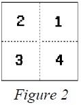
Continuing from left to right in the parcel number, the next two digits are block numbers assigned to platted blocks. Digits “00” always indicate unplatted areas. Where there are platted blocks, each block is assigned a number sequentially regardless of the block number assigned on the subdivision plat.
The last three digits are assigned to a parcel. These numbers are assigned consecutively starting with “001” for each block of subdivided land, and also start with “001” for each parcel of non-subdivided land per map.
The parcel number is tied to the legal description of the total property under a common ownership. The parcel number changes only as a result of a change in the legal description.
Method of Assigning Parcel Numbers
Township Maps
The parcel numbering on a township map begins in the northeast corner of the township in section 1, numbering each parcel in that section using the same pattern as the sections are numbered within a township, starting with the number “001” and continuing consecutively until the last section of the township has been numbered. The pattern used for numbering sections within a township applies. A sample map (Example Map III) is available upon request.
Section Maps
The parcel numbering on a section map uses the same pattern as the sections within a township, beginning with “001” in the northeast corner of the map and continuing until the last parcel at the bottom of the map has been numbered. If there are platted blocks, they should be assigned block numbers starting with “01” using the same pattern previously mentioned. Within each block, the parcel numbering should start over with “001,” beginning in the upper right-hand parcel and continue in a counter-clockwise direction. A sample map (Example Map IV) is available upon request.
Quarter-Section Maps
The parcel numbering on a quarter-section map begins in the northeast corner of the map using the same numbering pattern as the sections within a township. This pattern continues to the bottom of the map. Each block should be assigned a number starting with “01” and should be numbered using the same pattern as mentioned above. The parcel numbering begins with “001” for each block beginning in the upper right-hand corner of the block and continues in a counter-clockwise direction. Within each block, the parcel numbering starts over with “001.” A sample map (Example Map V) is available upon request.
If there are parcels of land within a quarter-section map that are not part of a platted area, they should be numbered using the same numbering pattern as the sections within a township; this numbering begins with “001” and continues to the bottom of the map. Sample maps (Example Map IV and Example Map V) are available upon request.
High Density Maps
High density maps should be used only where absolutely necessary. High density maps should be parcel numbered as if they were a full quarter-section map, using the pattern for numbering as mentioned above for quarter-section maps. Addition and subdivision boundaries should be ignored when parcel numbering.
Contiguous Parcels Under Common Ownership
Contiguous parcels under a common ownership, within the same tax area, may be assigned one parcel number. Tie bars should be used to join these contiguous parcels.
The largest land area should be picked for the assignment of parcel numbers for parcels that overlap from one township into other townships, from one section into other sections, and from one quarter-section into other quarter-sections. The quarter-section designator is assigned based on the quarter section within which the largest land area of the contiguous parcel lies. Refer to Figure 3 for an example.
As shown in Figure 4, if the largest land area contains more than one full quarter section, assign the designator to the first quarter section within the counter-clockwise series. This procedure should be followed for each of the recommended map scales.
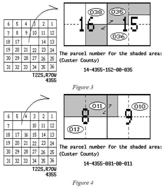
Parcel Number Creation
Using the information shown in Figure 5, the county is Custer (number 14), the complete parcel number to identify the parcel of land that falls in the northwest quarter of section 6 and the north half of section 1 is written:
14-4355-062-00-010
The number to identify the remainder of section 1 and the east half of the east half of section 2 is written as follows:
14-4353-013-00-001
For the remainder of section 2 the parcel number is:
14-4353-022-00-002
The parcel number to identify the remainder of section 6 is written:
14-4355-061-00-009
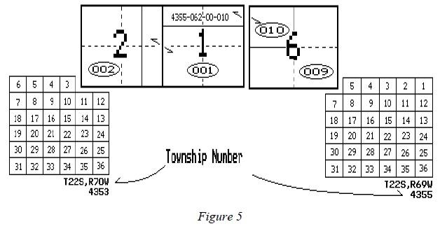
The block in Figure 6 is in Elbert County (number 20), the SW1/4 of section 27, township 7
south, range 64 west of the 6th P.M., the complete parcel number for identification of lots 2-4
and part of 5 is written:
20-2345-273-01-003
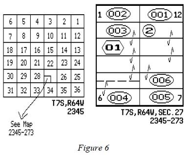
Sections 6 and 7 in Figure 7 are in Park County (number 47), township 8 south, range 76 west of the 6th P.M., the complete parcel number for identification of the parcel that falls in both sections is written as follows:
47-2487-064-00-011
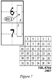
Sections 19 and 24 in Figure 8 are in Kiowa County (number 31), section 19 is in township 18 south, range 45 west; section 24 is in township 18 south, range 46 west of the 6th P.M.; the parcel number for the parcel that falls in both sections (different townships) is written as follows:
31-3871-193-00-002
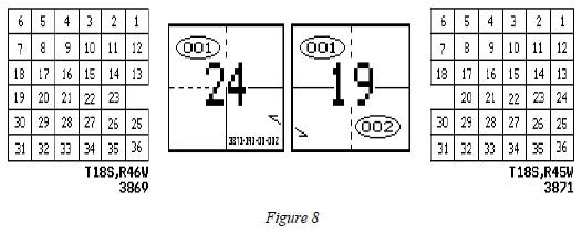
A tie bar should be used to indicate the property in section 24 has the same parcel number as that of section 19. Also, if space is available on the map of section 24, there should be a notation on that part of the parcel that falls on the map of section 19 indicating the complete parcel number.
Parcel Number Deletion
In certain circumstances, parcel numbers must be deleted and new parcel numbers created. Examples include:
- Split of property into two or more separately owned parcels
- Merging or combination of two or more parcels into one parcel
- Splitting of an existing parcel due to creation or change in a taxing entity’s boundary
Property Splits
If a property splits, the original number must be canceled and new numbers assigned using the next highest number for that map. Never use the original number again. Please refer to Figure 9.
Property Mergers
If properties are merged, the original parcel numbers must be canceled and a new number assigned using the next highest number for that map. Please refer to Figure 10.
NOTE: The board of county commissioners is authorized to eliminate interior lot lines or obsolete subdivisions in accordance with the requirements of § 30-28-139, C.R.S. When it does so, the county shall file for recording a notice of merger with the county clerk and recorder, and the notice shall constitute prima facie evidence that the requirements of the statute have been satisfied, § 30-28-139(3)(b), C.R.S. The merged parcels are subject to valuation as a single parcel as of January 1 following the board’s approval of the merger, § 30-28-139(3)(a), C.R.S.
Undivided Interest Numbering
An undivided interest is defined as an interest in property that cannot physically be identified as being distinct and separate from the interests of the other owners. The owner of an undivided interest owns an interest in the entire property, but no separate physical part can be identified as belonging to the owner exclusively.
One parcel identification number should be assigned to a parcel, except for severed mineral interests, regardless of the number of undivided interest holders.
NOTE: If improvements are located on the parcel, care should be taken to determine the ownership of the structures. Generally, the improvements carry the same ownership as the land. However, it is possible for one undivided interest holder to own 100% of an improvement. If the latter applies, a separate parcel identification number should be assigned to the improvement. Refer to Line Weights and Symbols in this chapter.
Property Split by Taxing Entity Boundaries
Any property that is split when a new taxing entity is created, or by a change in an existing taxing entity’s boundary, may have a new parcel number assigned to each portion of the parcel. The old parcel number may be deleted and a new number assigned using the next highest number for that map. Please refer to Figure 11.
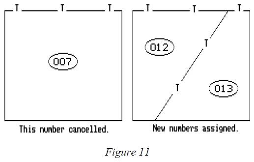
Condominium Numbering
Each condominium unit is assigned a separate parcel number. An arbitrary block number should be assigned to each building or group of units within each condominium filing. Please refer to Figure 12.
In Figure 12 there is one condominium filing, Greens Condominiums, containing three buildings (Building A, B, and C). Each building is assigned an arbitrary block number as shown. In the example, block number 01 is assigned to Greens Condominium building A, block number 02 is assigned to building B, and block number 03 is assigned for building C. Block numbers should be determined according to the parcel numbering sequence for that section or quarter section map. Parcel numbers should be assigned, beginning with parcel number 001, to each condominium unit. The first and last parcel number used per building should also be shown, Figure 13.
In Figure 13, each building contains 50 condominium units. Each of the 150 units is assigned a separate parcel number. In the example, Building A, Units 100 through 150 are assigned block 01, parcel numbers 001 through 050. Building B, Units 200 through 250 Building B are assigned block 02, parcel numbers 001 through 050. Building C, Units 300 through 350 are assigned block 03, parcel numbers 001 through 050. The distinction between units is made by assigning different block numbers.
Parcels designated as common areas by the condominium plat should be shown and numbered on the assessment map. Parcel numbers for a common area should have the notation C.A. after parcel number. If improvements exist on common area land, they may be assigned a parcel number with the assigned three-digit parcel number noted within a square.
To allow for changes in parcel numbers due to replatting or ownership changes, buildings containing more than 600 units should be assigned a new block number for each group of 600 units. Refer to Figure 14.
Figure 14 shows a single condominium filing with a single large condominium building containing 1200 condominium units. The first 600 units are assigned block number 01, parcel numbers 001 thru 600. The next 600 units are assigned block number 02, parcel numbers 001 thru 600.
Condominium ownership is the only situation where block numbers are assigned to a group of units rather than to actual property blocks.
Miscellaneous Items for Parcel Numbering
The various types of identification of other items covering highways, streets, utility rights-of-way, utility property assessed by the Division of Property Taxation, and exempt properties, are as follows:
- Easements, ditches, rivers, and streams are not assigned parcel numbers.
- Highways, streets, and roads should not receive a parcel number if dedicated and accepted by the city or county. If they have not been dedicated and/or accepted, the parcel should receive a parcel number in the same manner as any other land parcel.
- Rights-of-way considered as part of a public utility’s operating property are not assigned parcel numbers, but are shown with the notation “D.P.T.” (which stands for Division of Property Taxation assessed). Utility rights-of-way which are not utility operating property must receive a parcel number as any other land parcel. If necessary, contact the Division of Property Taxation, State Assessed Section to determine whether the right-of-way is an operating property.
- All other operating state assessed properties are assigned a parcel number and noted with the wording “D.P.T.”
- Exempt properties are assigned a parcel number and noted “Exempt.” For exempt properties, the last three digits of the parcel number may begin with 900 and continue forward.
- Patented mining claims should be assigned numbers in the same manner as other land parcels.
- Unpatented mining claims are exempt from taxation and should receive an “Exempt” parcel number as stated in bullet point 5 above.
When rivers, streams, or other bodies of water split a property into segments, a separate parcel number should be assigned for each segment providing the body of water is so described in the deed. When roads, highways, ditches, or streets split a property into segments, a separate parcel number should be assigned for each segment providing the road, highway, ditch, or street is accepted by dedication or the exclusion of these items are so noted by deeds.
Properties that are contiguous under a common ownership but are split by a county line or taxing jurisdiction boundary will require a separate parcel number for each segment that is severed from the whole. Before starting the parcel numbering, a work map should be made showing the taxing jurisdiction boundaries.
If an owner of a parcel of land adjoining a vacated street or alley has not received the title to the vacated land, then such land is assigned a parcel number. If the property reverts to the adjoining owner, it can be joined by a tie bar. The old number is canceled and a new number assigned to the two parcels of land that have been merged together as one parcel.
Exceptions to Parcel Numbering Specifications
Section 39-5-103.5, C.R.S., requires that all assessors maintain full, accurate, and complete maps showing the parcels of land in the county. Also contained within this statute is the requirement that the Division of Property Taxation establish guidelines for mapping uniformity throughout the state.
A written request to the Division of Property Taxation for approval to incorporate any special situations into the county mapping program not covered by these mapping and parcel numbering specifications is mandatory.
Summary
A good mapping system is the foundation for a good parcel identification system. The mapping system can be based on ground surveys or could incorporate computers, electronic map plotters, and satellite photography.
Colorado statutes require that all counties prepare and maintain a mapping system. These guidelines have been prepared by the Property Tax Administrator to aid the assessors in accomplishing this task.
To determine proper mapping costs, items such as county size, parcel count, accuracy of records, and availability of existing state and federal maps should be considered. Information on costs and potential problems can be obtained by contacting adjacent counties that have ongoing mapping programs.
A part of the mapping process is the assignment of parcel identification numbers. Each number is based on the legal description of the parcel and ownership status. With a parcel number, each property can be uniquely identified.
Written approval from the Division of Property Taxation must be obtained to incorporate any changes or special situations not covered in these guidelines.
Addendum 14-A, Guidelines for Assessor Digital Parcel Mapping
Introduction
The Guidelines for Assessor Digital Parcel Mapping were developed to provide uniformity in the creation and maintenance of graphic and tabular data. It is hoped this structure will benefit agencies that participate in data sharing. In the creation of the Guidelines for Assessor Digital Parcel Mapping for the state of Colorado, it is important to first look at the current requirements for assessment maps. The Property Tax Administrator is required by law to establish uniform guidelines for parcel mapping. The Division of Property Taxation, Department of Local Affairs, authored and published the ARL Volume 2, ADMINISTRATIVE AND ASSESSMENT PROCEDURES MANUAL, Chapter 14, Assessment Mapping and Parcel Identification. This document guides each county's parcel mapping effort so that across the state there is some uniformity in the maps. In addition, we have included an introductory section on the metadata standards developed by the Federal Geographic Data Committee. Metadata describes the content, quality, condition, and other characteristics of data.
There are some assumptions made in this document. It is assumed that the graphic data is stored in the North American Datum of 1983 (NAD83) values, and if possible, in the Colorado adjustment of that datum (NAD83/92). Since the parcel maps are reflective of data created by land surveyors, the unit of measurement is the U.S. Survey foot. The Federal Government has made the move to the meter as the Official Unit of Measurement, but inherent in most of the Geographic Information Systems (GIS) is the capability to transform data from one unit of measure to another, as well as from one mapping projection to another. Ideally, each county’s GIS will store its data in state plane coordinates in U.S. Survey feet, as defined in §§ 38-52-101 through 106, C.R.S.
Using ARL Volume 2, ADMINISTRATIVE AND ASSESSMENT PROCEDURES, Chapter 14, Assessment Mapping and Parcel Identification, as a guide, data can be broken down into four basic data types: lines, polygons, points, and text. Data concerning these four basic data types are detailed within this document. This document also covers survey control as an important area to be addressed.
Lines, polygons, points, and text can be generally stratified by one of five basic themes. Line requirements for assessor’s maps are detailed in ARL Volume 2, ADMINISTRATIVE AND ASSESSMENT PROCEDURES, Chapter 14, Assessment Mapping and Parcel Identification.
- Boundary data
- State boundaries
- County boundaries
- City and town boundaries
- Forest boundaries
- Taxing jurisdiction boundaries
- Hydrographic data
- Natural flowing water (rivers, creeks and streams)
- Stationary water (lakes and reservoirs)
- Man-made flowing water (canals and ditches)
- Landnet data
- Geodetic control
- Public Land Survey System (PLSS)
- Township, range, and section lines
- Parcel data
- Parcels
- Block boundaries
- Lot boundaries
- Subdivision boundaries
- Road rights-of-way (ROW) and road easements
- Ditch rights-of-way
- Canal rights-of-way
- Utility easements
- Mining claims
- Ambiguous legal descriptions
- Parcels
- Transportation data
- Physical roads (road centerlines and edges)
- Airports
- Railroads
NOTE: The above is not intended to be all-inclusive.
In the migration to a GIS, there are three additional line types that can be added to aid in connectivity and topology:
- Common ownership lines (rather than tie bars)
- Utility easement lines
- Right-of-way lines that are for graphic purposes only
These lines represent an apparent ROW when there is no deed to support it.
A linking feature, such as a centroid, can be added as a data management tool.
A number of factors influence the organization of themes in a geographic database, and they differ with each application. The attributes of the above list may be established as individual layers or combined and established as one layer. The key to establishing layers is to determine the data needs and how an agency will use the GIS. Attributes may be organized thematically by what they represent. For example, even though sewer piping and power lines are both linear features, their descriptive attributes may be quite different. The attributes associated with a sewer pipe may include its diameter, piping material, flow direction, date of installation, etc.; while attributes for power lines consist of wiring size and material, voltage, and other electrical data. Because their associate attributes differ significantly, the sewer lines and power lines should be stored as separate themes. Keep in mind, that once data is combined and established as a layer, it cannot be separated without significant manual manipulation. When attributes are established as individual layers, they can be combined as needed for each project; thus, the data is easier to manipulate. This can be a distinct advantage when processing specific requests or creating “custom” projects.
Attributes
An attribute is data about a map feature that is typically stored in a database format as a record. Four common types of attributes are detailed below. These include line, polygon, point, and text attributes.
Common Line Attributes
The GIS can store information about each line segment as attributes to each line segment. These attributes describe and define line segments. Graphic or tabular data can be created by querying the data sets. The line weights are defined in ARL Volume 2, ADMINISTRATIVE AND ASSESSMENT PROCEDURES, Chapter 14, Assessment Mapping and Parcel Identification. Color attribute standards should be developed and documented by each county. The following commonly used attributes for line features, although not a comprehensive list, are recommended.
- A unique identification number
- An attribute for the angle or bearing of the line segment
- An attribute for the distance of the line segment
- Attributes for storing curve information
- Radius
- Delta
- Tangent
- Arc length
- Which side of the line segment the curve is on
- An attribute for drawing the line segment in its proper symbology
- An attribute for the source of the line
- 5 = Global Positioning System (GPS)
- 4 = Coordinate geometry (COGO)
- 3 = Digitizing
- 2 = Scanning
- 1 = Other
- An attribute for the confidence of the positional accuracy of the line
- 5 = Highest confidence - 1 = Lowest confidence
- An attribute for the date when the line was created in the GIS
- An attribute for the date when the line was changed in the GIS
- An attribute for comments
Additional attributes, such as information as to who created the line segment, may be added for data management purposes.
Common Polygon Attributes
When the polygons are created in the GIS, a link between the graphic data and the associated tabular data must be established. This is accomplished by placing a feature, such as a centroid, within the polygon that contains attributes that can be linked to various tabular data bases. The attribute that links the individual polygon to its tabular data is a unique identification number, such as the 14-digit state parcel identification number or the schedule number. Information concerning the 14-digit state parcel identification number is located in ARL Volume 2, ADMINISTRATIVE AND ASSESSMENT PROCEDURES, Chapter 14, Assessment Mapping and Parcel Identification.
In addition to the unique identification number, other important polygon attributes include:
- An X-Coordinate for the linking feature
- A Y-Coordinate for the linking feature
- The 14-digit state parcel identification number
- The area of the lot/parcel
The areas generated in the GIS are based upon a mapping projection, and some manipulation must be done to generate ground or platted areas in the GIS. If the platted or deeded areas are known, it would be easier to store them as attributes for inquiry purposes. The area could also be stored in acres as an additional attribute. - A confidence factor for the area
5 = Highest Confidence - 1 = Lowest Confidence
The confidence on the “area” attribute should be determined based upon the source. For example, an area that came from a Subdivision plat or a deed would have a higher confidence than an area that came from a planimeter or was generated from the system. - An attribute for storing the layer information
- An attribute for the date when the polygon was created in the GIS
- An attribute for the date when the polygon was changed in the GIS
- An attribute for comments
As with the line features, data management attributes such as who created the polygon may be added.
Common Point Attributes
There are several cases where data will be stored as points rather than lines or polygons. These points have the following common attributes.
- A unique identification number
- An attribute for the state plane northing of the point feature
- An attribute for the state plane easting of the point feature
- An attribute for drawing the point feature in its proper symbology
- An attribute for the source of the point feature
- 5 = Global Positioning System (GPS)
- 4 = Coordinate geometry (COGO)
- 3 = Digitizing
- 2 = Scanning
- 1 = Other
- An attribute for the confidence of the point feature
- 5 = Highest Confidence - 1 = Lowest Confidence
- An attribute for the date when the point was created in the GIS
- An attribute for the date when the point was changed in the GIS
- An attribute for comments
Common Text Attributes
The Property Tax Administrator has published standards for map text in ARL Volume 2, ADMINISTRATIVE AND ASSESSMENT PROCEDURES, Chapter 14, Assessment Mapping and Parcel Identification. The text attributes that may be associated with each text feature include:
- A unique identification number
- Information about the text string
- The text string itself
- The size of the text
- The symbol it is drawn as
- An attribute for the date the text was created in the GIS
- An attribute for the date the text was changed in the GIS
- An attribute for comments
Data management attributes may be added to the text strings. However, unlike the attributes to line segments and polygons, there is very little intelligence to the attributes of text features.
Survey Control
Geodetic control and its ties to the section, township and range grids are critical to a GIS. For this reason, the attributes for the geodetic control layer and the Public Land Survey System have been identified so that the overall quality can be gauged. Geodetic control is the foundation of all digital mapping, and compliance with the National Mapping Accuracy Standards is a goal that can be achieved beginning with good ground control and good mapping techniques.
Typically, a landnet is generated from the U.S.G.S., 7.5 minute quadrangle. This data may be accurate to +/- 40 feet spatially, or it could be as much as a few hundred feet in error. While this is adequate enough to create a “picture” of what exists, it will not be to the level of accuracy required for all potential GIS data users. It is important for an entity to assess its accuracy requirements based on current and future GIS/mapping applications. While it may be less expensive to build a GIS dataset that has low absolute accuracy, this decision may limit the types of applications that can be deployed. For many assessor applications, other measures of accuracy, such as attribute accuracy and relative accuracy, may be as important as absolute accuracy.
The Colorado Department of Transportation created a statewide geodetic control network called the High Accuracy Reference Network (HARN). There are many projects underway across Colorado to densify the HARN in order to make it more useful locally. Counties may work with the state to densify the HARN within their boundaries. This will greatly improve the accuracy of the GIS graphic data. From this network the local land surveyors can generate information on section corners, including coordinates.
The attributes for these layers are as follows.
Common Geodetic Control Layer
- A unique identification number
- An attribute for drawing the monument at its proper symbology
- An attribute for the monument name
- An attribute for the agency who set the monument
- An attribute for the horizontal accuracy of the monument
- An attribute for the vertical accuracy of the monument
- An attribute for the latitude of the control monument
- An attribute for the longitude of the control monument
- An attribute for the ellipsoidal height of the control monument
- An attribute for the state plane northing of the control monument
- An attribute for the state plane easting of the control monument
- An attribute for the state plane zone of the control monument
- An attribute for the geoidal height of the control monument
- An attribute for the orthometric height of the control monument
- An attribute for the horizontal datum
- An attribute for the vertical datum
- An attribute for the section in which the control monument is located
- An attribute for the township in which the control monument is located
- An attribute for the range in which the control monument is located
- An attribute for the name of the U.S.G.S., 7.5 Minute Quad in which the monument is located
- An attribute for the date in which the monument was entered into the GIS
- An attribute for the date when the monument was last recovered in the field
- An attribute for the physical description of the monument
- An attribute for comments
Common Public Land Survey System Layer
- A unique identification number
- An attribute for the aliquot description of the monument
- An attribute for the section in which the monument is located
- An attribute for the township in which the monument is located
- An attribute for the range in which the monument is located
- An attribute for the principal meridian
- An attribute for the name of the U.S.G.S., 7.5 Minute Quadrangle in which the monument is located
- An attribute for the state plane northing of the monument
- An attribute for the state plane easting of the monument
- An attribute for the state plane coordinate zone of the monument
- An attribute for the horizontal datum of the monument
- An attribute for the confidence of the coordinate value of the monument
- 5 = Highest Confidence - 1 = Lowest Confidence
- An attribute for the source of the coordinates
- 5 = Global Positioning System (GPS)
- 4 = Coordinate geometry (COGO)
- 3 = Digitized
- 2 = Scanned
- 1 = Other
- An attribute for the master index number of the monument
- An attribute for the date when the monument was entered into the GIS
- An attribute for the date when the monument was last recovered in the field
- An attribute for the physical description of the monument
- An attribute for comments
Digital Data Management
GIS data organization and management is essential. To better manage the GIS data created from the parcel maps, parcel directory and layer naming conventions should be established.
An example of parcel directory and layer naming conventions is shown below. These are in compliance with the International Organization for Standards (ISO) standard concerning the 8.3 file naming conventions. The layers should be broken down by township, using the unique four-digit township numbering system as identified by the Division of Property Taxation in ARL Volume 2, ADMINISTRATIVE AND ASSESSMENT PROCEDURES, Chapter 14, Assessment Mapping and Parcel Identification. Each parcel layer should be broken down by sections, so there will be a maximum of 36 section layers in each township directory. The layers can also be stored as full or partial townships under the township directory if there is not enough parcel data to break it out to a section level.
The following outlines this structure for township 1234:
Directory: twp1234
Layers:
- s01_1234
- s02_1234
- s03_1234
- s04_1234
- s05_1234
- s06_1234
- s07_1234
- s08_1234
- s09_1234
- s10_1234
- s11_1234
- s12_1234
- s13_1234
- s14_1234
- s15_1234
- s16_1234
- s17_1234
- s18_1234
- s19_1234
- s20_1234
- s21_1234
- s22_1234
- s23_1234
- s24_1234
- s25_1234
- s26_1234
- s27_1234
- s28_1234
- s29_1234
- s30_1234
- s31_1234
- s32_1234
- s33_1234
- s34_1234
- s35_1234
- s36_1234
The following example shows how full and partial township layers would be named, again using township 1234:
Directory: twp1234
Layers:
- full_1234 - Full township layer
- part_1234 - Partial township layer
This is where one or more sections are broken out, and the naming convention outlined above is used, with a portion of a township remaining.
- n2_1234 - North half of a township layer
- s2_1234 - South half of a township layer
- e2_1234 - East half of a township layer
- w2_1234 - West half of a township layer
- nw4_1234 - Northwest quarter of a township
- sw4_1234 - Southwest quarter of a township
- se4_1234 - Southeast quarter of a township
- ne4_1234 - Northeast quarter of a township
The township layers should only be broken down to the quarter township level. If the data or source is less than a quarter township, it should be broken down into sections using the naming convention appropriate for the section layers.
Metadata Standards
Metadata or "data about data" describe the content, quality, condition, and other characteristics of data. Metadata are used to organize and maintain investments in data, to provide information to data catalogs and clearinghouses, and to aid data transfers. The Federal Geographic Data Committee (FGDC) approved the Content Standard for Digital Geospatial Metadata on June 8, 1994. Since that time, many organizations within and outside of the federal government have adopted the FGDC metadata standard and are using automated indexing and serving mechanisms to provide access to their holdings through the Internet. In addition, the GIS software vendor community has been very active in both the definition and adoption of the standards.
The objectives of the standard are to provide a common set of terminology and definitions for the documentation of digital geospatial data. The standard establishes the names of data elements and compound elements (groups of data elements) to be used for these purposes, the definitions of these compound elements and data elements, and information about the values that are to be provided for the data elements.
The standard was developed from the perspective of defining the information required by a prospective user to determine the availability of a set of geospatial data, to determine the fitness of the set of geospatial data for an intended use, to determine the means of accessing the set of geospatial data, and to successfully transfer the set of geospatial data. As such, the standard establishes the names of data elements and compound elements to be used for these purposes, the definitions of these data elements and compound elements, and information about the values that are to be provided for the data elements. The standard does not specify the means by which this information is organized in a computer system or in a data transfer, nor the means by which this information is transmitted, communicated, or presented to the user.
In addition to use by the federal government, the FGDC invites and encourages organizations and persons from state, local, and tribal governments, the private sector, and non-profit organizations to use the standard to document their geospatial data. Although there are no current requirements for adoption of the standards at the state and local level, the adoption of metadata standards can be very beneficial in that metadata helps a municipality to document and maintain GIS data and facilitates the transfer of digital geographic information between entities, e.g., city-to-county data sharing.
For more information regarding the metadata standards, the Federal Geographic Data Committee maintains a web page. From this site, a current copy of the Content Standard for Digital Geospatial Metadata can be downloaded. The FGDC can be contacted at:
Federal Geographic Data Committee Secretariat
12201 Sunrise Valley Drive MS 590 Reston, VA 20192
Federal Geographic Data Committee Secretariat Website
Email: fgdc@fgdc.gov
Phone: 703-648-5755